 Sally Eldeeb
 Houshmand Masoumi
95% of researchers rate our articles as excellent or good
Learn more about the work of our research integrity team to safeguard the quality of each article we publish.
Find out more
ORIGINAL RESEARCH article
Front. Built Environ. , 03 July 2023
Sec. Transportation and Transit Systems
Volume 9 - 2023 | https://doi.org/10.3389/fbuil.2023.1165996
This article is part of the Research Topic Trends to Promote Active Transport in Future Cities View all 5 articles
Despite the urgent need to adopt sustainable transportation methods to reduce pollution, some cities, particularly in developing countries, are still prioritizing the construction of roads for private cars. The Greater Cairo Region is experiencing increased reliance on cars, causing strain on the road network, leading to traffic congestion, decreased walkability, and social isolation, especially in gated communities. Old Cairo downtown has implemented sustainable transportation options, but more action is needed from city authorities to prioritize sustainable transportation methods for pedestrians, cyclists, and public transit users to create livable cities and promote public health. The objective of this study is to assess the walkability and bikeability of three distinct city centers: Old Cairo, which represents the historic area of the Greater Cairo Region, and the newer extensions, namely, New Cairo and 6th October City. The analysis of walkability and bikeability will be based on the Walk Score metric, while the relationship with urban form integration will be evaluated using space syntax in-depth maps. The results indicate that the walkability rates in Old Cairo downtown surpass those of the newer extensions of the Greater Cairo Region due to the compact urban fabric and highly integrated street network and activities. In conclusion, this study sheds light on the reasons for car dependency in the new extensions of Greater Cairo and emphasizes the significance of collaboration between local public transportation authorities, the Ministry of Housing, global organizations, and international agendas.
In light of the impacts of climate change, it is imperative to reduce reliance on private cars, promote sustainable modes of transportation, and improve walkability to enhance air quality. Sustainable development is particularly vital for developing cities, particularly in the Middle East region. As Enrique Peñalosa, the Mayor of Bogotá, Colombia, from 1998 to 2001 and again from 2015 to 2019, and the ITDP Board President, from 2009 to 2015, once said, “An advanced city is not a place where the poor move about in cars, rather it’s where the rich use public transportation” (Carolyne Mimano, 2021).
The path toward mitigating climate change in cities lies in sustainable urban development (Huddleston, 2012; Olivier et al., 2012). Cycling is one of the most crucial sustainable transportation modes for achieving this. There is a clear correlation between cycling, walkability, public transportation modes, and urban form. The integration of urban spaces that brings people, activities, buildings, and public spaces together while making it easy to walk and cycle between them and providing excellent transit services ensures the success of cycling as the most efficient and healthy mode of mobility.
The growing lack of physical activity in urban areas is recognized as a global public health concern. The built environment plays a vital role in integrating physical activity into the daily lives of residents. The World Health Organization has emphasized the need for changes in the built environment to improve human wellbeing, walkability, public transportation, and recreational amenities (NACTO, 2016; Zuniga-Teran et al., 2017).
According to Southworth (2005), walkability is the degree to which the built environment encourages walking by ensuring pedestrian comfort and safety, connecting individuals to various destinations within a reasonable amount of time, and promoting physical activity while providing visual interest along the way. Walkability was neglected by urban planners for a long time, beginning with the industrial era and the rise of the automobile industry. However, significant strides have since been taken by global urban communities to prioritize walkability and bikeability, such as New York and Paris’s Public Squares Program, the pedestrianization of Striges real roads in Copenhagen, London’s Oxford Road, and Madrid’s Gran Via (Laker, 2017; Sharifi, 2019).
Walkability measures can be classified into several categories: street connectivity, which refers to the density and pattern of streets and intersections in a given area. More connected street networks tend to be more walkable as they provide more direct routes and opportunities for pedestrians to navigate. Land use mix refers to the diversity and proximity of land uses in a given area. Areas with a mix of residential, commercial, and institutional uses tend to be more walkable as they provide opportunities for pedestrians to access a range of destinations within a short distance. Density refers to the number of people or jobs per unit of land area. Higher-density areas tend to be more walkable as they support more efficient public transportation systems and create more vibrant pedestrian environments. Street design refers to the physical characteristics of streets, including width, sidewalks, crosswalks, and street furniture. Streets that are designed with pedestrians in mind tend to be more walkable as they provide safe and comfortable spaces for walking. Traffic safety refers to the presence and severity of traffic-related hazards, including speed, volume, and crashes. Areas with lower traffic speeds and volumes tend to be more walkable. Esthetics refers to the visual appeal and comfort of the pedestrian environment, including street trees, landscaping, and public art. Areas that are esthetically pleasing and comfortable tend to be more walkable (Smart Growth America Complete Streets Checklist, 2018; Walk Score, 2023; Heart Foundation, 2020).
Several pieces of research addressed walkability indicators from different aspects: socially, safety-wise accessibility (Sharifi 2019), visual connection and imageability base (Elshater et al., 2019; Lynch, 1981; Lynch, 1960), and functionality (Elshater, 2012; Al-Mosawy et al., 2018; Newman and Kenworthy, 1999). Density, functional mix, and access networks were well recognized by Khan et al., (2020) as key factors of walkability: density concentrates more people and places within walkable distances. The functional mix produces a greater range of walkable destinations, and access networks mediate flows of traffic between them.
Safety is a common environmental attribute of bikeability (Winters et al., 2015; Winters et al., 2016). A comparative European study showed that traffic congestion in mixed traffic infrastructure increases cyclists’ fear of traffic and results in cycling avoidance (Chataway et al., 2014). In compact and dense urban fabrics, urban planning should focus on separating bike paths without increasing travel congestion to reduce the risk of cycling accidents.
Convenience is another attribute of perceived bikeability. Nearness and connectivity to bikeways influence the intention to cycle. In addition, the ease of accessibility to parking spots and bicycle storage facilities are important factors perceived as part of a convenient cycling environment (Heesch and, Sahlqvist, 2013). Accessibility to mixed land use, facilities, compactness, and connectivity to other public transport modes are considered the most important attributes of perceived bikeability (McNeil, 2011). Urban form is another major attribute. The characteristics of the urban context, compactness of the urban fabric, topography, and bikeability patterns related to closed or gated communities are factors discussed in this paper. Pleasantness is an attribute related to psychological aspects of bikeability, which is affected by the built and natural environment. Green spaces, nature, parks, and attractive environments are key elements of a pleasant cycling environment. Walkability is related to a certain level of bikeability. Urban spaces that enhance the cycling environment are usually pedestrian-friendly as well.
As for the urban fabric, some common classifications are as follows (Ali and Park, 2019): morphological, which is based on the physical form of the urban fabric, including the size, shape, and arrangement of buildings, streets, and public spaces. Some examples are gridiron, radial, and organic patterns; functional, which is based on the various functions that different parts of the urban fabric serve, such as residential, commercial, industrial, and institutional areas; historical, which is based on the historical development of the urban fabric; socio-economic, which is based on the socio-economic characteristics of the urban fabric, such as income levels, education levels, and employment opportunities; and environmental, which is based on the environmental features of the urban fabric, such as green spaces, water bodies, and air quality (Hillier, and Hanson, 1984; Ali, and Park, 2020).
Medeiros (2013) emphasized the two kinds of urban form mentioned by Kostof (1992) and Kostof (2001): the irregular/organic one and the regular/orthogonal/chessboard grid. According to research, the issue is not the presence of one type or another, but the articulations that take place in the city. Aspects such as integration, connection, accessibility to nodes and public transport, and relations between the main axes seem to be more relevant than the layout itself (Kostof, 1992; Kostof, 2001; Medeiros, 2013). The efficiency of public transport in Egypt, especially in the Greater Cairo Region (GCR), is poor due to a lack of maintenance, funding for facility upgrades, and incompatibility with the growing population. For this reason, people depend on car use as they find other transportation modes inadequate for their daily routine.
Nowadays, cities are taking huge steps toward sustainability, implementing plans to improve walkability and bikeability. However, these measures alone cannot be improved without a real vision of urban problems. This necessitates a sort of rehabilitation of urban areas that deals with density and mixed use of lands, an orientation of masses and buildings, safety in streets, accessibility of transit, and a connection between urban areas (Lawlor, 2015; Mahmoudi et al., 2015; Zayed, 2016).
There are several novel techniques used in urban planning for new extensions that have emerged in recent years. Examples of these techniques are as follows. Smart growth: it focuses on creating compact, walkable, mixed-use communities that are designed to be sustainable and environmentally friendly. Transit-oriented development (TOD): it emphasizes the development of compact, mixed-use communities around transit nodes such as bus or train stations. TOD aims to create walkable neighborhoods with easy access to public transportation, reducing reliance on cars. Green infrastructure: it focuses on incorporating natural features such as parks, green roofs, and rain gardens into urban design. Tactical urbanism: this technique involves using low-cost temporary interventions such as pop-up parks, bike lanes, and outdoor seating to test out new urban design ideas and gather feedback from the community before making permanent changes. Complete streets: this planning approach prioritizes the needs of all users of the street, including pedestrians, cyclists, transit riders, and motorists, and aims to create safe and accessible streets for everyone. These techniques reflect a growing recognition that urban planning should prioritize sustainability, equity, and community engagement (Calthorpe, 2010; Lydon, and Garcia, 2015; BenDor, and Metzger, 2017; Carmona, and Tiesdell, 2018; Kim H., 2020; Stevens and Dovey, 2022).
Some research questions were tackled throughout this paper. What is the rate of walkability/bikeability in the city center of downtown Old Cairo? What is the rate of walkability/bikeability in the new extensions of the Greater Cairo Region? What are the factors affecting them? The research hypothesis was that there is a strong relationship between urban form, walkability, and bikeability.
This paper studies three city centers in the GCR, as shown in Figure 1. The downtown Cairo city center (Tahrir square area) will be analyzed, as it is the oldest center in Cairo and characterized by a compact, friendly fabric. The other two centers, downtown 6th October City and downtown New Cairo, are located on the left and right sides, respectively, in extensions of the GCR. This study will focus on walkability and bikeability and their relation with urban form, integration, and connectivity.
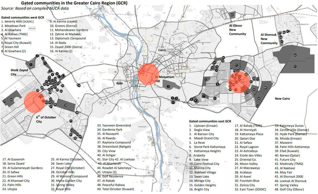
FIGURE 1. Location of the three centers under investigation in the Greater Cairo Region (entitled on a map with the numbering of gated communities (Ahmed, 2009)).
Walkability and bikeability were analyzed for the three city centers using the Walk Score. Integration of urban form was analyzed using a space syntax in depth map within a 1.5 km catchment area from the main square or center. Collective data were used as a framework of outcomes.
There are several programs used to measure walkability, such as the Walk Score, Street Smart Walk Score, Walkability Index, and toolkits and indices. The Walk Score analyzes a location’s pedestrian friendliness by looking at the distance to nearby amenities like restaurants, grocery stores, parks, and schools. It then assigns a score between 0 and 100 based on how easy it is to walk to these amenities. The Street Smart Walk Score and Walkability Index take this a step further by factoring in important pedestrian-friendly features like sidewalks, crosswalks, and pedestrian signals. Unfortunately, the latter could not be used in the case study due to the absence of many signals, crosswalks, and sidewalks, which would affect the validity of the study. That is why space syntax was used in addition to the Walk Score as a more complex and accurate method of measuring integration and accessibility (Walk Score: https://www.walkscore.com/; Pedestrian and Bicycle Information Center, 2023).
The Walk Score is a site that provides walkability analysis for different areas around the world according to the street network, urban form, and number of activities and facilities in the area. The walkability index provides a numerical walkability score between 0 and 100. Between 0 and 24 is considered a car-dependent area, 50–69 is somewhat walkable, 70–89 is very walkable, and 90–100 is a walker’s paradise, which means all errands, activities, and the street network are within a walkable distance. It also provides a bike score that complements the street network of the same area (Walk Score: https://www.walkscore.com/).
Space syntax analysis is conducted using DepthMapX, a software platform that performs a set of spatial network analyses designed to understand social processes within the built environment. The objective of the analysis is to derive variables such as the integration of urban form that may have social significance. After drawing the maps of the three city centers on AutoCAD, a DXF file is imported into DepthMapX to produce axial and segment maps. Connectivity, integration, node count, and total depth are then extracted as attributes from the segment maps of the proposed areas.
Space syntax can be used as a reproducible methodology as it is a method of analyzing street networks to understand how they impact human behavior and movement. It is based on the idea that the physical layout of a space affects how people use it and interact with each other. Space syntax uses mathematical algorithms to analyze the spatial relationships between different parts of a built environment. It can help architects, urban planners, and researchers understand and predict how people will move through different spaces and how effective different designs are at promoting social interaction and pedestrian flow. The different methods and software programs used in space syntax involve creating a graph-based representation of the built environment and analyzing its connectivity and centrality. These analyses can reveal patterns of movement and clustering that can inform design decisions and urban planning strategies (Penn, and Turner, 2001; Kim, and Seo, 2018).
Researchers have found that there is a strong relationship between space syntax, walkability, and bikeability. One study by Miller et al. (2014) found that neighborhoods with higher space syntax integration scores (meaning a more connected street network) were associated with increased walking and cycling activity. Similarly, a study by Sung et al. (2016) found that more connected and compact neighborhoods were associated with higher levels of walking, cycling, and transit use, as well as lower levels of driving. Another review by Zhang et al. (2019) supported these findings and suggested that space syntax can be used to design neighborhoods that promote active transportation, such as walking and cycling. This can be achieved through strategies such as creating more direct and connected walking and cycling routes, reducing street lengths, and improving connectivity between neighborhoods. Overall, the evidence suggests that space syntax is a valuable tool for designing neighborhoods that promote active transportation (walking and cycling). By analyzing the layout of urban areas and designing for improved connectivity and compactness, environments that are more conducive to active transportation can be created, which will ultimately improve the health and wellbeing of residents.
Meanwhile, Cairo, the capital of Egypt and a dense city known for its rapid population growth, with more than 20 million inhabitants, is expected to increase to 24 million inhabitants by 2027. The city is well known for its high car dependency rate, dense street network, and continuous traffic jams. The lack of mobility options is a serious problem in Greater Cairo, with serious effects on the quality of life, time consumption, and economy. In addition, the increase in fuel prices is driving many daily commuters to explore other alternative transport options. Regarding these considerations, several projects for sustainable transport modes have been developed in Cairo over the past few years. One of these projects is the new “Cairo Bike” project, which offers a large cycling network facility in the Downtown Cairo area (Carolyne Mimano, 2021).
Several studies have been conducted on the GCR, and findings state that the spatial configuration of the street network, which creates the urban fabric, plays a vital role in enhancing walkability. Studies show that compact urban fabrics with friendly, narrow, shaded streets are more pedestrian-friendly spaces that enhance walkability, compared to scattered layouts that hinder movement between destinations and activities (Abedo et al., 2020).
In addition, the street layout in the GCR is not designed with separate cycling lanes or separate public bus lanes. This leads to fewer cyclists using the same roads as vehicles and feeling unsafe due to direct contact with vehicular traffic. The lack of designed separate bus lanes also leads to interference with heavy traffic and irregular bus timetables. Moreover, pavement spaces are nearly inadequate for the density of pedestrians in many downtown areas. This is a huge concern as it is the main factor contributing to walkability, car dependency, and traffic jams in city centers.
In this paper, cycling, walkability, and urban form indicators deduced in Table 1 from the literature review will be analyzed in three city centers using space syntax to assess the level of integration of street networks and urban patterns and the Walk Score to determine the level of walkability in each city center. The relationship between urban form and walkability/bikeability will show which centers are user-friendly and walkable and which are not. Successful city centers like Old Cairo downtown are being analyzed further through the new “Cairo Bike” project as a successful example of a walkable neighborhood to deduce a framework for further implementation in future projects.
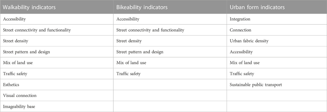
TABLE 1. Indicators of walkability, bikeability, and urban form (author).
Downtown Cairo has been the urban center of Cairo since the 19th century, when the district was designed and built. The urban planning of the area followed a European style with broad, linear, gridded streets. Incorporating many administrative buildings like the Tahrir building, stock exchange building, and others, as well as facilities like hotels, university campuses, cultural centers, and open markets, the old downtown is dense with activities, which turns the area into a user-friendly, walkable zone.
The Walk Score of Downtown Cairo shows that the district is a “walkers’ paradise,” which proves that daily errands do not require a car and can be made on foot (Figures 2, 3).
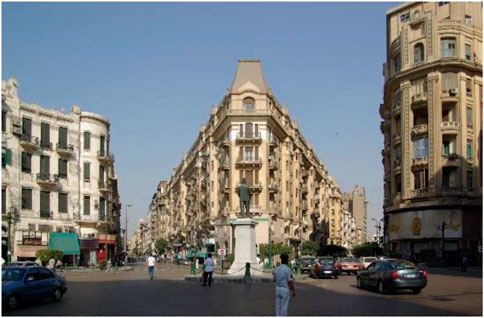
FIGURE 2. Walk Score of Downtown Cairo on the right and district image on the left (https://www.walkscore.com/score/downtown-cairo).
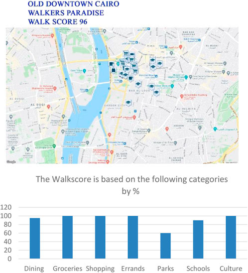
FIGURE 3. Graph showing categories of Walk Score value for Downtown Cairo (https://www.walkscore.com/score/downtown-cairo).
The attribute summary of the depth map shown in Table 2 describes the statistical properties of the depth values in the map. This includes measures such as minimum value, maximum value, average value, standard deviation of depth values, and other statistical indicators that give an overall understanding of the distribution of the depths in the map. Table 2 shows higher values of connectivity (integration and depth) within every 200 m radius compared to the other areas of study. Other measures, such as choice (degree of freedom and intelligibility), control (control over movement), and node count, show that the space is well connected, easy to navigate, and has more opportunities for social interaction and surveillance.
TABLE 2. Attribute summary of downtown Cairo (author, DepthmapX 0.8.0, 2010).
Using space syntax, an axial map and a segmented map were created. Measures of integration on every 100 m scale were calculated, as shown in Figures 4, 5. Table 2 shows the high level of integration of the street networks in Old downtown Cairo, which explains the highly accessible streets. Patterns of activity and compact urban form prove the high walkability initiative in the area, which answers the first question of the research: “What is the rate of walkability/bikeability in the city center of downtown Old Cairo?”
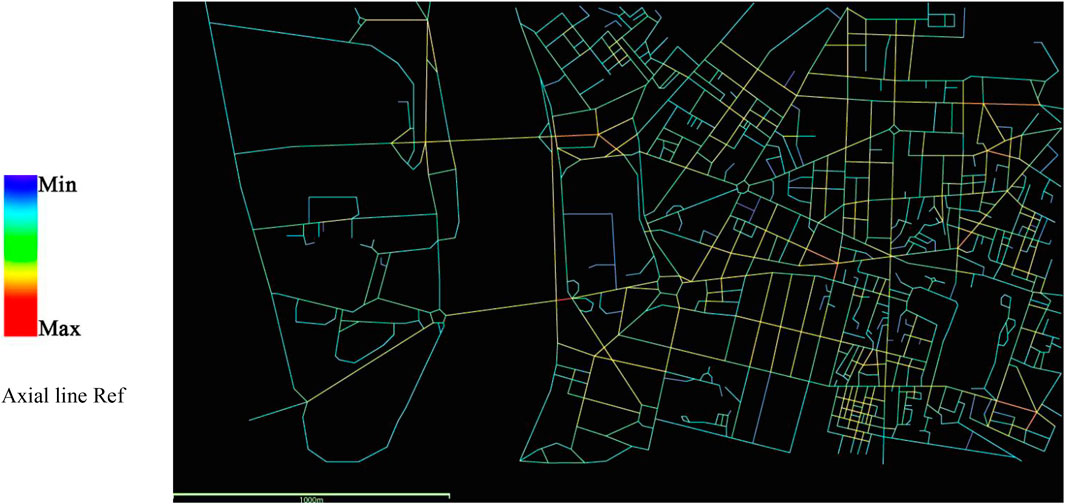
FIGURE 4. Segment map of downtown Cairo (author, DepthmapX 0.8.0, 2010).
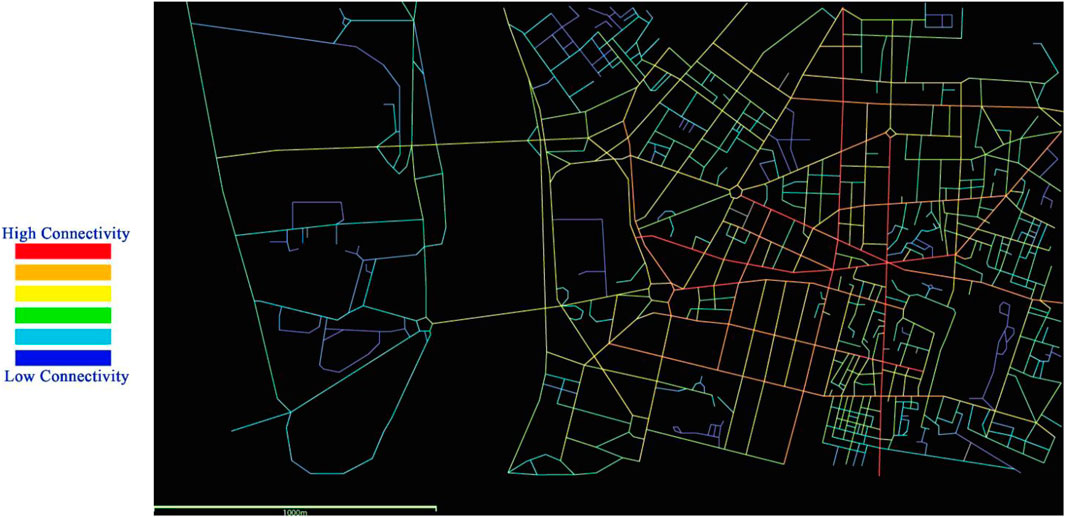
FIGURE 5. Integration analysis map of downtown Cairo (author, DepthmapX 0.8.0, 2010).
y using space syntax in case studies, the morphological form of the urban fabric is being measured, which includes street configuration (including size, shape, and arrangement of streets) and public spaces. Street connectivity and integration level are two of the measurements of walkability and bikeability, which are also studied by space syntax.
Table 2 shows an average connectivity level of 3.728 between a minimum value of 0 and a maximum value of 8, which describes a high level of connectivity compared to the next two case studies. The segment length has an average value of 61.9, which is lower than that in the other two case studies. This indicates short street lengths with high intersections, which means better overall compactness and connectivity. Integration has an average value of 273, which is also higher than that in the other two case studies. Therefore, the overall values are proof of a compact, dense, well-connected, and integrated fabric that enhances walkability/bikeability.
The attribute summary shows that integration in downtown Cairo is high due to its compact fabric. Because of this integration and the high Walk Score, it was easy to develop a new cycling network (Figure 6). In this context, the Cairo Governorate, in partnership with the United Nations Human Settlements Programme (UN-Habitat), Drosos Foundation, and Institute for Transportation and Development Policy (ITDP), planned a new cycling project called “Cairo Bike,” shown in Figure 7. The project consists of three phases, of which the first phase has been constructed with approximately 700 cycles and an initial coverage area of 6.4 sq km. The project has 70 cycling stations: 13 small stations (10 docks), 44 medium stations (20 docks), and 13 large stations (30 docks) (Institute for Transportation and Development Policy, 2014; United Nations Human Settlements Programme, 2018).
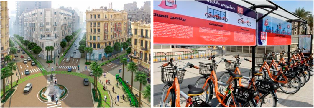
FIGURE 6. A render of bike lanes and stations at Talaat Harb square in central Cairo. Photo: Cairo Governate.
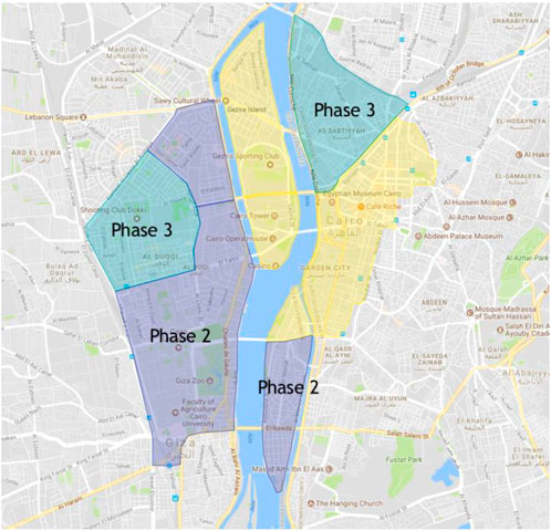
FIGURE 7. Cairo bike project phases on the map of downtown Cairo (United Nations Human Settlements Programme, 2018).
The target groups for this project are commuters who take the metro or bus to downtown Cairo but require a “last mile” option to reach their final destinations, workers who need to run short-distance errands during the day, and tourists who want to use bicycles to explore the city center. Stations have been placed at frequent intervals to provide coverage, with the distance between stations typically ranging from 200 to 400 m. The proximity to public transport hubs, public spaces, squares, commercial streets, and market areas was a priority when selecting cycle stations.
The proposed expansion plan adds service to Cairo University, Al Dokki, and the southern end of Zamalek Island in phase 2. The third phase extends the system to the AsSabtiyyah area and the rest of the Zamalek Island (Figure 8).
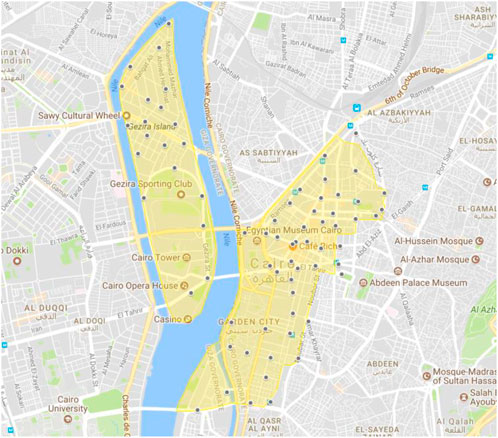
FIGURE 8. The planned bicycle sharing system will improve access in central Cairo (stations are shown in blue; coverage area is shown in yellow) (United Nations Human Settlements Programme, 2018).
6th October is a city in the Giza governorate, serving as a satellite town and a part of the urban area of Cairo. The settlement was established in 1978 by President Anwar el Sadat. In recent decades, gated communities have become a popular lifestyle choice for many residents and are the dominant form of expansion, covering 80% of 6th October City (Sims, 2010). However, as gated communities are spatially similar to enclaves, anthropologists such as Sheta M. Low have argued in her book, “Behind the Gates: Security and the New American Dream,” that they can have a negative effect on the broader community’s social capital outside the gated community (Low, 2004).
The Walk Score of downtown 6th October is 67 (Figure 9), indicating it is somewhat walkable but less so than Downtown Cairo. 6th October is primarily composed of closed gated communities with private activities and facilities in each one (Figures 10, 11). This lack of integration results in a less-compact urban fabric that negatively affects the walkability and bikeability of the area. Furthermore, the main streets in the city center are too wide, making it difficult to cross them safely due to a lack of street signs and crossings.
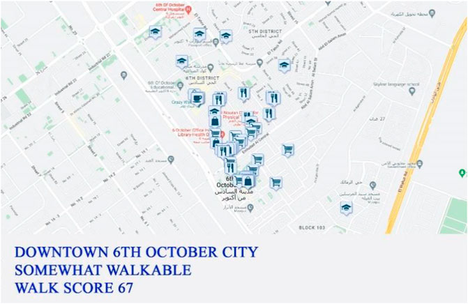
FIGURE 9. Walk Score of downtown 6th October district on the left (https://www.walkscore.com/score/6th-october-city-center).

FIGURE 10. District boundaries on the right (https://www.walkscore.com/score/6th-october-city-center).
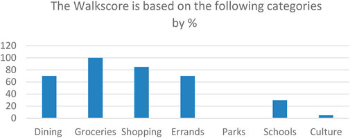
FIGURE 11. Graph showing the categories of Walk Score value for 6th October downtown (https://www.walkscore.com/score/downtown-cairo).
The analysis of the depth map shown in Table 3 reveals an average integration value of 59.811 and a connectivity value of 3.105 in downtown 6th October. The level of integration on different levels is lower than the integration levels in downtown Cairo. This is due to the increased number of gated communities with fences and walls, resulting in social segregation and decreased connectivity between the inside and outside of the communities. While this might improve walkability and bikeability inside these communities (Figures 12, 13), it also increases car dependency outside their walls. This answers the second and third questions in the methodology section concerning the rate of walkability and bikeability in extensions of the GCR and the factors affecting them.
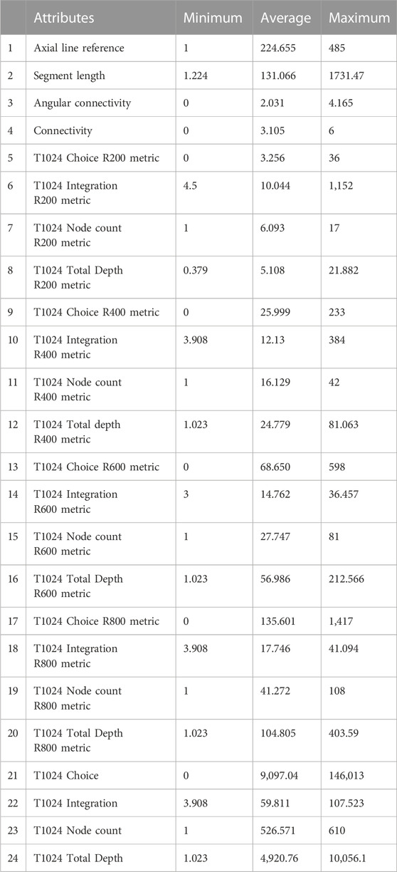
TABLE 3. Attribute summary of downtown 6th October (author, DepthmapX 0.8.0, 2010).
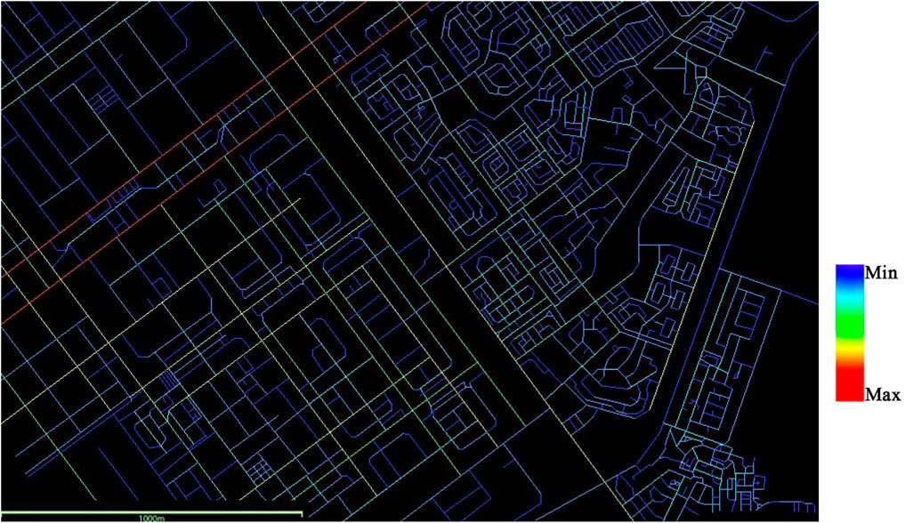
FIGURE 12. Axial map for 6th October downtown 3 km catchment areas (author, DepthmapX 0.8.0, 2010).
FIGURE 13. Integration analysis on segment map of downtown 6th October 1.5 km catchment area (author, DepthmapX 0.8.0, 2010).
In this section, we examine the morphological and functional attributes of the urban form discussed in the literature review and their impact on the safety, convenience, accessibility, and connectivity aspects of walkability and bikeability. The average segment length value of 131 shown in Table 3 highlights the long and wide pattern of most streets in downtown 6th October with limited intersections, signage, and stops, which negatively affects the safety of pedestrians and consequently impacts walkability and bikeability. The high percentage of gated communities also results in decreased connectivity and accessibility.
New Cairo is a new Egyptian settlement covering an area of about 30,000 ha on the southeastern edge of Cairo. It is one of the new cities built around Cairo to alleviate congestion in downtown Old Cairo. The Walk Score of downtown New Cairo is 13 (Figure 14), indicating that it is car dependent and less walkable than downtown Old Cairo and downtown 6th October. New Cairo is characterized by a wide street pattern in 70% of its street network, with a very small number of pedestrian crossings. It is partially filled with closed gated communities with private activities and facilities in each one (Figure 15), resulting in decreased integration and a less-compact urban fabric that negatively impacts walkability and bikeability.
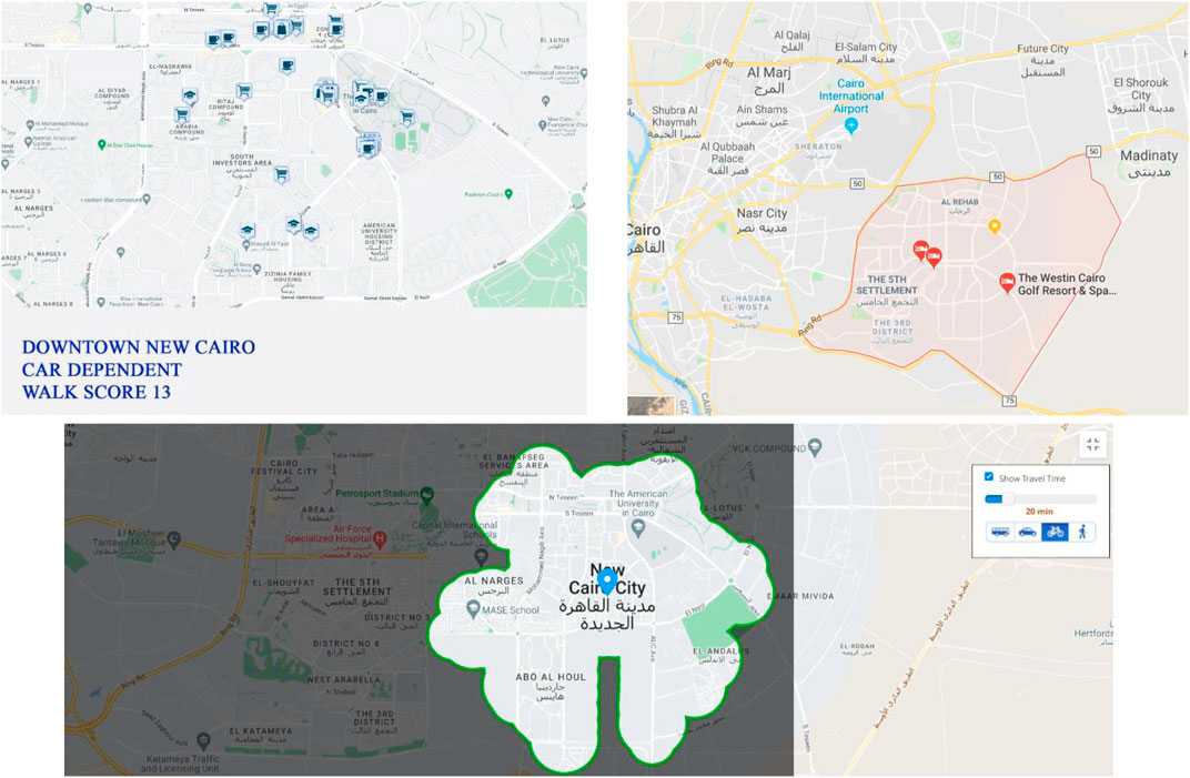
FIGURE 14. Walk Score of downtown New Cairo (upper left) city center boundaries (upper right) and travel time map (bikeable range 20 min) (bottom image) (https://www.walkscore.com/score/downtown-new-cairo).
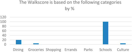
FIGURE 15. Graph showing categories of the Walk Score value for New Cairo downtown (https://www.walkscore.com/score/downtown-cairo).
Analysis of the depth map shown in Table 4 and Figures 16, 17 shows an average integration of 214.139 and an average connectivity value of 3.443. Integration on different levels in downtown New Cairo is lower than integration levels in downtown Old Cairo but higher than that of downtown 6th October. This is due to a well-arranged street network (with a medium segment length of streets), but at the same time, the wide street pattern intensifies the difficulty of crossings, thus affecting the safety, convenience, and accessibility measures of walkability/bikeability to some extent. This answers the second and third research questions in the methodology section concerning the rate of walkability and bikeability in the extensions of the GCR and the factors affecting them.
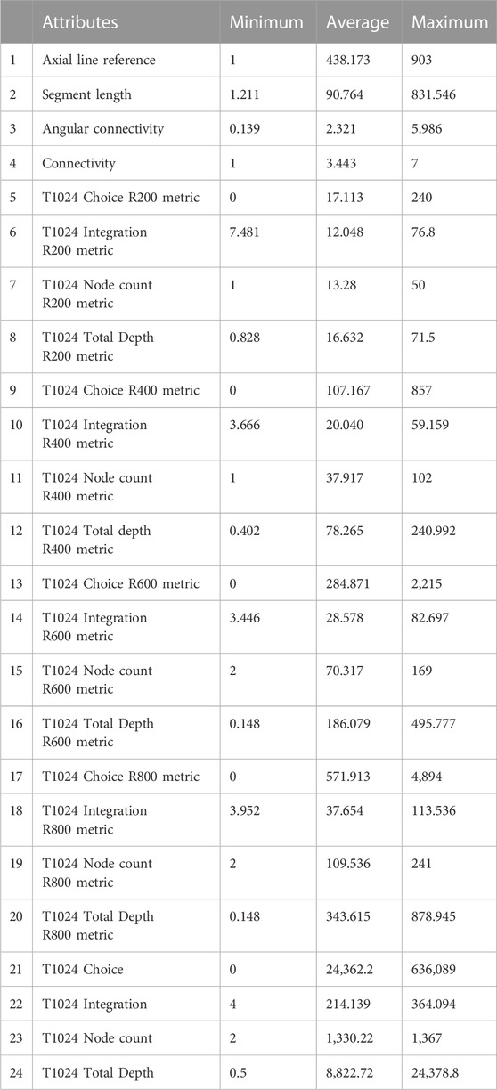
TABLE 4. Attribute summary of downtown New Cairo (DepthmapX 0.8.0, 2010).
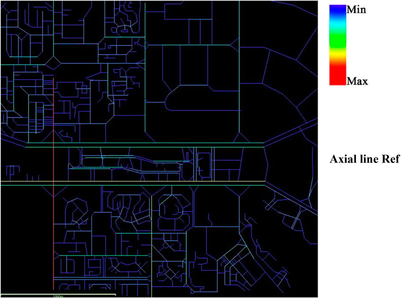
FIGURE 16. Axial map of the 1.5 km catchment area (author, DepthmapX 0.8.0, 2010).
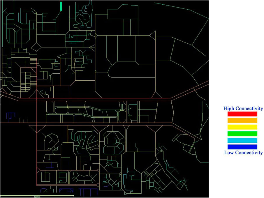
FIGURE 17. Integration analysis map of New Cairo downtown (author, DepthmapX 0.8.0, 2010).
Axial line reference
The urban context in many city centers differs in terms of integration, walkability, bikeability, and connectivity to activities and public transport stations. As shown in Table 5, the results indicate an average integration of 273.087 for downtown Cairo, compared to 59.811 in downtown 6th October and 214.139 in downtown New Cairo. These results are attributed to the differences in urban fabric connectivity and form. Integration in downtown Cairo is high, with a high Walk Score of 96%, due to its open, compact fabric and diverse range of activities, which has enhanced the Cairo bike project. On the other hand, integration is lower in downtown 6th October due to the presence of a large percentage of gated communities, which tend to reduce walkability and bikeability in the surrounding areas outside the community gates, resulting in a Walk Score of 67% (somewhat walkable). Downtown New Cairo has an average integration that is lower than that of downtown Cairo but higher than that of 6th October. This is because it has a mix of open fabric and closed gated communities. However, most activities in New Cairo are enclosed in gated malls, which make it more car dependent, resulting in a Walk Score of 13% (a car-dependent area). The node count in old downtown Cairo is higher than that of 6th October and New Cairo in all metrics due to the presence of more nodes, intersections, and connections in the urban pattern. Total depths are also higher due to shorter street lengths and more intersections. This affects the choice attribute, which is higher in old downtown Cairo, as there is more freedom of movement and proximity to different modes of transport and activities.
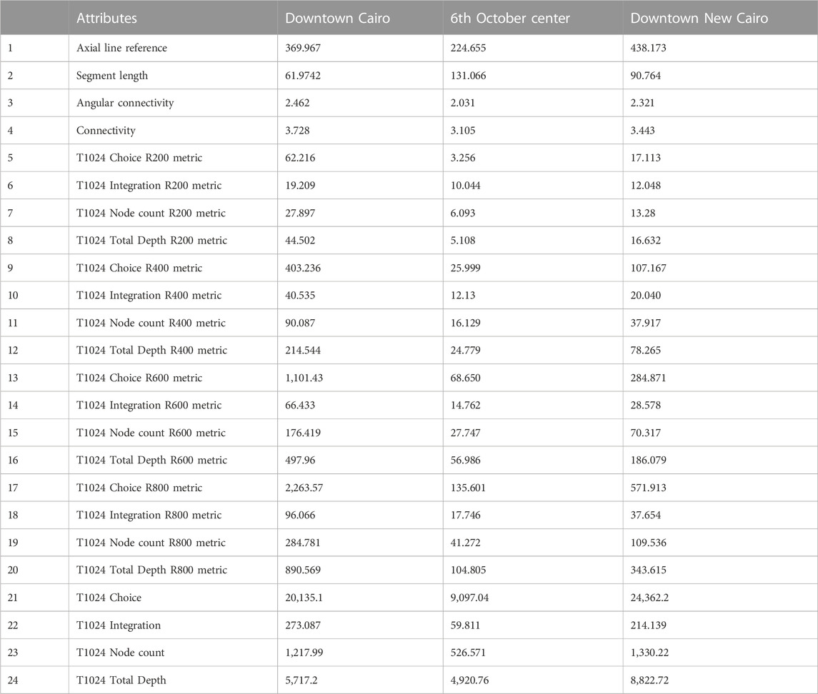
TABLE 5. Comparison of space syntax analysis in the three city centers of the GCR Source: own elaboration.
By analyzing the recent practice of gated communities and comparing it with sustainable urban practices of good community, connectivity, and social integration, we can see that this trend of urban expansion in the cities of 6th October and New Cairo has a direct impact on these factors. It results in reduced walkability and bikeability outside the gates of these communities, which affects the overall integration of the city, including its city center or downtown, and leads to more car dependency. This paper demonstrates that communities with a high percentage of gated communities lack connectivity with their local environment. This paper concludes that there is a direct relationship between bikeability, walkability, and urban form, which is affected by the different features of connectivity and activities that are previously described.
Despite the increased interest in studies on walkable and bikeable communities in developed countries, very few studies have highlighted the importance of walkability and bikeability in developing countries as a necessary step toward sustainability, especially in those places that are in dire need of reducing energy consumption and pollution resulting from transportation.
Stafford and Baldwin (2018) identified the relationship between walkability and the diversity of ages and abilities. Other studies, such as Greenstein’s (2015) research in Austin, Texas, have explored the relationship between bikeability and network density, land use, topography, and barriers. Wang et al. (2016) defined the relationship between walkability and bikeability in terms of several attributes of the built environment, such as housing design, the layout of public service facilities, the road traffic network, and the presence of green spaces and landscapes, which can affect physical activity and physiological health. Yen et al. (2021) suggested that the topological and geometric characteristics of street networks are more conducive to walking and biking in central districts than in peripheral districts. This study is the only source that pays attention to the difference between walkability and bikeability in central and peripheral districts. However, none of the studies mentioned the relationship between walkability, bikeability, and urban form. This paper proves that walkability and bikeability are directly affected by the integration of urban form, either through compact fabrics or gated communities. In addition, studies on walkability and urban form have been limited in developing countries like Egypt, particularly in the African context, in comparison to many studies that have been conducted in high-income countries. This offers a contextual novelty for this paper.
One of the knowledge gaps in urban planning for new extensions with gated communities is their potential impact on social and economic segregation. Gated communities are often designed to provide a sense of exclusivity and security, but they can also create physical and psychological barriers between residents and the wider community. Research has shown that gated communities tend to be more homogenous in terms of income, race, and ethnicity compared to surrounding neighborhoods, which can lead to greater social and economic segregation. This may have negative implications for social cohesion, access to public services, and economic opportunity. Another knowledge gap is the impact of gated communities on urban sprawl. Gated communities are often developed on the outskirts of cities, which can contribute to urban sprawl and an increased reliance on cars. This can have detrimental consequences for the environment, public health, and transportation equity. Furthermore, there is a lack of research on the long-term sustainability of gated communities. Many of these communities rely on private infrastructure and services, which can be expensive to maintain over time. There is also a risk that gated communities may become isolated and vulnerable in the event of natural disasters or other emergencies.
In addition, most articles and studies on sustainable active transport have been concentrated in Europe and America; on the contrary, limited studies have been made in developing countries that deal with the rapid growth of population, urban sprawl, and low income. This highlights the importance of this research in mitigating several opportunities as sustainable approaches for planning new extensions in developing countries. Evidence-based or data-driven studies on walking and biking behaviors in the large cities of the MENA region are scarce. One of the few studies of this kind shows that among socioeconomic factors, age, household car ownership, and last relocation time determine whether adults commute to work or study places. According to this study, the variables related to street network and accessibility can also significantly define on-foot commuting. These include intersection density, number of accessed facilities from home, average walking accessibility to neighborhood amenities, and commuting distance (Masoumi and Sierpiński, 2022). The present study on Cairo confirms the finding that street networks can encourage pedestrian trips in the large cities of the MENA region. The findings of this paper are also in line with a previous study on Cairo, Istanbul, and Tehran that indicated the proximity of the destination can encourage passengers to walk more. In fact, faraway destinations are the most effective barrier against not walking in the large cities of the MENA (Masoumi, 2019). The results of the present paper agree with those findings in terms of the compactness of urban fabric. However, compactness will be effective if it is combined with accessibility to neighborhood amenities, in other words, destinations to walk to. Because of socioeconomic, geographic, and cultural circumstances, these findings are generalizable and transferable to 27 cities with more than one million inhabitants in the MENA region (Masoumi and Fruth, 2020).
Furthermore, several limitations were observed during the study, such as the difficulty of collecting data on bus stops in various areas, the absence of a database for public transportation networks integrated into city centers, and the challenge of tracking the number of users of public and active transport through GIS, GPS, and other applications. Another limitation of the study is the weak connection between public and private authorities in the decision-making process in most cities in Egypt.
In future research, the possibility of simulation using space syntax has proven to be effective to a significant extent, as it can investigate other cases with real situations on the ground. The space syntax technique can be used as a predictor in analyzing walkability and testing the integration of street networks and urban patterns in different locations to make further decisions concerning street layouts, patterns, connections, activities, and transportation modes.
The GCR, with more than 19 million inhabitants, is an important contributor to the Egyptian economy. Traffic congestion is a serious problem in the GCR, with large and adverse effects on the quality of life and the economy. In addition to the time wasted in traffic, which could be put to more productive uses, traffic congestion results in fuel consumption, lower air quality, fewer productive hours, and increased transport costs for businesses. Therefore, serious steps should be taken to turn the vision into increased dependence on active and sustainable transport systems, such as walkability and bikeability, while reducing car dependency.
Our investigation into walkability and bikeability in compact fabrics versus gated communities has revealed that compact fabrics offer better options for active transportation. This is due to their mix of land uses, higher population densities, and well-connected street networks, which provide shorter, more direct routes for pedestrians and cyclists. On the other hand, gated communities often have limited connectivity with the outside fabric and restrictive design features that prioritize vehicular traffic over pedestrian and cycling modes. Overall, more research is needed to better understand the potential benefits and drawbacks of gated communities in new extensions and to develop strategies for creating more inclusive, sustainable, and resilient communities.
After studying the urban form and integration of the three city centers in the GCR and examining the main features affecting urban sustainability and connectivity, it has been proven that the compact fabric of the old city centers is the best model that can integrate connectivity and provide high accessibility to public transportation and different activities. It can also be deduced that the new extensions of GCR have a high degree of car dependency and low integration due to the presence of gated communities. Therefore, this paper recommends, as part of future agenda, the elimination of gated communities in new settlements. In addition, several recommendations are proposed for the Ministry of Housing and Construction and the Ministry of Transportation regarding how walkability and bikeability can be enhanced in the context of gated communities by
• Locating the main services and facilities on the borders of the community and being operable to serve from both sides. This will increase the economic and social value of these facilities, not only for residents of the community but also for others outside.
• Bordering the communities with landscaping instead of rigid fencing will enhance integration with the surrounding context and facilitate social interaction.
• Enhancing the design of open malls and markets on streets to increase social interaction.
• Adding pedestrian crossings with street and traffic signs at every intersection to enhance walkability.
• Separating public transport into separate lanes with clear integrated bus stops at continuous intervals will enhance walkability and dependence on public transport.
• The design of separate, continuous bike lanes for bikes and scooters will enhance bikeability and walkability.
The suggested strategies function better when there is an integration of urban land use planning and transportation planning. For instance, providing a city with short distances planned for active transportation can be realized by a more connected street network, which cannot be offered by urban planning or transportation planning alone. The lack of harmony between urban planning and mobility planning is seen in many developing countries. Planners and community developers to prioritize and invest in creating compact fabrics that facilitate safe and accessible active transportation for all residents. By incorporating these approaches into urban planning for new extensions, cities can create more livable, vibrant, and resilient communities.
The original contributions presented in the study are included in the article/supplementary material; further inquiries can be directed to the corresponding author.
Conceptualization, methodology, analysis, and writing—original draft preparation: SE. Supervision and review: HM. All authors contributed to the article and approved the submitted version.
The authors acknowledge support by the German Research Foundation and the Open Access Publication Fund of TU Berlin.
The authors declare that the research was conducted in the absence of any commercial or financial relationships that could be construed as a potential conflict of interest.
The handling editor GS declared a past co-authorship with the author HM.
All claims expressed in this article are solely those of the authors and do not necessarily represent those of their affiliated organizations, or those of the publisher, the editors, and the reviewers. Any product that may be evaluated in this article, or claim that may be made by its manufacturer, is not guaranteed or endorsed by the publisher.
Abedo, M., Salheen, M., and Elshater, A. (2020). “The dawn of walkability,” in Humanizing cities through car-free city development and transformation (IGI Global), 98–114.
Ahmed, Y. (2009). The privatization of urban development in cairo: Lessons learned from the development experience of Al rehab gated community. Egypt: Faculty of Urban and Regional Planning, Cairo University.
Al-Mosawy, S. K. A., Al-Jawari, S. M., and Al-Jabari, A. A. (2020). The effect of urban form on temperature for hot arid zones. The case study of baghdad, Iraq. IOP Conf. Ser. Earth Environ. Sci. 459, 062109. doi:10.1088/1755-1315/459/6/062109
Ali, M. S., and Park, J. (2020). A review of urban fabric classification. Sustainability 12 (21), 8942.
Ali, M. S., and Park, J. (2019). Analysis of urban fabric types by morphological classification. Sustainability 11 (10), 2930.
BenDor, T. K., and Metzger, J. T. (2017). Planning support systems for sustainable urban development. Springer.
Carolyne Mimano (2021). Insights from cairo: Improving mobility through bikeshare”. ITDP Africa, Institute for Transportation and Development Policy report.
Chataway, E. S., Kaplan, S., Nielsen, T. A. S., and Prato, C. G. (2014). Safety perceptions and reported behavior related to cycling in mixed traffic: A comparison between brisbane and copenhagen. Transp. Res. Part. F. Traffic Psychol. Behav. 23, 32–43. doi:10.1016/j.trf.2013.12.021
DepthmapX 0.8.0 (2010). DepthmapX 0.8.0. Available at: https://www.spacesyntax.online/software-and-manuals/urban-performance-model/process-space-syntax-measures/.
Elshater, A. (2012). New urbanism principles versus urban design dimensions towards behavior performance efficiency in Egyptian neighbourhood unit. Procedia - Soc. Behav. Sci. 68, 826–843. ISSN 1877-0428. doi:10.1016/j.sbspro.2012.12.270
Elshater, A., Abusaada, H., and Afifi, S. (2019). What makes livable cities of today alike? Revisiting the criterion of singularity through two case studies. Cities 92, 273–291. doi:10.1016/j.cities.2019.04.008
Greenstein, A. (2015). Mapping bikeability: A spatial analysis on current and potential bikeability in Austin. Texas: University of Texas at Austin. http://hdl.handle.net/2152/32204.
Heart Foundation (2020). The Active Living Research Walkability Checklist. Australian Government: Community Walkability Checklist.
Heesch, K. C., and Sahlqvist, S. (2013). Key influences on motivations for utility cycling (cycling for transport to and from places). Health promot. J. austr. 24, 227–233. doi:10.1071/he13062
Hillier, B., and Hanson, J. (1984). The social logic of space. Cambridge University Press. https://www.walkscore.com/score/downtown-cairo.
Huddleston, N. (2012). Climate change: Evidence, impacts and choices. PDF Booklet, Washington, DC: The National Academies Press.
Institute for Transportation and Development Policy (2014). The bike-share planning guide. Retrieved from https://www.itdp.org/wp content/uploads/2014/07/ITDP_Bike_Share_Planning_Guide.pdf.
Khan, F. M., Pafka, E., and Kim, D. (2021). Understanding informal functional mix: Morphogenic mapping of old dhaka. J. Urbanism Int. Res. Placemaking Urban Sustain., 1–19. doi:10.1080/17549175.2021.1979085
Kim, Y. O., and Seo, K. W. (2018). A review of space syntax studies in urban planning and design. Sustainability 10 (8), 2909.
Kim, H. (2020). Wearable sensor data-driven walkability assessment for elderly people. Sustainability 12, 4041. doi:10.3390/su12104041
Kostof, S. (1992). The city assembled: The elements of urban form through history. London: Thames and Hudson.
Kostof, S. (2001). The city shaped: Urban patterns and meanings throught history. London: Thames and Hudson.
Laker, L. (2017). Where is the world’s most walkable city. Retrieved from https://www.theguardian.com/cities/2017/sep/12/walkable-city-worlds-most-new-yorkmelbourne-fes-el-bali.
Lawlor, M. (2015). Case study analysis of the attributes of walkability. J. Sustain. Mobil. 2 (2), 54–66. doi:10.9774/GLEAF.2350.2015.de.00006
Low, S. (2004). Behind the gates: Security and the new American Dream. New York and London: Routledge.
Lydon, M., and Garcia, A. (2015). Tactical urbanism: Short-term action for long-term change. Island Press.
Mahmoudi, M., Ahmad, F., and Abbasi, B. (2015). Livable streets: The effects of physical problems on the quality and livability of Kuala Lumpur streets. Cities 43, 104–114. doi:10.1016/j.cities.2014.11.016
Masoumi, H. E. (2019). A discrete choice analysis of transport mode choice causality and perceived barriers of sustainable mobility in the MENA region. Transp. policy 79, 37–53. doi:10.1016/j.tranpol.2019.04.005
Masoumi, H., and Fruth, E. (2020). Transferring urban mobility studies in tehran, Istanbul, and cairo to other large MENA cities: Steps toward sustainable transport. Urban Dev. Issues 65, 27–44. doi:10.2478/udi-2020-0003
Masoumi, H., and Sierpiński, G. (2022). The land use and individual correlates of pedestrian commuting: Who walks to their work or place of study in the large cities of the MENA region? Sustainability 14, 6377. doi:10.3390/su14106377
McNeil, N. (2011). Bikeability and the 20-min neighborhood: How infrastructure and destinations influence bicycle accessibility. Transp. Res. Rec. 2247, 53–63. doi:10.3141/2247-07
NACTO (2016). Global street design guide. Chicago, IL: National Association of City Transportation Officials, Island Press, 3–16.
Newman, P., and Kenworthy, J. (1999). Sustainability and cities: Overcoming automobile dependence. Washington, D.C: Island press.
Olivier, J. G., Peters, J. A., and Janssens-Maenhout, G. (2012). Trends in global CO2 emissions 2012 report. The Hague: PBL Netherlands Environmental Assessment Agency.
Pedestrian and Bicycle Information Center (2023). Pedestrian and bicycle information center. Available at: https://www.pedbikeinfo.org/data/library/details.cfm.
Penn, A., and Turner, A. (2001). Space syntax-based urban design research and pedagogy: A review and critique. Environ. Plan. B Plan. Des. 28 (1), 123–146.
Sharifi, A. (2019). Resilient urban forms: A review of literature on streets and street networks. Build. Environ. 147, 171–187. doi:10.1016/j.buildenv.2018.09.040
Sims, D. (2010). Understanding cairo: The logic of a city out of control. Cairo: The American University in Cairo Press.
Smart Growth America (2018). Smart Growth America Complete streets Checklist. https://smartgrowthamerica.org/app/legacy/documents/cs-checklist.pdf.
Stafford, L., and Baldwin, C. (2018). Planning walkable neighborhoods: Are we overlooking diversity in abilities and ages? J. Plan. Literature 33 (1), 17–30. doi:10.1177/0885412217704649
Stevens, Q., and Kim, D. (2022). Temporary and tactical urbanism:(Re) assembling urban space. Oxfordshire: Routledge.
United Nations Human Settlements Programme, (2018). Institute for transportation and development policy, bicycle sharing feasibility study for cairo report.
Walk Score (2023). Walkscore Methodology. https://www.walkscore.com/methodology.shtml.
Wang, Y., Chau, C. K., Ng, W. Y., and Leung, T. M. (2016). A review on the effects of physical built environment attributes on enhancing walking and cycling activity levels within residential neighborhoods. Cities 50, 1–15. doi:10.1016/j.cities.2015.08.004
Winters, M., Sims-Gould, J., Franke, T., and McKay, H. (2015). I grew up on a bike: Cycling and older adults. J. Transp. Health 2, 58–67. doi:10.1016/j.jth.2014.06.001
Winters, M., Teschke, K., Brauer, M., and Fuller, D. (2016). Bike Score®: Associations between urban bikeability and cycling behavior in 24 cities. Int. J. Behav. Nutr. Phys. Act. 13, S72–S73. doi:10.1016/j.jth.2016.05.021
Yen, Y., Zhao, P., and Sohail, M. T. (2021). The morphology and circuity of walkable, bikeable, and drivable street networks in Phnom Penh, Cambodia. Cambodia. Environ. Plan. B Urban Anal. City Sci. 48 (1), 169–185. doi:10.1177/2399808319857726
Zayed, M. A. (2016). The effect landscape elements on walkability in Egyptian gated communities. Int. J. Archit. Res. Archnet-IJAR 2 (10), 113–129. doi:10.26687/archnet-ijar.v10i2.956
Keywords: sustainable development, cycling, walkability, urban form, gated communities, mode choice, travel behavior
Citation: Eldeeb S and Masoumi H (2023) Investigating walkability and bikeability in compact vs. new extensions: the case of Greater Cairo. Front. Built Environ. 9:1165996. doi: 10.3389/fbuil.2023.1165996
Received: 14 February 2023; Accepted: 15 June 2023;
Published: 03 July 2023.
Edited by:
Firas Alrawi, University of Baghdad, IraqReviewed by:
Krzysztof Rogatka, Nicolaus Copernicus University in Toruń, PolandCopyright © 2023 Eldeeb and Masoumi. This is an open-access article distributed under the terms of the Creative Commons Attribution License (CC BY). The use, distribution or reproduction in other forums is permitted, provided the original author(s) and the copyright owner(s) are credited and that the original publication in this journal is cited, in accordance with accepted academic practice. No use, distribution or reproduction is permitted which does not comply with these terms.
*Correspondence: Houshmand Masoumi, bWFzb3VtaUB6dGcudHUtYmVybGluLmRl
†ORCID: Sally Eldeeb, orcid.org/0000-0002-5065-9570
Disclaimer: All claims expressed in this article are solely those of the authors and do not necessarily represent those of their affiliated organizations, or those of the publisher, the editors and the reviewers. Any product that may be evaluated in this article or claim that may be made by its manufacturer is not guaranteed or endorsed by the publisher.
Research integrity at Frontiers
Learn more about the work of our research integrity team to safeguard the quality of each article we publish.