 Guadalupe Cantarero-García
 Marina Mollá
 Roberto Alonso González-Lezcano
- Escuela Politécnica Superior, Universidad San Pablo-CEU, CEU Universities, Urbanización Montepríncipe, Madrid, Spain
The Smart Citizen concept is at an early stage of research in the field of architecture and landscape architecture. ICTs and their use by citizens have been studied exclusively in the fields of engineering and telecommunications sciences as well as Artificial Intelligence. This study seeks to publicize the Smart Citizen concept in architecture and landscape from a spatial understanding and the perception of citizens with intellectual disabilities. A real case study developed by architects in collaboration with psychologists focused on the development of spatial intelligence for people with intellectual disabilities is presented in this study. “The students that participated in these activities belong to San Pablo CEU University course financed by ONCE Foundation (FONCE) and the European Social Fund.” The purpose is to question the effectiveness of the use of technologies for said cognitive development and how even the increased use of GPS navigator systems could be a detriment to the citizen when trying to orient him or herself in open spaces. The result to highlight in this review is to know if a person with a disability is equally capable of understanding a space and navigate it without the aid of GPS as a person without an intellectual disability. Both analogical tools (2D plan) and digital tools (GPS) are used under the same conditions. New lines of research are presented in the study of spatial intelligence through innovating tools or TICs in relation to urban elements where concepts like scale, proportion, light, and shade were identified.
1 Introduction
Intelligence applied to large cities is evaluated not only by present terms and technical aspects like sustainability, environmentalism, and TICs, but also on the basis of historical, sociological, landscaping, and urban factors with which a city is developed (Cantarero-García, 2018).
Intelligent cities use information and communication technologies to improve the quality of life of their citizens, the local economy, transportation, traffic management, the environment, and interaction with the government (Ismagilova et al., 2019). With the modernization of smart cities and the technological advancement of the Internet of things (IoT), we are now reaching a point where technology can be woven into the fabric of our cities (Dembsky et al., 2020; Baghezza et al., 2022).
Many demographic pressures have been solved with the use of digital technologies. The solutions implemented in intelligent cities within some developing countries can help satisfy the increasing demand of services and infrastructure (Shapiro, 2016; Tan et al., 2020). More and more, governments are implementing intelligent and digital strategies to promote citizen participation (Brenner, 2002; Caragliu et al., 2011; Van Den Berg et al., 2020). Useful directives were provided to politicians in charge and city administrators in order to define and to bolster their smart city strategies and their action plans towards appropriate implementation (Neiroti et al., 2014).
Researchers affirm that the rate and the reach of technology, as a force to solve problems, connect people, share information, and organize civic life, have increased as a result of COVID-19. They critically review how the use of technology influences the potential of civic commitment of an intelligent city, especially for people with disabilities. They also articulate new challenges for virtual participation in citizen life in terms of accessibility, viability, and fairness (Bricout et al., 2021).
Cardullo and Kitchin (2019) state that, in reaction to criticism of the smart city being too technocratic and instrumental, companies and cities have reformulated their initiatives to be more citizen-centric. They used this concept to measure the inclusion, participation, and empowerment of Smart Citizens in smart city initiatives. Both concluded that meaningful policies are needed to rethink the concepts of Smart Citizens and Smart Citizenship and smart cities need to be reworked if they are to really focus on the citizen.
Tomor (2020) shows that citizen participation in a smart city should not be understood as a technological utopia or dystopia, but as an evolving practice, technologically mediated and configured by a variety of factors. Nan and Pardo (2011) offer strategic principles that align with the three main dimensions of a smart city, which are technology, people, and institutions. The strategies are the integration of infrastructures and services mediated by technology, social learning to strengthen human infrastructure, and governance through institutional improvement and citizen participation.
Four years ago, on December 2–6, 2018 at the 18th International Conference on Electronic Business in Guilin, China, researchers from the Tsinghua University in China and the Northumbria University in the United Kingdom spoke of the four dimensions in the Smart Citizen study. The four dimensions are: 1) slacktivism and the knowledge bubble, 2) personal digitalization, 3) virtual social relationship, and 4) digital life process burden (Tian et al., 2018).
Blacut and Roche (2020) affirmed that smart cities are particularly suitable for improving urban inclusion by combining digital transition and social innovation. The authors demonstrated that, through spatial modification and having better control of spatial skills, deaf people can be offered new skills to improve their use of technology in support of urban mobility, as well as to provide them with tools to feel safer in urban environments. Researchers highlight the importance of an accessible environment to ensure the rights of people with disabilities. They show the role of urbanism in this process, addressing the concept and essence of urban planning and reveal a new task to provide accessibility for residents with disabilities (Kurbatova et al., 2020).
However, the advent of this new digital age brings with it new challenges, including the digital divide. Based on the context and problems of people with intellectual disabilities, researchers Romero-Torres and Lussier-Desrochers (2018) presented a model of accessibility for the digital world. They outlined possible solutions and three recommendations to develop alliances between citizens and institutions for creating an intelligent community.
In terms of citizen intelligence, the field of psychology has analyzed society in more detail as well as the behavior of the individual living within it. However, architects and urban planners have had little training in the physical-spatial interaction of the inhabitant in architecture and urbanism. In other words, a working connection is lacking between architects, urban planners, and engineers with psychologists.
Intelligence is the general mental capacity that implies, among other things, aptitude to reason, plan, solve problems, think in an abstract way, understand complex ideas, learn quickly, and learn from experience (Colom et al., 2022).
In 2019, R. J. Sternberg developed studies based on including and understanding intelligence such as the capacity of adaptation to one’s environment (Sternberg, 2019). He defends that to measure the traditional intellectual quotient (IQ), few speak of the capacity of the individual to adapt to the context. Other authors like H. Gardner with his popular theory of multiple intelligences Gardner (1983) or D. Goleman (1995) with the concept of emotional intelligence, also indicate other important factors in the understanding of the intellectual functioning of people.
Although the term intellectual disability (ID) has always been linked to the concept of intelligence, new theoretical models try to move away from the most rigid criteria of the understanding of ID, which only considers the IQ, and take into account other aspects (Carrillo Marcos, 2013). Shalock defines ID as a construct characterized by significant limitations in the ability to manipulate symbolic information and adaptive behavior (adaptive, conceptual, and practical skills) that affect one’s quality of life Shalock et al. (2010).
There is more and more research focused on evaluating different aspects of the life of people with disabilities and developing initiatives that improve their quality of life. In spite of this, in a context in which cities are more complex, it is still difficult to face all the necessities of the population and to motivate completely inclusive projects (Rebernik, 2017).
Little literature exists with studies on the relationship between the ID inhabitant, architecture, and urbanism, which gives rise to non-inclusive projects that foster inequality and the dependency of people with ID (Rebernik, 2017). In particular, some people with ID present or display deficits in their visuospatial abilities, which seriously harms their capacity for direction and, therefore, their autonomy (Rosselli, 2015).
The objective of this review is to establish a methodology to analyze the learning performance of students with disabilities with the use of tools that stimulate their visuospatial abilities. Two spatial activities were developed that serve to implement the method. Two specific places were selected for the development of these activities. The first area is a limited section in the Madrid Río area (Space SA1-Activity 1) to the south of the capital of Spain. The second is within a university campus (SA 2- Space Activity 2) with the purpose of establishing a time lag route. To carry out this objective, the following hypotheses are proposed:
- The use of spatial orientation GPS tools improves the learning of students with disabilities in comparison with the use of other traditional methods.
- The place, whether it be inside or outside, urban or natural, where learning with the use of spatial orientation GPS occurs, affects the results of the learning of the students with disabilities.
2 Methodology
2.1 Method design based on spatial intelligence and universal accessibility learning by students with intellectual disabilities
The methodology used seeks to demonstrate if a person with disabilities is independent and equally able to understand a space (and to maneuver within it without the aid of a GPS) like a person without an intellectual disability.
Both analogical tools (flat) and digital tools (GPS) were used under the same conditions. New lines of research presented in this study of spatial intelligence through innovating tools or TICs in relation to urban elements where concepts like scale, proportion, light, and shade were identified.
Usual activities in the field of architecture are combined with measurement tests based on specific methods for people with disabilities and those without disabilities.
These specific methods require:
- Working with a team of psychologists and architects.
- Choosing a place that favors a spatial experience.
- The activity previously designed and proven by educational architects that focused on students with intellectual disabilities and those without intellectual disabilities.
- To establish the phases of experimental study 1 and 2 that are detailed next.
- Analysis and data processing through the study of central tendency and dispersion measures (descriptive statistics etc.).
2.1.1 Experimental study phase 1
Method:
To instruct people in the use of GPS or landmarks for spatial orientation. To make a real route and verify which of the two conditions is more favorable for autonomy.
Hypothesis:
H1: People with disabilities will take more time to navigate a path guided by architectonic markers or visual keys.
H2: There exists a negative correlation between IQ and the amount of time to navigate a route in the group using GPS. (The lower the IQ, the longer the travel time with GPS).
Participants:
Inclusion criteria:
- People with ID and an IQ between X and Y.
- Age: 18–30 years
Exclusion criteria:
- Reduced mobility
2.1.2 Experimental study phase 2
Method:
To instruct people in the use of GPS or visual landmarks for spatial orientation. To navigate a real route and verify if any of the two conditions produce an effect on visuospatial abilities.
Hypothesis:
H1: People with disabilities will take less time to navigate a path guided by visual keys.
H2: There exists a negative correlation between IQ and the amount of time to navigate a route in the group using GPS. (The lower the IQ, the longer the travel time with GPS).
H3: The condition of visual keys is related to the significant improvement in tests of visuospatial abilities.
Participants:
Inclusion criteria:
- People with ID and IQ between X and Y.
- Age: 18 - X years
Exclusion criteria:
- Reduced mobility.
In order to initiate the design of the method, we started at the SA-1 (SA-1 Spatial Activity 1 in which we counted on 103 students) in the Madrid Río area, which was tested previously. It was carried out 4 years ago with more than one hundred students with disabilities and without disabilities. According to student profiles, some general results related to spatial understanding were found in verbal and written data (Cantarero-García 2020). In this SA-1, teachers from different disciplines met with a single didactic purpose: The analysis and evaluation of a single project such as the landscape and urban intervention of Madrid Río area through different means of documentation and representation of data. The SA-1 was developed in a singular, historical urban, and natural space that offers ample possibilities of study (UCM -Universidad Complutense de Madrid, UPM-Universidad Politécnica de Madrid).
These are the following groups of people involved in the research: Spatial Activity 1—EA 1:103 students participated in this activity:
22/103 students of Degree in Architecture—CEU.
8/103 students of Humanities and Communication Sciences Faculty—CEU.
47/103 students of Documentation UCM 7/103 students of the Master of Urbanism and Environment—UCM.
6/103 students—UPM.
13/103 students with intellectual disabilities (IQ less than 85. It is not allowed to get into personal details to preserve “personal and health rights”).
SA1 Faculty Team: 8 Professors plus 2 collaborators from the respective Universities.
To continue with the methodology, we designed an SA-2 (SA 2- Spatial Activity 2 in which we counted on 32 students) at the university campus of CEU San Pablo University. It was carried out in October of 2022 with more than thirty students. All of them with borderline intellectual functioning. In this spatial activity, some more specific results were obtained than in the SA-1.
They are presented here and they are related to the spatial understanding used on a route taken by foot that was a distance of 300 lineal meters between the departure and arrival points. In the SA-2, three college students from different disciplines were put together with a single scientific aim: temporary control of a route. The SA-2 was based on a single objective, which was to provide new conclusions to the question. The SA-2, therefore, does not require a unique context to fulfill the requirements of exit and arrival in a simple and measurable route in space and time.
These are the following groups of people involved in the research:
Spatial Activity 2—EA 2: 33 students with intellectual disabilities (IQ less than 85. We are not allowed to get into personal details to preserve personal and health rights):
15/33: UPM students
18/33: CEU students
SA2 Faculty Team: 3 Professors plus 3 collaborators from the respective Universities.
3 Results
3.1 Results of the activity proposed in SA-1
The results from the SA-1 (Figure 1) are:
- Descriptive development of the physical-sensory perception of light and color.
- Recognition of the concept of scale thanks to the understanding of their own shadow and that of other elements.
- Association of sensorial and auditory concepts like temperature and sounds with their own personal sensations like wellbeing or malaise.
- Knowledge of the concept of ergonomics and different elements of urban furniture such as benches, lampposts, wastebaskets, and fountains. Valuation of the urban furniture as being suitable or unsuitable for collective use and universal accessibility.
- Valuation of the flow of pedestrians such as the sensory perception of the intangible.
- Descriptive development of textures and the valuation of pavement to avoid children, people with physical disabilities, or people with mobility problems to fall.
- Valuation of the selection of framing one’s surroundings with the purpose of learning to suitably observe and analyze the space.
- The heterogeneity of the teaching staff favored using different approaches, but with a common objective: spatial perception and how it is perceived using different tools.
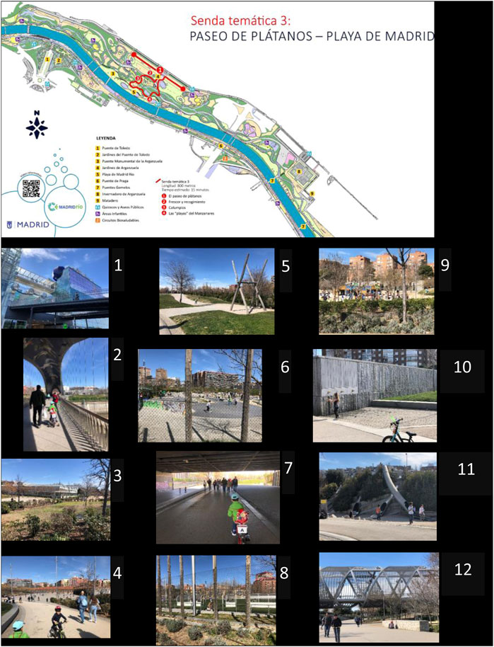
FIGURE 1. Map of numbered landmarks in the section analyzed in AE-1: Footpath 3. Madrid Río Paseo de Plátanos (Source of author).
3.2 Results of the activity proposed in AE-2
Results from the AE-2 (Figure 2) are:
- The time control data obtained shows that it took the group using GPS less time to complete the activity. In addition, if a student is taken out, there is a very low standard deviation and the median is practically equal to the mean. This indicates very similar behavior due to a good understanding of direction in practically all of those who used a GPS.
- The times may reflect normal distribution without bias and with the values centered on the mean. The difference between the mean (3:43) and median (3:25) is the time of one student who did not understand the information from the GPS well.
- The students who used a map showed a greater mean (4:21) than the students who used a GPS (3.43). This, combined with the fact that the standard deviation was higher (1.04 vs. 1:58), indicates that a higher proportion of students with a map did not clearly understand the destination or they did not travel the path to the destination with certainty. The minimum and maximum values indicate a big difference between the sample of students in their understanding of the path to follow.
- The median of students with maps (3:52) reflects a bias in the amount of time of several people who did not understand direction well. The difference between mean and median corroborates this.
- It is necessary to emphasize that the maps were from a 3D satellite view where volumes, scales, shadows, textures, colors, and precise dimensions of the surroundings, in terms of construction and nature, could be observed. Those using GPS were guided by Google maps in the version “arrive on foot” in 2D without the descriptions mentioned above in the maps. The 3D maps were more precise and to scale.
- We can conclude that the simplicity in the instructions helped the sample complete the route in less time. It would be interesting to suggest a hypothesis on whether the same results would be obtained if the route was longer or more complex.
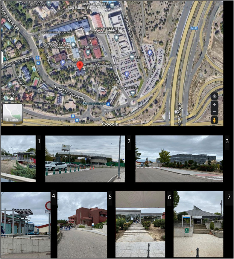
FIGURE 2. Map of numbered landmarks in the section analyzed in AE-2: University campus CEU Montepríncipe (Source of author).
4 Conclusion
Assuming that all citizens are not equipped with the same intellectual quotient and that a citizen will process information differently at different ages in his or her life, it is difficult to understand the concept of a Smart Citizen from a general spectrum. The citizen may suffer from a temporary or permanent disease that may cause the quotient to be lowered in a specific time throughout his or her life. For that reason, generalizing this concept is not advisable. Nevertheless, we can focus the study in the pertinent fields of investigation and thus understand how to improve the quality of life of a person with an intellectual disability and his or her integration into an inclusive society.
It is necessary for the physical space (not only the virtual one) to become a field of study for the development of spatial intelligence in people with intellectual disabilities and their interaction with the already studied smart city. This has yet to be determined.
These activities awaken an awareness of autonomy in the student and his or her non-dependence on digital systems. A comparison is established in using and not using technology in one’s day-to-day life and, as a personal challenge, allows the student to be in a space, urban or natural, and discover that the different elements can help guide him or her without the aid of a navigator.
It was necessary to start from this basic base to check results to take in consideration for next future steps that could open paths and new research hypotheses in which “time” is not the only factor involved but rather 2D or 3D Dimensions (if the 3D blueprint is better understood than the 2D blueprint), the environment or the landscaping character (if it is an urban landscape route or if it is a natural landscape route), Sun light (if the Sun lights and shadows affect to the orientation sense), the students age and the student’s IQ.
Despite the fact that the results indicate that GPS seems to be the most favorable condition for autonomy, it would be necessary to study whether, in the long term, the possible dependence on this tool favors or limits the development of visuospatial skills. For this reason, the implementation of putting into practice the present method opens up different lines of study in the field of architecture and psychology but also in other lesser-known fields such as optometry:
- Further development of the concept of the Smart Citizen in areas that are not only technological but humanistic as well.
- To introduce new tests that are specific to psychology and spatial perception in the field of architecture and landscape.
- To know the needs of the citizen with different capacities in order to understand universal accessibility in architecture and landscape.
Author contributions
Conceptualization, GC-L, MM, and RAG-L; methodology, GC-L, MM, and RAG-L; formal analysis, GC-L, MM, and RAG-L; formal analysis, GC-L, MM, and RAG-L; investigation, GC-L, MM, and RAG-L; resources, GC-L, MM, and RAG-L; data curation, GC-L, MM, and RAG-L; writing—original draft preparation, GC-L, MM, and RAG-L; writing—review and editing, GC-L, MM, and RAG-L; visualization, GC-L, MM, and RAG-L; supervision, RAG-L; project administration, GC-L; funding acquisition, RAG-L. All authors have read and agreed to the published version of the manuscript.
Funding
The authors wish to thank CEU San Pablo University Foundation for the funds dedicated to the ARIE Research Group, through the Project Ref. EC01/0720- MGI22RGL provided by the CEU San Pablo University.
Acknowledgments
This research is part of the financed project, El paisaje periurbano de Madrid: visiones desde la memoria hacia la nueva ciudad, translated into English as The Peri-Urban Landscape in Madrid: Visions from Memory to the New City (financed by El Ministerio de Ciencia e Innovación en la convocatoria 2019 Proyectos de I + D + i - RTI Tipo B. Translated into English as the Ministry of Science and Innovation of Spain, code PID 2019-110693RB-100). This research has been translated by Diana Claveria (Architect from the University of Westminster, London, RIBA member and translator: www.dyfconsultants.com).
Conflict of interest
The authors declare that the research was conducted in the absence of any commercial or financial relationships that could be construed as a potential conflict of interest.
Publisher’s note
All claims expressed in this article are solely those of the authors and do not necessarily represent those of their affiliated organizations, or those of the publisher, the editors and the reviewers. Any product that may be evaluated in this article, or claim that may be made by its manufacturer, is not guaranteed or endorsed by the publisher.
References
Baghezza, R., Bouchard, K., Bouzouane, A., and Gouin-Vallerand, C. (2022). Profile recognition for accessibility and inclusivity in smart cities using a thermal imaging sensor in an embedded system. IEEE Internet Things J. 9, 7491–7509. doi:10.1109/JIOT.2021.3127137
Blacutt, A. A., and Roche, S. (2020). When design fiction meets geospatial sciences to create a more inclusive smart city. Smart Cities 3, 1334–1352. doi:10.3390/smartcities3040064
Brenner, N., and Theodore, N. (2002). Cities and the geographies of “actually existing neoliberalism. Antipode 34, 349–379. doi:10.1111/1467-8330.00246
Bricout, J., Baker, P. M., Moon, N. W., and Sharma, B. (2021). Exploring the smart future of participation: Community, inclusivity, and people with disabilities. Int. J. E-Planning Res. 10, 94–108. doi:10.4018/IJEPR.20210401.oa8
Cantarero, G. (2020). Imaginar, compartir, crear: Consolidando la innovación docente en arquitectura coordinación. Madrid, Spain: Pablo Campos Calvo-Sotelo. http://es.wikipedia.org/wiki/Madrid.
Cantarero-García, G. (2018). "Reflexiones urbanísticas. Referencias del pasado y situación actual de Madrid como ciudad inteligente potencial, ” in Gestión inteligente y sostenible de las ciudades. Gobernanza, smart cities y turismo. Editors M. T. Dir, M. T. Cantó, J. Ivars, and R. Martínez (Valencia, Spain: Tirant lo Blanch), 101–125.
Caragliu, A., del Bo, C., and Nijkamp, P. (2011). Smart cities in europe. J. Urban Technol. 18, 65–82. doi:10.1080/10630732.2011.601117
Cardullo, P., and Kitchin, R. (2019). Being a ‘citizen’ in the smart city: Up and down the scaffold of smart citizen participation in dublin, Ireland. GeoJournal 84, 1–13. doi:10.1007/s10708-018-9845-8
Carrillo Marcos, M. (2013). Inteligencia, conducta adaptativa y calidad de vida: interacciones 363 explicativas de la discapacidad intelectual y la intervención optimizadora. Universitat Autònoma de 364 Barcelona Barcelona. Spain.
Colom, R., Karama, S., Jung, R. E., and Haier, R. J. (2022). Human intelligence and brain networks. Dialogues Clin. Neurosci. 12, 489–501. doi:10.31887/dcns.2010.12.4/rcolom
Dembski, F., Wössner, U., Letzgus, M., Ruddat, M., and Yamu, C. (2020). Urban digital twins for smart cities and citizens: The case study of herrenberg, Germany. Sustain. Switz. 12, 2307. doi:10.3390/su12062307
Ismagilova, E., Hughes, L., Dwivedi, Y. K., and Raman, K. R. (2019). Smart cities: Advances in research—an information systems perspective. Int. J. Inf. Manag. 47, 88–100. doi:10.1016/j.ijinfomgt.2019.01.004
Kurbatova, S. M., Aisner, L. Y., and Naumkina, V. V. (2020). “Accessible environment as a means of ensuring the rights of persons with disabilities and as a task of the modern social state,” in IOP conference series: Materials science and engineering. Bristol, UK: IOP Publishing Ltd. doi:10.1088/1757-899X/962/3/032074
Nam, T., and Pardo, T. A. (2011). “Conceptualizing smart city with dimensions of technology, people, and institutions,” in Proceedings of the ACM international conference proceeding series, 282–291.Honolulu, HI, USA February 2011 doi:10.1145/2037556.2037602
Neirotti, P., De Marco, A., Cagliano, A. C., Mangano, G., and Scorrano, F. (2014). Current trends in smart city initiatives: Some stylised facts. Cities 38, 25–36. doi:10.1016/j.cities.2013.12.010
Rebernik, N., Osaba, E., Bahillo, A., and Montero, D. (2017), 70–79.A vision of a smart city addressing the needs of disabled citizens, Proceedings of the Production of Disability Inclusive Public Spaces and Cities - Using Digital Tools and Participatory Practices,Malaga, Spain September 2017.
Romero, R., (2018). in Paisajes de aproximación a la ciudad de Madrid. Conarquitectura Ediciones Madrid, Spain.
Roselli, M. (2015). Desarrollo neuropsicológico de las habilidades visoespaciales y visoconstruccionales. Rev. Neuropsicol. Neuropsiquiatría Neurociencias 15 (1), 175–200.
Shapiro, J. M. (2006). Smart cities: Quality of life, productivity, and the growth effects of human capital. Rev. Econ. Statistics 88, 324–335. doi:10.1162/rest.88.2.324
Sternberg, R. J. (2019). A theory of adaptive intelligence and its relation to general intelligence. J. Intell. 7, 23. doi:10.3390/jintelligence7040023
Tan, S. Y., and Taeihagh, A. (2020). Smart city governance in developing countries: A systematic literature review. Sustain. Switz. 12, 899. doi:10.3390/su12030899
Tian, J., Li, H., and Chen, R. (2018). “The emerging of smart citizen concept under smart city environment,” in Proceedings of the 18th international conference on electronic business (Guilin, China, December 2018: 7392–7426.
Tomor, Z. (2020). Citizens in the smart city: What is actually happening? An in-depth case study from utrecht, The Netherlands. Int. J. Public Adm. Digital Age 7, 1–16. doi:10.4018/IJPADA.2020010101
Keywords: smart citizen, smart city, architecture, landscape, intelectual disability
Citation: Cantarero-García G, Mollá M and González-Lezcano RA (2023) Smart citizen in architecture and landscape. Method design based on spatial intelligence and universal accessibility learning by students with intellectual disabilities. Front. Built Environ. 9:1094760. doi: 10.3389/fbuil.2023.1094760
Received: 10 November 2022; Accepted: 02 January 2023;
Published: 13 January 2023.
Edited by:
Yaolin Lin, University of Shanghai for Science and Technology, ChinaReviewed by:
Graziano Salvalai, Politecnico di Milano, ItalyCopyright © 2023 Cantarero-García, Mollá and González-Lezcano. This is an open-access article distributed under the terms of the Creative Commons Attribution License (CC BY). The use, distribution or reproduction in other forums is permitted, provided the original author(s) and the copyright owner(s) are credited and that the original publication in this journal is cited, in accordance with accepted academic practice. No use, distribution or reproduction is permitted which does not comply with these terms.
*Correspondence: Guadalupe Cantarero-García, Z2NnYXJjaWFAY2V1LmVz