 Paul Cureton1*
 Elliot Hartley2
- 1ImaginationLancaster, Lancaster University, Lancaster, United Kingdom
- 2Garsdale Design Ltd., Sedbergh, Cumbria, United Kingdom
City Information Models (CIMs) present several research challenges and are arguably pre-cursors for a roadmap to the transition to Urban or City Digital Twins (UDTs/CDTs) and broader smart city drives. In a period of digital transformation in urban planning, CIMs are primarily designed to intersect and merge urban GIS/BIM in what is termed GeoBIM. CIMs are often cloud-based geospatial services and data repositories with one-way data connections, which differ from integrated and high-fidelity cyber-physical complex systems for digital twins (DTs). However, there is a lack of precision in terms of defining CIMs and UDTs, and this paper examines four broad sociotechnical research challenges regarding the progress of CIMs toward full UDTs/CDTs, including (1) technical training for adoption, (2) acquisition strategies for aerial data and remote sensing, (3) data licensing types and system management, and (4) stakeholder engagement with CIM platforms. These four research challenges and digital transformation are discussed by using back-casting futuring methods, establishing a framework for CIMs through co-designed workshops, and explored in the Lancaster City Information Model (LCIM) prototype. The LCIM, as a resulting case study, was developed for architects, planners, and stakeholders to engage with 3D urban models and urban analytics (view sheds, masterplan scenarios, and solar potentials of buildings) from 2019 to 2021 to address digital inequality in planning and data fragmentation. The framework and prototype results resulted in the most extensive 3D open urban dataset published in the UK, consisting of a baseline of 1″+/− buildings and infrastructure and 7.5 cm aerial imagery and a framework for developing transitions from CIMs to UDTs. The delivery of this case and the resulting published dataset highlights the essential research needed regarding definitions and precision around terminology and systems between CIMs and UDTs and four applied challenges in digital transformation and future socio-technical relationships.
Introduction and background
Numerous projects, commercial software packages, workflows, data standards, and policies have emerged within the last 5 years describing “digital twins” as novel and ground-breaking parts of smart cities (Deren et al., 2021). A working definition is that a digital twin is a “digital representation at a set fidelity, of a physical element including its behavior, which is connected and integrated for efficiency” (Cureton, forthcoming). In the UK context for digital twins, a range of national policies have been released, including: the National Infrastructure Commission-released Data for the Public Good: Government Response (2018); the National Data Strategy (2020), released by the DCMS; and a report on unlocking spatial data, Unlocking the Power of Location: the UK’s Geospatial Strategy (2020), released by the Geospatial Commission. Supporting these policies and strategies, the Centre for Digital Built Britain (CDBB), based at the University of Cambridge, UK, developed roadmaps for Digital Twins through the Gemini Principles (2018), Information Management Framework (2020), and Data Ontologies (2020) among other reports and research articles. The CDBB vision was to establish a National DT ecosystem through a Digital Twin Hub supported by the Digital Twin Consortium, an industry-led group, with the Connected Places Catapult. One output included a climate resilience demonstrator entitled CReDo, which is a climate change adaptation DT for a fictional city called Sunford1. The UK policy context sets out the essential benefits of digital twin adoption and broader developments of digitization and digital transformation in several sectors. The UK policy context is indicative of national initiatives around the globe for DT adoption. However, the DT research area is embryonic, and industry-led implementations in an infrastructure context are primarily at the prototype stages (Gürdür Broo and, Schooling, 2021, p.5). In a market context and indicating the growth and adoption of supporting policies, the broader digital twin sphere is expected to rise to 73.5 billion USD by 2027, with a compound annual growth rate (CAGR) of 60.6%2. Examining the definitions of digital twins also reveals the complexity and ambiguity of the term. DTs have a range of archetypal meanings and special cases and applications, which leads to a diversity of terms (van der Valk et al., 2021). City Digital Twins (CDTs) or Urban Digital Twins (UDTs) are one such example. The motivation for this research revolves around addressing this diversity of terms and understanding the current state of the art.
From the development of Building Information Modeling to urban 3D, GIS professionals have been researching and designing systems for working with complexity at multiple scales and at incremental stages with some paradigm shifts. City Information Models (CIMs), which were first termed for Autodesk University in 2007 by Lachmi Khemlani, seek the harmonization of differing fields. Situated between BIM, GIS, and the Internet of Things (IoT), CIMs broadly address Built Environment data processing, urban analytics, and visualization. CIMs are predominantly intended to bridge modeling paradigms and CityGML and IFC data standards as GeoBIM3 (de Laat and Van Berlo, 2011). As stated by Souza and Bueno (2022, p.2) in a systematic literature review of 80 articles between 2010 and 2021, there is no comprehensive definition of the CIM term. However, it is understood as a computational tool, GeoBIM, and an urban database for analysis and simulation. Compounding this issue is the same ambiguity of terminology surrounding the definition of the latest innovations for the digital twins of a built environment or CDT/UDT. CIMs are also interchangeably discussed as UDTs and often marketed as more advanced systems in the commercial sphere. This article seeks to clarify this ambiguity by analyzing the socio-technical systems and capabilities utilizing a process-based methodological approach to establish a framework for CIM development in other cities.
State of the art and objectives
UDTs offer various models of prediction and simulation and have the potential to radically alter forms of urbanization for sustainability in light of climate change and future shock through decarbonization, environmental solutions, and future planning. Major UDTs established to date include Virtual Singapore, Virtual Helsinki, and Virtual Gothenburg, with Chalmers University, all focused on architecture, planning, and smart city developments (Hämäläinen, 2021). Additionally, many major urban settlements are developing their road maps for digital twins as part of broad digitization drives from national governments. For example, Virtual Gothenburg is supported by a national geo-information strategy for Germany through a LiDAR acquisition program.
City Digital Twins (CDTs) or Urban Digital Twins (UDTs) are highly accurate platforms for considering our urban future. However, the design of UDTs for event-driven predictions, such as climate shocks, flooding, energy demand, or transport mobility, and the socio-technical relationships with these systems in terms of interaction and communication need to be urgently addressed. UDT’s 'real-time’ or live data from physical sensors as ‘cyber-physical’ systems (Ketzler et al., 2020) can inform more accurate, efficient, and transparent decisions in several fields such as energy, the environment, and transportation (Blair, 2021). Nevertheless, research is segmented and unconnected.
To understand the state of the art and the ambiguity surrounding the functionality of a DT, a precursory method was applied, called the backcasting method, to understand CIMs and the future of CDTs/UDTs. This method is not novel but has not been applied to CIMs or UDTs (to the authors’ knowledge based on an extensive literature review). Project Göteborg 2050 (Gothenberg, Sweden) by Phdungsilp, (2011) utilized backcasting as a futuring method for sustainable regional planning in energy, food, urban design, and transportation (2011); backcasting is an established method in the field of future studies (Dreborg, 1996).
The backcasting method sought definitive inventions of instruments, terminology, and real-world case studies that have connections to digital twins and are thematically divided into four phases (Figure 1). Furthermore, the method found a linear history of ICT developments in Built Environments. First, the birth of CAD and GIS through the first geographical information systems, sketch pad CAD applications, and VR headsets, as well as the birth of the first computer game simulating planning, “Micropolis,” which later became “SimCity”. Second, the emergence of the digital twin term, the Internet of Things (IoT), Smart Cities 1.0, City Information Models (CIMs), and Building Information Modeling (BIM). Third, data ontologies (CityGML), Digital Twins for Cities, and Smart Cities 2.0. And fourth, Connected Digital Twins for Cities and Urban Areas. The fourth phase indicates the linear progression of ICT technologies and real-world cases being implemented. This linear history crosses disciplinary areas such as urban geosciences, remote sensing, architecture, planning, data science, AI, robotics, IoT, engineering, and construction. This proposed timeline is not exhaustive, and several sub-themes could be added or the thematic interpretation subject to criticism. However, the timeline helps contextualize what UDTs are, their scope, and taxonomic development. This method of backcasting helped formulate the scope of enquiry for a case study and map future directions. The backcasting method revealed that many research projects had CIM capabilities but not as complete CDT/UDT systems.
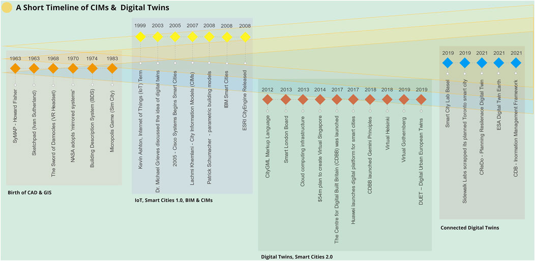
FIGURE 1. A visual timeline of the emergence of City and or Urban Digital Twins.
The LCIM’s longer-term aim was to address digital inequality and data fragmentation and explore the requirements for baseline data that would create a roadmap for a digital twin for urban planning for local authorities. For the LCIM, the research hypothesis explored what a demonstrator for a CIM would involve and how it would perform in the Lancaster area in the northwest UK. The objective of this research was to create a replicable framework for CIMs as a precursor toward CDTs/UDTs. To achieve reproducible results, this research needed to create a framework based on four areas of enquiry and establish a process-based methodological approach for the establishment of CIM. These four areas—people, data, systems, and engagement—were developed in mapping exercises in preliminary discussions of the development of the demonstrator and case study. The rationale followed a logical sequence of developing GIS-based tools for urban settings, which would achieve the research objectives. First, training for individuals and users for CIM adoption. Second, the creation of an acquisition strategy for aerial data and remote sensing. Third, deciding on open data licensing types, fourthly, management strategies, and stakeholder engagement techniques with CIM platforms. Following the initial framework and remit, the authors created the Lancaster City Information Model (LCIM) as a baseline CIM and identified the ambitions for the UDT. The research motivation was essential in identifying the transitional basis to avoid spurious technological capabilities and performance claims. The research demonstrator involved Lancaster City Council, Garsdale Design Ltd., CyberCity3D, and Bluesky International and utilized ESRI proprietary software from 2019 to 2021. CityEngine procedural software was intrinsic to the creation of this baseline. The LCIM research project was then applied and evaluated the limitations, opportunities, socio-technical relationships, and optimal designs for a CIM and explored the four framework attributes of technical training for professional adoption, acquisition strategies for aerial data and remote sensing, open data licensing types and system management and governance.
Research methodology
It is prudent to discuss the state of the art of a range of CIMs, assess limitations and functionalities, and compare the archetypes of UDTs. However, process-based methods were selected to form this analysis, including backcasting in the state of the art evaluation and in the LCIM-based framework of the four attributes, co-designed workshops, experimental 3D GIS training data, and UI prototyping to generate replicability. Process-based methods, such as co-design, have previously been applied for green infrastructure, urban planning (Basnou, et al., 2020), and geodesign as a methodological workshop approach for reaching data-driven consensus (Wu and Chiang, 2018). Government precedents have featured heavily in the LCIM 3D GIS, including the Dutch Land Registry Office for 3D Netherlands, since 2014. There are also a wide variety of UI prototyping methods, and the LCIM explored procedural modeling, parametric design, and user interfaces (Badwi, et al., 2022). The contribution to knowledge of the LCIM was the use of process-based methods which were novel in combination, to create a framework and a demonstrator.
LCIM framework
Technical training for adoption
The LCIM’s longer-term aim of addressing digital inequality and data fragmentation was to bring together planners to explore the requirements for baseline data for a CIM that could create a roadmap for a digital twin for other urban planners and local authorities. For the UK, this aim partially features the Royal Town Planning Institute Digital Planning Manifesto (2019). Singleton et al. (2020, p.1) described the higher dimensional aspect of digital inequality in a geodemographic study of the UK, and Holmes and Burgess (2022, p.7) cited housing inequality as a significant contributor to digital exclusion. The LCIM could not solve the issues of digital inequality in terms of point of access. However, as a small technological planning project, it was intended to be accessible to those with internet access. The LCIM was designed to aid public participation and facilitate the discussion of city planning and development proposals, gather additional insights, and generate future scenarios (Wilson & Tewdwr-Jones, 2022). For context, Lancashire, in the north west UK, did not have a comprehensive set of 3D geospatial data; it is a non-metropolitan area with an urban-rural mix, coastal towns, and a large Area of Outstanding National Beauty (AONB), the Forest of Bowland4. Many practices and sources of spatial information across the region are separate and isolated. Therefore, co-designed workshops and software training were delivered. The LCIM team trained Lancaster City Council GIS planners in using the CityEngine procedural city modeling software to undertake assessments of various schemes and masterplans currently in the planning process and to integrate data in the long term. The Canal Quarter East of Lancaster core center, Eden Project North in Morecambe Bay, and Balrigg Garden Village were the focus areas. Some significant schemes during the project duration demonstrated a need for qualitative 3D urban data for planning policy decisions. LCIM limitations indicated that further aerial acquisitions and updating could not occur due to budgetary limits, and other peri-urban areas could not be commissioned. Certain urban analytics were utilized from the data, including the solar potential of buildings for optimal orientations and suitability, but were limited within the research project timeline. Various cartographic options were developed including sunshade features and trees derived from LiDAR. Planners recognized the value of baseline 3D geoinformation and the additional analytical possibilities that these tools offered and sought further training and project updates. This training attribute of the framework was developed from the outset and helped inform strategies for the other three strands (Figure 2).
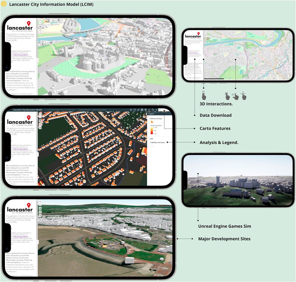
FIGURE 2. A UI interface for LCIM, solar potential of buildings, Eden Project North proposed site, and LCIM in the Unreal engine.
The CIM had its own unique identity and functionality specific to significant areas of focus within the string settlements of Heysham, Morecambe, and Lancaster.
Acquisition strategies for aerial data and remote sensing
A spatial data acquisition program was developed with Bluesky International Ltd., and stereo aerial imagery at 7.5 cm resolution was acquired from the project start (2019). LOD 2.5 buildings with a +/− of 1″(Biljecki et al., 2016), infrastructure, and features were developed using stereo pairs (2019 and 2020). Using ArcGIS and ESRI City engine computational tools, a 3D scene feature was designed and hosted on ArcGIS online, which is a cloud platform for web-based geo-information and smartphone interactions. Additional National GIS layers were incorporated, including Ordnance Survey UPRNs 5, Historic England Heritage Status, and Environment Agency LiDAR data 6. The coverage area consisted of 26 sqkm Primary Urban Areas (PUAs), although the Lancaster City Council administrative boundary covered 652 sqkm. High-quality>1 m Digital Surface Models (DSMs) were not utilized due to data licensing restrictions, which created occasional anomalies between DSM and LOD2.5 data layers. This acquisition was developed tangentially with training and feedback from the workshops.
Data licensing types and system management
The demonstrator was designed as CC-by (Creative Commons with attribution) open data so that commercial and public sector bodies could interact with the data and address the geographic data access issues faced in broader digital planning. As a region, Lancashire lacked high fidelity open data and training, and acquisition strategies identified a need for an open platform to remove barriers of accessibility and inequality. Coverage and acquisition were based on urban patterns and the LCIM would have one-way interactions. Further analytics, visualization, and scenarios could be developed on stand-alone systems, which were facilitated and demonstrated in workshops. However, the CIM was limited to a static rather than a dynamic model. Future development could incorporate dynamic data supplied by the city council and allow time-based studies and research on city metabolism, as Schaufler and Schwimmer (2020) recommended, improving the system and the transitional phase to a full UDT.
Stakeholder engagement with CIM platforms
Multiple stakeholders developed the fourth LCIM framework attribute to establish a suitable operational baseline. Two follow-up workshops and demonstrators were conducted with the city council, architecture and planning professionals, and third-sector organizations to showcase the web app and source datasets in multiple file formats as geo-packages and for CAD applications. The workshop participants experimented with VR using the Unreal Engine with walkthroughs of the LCIM. This element was embryonic but highlighted a trajectory that Flora Roumpani (2022) identified in the use of CityEngine and parametric design:
Urban modelling methods and simulations can support planning and communicating the parameters critical to balancing urban life. CityEngine would help shape decision-making by testing many different options or seeking the optimum option from a finite number of proposals. (p. 327)
In comparison with a much larger CIM project, Virtual Helsinki7, led by the City administration, the LCIM shared many system features but at a much smaller scale, budget, and with other limitations, consisting of a reality capture mesh component and a semantic (classified) model up to LOD2 as open data with building energy performance and climate analysis8. Virtual Helsinki was hosted via Cesium to create a valuable public interface without great computational demand and modelled urban environments since the 1980s. CityGML standards and VR porting were used to create Virtual Tourism with the games company Zoan through a reality capture ‘metaverse’ and all connect into an exciting digital workflow. The LCIM design can incorporate much larger functionalities and analytical workflows in future developments and shares some of the standard interaction attributes of a CIM as found in much more extensive research projects such as Helsinki’s. However, while the LCIM can be viewed on smartphones, its ability for public feedback and interaction is limited with a lack of UI for public comments and the digital data dashboards found in other research, such as the Dublin Dashboard by Maynooth University.
Results and discussion
These four areas of a reproducible framework for a CIM with UDT transition reveal several challenges and limitations resulting from the LCIM research. The resulting LCIM demonstrator can be viewed here: https://gd3d.maps.arcgis.com/apps/webappviewer3d/index.html?id=53823deb3a194240a5f293af3d149d3b.
A CIM to UDT framework for areas 1 and 2 is entirely limited if the data is not open and transparent. In the course of designing the LCIM, we analyzed various actors and 3D City model providers in the UK to understand their public and commercial models. The availability of UK 3D open data is currently limited with various commercial actors and national mapping providers offering subscription models, varied access, and paywalls. Data availability makes any CIM ambition particularly difficult if the CIM design involves 3D GIS and added costs for users in terms of training, information sharing, and integration with other datasets. As per its roadmap, the LCIM was designed as an accessible published dataset as a baseline and a vital feature of the CIM. The LCIM is currently the most extensive CC-by 3D dataset in the United Kingdom, is accessible in this paper, and forms an important milestone in establishing a CIM framework for framework attribute 2, aerial aquistion strategy. The dataset envisaged supplying a range of public and commercial sector organizations that are interested in generating insights to create parity of geo-information. Ensuring the engagement and development of the LCIM through further training and support for framework attribute 1, which was outside of the research project, is intrinsically linked to attribute 3 of the framework, the open data ambition. Such skills and challenges as found in the LCIM research project results are recognized in the UK by the Royal Town Planning Institute (RTPI, 2019) Digital Planning Manifesto 9 Area 3 for digital literacy and capacity programs for local authorities.
At a more macro level, for CIMs to become UDTs, there needs to be facilitation and improved access (cost and licensing) to allow for innovation and not just experimentation under exploratory licenses. There are nuanced factors to consider in this model, and this may not be the most suitable arrangement for others seeking to replicate this CIM. Open data is intangibly linked to research and professional skillsets in working with CIMs. As Löfgren and Webster (2020) state,
there is an assumption that data will flow readily between public and private sector actors, but in practice, the result is that the control of the design, analysis and subsequently usage will be in the hands of commercial actors... in data analytics. (p. 9)
The availability of open data is a primary factor and theme for CIM development and digital transformation, as indicated by Emine Mine Thompson et al. (2016) in the development of a CIM for the Department of Architecture and Built Environment at Northumbria University, Geo-Visualising Commercial Real Estate Markets (GV-CREM), and Virtual Newcastle Gateshead (VNG). However, the implementation and adoption of data can cause specific issues in capturing uptake and impact; as LCIM data was CC-by, there was no suitable mode for post-use analysis by commercial architecture and planning firms. This could be due to restrictions on client confidentiality and contractual obligations in live construction projects. Open data is also critical for integrating a variety of urban indicators, which create the totality of the UDT (Guerton et al., 2022). For CIMs to UDTs transitions, open data and management are critical for designing these future systems and essential in a CIM to UDT framework for attribute 3.
Recent trends for the virtualization and gamification of CIMs and planning data, that is, game design elements applied to non-game contexts (Deterding et al., 2011), are essential areas to build the socio-technical relationships of CIM platforms, planners, and the public in engagement. The current state of the art of VR/AR context for urban planning has been covered at length and highlights a critical transitional area for UDTs (Cureton, 2022). CIM civic participation has a real opportunity through smartphone interactions, a UI for public comments on proposals, and the digitization of planning notices. Consider, for example, the scenarios feature from CIMs in a project for the Town of Morrisville, a suburb of Raleigh in North Carolina, USA. Houseal Lavigne Associates utilized CityEngine to create two scenarios based on public consultancy that helped form the land-use plan. Houseal Lavigne created a web scene for consultation but also used the Unreal Engine to simulate scenarios with the residents10. Such interactive features, training, and ease of access will be critical in future CIM to UDTs and essential in framework attribute 4.
Limitations and transitions
The CIM framework and the four attributes from the resulting work did not have a clear transitionary goal toward UDTs. The project’s final output was to develop a transitional roadmap between the LCIM as a case study and a UDT. This transitional exercise was intended to show the limitations of the LCIM work and transitional phases for future research. Three sub-themes were developed: virtualization, which is the strategy and process of remote urban sensing, analytics, and interactions. Figure 3 is a comparative schematic diagram of the LCIM functionality and limitations (on the left-hand side) and the principles of a UDT (on the right-hand side). The schematic diagram is not exhaustive but is intended to remove ambiguity around the functionalities of a CIM and a UDT. CIMs and UDTs have shared, variable, and DT-only attributes in CIM to UDT transitions. For example, digital twins are intended as Cyber-Physical systems with embedded sensors. CIMs may have IoT connections in their system design, but a DT’s complexity and virtualization are intended to be much more developed and interconnected. The schematic is intended as an outcome for additional research and to prompt discussion on research challenges. This breadth and the in-depth DT functionality can be seen in the DUET project, which is a DT framework reflecting many of the attributes of the diagram applied to Athens, Pilsen, and Flanders (Raes et al., 2021). This transitional schematic diagram will inform future research work in implementing a replicable CIM framework of the four attributes of people, data, systems, and engagement.
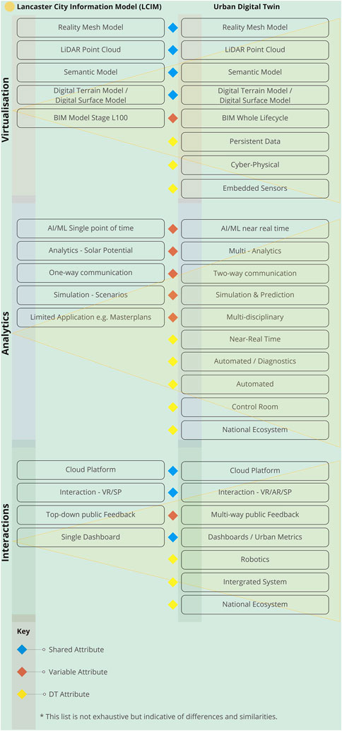
FIGURE 3. A comparative table of CIM and UDT ecosystems and performance.
Conclusion
The LCIM research demonstrator faced similar challenges as those described in broad CIM development, such as developing suitable training models, ensuring parity of access to data through open data models, and the limited functionality of a static CIM. The design of optimal data acquisition strategies for aerial imagery and LOD buildings was restricted due to costs, wider uptake, and stakeholder engagement, which was limited through the embryonic VR workflow due to time constraints. The LCIM provided a new tool for city council GIS planners, but longer-term management and the creation of dynamic features fell outside the demonstrator research. The research success of the LCIM was its open data model and point of access. The LCIM is one example of designing a CIM for civic engagement. As Wilson and Tewdwr-Jones (2022) state,
It is possible to provide people and communities with open platforms upon which to express their views and opinions about urban change to challenge unfair and unjust decisions of government and property owners, to create and design new opportunities for communities that make the technologies both fun and accessible, and to use to help develop new skills and life-enhancing opportunities. (pp. 247-248)
The LCIM has demonstrated a need for the socio-technical development of CIMs and requires the engagement of stakeholders in the schematic design of these systems, including providing suitable training to attain the new opportunities described above. In addition, this article provided a backcasting method to recognize the often-incremental nature and linear development history of CIMs and UDTs. Mapping projects, terms, and capabilities enable categorization and analysis of the state of the art. There has been much ambiguity and discussion of ‘Smart Cities,” and, for CIMs and UDTs, it is critical to provide clear schematics to differentiate the capabilities of CIMs and UDTs and how these systems will be managed through the establishment of four interlinked framework attributes. This research approach and processed-based methodology allows greater clarity, maps research challenges, and reduces the ambiguity between CIM/UDT platforms in wider non-specialist communication. UDTs offer great potential and digital transformation opportunities for the built environment, but only in a few cases has this been achieved. It is time to clarify the capability and performance of CIMs with suitable frameworks and the transitional functions of UDTs for the future.
Data availability statement
The datasets presented in this study can be found in online repositories. The names of the repository/repositories and accession number(s) can be found in the article/supplementary material.
Author contributions
PC, Co-Design Workshops; EH, CityEngine training and expertise Garsdale Design Ltd. and Imagination Lancaster.
Funding
This study was funded by UKRI Research England, E3: Beyond Imagination Project. https://www.ukri.org/what-we-offer/what-we-have-funded/research-england/expanding-excellence-in-england-e3/.
Acknowledgments
The authors would like to thank Ralph Coleman, Bluesky International Ltd., Gillian Dobson, Mark Cassidy, Paul Hatch, Maurice Brophy, Martin Chapple, and Lancaster City Council.
Conflict of interest
EH was employed by Garsdale Design Ltd. The remaining author declares that the research was conducted in the absence of any commercial or financial relationships that could be construed as a potential conflict of interest.
Publisher’s note
All claims expressed in this article are solely those of the authors and do not necessarily represent those of their affiliated organizations, or those of the publisher, editors, and reviewers. Any product that may be evaluated in this article, or claim that may be made by its manufacturer, is not guaranteed or endorsed by the publisher.
Footnotes
1https://experience.arcgis.com/experience/1673a9af082245789d17e85ee16d8dd7/page/page_2.
2https://www.marketsandmarkets.com/Market-Reports/digital-twin-market-225269522.html.
3https://3d.bk.tudelft.nl/projects/geobim/.
4https://www.lancashire.gov.uk/lancashire-insight/.
5https://www.geoplace.co.uk/addresses-streets/location-data/the-uprn.
6https://environment.data.gov.uk/DefraDataDownload/?Mode=survey.
8https://kartta.hel.fi/3d/atlas/#/.
9https://www.rtpi.org.uk/policy/2019/september/a-digital-planning-manifesto/.
10https://www.hlplanning.com/?projects=morrisville-immersive-3d-town-center-plan.
References
Badwi, I. M., Ellaithy, H. M., and Youssef, H. E. (2022). 3D-GIS parametric modelling for virtual urban simulation using CityEngine. Ann. GIS 28 (3), 325–341. doi:10.1080/19475683.2022.2037019
Basnou, C., Pino, J., Davies, C., Winkel, G., and De Vreese, R. (2020). Co-Design processes to address nature-based solutions and ecosystem services demands: The long and winding road towards inclusive urban planning. Front. Sustain. Cities 2. doi:10.3389/frsc.2020.572556
Blair, G. S. (2021). Digital twins of the natural environment. Patterns 2 (10), 100359–103899. doi:10.1016/j.patter.2021.100359
Biljecki, F., Ledoux, H., and Stoter, J. (2016). An improved LOD specification for 3D building models. Comput. Environ. Urban Syst. 59, 25–37. ISSN 0198-9715. doi:10.1016/j.compenvurbsys.2016.04.005
Cureton, P. (2022). “Augmented reality: Robotics, urbanism and the digital turn,” in The palgrave encyclopedia of urban and regional futures. Editor R Brears.
de Laat, R., and Van Berlo, L. (2011). “Integration of BIM and GIS: The development of the CityGML GeoBIM extension,” in Advances in 3D geo-information sciences. Editors T. H. Kolbe, G. König, and C. Nagel (Berlin, Heidelberg: Springer Science & Business Media), 211–225.
Deren, L., Wenbo, Y., and Zhenfeng, S. (2021). Smart city based on digital twins. Comput.Urban Sci. 1, 4. https://doi-org.ezproxy.lancs.ac.uk/10.1007/s43762-021-00005-y.
Deterding, S., Dixon, D., Khaled, R., and Nacke, L. E. (2011). “From game design elements to gamefulness: Defining “gamification”,” in Proceedings of the 15th International Academic MindTrek Conference: Envisioning Future Media Environments (MindTrek '11) (New York, NY: Association for Computing Machinery), 9–15. doi:10.1145/2181037.2181040
Dreborg, K. H. (1996). Essence of backcasting. Futures 28 (9), 813–828. doi:10.1016/S0016-3287(96)00044-4
Guerton, J., Domínguez, B., and Ezquiaga, J. M. (2022). “Urban digital twins, morphology and open data: An initial analysis in madrid,” in Annual conference proceedings of the XXVIII international seminar on urban form (Glasgow: University of Strathclyde Publishing), 847–854.
Gürdür Broo, D., and Schooling, J. (2021). Digital twins in infrastructure: Definitions, current practices, challenges and strategies. Int. J. Constr. Manag., 1–10. doi:10.1080/15623599.2021.1966980
Hämäläinen, M. (2021). Urban development with dynamic digital twins in Helsinki city. IET SmartCities 3 (4), 201–210. doi:10.1049/smc2.12015
Holmes, H., and Burgess, G. (2022). Digital exclusion and poverty in the UK: How structural inequality shapes experiences of getting online. Digital Geogr. Soc. 3, 100041. doi:10.1016/j.diggeo.2022.100041
Ketzler, B., Naserentin, V., Latino, F., Zangelidis, C., Thuvander, L., and Logg, A. (2020). Digital twins for cities: A state of the art review. Built Environ. 46 (4), 547–573. 27. doi:10.2148/benv.46.4.547
Löfgren, K., and Webster, C. W. R. (2020). The value of Big Data in government: The case of 'smart cities.'. Big Data & Soc. doi:10.1177/2053951720912775
Phdungsilp, A. (2011). Futures studies’ backcasting method used for strategic sustainable city planning. Futures 43 (7), 707–714. doi:10.1016/j.futures.2011.05.012
Raes, L., Michiels, P., Adolphi, T., Tampere, C., Dalianis, A., McAleer, S., et al. (2021). Duet: A framework for building interoperable and trusted digital twins of smart cities. IEEE Internet Comput. 26, 43–50. doi:10.1109/mic.2021.3060962
Roumpani, F. (2022). Procedural cities as active simulators for planning, Urban Plan. 7, (2) 321–329. doi:10.17645/up.v7i2.5209
Schaufler, C., and Schwimmer, E. (2020). City information modeling – An expedient tool for developing sustainable, responsive and resilient cities? IOP Conf. Ser. Earth Environ. Sci. 588, 032005. doi:10.1088/1755-1315/588/3/032005
Singleton, A., Alexiou, A., and Savani, R. (2020). Mapping the geodemographics of digital inequality in Great Britain: An integration of machine learning into small area estimation. Comput. Environ. Urban Syst. 82, 101486. doi:10.1016/j.compenvurbsys.2020.101486
Souza, L., and Bueno, C. (2022). City information modelling as a support decision tool for planning and management of cities: A systematic literature review and bibliometric analysis. Build. Environ. 207, 108403. doi:10.1016/j.buildenv.2021.108403
Thompson, E. M., Greenhalgh, P., Muldoon-Smith, K., Charlton, J., and Dolník, M. (2016). Planners in the future city: Using city information modelling to support planners as market actors. Urban Plan. 1 (1), 79–94. doi:10.17645/up.v1i1.556
Wilson, A., and Tewdwr-Jones, M. (2022). Digital participatory planning: Civic engagement, democracy, and design. Oxon; New York: Routledge.
Keywords: City Information Models (CIMs), Urban Digital Twins (UDTs), City Digital Twins (CDTs), digital transformation (DT), GeoBIM
Citation: Cureton P and Hartley E (2023) City Information Models (CIMs) as precursors for Urban Digital Twins (UDTs): A case study of Lancaster. Front. Built Environ. 9:1048510. doi: 10.3389/fbuil.2023.1048510
Received: 19 September 2022; Accepted: 27 February 2023;
Published: 22 March 2023.
Edited by:
Pablo Martinez, University of Alberta, CanadaReviewed by:
Silvana Bruno, Politecnico di Bari, ItalyYoungsoo Jung, Myongji University, Republic of Korea
Copyright © 2023 Cureton and Hartley. This is an open-access article distributed under the terms of the Creative Commons Attribution License (CC BY). The use, distribution or reproduction in other forums is permitted, provided the original author(s) and the copyright owner(s) are credited and that the original publication in this journal is cited, in accordance with accepted academic practice. No use, distribution or reproduction is permitted which does not comply with these terms.
*Correspondence: Paul Cureton, cGF1bC5jdXJldG9uQGxhbmNhc3Rlci5hYy51aw==