
94% of researchers rate our articles as excellent or good
Learn more about the work of our research integrity team to safeguard the quality of each article we publish.
Find out more
REVIEW article
Front. Astron. Space Sci., 05 March 2025
Sec. Planetary Science
Volume 12 - 2025 | https://doi.org/10.3389/fspas.2025.1485785
This article is part of the Research TopicRemote Sensing and Modelling of Planetary and Moon SurfacesView all 6 articles
 Yutong Zhang1,2
 Weiming Cheng1,2,3,4*
Landform investigation reports are fundamental datasets for ecology, geology, and geography as they record the morphological traces of planetary surface processes, which have been the focus of top journals and distinguished scholars. Investigating landforms on Earth and other planetary bodies is crucial for understanding planetary formation and geological evolution. Remote sensing techniques have proven to be powerful tools for studying terrestrial and planetary landforms, providing detailed insights into the interactions between land surfaces and both endogenic and exogenic forces and the mechanisms driving physical processes under different conditions. This study focuses on the remote sensing perspective of planetary landform investigations, highlighting recent progress in geomorphic research. Publications in top-tier journals over the last 30 years were selected for analysis. Our findings indicate that geological history and the environmental conditions conducive to the survival, growth, and daily activities of living organisms are of great concern. The United States, the European Union, China, Japan, and Canada, along with their aerospace research institutions, continue to be key research centers and play important roles all the time. Moreover, our literature survey reveals that research on planetary landforms is gaining momentum in more countries because of advancements in instrumentation and increased international collaboration. Celestial bodies that receive significant attention include planets, moons, and comets, while asteroids should receive more attention in the future. To advance our understanding of planetary landforms, higher-precision observation data and more refined simulations are essential. Continued improvements in international cooperation will be crucial for unraveling the complex geological histories within planetary landforms, contributing to our broader understanding of planetary evolution within the solar system.
Landform mapping and investigation are widely recognized as fundamental databases for resource surveys and geological research. Furthermore, landforms record the effects of interior and exterior forces of various geological activities that have left observable traces on the surface. Therefore, research on these unique features can reveal the geological evolution process and help predict probable future scenarios on Earth through comparative planetology. In accordance with these objectives, adequate knowledge of landforms on planetary bodies at different stages of formation is highly valuable. Their topographic mapping has played a crucial role in deep-space exploration engineering, supporting tasks such as landing (or sampling zone) site selection, flight navigation, path planning, and various scientific investigations on planetary geology, topographic features, and evolutionary history (Wu and Liu, 2017; Li and Wu, 2018; Geng et al., 2019; Ren et al., 2019; Fergason et al., 2020; Wu et al., 2020).
The main objective is to inform readers about recent progress in remote-sensing-based geomorphic research and provide a comprehensive understanding of key current issues. Developing detailed hypotheses on the evolution of present-day landform systems is beyond the scope of this work. Due to remote-sensing imaging characteristics, the morphology and spatial distribution patterns of planetary bodies are readily apparent. Furthermore, multiple spatial and temporal observations potentially reveal how land surfaces interact with endogenic and exogenic forces, providing promising insights into planetary geological evolution.
In this study, the intellectual background, knowledge structure, and research frontiers of the planetary landform literature, which was published from 1994–2024, were investigated. The literature was retrieved from the Web of Science (WOS), and we used CiteSpace software for bibliometric analysis. The goals of this study are as follows:
(1) To identify frontiers in planetary landform research and the evolutionary process of its core topics.
(2) To determine the significant countries and institutions actively engaged in planetary landform research.
(3) To summarize the important driving forces related to planetary landform studies.
The main contributing forces driving the development of planetary landform research were investigated, such as the most prolific institutions, leading countries, and keywords. Through cluster analysis in CiteSpace, all the keywords were categorized into diverse research topics, revealing the knowledge network in planetary landform studies. In this study, the knowledge network refers to the relationships among various aspects related to planetary landform research, including the relationships between different research topics and associations between the most prolific institutions and countries involved in this research field. Moreover, two case studies were presented to illustrate our findings from the literature survey. Studies of landforms on Mars aim to highlight the role of classic landforms as indicators in planetary evolution research (Ramsdale et al., 2019). Similarly, applications for lunar gravity models emphasize the importance of data quality and model optimization (Huang et al., 2022).
In recent years, metrology tools for literature surveys, such as CiteSpace, VOSviewer, and HistCite, have emerged. Such software programs can effectively assist in discovering research hotspots and their interrelationships and can also be used to generate intuitive and visually appealing knowledge maps. CiteSpace, developed by Dr. Chaomei Chen’s team at Drexel University, is a Java-based application (Chen and Liu, 2020). By configuring different index values, diverse types of knowledge maps can be acquired, and each map can be analyzed to extract the evolution path, research development status, key focuses, and development frontiers. Given its high practicality, CiteSpace has been widely utilized across various fields in recent years.
We focused on journal articles and reviews published over a 30-year period between 1994 and 2024. On the basis of our bibliometric analysis, we refined this extraction period more precisely. The extracted publications were published from 1994 to 1st November 2024 to obtain a more precise overview of planetary landform research.
All the publications were from the WOS, which is the most popular academic search engine. The WOS Core Collection database contains more than 100 subjects and is a trusted independent citation database. This database covers essentially all languages and documents (articles, conference papers, books, etc.) (Shao and Kim, 2022). This database is comprehensive enough to cover the targeted top-tier journals, which identified as the most representative of the literature. Our selected journals cover science, nature, and their sub-journals. Publications about planetary landforms are common in other average journals, and many landform-featured journals are also popular. In this study, we preferred to determine what top-category journals are concerned with over planetary landforms. We focused on nature, science, and their sub-journals for several reasons. First, these are globally leading academic publications with high impact factors and broad dissemination, which can quickly attract attention from various groups to our planetary landform findings. Second, they excel at interdisciplinary integration, breaking barriers between fields such as geology, physics, and biology and spurring new collaborations for our research. Third, their rigorous peer review vouches for research quality and highlights the rigor of our work. Fourth, they have long been academic benchmarks, and past landmark achievements in our field were often first published there, so we aimed to continue that tradition. By overviewing these top journals and cutting-edge research, we hope that some interesting conclusions can be drawn, which may serve as bellwethers for related researchers.
A title/abstract/keyword search was performed in the WOS database. The first keyword is related to landforms (such as landform, terrain, and geomorphology), the second keyword is related to remote sensing technology (such as remote sensing, images, and satellites), and the third keyword is related to planetary bodies in the solar system. We have tried to cover all the planetary bodies within the solar system with missions until now, and the third keyword is “Venus,” “asteroids,” “comets,” “dwarf planets,” “Neptune,” “lunar,” “Moon,” “Jupiter,” “Mars,” “Martian,” “Mercury,” “Neptune,” “Pluto,” “Saturn,” or “Uranus.”
In total, 389 publications were returned from the automated retrieval (searched on 12th November 2024), which were further reduced to 358 by identifying important themes or targets. In this process, we reviewed the titles and abstracts of all the articles to sort research sufficiently related to planetary landforms. We also focused on planetary minerals and outcrops because we recognized that they play crucial roles in shaping landforms. These local features can influence various aspects of a landform, such as its shape, structure, and distribution. Studies that use remote-sensing data only as basic maps of the study area, without analyzing typical landform features or exploring the possible mechanisms of landform evolution, may not carry as much weight. These excluded studies often focus mainly on atmospheric conditions, the solar nebula, or planetary waves, which limits the depth of understanding of the landforms. For example, the atmosphere can have a significant impact on landforms through wind erosion (Grotzinger et al., 2015a). Over time, strong winds can wear down rock formations, change the slopes of hills, and even create unique erosional landforms such as sand dunes. Furthermore, substances can be transported by the movement of the atmosphere and then condense in particular regions (Villanueva et al., 2023). Planetary waves, on the other hand, can influence tectonic activity (Fernando et al., 2022). They might cause stress variations in the planet’s crust, which, in turn, could affect the formation of faults, folds, and other structural features that are fundamental to the shaping of landforms (Stahler et al., 2022). Note that the number of screened publications is not the same as that of cited works because some works excluded in the retrieval process still deserve mentioning (e.g., those introducing the basic idea of certain algorithms).
Apart from the published journals, the academic influence of a publication is also reflected in its citation count. WOS provides powerful access to publications and citation information related to published research papers. Notably, only independent citations were considered in our analysis. WOS contains more than 90 million records and 1 billion cited references (Shao et al., 2021). The values considered were (Niu et al., 2022) C (citation, which refers to the citation frequency), CC (co-citation, which refers to the number of co-citations), and CCV (co-citation cosine coefficient, which refers to the ratio of co-citations between data (Chen, 2006a)). Additionally, several key terms need to be explained to improve our understanding of the research frontier. Using CiteSpace software, the research frontier is identified on the basis of Kleinberg’s burst-detection algorithm (Kleinberg, 2002) and extracts burst terms from titles, abstracts, descriptors, and identifiers of bibliographic records. These terms are subsequently used as labels of clusters in heterogeneous networks of terms and articles (Chen, 2006a). In this study, we refer to these terms as burst keywords. The centrality of a node is a graph-theoretical property that quantifies the importance of the node position in a network (Freeman, 1978). Nodes with high betweenness centrality tend to connect different clusters and can be used to identify and separate clusters (Girvan and Newman, 2002; Chen, 2006b). We use betweenness centrality to analyze the country, institution, and authorship to clarify the distribution and influence of each publication in planetary landform research. The literature data concerning planetary landform research were analyzed and visualized using the methods mentioned below:
(1) Publication network analysis: this provides an outline of planetary landform publications, including the number of countries, annual account dynamics (in this part, we begin with the year 1962, when the earliest paper was published), and collaborative networks of organizations, journals, and authors.
(2) Keywords analysis: keywords condense and distill the core ideas of the literature (Gurzki and Woisetschläger, 2017). By analyzing high-frequency keywords, we can quickly grasp the research hotspots and development in this field.
(3) The strongest burst keywords analysis: keywords with the strongest bursts reflect changes in the research topic and emphasize sudden changes within a period. These keywords always suggest more information than the research topic, such as the relevant policy or the attitudes of the authorities. For example, in the case of the National Aeronautics and Space Administration (NASA), the government’s policy of continuous investment in planetary exploration has led to a series of successful missions. This policy encourages scientists to pursue innovative research and provides the necessary resources for the development of advanced technologies (e.g., the Hubble Space Telescope, which has significantly advanced our understanding of the universe).
In this section, six analyses were conducted, including growth trend analysis, keyword cluster analysis, keyword burst detection, and analyses of countries/territories, institutions, journals, and authors.
As of November 2024, 358 publications on planetary landforms and remote sensing were retrieved for the final analysis. The number of annual publications is presented in Figure 1. The evolution of the number of publications can be divided into three stages according to the dates. The first stage spans from 1962–1990, when the publication outputs increased slowly and remained nearly unchanged. The earliest publication about the planetary landforms of top-tier journals within the WOS collection was published in 1962 (Salisbury, 1962). Scientists have discussed whether there is life on Mars on the basis of low-quality observations and the limited knowledge of planetary characteristics. In the second stage, from 1990–2011, the number of publications gradually increased, increasing from 10 to 143. The year 1990 marked the beginning of a new stage in space exploration with the launch of the Hubble Space Telescope (HST) was launched (Dermott and Sagan, 1995; Flasar et al., 2005; Schmidt et al., 2009). HST facilitates the identification of planetary landforms via three crucial methods. First, its high-resolution imaging captures minute surface features. Schmidt et al. (2009) utilized high-resolution images of asteroid 2 Pallas to analyze its shape and surface alterations and distinguish landforms such as mountains, canyons, and craters. Second, multiband observations help uncover diverse landform characteristics. For example, Flasar et al. (2005) used multiband data to analyze Saturn’s temperature, wind, and chemical composition, which are vital for understanding Saturnian landforms. Third, long-term monitoring allows the tracking of planets over time and the observation of dynamic landform changes such as seasons and geological activities, thus deepening our understanding of landform formation and evolution. The third stage is from 2011 to the present. Notably, within these 15 years, the number of publications accounted for half of all extracted publications. This rapid growth in the number of publications on planetary landforms has continued until now. This trend may be closely related to international attention from scholars and official governments. In addition, more than half of the top-tier journals published their first planetary landform research articles from 2011 to the present (Table 1). The fields of material science, mechanics, and physical chemistry have reached a relatively mature stage. Leveraging the knowledge and techniques from these well-established disciplines, we are now exploring and unveiling the further mysteries of deep space.
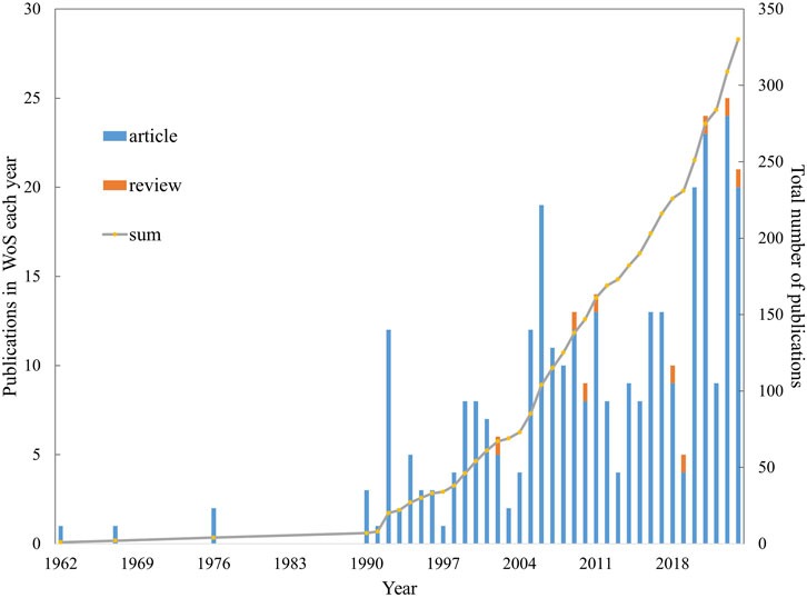
Figure 1. Annual number of publications indexed in the WOS published from 1962–2024.
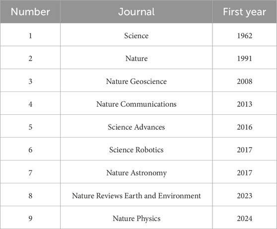
Table 1. Journal list and the first year of publication about planetary landforms.
The keywords are the core content and the briefest summary of an article (Ji and Pei, 2019), as shown in Figure 2. Keyword co-word analysis can be employed to detect research hotspots and monitor field frontiers. Using CiteSpace software, the top 50 levels of the most cited or occurred items from each slice were selected.
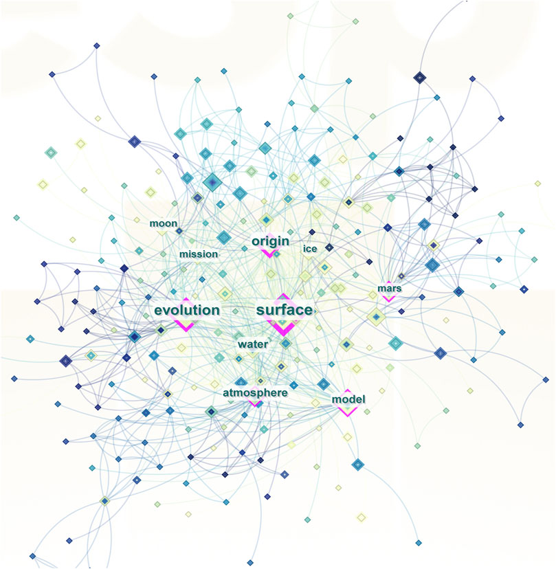
Figure 2. Keywords with centrality signs from 1994–2024.
Cluster analysis was performed on the keywords of planetary landform publications via the CiteSpace clustering function. As shown in Figure 3, there are 10 clusters, which are labeled by the log-likelihood ratio (LLR) algorithm. Keyword clusters auto-generated by CiteSpace can objectively reveal research hotspots. However, this auto-generated output might sometimes be too specific for a research field. To better understand the field of planetary landforms, these 10 clusters were classified into 2 categories as follows.
(1) Planetary bodies: this category includes planets and several important moons. The only planet that appears here is #7 Mars. Iapetus #2 and Charon #8 are the moons of Saturn and Pluto, respectively. #6 Ganymede is the largest among the four moons of Jupiter and even our solar system. The #3 moon here means not only general natural satellites (such as the Moon) but also artificial satellites. Research on moons (Figure 3) has focused on the Moon and the satellite Mariner 10.
(2) Landform-related process and relative terms: this category contains items that are more directly related to landforms. #0 water has played a crucial role in the formation of different sets of fluvial landforms, shaping the #1 surface over time (Kereszturi, 2012). They may leave layered #5 deposits and #9 mixtures. It may be composed of sediment and water and may indicate the planetary geological history (Broz et al., 2020), and we can investigate the featured landform to explore the #4 evolution of planetary.
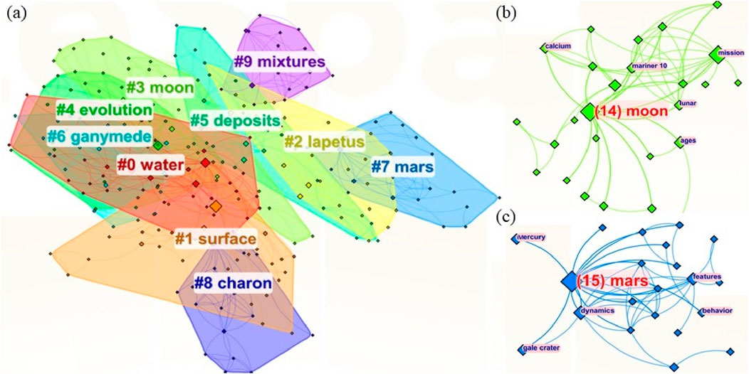
Figure 3. Keyword clusters of planetary landform research in 1994–2024. (A) Overview of all the keyword clusters. The color of the text labels is consistent with that of the node ranges. The text labels are numbered in ascending order according to the cluster size, and (B–C) details of “#3 moon” and “#7 Mars,” respectively. The numbers in parentheses represent the number of connected nodes.
By analyzing these clusters, it can be concluded that research on planetary landforms has expanded not only to include a specific planetary body but also to include a featured landform, which is always related to relevant driving forces. However, current research networks are highly concentrated within the solar system because of the limitations of current observational and analytical techniques. Although we are aware that there are landforms beyond the solar system that we cannot currently observe, our focus has been on the solar system due to available resources and capabilities.
The bursts of keywords refer to words with high frequency. These words are concepts that receive more attention within a specific period of time. By exploring keyword bursts, we identified planetary landform research hotspots and dynamics from 1994–2024. The citation history of the top 10 keywords with the strongest citation bursts is shown in Figure 4. The blue and red spots indicate the beginning and end years of the hotspot period, respectively. The color bar indicates the level of popularity (how much attention the word receives). The higher the value, the darker the blue color that is shown on the color bar. The major events in space exploration history are divided into three time periods, namely, 1994–2009, 2009–2020, and 2020–2024. These time nodes are chosen for the following reasons:
(1) Before 2010, research on planetary landforms mainly focused on Europa and the Galilean satellites, with the missions beginning in bursts and transitioning out of this hotspot situation. This suggests that research has centered on some featured bodies via photogrammetry. Images were obtained by Voyager spacecraft in the 1970s. These spacecraft conducted flybys of Jupiter and discovered Jupiter’s ring system and signs of volcanic activity on Jupiter’s moons (Prockter et al., 2002). These images revealed sparse craters and line-shaped landforms on Europa’s surface, indicating a younger terrain than that of Ganymede and Callisto, two other moons of Jupiter (Tyler, 2008). The Galileo probe, launched in 1989, conducted long-term and detailed observations of Jupiter and its moons. It flew past the Galilean satellites multiple times and provided scientists with a large amount of data. Its higher-resolution (54 m per pixel) images of Europa revealed the detailed morphology of the terrain, which strongly supports the presence of liquid water at shallow depths below the surface, either today or in the past (Tyler, 2008). These data sparked the interest of scientists, prompting further research. For example, researchers at the University of Michigan reanalyzed the data obtained by the Galileo probe in the late 1990s and found evidence suggesting possible plumes from subsurface liquid water reservoirs (Jia et al., 2018), fueling questions about Europa’s ability to support life (Kereszturi and Keszthelyi, 2013). A new mission, the Europa Clipper (Roberts et al., 2023; Becker et al., 2024), is on its way to conduct detailed scientific investigations of Europa. The probe is expected to arrive in 2030 to assess Europa’s potential to support life.
(2) During the 2010s, origin and Mars appeared as hot keywords. During this period, researchers applied statistical methods to analyze surface morphology and propose possible hypotheses to explain the origin of these featured landforms. The Mercury Surface, Space Environment, Geochemistry, and Ranging (MESSENGER) spacecraft was the first satellite to study Mercury, and data were collected from 2008–2015. Researchers utilized the data transmitted by MESSENGER to investigate the environment of Mercury, publishing a series of significant papers in top-tier journals during the 2010s (Prockter et al., 2010; Vervack et al., 2010; Neumann et al., 2013; Paral and Rankin, 2013). During this period, more countries became involved in Mars research. Martian explorations by NASA were active all the time. With past success (e.g., the 2001 Mars Odyssey mission and the Phoenix mission), spacecraft instruments were significantly improved during this period, enabling more accurate measurements and higher-level observations. The Mars Science Laboratory mission and the Mars Atmosphere and Volatile Evolution (MAVEN) mission were launched in 2011 and 2013, respectively, to study the Martian environment, either through roving or from orbit. Advancements in detector technology enabled more detailed observations and further studies of Martian terrain, such as high-resolution cameras and ground-penetrating radars. Martian exploration missions were increasingly invested in by more countries and organizations, leading to breakthrough progress during this period. For example, NASA and the European Space Agency (ESA) jointly carried out exobiology on the Mars program (ExoMars program) (Kereszturi et al., 2016) in 2010. India launched the Mars Orbiter Mission (MOM) in 2013. Since the 2020s, the surge in Mars exploration missions has continued. China’s Tianwen-1 probe, the Mars 2020 Perseverance Rover, and the Hope Mars probe were successfully launched in 2020. The Zhurong rover has been used as an important data source to investigate Mars’ surface and environment (Ding et al., 2022; Li et al., 2022a; Liu Y. et al., 2022; Liu et al., 2023). These exploration missions have provided vast amounts of data and images about Mars’ landforms, further advancing research in this area.
(3) Since the late 2010s, five keywords, namely, history, ice, regolith, moon, and constraints, have appeared in burst detection. During this period, more keywords are detected, which indicates that research on planetary landforms has been rapidly gaining recognition and development. Some interesting findings can be drawn from this situation. Planetary history was further studied with proper constraints, building upon previous work on “origin.” Keywords such as regolith reveal detailed and specific materials and spheres (Li et al., 2022a; Robin et al., 2024) because more return samples and field observations are needed for laboratory analysis and model verification (Banerdt et al., 2020; Wang et al., 2024). Moreover, ice has become the most prominent keyword among all others.
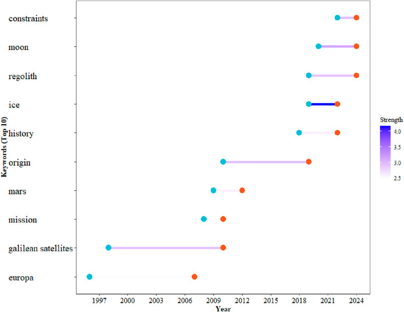
Figure 4. Top 10 keywords with the strongest bursts of planetary landform research from 1994–2024.
Planetary landform research has specific geographical trends. Research on planetary landforms is obviously influenced and restricted by the quality and sources of data, and most missions are promoted and executed by a few developed countries and organizations. As a result of the diverse geographical distributions of countries and organizations, research in this field has exhibited obvious disparities in terms of both depth and scope at the worldwide level. The country collaboration data from CiteSpace are presented in Figure 5 and Table 2. The United States published 276 articles, France published 108 articles, and Germany published 96 articles. In terms of the centrality of nodes, the highest centrality value was 0.33 for the United States. England, Japan, Italy, the Netherlands, and Belgium all had relatively high centrality values (more than 0.1, as shown in Table 3). This may have resulted from international interactions and joint exploration since the last century (Horneck et al., 2010; Ehrenfreund et al., 2012). Although most countries in this group are Western countries, Japan still engages in effective interactions with these countries through in-depth cooperation. For example, Japan is the only Asian country participating in the International Space Station, which is led by the United States. The concentration of such countries also reflects the powerful role of space organizations, such as NASA in the United States and the European Space Agency in Europe.
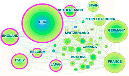
Figure 5. Collaboration network between countries for planetary landform research. The countries with high centrality values are shown by the pink line outside the circle.
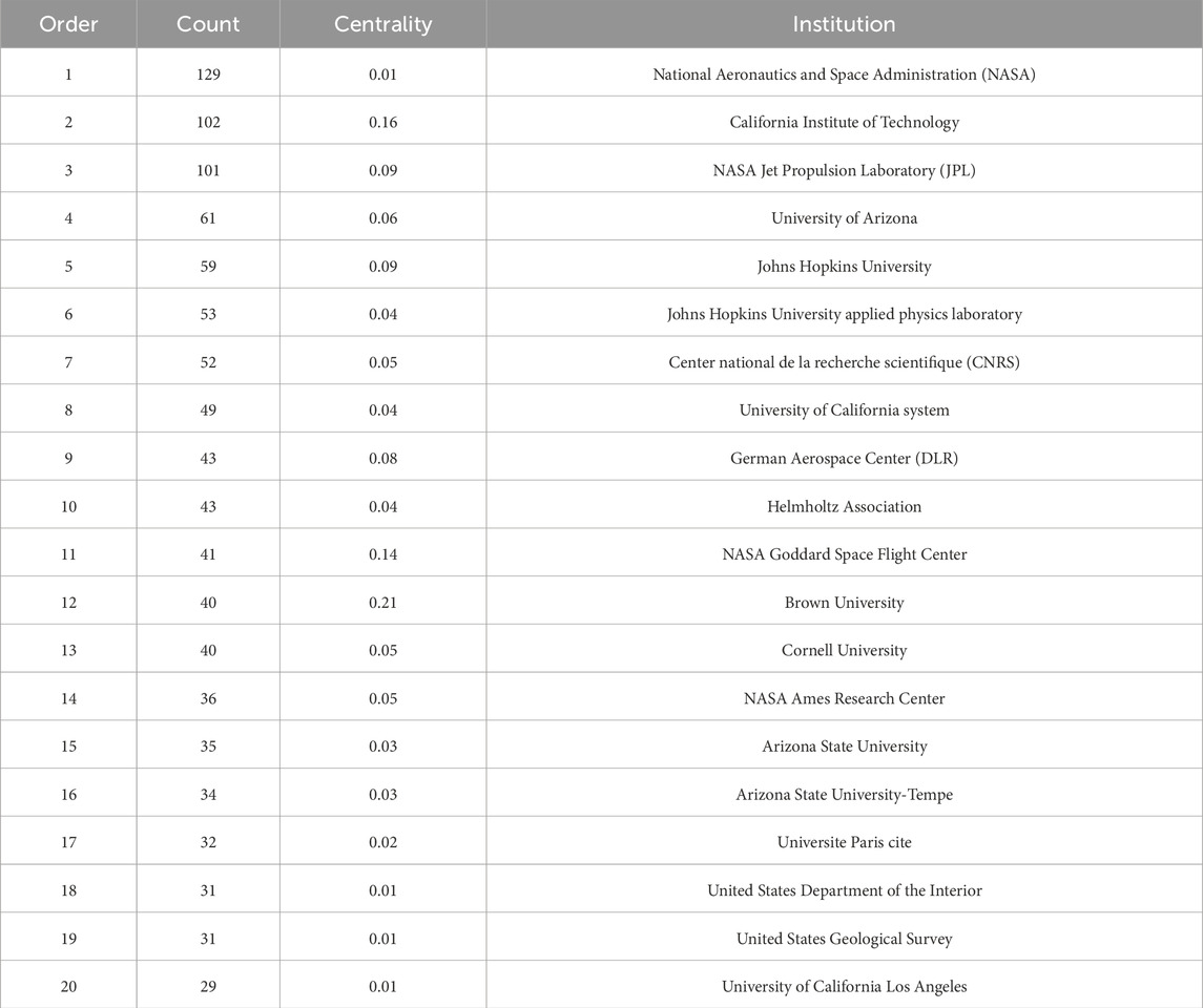
Table 2. Top 20 most productive institutions in planetary landform research.
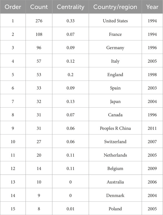
Table 3. Top 15 most productive countries in planetary landform research.
The three most productive institutions are the National Aeronautics and Space Administration, California Institute of Technology, and NASA Jet Propulsion Laboratory (JPL). The publication amounts of three institutions far exceed those of other institutions, with the figures being 156, 122, and 121, respectively. Among these institutions, the California Institute of Technology (centrality = 0.12) is both highly interrelated with other institutions and productive. Moreover, 70% of the top 10 most productive institutions are located in the USA, indicating specific geographical attributes in planetary landform research. With respect to node connection strength, institutions with strong connection strength tend to be in the same or neighboring countries. This finding is consistent with the results of the publication country analysis (Figure 5).
Co-citation analyses of journals containing planetary landform-related articles have been conducted to identify where researchers prefer to publish their findings (Azam et al., 2021). The journal co-citation network is plotted in Figure 6. The larger the node, the more important the journal is. In Figure 6, the journals with centrality values greater than 0.1 are highlighted. This dense network, with its closely connected links, indicates a strong co-citation relationship and frequent article references among these journals. The three most-cited journals are Science, Icarus, and JGR Planets, although none of these have high centrality values. Journals with high centrality (more than 0.1) include the Journal of Geophysical Research: Planets, Advances in Space Research, and Geophysical Research Letters (shown in Table 4), which are more field-specific than the journal scope of the literature covered in our survey.
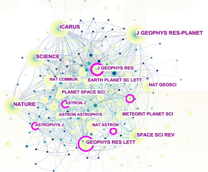
Figure 6. Journal co-citation network of planetary landform research. The journals with high centrality values are represented by the pink line outside the circle.
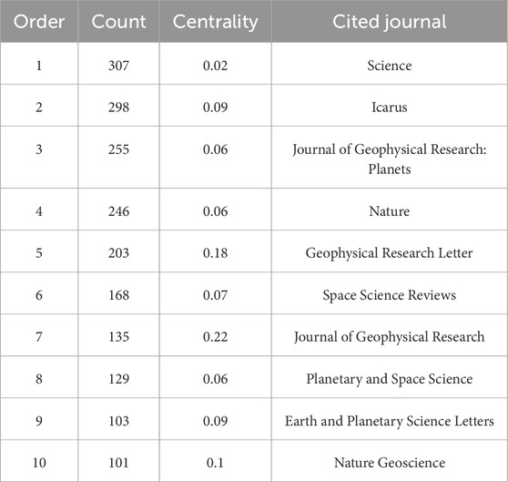
Table 4. Top 10 core journals in planetary landform research.
As analyzed above, journal network analysis reveals essential sources of research on planetary landforms. We have identified the core journals that serve as the primary sources for citation and survey, along with the links among these journals. Moreover, this network revealed the strong interdisciplinary nature of planetary landform research. This is consistent with the data and techniques we apply in our research.
A co-citation analysis of planetary landform researchers was conducted to show the collaboration network of these productive authors. This network analysis highlights the development and improvement of planetary landform studies, which depend on collaboration among relevant researchers. As shown in Figure 7, many researchers are interested in planetary landforms, and their interactions are limited to two academic communities. The core researchers in both communities are also shown in Figure 7. There has been collaborations between the researchers HEAD JW, MCCORD TB, GREELEY R, and BOTTKE WF. This academic community involves more researchers and shows more centrality than others centering on WALSH KJ. Although the two groups are in different research fields, i.e., Mars and asteroids, the younger age of WALSH KJ may account for his fewer citations. The top 10 most influential researchers are listed in Table 5, which ranks the number of citations they have gained. HEAD JW was the most influential author, with 24 citations, followed by GREELEY R, with 21 citations in the field of planetary landforms. WALSH KJ had the highest centrality, with a value of 0.32, followed by HEAD JW, with a value of 0.28. In summary, many authors tend to collaborate in groups, while some authors choose to publish articles independently. The trend of working in collaboration is inevitable and necessary.
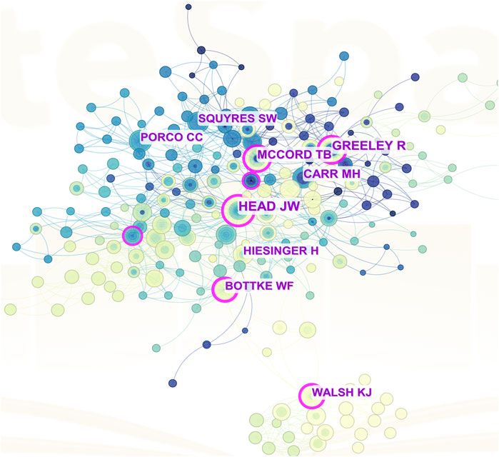
Figure 7. Author co-citation network for planetary landform research. The authors with high centrality values are shown by the pink line outside the circle.
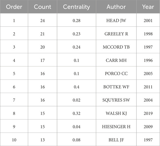
Table 5. Top 10 authors cited in papers published in Science and Nature.
The surface of Mars features diverse geomorphic features, such as craters and basins, large shield volcanoes, canyon systems, dried-up riverbeds, polar ice caps, wind-formed dunes, collapse features, lava ridges, and domes (Hargitai and Kereszturi, 2015). These features indicate different mechanisms and geological evolutions of Mars. The water process on Mars is classic and has gained research attention. We take water- and ice-related landforms as examples to investigate their possible evolution (Séjourné et al., 2019).
The various landforms on Mars are water- and ice-related landforms. Standing water may accumulate on the surface in depression terrains such as large craters (Malin and Edgett, 2003; Pondrelli et al., 2019; Salese et al., 2019; Schmidt et al., 2021; Schmidt et al., 2022), the Valles Marineris canyon network (Lucchitta et al., 1994; Warner et al., 2013; Fueten et al., 2014; Fueten et al., 2014; Al-Samir et al., 2017; Schmidt et al., 2018), and even the hemispheric-scale northern plains (Fairén et al., 2003; Di Achille and Hynek, 2010; Li et al., 2022b). A large sedimentary succession within the NW Hellas Basin rim comprises a well-preserved channel and features deposition. Principles of architectural element analysis (Miall, 1985; Holbrook, 2001) were applied to a hierarchy of bounding surfaces, revealing river processes at varying scales. Bounding-surface data and the extensive, flat topography of these sediments indicate their formation through long-term aqueous processes (alluvial and lacustrine) rather than rapid meltwater flow, episodic flooding (Salese et al., 2020), or airfall processes such as aeolian and volcaniclastic deposition (Salese et al., 2016). Nevertheless, a thermophysical numerical model of the Martian regolith revealed that Martian channels or gullies can result from debris flows triggered by geologic dry ice processes that require no liquid water (Pilorget and Forget, 2016). It is suggested that the underlying CO2 ice is released as gas fluxes during the defrosting season, destabilizing the regolith and triggering gas-lubricated debris flows, which exhibit geomorphic characteristics similar to those of Martian gullies. This type of gully is observed only on pole-facing slopes between 30° and 45° latitudes, with a less clear orientation preference above the 45° latitude (Balme et al., 2006; Harrison et al., 2014).
Water- and ice-related landforms always reflect heat-absorbing and heat-releasing processes [e.g., sublimation and liquefaction of volatiles (Changela et al., 2021)]. Scalloped and dissected mantle terrains and thermokarst-like pits and scarps may have formed through subsurface ice sublimation (Lefort et al., 2010; Dundas et al., 2018). Complex valley terrains may have resulted from a combination of ice flow and distortion and the differential sublimation of glacial ice beneath patterned soils (Mangold, 2003; Mangold, 2011). The rate of Martian ice sublimation was estimated via long-term observations of Martian analog soil and a thermal model (Johnson and Lorenz, 2000), which is approximately four times greater than expected (Douglas and Mellon, 2019). The water process is also important for the formation of polygonal cracks on Mars. Research has shown that freeze‒thaw cycles form typical thermal contraction polygons (Mellon and Michael, 1997; Seibert and Kargel, 2001; Mangold, 2005; Marchant and Head, 2007; Lefort et al., 2009; Levy et al., 2009), and desiccation leads to polygonal cracks (Grotzinger et al., 2006; El-Maarry et al., 2014; Stein et al., 2018). They are very common (Levy et al., 2009) in early Martian sedimentary layers (McLennan et al., 2005; Grotzinger et al., 2006) or at mid-to-high latitudes and are always present at large scales (Mellon and Michael, 1997; Seibert and Kargel, 2001; Mangold, 2005; Marchant and Head, 2007; Lefort et al., 2009). Nevertheless, some water-related landforms are also observed in the low-latitude area of Mars. Cracks, crusts, agglomerated particles on dune surfaces and strip-like traces, fragmented soil blocks, and polygonal ridges lying in the lowest part of the interdune depression are most likely associated with the activity of saltwater (Qin et al., 2023). Its formation was hypothesized to involve repeated frost precipitation‒thawing cycles accompanied by hydrated silica and ferric oxide concentrations triggered by dissolved salts. The hypothesis of vestigial saltwater at middle and high latitudes corroborates models of the periodic variation in the obliquity of the Mars rotation axis (Leovy, 2001; Levrard et al., 2007) and the hypothesis of the paleoclimatic evolution of polar icecaps (Levrard et al., 2007).
Alterations in water processes and other geologic activities are believed to be the mechanism for the formation of composite structures on Mars (Poulet et al., 2005; Orgel et al., 2019; Liu Y. et al., 2022). Water processes have always been considered on Mars (Malin and Edgett, 2000). Rocks with hydrated minerals were found by the Mars Science Laboratory mission rover Curiosity, which is at the foundation of Aeolis Mons, near the center of the ∼140-km-wide Gale impact crater. The northern crater walls and rims of Gale eroded into gravel and sand, and these fragments were transported toward the cater interior and sorted downstream into finer sizes via surface streams. Finally, the finest deposits filled the internal crater and accumulated along the shore of an ancient lake (Grotzinger et al., 2015b). The inter-crater plain units show more complex interactions between volcanic activity and water processes. The late Noachian (∼3.7 Ga) sedimentary plain is locally covered with lava flows, and its lithology is predominantly composed of light-toned sedimentary rocks. The geomorphic features from high-resolution images and the lithologies of sedimentary and volcanic rocks verified an intense ancient sedimentary cycle, which was followed by broad volcanic flows (Salese et al., 2016).
The diversity of Martian landforms results from various comprehensive factors, serving as a bridge between the diversity of geomorphic features and the possible history of planetary evolution. Impact events, CO2 frost processes, windblown processes, volcanic activity, and water activity on the Martian surface are always related to geomorphological phenomena. Desiccation or thermal contraction during shrinkage causes stress in the sediments, which can ultimately lead to the formation of surface cracks, even at the centimeter scale (El-Maarry et al., 2014; Qin et al., 2023). When the associated stress is greater than the tensile strength of the regolith, cracks propagate in a direction perpendicular to the maximum tensile stress, eventually forming polygonal cracks (Shorlin et al., 2000; Baker, 2001; Osterloo et al., 2008).
The Moon is the only natural satellite of the Earth. Human lunar exploration has been carried out for decades, which has yielded fruitful results, such as lunar material composition (Nozette et al., 1994; Pieters et al., 2008), gravity field (Klipstein et al., 2013; Zuber et al., 2013), and topography (Ouyang et al., 2010; Smith et al., 2010; Tooley et al., 2010; Vondrak et al., 2010). On the basis of observations by ground-based astronomical telescopes, satellite images of the lunar topography and geomorphology, and field surveys from Apollo missions, lunar tectonics on the surface can be divided into two main categories, i.e., circular structures and linear structures (Luo et al., 2017).
Linear structures extend linearly on the lunar surface. Compared with circular structures, linear structures can reflect global or regional tectonic features and even geological information. Consequently, they are important indicators of lunar evolution (Heiken et al., 1991). However, not all of them can play a similar role in lunar history; for example, the linear strips created by large-scale impact events are sedimentary structures formed by the secondary crater chains (Head, 1976).
Lobate scarps are characteristic line-shaped landforms and indicate the heat dynamics of planetary evolution. The NAC images reveal a previously undetected array of narrow, shallow troughs west of the Lee–Lincoln scarp face, which is a well-known lobate scarp. These troughs are regarded as the smallest tectonic landforms yet observed on the Moon (Watters et al., 2010). They are thin and short (<25 m in width and 100–200 m in length), with slightly steeply sloping walls and flat floors. The maximum width roughly equals the depth of the regolith, revealing the extension of the regolith layer and the underlying mare basalts. Owing to their geographic features, known lobate scarps are identified only by high-resolution images such as the Apollo panoramic camera images (Schultz, 1976), which cover parts of the equatorial zone. Recently, NAC high-resolution images (0.5–2 m per pixel) and topography derived from NAC stereo images have expanded the spatial distribution of lobate scraps to the global zone. This image shows the most detailed features of the terrain, showcasing the relief of lunar lobate scraps (Watters et al., 2010). The NAC images of previously known and newly learned lobate scarps show crosscutting relationships with small-diameter impact craters. Based on their morphology and crosscutting relationships, lobate scarps are interpreted as contracted landforms due to low-angle thrust faulting (Watters, 2003). Scientists trying to reconstruct the lunar origin wonder what this type of landform means to the Moon. The smaller lobate scarps on the Moon indicate a subtle contraction from a partially molten scenario (Solomon and Head, 1980; Stevenson, 1986). Lobate scarps appear to be <1 billion years old, thus being among the youngest tectonic landforms on the Moon (Schultz, 1976; Binder and Gunga, 1985; Watters and Schultz, 2009). The most powerful evidence for this young age is their morphological intactness, with transected meter-scale craters (Copernican age) (Watters et al., 2010) and without the superimposition of large-diameter craters (>400 m). Finally, these globally distributed lobate scarps, which are small in scale and relatively young, indicate the late-stage radial contraction of the Moon.
Lunar gravity data provide detailed information on the lunar surface and near-surface geomorphological features (e.g., the thickness of the lunar crust (Wieczorek et al., 2013) and the elastic thickness of the lunar lithosphere). These data are commonly analyzed jointly with topographic data (Wieczorek and Simons, 2007). The gravity field of the Moon has been observed since the early lunar satellites, showing the locations of mass concentrations (also known as mascons), which are related to the nearside impact basins (Muller and Sjogren, 1968).
This study used CiteSpace software to conduct a literature survey on planetary landforms from the WOS database from 1994–2024. Research on planetary landforms has grown significantly from 2011 to the present, with the number of related articles increasing to 358. This shows that more researchers are interested in this field. A large part of the research on this relationship has been concentrated in the United States, France, and Germany. Our literature survey also shows that research on planetary landforms is gaining momentum in more countries. This is due to both the advancements in instrument technology and the increase in international collaboration in this field. These two aspects have been well-demonstrated through exploration projects in recent years. Chang’e−6 features international cooperation in lunar exploration, with instruments such as the Sino-French Radon Gas Analyzer and ESA’s Lunar Surface Negative Ion Analyzer, along with contributions from Italy and Pakistan. In addition, the HAKUTO-R Mission involved the United Arab Emirates and the United States in addition to the Japan Aerospace Exploration Agency (JAXA).
Humans have always intensely longed to explore extraterrestrial space. We used CiteSpace to obtain 10 research clusters and 10 outbreak keywords in this research area, which represent what the broader scientific community considers to be key research directions on planetary landforms. In this study, we summarized three topics that receive significant interest from researchers all the time. First, the surface morphology is observed, and an in-depth exploration of its possible process is carried out to investigate planetary geological evolution. On this basis, the search for possible signs of life is conducted, and the habitability of the planet is evaluated (Domagal-Goldman et al., 2016). However, this logical order is reversed with the process of people asking questions and thinking due to curiosity. To some extent, this also explains our fascination with the planetary landforms that may have originated from water or ice dynamics.
CiteSpace analysis of the literature keywords also revealed a shift in the focus of research hotspots from planets and their satellites to asteroids (e.g., Ceres (Combe et al., 2016), Vesta (Denevi et al., 2012), and Bennu (DellaGiustina et al., 2019a; Ballouz et al., 2020; Robin et al., 2024) (Saito et al., 2006; DellaGiustina et al., 2019b)). Moreover, asteroids have already become neighboring nodes in the U.S., which is one of the hotspot centers of planetary landform research. The Hera asteroid probe (Küppers et al., 2022) of the ESA and the planned Tianwen-2 by China will both enhance our understanding of asteroids, and research on asteroids will also become more extensive in the future.
After years of development, many important achievements have been made, laying a foundation for exploring the mysteries of exoplanets. The bibliometric study of keywords and their burst history highlights the importance of scientific data and international collaboration.
The value of scientific data is embodied in its quality and quantity. The curve of annually published articles indicates that each accomplished space mission will vigorously propel the pace of scientific research on planetary studies. Moreover, multiple data types are required to verify the plausibility of the original hypothesis. The need for reliable data is common in planetary landform studies. Gravity data and gravity field models have emerged as invaluable tools for studying planetary morphology and evolution. Although direct ground-based observations, such as sample returns and high-precision seismology, remain challenging, orbital perturbation data from satellites provide high-resolution global coverage. For example, the highest-order lunar gravity model currently available is up to 1,500 degrees (Park et al., 2015), offering spatial resolutions down to ∼3.6 km, which has been extensively used to investigate the internal structure of the Moon at various scales (Andrews-Hanna et al., 2013; Wieczorek et al., 2013; Zuber et al., 2016). After the successful mission of Chang-e’ 5 with the rover and returned samples, the amount of research on the far side of the Moon has significantly increased (Liu J. et al., 2022; Luo et al., 2023). Together with in situ measurements and high-precision data, more small-scale targets can be investigated, such as boulders (Ballouz et al., 2020; Tomka et al., 2024) and the regolith (DellaGiustina et al., 2019a; Ballouz et al., 2020). In conclusion, continued advancements in data acquisition will be crucial for unraveling the complex geological histories of celestial bodies, contributing to our broader understanding of planetary evolution in the solar system.
The United States is the country with the largest number of published papers and the highest centrality value. This reflects the promoting role of international exchanges in scientific research. In view of the higher requirements for data quality in future research and the increasing number of target celestial bodies, fostering international collaboration and sharing data resources will greatly promote the development of planetary research.
In recent years, small and less space-faring countries have increasingly engaged in space exploration initiatives. Portugal established the Portuguese Space Agency (PSA) in 2019 and has been actively collaborating with the ESA. Projects such as ISTSat-1 are underway and are being applied to scientific research (Monteiro et al., 2022). In 2024, the PSA initiative funded scientific projects in space exploration, further promoting space research activities in Portugal. Ethiopia, despite economic challenges, launched its own space program with assistance from China in 2019 (Gadisa, 2023). This satellite provides valuable data for climate change research through its multispectral wide-band camera. The Ethiopian Space Science Society, established in 2004, now has over 10,000 members, 19 branches, and 100 space clubs, involving various institutions in space-related activities (Gadisa, 2023). These examples illustrate that small countries can contribute meaningfully to space exploration. Through international cooperation, investment in talent development, and the establishment of dedicated agencies, they enhance the global space exploration effort. Their participation not only benefits their own scientific and technological advancement but also enriches the diversity of the international space community. Future support and collaboration should be further encouraged to unlock greater potential in space exploration.
Some limitations to our study should be noted. First, foundational research may not always be published in top-tier journals, but it can pave the way for new research paradigms in certain planetary landform studies. As shown in Section 3.5, many other journals are always important in planetary landform research. Although our selected journals have provided valuable insights into this field of study, it is important to note that they do not encompass the entire body of research in the field. The exclusion of certain journals may have introduced a potential bias in our analysis. These biases are shown in two main aspects. In terms of research trends, some specialized journals focusing on unique geographical areas are crucial for studying landforms under local climate conditions. Omitting the research from these journals may lead to overlooking of unique findings, thus distorting our overall understanding of the global (in a planetary context) landform patterns. Second, owing to our limited subset of the available literature, the conclusions may be restricted. The landforms on different planets are unique because of different physical and chemical environments. The limited journal selection may prevent us from these differences, and the research conclusions may not be applicable to all types of geological landforms or planetary bodies. Third, using the citation count as an indicator of significance may lead to bias in highly relevant publications in a subfield, which have not gained widespread popularity. Consequently, our findings may lack comprehensiveness, as discussing all aspects of connections between many publications is not realistic. Fourth, the search terms selected in this paper have alternatives. With different search terms, the publication outputs may be skewed, such as research on asteroids. Further research can narrow the scope for a more detailed subdivision and a more exhaustive analysis of the search terms or expand the scope for more research areas. Fifth, this study merely reflects the general and fundamental state of research on planetary landforms. Considering its prevalence and complexity, future review studies could further explore the database for more in-depth analysis.
YZ: writing–original draft, conceptualization, investigation, and writing–review and editing. WC: conceptualization, funding acquisition, project administration, supervision, and writing–review and editing.
The author(s) declare that financial support was received for the research, authorship, and/or publication of this article. This article was funded by the National Natural Science Foundation of China, no. 42130110, and the B-type Strategic Priority Program of the Chinese Academy of Sciences, grant no. XDB41020400.
The authors appreciate the detailed suggestions and constructive comments from the editor and the reviewers.
The authors declare that the research was conducted in the absence of any commercial or financial relationships that could be construed as a potential conflict of interest.
All claims expressed in this article are solely those of the authors and do not necessarily represent those of their affiliated organizations, or those of the publisher, the editors and the reviewers. Any product that may be evaluated in this article, or claim that may be made by its manufacturer, is not guaranteed or endorsed by the publisher.
Al-Samir, M., Nabhan, S., Fritz, J., Winkler, A., Bishop, J. L., Gross, C., et al. (2017). The paleolacustrine evolution of Juventae Chasma and Maja Valles and its implications for the formation of interior layered deposits on Mars. Icarus 292, 125–143. doi:10.1016/j.icarus.2016.12.023
Andrews-Hanna, J. C., Asmar, S. W., Head, J. W., Kiefer, W. S., Konopliv, A. S., Lemoine, F. G., et al. (2013). Ancient igneous intrusions and early expansion of the moon revealed by GRAIL gravity gradiometry. Science 339, 675–678. doi:10.1126/science.1231753
Azam, A., Ahmed, A., Kamran, M. S., Hai, L., Zhang, Z., and Ali, A. (2021). Knowledge structuring for enhancing mechanical energy harvesting (MEH): an in-depth review from 2000 to 2020 using CiteSpace. Renew. Sustain. Energy Rev. 150, 111460. doi:10.1016/j.rser.2021.111460
Ballouz, R.-L., Walsh, K. J., Barnouin, O. S., DellaGiustina, D. N., Asad, M. A., Jawin, E. R., et al. (2020). Bennu’s near-Earth lifetime of 1.75 million years inferred from craters on its boulders. Nature 587, 205–209. doi:10.1038/s41586-020-2846-z
Balme, M., Mangold, N., Baratoux, D., Costard, F., Gosselin, M., Masson, P., et al. (2006). Orientation and distribution of recent gullies in the southern hemisphere of mars: observations from high resolution stereo camera/mars express (HRSC/MEX) and mars orbiter camera/mars global surveyor (MOC/MGS) data. J. Geophys. Res. 111, E05001. doi:10.1029/2005je002607
Banerdt, W. B., Smrekar, S. E., Banfield, D., Giardini, D., Golombek, M., Johnson, C. L., et al. (2020). Initial results from the InSight mission on Mars. Nat. Geosci. 13, 183–189. doi:10.1038/s41561-020-0544-y
Becker, T. M., Zolotov, M. Y., Gudipati, M. S., Soderblom, J. M., McGrath, M. A., Henderson, B. L., et al. (2024). Exploring the composition of Europa with the upcoming Europa clipper mission. Space Sci. Rev. 220, 49. doi:10.1007/s11214-024-01069-y
Binder, A. B., and Gunga, H.-C. (1985). Young thrust-fault scarps in the highlands: evidence for an initially totally molten moon. Icarus 63, 421–441. doi:10.1016/0019-1035(85)90055-7
Broz, P., Kryza, O., Wilson, L., Conway, S. J., Hauber, E., Mazzini, A., et al. (2020). Experimental evidence for lava-like mud flows under Martian surface conditions. Nat. Geosci. 13, 403-407. doi:10.1038/s41561-020-0577-2
Changela, H. G., Chatzitheodoridis, E., Antunes, A., Beaty, D., Bouw, K., Bridges, J. C., et al. (2021). Mars: new insights and unresolved questions. Int. J. Astrobiol. 20, 394–426. doi:10.1017/S1473550421000276
Chen, C. (2006a). CiteSpace II: detecting and visualizing emerging trends and transient patterns in scientific literature. J. Am. Soc. Inf. Sci. Technol. 57, 359–377. doi:10.1002/asi.20317
Chen, C. (2006b). CiteSpace II: detecting and visualizing emerging trends and transient patterns in scientific literature. J. Am. Soc. Inf. Sci. Technol. 57, 359–377. doi:10.1002/asi.20317
Chen, X., and Liu, Y. (2020). Visualization analysis of high-speed railway research based on CiteSpace. Transp. Policy 85, 1–17. doi:10.1016/j.tranpol.2019.10.004
Combe, J.-P., McCord, T. B., Tosi, F., Ammannito, E., Carrozzo, F. G., De Sanctis, M. C., et al. (2016). Detection of local H2O exposed at the surface of Ceres. Science 353, aaf3010. doi:10.1126/science.aaf3010
DellaGiustina, D. N., Emery, J. P., Golish, D. R., Rozitis, B., Bennett, C. A., Burke, K. N., et al. (2019a). Properties of rubble-pile asteroid (101955) Bennu from OSIRIS-REx imaging and thermal analysis. Nat. Astron 3, 341–351. doi:10.1038/s41550-019-0731-1
DellaGiustina, D. N., Emery, J. P., Golish, D. R., Rozitis, B., Bennett, C. A., Burke, K. N., et al. (2019b). Properties of rubble-pile asteroid (101955) Bennu from OSIRIS-REx imaging and thermal analysis. Nat. Astron 3, 341–351. doi:10.1038/s41550-019-0731-1
Denevi, B. W., Blewett, D. T., Buczkowski, D. L., Capaccioni, F., Capria, M. T., De Sanctis, M. C., et al. (2012). Pitted terrain on Vesta and implications for the presence of volatiles. Science 338, 246–249. doi:10.1126/science.1225374
Dermott, S., and Sagan, C. (1995). Tidal effects of disconnected hydrocarbon seas on titan. Nature 374, 238–240. doi:10.1038/374238a0
Di Achille, G., and Hynek, B. M. (2010). Ancient ocean on Mars supported by global distribution of deltas and valleys. Nat. Geosci. 3, 459–463. doi:10.1038/ngeo891
Ding, L., Zhou, R., Yu, T., Gao, H., Yang, H., Li, J., et al. (2022). Surface characteristics of the zhurong mars rover traverse at utopia planitia. Nat. Geosci. 15, 171-176. doi:10.1038/s41561-022-00905-6
Domagal-Goldman, S. D., Wright, K. E., Domagal-Goldman, S. D., Wright, K. E., Adamala, K., Arina de la Rubia, L., et al. (2016). The astrobiology primer v2.0. Astrobiology 16, 561–653. doi:10.1089/ast.2015.1460
Douglas, T. A., and Mellon, M. T. (2019). Sublimation of terrestrial permafrost and the implications for ice-loss processes on Mars. Nat. Commun. 10, 1716. doi:10.1038/s41467-019-09410-8
Dundas, C. M., Bramson, A. M., Ojha, L., Wray, J. J., Mellon, M. T., Byrne, S., et al. (2018). Exposed subsurface ice sheets in the Martian mid-latitudes. Science 359, 199–201. doi:10.1126/science.aao1619
Ehrenfreund, P., McKay, C., Rummel, J. D., Foing, B. H., Neal, C. R., Masson-Zwaan, T., et al. (2012). Toward a global space exploration program: a stepping stone approach. Adv. Space Res. 49, 2–48. doi:10.1016/j.asr.2011.09.014
El-Maarry, M. R., Watters, W., McKeown, N. K., Carter, J., Noe Dobrea, E., Bishop, J. L., et al. (2014). Potential desiccation cracks on Mars: a synthesis from modeling, analogue-field studies, and global observations. Icarus 241, 248–268. doi:10.1016/j.icarus.2014.06.033
Fairén, A. G., Dohm, J. M., Baker, V. R., De Pablo, M. A., Ruiz, J., Ferris, J. C., et al. (2003). Episodic flood inundations of the northern plains of Mars. Icarus 165, 53–67. doi:10.1016/S0019-1035(03)00144-1
Fergason, R. L., Hare, T. M., Mayer, D. P., Galuszka, D. M., Redding, B. L., Smith, E. D., et al. (2020). Mars 2020 terrain relative navigation flight product generation: digital terrain model and orthorectified image mosaic., in 51st annual lunar and planetary science conference. USA, March 16 – 20, 2020.
Fernando, B., Wojcicka, N., Maguire, R., Staehler, S. C., Stott, A. E., Ceylan, S., et al. (2022). Seismic constraints from a Mars impact experiment using InSight and Perseverance. Nat. Astron. 6, 59–64. doi:10.1038/s41550-021-01502-0
Flasar, F. M., Achterberg, R. K., Conrath, B. J., Pearl, J. C., Bjoraker, G. L., Jennings, D. E., et al. (2005). Temperatures, winds, and composition in the saturnian system. Science 307, 1247–1251. doi:10.1126/science.1105806
Freeman, L. C. (1978). Centrality in social networks conceptual clarification. Soc. Netw. 1, 215–239. doi:10.1016/0378-8733(78)90021-7
Fueten, F., Flahaut, J., Stesky, R., Hauber, E., and Rossi, A. P. (2014). Stratigraphy and mineralogy of candor mensa, west candor chasma, mars: insights into the geologic history of Valles marineris. J. Geophys. Res. Planets 119, 331–354. doi:10.1002/2013JE004557
Gadisa, D. (2023). Odyssey of Ethiopia’s space program: revealing the past and changing the future. J. Space Saf. Eng. 10, 245–255. doi:10.1016/j.jsse.2023.03.008
Geng, Y., Shao, Y., Gong, H., Brisco, B., Zhi, Y., Li, M., et al. (2019). Marine coastline polygonal ridges and surface roughness development on a salt-crusted playa: recognition by structure-from-motion photogrammetry. J. Mar. Sci. Eng. 7, 76. doi:10.3390/jmse7030076
Girvan, M., and Newman, M. E. J. (2002). Community structure in social and biological networks. Proc. Natl. Acad. Sci. 99, 7821–7826. doi:10.1073/pnas.122653799
Grotzinger, J. P., Bell, J. F., Herkenhoff, K. E., Johnson, J. B., Knoll, A. H., Mccartney, E., et al. (2006). Sedimentary textures formed by aqueous processes, Erebus crater, Meridiani Planum, Mars. Geology 34, 1085–1088. doi:10.1130/g22985a.1
Grotzinger, J. P., Gupta, S., Malin, M. C., Rubin, D. M., Schieber, J., Siebach, K., et al. (2015a). Deposition, exhumation, and paleoclimate of an ancient lake deposit, Gale crater, Mars. Science 350, AAC7575. doi:10.1126/science.aac7575
Grotzinger, J. P., Gupta, S., Malin, M. C., Rubin, D. M., Schieber, J., Siebach, K., et al. (2015b). Deposition, exhumation, and paleoclimate of an ancient lake deposit, Gale crater, Mars. Science 350, aac7575. doi:10.1126/science.aac7575
Gurzki, H., and Woisetschläger, D. M. (2017). Mapping the luxury research landscape: a bibliometric citation analysis. J. Bus. Res. 77, 147–166. doi:10.1016/j.jbusres.2016.11.009
H. Hargitai, and Á. Kereszturi (2015). Encyclopedia of planetary landforms (New York, NY: Springer New York). doi:10.1007/978-1-4614-3134-3
Harrison, T. N., Osinski, G. R., and Tornabene, L. L. (2014). “Global documentation of gullies with the mars reconnaissance orbiter context camera (CTX) and implications for their formation,” in Lunar and planetary science conference.
Head, J. W. (1976). Evidence for the sedimentary origin of imbrium sculpture and lunar basin radial texture. Moon 15, 445–462. doi:10.1007/BF00562252
Heiken, G. H., Vaniman, D. T., and French, B. M. (1991). Lunar sourcebook, A user’s guide to the moon. New York: Cambridge University Press.
Holbrook, J. (2001). Origin, genetic interrelationships, and stratigraphy over the continuum of fluvial channel-form bounding surfaces: an illustration from middle Cretaceous strata, southeastern Colorado. Sediment. Geol. 144, 179–222. doi:10.1016/S0037-0738(01)00118-X
Horneck, G., Coradini, A., Haerendel, G., Kallenrode, M.-B., Kamoun, P., Swings, J. P., et al. (2010). Towards a European vision for space exploration: recommendations of the space advisory group of the European commission. Space Policy 26, 109–112. doi:10.1016/j.spacepol.2010.02.007
Huang, Y. H., Soderblom, J. M., Minton, D. A., Hirabayashi, M., and Melosh, H. J. (2022). Bombardment history of the Moon constrained by crustal porosity. Nat. Geosci. 15, 531–535. doi:10.1038/s41561-022-00969-4
Ji, Z., and Pei, Y. (2019). Bibliographic and visualized analysis of geopolymer research and its application in heavy metal immobilization: a review. J. Environ. Manage. 231, 256–267. doi:10.1016/j.jenvman.2018.10.041
Jia, X., Kivelson, M. G., Khurana, K. K., and Kurth, W. S. (2018). Evidence of a plume on Europa from Galileo magnetic and plasma wave signatures. Nat. Astron 2, 459–464. doi:10.1038/s41550-018-0450-z
Johnson, J. B., and Lorenz, R. D. (2000). Thermophysical properties of Alaskan loess: an analog material for the Martian polar layered terrain? Geophys. Res. Lett. 27, 2769–2772. doi:10.1029/1999GL011077
Kereszturi, A. (2012). Review of wet environment types on mars with focus on duration and volumetric issues. Astrobiology 12, 586–600. doi:10.1089/ast.2011.0686
Kereszturi, A., Bradak, B., Chatzitheodoridis, E., and Ujvari, G. (2016). Indicators and methods to understand past environments from ExoMars rover drills. Orig. Life Evol. Biosphere 46, 435–454. doi:10.1007/s11084-016-9492-3
Kereszturi, A., and Keszthelyi, Z. (2013). Astrobiological implications of chaos terrains on Europa to help targeting future missions. Planet. Space Sci. 77, 74–90. doi:10.1016/j.pss.2012.08.028
Kleinberg, J. (2002). “Bursty and hierarchical structure in streams,” in Proceedings of the eighth ACM SIGKDD international conference on Knowledge discovery and data mining (New York, NY, USA: Association for Computing Machinery), 91–101. doi:10.1145/775047.775061
Klipstein, W. M., Arnold, B. W., Enzer, D. G., Ruiz, A. A., Tien, J. Y., Wang, R. T., et al. (2013). The lunar gravity ranging system for the gravity recovery and interior laboratory (GRAIL) mission. Space Sci. Rev. 178, 57–76. doi:10.1007/s11214-013-9973-x
Küppers, M., Michel, P., Fitzsimmons, A., Green, S., Lazzarin, M., Sugita, S., et al. (2022). The ESA hera mission: investigating binary asteroid (65803) didymos and the DART crater. EPSC2022-192. doi:10.5194/epsc2022-192
Lefort, A., Russell, P. S., and Thomas, N. (2010). Scalloped terrains in the peneus and amphitrites paterae region of mars as observed by HiRISE. Icarus 205, 259–268. doi:10.1016/j.icarus.2009.06.005
Lefort, A., Russell, P. S., Thomas, N., McEwen, A. S., Dundas, C. M., and Kirk, R. L. (2009). Observations of periglacial landforms in utopia planitia with the high resolution imaging science experiment (HiRISE). J. Geophys. Res. Planets 114. doi:10.1029/2008JE003264
Levrard, B., Forget, F., Montmessin, F., and Laskar, J. (2007). Recent formation and evolution of northern Martian polar layered deposits as inferred from a Global Climate Model. J. Geophys. Res. Planets 112. doi:10.1029/2006JE002772
Levy, J., Head, J., and Marchant, D. (2009). Thermal contraction crack polygons on Mars: classification, distribution, and climate implications from HiRISE observations. J. Geophys. Res. Planets 114. doi:10.1029/2008JE003273
Li, C., Zheng, Y., Wang, X., Zhang, J., Wang, Y., Chen, L., et al. (2022a). Layered subsurface in utopia basin of mars revealed by zhurong rover radar. Nature 610, 308–312. doi:10.1038/s41586-022-05147-5
Li, C., Zheng, Y., Wang, X., Zhang, J., Wang, Y., Chen, L., et al. (2022b). Layered subsurface in utopia basin of mars revealed by zhurong rover radar. Nature 610, 308–312. doi:10.1038/s41586-022-05147-5
Li, Y., and Wu, B. (2018). Analysis of rock abundance on lunar surface from orbital and descent images using automatic rock detection. J. Geophys. Res. Planets 123, 1061–1088. doi:10.1029/2017JE005496
Liu, J., Liu, B., Ren, X., Li, C., Shu, R., Guo, L., et al. (2022a). Evidence of water on the lunar surface from Chang’E-5 in-situ spectra and returned samples. Nat. Commun. 13, 3119. doi:10.1038/s41467-022-30807-5
Liu, J., Qin, X., Ren, X., Wang, X., Sun, Y., Zeng, X., et al. (2023). Martian dunes indicative of wind regime shift in line with end of ice age. Nature 620, 303- 309. doi:10.1038/s41586-023-06206-1
Liu, Y., Wu, X., Zhao, Y.-Y. S., Pan, L., Wang, C., Liu, J., et al. (2022b). Zhurong reveals recent aqueous activities in Utopia Planitia, Mars. Sci. Adv. 8, eabn8555. doi:10.1126/sciadv.abn8555
Lucchitta, B. K., Isbell, N. K., and Howington-Kraus, A. (1994). Topography of Valles marineris: implications for erosional and structural history. J. Geophys. Res. Planets 99, 3783–3798. doi:10.1029/93JE03095
Luo, B., Wang, Z., Song, J., Qian, Y., He, Q., Li, Y., et al. (2023). The magmatic architecture and evolution of the Chang’e-5 lunar basalts. Nat. Geosci. 16, 301–308. doi:10.1038/s41561-023-01146-x
Luo, L., Liu, J., Zhang, L., Ji, J., and Guo, D. (2017). Research on the classification system of lunar lineaments. Yanshi Xuebao/Acta Petrol. Sin. 33, 3285–3301. doi:10.0000/8adab8adc1a74a3794a8f48ed7de6de7
Malin, M. C., and Edgett, K. S. (2000). Evidence for recent groundwater seepage and surface runoff on Mars. Science 288, 2330–2335. doi:10.1126/science.288.5475.2330
Malin, M. C., and Edgett, K. S. (2003). Evidence for persistent flow and aqueous sedimentation on early Mars. Science 302, 1931–1934. doi:10.1126/science.1090544
Mangold, N. (2003). Geomorphic analysis of lobate debris aprons on Mars at Mars Orbiter Camera scale: evidence for ice sublimation initiated by fractures. J. Geophys. Res. Planets 108. doi:10.1029/2002JE001885
Mangold, N. (2005). High latitude patterned grounds on Mars: classification, distribution and climatic control. Icarus 174, 336–359. doi:10.1016/j.icarus.2004.07.030
Mangold, N. (2011). Ice sublimation as a geomorphic process: a planetary perspective. Geomorphology 126, 1–17. doi:10.1016/j.geomorph.2010.11.009
Marchant, D., and Head, J. (2007). Antarctic Dry Valleys: microclimate zonation, variable geomorphic processes, and implications for assessing climate change on Mars. Icarus 192, 187–222. doi:10.1016/j.icarus.2007.06.018
McLennan, S. M., Bell, J. F., Calvin, W. M., Christensen, P. R., Clark, B. C., De Souza, P. A., et al. (2005). Provenance and diagenesis of the evaporite-bearing burns formation, meridiani planum, mars. Earth Planet. Sci. Lett. 240, 95–121. doi:10.1016/j.epsl.2005.09.041
Mello, T., and Michael, T. (1997). Small-scale polygonal features on Mars: seasonal thermal contraction cracks in permafrost. J. Geophys. Res. Planets 102, 25617–25628. doi:10.1029/97je02582
Miall, A. D. (1985). Architectural-element analysis: a new method of facies analysis applied to fluvial deposits. Earth-Science Rev. 22, 261–308. doi:10.1016/0012-8252(85)90001-7
Monteiro, J. P., Cunha, A., Silva, A., Fernandes, C., Neves, D., Naf, F., et al. (2022). ISTSat-1, a space-based automatic dependent surveillance-broadcast demonstration CubeSat mission. Int. J. Satell. Commun. Netw. 40, 268–293. doi:10.1002/sat.1440
Muller, P. M., and Sjogren, W. L. (1968). Mascons: lunar mass concentrations. Science 161, 680–684. doi:10.1126/science.161.3842.680
Neumann, G. A., Cavanaugh, J. F., Sun, X., Mazarico, E. M., Smith, D. E., Zuber, M. T., et al. (2013). Bright and dark polar deposits on mercury: evidence for surface volatiles. Science 339, 296–300. doi:10.1126/science.1229764
Niu, Y., Adam, M., and Hussein, H. (2022). Connecting urban green spaces with children: a scientometric analysis using CiteSpace. Land 11, 1259. doi:10.3390/land11081259
Nozette, S., Rustan, P., Pleasance, L. P., Kordas, J. F., Lewis, I. T., Park, H. S., et al. (1994). The clementine mission to the moon: scientific overview. Science 266, 1835–1839. doi:10.1126/science.266.5192.1835
Orgel, C., Hauber, E., van Gasselt, S., Reiss, D., Johnsson, A., Ramsdale, J. D., et al. (2019). Grid mapping the northern plains of mars: a new overview of recent water- and ice-related landforms in acidalia planitia. J. Geophys. Res. (Planets) 124, 454–482. doi:10.1029/2018JE005664
Osterloo, M. M., Hamilton, V. E., Bandfield, J. L., Glotch, T. D., Baldridge, A. M., Christensen, P. R., et al. (2008). Chloride-bearing materials in the southern highlands of Mars. Science 319, 1651–1654. doi:10.1126/science.1150690
Ouyang, Z., Li, C., Zou, Y., Zhang, H., Lü, C., Liu, J., et al. (2010). Primary scientific results of Chang’E-1 lunar mission. Sci. China Earth Sci. 53, 1565–1581. doi:10.1007/s11430-010-4056-2
Paral, J., and Rankin, R. (2013). Dawn–dusk asymmetry in the kelvin–helmholtz instability at mercury. Nat. Commun. 4, 1645. doi:10.1038/ncomms2676
Park, R. S., Konopliv, A. S., Yuan, D. N., Asmar, S., Watkins, M. M., Williams, J., et al. (2015). A high-resolution spherical harmonic degree 1500 lunar gravity field from the GRAIL mission, JGR plants, 2015, G41B–G01.
Pieters, C., Boardman, J., Buratti, B., Chatterjee, A., Clark, R., Glavich, T., et al. (2008). The moon mineralogy mapper (M3) on chandrayaan-1. Curr. Sci. 96.
Pilorget, C., and Forget, F. (2016). Formation of gullies on Mars by debris flows triggered by CO2 sublimation. Nat. Geosci. 9, 65–69. doi:10.1038/ngeo2619
Pondrelli, M., Rossi, A. P., Le Deit, L., Schmidt, G., Pozzobon, R., Hauber, E., et al. (2019). Groundwater control and process variability on the equatorial layered deposits of kotido crater, mars. J. Geophys. Res. Planets 124, 779–800. doi:10.1029/2018JE005656
Poulet, F., Bibring, J. P., Mustard, J. F., Gendrin, A., Mangold, N., Langevin, Y., et al. (2005). Phyllosilicates on Mars and implications for early martian climate. Nature 438, 623–627. doi:10.1038/nature04274
Prockter, L. M., Ernst, C. M., Denevi, B. W., Chapman, C. R., Head, J. W., Fassett, C. I., et al. (2010). Evidence for young volcanism on mercury from the third MESSENGER flyby. Science 329, 668–671. doi:10.1126/science.1188186
Prockter, L. M., Head III, J. W., Pappalardo, R. T., Sullivan, R. J., Clifton, A. E., Giese, B., et al. (2002). Morphology of Europan bands at high resolution: a mid-ocean ridge-type rift mechanism. J. Geophys. Res. Planets 107, 4-1-4–26. doi:10.1029/2000JE001458
Qin, X., Ren, X., Wang, X., Liu, J., Wu, H., Zeng, X., et al. (2023). Modern water at low latitudes on Mars: potential evidence from dune surfaces. Sci. Adv. 9, eadd8868. doi:10.1126/sciadv.add8868
Ramsdale, J. D., Balme, M. R., Gallagher, C., Conway, S. J., Smith, I. B., Hauber, E., et al. (2019). Grid mapping the northern plains of mars: geomorphological, radar, and water-equivalent hydrogen results from arcadia plantia. J. Geophys. Res. (Planets) 124, 504–527. doi:10.1029/2018JE005663
Ren, X., Liu, J., Li, C., Li, H., Yan, W., Wang, F., et al. (2019). A global adjustment method for photogrammetric processing of Chang’E-2 stereo images. IEEE Trans. Geoscience Remote Sens. 57, 6832–6843. doi:10.1109/TGRS.2019.2908813
Roberts, J. H., Cable, M. L., Raymond, C. A., Schroeder, D. M., Rymer, A. M., Kiefer, W. S., et al. (2023). Exploring the interior of Europa with Europa clipper, Space Sci Rev, 2806, 2448.
Robin, C. Q., Duchene, A., Murdoch, N., Vincent, J.-B., Lucchetti, A., Pajola, M., et al. (2024). Mechanical properties of rubble pile asteroids (Dimorphos, Itokawa, Ryugu, and Bennu) through surface boulder morphological analysis. Nat. Commun. 15, 6203. doi:10.1038/s41467-024-50147-w
Saito, J., Miyamoto, H., Nakamura, R., Ishiguro, M., Michikami, T., Nakamura, A. M., et al. (2006). Detailed images of asteroid 25143 itokawa from hayabusa. Science 312, 1341–1344. doi:10.1126/science.1125722
Salese, F., Ansan, V., Mangold, N., Carter, J., Ody, A., Poulet, F., et al. (2016). A sedimentary origin for intercrater plains north of the Hellas basin: implications for climate conditions and erosion rates on early Mars. J. Geophys. Res. Planets 121, 2239–2267. doi:10.1002/2016JE005039
Salese, F., McMahon, W. J., Balme, M. R., Ansan, V., Davis, J. M., and Kleinhans, M. G. (2020). Sustained fluvial deposition recorded in Mars’ Noachian stratigraphic record. Nat. Commun. 11, 2067. doi:10.1038/s41467-020-15622-0
Salese, F., Pondrelli, M., Neeseman, A., Schmidt, G., and Ori, G. G. (2019). Geological evidence of planet-wide groundwater system on mars. J. Geophys. Res. Planets 124, 374–395. doi:10.1029/2018JE005802
Schmidt, B. E., Thomas, P. C., Bauer, J. M., Li, J.-Y., McFadden, L. A., Mutchler, M. J., et al. (2009). The shape and surface variation of 2 Pallas from the Hubble space telescope. Science 326, 275–278. doi:10.1126/science.1177734
Schmidt, G., Fueten, F., Stesky, R., Flahaut, J., and Hauber, E. (2018). Geology of hebes chasma, mars: 1. Structure, stratigraphy, and mineralogy of the interior layered deposits. J. Geophys. Res. Planets 123, 2893–2919. doi:10.1029/2018JE005658
Schmidt, G., Luzzi, E., Rossi, A. P., Pondrelli, M., Apuzzo, A., and Salvini, F. (2022). Protracted hydrogeological activity in arabia terra, mars: evidence from the structure and mineralogy of the layered deposits of becquerel crater. J. Geophys. Res. Planets 127, e2022JE007320. doi:10.1029/2022JE007320
Schmidt, G., Pondrelli, M., Salese, F., Rossi, A. P., Le Deit, L., Fueten, F., et al. (2021). Depositional controls of the layered deposits of arabia terra, mars: hints from basin geometries and stratigraphic trends. J. Geophys. Res. Planets 126, e2021JE006974. doi:10.1029/2021JE006974
Seibert, N. M., and Kargel, J. S. (2001). Small-scale Martian polygonal terrain: implications for liquid surface water. Geophys. Res. Lett. 28, 899–902. doi:10.1029/2000GL012093
Séjourné, A., Costard, F., Swirad, Z. M., Łosiak, A., Bouley, S., Smith, I., et al. (2019). Grid mapping the northern plains of mars: using morphotype and distribution of ice-related landforms to understand multiple ice-rich deposits in utopia planitia. J. Geophys. Res. Planets 124, 483–503. doi:10.1029/2018JE005665
Shao, H., and Kim, G. (2022). A comprehensive review of different types of green infrastructure to mitigate urban heat islands: progress, functions, and benefits. Land 11, 1792. doi:10.3390/land11101792
Shao, H., Kim, G., Li, Q., and Newman, G. (2021). Web of science-based green infrastructure: a bibliometric analysis in CiteSpace. Land 10, 711. doi:10.3390/land10070711
Shorlin, K. A., de Bruyn, J. R., Graham, M., and Morris, S. W. (2000). Development and geometry of isotropic and directional shrinkage-crack patterns. Phys. Rev. E 61, 6950–6957. doi:10.1103/PhysRevE.61.6950
Smith, D. E., Zuber, M. T., Neumann, G. A., Lemoine, F. G., Mazarico, E., Torrence, M. H., et al. (2010). Initial observations from the lunar orbiter laser altimeter (LOLA). Geophys. Res. Lett. 37. doi:10.1029/2010GL043751
Solomon, S. C., and Head, J. W. (1980). Lunar Mascon Basins: lava filling, tectonics, and evolution of the lithosphere. Rev. Geophys. 18, 107–141. doi:10.1029/RG018i001p00107
Stahler, S. C., Mittelholz, A., Perrin, C., Kawamura, T., Kim, D., Knapmeyer, M., et al. (2022). Tectonics of cerberus fossae unveiled by marsquakes. Nat. Astron. 6, 1376-1386. doi:10.1038/s41550-022-01803-y
Stein, N., Grotzinger, J. P., Schieber, J., Mangold, N., Hallet, B., Newsom, H., et al. (2018). Desiccation cracks provide evidence of lake drying on Mars, Sutton Island member, Murray formation, Gale Crater. Geology 46, 515–518. doi:10.1130/G40005.1
Stevenson, D. J. (1986). Lunar origin: origin of the moon. W. K. Hartmann, R. J. Phillips, and G. J. Taylor, Eds. Lunar and Planetary Institute, Houston, TX. 234, 1016–1017. doi:10.1126/science.234.4779.1016.b
Tomka, R., Boazman, S., Bradák, B., Heather, D. J., Kereszturi, A., Pal, B. D., et al. (2024). Boulder distribution, circular polarization, and optical maturity: a survey of example lunar polar terrains for future landing sites. Adv. Space Res. 73, 2243–2260. doi:10.1016/j.asr.2023.10.005
Tooley, C. R., Houghton, M. B., Saylor, R. S., Peddie, C., Everett, D. F., Baker, C. L., et al. (2010). Lunar reconnaissance orbiter mission and spacecraft design. Space Sci. Rev. 150, 23–62. doi:10.1007/s11214-009-9624-4
Tyler, R. H. (2008). Strong ocean tidal flow and heating on moons of the outer planets. Nature 456, 770–772. doi:10.1038/nature07571
Vervack, R. J., McClintock, W. E., Killen, R. M., Sprague, A. L., Anderson, B. J., Burger, M. H., et al. (2010). Mercury’s complex exosphere: results from MESSENGER’s third flyby. Science 329, 672–675. doi:10.1126/science.1188572
Villanueva, G. L., Hammel, H. B., Milam, S. N., Faggi, S., Kofman, V., Roth, L., et al. (2023). Endogenous CO2 ice mixture on the surface of Europa and no detection of plume activity. Science 381, 1305–1308. doi:10.1126/science.adg4270
Vondrak, R., Keller, J., Chin, G., and Garvin, J. (2010). Lunar reconnaissance orbiter (LRO): observations for lunar exploration and science. Space Sci. Rev. 150, 7–22. doi:10.1007/s11214-010-9631-5
Wang, B.-W., Zhang, Q. W. L., Chen, Y., Zhao, W., Liu, Y., Tang, G.-Q., et al. (2024). Returned samples indicate volcanism on the Moon 120 million years ago. Science 385, 1077–1080. doi:10.1126/science.adk6635
Warner, N. H., Sowe, M., Gupta, S., Dumke, A., and Goddard, K. (2013). Fill and spill of giant lakes in the eastern Valles Marineris region of Mars. Geology 41, 675–678. doi:10.1130/G34172.1
Watters, T. R. (2003). Thrust faults along the dichotomy boundary in the eastern hemisphere of Mars. J. Geophys. Res. Planets 108. doi:10.1029/2002JE001934
Watters, T. R., Robinson, M. S., Beyer, R. A., Banks, M. E., Bell, J. F., Pritchard, M. E., et al. (2010). Evidence of recent thrust faulting on the moon revealed by the lunar reconnaissance orbiter camera. Science 329, 936–940. doi:10.1126/science.1189590
T. R. Watters, and R. A. Schultz (2009). Planetary tectonics (Cambridge: Cambridge University Press). doi:10.1017/CBO9780511691645
Wieczorek, M. A., Neumann, G. A., Nimmo, F., Kiefer, W. S., Taylor, G. J., Melosh, H. J., et al. (2013). The crust of the moon as seen by GRAIL. Science 339, 671–675. doi:10.1126/science.1231530
Wieczorek, M. A., and Simons, F. J. (2007). Minimum-variance multitaper spectral estimation on the sphere. J. Fourier Anal. Appl. 13, 665–692. doi:10.1007/s00041-006-6904-1
Wu, B., Li, F., Hu, H., Zhao, Y., Wang, Y., Xiao, P., et al. (2020). Topographic and geomorphological mapping and analysis of the Chang’E-4 landing site on the far side of the moon. Photogrammetric Eng. and Remote Sens. 86, 247–258. doi:10.14358/PERS.86.4.247
Wu, B., and Liu, W. C. (2017). Calibration of boresight offset of LROC NAC imagery for precision lunar topographic mapping. ISPRS J. Photogrammetry Remote Sens. 128, 372–387. doi:10.1016/j.isprsjprs.2017.04.012
Zuber, M. T., Smith, D. E., Neumann, G. A., Goossens, S., Andrews-Hanna, J. C., Head, J. W., et al. (2016). Gravity field of the orientale basin from the gravity recovery and interior laboratory mission. Science 354, 438–441. doi:10.1126/science.aag0519
Keywords: planetary landform, remote sensing, bibliometric analysis, mission, solar system
Citation: Zhang Y and Cheng W (2025) Progress in the study of typical planetary landforms over the past 30 years: a bibliometric analysis in CiteSpace. Front. Astron. Space Sci. 12:1485785. doi: 10.3389/fspas.2025.1485785
Received: 24 August 2024; Accepted: 10 February 2025;
Published: 05 March 2025.
Edited by:
Andrea Longobardo, National Institute of Astrophysics (INAF), ItalyReviewed by:
Akos Kereszturi, Hungarian Academy of Sciences (MTA), HungaryCopyright © 2025 Zhang and Cheng. This is an open-access article distributed under the terms of the Creative Commons Attribution License (CC BY). The use, distribution or reproduction in other forums is permitted, provided the original author(s) and the copyright owner(s) are credited and that the original publication in this journal is cited, in accordance with accepted academic practice. No use, distribution or reproduction is permitted which does not comply with these terms.
*Correspondence: Weiming Cheng, Y2hlbmd3bUBscmVpcy5hYy5jbg==
Disclaimer: All claims expressed in this article are solely those of the authors and do not necessarily represent those of their affiliated organizations, or those of the publisher, the editors and the reviewers. Any product that may be evaluated in this article or claim that may be made by its manufacturer is not guaranteed or endorsed by the publisher.
Research integrity at Frontiers
Learn more about the work of our research integrity team to safeguard the quality of each article we publish.