 Sebastijan Mrak
 Anthea J. Coster2
 Romina Nikoukar
- 1Space Weather Technology, Research, and Education Center, University of Colorado Boulder, Boulder, CO, United States
- 2Haystack Observatory Massachusetts Institute of Technology, Westford, MA, United States
- 3Institute for Scientific Research, Boston College, Boston, MA, United States
- 4Applied Physics Laboratory, Johns Hopkins University, Laurel, MD, United States
We discuss potential science investigations at mid-latitudes enabled by a modern, space-weather-grade, ground-based Radio-Frequency network of scintillation receivers which encompasses Global Navigation Satellite Systems and Beacon receivers, along with coherent radars, and leveraging radio astronomy infrastructure for space weather application. The primary scientific research addresses the controlling space weather drivers for the structuring of mid-latitude ionospheric plasma at intermediate scales (10s of meters—10s of kilometers), their relationship with larger density structures, and their impacts on the trans-ionospheric radio links. These irregularities scintillate the signals impairing the radio link integrity and the underpinning services. The suggested science investigations are currently unable to be fully accomplished because of missing high-fidelity and long-term observations at satisfactory spatial coverage. We discuss the physics responsible for the radio wave disturbances and their impacts, review the current state of knowledge based on available observations, and outline a plan for developing the necessary infrastructure by leveraging existing ground-based distributed observatories that will enable novel scientific investigations and will be synergistic with other geoscience divisions such as seismology, geology, and meteorology.
1 Introduction
Ionospheric density irregularities are the primary space weather source of RF interference on the transionospheric radio links impairing the RF signals at frequencies ≲2 GHz including GNSS positioning and navigation service and high-frequency (HF) radars and communications. These ionospheric irregularities span over several orders of magnitude in spatial scales (meters to 100s of km) making them “visible” in HF radars such as the Super Dual Auroral Radar Network (SuperDARN) (Ribeiro et al., 2012; Nishimura et al., 2021; Nishimura et al., 2022), HAM radio links (Frissell et al., 2022), ionosondes (Zabotin and Wright, 2001), VHF coherent radars (Hysell and Larsen, 2021), and GNSS links (Mrak et al., 2018; Mrak et al., 2020; Mrak et al., 2021b). These ionospheric irregularities impact the HF systems by increasing uncertainties in ionospheric reflection point and propagation direction, and by imposing rapid fluctuations in signal intensity and phase. GNSS services are impaired by these rapid signal fluctuations causing GNSS scintillation, cycle slips, and loss of lock. While climatology and occurrence of GNSS scintillation occurrence have been relatively well understood for low- and high-latitudes (e.g., Alfonsi et al., 2011; Jiao and Morton, 2015; de Oliveira Moraes et al., 2017), we do not yet have a clear understanding of GNSS scintillation-producing irregularities at mid-latitudes. It is known that mid-latitude irregularities are, on average, weak (Aarons, 1982; Kintner et al., 2007) and cause little to no impacts on ground-based GNSS services. However, weak irregularities impact GNSS Radio Occultation (RO) frequently at mid-latitudes (Watson and Pedatella, 2018) owing to highly oblique propagation geometry. The advent of new GNSS RO constellations in high inclination orbits now encounter these irregularities every orbit. Furthermore, recent observations using ground-based GNSS receivers revealed that GNSS scintillation were occasionally observed at mid-latitudes during moderate geomagnetic storms (e.g., Mrak et al., 2021a; Rodrigues et al., 2021, and discussed below). Because the world’s population primarily lives in the mid-latitudes, it is imperative to better understand the controlling drivers causing mid-latitude plasma structuring, its climatology, controlling, and geophysical drivers.
Ionospheric density irregularities refract radio waves due to changing index of refraction n, whose magnitude changes with the RF frequency f and plasma density ne. If the geometry of the radio link (distance between the irregularities and the receiver R), frequency f, and the irregularities’ spatial scale (projection in the perpendicular direction (x, y) relative to the radio waves propagation z) is
Mid-latitudes are constantly perturbed by internal and external forcing causing Medium Scale Traveling Ionospheric Disturbances (MSTIDs). The majority of these medium-scale disturbances are manifestations of gravity waves (Hernández-Pajares et al., 2006). These coherent perturbations have an impact on aided single-frequency (real-time kinematic) GNSS positioning (Timoté et al., 2020) despite that their magnitude is only a ∼0.1 TECu (1 TECu = 1016 electrons per m2), which is only a few % of the background TEC. Mid-latitude MSTIDs during geomagnetically disturbed times can reach amplitudes of
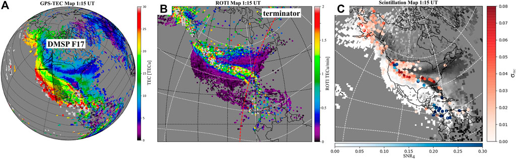
FIGURE 1. Mid-latitude plasma structuring during the 7–8 September 2017 storm at 1:15 UT on 8 September. (A) TEC map showing multiple TEC structures in the NW-SE direction with a DMSP F17 trajectory and the resolved horizontal flow. (B) ROTI maps at the same time. The red dashed line is the location of the sunset terminator. (C) Background TEC (gray) overlaid with proxy scintillation indices, phase (red), and intensity (blue).
The first reported GNSS scintillation measurements at mid-latitudes were observed from upstate New York, during a moderate storm on the 24–25 September 2001 (Ledvina et al., 2002). A recent survey for GNSS scintillation events found nine storms with average peak Dst = -131 nT, and Kp = 7−, that caused observable scintillations at mid-latitudes (Mrak et al., 2021a). The majority of events resembled extreme poleward expansion of Equatorial Plasma Bubbles (EPBs). EPBs are often recognized as the most severe space weather threat to the reliability of the GNSS services, thereby these findings are striking both in terms of space weather impacts and the underlying physical mechanisms responsible for the EPB expansion to mid-latitudes. A case study using co-located GNSS scintillation and airglow observations showed what seems to be EPB-like events causing moderate to strong GNSS scintillation reaching as far as Texas (Rodrigues et al., 2021). These observations were made using proxy observations for the conventional scintillation indices or a single Ionospheric Scintillation Monitoring Receiver (ISMR), making the observations impossible to estimate the statistical properties of the underlying intermediate-scale irregularities.
Currently, we do not have the capabilities to readily observe intermediate-scale ionospheric irregularities (10s of meters to 10s of kilometers) at mid-latitudes (we define mid-latitudes as the region between 30 ≤ |MLAT| ≤ 60). Here we focus on the American longitude sector 60°W ≤ LON
2 Discussion
We discuss observing techniques needed to observe intermediate-scale irregularities and propose a deployment strategy with operational relevance.
2.1 Observing intermediate-scale irregularities
Ionospheric RF monitoring platforms measure the signal’s power and phase at multiple frequencies and output several observing quantities (derived from measurements): scintillation indices, TEC from dual-frequency measurements, and Rate of TEC change Index (ROTI). In addition, the coherent radars measure the Bragg backscatter from irregularities at ρ = λ/2; spanning from ρ = 3 m for the ICEBEAR radar (Huyghebaert et al., 2019) to ρ = 15 m to Super Dual Auroral Radar Network (SuperDARN) (Ribeiro et al., 2012) providing high-fidelity and continuous observations of small-scale irregularities in at several longitudinal sectors of mid-latitudes in the northern hemisphere. The use of these observations could be thought of as a filter bank with varying bandwidth for observing intermediate scale irregularities as illustrated in Figure 2.
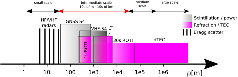
FIGURE 2. A schematic illustration of different radio remote sensing techniques measuring different bands spectra of ionospheric irregularities on the x-axis. The top line denotes ranges of scales, highlighting the intermediate scales. Gray colors indicate observables caused only by ionospheric diffraction. Magenta bands denote predominantly refractive changes in the signal phase and consequently in the TEC. The color intensity is illustrating the level of contribution to this parameter (not to scale).
Radio scintillation is normally measured using scintillation indices
Measuring all the different parameters needed to cover the intermediate-scale irregularity spectra is not strictly necessary, if relationships among S4, σΦ, and ROTI can be exploited. Carrano et al. (2019) presented an analytical derivation of the relationship between the S4 and ROTI, assuming the weak scatter theory, showing that they are related by the irregularity drift velocity v. They successfully validated this approach using 1-s ROTI and v derived from two closely spaced antennas using a separate geostationary link. Exploiting 1-s ROTI is promising at mid-latitudes because hundreds of geodetic receivers could be leveraged to estimate scintillation via S4 (Mrak et al., 2020). However, there are several caveats tied to this relationship: (1) v has to be estimated independently for each receiver station. At low-latitudes, v varies between ∼50–200 m/s, whereas at mid-latitudes it can exceed 1 km/s (Foster and Rich, 1998; Mishin and Blaunstein, 2008; song Huang et al., 2007; Nishimura et al., 2021) making this endeavor difficult. (2) the derivation assumes the known outer and inner scale of the irregularity spectrum and known irregularity axial ratio. These assumptions can be fixed at low-latitudes with high confidence because they were studied in detail there and they do not vary much. However, we do not know them well at mid-latitudes. Carrano et al. (2016) introduced an alternative approach for estimating v from σΦ and S4. This approach relies on the same assumptions as the S4-ROTI relationship, and it requires S4 and σΦ–which can be only acquired with an ISMR anyway. Additionally, it has been demonstrated that the definition of the σΦ is not valid for larger velocities v expected at mid-latitudes (Spogli et al., 2022). A more reliable alternative for estimating v is the utilization of GNSS receiver network by performing cross-correlation analysis in a space-time domain as demonstrated on several regional networks (Watson et al., 2011; Wang and Morton, 2015; Nishimura et al., 2022), with the only assumption being the separation between the ionospheric piercing points being shorter than the decorrelation length of irregularities.
The filter bank measurement approach using scintillation could be augmented to higher scales with more sensitive RF infrastructure at VHF and UHF frequencies using beacon receivers (Bernhardt et al., 2006; Carrano and Groves, 2006) and bright cosmic radio sources at frequencies between 10–90 MHz. These can be accomplished by leveraging the radio astronomy radio telescopes such as Low-Frequency Array (LOFAR) (Fallows et al., 2020), Long Wavelength Array (LWA) (Breen et al., 2008) and a simplified interferometer using two LWA antennas–Deployable Low-band Ionosphere and Transient Experiment (DLITE) (Helmboldt and Zabotin, 2022). LOFAR has in particular great potential for measuring ionospheric scintillation because it consists of many receiver stations covering a large swath of the European longitude sector freely available data though the long term storage archive (https://lta.lofar.eu/). Currently, only the COSMIC-2 constellation broadcasts continuous UHF beacon but it is under utilized for scientific exploration, and has a poor coverage over the mid-latitudes. The addition of VHF/UHF monitoring ionospheric scintillation increases direct measurements of scintillation-producing intermediate scale irregularities to
In aggregate, scintillation-producing intermediate-scale irregularities can be directly measured and characterized by ISMRs. Covering large, continental-scale, areas with ISMRs would be an expensive and logistically tedious effort. Alternative routes using inexpensive scintillation receivers (Rodrigues and Moraes, 2019), and leveraging existing geodetic receivers with 1-s data (Mrak et al., 2020) using S4-ROTI relationship (Carrano et al., 2019) can augment the high-fidelity measurements adequately if the sensor network(s) are deployed in an intelligent topology. Years of observations would be likely needed to derive empirical relationships between S4, σΦ, ROTI, and v at mid-latitudes under varying geophysical conditions.
2.2 Enabling scientific investigations
A distributed network of RF observatories for space weather, covering the entire continental United States and capable of making high-rate scintillation measurements, would enable observations of intermediate-scale ionospheric irregularities, their spatiotemporal evolution, and occurrence, and support analysis of their impacts on the GNSS services. By combining these new observations with the TEC and detrended TEC maps, from data already available from 30-s resolution receivers, these irregularities will be put into a context of larger–medium and large-scale–density structures and gradients. The new observations will enable scientific investigations related to but not limited to density irregularities associated with mid-latitude trough and related phenomena (subauroral polarization streams, Strong Thermal Emission Velocity Enhancement STEVE), storm enhanced density, mid-latitude spread F, EPBs penetrating to mid-latitudes, decaying MSTIDs. In order to understand the underlying physical mechanisms producing the intermediate-scale irregularities, employing suitable physics-based models reproducing ionospheric plasma instabilities is necessary. The modeling support is a separate problem that we cannot address. Spatially distributed and high-fidelity observations of intermediate-scale irregularities covering a whole continent will enable the quantification of:
• What is the occurrence of mid-latitude intermediate-scale irregularities during quiet and disturbed conditions?
• What are the controlling space weather parameters (solar wind, interplanetary magnetic field, penetration electric field, auroral activity), local time, and longitude dependence?
• Where do these irregularities reside with respect to the larger density structures and gradients?
• What are the physical mechanisms producing the intermediate-scale irregularities at mid-latitudes?
• Are these irregularities coupled to high- or low-latitude dynamics or are they created in situ at mid-latitudes?
2.3 Deployment strategy and data utilization
The backbone infrastructure supporting distributed ground-based observatories already exists in the US and Europe: this includes the physical sites where instrumentation is deployed and running, with established data acquisition, storage, and user access. We urge the agencies to leverage the available existing infrastructure for the space-weather-qualified instrumentation and data products described in this report. National Science Foundation (NSF) and the National Aeronautics and Space Administration (NASA) have been funding large networks of ground-based instrumentation for decades such as the UNAVCO’s GAGE facility consisting of a network of GNSS receivers proving 1-s and 30-s data. National Geodetic Survey, part of the National Oceanic and Atmospheric Agency (NOAA) operates a Continuously Operating Receiver Stations (CORS) Network (NCN) providing GNSS data at 30-s resolution. NCN aggregates data from many different providers and distributes the data from a single end-point interface. Additional investments to upgrade the available infrastructure and accommodate the deployment of additional ISMRs and beacon receivers would, in addition to enabling space weather research, increase the quality of GNSS data for a wide range of applications making the investment highly synergistic with the other fields such as seismology, geology, and meteorology.
The standardized data outputs with long-term storage should consist of: 1) RINEX files at 1-s and 30-s resolution used to compute TEC and ROTI. 2) The new network(s) with ISMRs should provide additional files with derived scintillation indices S4 and σΦ, and the decorrelation times derived from 50 to 100 Hz measurements. 3) The new networks should store raw 50–100 Hz power and phase (or I and Q) measurements for retrospective analyses, providing these data upon request using online interfaces.
Auxiliary VHF/UHF beacon receivers and LWA receivers can be deployed at hosting institutions because the operations and hardware are more involved compared to the plug-and-play nature of GNSS receiver technology. The deployment could involve higher education institutions, radio enthusiasts such as HAM radio operators, and observatories.
2.4 Relevance to research-to-operations
Space Weather Prediction Center (SWPC) currently observes ionospheric irregularities using ROTI derived from 30-s resolution data. A machine learning algorithm is then applied to these ROTI maps to identify advisory polygons–regions with potential impact on the GNSS users. The new distributed observatory measuring intermediate-scale irregularities in concert with leveraging the 1-s ROTI maps as a proxy measure of scintillation (Carrano et al., 2019) can provide SWPC with upgraded advisory polygons using the actual scintillation observation. The addition of scintillation observations from VHF receivers could potentially yield a new operational product advising HF communication disruptions.
Data availability statement
The original contributions presented in the study are included in the article/supplementary material, further inquiries can be directed to the corresponding author.
Author contributions
SM conceptualized this study and wrote the first draft of the manuscript. AC, KG, and RN contributed text to parts of the manuscript. All authors contributed to the manuscript revision, read, and approved the submitted version.
Funding
This study was partially funded by NASA grant 80NSSC21K1321 to the University of Colorado Boulder. This work was catalyzed by the NASA Living With a Star Institute on TEC and Scintillation. This research was supported by the International Space Science Institute (ISSI) in Bern and Beijing, through ISSI International Team project #511 (Multi-Scale Magnetosphere-Ionosphere-Thermosphere Interaction).
Conflict of interest
The authors declare that the research was conducted in the absence of any commercial or financial relationships that could be construed as a potential conflict of interest.
Publisher’s note
All claims expressed in this article are solely those of the authors and do not necessarily represent those of their affiliated organizations, or those of the publisher, the editors and the reviewers. Any product that may be evaluated in this article, or claim that may be made by its manufacturer, is not guaranteed or endorsed by the publisher.
References
Aarons, J. (1982). Global morphology of ionospheric scintillations. Proc. IEEE 70, 360–378. doi:10.1109/PROC.1982.12314
Alfonsi, L., Spogli, L., Franceschi, G. D., Romano, V., Aquino, M., Dodson, A., et al. (2011). Bipolar climatology of gps ionospheric scintillation at solar minimum. Radio Sci. 46. doi:10.1029/2010rs004571
Bahadur, B., and Nohutcu, M. (2020). Impact of observation sampling rate on multi-gnss static ppp performance. Surv. Rev. 0, 206–215. doi:10.1080/00396265.2019.1711346
Berdermann, J., Kriegel, M., Banyś, D., Heymann, F., Hoque, M. M., Wilken, V., et al. (2018). Ionospheric response to the x9.3 flare on 6 september 2017 and its implication for navigation services over Europe. Space weather. 16, 1604–1615. doi:10.1029/2018SW001933
Bernhardt, P., Siefring, C., and Wilkens, M. (2006). “Multi-frequency satellite beacons and receivers for ionospheric irregularity imaging,” in 2006 10th IET International Conference on Ionospheric Radio Systems and Techniques (IRST 2006) (IEEE), 198–201. doi:10.1049/cp:20060266
Booker, H. G., Ratcliffe, J. A., and Shinn, D. H. (1950). Diffraction from an irregular screen with applications to ionospheric problems. Philosophical Trans. R. Soc. Lond. Ser. A, Math. Phys. Sci. 242, 579–607. doi:10.1098/rsta.1950.0011
Breen, A. R., Fallows, R. A., Bisi, M. M., Jones, R. A., Jackson, B. V., Kojima, M., et al. (2008). The solar eruption of 2005 may 13 and its effects: Long-baseline interplanetary scintillation observations of the earth-directed coronal mass ejection. Astrophysical J. 683, L79–L82. doi:10.1086/591520
Carrano, C. S., Groves, K. M., Rino, C. L., and Doherty, P. H. (2016). A technique for inferring zonal irregularity drift from single-station gnss measurements of intensity (s4) and phase (σϕ) scintillations. Radio Sci. 51, 1263–1277. doi:10.1002/2015RS005864
Carrano, C. S., Groves, K. M., and Rino, C. L. (2019). On the relationship between the rate of change of total electron content index (ROTI), irregularity strength (C°kL), and the scintillation index (S°4). J. Geophys. Res. Space Phys. 124, 2099–2112. doi:10.1029/2018JA026353
Carrano, C. S., and Groves, K. M. (2006). The gps segment of the afrl-scinda global network and the challenges of real-time tec estimation in the equatorial ionosphere. Proc. Inst. Navigation, Natl. Tech. Meet. 2, 1036–1047.
de Oliveira Moraes, A., Costa, E., Abdu, M. A., Rodrigues, F. S., de Paula, E. R., Oliveira, K., et al. (2017). The variability of low-latitude ionospheric amplitude and phase scintillation detected by a triple-frequency gps receiver. Radio Sci. 52, 439–460. doi:10.1002/2016RS006165
Fallows, R. A., Forte, B., Astin, I., Allbrook, T., Arnold, A., Wood, A., et al. (2020). A lofar observation of ionospheric scintillation from two simultaneous travelling ionospheric disturbances. J. Space Weather Space Clim. 10, 10. doi:10.1051/swsc/2020010
Foster, J. C., and Rich, F. J. (1998). Prompt midlatitude electric field effects during severe geomagnetic storms. J. Geophys. Res. Space Phys. 103, 26367–26372. doi:10.1029/97JA03057
Frissell, N. A., Kaeppler, S. R., Sanchez, D. F., Perry, G. W., Engelke, W. D., Erickson, P. J., et al. (2022). First observations of large scale traveling ionospheric disturbances using automated amateur radio receiving networks. Geophys. Res. Lett. 49. doi:10.1029/2022GL097879
Helmboldt, J. F., and Zabotin, N. (2022). An observed trend between mid-latitudes km-scale irregularities and medium-scale traveling ionospheric disturbances. Radio Sci. 57, e2021RS007396. doi:10.1029/2021RS007396
Hernández-Pajares, M., Juan, J. M., and Sanz, J. (2006). Medium-scale traveling ionospheric disturbances affecting gps measurements: Spatial and temporal analysis. J. Geophys. Res. 111, A07S11. doi:10.1029/2005JA011474
Huyghebaert, D., Hussey, G., Vierinen, J., McWilliams, K., and St-Maurice, J. (2019). Icebear: An all-digital bistatic coded continuous-wave radar for studies of the e region of the ionosphere. Radio Sci. 54, 349–364. doi:10.1029/2018RS006747
Hysell, D. L., and Burcham, J. D. (2000). The 30-mhz radar interferometer studies of midlatitude e region irregularities. J. Geophys. Res. Space Phys. 105, 12797–12812. doi:10.1029/1999JA000411
Hysell, D. L., and Larsen, M. F. (2021). Vhf imaging radar observations and theory of banded midlatitude sporadic e ionization layers. J. Geophys. Res. Space Phys. 126. doi:10.1029/2021JA029257
Jiao, Y., and Morton, Y. T. (2015). Comparison of the effect of high-latitude and equatorial ionospheric scintillation on gps signals during the maximum of solar cycle 24. Radio Sci. 50, 886–903. doi:10.1002/2015RS005719
Kintner, P. M., Ledvina, B. M., and de Paula, E. R. (2007). Gps and ionospheric scintillations. Space weather. 5. doi:10.1029/2006SW000260
Ledvina, B. M., Makela, J. J., and Kintner, P. M. (2002). First observations of intense gps l1 amplitude scintillations at midlatitude. Geophys. Res. Lett. 29, 4-1–4-4. doi:10.1029/2002GL014770
Mishin, E., and Blaunstein, N. (2008). “Irregularities within subauroral polarization stream-related troughs and gps radio interference at midlatitudes,” in Midlatitude Ionospheric Dynamics and Disturbances. Editors P. M. Kintner, A. J. Coster, T. Fuller-Rowell, A. J. Mannucci, M. Mendillo, and R. Heelis, doi:10.1029/181GM26
Mrak, S., Semeter, J., Hirsch, M., Starr, G., Hampton, D., Varney, R. H., et al. (2018). Field-aligned gps scintillation: Multisensor data fusion. J. Geophys. Res. Space Phys. 123, 974–992. doi:10.1002/2017JA024557
Mrak, S., Semeter, J., Nishimura, T., Coster, A. J., and Groves, K. (2021a). “Space weather at mid-latitudes: Leveraging geodetic gps receivers for ionospheric scintillation science,” in 34th International Technical Meeting of the Satellite Division of The Institute of Navigation, 3910–3919. doi:10.33012/2021.18130
Mrak, S., Semeter, J., Nishimura, Y., and Coster, A. J. (2021b). Extreme low-latitude total electron content enhancement and global positioning system scintillation at dawn. Space weather. 19. doi:10.1029/2021SW002740
Mrak, S., Semeter, J., Nishimura, Y., Rodrigues, F. S., Coster, A. J., and Groves, K. (2020). Leveraging geodetic gps receivers for ionospheric scintillation science. Radio Sci. 55, 1–17. doi:10.1029/2020RS007131
Nishimura, Y., Goldstein, J., Martinis, C., Ma, Q., Li, W., Zhang, S. R., et al. (2022). Multi-scale density structures in the plasmaspheric plume during a geomagnetic storm. J. Geophys. Res. Space Phys. 127. doi:10.1029/2021JA030230
Nishimura, Y., Mrak, S., Semeter, J. L., Coster, A. J., Jayachandran, P. T., Groves, K. M., et al. (2021). Evolution of mid-latitude density irregularities and scintillation in North America during the 7–8 september 2017 storm. J. Geophys. Res. Space Phys. 126, 2–31. doi:10.1029/2021JA029192
Pi, X., Mannucci, A. J., Lindqwister, U. J., and Ho, C. M. (1997). Monitoring of global ionospheric irregularities using the worldwide gps network. Geophys. Res. Lett. 24, 2283–2286. doi:10.1029/97GL02273
Ribeiro, A. J., Ruohoniemi, J. M., Baker, J. B. H., Clausen, L. B. N., Greenwald, R. A., and Lester, M. (2012). A survey of plasma irregularities as seen by the midlatitude blackstone superdarn radar. J. Geophys. Res. Space Phys. 117. doi:10.1029/2011JA017207
Rino, C. L. (1979). A power law phase screen model for ionospheric scintillation: 1. Weak scatter. Radio Sci. 14, 1135–1145. doi:10.1029/RS014i006p01135
Rodrigues, F. S., and Moraes, A. O. (2019). Scintpi: A low-cost, easy-to-build gps ionospheric scintillation monitor for dasi studies of space weather, education, and citizen science initiatives. Earth Space Sci. 6, 1547–1560. doi:10.1029/2019EA000588
Rodrigues, F. S., Socola, J. G., Moraes, A. O., Martinis, C., and Hickey, D. A. (2021). On the properties of and ionospheric conditions associated with a mid-latitude scintillation event observed over southern United States. Space weather. 19, 1–20. doi:10.1029/2021sw002744
song Huang, C., Foster, J. C., and Sahai, Y. (2007). Significant depletions of the ionospheric plasma density at middle latitudes: A possible signature of equatorial spread f bubbles near the plasmapause. J. Geophys. Res. Space Phys. 112. doi:10.1029/2007JA012307
Spogli, L., Ghobadi, H., Cicone, A., Alfonsi, L., Cesaroni, C., Linty, N., et al. (2022). Adaptive phase detrending for gnss scintillation detection: A case study over Antarctica. IEEE Geoscience Remote Sens. Lett. 19, 1–5. doi:10.1109/LGRS.2021.3067727
Timoté, C. C., Juan, J. M., Sanz, J., González-Casado, G., Rovira-García, A., and Escudero, M. (2020). Impact of medium-scale traveling ionospheric disturbances on network real-time kinematic services: Catnet study case. J. Space Weather Space Clim. 10, 29. doi:10.1051/swsc/2020030
Wang, J., and Morton, Y. T. (2015). High-latitude ionospheric irregularity drift velocity estimation using spaced gps receiver carrier phase time–frequency analysis. IEEE Trans. Geoscience Remote Sens. 53, 6099–6113. doi:10.1109/TGRS.2015.2432014
Watson, C., Jayachandran, P. T., Spanswick, E., Donovan, E. F., and Danskin, D. W. (2011). Gps tec technique for observation of the evolution of substorm particle precipitation. J. Geophys. Res. Space Phys. 116. doi:10.1029/2010JA015732
Watson, C., and Pedatella, N. M. (2018). Climatology and characteristics of medium-scale f region ionospheric plasma irregularities observed by cosmic radio occultation receivers. J. Geophys. Res. Space Phys. 123, 8610–8630. doi:10.1029/2018JA025696
Yang, Z., Mrak, S., and Morton, Y. J. (2020). “Geomagnetic storm induced mid-latitude ionospheric plasma irregularities and their implications for gps positioning over North America: A case study,” in 2020 IEEE/ION Position, Location and Navigation Symposium (PLANS) (IEEE), 234–238. doi:10.1109/PLANS46316
Keywords: ionospheric irregularities, scintillation, GNSS, plasma turbulence, space weather
Citation: Mrak S, Coster AJ, Groves K and Nikoukar R (2023) Ground-based infrastructure for monitoring and characterizing intermediate-scale ionospheric irregularities at mid-latitudes. Front. Astron. Space Sci. 10:1091340. doi: 10.3389/fspas.2023.1091340
Received: 06 November 2022; Accepted: 06 February 2023;
Published: 16 February 2023.
Edited by:
Tzu-Wei Fang, Space Weather Prediction Center (NOAA), United StatesReviewed by:
Tibor Durgonics, University of Colorado Boulder, United StatesKshitija Deshpande, Embry–Riddle Aeronautical University, United States
Copyright © 2023 Mrak, Coster, Groves and Nikoukar. This is an open-access article distributed under the terms of the Creative Commons Attribution License (CC BY). The use, distribution or reproduction in other forums is permitted, provided the original author(s) and the copyright owner(s) are credited and that the original publication in this journal is cited, in accordance with accepted academic practice. No use, distribution or reproduction is permitted which does not comply with these terms.
*Correspondence: Sebastijan Mrak, sebastijan.mrak@colorado.edu