
95% of researchers rate our articles as excellent or good
Learn more about the work of our research integrity team to safeguard the quality of each article we publish.
Find out more
HYPOTHESIS AND THEORY article
Front. Water , 14 July 2022
Sec. Water and Human Systems
Volume 4 - 2022 | https://doi.org/10.3389/frwa.2022.800926
This article is part of the Research Topic Water Security and Sustainable Development in an Uncertain World View all 12 articles
 Xanthe K. Polaine1*
 Alan Nicol2
 Jaime Amezaga1
 Meklit Berihun3
 Mengistu Dessalegn2
 Alemseged Tamiru Haile2
Water management has followed a basin unit paradigm for several decades. This framing often inherits a pre-defined spatial and institutional boundary of analysis, one that largely fails to account for various externalities influencing water security beyond the hydrological unit. Moving away from this established basin-scale analysis, we present the concept of problemscapes, a systems approach for understanding how multiple physical and social drivers surrounding (and as part of) contextual water systems determine how they work and, ultimately, the outcomes in terms of the water security they provide. By first discussing the concept of boundaries for water paradigms, we argue that problemscapes can help us understand water security as a more dynamic and hybrid system by adapting these boundaries; enabling a clearer understanding of leverage points, interconnections and possible strategic solutions to longer-term water security challenges. We apply the method for establishing and utilizing a problemscape analysis across the Central Rift Valley, Upper Awash, and Abbay basins, as well as the capital city of Addis Ababa. The interactions in this part of Central Ethiopia are notoriously complex, with sets of critical water management issues at national and international scale, hybrid water security challenges across user communities, and contested management at different scales amidst multiple, and sometimes competing, ideologies. We show that problemscaping as an approach could support future planning decisions for long-term water security by enabling a systems perspective to emerge where complexity and connectivity between actors, institutions, and physical and social entities is considered.
In the past few decades, water discourse has been increasingly dominated by water security, gradually eclipsing the more established integrated water resource management (IWRM) paradigm (Gerlak and Mukhtarov, 2015). The roots of the IWRM paradigm go back to the recommendations of the International Water Conferences in the Mar del Plata, 1977, coming into prominence after the United Nations Rio Summit on Environment and Development in 1992 (Mukhtarov, 2008). Post Rio, IWRM became a dominant paradigm of water management (Moss and Newig, 2010), reflected in the policy frameworks of many institutions (e.g., The World Bank, 2009; OECD, 2015; UN Environment, 2018). Water security, however, drawing from some of the foundational IWRM principles began its popular uptake amongst the water resources community at the start of the twenty-first century (Lautze and Manthrithilake, 2012; Varady et al., 2021). These paradigms now compete and complement each other in water management discourse; water security addresses some IWRM gaps, but also requires combination with integrative adaptive frameworks (like IWRM) to deliver solutions (Lankford et al., 2013). This paper argues that the main difference between these two paradigms is that water security takes a more focused systems-based approach, attempting to understand the dynamic web of connected relationships and sub-systems responsible for maintaining water system resilience. However, a large hinderance is, that as the water security paradigm continues to develop, it gains density in both breadth and depth. If we are to take the water security paradigm seriously as complementary to water management frameworks, we must manage this complexity conceptually and in action. In simple terms, making thinking on water security more practicable in real-world contexts. This is the aim of the problemscape approach presented in this paper.
A generalized overview of water security is presented in its various popular definitions [e.g., Global Water Partnership, 2000; World Economic Forum, 2011; United Nations University Institute for Water Environment and Health, 2013]. These tend to share largely physical themes such as: the ability to obtain and provide water of adequate use-quality to satisfy demand; ensuring sustainable supplies under changing planetary and social development scenarios; and nourishment and protection of water for both human and environmental development. Links with other resource dependencies have also been explored such as national, climate, food, energy, and human security (Lankford et al., 2013, Chapter 2). Despite these roughly agreed generalized themes, however, what it means to achieve water security has been found to vary across disciplines and geographies (Cook and Bakker, 2012). A likely explanation for this are the sets of global differences in socio-political and cultural contexts surrounding the water systems between countries, regions, communities, and individuals. This is something currently underdeveloped in water security planning, but crucial to action in the decision-making and policy arena. Using the problemscape approach, we reframe water security as a collection of hybrid contextual factors, determined by geographic, social, cultural, institutional, and political realities. Being especially mindful of the fact that these factors are in near constant flux and, are therefore, dynamic and constantly evolving.
The hybrid contextual factors determining water security (and water “securities” given its relative meaning for many different actor-stakeholders) transcend the physical geography of catchments and connect with the political economy and ecology of wider territories, whilst being more embedded within explanatory factors including culture, politics and ideology. This creates a broader understanding of water security that includes non-water insights for water challenges. The problemscape approach that this paper presents aims to conceptualize this hybridized representation of water security, rethinking integration and problem-solving in understanding water secure systems by centering its creation on a wider meaning of context. This emphasizes the inclusion of voice, knowledge, and belief systems of local users in problem-solving and problem boundary creation. Reassociating with a problem-facing operationalization of water management rather than theory-facing and in this sense is an evolution of the problemsheds idea, as initially described by Tony Allan in 1998 and reprised by Mollinga et al. (2007).
In this paper, we present our methodology for creating and analyzing problemscapes, deriving a practical method that can (re)present a water security complexity for strategic resource planning, risk mitigation, and tackling uncertainty. We create a problemscape for Central Ethiopia, focusing on elements of the Central Rift Valley, Upper Awash, and Abbay basins, as well as the capital city of Addis Ababa. Problemscaping being the process of creating and representing this hybrid water resource complexity and weighting the relative importance of different factors in determining water security (and insecurity) outcomes. The derived problemscape captures hybrid relationships that combine problem articulation and systems analysis, questioning the appropriate boundaries in which we choose to frame water security, accepting that these are more abstract and fuzzy in complex interconnected systems. It is important to note that this approach does not arrive at an optimal single solution or recommendation, rather it seeks to define and expand problems within a water security complex (where space is only one dimension) and to enable a deeper and broader understanding of the factors critical to long-term, sustainable water planning—crucially complementary to existing water management initiatives.
The dominant unit of water management is a hard boundary—the basin boundary. As a prime example of operational water management within this physical boundary, IWRM is widely implemented and has become the guiding factor for institutional development (Jaspers, 2003). The preference of the basin unit is largely due to consideration of the impacts of human interventions on local water budget components, so regional and basin scale analysis are favored (Ponnambalam and Mousavi, 2020). An extension of this focus means that technical management issues (e.g., organizational arrangements, financing, data) are often of greater focus than social issues, with efficiency (e.g., revenue, sectoral capacity, irrigation productivity) in physical and economic terms crowding out issues of equity and justice in human development (Mukhtarov, 2008). This, in turn, leads to questions of the benefits of using the basin boundary, specifically in terms of participation and accountability in water management (Cohen and Davidson, 2015).
Within the basin boundary, indicators of management implementation are however perhaps more easily measured. For example, those outlined by UN Water and the Global Water Partnership (GWP) (2007) and in the GWP Toolbox [Global Water Partnership (GWP), 2022] for IWRM—which are commonly adopted and promoted for workable water management. Even though this is a structured approach where success is relatively identifiable, the ambiguity of indicators that currently contribute to IWRM leave room for weaker interpretations of sustainability, suppression of water needs to land-use decisions, and consistent compromise between socio-economic growth and ecological integrity (Bakker and Morinville, 2013). Additionally, in 2015, the World Water Council observed that the implementation of IWRM was entangled in technical and institutional intricacies rather than embedded in problem solving (World Water Council, 2015). Arguably, these issues are products of IWRM, and its boundaries, being somewhat static and rooted in overly spatial conceptions of the water management problématique through largely ignoring interdependencies that exist outside of the basin unit.
As a summary of this hard boundary, we question its suitability for water security planning and practice. Whilst the traditional basin unit works very well for hydrological processes, other system phenomena rarely fit this mold. Essentially, basin processes do not operate at the same scale as economic or social systems and events occurring within these systems lose relevance or prominence due to unsuitable boundaries. This can be the case for macro representation of water management as well as micro events that take place in the decision-making arena; different dynamic scales between natural and human systems mean interfaces and interactions between the respective sub-systems often misalign and there are therefore asymmetries between water-sheds, problem-sheds, and policy-sheds (Cohen and Davidson, 2015; Ponnambalam and Mousavi, 2020).
In attempting to move away from hard physical boundaries, other water management paradigms have orientated themselves around the boundaries in which systems interfering with water management exist rather than the basin unit—these can be understood as soft boundaries. The water security paradigm is an example of this; popular boundaries of water security analysis all surpass the basin scale (e.g., nation-state, supernational, and conceptual; Cook and Bakker, 2012) and the focus on interdependencies and relationships between social and physical processes means the paradigm operates within fairly dynamic and flexible water management boundaries. This is especially well-demonstrated in Lankford et al. (2013, Chapter 2) with the concept of a web of water security that employs political ecology in considerations of water independency to other interdependencies such as food, climate, energy, and equity. This concept operates with fluid international boundaries outside of the basin unit, giving an example of the extent to which food security in the UK is dependent on the water insecurity of communities in Peru or the West Bank. Whilst this creates a potentially hazardous boundless water management framing, the complexity of water security boundaries has arguably so far managed to capture the dynamic, systems-nature of the water problématique—perhaps leading to an increase in its popularity (Lautze and Manthrithilake, 2012).
As another example, socio-hydrology (e.g., Sivapalan et al., 2012) reflects interactions of processes by considering the boundaries for the non-stationarity behaviors of the two interlocking systems of socioeconomic phenomena and hydrological processes. This often includes two temporal scales: those concerning governing physical equations representing natural processes (e.g., mass balance equations, supply, demand) and those including socioeconomic systems (e.g., poverty, migration, income, education, gender, equity; Ponnambalam and Mousavi, 2020). Naturally, this means that the system boundaries and scale for socio-hydrological analysis can vary massively between studies. But what is important is that this perspective does not constrict itself to hard boundaries, instead it is the selection of suitable boundaries of processes and interactions that are of interest in a socio-hydrological analysis.
The socio-ecological systems (SES) framework takes this one step further by creating a process that is built on the co-evolution of the entanglement of social and ecological systems, including the dependencies that exist between the two. This creates a boundary of sub-systems, interactions, and processes, all existing amongst various levels of spatial, temporal, and disciplinary scale. The SES approach is specifically concerned with four core subsystems—resource systems, resource units, management systems, and users (Ostrom, 2009) with recognized second-level and deeper-level variables. Again, when applied to water resource systems, this demonstrates a water management paradigm that places itself outside of a fixed physical boundary. The concept of hydrosocial territories captures the spatially bound multi-scalar network actively and historically constructed through the interrelationship between society, technology, and water (Boelens et al., 2016). SES focuses on understanding the processes by which a particular hydrosocial territory becomes materialized, usually relying on qualitative methods and post-structuralist theory. Swyngedouw (2009) has highlighted how most socio-ecological conditions are shaped by the tension between social processes and the transformation of natural resources through a series of interlinked technologies, that can only be understood as integrating the political economy and the political ecology perspectives. Soft boundaries can therefore provide a very different framing of water security in comparison to hard boundaries.
Disadvantages of hard boundaries for water management have been discussed in literature (e.g., Warner et al., 2014; Cohen and Davidson, 2015). But the basin boundary does, however, hold some analytical advantages being the natural hydrological boundary. Water management therefore must account for a hybrid boundary between natural processes and sociological phenomenon; boundaries should account for scales of processes, interactions and problems that transcend the hydrological cycle, especially as the realities of water management occupy a complex space that is hard to navigate through physical hydrological processes alone. This is particularly important for integrating contextual and cultural issues i.e., the problems that imbue human action with specific forms of agency—including building institutions (formal and informal), setting rules, and enforcing (or not) those rules. However, in the decision-making arena these complex soft boundaries can be inaccessible to those creating integrated solutions and action with stakeholders. Water security, therefore, requires a rooting in the hard on-the-ground realities of water management including characteristics of quantity, quality, and access, amongst others, in order to avoid the danger of boundless analysis.
Moving into a more complex understanding of what the reality of water security is, the problems faced, and how they might be understood and managed, requires conceptual navigation tools. In moving between physical and conceptual, we demand more from stakeholders and decision-makers in terms of understanding and processing. In this sense, the creation of a hybrid boundary of water security could help to unpack how context-specific factors are essential to achieving water secure systems, whilst ensuring that management is orientated toward on-the-ground challenges (i.e., problems) as they are experienced by local water users in a way that is accessible to decision-makers. This does not always manifest within the basin boundary, and so the suitable boundary of management is also treated as explorative, dynamic, and flexible. The presented problemscape approach attempts to create this hybrid boundary for water management, unifying two complex elements: (i) the conceptualization of water security as an evolution of the more static and physical understandings of water management defined during the IWRM era and very much focused on per capita availability; and (ii) a wider concept of water system management involving processes and intersections between water security elements that go far beyond the basin limits and, indeed, are to some extent limitless, which is central to the intermediary idea of problemsheds, discussed further in the next section.
The problemscape concept is related to problemsheds, a navigating device for framing the contextual nature of water knowledge (Mollinga, 2020). Crucially, in the context of water management, problemsheds are a socio-political construct that have multiple physical, geographic, and socially constructed dimensions (Hanasz, 2017). Problemsheds rest on the premise that the basin unit is a narrowly water-centered framing approach to water research and policy. It encourages water research to move away from reductive disciplinary framings in order to capture the multiple dimensions of water problems (Mollinga, 2020) by using issue networks as the unit of analysis rather than the basin; treating boundaries of water management as an open, empirical question instead of a pre-defined spatial, sectoral, and analytical hydrological basin boundary (Mollinga et al., 2007). A decade earlier, Prof Tony Allan used the concept to help explain how governments in the Middle East had ameliorated demand for water to ensure domestic food security through actively importing virtual water on global markets via trade in food staples (Allan, 1998).
In transitioning from problemsheds to problemscapes we explore an evolution where the foundations of the problemshed concepts are developed to make them more accessible in decision-making interactions for water security. The specific purpose of a problemscape being to guide decision makers and stakeholders through the complexity of contextual water management by structuring dynamic and interacting problems within a suitable boundary. Through this process we co-evolve a semi-framework that allows knowledge to be integrated and translated with stakeholders, a process whose importance is stressed by Ostrom (2009). Instead of reframing problemsheds, this requires a reconceptualization of relevance to the decision-making arena, addressing the challenge of development through the structuring of complex water security problems using a systems perspective in which articulations of physical, social, and political systems map the complexity of policy directions, decision-making environments and, ultimately, outcomes for water security. This expands on the influences of water security to management and landscape development and on those involved in this problemscape. The etymology of problemscape reflects this by moving away from the context of hydrology (-sheds) and toward area and structure (-scapes), hence altering the context of the issue network from actors in a policy issue to hybrid water problem structures. Similarly to problemsheds, the problemscape is not concerned with observable rigid relationships but the drivers and networks of problems.
It is hoped that this approach can foster better planning decisions for long-term water management by helping planners and practitioners engage with complexity. By attempting to structure complexity through problemscaping, we can offer a strategic perspective for water security on-the-ground. Although the outcomes of this active research approach are still under development and critique, we present the methodology and outcomes currently being developed through research and practice in Central Ethiopia. This provides an insight to how problemscaping can be utilized in complex environments, and how it will be carried forward for planning decisions in long-term water security management.
Mollinga (2020) suggests that in beginning to define a problemshed, there are a few methods that can be adopted. The C(I)MO (context, interventions, mechanisms, and outcomes) configuration is one used by Mollinga (2020). C(I)MO explains a specific observed outcome, acknowledging that the same outcome can be created by multiple mechanisms. This is similar to the logic used in the Institutional Analysis and Development (IAD) framework (Ostrom et al., 2017) and DPSIR (driver, pressure, state, impact, response; Sun et al., 2016) method. C(I)MO, IAD, and DPSIR are all analysis tools that focus on bidirectional linear methods of contextual assessment, cumulative responsible mechanisms and drivers, and observed resultant phenomenon, as well as essentiality and causality in system interactions. The problemscape integrates some aspects of these various context-mechanism-outcome approaches; however, it differs by adopting a system approach to establishing the issue network as well as the eventual output. The problemscape methodology focuses on a process that places analysis in the center of the problemscape and works outwards. Through investigation of problem framing and constituent sub-system interactions, the process is inherently explorative for building problem situational analysis.
The problemscape methodology consists of three distinct phases (see Figure 1), put simply, firstly building the problem—and then the—scape. With the first two phases being concerned with the problematization of water security, and the last phase introducing a quasi-spatial context to the analysis. The first phase, situational analysis, is conducted through problem definition, where problems can be derived from physical, social, or ideological processes or a combination of these with other factors. The second phase describes these problems as resultant emergent behaviors of problem components and sub-systems, essentially how and why these problems exist. Describing problems as emergent behaviors of their components and sub-systems is a way to represent causality and interconnectedness within the problemscape as a depiction of a structured reality. The third phase places these interactions into an area of quasi-spatial relevance in which real decision making takes place. This creates a problemscape with both a conceptual and physical transient boundary, which is proposed to help decision makers and stakeholders' understanding of vulnerability and risk associated with uncertainties as well as provide for social and managerial insights. The creation of the problemscape hybrid boundary, or perhaps better referred to as the acknowledgment of the fluid nature of the boundary, is a key outcome for problemscaping—the recognition of the state of the boundary itself being an important insight for planners and practitioners in the water security environment.
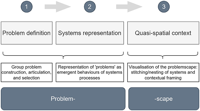
Figure 1. The problemscape methodology.
The area selected to represent the hybrid water security complex with the problemscape approach in this paper is Central Ethiopia and especially interactions between the capital city of Addis Ababa (also referred to as “Addis” in this paper) and three major surrounding basins: the Central Rift Valley (CRV), Upper Awash, and Abbay (see Figure 2). These foundational problemscape components (essentially where the outcomes for water security lie for different users—including the environment) are the roots of an entangled set of issue networks whose interactions in this area of Ethiopia are complex and increasingly political. There are overlapping water security themes between these such as land degradation, increasing agricultural activity, shrinking arable land, diminishing surface water resources, and rapid urbanization. Although the intensity of these themes varies between areas, each basin additionally has its own specific context and problems for water security. There are many ways in which the problemscape development could expand outwards from such a unit to embrace more complex water dimensions for Ethiopia, for instance at national and regional scale and suitable boundary conceptualization for a variety of stakeholders. However, in using these four areas, the water management decisions for the Central Ethiopian Complex (CEC) can be mapped in the majority under consideration of the problemscape. With regard to hybrid water security, there are some hydrological and political-ecological connections in this area of Ethiopia which makes the idea of sharing water problems between areas obvious. However, risk is also shared, and in some cases intensified, when connections are seen outside of the hydrological influences and the aim of the problemscape is to demonstrate these and present them in a way that shows the interconnectedness of water security for the CEC. The problemscape of this area is therefore imagined as the cumulative areas of connected problems associated with the influence of water security on other systems, such as the economy, livelihoods, and environment, and hence these foundational areas form a vast network of interconnected actors and events as the problemscape develops.
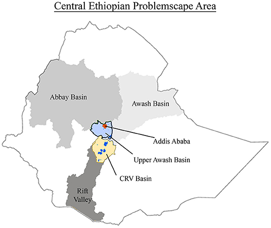
Figure 2. The Central Ethiopian Complex (CEC) area.
The problematization of water security in the CEC is the first step in defining the problemscape, and is formed through problem definition and situational analysis, integrated with emergent behavior systems construction. A problem is understood systemically in this context; a product of actor interaction that produces a gap where the reality, or future reality, of a system is different to the desired state of a system, described by Checkland (1981) as “a sense of mismatch” of actuality. However, this “gap” is a socio-political perception by the problem owner between a situation and a normative principle or objective (Thissen, 2012), meaning that the agenda of the problem owner forms the establishment and recognition of the problem. It is important to recognize this characteristic of problem definition for this iteration of the problemscape. The water security agenda of the authors introduces a subjectivity to the system, that renders it only one of many multiple realties of the problemscape for the CEC.
Water security problems were co-developed with various experts in water security fields from the International Water Management Institute (IWMI) and the Water Land Resource Centre (WLRC), Addis Ababa, and attempt to provide the empirical observations of the problemscape. It is suggested that a more in-depth problemscape representation could be obtained with a more diverse range of problem identifiers, say stakeholder focus groups. The identified problems are listed below, these are relevant to the contextual assessment of water security in this area and so are chosen on this basis. The situational analysis that accompanies these problems follows a narrative approach. Through understanding the internal and external factors that contribute to the water problem discourse, we identify human and non-human actors involved as well as their impact to water security. The narrative approach is built on three cross-cutting processes based on the empirical water security observations; Addis Ababa's Urbanization, Agricultural and Land-Use Change, and Management and Organization.
CEC empirical water security observations:
1. Water supply to Addis—under stress due to expanding population demand, industrial development and drawdown of aquifers combined with highly variable precipitation between years.
2. Water quality in the Upper Awash/Akaki basin—essentially the Akaki-Upper Awash is Addis Ababa's major drainage system. Unregulated usage, return flows, and poorly managed sewerage leads to serious levels of contaminants from both domestic and industrial usage. Downstream, these same waters are used for productive purposes and foods irrigated by these waters are then consumed back in Addis and surrounding towns.
3. Urbanization—rapid and presenting added complexity due to the politics of urban expansion in and around Addis (including the impact of inner-city urban renewal on population movements to the periphery) and the encroachment of housing into farming areas.
4. Land degradation—national and international demand for food and wood fuel is causing mass deforestation to provide products and farmland. This is leading to severe land degradation in the form of soil erosion, soil infertility, and gully formation and becoming contributing factors in flash flooding and sediment transportation to surrounding lakes and reservoirs. Demand for wood (wood fuel and timber) has also led to eucalyptus plantations substituting for food production by farmers in key areas within the Abbay basin.
5. Agricultural activity—agriculture is the economic backbone of Ethiopia and is responding to increasing demand from a growing national and international population. As well as this, agriculture in the CEC is largely rain-fed and dependent particular seasonal patterns. Favorable soils and water availability from perennial sources has also caused agribusiness to expand rapidly in parts of the CRV. This is also due to proximity to export markets via Bole Airport and Djibouti Port.
6. Flood risk—the urbanization of Addis has created large areas of impermeable land in the city, which has increased the vulnerability of Addis to urban flooding from both flash and fluvial floods.
7. Management and organizational structure—the challenges of management in and around Addis Ababa are related to the expansion in size of the city's population, its complexion, the political system of administrative structures, the overlapping mandates between federal, city, and regional governments (some of which are in the same place), and the economic gravitational pull of the city and its hinterland.
8. Competing water users—the multiple water uses along with a diverse set of water users create competitions over resource use systems. The management situation in the CEC, in combination with water scarcity issues, has created tension, competition, and dysfunction between various water users and sectors in the area.
Arguably one of the biggest actors in this problemscape is Addis Ababa, the capital city of Ethiopia situated in the Upper Awash basin. In 2018, Addis was estimated to have a population of just over seven million people [United Nations Department of Economic and Social Affairs (DESA) Population Division, 2019] and is one of the fastest growing sub-mega cities in sub-Saharan Africa [Addis Ababa City Planning Project Office (AACPPO), 2017]. Addis and its hinterland are not only the economic and political centre of Ethiopia, but also have a geographic spatial advantage being situated in the middle of the country and on the periphery of the major transport corridor to the seaport of Djibouti via the Awash Valley (northern part of the Rift Valley). This has caused Addis to become a socio-political arena as well as socio-economic magnet, attracting people from across the country as well as within the region itself (Terfa et al., 2019).
Addis' growing population and economic activity mean that the city's urban expansion has been significant over the past decade and large-scale housing development has boomed (Kifle Arsiso et al., 2017) as well as industry presence; 40% of large and medium scale manufacturing industries are located in Addis and its vicinity (Yohannes and Elias, 2017). This socio-economic growth—driven by both national hegemonic economic activity and important international and regional economic dimensions, not least because of the city's hosting status for the African Union—has driven an increase in water demand to service urbanization in the capital. According to Terfa et al. (2019) from 2005 to 2017 the urban area in Addis increased by ~36%. Furthermore, industrial and urban development have replaced green spaces with a covering of impermeable areas in the city (Abo-El-Wafa et al., 2018). This urbanization increases the impermeable surface area in Addis leading to rapid runoff generation and creating new exposure to risks as economic activities (including housing) expand to flood prone areas. Hence, adding to the susceptibility of Addis to extreme rainfall events, being vulnerable on two fronts of both fluvial and flash flooding due to poor drainage networks and upstream activity (Birhanu et al., 2016).
Another consequence of the rise in the urban population, is that water demand in Addis is predicted to increase from 110 million m3 in 2012 to 233 million m3 in 2025 (Kifle Arsiso et al., 2017). Current water supply comes from three water supply systems; the Legedadi and Dire reservoirs, the Gefersa reservoir, and the Akaki groundwater aquifer (Kifle Arsiso et al., 2017; Figure 3). However, the available surface water from these reservoirs is reducing largely due to sedimentation. The Legedadi was constructed 51 years ago and has lost 8.2% of its storage by sedimentation over 40 years (Orman, 2011). Recently, the main supply for Addis has shifted toward groundwater abstraction due to increasing demand from rising population and growing industries. This has resulted in the contribution of groundwater as a water source for the city increasing from 20 to 67% over the last 15 years, resulting in a predicted future decline in groundwater level of more than 20 m in the Akaki sub-basin aquifer of the Upper Awash (Birhanu et al., 2021). Furthermore, industries are reportedly resorting to ground water abstraction because water supply by the responsible government agency is inadequate. Groundwater has also been developed within the surrounding river basin, e.g., the Akaki river basin for city water supply (part of the Upper Awash). The shift from surface water to groundwater has also been speculated to have socio-political backing based on a set of complex land ownership issues, the historical roots of which are embedded in the national politics of identity. There are delays in the construction of planned surface reservoirs since all of them are situated outside of Addis, while shifting to majority groundwater abstraction means the water supply source is more diversified and relies less on surface waters originating in the Oromia Regional State and more from water sources within the city's boundaries.
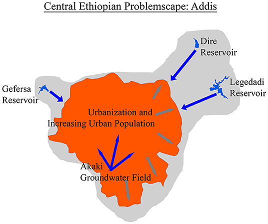
Figure 3. Addis Ababa problemscape.
As well as contributing to the rise in water demand, and without significant increase in surface water production, the increasing urbanization, industrialization, and population acts in combination with the city's poor sanitation to cause severe pollution problems for the rivers that run through the city, namely tributaries to the Akaki river. The impact has been exacerbated by weak institutions and uncoordinated management structures that are unable to deal adequately with the challenges. Improper waste management practices in the city along with poor drainage infrastructure contribute to the disposal of waste in the Akaki river and the surrounding agricultural fields, thereby affecting the uses of the river and jeopardizing agricultural activities. Many factories have been built around the Akaki river, and contaminant-laden wastewater released from these factories also adversely affects the river water.
In rural areas where people use the river for different purposes, including agriculture and livestock, waste coming from the city is seen as a big challenge. The degradation of water quality of the Akaki river by both industrial and municipal waste from Addis has led it to become the most polluted river system in the country (Desalegn et al., 2006; Yohannes and Elias, 2017; Mersha et al., 2018). This high level of pollution is a result of discharging untreated industrial wastewater effluents into nearby waterways along with the widespread use of pit latrines in high population density areas due to only 6.5% of the population in the city being connected to the municipality-managed centralized sewage system [Addis Ababa City Planning Project Office (AACPPO), 2017]. Furthermore, the pollution from Addis has downstream consequences (see Figure 4). The Akaki passes through the downstream Aba Samuel reservoir before meeting the Awash river and consequently Lake Koka, where there is some treatment capability (in terms of dilution) but not at a high level. Therefore, Addis (through the Akaki) pollutes the Awash and surrounding towns. In addition to this, the polluted water is often used for livestock and crop growth, meaning the resulting consumables are also contaminated. For urban irrigation sites in Akaki, a study by Woldetsadik et al. (2017) found that “compared with the WHO recommendations and international standards, the fecal coliform and helminth eggs levels in irrigation water and lettuce samples exceeded the recommended levels.” These products are then often sold in Addis and surrounding Upper Awash areas (e.g., Bishoftu), a cycle contributing to major health hazards in Addis Ababa and the surrounding regions [Addis Ababa City Planning Project Office (AACPPO), 2017]. As well as Addis, there are four other notable cities in the Upper Awash basin: Bishoftu, Mojo, Ginchi, and Sebeta. With Bishoftu and Mojo being part of the Mojo (Modjo) river system, not Awash. In addition to the non-point pollution from Addis to the Awash river system, the pollution of the Awash and Mojo rivers (both contributing to Lake Koka) are added to by the surrounding urban areas, and agricultural and industrial practices in the region (Tessema et al., 2020).
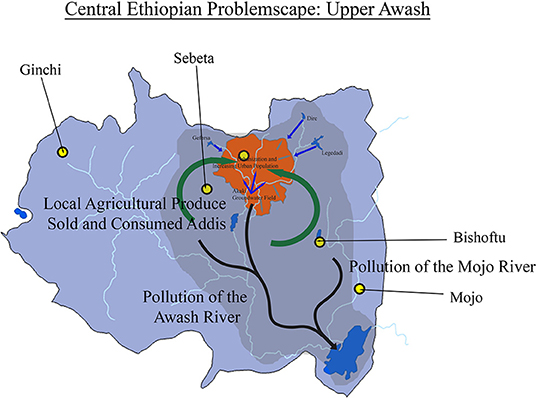
Figure 4. Upper Awash problemscape.
Agriculture has become Ethiopia's primary economic backbone, contributing to around 35% of its GDP (World Bank, 2020). This is molded by national and international market drivers from increasing demand, but most notably the agricultural potential of the CEC has been required to expand to support a growing population. Increases in agricultural activity have resulted in rapid land-use changes birthing a range of issues: land degradation, shrinking landholding, increased irrigation (water use), and pollution of lakes, rivers, and soil. This, moreover, creates competition for land and water amongst various sectors, exacerbated by water scarcity pressures on groundwater and surface water resources. Crucially, the agricultural activities in the CEC connect many regions economically, and semi-hydrologically, through virtual water trade in products. These relationships are shown in Figure 5.
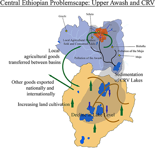
Figure 5. Upper Awash and CRV problemscape.
The CRV basin, sharing the Ziquala mountain belt water-divide with the Upper Awash (Berhanu and Bisrat, 2020), is a closed basin with four major lakes (Ziway, Abyata, Langanao, Shalla). The basin is experiencing intensive agricultural development, mainly for cereals and livestock, alongside increasing population and industry presence (Getnet et al., 2014; Bekele et al., 2018). In the CRV basin, 85% of the population rely on smallholder mixed rain-fed subsistence farming (Bekele et al., 2018) making it extremely economically vulnerable to spatial and temporal shifts in rainfall patterns. As well as this, lakes in the CRV are experiencing sedimentation as a result of land degradation from large-scale land-use change; dependency of wood fuel and increased agricultural activity has resulted in loss of vegetation cover, deforestation (Garedew et al., 2009), and degradation of surrounding rural areas. Sediment is therefore being transported by heavy rain and building up in CRV lakes, also making lowland areas more susceptible to flash flooding. Lake Ziway is an example of this, whereby sedimentation (Desta et al., 2017), evaporation, and abstraction for irrigation and industry (Kebede et al., 1994; Pascual-Ferrer et al., 2014) have reduced the flow of the lake to subsequent downstream lakes. In particular Lake Abayata, as the terminal lake in the closed basin, has suffered as a result and reduced in size by more than 30% between 2000 and 2019 (Donauer et al., 2020). The reduction in lake capacity has an impact on local water resources for many sectors and the huge amount of water loss exacerbates water conflicts amongst diverse users.
As the terminal lake, Abayata suffers various water quality issues, affecting fish production in particular. Deteriorating water quality is also affecting the soil and irrigated vegetables around Lake Ziway. The quality of the lake is mainly being compromised by the intensive use of fertilizers for large- and small-scale irrigation practices in its watershed. The water used for irrigation shows high levels of alkalinity and sodium concentrations that damage agricultural land (Pascual-Ferrer et al., 2014). Among the large-scale irrigation users, the floricultures around Lake Ziway are major users of fertilizers (Hailesilassie and Tegaye, 2019). In addition to the anthropogenic sources of pollution, the basin is also characterized by low water quality because of its geologic formation. For instance, most of the rocky terrain in the CRV is of volcanic origin, leading to fluoride concentrations in groundwater sources of up to 200 mg/l in lower regions [the safe level is below 1.5 mg/l for drinking water; World Health Organisation (WHO), 2017]. Both water quality deterioration and physical water loss from the lakes in the CRV are contributing to water scarcity and creating heightened competition for water between users and sectors in the CRV, such as tourism, agriculture, and fishing (Hengsdijk et al., 2009).
This intensive agriculture is also seen in the Abbay basin, responsible for 40% of Ethiopia's agricultural products (Erkossa et al., 2014). The majority of the population in the Abbay basin crucially depend on rain-fed agriculture as a main livelihood (Mengistu et al., 2021). Additionally, poor land-use management due to increasing agriculture and deforestation has caused severe land degradation in the form of soil erosion, soil infertility, and gully formation (Yalew et al., 2016). As well as this, the basin is extremely vulnerable to climate change impacts such as increased warming and changes to temporal and spatial distribution of rainfall (Mengistu et al., 2021). The Abbay basin suffers similar issues to the CRV, with Lake Tana being subject to sedimentation from upstream land degradation, causing a reduction in capacity and altering the lake ecosystem (Wondie, 2010). There are also rapid changes in the landscape surrounding the basin as eucalyptus plantations abound in rural areas, with farmers switching to a more lucrative and reliable agro-forestry crop. However, unlike the CRV, the Abbay basin shares a hydrological connection with the Upper Awash; a hydraulic connection between the aquifer system of the Upper Awash basin and the two adjacent southern left-bank sub-basins of the Abbay (Mugher and Jema sub-basins; Berehanu et al., 2017). The role of the Abbay in this problemscape is mainly one of presence and influence. Considering the entirety of this basin introduces the transboundary politics of the Abbay, which is not covered in the decision-making conclusions of this paper.
The aforementioned issues are all contained within the space of management and organization, the largest overarching issue network of the CEC. In general, water management, organizational structure, and laws, form an unclear landscape of responsibility and action for water security issues in the CEC. This is largely due to various political ideologies and conflicting political-economic and social frameworks; historical management regimes (e.g., modernization vs. socialist vs. state led free market) have created a management structure with conflicting ideologies that are present to this day. The various ideologies experienced by Ethiopia, and therefore the water sector, over the past several decades have created a complicated management system at national level for the management of water.
The political history of this area will not be covered in depth by this analysis. However, it is important to note some key ideological shifts and events in the last 100 years that have enabled the creation of the governance structure that exists now. Between the years of 1957–1973, national policy in Ethiopia was focused on economic modernization and the establishment of private operators. However, low institutional capacity meant that the water sector was generally underdeveloped with water supply to both rural and urban areas being insufficient. As well as this, land use began to shift toward irrigated agriculture for high value crops for export, industry, and urban consumption, hence beginning to introduce multiple water users and the potential for competing demand. During this regime, the basis of the economy—land—was under a private tenure system run by government and favored exploitative land institutions. The political economic outlook then shifted from a market-based economy to socialist oriented economic development policy for the years 1974–1991, the Derg era of Ethiopia. This shift in national policy meant that progress moved toward regional development and equity including self-sufficient production. The major political economic reform during this time is land nationalization whereby the State controlled the system of land tenure as well as further major expansion of commercial rain-fed and irrigation agriculture. Large scale state farms and state-controlled industries and economic sectors were important features of the regime. Alongside this, urban areas were growing and population increasing. However, because of intensive land use change, surrounding areas saw compounded land degradation and conflict between large irrigation schemes, small holders, and pastoralists. The years following 1991 to present have seen an ideological shift again, this time toward pro-market orientated policy within pragmatic frameworks of political economy, political ecology, power relations, and intersectionality. However, land has still remained under state control. National policy works in a state-led free market to accelerate economic growth and equity. For the water sector, this means that numerous narratives now exist as well as multiple complex institutional arrangements with unclear boundaries and unclear power relations. The pressure on water resources has also increased dramatically, with large increases in population and urbanization as well as an increased water scarcity and competition in some regions. This has created heightened tensions between water users such as the agricultural, industrial, municipal, and rural sectors. Additionally, irrigation on both the large and small scale is still increasing with a varied level of regulation.
Most importantly, after 1991, Ethiopia adopted an ethnic federal management system, meaning that the country is split into 10 regional states with Addis Ababa being one of two autonomous city administrations. Development efforts focused on the Woreda level, although control was continually centralized via the EPRDF—now prosperity party—coalition of parties system. Ethnic regions were given a measure of self-rule authority and the right to develop individual socio-economic development plans (Bekele and Kjosavik, 2016). The new ethnic federal boundaries cross-cut existing physical watershed boundaries promoting regionalism and localism by creating conflicting boundaries between watersheds, administration, and hydrology (shown in Figure 6). For water management this structure means that whilst the region follows a federal structure where federal bodies make laws (e.g., the ministry of water, irrigation, and energy), local bodies can also make laws (e.g., basin development authority). The local bodies' role and power are therefore confused with the mandates of the government. As an example, permits for investors often duplicate in different bodies, but some have more requirements than others meaning the investor is likely to go for the “easy” option to obtaining the necessary permit creating a power rift between various governing bodies. In the cases of large agriculture practices, permitting for water use and regulation is monitored by local mandate, albeit not strictly; however, for small holder farmers regulation is carried out less, and so abstraction from groundwater, lakes, and rivers is unmonitored. Collectively, these many small holdings generate a big impact on the water security of an area and the governance structure means competing mandates impede proper distribution of responsibility and accountability.
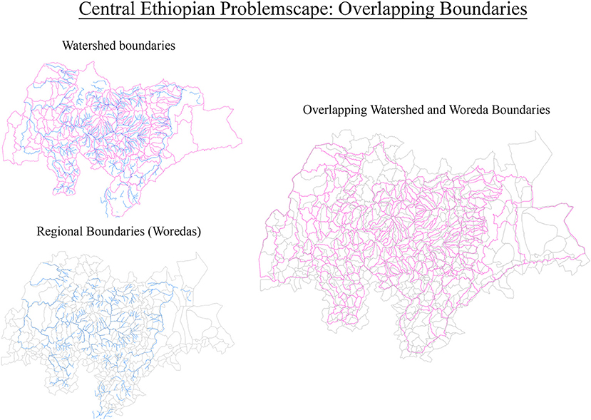
Figure 6. Overlapping boundaries.
The narrative approach to analyzing Addis Ababa's Urbanization, Agricultural, and Land-Use Change, and Management and Organization provides some idea of connectivity and influence within the CEC. However, visualizing the problemscape is also important for demonstrating the spread of drivers and influences as well as interconnectedness between issues; being a graphical depiction of a structured reality. This is one of the main evolutions from the problemsheds concept, taking the conceptual representation of issue networks into an area of action that can be understood by decision makers and stakeholders. Furthering this as a tool for discussion with decision-makers and stakeholders, this visual depiction proves valuable in unlocking new ways of thinking about management and management problems, and also understanding challenges from many actor-based perspectives. However, an issue arises in the transient nature of the problemscape space. Figures 3–5 depict the problemscape in an area of quasi-spatial relevance which aids spatial understanding, but not necessarily an understanding of the overlapping problems and the problemscape. Furthermore, we wish to move away from physical confinements that limit the transient nature of the problemscape. It is important, therefore, to recognize that spatial reference changes within the boundaries of various processes. In this sense, the problemscape is a transient area that has a variety of framings under fluctuating timelines. Whilst it may appear that some areas of the problemscape are fixed, this will only be due to temporal relativity where processes take place on varying time frames, i.e., the disparity between environmental, political, and hydrological cycles.
A way to combat this is to show the problemscape as a conceptual system of connections between problems and areas of action. Building on the previous figures which demonstrate both interconnectedness and nestedness of the water security system of issues in this area. These are combined to form a problemscape of the entire area shown in Figures 7, 8. This visualization of the nature and intensity of the problems represents the problemscaping process as seen from one perspective. The topography of the problemscape will, in all likelihood, change once viewed from say a local farmer or commercial water user. This process of depicting the “scape” and then using the visualization as a form of mental reflection of a particular actor perspective makes comparison between actor perceptions and depictions more interesting and potentially more dynamic as a tool to interrogate perspectives on problem-solving in a context such the CEC.
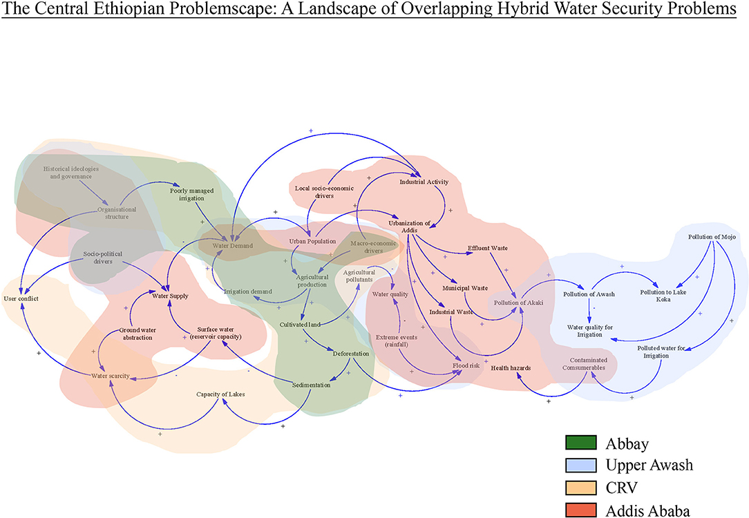
Figure 7. The conceptual CEC problemscape.
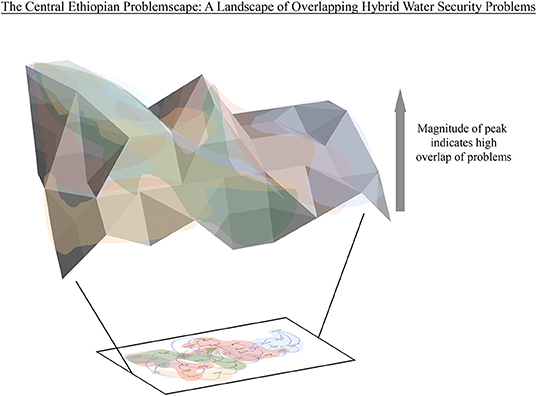
Figure 8. The CEC problemscape landscape.
The initial analysis and construction of the problemscape exposes the interconnectedness and hybridization of water security issues in the CEC area as well as the nestedness of scale and impact. It can be demonstrated that the CEC problemscape has a variety of water security interconnections, including hydrology, geography, sociology, livelihoods, ethnicity, history, administration, institutions, economics, and politics. In addition to this, it can be observed that the nestedness within the water security system of this area is not always proportional to the impact and scale. For example, Addis' water security issues are nested within bigger processes of the Upper Awash and influenced by even larger interactions between global markets and all three basins. However, the presence of Addis and its impact and influence become epicentral to the problemscape even under multiple framings. Spatially and politically, Addis is both highly sensitive to external change and a large owner of water security drivers. Addis is notably a high influencer in terms of physical impacts on the problemscape area (such as groundwater abstraction, domestic, and industrial pollution) as well as an area where uncertainties could create a high level of disruption (such as extreme rainfall)—and where political and administrative change could have major impacts on many relationships between factors determining the shape and dimensions of the problemscape. This is not a surprise, cities are often noted for their environmental, socio-political, and economical influence—and dominance in national political economics. However, it is also the area in which the majority of decision making takes place, where the management institutions reside, as well as the majority of industry and urban population. The second item revealed by the problemscape is the linkage of virtual water between all three areas. The farming of crops and livestock in the area have a direct impact on water security in some cases, but in others, the virtual connections link water security problems through conceptual connections. Such is the case for the links between Addis and its surrounding rural areas. Lastly, what is most interesting about the formation of the problemscape is that it is demonstrated that the points that appear to have the most prevalence in the CEC are those that are not basin confined. For example, macro and local economic drivers, organizational structure, and extreme events. The problemscape exposes these in a way that the basin unit may bury amongst other factors or more “visible” processes. This alludes to the need to find non-conventional solutions to water security problems, in other words, leverage points existing outside the original scope of the traditional water problem framing.
What the problemscape outcomes and process ultimately demonstrate are the vulnerabilities and uncertainties of larger water security problems—crucially, the interconnectedness of water insecurities outside of a basin boundary. Communicating this to planners and practitioners as a form of action research is predicted to be a useful tool to enable integration of water security research and development practice. For example, increasing water supply and sanitation resilience and demand management for multiple fronts. In addition to this, within institutions responsible for water supply in a big city such as Addis Ababa, problemscaping could be used to gain an understanding of the positionality of key actors and how this changes their own problemscape understandings and perceptions. This is currently being explored through co-development of the problemscape process with Addis Ababa Water and Sewage Authority (AAWSA). So far, focus groups from different departments are enabling us to refine the problemscape method and generate problemscape outcomes for water, sanitation, and hygiene in Addis.
The next steps for developing the problemscape concept are to understand agreements and disagreements between the systems representation—the variety of actor-stakeholder perspectives mentioned earlier—and to examine the problemscape from these different perspectives. These could be used in early attempts at mitigating conflict and negotiation solutions to disputes arising from resource competition and scarcities. Comparing problemscapes would also identify optimal leverage areas for integrated water security solutions—essentially hybridizing the discourse on water security. This requires the collection of multiple problemscapes from a range of diverse actors, which will also provide empirical evidence that demonstrates the variation of water security realities. Additionally, providing material that validates whether the practice of problemscaping over different geographies and contextual settings encourages collective interdisciplinary action for immensely complex water challenges. The degree of success for problemscapes improving water management perspectives for water security is still yet to be assessed; however, what is observed as being currently most valuable from this process is the exploration of non-water paths and non-linear insights for water security challenges. In addition to this, the use of both visual and conceptual prompts for navigating hybrid water security complexity in an area containing numerous interconnected issues.
To conclude, the concept of problemscapes not only provides a systems method for navigating water security complexity—and nurturing the notion of hybrid water security—but it also redefines what we mean and include when we discuss water security. In reality, the identification of effective paths of action that may really address water security risks and the viable implementation of solutions, even infrastructural ones, need a deep understanding of this complex hybrid contextual landscape. If anything, this concept demonstrates that water security cannot be seen as a simple concept, but rather a dynamic web of problems that touch a great many societal areas and contribute to the preservation of the many dimensions of water. The concept of problemscapes also reinforces that water security is almost indefinable in that it is contextual to every materialization in time and space. Solutions and solution frameworks must therefore reflect these key characteristics and avoid overly rigid application of a few conceptual dogmas. To further develop problemscapes, this approach needs to be tested in a portfolio of water security scenarios. Including, empirical evidence of improved water management perspectives from different geographies and contextual settings.
The original contributions presented in the study are included in the article/supplementary material, further inquiries can be directed to the corresponding author/s.
XP: concept co-development, paper structure and initial write up, methodology, and figures. AN: concept co-development, application in hybrid water security systems, proof reading of whole document, and disciplinary comments, including various inputs where necessary. AH, MD, and MB: proof reading of whole document, and disciplinary comments, including various inputs where necessary. JA: proof reading and input to introduction (specifically boundaries of management) and discussion. All authors contributed to the article and approved the submitted version.
This work was supported by the Water Security and Sustainable Development Hub funded by the UK Research and Innovation's Global Challenges Research Fund (GCRF) [grant number: ES/S008179/1].
The authors declare that the research was conducted in the absence of any commercial or financial relationships that could be construed as a potential conflict of interest.
All claims expressed in this article are solely those of the authors and do not necessarily represent those of their affiliated organizations, or those of the publisher, the editors and the reviewers. Any product that may be evaluated in this article, or claim that may be made by its manufacturer, is not guaranteed or endorsed by the publisher.
The authors would particularly like to thank colleagues at the International Water Institute (IWMI) and the Water Land Resource Centre (WLRC) in Addis Ababa, Ethiopia.
Abo-El-Wafa, H., Yeshitela, K., and Pauleit, S. (2018). The use of urban spatial scenario design model as a strategic planning tool for Addis Ababa. Landsc. Urban Plann. 180, 308–318. doi: 10.1016/j.landurbplan.2017.08.004
Addis Ababa City Planning Project Office (AACPPO) (2017). Addis Ababa City Structure Plan (2017-2027). Unpublished Planning document. Addis Ababa: AACPPO.
Allan, T. (1998). Watersheds and Problemsheds: Explaining the Absence of Armed Conflict Over Water in The Middle East. Middle East Review of International Affairs. Available online at: https://ciaotest.cc.columbia.edu/olj/meria/meria398_allan.html#txt*
Bakker, K., and Morinville, C. (2013). The management dimensions of water security: a review. Philos. Trans. R. Soc. A 371:20130116. doi: 10.1098/rsta.2013.0116
Bekele, B., Wu, W., Legesse, A., Temesgen, H., and Yirsaw, E. (2018). Socio-environmental impacts of land use/cover change in Ethiopian Central Rift Valley Lakes Region, East Africa. Appl. Ecol. Environ. Res. 16, 6607–6632. doi: 10.15666/aeer/1605_66076632
Bekele, Y., and Kjosavik, D. (2016). decentralised local management and poverty reduction in post-1991 Ethiopia: a political economy study. Polit. Manage. 4, 1–15. doi: 10.17645/pag.v4i4.590
Berehanu, B., Azagegn, T., Ayenew, T., and Masetti, M. (2017). Inter-basin groundwater transfer and multiple approach recharge estimation of the Upper Awash aquifer system. J. Geosci. Environ. Protect. 5, 76–98. doi: 10.4236/gep.2017.53007
Berhanu, B., and Bisrat, E. (2020). Alleviating water scarcity in the central rift valley lakes through an inter-basin water transfer, Ethiopia. Nat. Resour. 11, 554–568. doi: 10.4236/nr.2020.1112033
Birhanu, B., Kebede, S., Charles, K., Taye, M., Atlaw, A., and Birhane, M. (2021). Impact of natural and anthropogenic stresses on surface and groundwater supply sources of the Upper Awash Sub-Basin, Central Ethiopia. Front. Earth Sci. 9:656726. doi: 10.3389/feart.2021.656726
Birhanu, D., Kim, H., Jang, C., and Park, S. (2016). Flood risk and vulnerability of Addis Ababa City due to climate change and urbanization. Proc. Eng. 154, 696–702. doi: 10.1016/j.proeng.2016.07.571
Boelens, R., et al. (2016). Hydrosocial territories: a political ecology perspective. Water Int. 41, 1–14. doi: 10.1080/02508060.2016.1134898
Checkland, P. (1981). Systems Thinking, Systems Practice. Chichester; New York, NY: John Wiley & Sons.
Cohen, A., and Davidson, S. L. (2015). The watershed approach: challenges, antecedents, and the transition from technical tool to governance unit. Water Altern. 4, 1–14. Available online at: https://www.water-alternatives.org/index.php/allabs/130-a4-1-1b/file
Cook, C., and Bakker, K. (2012). Water security: debating an emerging paradigm. Glob. Environ. Change. 22, 94–102. doi: 10.1016/j.gloenvcha.2011.10.011
Desalegn, C., Babel, M., Gupta, A., Seleshi, B., and Merrey, D. (2006). Farmers' perception of water management under drought conditions in the Upper Awash Basin, Ethiopia. Int. J. Water Resour. Dev. 22, 589–602. doi: 10.1080/07900620600779723
Desta, H., Brook, L., and Ephrem, G. (2017). Identifying sustainability challenges on land and water uses: the case of lake Ziway Watershed, Ethiopia. Appl. Geogr. 88, 130–143. doi: 10.1016/j.apgeog.2017.09.005
Donauer, T., Haile, A. T., Goshime, D. W., Siegfried, T., and Ragettli, S. (2020). “Gap and opportunity analysis of hydrological monitoring in the Ziway-Shala Sub-basin, Ethiopia,” in IWMI Working Paper 192 [Colombo: International Water Management Institute (IWMI)], 40. doi: 10.5337/2020.210
Erkossa, T., Haileslassie, A., and MacAlister, C. (2014). Enhancing farming system water productivity through alternative land use and water management in vertisol areas of Ethiopian Blue Nile Basin (Abay). Agric. Water Manage. 132, 120–128. doi: 10.1016/j.agwat.2013.10.007
Garedew, E., Sandewall, M., Söderberg, U., and Campbell, B. M. (2009). Land-use and land-cover dynamics in the central rift valley of Ethiopia. Environ. Manage. 44, 683–694. doi: 10.1007/s00267-009-9355-z
Gerlak, A. K., and Mukhtarov, F. (2015). ‘Ways of knowing' water: integrated water resources management and water security as complementary discourses. Int. Environ. Agreem. 15, 257–272. doi: 10.1007/s10784-015-9278-5
Getnet, M., Hengsdijk, H., and van Ittersum, M. (2014). Disentangling the impacts of climate change, land use change and irrigation on the Central Rift Valley water system of Ethiopia. Agric. Water Manage. 137, 104–115. doi: 10.1016/j.agwat.2014.02.014
Global Water Partnership (2000). Towards Water Security: A Framework for Action. Stockholm: Global Water Partnership.
Global Water Partnership (GWP) (2022). Integrated Water Resources Management Toolbox. Available online at: http://www.gwptoolbox.org (accessed April 22, 2022).
Hailesilassie, W. T., and Tegaye, T. A. (2019). Comparative assessment of the water quality deterioration of ethiopian rift lakes: the case of lakes Ziway and Hawassa. Environ. Earth Sci. Res. J. 6, 162–166. doi: 10.18280/eesrj.060403
Hanasz, P. (2017). Muddy waters: international actors and transboundary water cooperation in the Ganges-Brahmaputra problemshed. Water Altern. 10, 459–474. Available online at: https://www.water-alternatives.org/index.php/alldoc/articles/vol10/v10issue2/365-a10-2-15/file
Hengsdijk, H., Groot, A., Van Driel, J., Jembere, K., Van Uum, J., Boone., et al. (2009). “Towards a sustainable future of the western shoreline of Lake Ziway,” in Participatory Land Use Plan Development Workshop (Wageningen: Plant Research International).
Jaspers, F. G. (2003). Institutional arrangements for integrated river basin managemen. Water Policy. 5, 77–90. doi: 10.2166/wp.2003.0004
Kebede, E., Mariam, Z. G., and, Ahlgren, I. (1994). The Ethiopian Rift Valley Lakes: chemical Characteristics of a salinity-alkalinity series. Hydrobiologia 288, 1–12.
Kifle Arsiso, B., Mengistu Tsidu, G., Stoffberg, G., and Tadesse, T. (2017). Climate change and population growth impacts on surface water supply and demand of Addis Ababa, Ethiopia. Clim. Risk Manage. 18, 21–33. doi: 10.1016/j.crm.2017.08.004
Lankford, B., Bakker, K., Zeitoun, M., and Conway, D. (eds.). (2013). Water Security: Principles, Perspectives and Practices, 1st Edn. London: Routledge.
Lautze, J., and Manthrithilake, H. (2012). Water security: old concepts, new package, what value? Nat. Resour. Forum 36, 76–87. doi: 10.1111/j.1477-8947.2012.01448.x
Mengistu, D., Bewket, W., Dosio, A., and Panitz, H. (2021). Climate change impacts on water resources in the Upper Blue Nile (Abay) River Basin, Ethiopia. J. Hydrol. 592:125614. doi: 10.1016/j.jhydrol.2020.125614
Mersha, A., Masih, I., de Fraiture, C., Wenninger, J., and Alamirew, T. (2018). Evaluating the impacts of IWRM policy actions on demand satisfaction and downstream water availability in the Upper Awash Basin, Ethiopia. Water 10:892. doi: 10.3390/w10070892
Mollinga, P. (2020). Knowledge, context and problemsheds: a critical realist method for interdisciplinary water studies. Water Int. 45, 388–415. doi: 10.1080/02508060.2020.1787617
Mollinga, P., Meinzen-Dick, R., and Merrey, D. (2007). Politics, plurality and problemsheds: a strategic approach for reform of agricultural water resources management. Dev. Policy Rev. 25, 699–719. doi: 10.1111/j.1467-7679.2007.00393.x
Moss, T., and Newig, J. (2010). Multilevel water management and problems of scale: setting the stage for a broader debate. Environ. Manage. 46, 1–6. doi: 10.1007/s00267-010-9531-1
Mukhtarov, F. (2008). Intellectual history and current status of integrated water resources management: a global perspective. Adapt. Integr. Water Manage. 167–185. doi: 10.1007/978-3-540-75941-6_9
OECD (2015). OECD Principles on Water Management. OECD, Water Management in OECD Countries: A Multi-level Approach. Paris: OECD Publishing. Available online at: www.oecd.org/management/oecd-principles-onwater-management.htm. doi: 10.1787/9789264119284-en
Orman, D. (2011). Federal democratic republic of Ethiopia urban water supply and sanitation project consultancy service for master plan review, catchment rehabilitation and awareness creation for Geffersa, Legedadi and, Dire catchments.
Ostrom, E. (2009). A general framework for analyzing sustainability of social-ecological systems. Science 325, 419–422. doi: 10.1126/science.1172133
Ostrom, E., Cole, D., and McGinnis, M. (2017). Elinor Ostrom and the Bloomington School of Political Economy, 1st Edn. London: Lexington Books.
Pascual-Ferrer, J., Pérez-Foguet, A., Codony, J., Raventós, E., and Candela, L. (2014). Assessment of water resources management in the Ethiopian Central Rift Valley. Environmental conservation and poverty reduction. Int. J. Water Resour. Dev. 30, 572–587. doi: 10.1080/07900627.2013.843410
Ponnambalam, K., and Mousavi, S. (2020). CHNS modeling for study and management of human–water interactions at multiple scales. Water 12:1699. doi: 10.3390/w12061699
Sivapalan, M., Savenije, H. H. G., and Blöschl, G. (2012). Socio-hydrology: a new science of people and water. Hydrol. Process. 26, 1270–1276. doi: 10.1002/hyp.8426
Sun, S., Wang, Y., Liu, J., Cai, H., Wu, P., Geng, Q., et al. (2016). Sustainability assessment of regional water resources under the DPSIR framework. J. Hydrol. 532, 140–148. doi: 10.16/j.jhydrol.2015.11.028
Swyngedouw, E. (2009). The political economy and political ecology of the hydro-social cycle. J. Contemp. Water Res. Educ. 142, 56–60. doi: 10.1111/j.1936-704x.2009.00054.x
Terfa, B., Chen, N., Liu, D., Zhang, X., and Niyogi, D. (2019). Urban expansion in ethiopia from 1987 to 2017: characteristics, spatial patterns, and driving forces. Sustainability 11:2973. doi: 10.3390/su11102973
Tessema, K., Lemma, B., Fetahi, T., and Kebede, E. (2020). Accumulation of heavy metals in the physical and biological systems of Lake Koka, Ethiopia: implications for potential health risks. Lakes Reserv. 25, 314–325. doi: 10.1111/lre.12330
The World Bank (2009). Strategic Environmental Assessment: Improving Water Resources Management and Decision Making. Water Sector Board Discussion Paper Series. Washington, DC: The World Bank.
Thissen, W. (2012). Diagnosing policy problem situations. Public Policy Anal. 65–101. doi: 10.1007/978-1-4614-4602-6_4
UN Environment (2018). Progress on Integrated Water Resources Management. Global Baseline for SDG 6 Indicator 6.5.1: Degree of IWRM Implementation. UN Environment.
UN Water the Global Water Partnership (GWP) (2007). UN-Water and the Global Water Partnership (GWP) Roadmapping for Advancing Integrated Water Resources Management (IWRM) Processes. Copenhagen: UN-Water and the Global Water Partnership (GWP). Available online at: https://www.unwater.org/app/uploads/2017/05/UNW_ROADMAPPING_IWRM.pdf
United Nations Department of Economic and Social Affairs (DESA) Population Division (2019). World Urbanization Prospects: The 2018 Revision (ST/ESA/SER.A/420). New York, NY: United Nations.
United Nations University Institute for Water Environment and Health (2013). Water Security and the Global Water Agenda. A UN-Water Analytical Brief. Hamilton: United Nations University Institute for Water, Environment and Health.
Varady, R. G., Albrecht, T. R., Staddon, C., Gerlak, A. K., and Zuniga-Teran, A. A. (2021). “The water security discourse and its main actors,” in Handbook of Water Resources: Discourses, Concepts and Examples, eds J. J. Bogardi, J. Gupta, K. D. Wasantha Nandalal, L. Salamé, R. R. P. van Nooijen, N. Kumar, T. Tingsanchali, A. Bhaduri, and A. G. Kolechkina (Cham: Springer), 215–252.
Warner, J. F., Wester, P., and Hoogesteger, J. (2014). Struggling with scales: revisiting the boundaries of river basin management. Wiley Interdisc. Rev. 1, 469–481. doi: 10.1002/wat2.1035
Woldetsadik, D., Drechsel, P., Keraita, B., Itanna, F., Erko, B., and Gebrekidan, H. (2017). Microbiological quality of lettuce (Lactuca sativa) irrigated with wastewater in Addis Ababa, Ethiopia and effect of green salads washing methods. Int. J. Food Contam. 4:3. doi: 10.1186/s40550-017-0048-8
Wondie, A. (2010). Improving management of shoreline and riparian wetland ecosystems: the case of lake tana catchment. Ecohydrol. Hydrobiol. 10, 123–131. doi: 10.2478/v10104-011-0017-4
World Bank (2020). World Bank National Accounts Data, and OECD National Accounts Data Files. Agriculture, Forestry, and Fishing Value Added (% of GDP). Ethiopia: World Bank. Available online at: https://data.worldbank.org/indicator/NV.AGR.TOTL.ZS?locations=ETandmost_recent_value_desc=true (accessed September 15, 2020).
World Economic Forum (2011). Water Security: The Water-Food-Energy-Climate Nexus: The World Economic Forum Water Initiative. Washington, DC: Island Press.
World Health Organisation (WHO) (2017). Guidelines for Drinking-Water Quality. World Health Organisation.
World Water Council (2015). Integrated Water Resource Management: A New Way Forward. World Water Council. Available online at: https://www.iucn.org/downloads/iwrm_a_new_way_forward_1.pdf
Yalew, S. G., van Griensven, A., Mul, M. L., and van der Zaag, P. (2016). Land suitability analysis for agriculture in the Abbay basin using remote sensing, GIS and AHP techniques. Model. Earth Syst. Environ. 2:101. doi: 10.1007/s40808-016-0167-x
Keywords: water security, Ethiopia, problemshed, problemscapes, water resources, water management, Addis Ababa
Citation: Polaine XK, Nicol A, Amezaga J, Berihun M, Dessalegn M and Haile AT (2022) Problemscapes and Hybrid Water Security Systems in Central Ethiopia. Front. Water 4:800926. doi: 10.3389/frwa.2022.800926
Received: 24 October 2021; Accepted: 20 June 2022;
Published: 14 July 2022.
Edited by:
Miguel R. Peña, University of Valle, ColombiaReviewed by:
M. Dinesh Kumar, Institute for Resource Analysis and Policy, IndiaCopyright © 2022 Polaine, Nicol, Amezaga, Berihun, Dessalegn and Haile. This is an open-access article distributed under the terms of the Creative Commons Attribution License (CC BY). The use, distribution or reproduction in other forums is permitted, provided the original author(s) and the copyright owner(s) are credited and that the original publication in this journal is cited, in accordance with accepted academic practice. No use, distribution or reproduction is permitted which does not comply with these terms.
*Correspondence: Xanthe K. Polaine, eC5wb2xhaW5lMUBuZXdjYXN0bGUuYWMudWs=
Disclaimer: All claims expressed in this article are solely those of the authors and do not necessarily represent those of their affiliated organizations, or those of the publisher, the editors and the reviewers. Any product that may be evaluated in this article or claim that may be made by its manufacturer is not guaranteed or endorsed by the publisher.
Research integrity at Frontiers
Learn more about the work of our research integrity team to safeguard the quality of each article we publish.