- 1Ethiopian Institute of Architecture, Building Construction and City Development (EiABC), Addis Ababa University, Addis Ababa, Ethiopia
- 2Department of Design and Planning, Institute of Technology, Ambo University, Ambo, Ethiopia
- 3Department of Urban and Regional Planning, Institute of Technology, Wollega University, Nekemte, Ethiopia
The informal land market presents a significant challenge to urban land development in many developing countries, including Ethiopia. For example, in cities adjacent to Addis Ababa, rapid horizontal expansion accompanied by various land development issues is a common phenomenon. The study was conducted to examine the effects of the informal land market in Sululta town. Parameters such as the rate of urban expansion, settlement density, level of consumption of the natural environment, and land suitability were used to investigate these problems further. Geographic Information System (GIS), trend analysis models, and overlay analysis, supported by relevant literature reviews, were employed to address the research questions. The study’s findings indicate that Sululta is characterized by low-density urban expansion, significant ecological degradation, and rapid horizontal sprawl. It is recommended that the local government implement an effective land policy to meet the increasing land demand, establish a robust formal land market system, and apply predevelopment urban planning strategies.
1 Introduction
Cities in Sub-Saharan countries are urbanizing rapidly (Tegenu, 2010). As a result, demand for urban land has risen sharply, often exceeding the capacity of cities to meet this need through formal channels (Kasa et al., 2011; Fatta, 2014). Consequently, a significant proportion of urban residents in developing nations gain access to land through informal channels (Rakodi and Leduka, 2003; Durand-Lasserve, 2006; Berner et al., 2007; Wanjiku, 2010; Adesiyan et al., 2011).
In an ideal context, the formal urban land provision mechanism is the major tool for managing urban land, and it should regulate the transaction of land (Cheshire, 2009; Kihato et al., 2010). Accordingly, the land development of urban areas is mainly determined by land transferability and property rights (Lall et al., 2014; King and Napier, 2015; Adam, 2014; Carmona, 2009; Cheshire et al., 2011). Moreover, the best cities have strong formal land markets (Caldeira, 2017).
In cities with informal land markets, it is difficult to bring satisfactory urban development (Fatta, 2014; Sam-Awortwi et al., 2016; Halefom et al., 2018). In such unregulated land transactions, rapid horizontal land encroachment threatens the sustainability of urban areas (Stan, 2013). This expansion predominantly results from the incremental subdivision of urban land tracts within low-density areas. In this situation, it consumes future expansion areas of cities and depletes the ecologically important urban parts (Van Dijk and Fransen, 2008; Napier, 2009; Wanjiku, 2010; Cobbinah and Amoako, 2012).
As one of the fastest-growing economies, Ethiopia is urbanizing rapidly (UN DESA (United Nations Department of Economic and Social Affairs), 2018; Bedane et al., 2019). However, due to the inconsistency of the urban land policies in the past consecutive regimes, the formal mechanism of urban land provision has failed to cope with the huge urban land demand (Belachew and Aytenfisu, 2010; Wubneh, 2018). Consequently, most urban dwellers are unable to take part in the formal land market and turn to the informal one (Dadi et al., 2016; Daniel, 2019; Ministry of Urban Development and Housing, 2016; Nega et al., 2003; Samuelson and Nordhaus, 1992; Yamane, 1967).
Currently, the informal way of urban land claiming is more dominant, and it has brought various urban development defects in most urban areas in the country (Tadesse and Imana, 2017; Bedane et al., 2019; Gemeda et al., 2019). Accordingly, urban centers are characterized by low density and poor infrastructure coverage, and they are primarily informal settlements without municipal registration of legality (Gedefaw, 2015).
The central part surrounding Addis Ababa is the rapidly urbanizing region in the country (Mohamed and Worku, 2019). That enormous amount of agricultural and forest land is being converted into built-up areas rapidly and informally (Woldegerima et al., 2017). Consequently, the government has been anxious to create two different administrative boundaries in just 15 years (Kassa, 2013; Oxford Analytica, 2023; Fink, 1998; Filatova et al., 2009; Gbaguidi and Spellenberg, 2004; Goodfellow, 2017).
It is evident that when land is informally traded, it fails to bring about efficient use. The cities and towns surrounding the capital are under continuous threat of informal land transactions and poor urban development (Getabicha, 2015). Accordingly, such growth results in low-density horizontal expansion of informal settlements, and it is difficult to implement urban plans (Haji and Sulaiman, 2006; Harford, 2006; Kothari, 2004; Lindner, 2014; Tadesse and Imana, 2017).
Sululta is one of the major urban centers in the previously known Oromia Special Zone Surrounding Addis Ababa and the newly formed Sheger City. Currently, the town is struggling with informal land transactions between farmers and land buyers (Girma and Ababa, 2016; Kebede and Singh, 2022). Following that, the town is rapidly expanding and has frequently annexed land into its boundary (Bikis, 2023). Accordingly, the objective of the study is to investigate the effects of the informal land market in the Sululta sub-city.
2 Conceptual framework of the study
The relationship between the inadequacies in formal land markets and urban land development is a critical yet often overlooked research area. Studies have suggested using GIS and satellite imagery, following their growing importance in the field. Therefore, it is important to use multi-temporal urban trend analysis methods such as the urban intensification index and dynamic degree urban expansion (Cheng, 2011; Kasa et al., 2011; Fan et al., 2017).
The informal urban land market is currently creating an uncontrolled urban expansion in Sululta town. It is crucial to explain its effects. There is little awareness of the informal land market and its effects on the urban planning and land development management sectors (Mattingly, 1991; Adams and Tiesdell, 2010; Constitution, 1995; Cunningham, 2011; Dowall, 1993; Dempsey et al., 2010; Dube, 2013). Additionally, there is a limited number of studies that are based on this contemporary urban problem where the issue is not raised frequently, so the study sticks with this very important urban challenge.
The research was conducted to fill the knowledge gap in the area. Accordingly, the study is themed on the rate of urbanization, suitability of settlement pattern, level of consumption in the natural environment, and favorability for plan implementation.
3 Materials and methods
3.1 Background of the study area
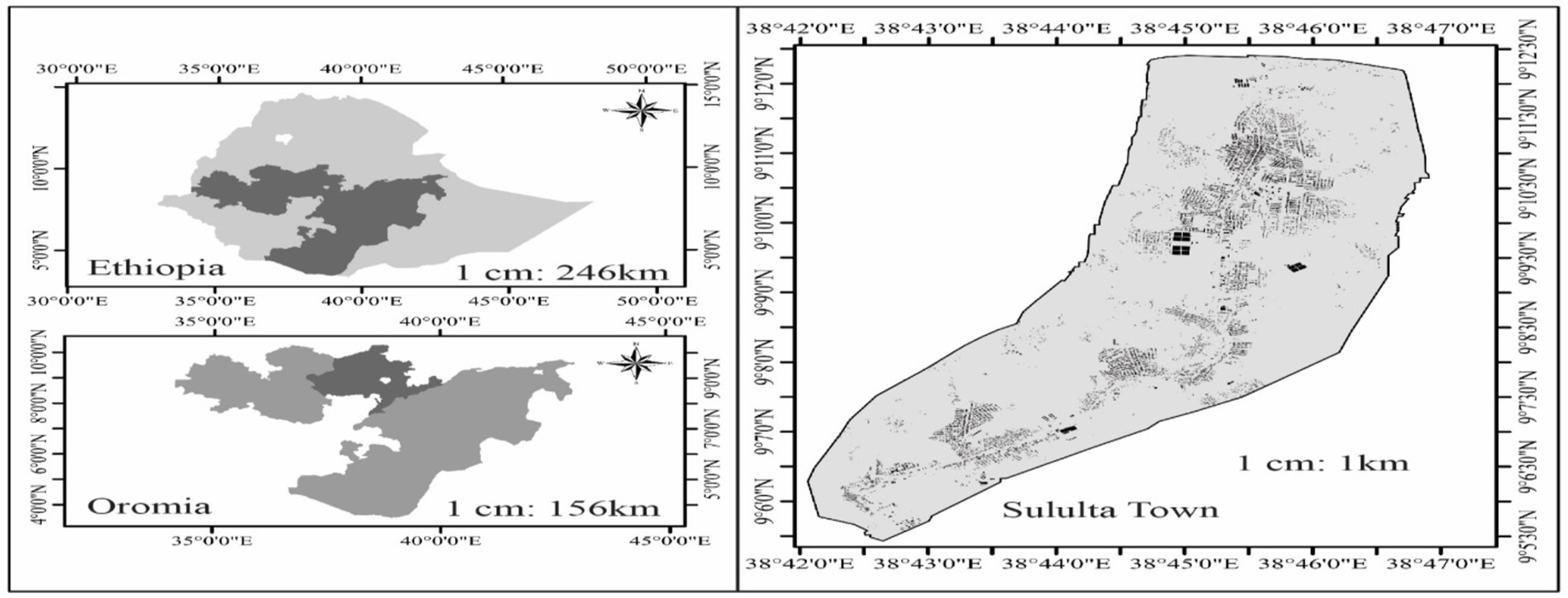
The study was conducted in Sululta, a town situated approximately 25 km north of Addis Ababa, Ethiopia’s capital. Its astronomical location is 90° 5′00″–90° 12′30″N latitude and 380° 41′00″–380° 50′00″E longitudes. Currently, the municipality has a population size of 57,537 and covers 10,216 hectares of land mass (Oromia Urban Planning Institute, 2016). The town is one of the fastest-growing urban centers due to its closeness to Addis Ababa (Girma and Ababa, 2016).
3.2 Data and methods of data collection
Primary and secondary data were collected and used to ensure the study was complete. The primary data were collected through retrieving satellite imagery and official documents. Satellite imageries of the last 20 years in 5-year intervals from 2003 to 2023 G.C. were acquired from the landsat.usgs.gov website. Additionally, official documents such as structure plans and local development plans and manuals were also collected from the town’s Land Management and Development Agency. Secondary data, such as reports and article journals, were collected from trusted websites (Figures 1–7 and Tables 1–5).
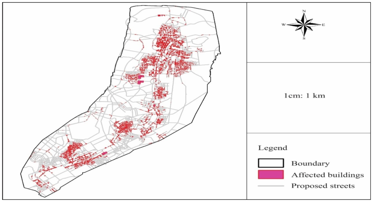
Figure 7. Overly analysis of the affected buildings by the proposed street network in 2016 SP. Source: Field survey, 2024.
3.3 Methods of data analysis
3.3.1 Trend analysis models
An unsupervised, computer-based analysis of satellite imagery was conducted to measure the rate of urbanization and the extent of natural environment consumption. Urban Intensification Index Analysis (UII) and Dynamic Degree Urban Expansion Analysis (K) were used to undertake the trend analysis. The method has a two-step analysis, which proceeds by encoding the trend data of the last 20 years’ horizontal growth, followed by the data analysis. Accordingly, the change in the growth of the settlements was assumed based on block-level analysis to reduce the complexity of the data.
The UII analysis was computed using the following equation to calculate the change in the area of a settlement in accordance with the total area of the town over 5 years.
The urban intensification index (Fan et al., 2017) is expressed as follows:
UII stands for urban intensification index, Uib stands for an urban area at the endpoint of time, Uia indicates the initial time area, TLA denotes the total urban area, and T stands for the time period.
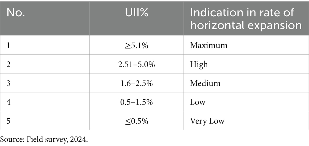
This study used the average value of UII specified by Habitat (2009) on Africa’s urbanization dynamics in African cities and Fan et al. (2017) on Asian cities. The values have been classified into five categories, as indicated in the following table.
The other trend analysis method used in the study is Dynamic Degree Urban Expansion Analysis (K). The value indicates the average rate of change in urban expansion in terms of absolute volume every 5 years according to the following Equation 2.
Dynamic degree urban expansion (Fan et al., 2017) is expressed as follows:
where K stands for the dynamic degree of urban expansion, Uib indicates the urban area at the end time, Uia is the initial urban area, and T stands for the interval time period.
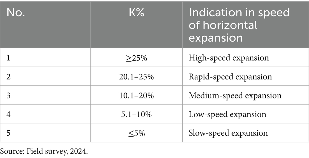
The analysis was conducted by taking the average K value of the classification specified by Habitat (2013) on African cities and Fan et al. (2017) on Asian cities. The average values are classified into five scales, as indicated in the following table.
3.3.2 Settlement density analysis
In this study, the settlement density of the town was calculated using the coverage ratio of the building footprint to the total area of the town. The density of the town’s current land development was computed based on the average density score of the standards being used in Ethiopia. The documents include the Local Development Plan (LDP) Manual of 2006, Standards for Structure Plan Preparation of 2008 and 2012, and Structure Plan Preparation and Implementation Manual of 2016. The density analysis was conducted based on the following score set in the table below regarding the coverage of plot area per hectare of urban land by assuming 5–20% of urban areas are covered by plots of buildings in urban areas.
3.3.3 GIS map overlay analysis
This method (the GIS map overlay analysis) was used to identify the gap between the existing land development pattern and the town’s currently working official. The analysis contains the USGS 2023 satellite imagery and Sululta town’s 2016 Structure Plan to determine the difficulty level for plan implementation.
3.3.4 Descriptive statistics analysis
Variables like the rate of horizontal expansion, the rate of consumption of the natural environment, and the density of settlement patterns are explained in percentage coverage and mean values in addition to the GIS trend and overly analysis.
4 Results and discussion
4.1 Rapid rate of horizontal expansion
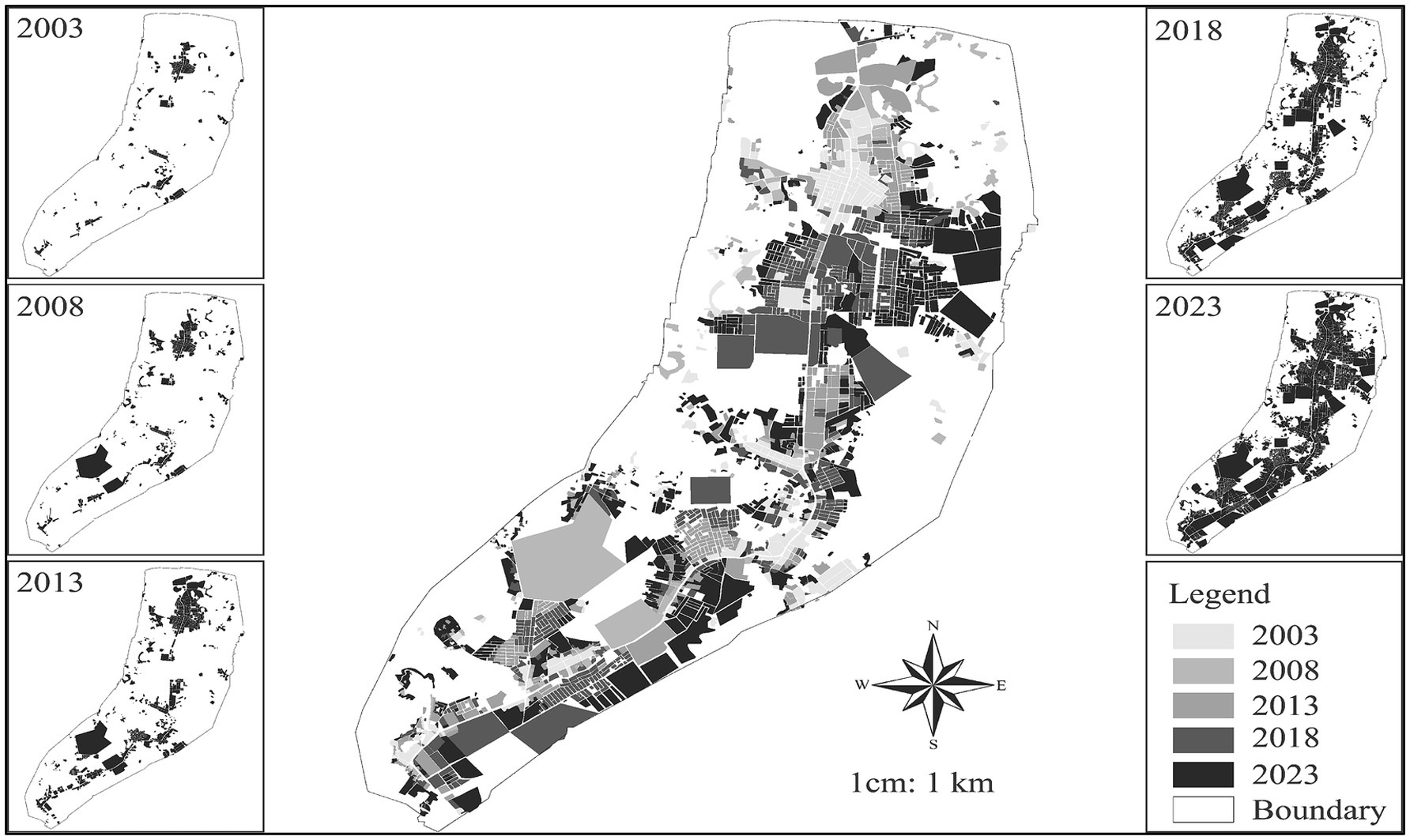
Urban land development pattern indicates the legitimacy of land transactions in a particular urban area. As a result of the informal land market, a rapid successive casual subdivision of land is trendy in Sululta. The multi-temporal trend analysis shows the high intensity of urban expansion and the town’s rapid dynamic degree of urban expansion. These scores indicate rapid urban horizontal growth due to the informal land market, as shown in the following trend map.
The intensity of urban expansion (UII) was calculated using Equation 1. High UII values suggest accelerated urban expansion and significant availability of non-urban space, which facilitates informal land market activities. On the contrary, the lower UII value indicates the low speed of urbanization, the minimum availability of non-urban land for urbanization, and the unlikely situation for the informal land market to operate.
Accordingly, the computed UII values show a great change in urban spatial growth in the last 20 years. The time lap of 2003–2007 has a score of 2.57%, which indicates the rapid urban growth at a high level. Meanwhile, the time period between 2008 and 2012 shows a slight decline in the intensity of the growth with a score value of 1.62%, which falls in the category of medium-intensity growth. The 2013–2017 period shows rapid horizontal growth with a score value of 6.46%, which lies in the category of maximum intensity growth and should be considered seriously. The time period of 2018–2023 has a significant growth value of 3.64%, which is labeled as a high intensity of horizontal growth.
According to the analysis, the only period from 2008 to 2012 had medium-intensity growth with a score value of 1.62%, which was labeled as conducive growth. Meanwhile, the time period from 2003 to 2007 and 2018–2023 had UII values lying in the category of high intensity of urban growth, which shows the difficulty faced in managing the urban land and its development. The 2013–2017 time period has a score value of 6.46%, which lies at a maximum score of tense growth, indicating the immense intensity of urban spatial growth by towering above all the time laps. Despite the higher scores, the average UII value for the last 20 years is 3.57%, which is a high intensity of urban spatial growth for the last two decades.
According to the computation of Dynamic Degree Urban Expansion (K) conducted over the last 20 years of the four-time period classification, The time period 2003–2007 has a score value of 6.82%, which is the low speed of urban expansion according to the stated classes of score values, and even the growth declines to 2.54% in the time period of 2008–2012. However, the growth struck back by scoring a bigK value of 30.06% of additional land area in the time period of 2013–2017, which is indicated to be a very rapid expansion. Additionally, 2018–2023 has taken massive expansion, scoring 22.20% of urban growth and laying in the category of high-speed expansion of urban growth.
The average growth rate of the town for the last 20 years shows enormous urban expansion, with an average value of 15.40% of dynamic degree urban expansion (K). The growth lies in the category of medium-speed expansion due to slower urban growth in the first decade of the study period and very rapid growth in the second half of the study time. The summary of UII and K values is indicated in the following table.
According to both of the computed scores of urban expansion, the town is under very intensive and rapid urban expansion, with average scores of 3.57% UII value and 15.40% K value for the last 20 years. Such rapid expansion consumes a huge part of the non-urban parts, which is fierce and needs to be carefully considered. Such rapid horizontal growth has various urban land development challenges, such as leapfrog development, difficulty in the provision of urban infrastructure, and effects related to the loss and reduction of future expansion areas.
4.2 Low-density settlement patterns
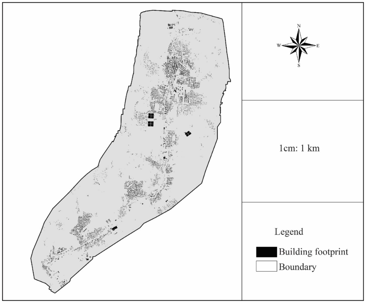
To explain the effects of the informal land market on the town’s land development, the density of the settlement pattern has been undertaken by tracing the entire town’s building footprints from the 2023 USGS satellite imagery. Due to the growing demand for urban land in the town, residents have been forced to forge the informal way, resulting in the expansion of informal settlements mainly characterized by sprawl and low-density horizontal expansion. This situation affects the conduciveness of the settlement patterns in enhancing the livability and sustainability of the urban environment.
The growth trend occurs by continuously dividing large agricultural lands into smaller land-use parcels. The growth creates inappropriate physical arrangements by reducing street hierarchy and missing street connectivity, which leads to a discontinuity in the peripheral parts of the town, as indicated in the following map.
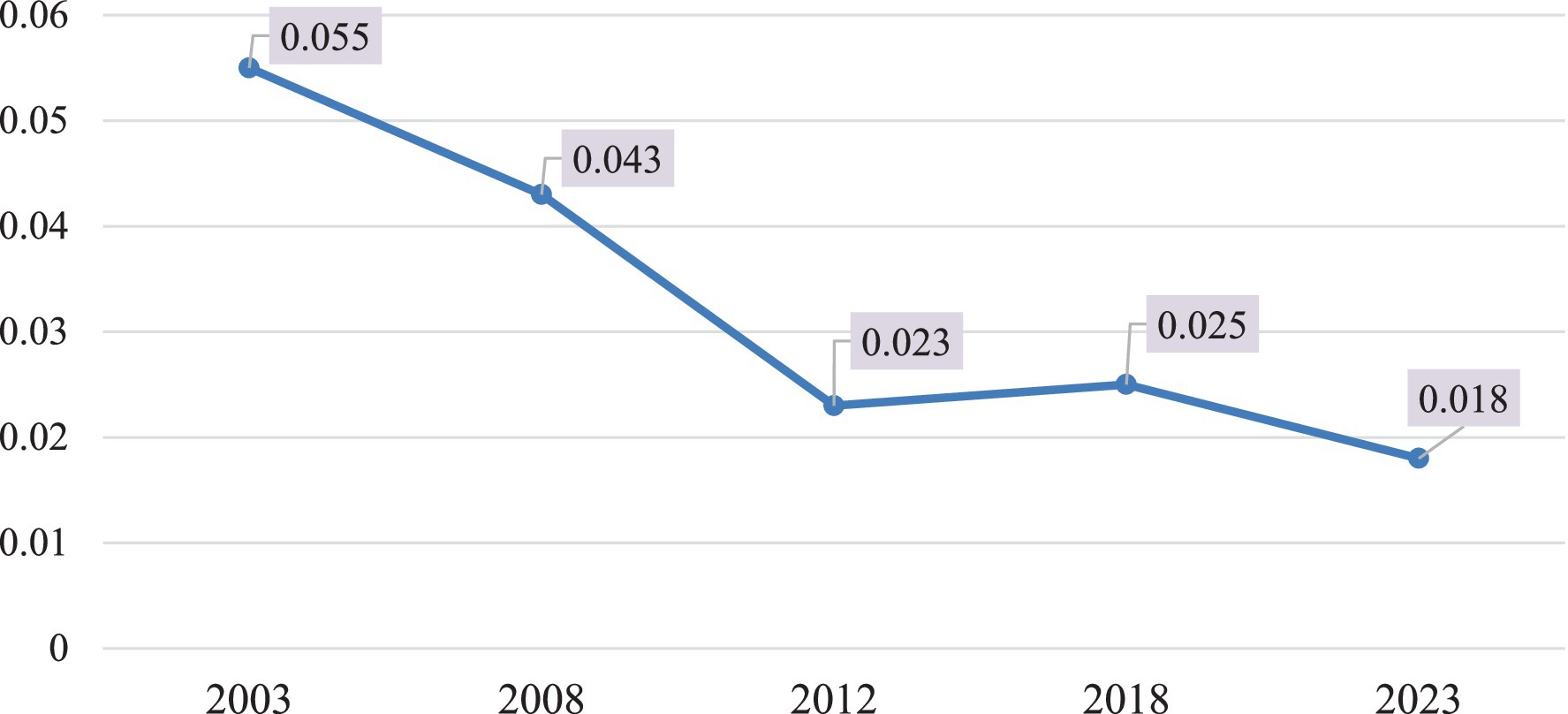
The following graph shows the decreasing settlement density level over the last 20 years.
The town’s density is categorized as medium-scale during 2003–2008. However, the density dramatically declined starting in 2012. This low-density urban growth is one of the major effects of the informal urban market. The market dominantly operates as farmers sell off their land at very cheap prices that, in turn, extend the town horizontally.
4.3 Consumption of the natural environment
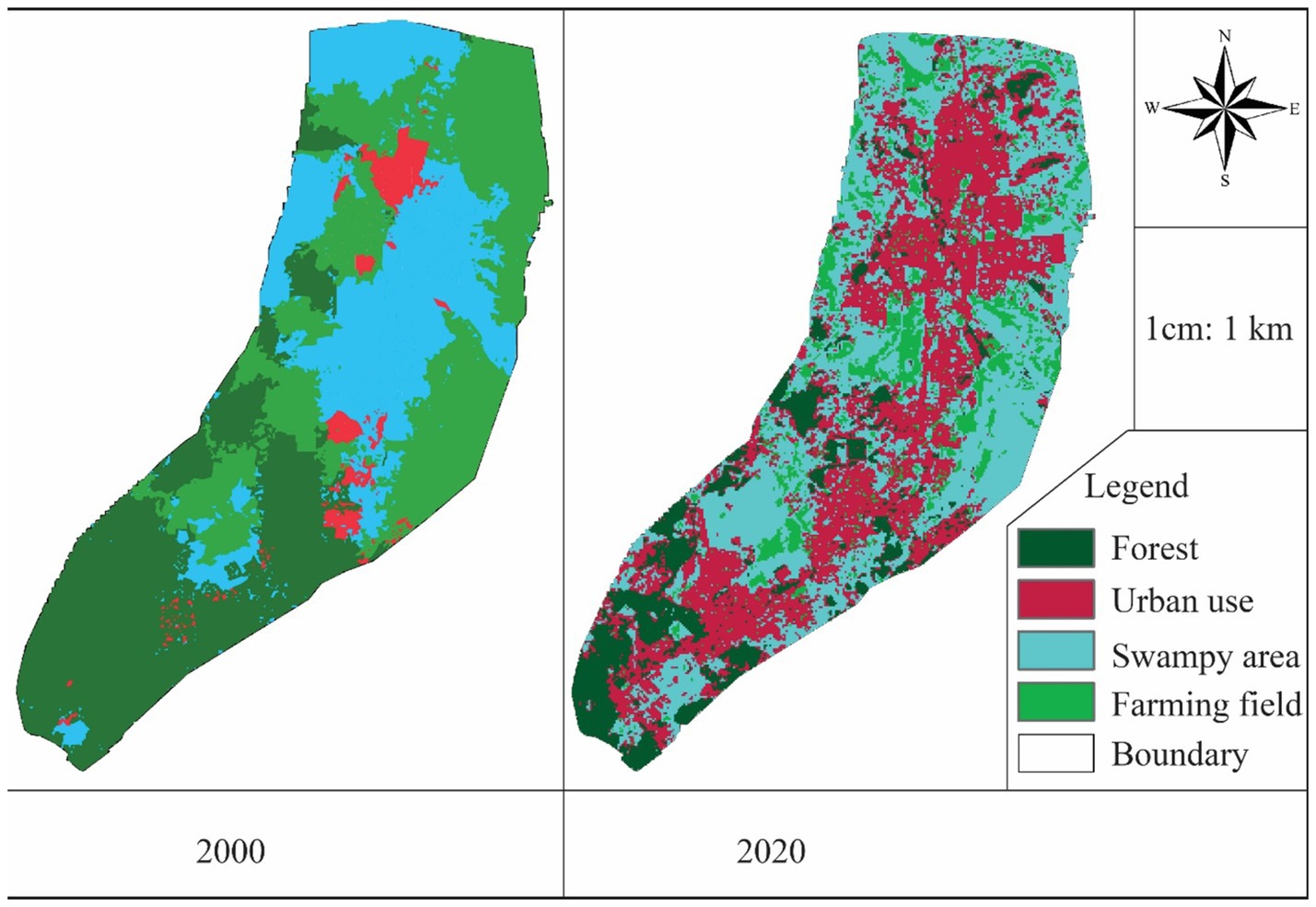
The other variable of the study that explains the effects of the informal land market is the level of consumption of the natural environment. The analysis undertaken includes the urban land cover components such as farming fields, forest lands, swampy areas, and urban uses. The trend analysis uses USGS data sets of the past 20 years in the interval of 5 years from 2003 to 2023 GC.
The dysfunctional formal land market cannot allocate land according to the ever-growing demand for urbanization, which has made the informal land market dominant. In the current situation, the town is continuously expanding and rapidly consuming the natural environment.
The trend analysis shows that urban functions have been taking a huge amount of natural environment, which has environmental sensitivity and important ecological footprints, due to the informal land market. The following trend map shows the severity of the consumption of the natural environment due to the informal land market.
According to the trend analysis, much of the natural environment has been consumed, as indicated in the trend map above. Similarly, the summary of the analysis presented in the table below shows that the swampy areas are reduced by 22% (1,082 ha); the forest coverage has reduced by 9% (448.79 ha), whereas the urban use has increased by 31% (1,483.14 ha) in the last 20 years.
4.4 Difficulty in plan implementation
The urban land development led by the informal land market has also challenged plan implementation. The overlay analysis of the traced map of the USGS 2023 satellite map and the proposed street network of the working structure plan 2016 shows a great mismatch. Accordingly, 7,784 buildings must be demolished to implement the plan as indicated in the following overlay map.
This situation highlights the detrimental effects of the informal land market, as it undermines planned urban development and poses significant challenges to implementation. According to the report from the town’s Land Development and Management Agency of 2023, 1,412 buildings in 2021, 2,655 buildings in 2022, and 166 in 2023 have been demolished in the last 3 consecutive years due to their non-conformity with the plan.
5 Conclusion and recommendations
5.1 Conclusion
As one of the country’s hotspots of urbanization, Sululta town is experiencing an influx of newcomers requiring urban land. Consequently, formal land provision is unable to keep pace, leading to a dominant reliance on informal land transactions. The informal urban land market’s effects on the town’s spatial land development have been found to be significant. Among the diverse effects identified in this study are a rapid rate of horizontal expansion, low-density settlement patterns, unsustainable consumption of natural resources, and challenges in implementing urban planning initiatives.
Based on the study’s key findings, the town has experienced rapid horizontal expansion over the last 20 years due to the informal land market. Both urban expansion analysis models have indicated that the town is undergoing intensive and rapid growth. Additionally, the current urban land development in the town has been characterized as low density, largely due to the informal encroachment on agricultural lands.
The informal land market has also affected the natural environment. The findings show that the town has lost ecologically important areas, with swampy regions declining by 22% and urban forest by 9% over the last 20 years. Additionally, urban farming fields are under threat from encroachment for urban development. The situation is also hindering the implementation of the town’s structure plan, which aims to facilitate proper urban land development.
5.2 Recommendations
As explained in the study, the informal urban land market has immense effects on urban land development in Sululta town. Therefore, the following recommendations are made to bring about sustainable urban development.
To mitigate the effects of the informal market, building the capacity of Sululta’s Land Development and Management Agency is essential. In addition, the agency should work on increasing urban land supply by different sectors that allow the poor and upcoming young to access land before they go to forge land informally. Facilitating safe transactions of urban land that secure property holding rights remains a must for the successful development of the town.
In some cases, reducing the effects of the informal market can be achieved through state-led housing programs because they directly prohibit the rise of urban sprawl. Additionally, a strong land management system that undertakes frequent land inventory by taking immediate action on informal settlements. Managing rapid urbanization and sprawl using infill and urban redevelopment programs can also hinder low-density urban growth. Additionally, land pooling, especially around the fringe parts of the town, to achieve economic land development also helps reduce informality effects from encroachment. Consultation and enabling local farmers around fringe parts of the town is also essential.
The other concerning issue of the informal land market is the town’s continuous diminishing of the natural environment. Accordingly, protecting the ecologically important footprints is very important to bring about sustainable urban development. Since informality is dominantly in action, it is crucial to focus on ensuring the town plan implementation and other development regulations regularly.
6 Limitations of the study
This study has focused solely on the four basic areas of urban land development. However, it does not address other important aspects, such as detailed morphological patterns, accessibility to services and infrastructures, or the socio-economic effects on residents. Therefore, future studies should investigate the comprehensive impacts of urban land development resulting from the informal land market.
Data availability statement
The raw data supporting the conclusions of this article will be made available by the authors without undue reservation.
Ethics statement
The studies involving humans were approved by Dr. Bedane Shata Gemeda, Addis Ababa University. The studies were conducted in accordance with the local legislation and institutional requirements. The participants provided their written informed consent to participate in this study.
Author contributions
BA: Conceptualization, Data curation, Investigation, Project administration, Resources, Writing – original draft, Writing – review & editing. BD: Investigation, Software, Writing – review & editing. AB: Investigation, Supervision, Writing – original draft.
Funding
The author(s) declare that no financial support was received for the research, authorship, and/or publication of this article.
Acknowledgments
First, we would like to thank God. Then, we express our great appreciation to all staff members of Sululta Town Land Management and Development Agency, especially Mr. Abel Girma and Mr. Tadele Yado, for their irreplaceable contribution to this study. Following that, we acknowledge all of the participants during data collection.
Conflict of interest
The authors declare that the research was conducted in the absence of any commercial or financial relationships that could be construed as a potential conflict of interest.
Publisher’s note
All claims expressed in this article are solely those of the authors and do not necessarily represent those of their affiliated organizations, or those of the publisher, the editors and the reviewers. Any product that may be evaluated in this article, or claim that may be made by its manufacturer, is not guaranteed or endorsed by the publisher.
References
Adam, A. G. (2014). Informal settlements in the peri-urban areas of Bahir Dar, Ethiopia: an institutional analysis. Habitat Int. 43, 90–97. doi: 10.1016/j.habitatint.2014.01.014
Adams, D., and Tiesdell, S. (2010). Planners as market actors: rethinking state–market relations in land and property. Plan. Theory Pract. 11, 187–207. doi: 10.1080/14649351003759631
Adesiyan, O. S., Ayedun, A. A., and Iroham, E. O. (2011). Informal land market: alternative approach to sustainable mass residential housing provision in South-Western Nigeria. Asian J. Bus. Manag. Sci. 1, 97–104.
Bedane, G. S., GirmaAbebe, B., and Eckardt, F. (2019). Urban land speculation; failure of land market. Surv. Rev. 53, 1–7. doi: 10.1080/00396265.2019.1661165
Belachew, M., and Aytenfisu, S. (2010). Facing the challenges in building sustainable land administration capacity in Ethiopia. In FIG congress, Sydney, Australia.
Berner, B., Dunn, T. C., Farinas, K. C., Garrison, M. D., Kurnik, R. T., Lesho, M. J., et al. (2007). U.S. patent no. 7,295,867. Washington, DC: U.S. Patent and Trademark Office.
Bikis, A. (2023). Quantifying and analyzing the impact assessment on land use change of urban growth using a timeline. Environ. Sci. Pollut. Res. 30, 62762–62781. doi: 10.1007/s11356-023-26443-1
Caldeira, T. P. (2017). Peripheral urbanization: autoconstruction, transversal logics, and politics in cities of the global south. Environ. Plan. D Soc. Space 35, 3–20. doi: 10.1177/0263775816658479
Carmona, M. (2009). The isle of dogs: four development waves, five planning models, twelve plans, thirty-five years, and a renaissance… of sorts. Prog. Plan. 71, 87–151. doi: 10.1016/j.progress.2008.10.001
Cheng, V. M. Y. (2011). Infusing creativity into eastern classrooms: evaluations from student perspectives. Think. Skills Creativity 6, 67–87.
Cheshire, P. (2009). Urban land markets and policy failures. Land Use Futures discussion papers, Foresight. London, UK: Department for Business Innovation and Skills.
Cheshire, P., Hilber, C. A., and Kaplanis, I. (2011). Evaluating the effects of planning policies on the retail sector: Or do town center first policies deliver the goods? SERC Discussion Papers (SERCDP0066). London, UK: Spatial Economics Research Centre, London School of Economics and Political Science.
Cobbinah, P. B., and Amoako, C. (2012). Urban sprawl and the loss of peri-urban land in Kumasi, Ghana. Int. J. Soc. Hum. Sci. 6:e397.
Constitution, F. D. R. E. (1995). The constitution of the Federal Democratic Republic of Ethiopia. Addis Ababa 1:64.
Cunningham, S. (2011). Understanding market failures in an economic development context. Pretoria, South Africa: Mesopartner Monograph, 4.
Dadi, D., Azadi, H., Senbeta, F., Abebe, K., Taheri, F., and Stellmacher, T. (2016). Urban sprawl and its impacts on land use change in Central Ethiopia. Urban For. Urban Green. 16, 132–141. doi: 10.1016/j.ufug.2016.02.005
Daniel, G. A. (2019). Assessment of urban land lease and housing market of Mek’ele city. Addis Ababa University, College of Development Studies.
Dempsey, N., Brown, C., Raman, S., Porta, S., Jenks, M., Jones, C., et al. (2010). “Elements of urban form” in Dimensions of the sustainable city (Dordrecht: Springer), 21–51.
Dowall, D. E. (1993). The role and function of urban land markets in market economies. Ukraine: Kiev.
Dube, E. E. (2013). Urban planning & land management challenges in emerging towns of Ethiopia: the case of Arba Minch. J. Urban Environ. Eng. 7, 340–348. doi: 10.4090/juee.2013.v7n2.340-348
Durand-Lasserve, A. (2006). Informal settlements and the millennium development goals: global policy debates on property ownership and security of tenure. Glob. Urban Dev. 2, 1–15.
Fan, Y., Zhu, X., He, Z., Zhang, S., Gao, J., Chen, F., et al. (2017). Urban expansion assessment in Huaihe River basin, China, from 1998 to 2013 using remote sensing data. J Sens 2017, 1–10. doi: 10.1155/2017/9281201
Fatta, G. A. (2014). The effect of land speculation on the housing in the city of Jeddah. Indiana: Ball State University Muncie, College of Architecture and Planning.
Filatova, T., Parker, D., and Veen, A. (2009). Agent-based urban land markets: pricing behavior, and urban land use change. J. Artif. Soc. Soc. Simulat. 12:3.
Fink, A. (1998). Conducting literature research reviews: from paper to the internet. Thousand Oaks, CA: Sage Publications, Inc.
Gbaguidi, A. N., and Spellenberg, U. (2004). “Benin: globalisation and land tenure changes in peri-urban areas” in Local land law and globalization. eds. G. Woodman, U. Wanitzek, and H. Sippel (Hamburg: Lit Verlag), 81–151.
Gedefaw, M. (2015). Assessing the current status of solid waste management of Gondar town, Ethiopia. Int. J. Sci. Technol. Res. 4, 28–36.
Gemeda, B. S., Abebe, B. G., and Cirella, G. T. (2019). The role of land speculators around the urban edge of Shashemene City, Ethiopia. Eur. J. Sustain. Dev. Res. 4:em0108. doi: 10.29333/ejosdr/6296
Girma, B., and Ababa, A. (2016). Urban expansion and its socio-economic impacts on the livelihood of the farming community in Sululta.
Goodfellow, T. (2017). Taxing property in a neo-developmental state: the politics of urban land value capture in Rwanda and Ethiopia. Afr. Aff. 116, 549–572. doi: 10.1093/afraf/adx020
Habitat, U. N. (2009). Global report on human settlements 2009: planning sustainable cities. London: Earthscan.
Habitat, U. N. (2013). State of the world's cities 2012/2013: prosperity of cities. UN-HABITAT: Rutledge.
Haji, M. Ali, and Sulaiman, Salim M.. (2006). The causes and consequences of the informal settlements in Zanzibar.
Halefom, A., Teshome, A., Sisay, E., and Ahmad, I. (2018). Dynamics of land use and land cover change using remote sensing and GIS: a case study of Debre Tabor town, South Gondar, Ethiopia. J. Geogr. Inf. Syst. 10, 165–174. doi: 10.4236/jgis.2018.102008
Harford, J. D. (2006). Congestion, pollution, and benefit-to-cost ratios of US public transit systems. Transp. Res. Part D: Transp. Environ. 11, 45–58. doi: 10.1016/j.trd.2005.09.001
Kasa, L., Zeleke, G., Alemu, D., Hagos, F., and Heinimann, A. (2011). Impact of urbanization of Addis Abeba city on peri-urban environment and livelihoods. Addis Ababa, Ethiopia: Sekota Dry land Agricultural Research Centre of Amhara Regional Agricultural Research Institute.
Kassa, F. (2013). Conurbation and urban sprawl in Africa: the City of Addis Ababa case. Ghana J. Geogr. 5, 73–89.
Kebede, B., and Singh, K. N. (2022). Implication of land acquisition on the livelihood assests of farm households in SebetaHawas and SulultaWoredas of Oromia, Ethiopia. GeoJournal 87, 1–9.
Kihato, C., Gavera, L., and Momoniat, Y. (2010). Urban land markets: economic concepts and tools for engaging in Africa. UN Habitat.
King, N., and Napier, M. (2015). Market interventions for sustainable cities: understanding land markets. Urban Land Paper Ser. 1, 1–13.
Kothari, C. R. (2004). Research methodology: Methods and techniques. Scientific Research, New Age International.
Lall, S. V., Freire, M., Yuen, B., Rajack, R., and Helluin, J. J. (2014). Urban land markets. Springer.
Mattingly, M. (1991). Urban land markets in developing countries: do planners know enough about them? Land Use Policy 8, 90–94. doi: 10.1016/0264-8377(91)90001-Y
Ministry of Urban Development and Housing (2016). Ethiopia national urban development spatial plan national urban systems study final report. Addis Ababa.
Mohamed, A., and Worku, H. (2019). Quantification of the land use/land cover dynamics and the degree of urban growth goodness for sustainable urban land use planning in Addis Ababa and the surrounding Oromia special zone. J. Urban Manag. 8, 145–158. doi: 10.1016/j.jum.2018.11.002
Napier, M. (2009). “Making urban land markets work better in south African cities and towns: arguing the basis for access by the poor” in Urban land markets (Dordrecht: Springer), 71–97.
Nega, B., Adenew, B., and GebreSellasie, S. (2003). Current land policy issues in Ethiopia. Land Reform Land Settl. Cooper. 11, 103–124.
Oromia Urban Planning Institute (2016). Sululta town structure plan document. Addis Ababa, Ethiopia.
Oxford Analytica. (2023). ‘Sheger City’ plan will fuel Ethiopia tensions. Emerald Expert Briefings, (oxan-db).
Rakodi, C., and Leduka, R. C. (2003). Informal land delivery processes and access to land for the poor in six African cities: towards a conceptual framework. Scientific Research, University of Birmingham.
Sam-Awortwi, W. E., Kwatia, J. K. B., and Asuah, A. Y. (2016). Impact of the land market on spatial development: a study of EJISU township, Ghana. Int. J. Eng. Appl. Sci. 3:257573.
Stan, A. I. (2013). Morphological patterns of urban sprawl territories. Urban. Arhit. Constr. 4, 11–24.
Tadesse, E., &Imana, G., (2017). Prospects and challenges of urbanization on the livelihood of farming community.
Tegenu, T., (2010). Urbanization in Ethiopia: Study on growth, patterns, functions and alternative policy strategy.
UN DESA (United Nations Department of Economic and Social Affairs) (2018). World Urbanization Prospects: The 2018 Revision. United Nations Department of Economic and Social Affairs.
Van Dijk, M. P., and Fransen, J. (2008). Managing Ethiopian cities in an era of rapid urbanisation : EburonUitgeverij BV.
Wanjiku, C. (2010). Response strategies adopted by multinational Cooperations to cope with barriers of entry into the Kenyan market. Nairobi: Unpublished MBA Project, School of Business, University of Nairobi, Kenya.
Woldegerima, T., Yeshitela, K., and Lindley, S. (2017). Characterizing the urban environment through urban morphology types (UMTs) mapping and land surface cover analysis: the case of Addis Ababa, Ethiopia. Urban Ecosyst. 20, 245–263. doi: 10.1007/s11252-016-0590-9
Wubneh, M. (2018). Policies and praxis of land acquisition, use, and development in Ethiopia. Land Use Policy 73, 170–183. doi: 10.1016/j.landusepol.2018.01.017
Keywords: urban land development, informal land market, urban morphology, urban intensity index, dynamic degree urban expansion, Sululta
Citation: Abebe BG, Dadi BU and Bifa AO (2024) The effects of informal land markets on urban land development in rapidly growing urban areas: the case of Sululta town, Ethiopia. Front. Sustain. Cities. 6:1457336. doi: 10.3389/frsc.2024.1457336
Edited by:
Jianquan Cheng, Manchester Metropolitan University, United KingdomReviewed by:
Wenjian Pan, Huazhong University of Science and Technology, ChinaZeineb Kassouk, Institut National Agronomique de Tunisie, Tunisia
Copyright © 2024 Abebe, Dadi and Bifa. This is an open-access article distributed under the terms of the Creative Commons Attribution License (CC BY). The use, distribution or reproduction in other forums is permitted, provided the original author(s) and the copyright owner(s) are credited and that the original publication in this journal is cited, in accordance with accepted academic practice. No use, distribution or reproduction is permitted which does not comply with these terms.
*Correspondence: Birhanu Girma Abebe, YmlyaGFudS5naXJtYUBhYXUuZWR1LmV0
 Birhanu Girma Abebe
 Birhanu Uma Dadi2
