 Elizelle Juanee Cilliers
 Wim Timmermans
 Hildegard Rohr1
 Hasse Goosen
94% of researchers rate our articles as excellent or good
Learn more about the work of our research integrity team to safeguard the quality of each article we publish.
Find out more
ORIGINAL RESEARCH article
Front. Sustain. Cities, 12 April 2022
Sec. Urban Greening
Volume 4 - 2022 | https://doi.org/10.3389/frsc.2022.624046
This article is part of the Research TopicNature-Based Solutions for Urban AreasView all 10 articles
Nature-based solutions are gaining importance within the notion of urban sustainability problems and associated global goals. This paper argues that nature-based solutions could guide climate adaptation planning, but it would need to be scaled-up across the globe to have an effective impact on climate adaptation. Literature poses various proposals of how to include nature-based solutions to guide adaptation planning, but practical examples and evidence of such are more limited. This paper addresses this lack by providing examples of two case studies, one in the Netherlands (Amersfoort) and one in South Africa (Lephalale). These two case studies were purposefully selected based on the nature-based approaches they employed in response to climate change challenges. The cases were accordingly considered in terms of their socio-ecological and environmental context, the scale of implementation of the nature-based solutions, the flexibility of these responses employed, and the overall benefits provided through the nature-based approaches. A comparative analysis was conducted between the two cases and highlighted that nature-based approaches could not be limited to a singular ad-hoc approach, but should rather be scaled up and more comprehensive, in order to align with the objectives of climate adaptation planning. The cases evidenced how the broader environment could benefit when nature-based solutions are scaled up to guide climate adaptation.
Climate adaptation planning is becoming a reality for all cities across the globe (Araos et al., 2016, p. 375) in light of growing concerns of the significant risks related to climate change (Revi et al., 2014). These risks include amongst other rising sea levels, storm surges, heat increases, extreme precipitation, inland and coastal flooding, landslides, drought, increased aridity, water scarcity, and air pollution, which would ultimately have widespread negative impacts on people, on their health, livelihoods, and assets, but simultaneously also have an impact on global economies and ecosystems (Revi et al., 2014; Gibbs, 2015, p. 207; European Environmental Agency, 2016, p. 105–310; Hu et al., 2016, p. 1083). The severe consequences of climate change have resulted in more demanding debates on climate adaptation in policy and practice (Kennedy et al., 2010, p. 805). Flexibility was amongst others identified as a crucial policy consideration in response to changing environments and circumstances (Radhakrishnan et al., 2018, p. 87). Flexibility in this sense conforms to the objectives of context-based planning, acknowledging that a “one-size-fits-all” approach will likely be unsuccessful (Bulkeley and Tuts, 2013, p. 650). Although flexibility provides scope to address a range of pressures that influence the ability to respond to climate vulnerability and adaptation, it is also the very nature of flexibility that often leads to uncertainty about relevance and applicability of possible solutions within various contexts. As climate adaptation planning is a new pathway for structuring mainstream spatial planning, it might well be explored from the “safe-to-fail” approach proposed by Ahern (2011), in anticipating failures and designing systems strategically to limit the possible failures as we proceed (Steiner, 2006). It is within this flexible approach that many global cities now prioritize climate adaptation planning.
Nature-based solutions resort as an umbrella concept encapsulating various planning approaches under which ecological engineering, green infrastructure planning, ecosystem services approaches, and water sensitive planning approaches are, amongst others, included (Thomas and Littlewood, 2010; Nesshöver et al., 2017). Nature-based solutions are therefore a concept that utilizes the multi-functionality of the natural systems (Fink, 2017, p. 254) and in doing so, establishes a linkage between the environmental, economic, and social dimensions of the city (Nesshöver et al., 2017). Research of Barton et al. (2017) proved that there are actually unique trade-off values between these economic, social, and environmental objectives, as it “transitions” from a resource-intensive development model toward a more resource-efficient, comprehensive and sustainable development display (Cohen-Shacham et al., 2016, p. 2; Faivre et al., 2017).
Within this understanding, environmental conservation has mostly been motivated by a wide range of ethical, utilitarian, aesthetic, and economic concerns (Doak et al., 2015, p. 77–81) and often linked to the diverse range of concepts such as green-blue infrastructure, ecosystem approach, ecological engineering, catchment systems engineering, ecosystem services framework, natural capital, or ecosystem-based adaptation as part of the broader nature-based thinking (De Ridder, 2019).
Such nature-based approaches further align with the objectives of sustainability and resilience (Peter et al., 2017). There is however a lack in literature pertaining to the suitability of nature-based solutions (Peter et al., 2017, p. 284), especially in terms of the urbanization-related risk elements in the long haul (Hartig et al., 2014) and how cities should embrace flexibility in diverse urban settings.
Some nature-based solutions already implemented in water management and urban planning (e.g., green roofs, vegetation in street canyons, bio-infiltration rain gardens) have already proven to be more than the “gray infrastructure” possibilities (Liquete et al., 2016, p. 393). Where the focus once was on civil and engineering processes, with the objective to move (for one example) water out of cities as swiftly as possible, nature-based solutions now call for a revised approach to city planning, to keep water in cities and benefit from a closed-circle planning approach, which are deemed for efficiently, cost-effectively, and sustainable.
There is thus scope to reinstate the importance of the nature-based approaches as part of mainstream spatial planning, in an attempt to guide climate adaptation planning, but political will along with practical approaches are needed to steer the planning profession in this direction. Adaptation planning research has highlighted the need for comparative studies, supported by a systematic analysis of adaptation actions taken across nations and cities (Araos et al., 2016, p. 375) to mobilize political will and inform broader adaptation planning best practices.
Such a holistic approach would accordingly to Raymond et al. (2017) require a comprehensive understanding of (1) the socio-ecological and environmental context of nature-based design, (2) various scales of implementation of nature-based solutions, (3) flexible responses to possible arising risks based on the “learn-by-do” approach, and (4) assessing of nature-based solutions and related benefits to manage trade-offs and optimize co-benefits.
In an attempt to provide such a point of departure for the creation of coherent approach to guide adaptation planning in cities from a nature-based approach, this paper identified and evaluated two case studies which employed nature-based approaches in respond to climate change challenges. From these cases it became evident that nature-based approaches are often limited to a singular ad-hoc approach, and should rather be scaled up and more comprehensive, when aiming to steer mainstream spatial planning to align with the objectives of climate adaptation planning, as described accordingly.
Two case studies were purposefully selected based on the nature-based approaches they employed in response to climate change challenges, one from the global North (Amersfoort in the Netherlands) and one from the global South (Lephalale in South Africa). A case study analysis was conducted between the cases, as this approach is often used in planning literature (Association of African Planning Schools, 2010, p. 5) as it describes deeper and more complex understandings of phenomena (Moore et al., 2012). Swanborn (2010) highlighted how a multiple-case study design considers a series of instances of the same phenomenon occurring within different conditions, and the two cases in this empirical investigation provided the adequate background for such approach. Accordingly, both cases were considered in terms of the aspects identified by Raymond et al. (2017) including socio-ecological and environmental context, the scale of implementation of nature-based solutions, the flexibility of responses employed, and the benefits provided through the nature-based approach, as described in Section Case Study 1: Amersfoort Opportunity Maps (Netherland's Approach). A comparative analysis was conducted and presented in Section Case Study 2: Lephalale Local Municipality Water Sensitive Design (South African Approach), and highlighted that nature-based approaches could not be limited to a singular ad-hoc approach, but should rather be scaled up and more comprehensive, to align with the objectives of climate adaptation planning. The two case studies are accordingly described and evaluated.
The challenges of climate adaptation in the Netherlands are strongly related to water management since 25% of the country is located below sea level (Wezel, 2019). As part of the National Adaptation Strategy all local municipalities in the Netherlands are required to develop their own adaptation plan, inclusive of a stress test that measures the expected effects of climate change, a risk dialogue conducted with relevant stakeholders and an implementation plan. In support of the adaptation strategy, the DNA project was launched which considers the DNA of the spatial environment, including the functioning of the natural system of soil, subsurface, landscape, water, and cultural history. The DNA project considered data pertaining to soil and geomorphological conditions which are publicly available in the form of the national geomorphological map. Deeper surface data of individual municipalities are however often not portrait as integrated layers within the geomorphological map, which does pose some challenges to standardize the approach.
In response, the city system analysis was proposed as a nature-based solution to spatial planning. The city system analysis considered the built environment and subsurface simultaneously, in an attempt to identify water capturing and infiltration opportunities. Infiltration opportunities were especially important in more arid areas to ensure the capturing of groundwater. In areas with adequate groundwater, initiatives such as green roofs were considered to help with the absorption of additional water flow. In essence the diverse landscapes and water availability per area led to the development of water opportunity maps to identify the possible opportunities for each specific area that would contribute to the broader water balance of the city. Amersfoort, a city in the Netherlands was one such city where these analyses was conducted.
Amersfoort, situated at the eastern edge of the Randstad and being is the fifteenth-largest city in the Netherlands, was included as one of six pilot studies in the DNA project and also one of two in which detailed soil and surface analyses were included in the research. Water plays a crucial part of the environmental context of Amersfoort as the river Eem begins in Amersfoort and connects to the nearby Eemmeer (Lake Eem). According to the local municipality the aim was to find suitable solutions for the dry summers, specifically to retain water better and for longer, while also including measures to combat heat stress related to the increase in summer temperatures (Gemeente Amersfoort, 2020). The objective in Amersfoort was to include soil and ground surface as part of broader climate adaptation planning and to assist local decision-makers on future planning proposals and projects, by considering the increase of extreme future rainfall, as provided the Climate Effect Atlas, as well as the nature base system on GIS maps of the adjacent areas (refer to Figure 1). The combination of these data sets provided detailed soil and geomorphological information to inform spatial planning scenarios.
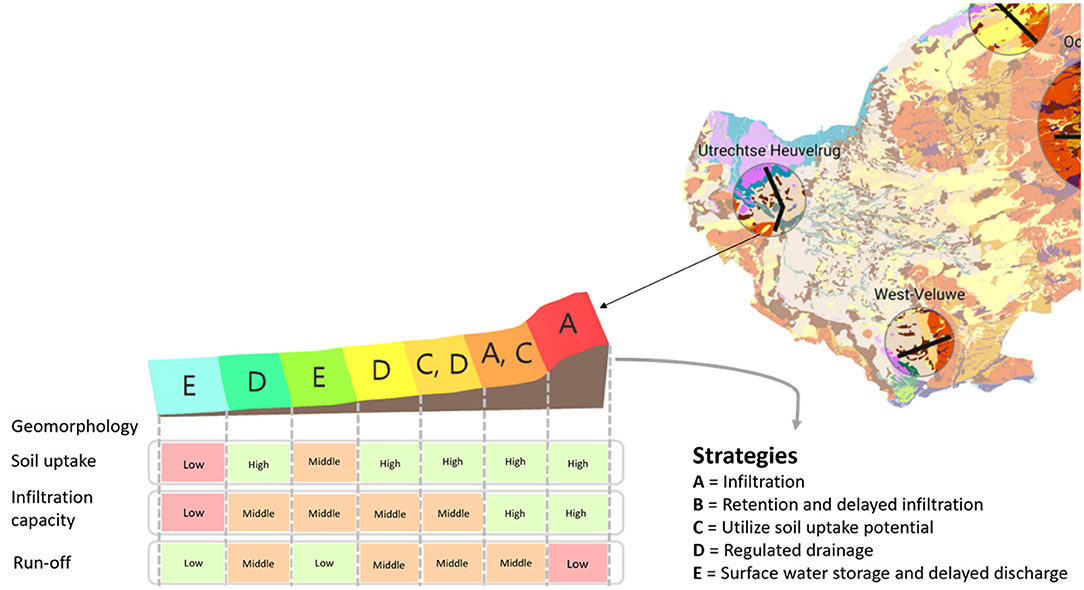
Figure 1. Klimaateffect Vallei en Veluwe (2020).
The system analysis approach was followed to provide insight into the DNA of the environment. Examples of analysis methods included amongst others landscape-based solutions, urban genes and various GIS analyses. The objective was to provide input for the (a) stress test, thus vulnerability of the environment to climate change, (b) the risk dialogue, thus explanations and logical arguments pertaining to opportunities and risks, and (c) the implementation strategy, thus formal planning measures for climate adaptation. The research results in Amersfoort indicated however that soil and ground surface vary throughout the area and a blueprint plan for the entire city would not be feasible. Scale of implementation would thus be limited to more homogenous geomorphological areas and opportunity maps should be custom-made of each of these areas.
Based on the DNA information specific opportunities and limitations were identified per area. In the event of extreme rainfall, the risks in terms of possible damaged areas were identified, as well as the areas that won't be at risk. The infiltration capacity on the lateral moraine was also identified and evaluated in case of extreme rainfall. In finding solutions to mitigate the impacts of the severe rainfall, it was investigated whether green roofs would be a suitable option and if green roofs implemented on different soil classes would have a bigger or lesser effect. In this sense the learn-by-do approach resulted in opportunity maps to identify the potential of green roofs in the area of Rhenen, supported by climate-robust design principles.
It became evident that soil and the subsurface data could indeed be a valuable tool to plan for climate adaptation in the city and the surrounding area. The success of this approach would however mainly be related to the availability of data, involvement of different target groups, the characteristics of the city and acknowledgment of the geomorphological differences per area. Available national data can be used but need to be translated to a local level and interpreted in terms of the climate adaptation objectives (either capturing or filtration of water).
Geomorphological data would thus be a critical indicator of possible nature-based solutions. It became evident that if spatial planning could optimize the use of soil and underground surfaces for the purposes of capturing or filtering water, it would also conform to broader climate adaptation objectives. It was evident that the DNA of the spatial environment, including the functioning of the natural system of soil, subsurface, landscape, water, and cultural history should play a much more prominent in forward planning approaches.
South Africa is a water scare country but currently still does not have water planning policy in place to enforce water sensitive planning approaches. Lephalale Local Municipality is situated within the Limpopo Province of South Africa, forming part of the administrative boundary of the Waterberg District Municipality. The municipality has three perennial rivers, including the Lephalala river, the Limpopo river which runs along the Botswana border, and the Mokolo river which splits the municipality in two, east and west (Rohr, 2019, p. 120). Approximately 39.13% of Lephalale's landscape is untouched and in a natural state. Only 0.56% of the municipality's surface area is covered by water bodies (Rohr, 2019, p. 120).
One hundred and fifty-three square kilometer of area within the case study delineation has high swelling clay potential and is currently predominantly used for cultivated commercial fields, pivots, and orchards and some plantation (Rohr, 2019, p. 169). A sum total of 23.6 km2 (currently comprising of agricultural, mining, and urban land uses) has impeded soil drainage and can be affected by flooding if heavy storms occur. Furthermore, 0.5 km2 of land is currently being used for public open space, which could potentially be Utilized for constructed wetlands within the built-up urban area.
The Groundwater Recharge Potential (GWRP) is relatively low throughout the northern region ranging between 0 and 99 mm/a; increasing toward the south where it ranges between 100 and 300 mm/a (Rohr, 2019, p. 170). According to the evidence based spatial assessment, 92.0 km2 of land are located within the moderate to high GWRP, but host agricultural, mining, and urban land uses which usually cause groundwater contamination, as illustrated in Figure 2.
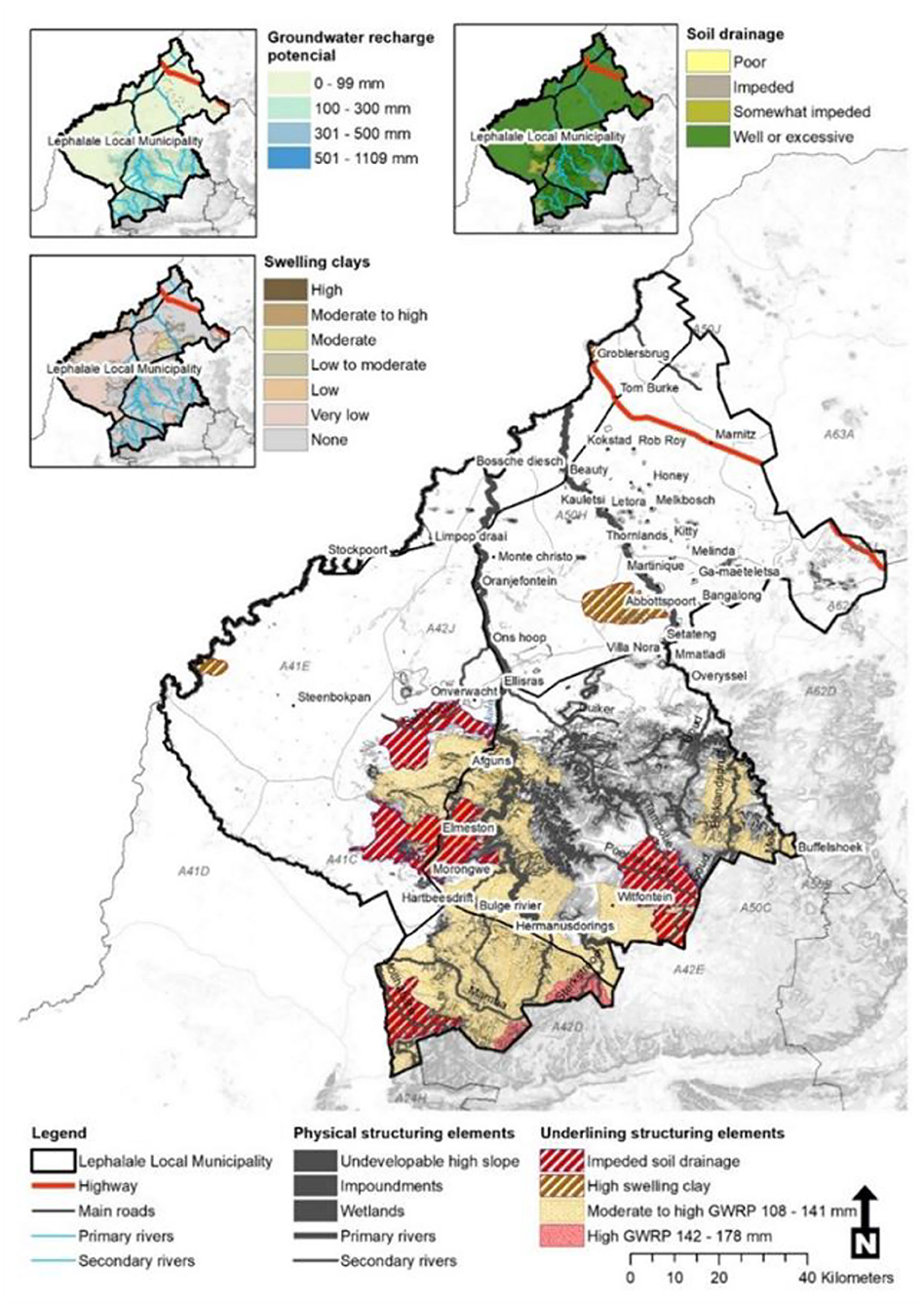
Figure 2. Lephalale's physical and underlining structuring elements. Source: Rohr, 2019, p. 170.
This case study considered the city-scale in terms of water availability. The total volume of available, renewable groundwater was quantified in terms of “utilizable groundwater exploration potential” allowing for factors such as physical constraints on extraction, portability, and a maximum allowable drawdown. It was evident that the utilizable groundwater exploration potential was highly irregular throughout Lephalale Local Municipality (Rohr, 2019, p. 178). A further evaluation was conducted in terms of the land use water quantity for Lephalale's formal built-up areas, calculated as an average annual consumption rate/volume (Rohr, 2019, p. 195). Taking the highly irregular utilizable groundwater and high demand for water into consideration, Rohr (2019, p. 195) investigated if rainwater harvesting would be a plausible solution to address water availability on this city-scale case study.
The calculation of rainwater harvesting potential of an individual site is relatively simple (Wilson, 2004), taking volume of useable rainwater, average rainfall over a period, area contributing to runoff (m2), run-off coefficient and filter efficiency into consideration. However, calculating the optimal rainwater harvesting potential for multiple stands or in this case for a city-scale, requires an innovative approach (Rohr, 2019, p. 193). To determine the volume of useable rainwater for an entire settlement, the following equation was used: AA = (ES × Cov) – vacant [Where: AA = Assumed area contributing to runoff (m2), ES = Erf Size (m2), Cove = % coverage as assigned by the land use scheme, vacant = all vacant stands used]. Daily rainfall data for the entire year, as obtained from the national Weather Services totalled to 228.2 mm. The land use data/cadastre, as well as the zoning and site sizes of all formally registered properties in the demarcated area, and the allowed coverage per land use were also considered. In Lephalale's case coverage for residential sites was set to 60% and for residential stands smaller than 350 m2 the maximum coverage was set to 50%. Therefore, the response to determine rainwater harvesting potential was adopted and referred to “assumed area contributing to runoff.” According to the calculation presented by Rohr (2019, p. 202) the case study in question could harvest a total volume of 882,887 L annually. Compared to existing consumption patterns, rainwater harvesting therefore only constitutes for 0.015% of the existing annual water demand (Rohr, 2019, p. 204). Rainwater harvesting is furthermore seasonal, which further limits the potential thereof to address water availability. Even though this approach to address water availability in the demarcated case study was considered flexible and innovative, it did not make a substantial contribution to water quantity and seasonal availability of water and called for an even more comprehensive approach.
In quest for securing better water availability, it was evident that a more comprehensive approach would be needed. Rainwater harvesting would not suffice as the only nature-based solution. In considering the broader spatial approach, it was evident that groundwater and the impact of development on groundwater resources has been ignored entirely in the spatial approach employed in Lephalale (Rohr, 2019, p. 170). Lephalale Local Municipality existing SDF (Lephalale Local Municipality, 2017) does not provide any information regarding the quantity or quality of surface water or groundwater resource, nor does it make any reference to the possible impact of land use on water resources (Rohr, 2019, p. 179). It is in this sense that this case study contributes to the call to upscale nature-based solutions as part of a comprehensive spatial planning approach. When considering the soil and geomorphological qualities of the demarcated case study, it is evident that there is potential to unlock.
According to the National Freshwater Ecosystem Priority Areas (NFEPA) spatial dataset several existing wetlands are located within close proximity, in relatively natural landscapes, forming groups of embedded wetland waterbodies (Rohr, 2019, p. 185). In total 66 Wetland Clusters covering 1,287 km2 of surface area are present within the catchment area (Lephalale Local Municipality, 2017). However, most wetland clusters in Lephalale Local Municipality are affected by agricultural activities toward the south-western region and informal settlement development toward the north-east. Spatial data revealed that 3,440 land parcels are in direct conflict with wetland clusters and another 7,072 land parcels are located within sensitive buffer zones (refer to Figure 3). While the majority of wetland clusters are still in ecological condition, it is evident from this case that broader spatial planning approaches could influence and support nature-based solutions radically. By adding 639 km2 to the municipalities existing Protected Areas Network, the proportion of ecologically sensitive areas under legal protection will increase by 13.6% (Rohr, 2019, p. 187).
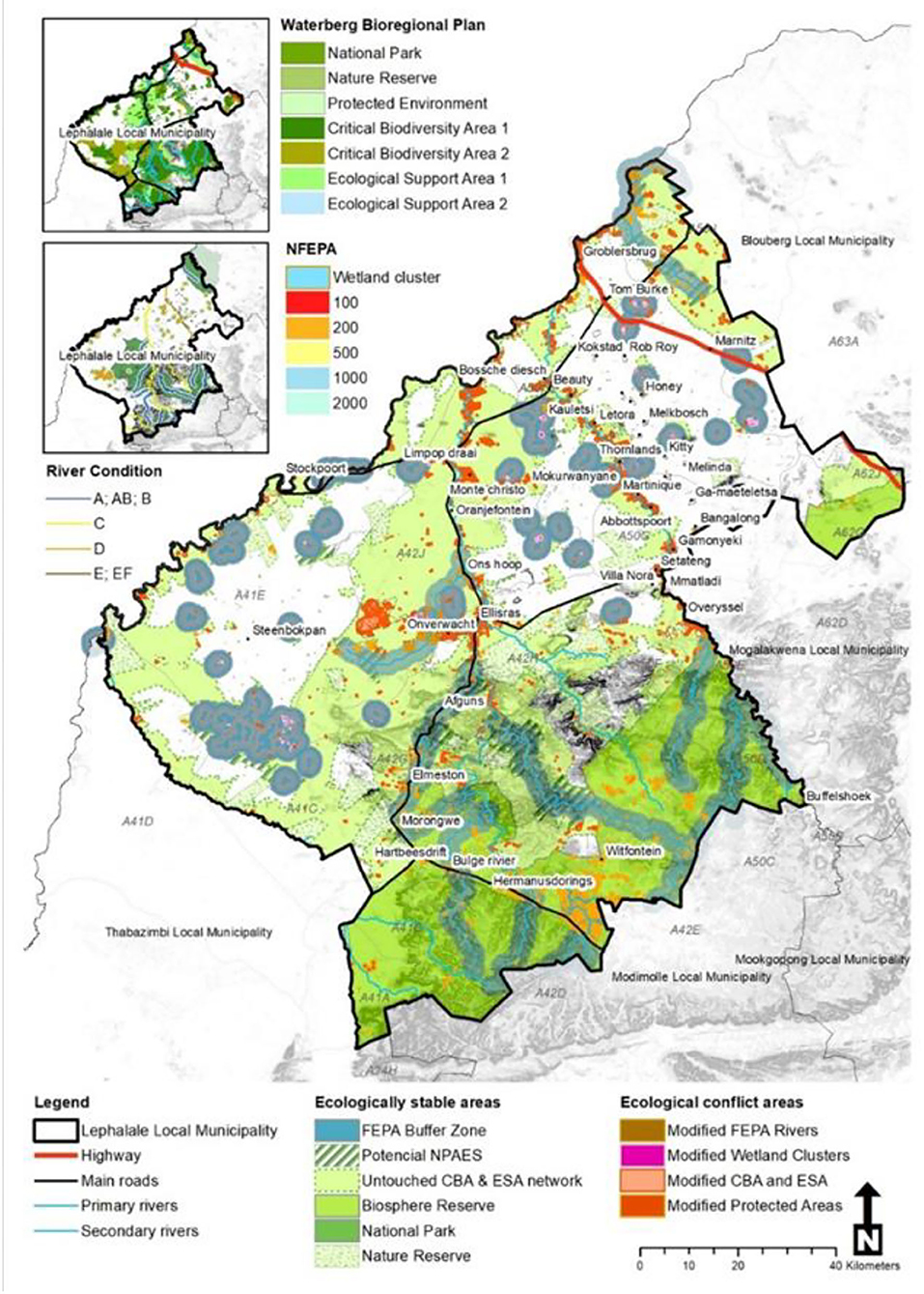
Figure 3. Environmental management requirements. Source: Rohr, 2019, p. 186.
If these ecological sensitive areas are considered together with geomorphological data, nature-based solutions could be enhanced. Sufficient groundwater planning should be included, emphasizing pockets of underground water storage potential throughout the case study area. If spatial planning could optimize the use of underground surfaces for the purposes of storing water and complement it with rain harvesting approaches, the total annual water availability in the area will be increased. It should also however, be aligned with relevant and approved land uses, to not contaminate ground water any further. In this sense, if nature-based solutions are optimized and scaled-up to a more comprehensive spatial plan, the groundwater recharge potential could be enhanced as evident from Lephalale Local Municipality case study.
A comparative analysis was conducted between the Amersfoort and Lephalale case studies in attempt to identify how nature-based approaches aligned with the objectives of climate adaptation planning. The comparative analysis considered climate adaptation objectives, as well as issues pertaining to biodiversity and urbanization, in response to identifying suitable nature-based solutions. The findings from the comparative analysis pose valuable considerations as point of departure for a more comprehensive approach to adaptation planning, as captured in Table 1.
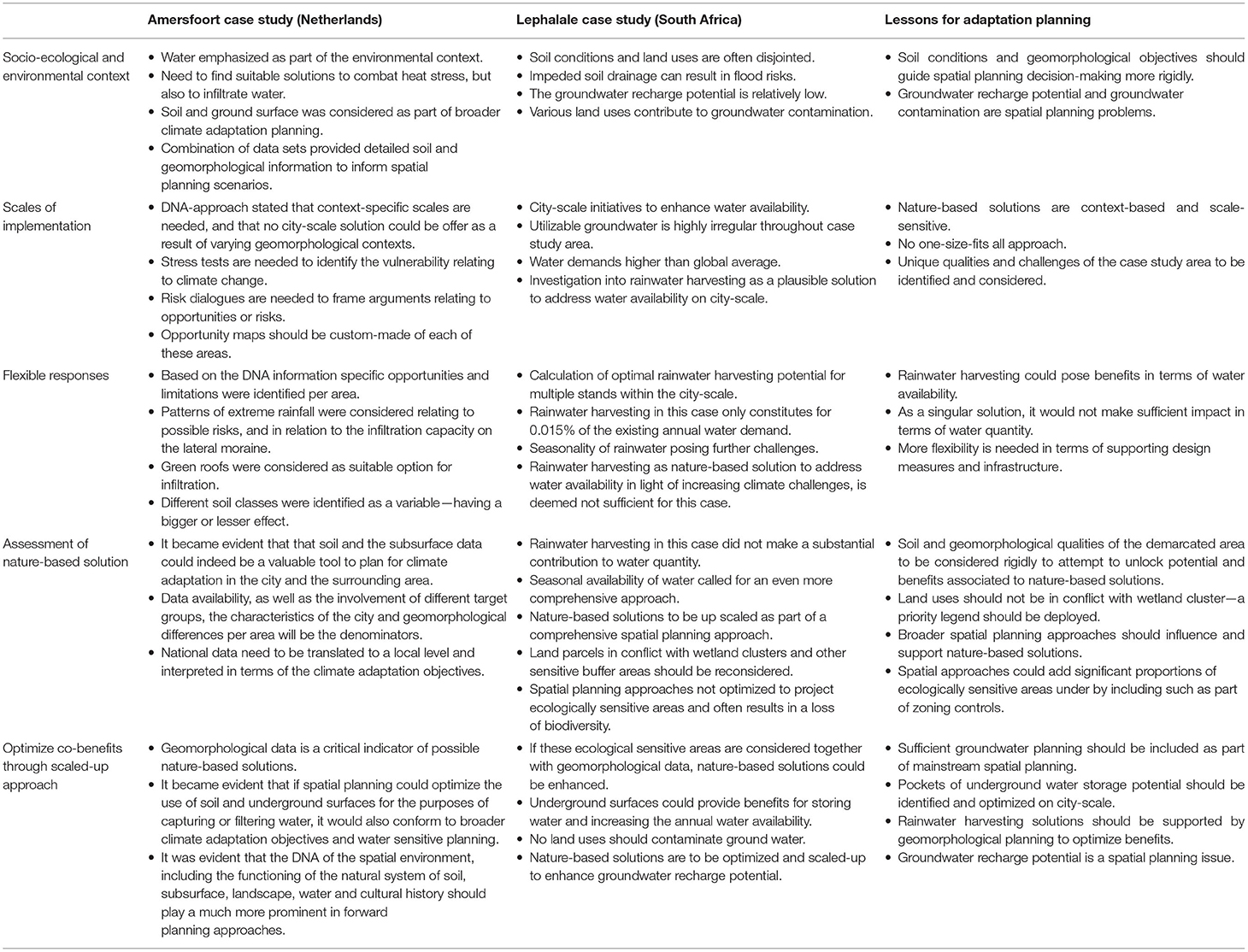
Table 1. Analysis of two case studies to inform climate adaptation planning.
The cases identified amongst others how the broader environment could benefit when nature-based solutions are scaled-up and addressed from a comprehensive manner. The findings, in context of adaptation planning, are considered accordingly.
Contemporary issues such as climate adaptation, biodiversity and urbanization are often viewed separately. To build a case to convince politicians, local authorities and decision-makers to invest in such nature-based activities, it should not only be about realizing climate adaptation objectives, but also about enhanced, biodiversity and addressing the broader impacts of urbanization on the natural environment. The case studies included in this research provided evidence of the interconnection between these concepts. However, in light of increasing urbanization across the globe, more efforts should be invested into creating flexible, novel approaches to mitigating the impacts of urbanization and associated climate change challenges. Throughout the literature review it became evident that groundwater is considered an “unknown resource” in terms of spatial planning approaches. Spatial planning and land use management policies barely ever include groundwater resources in spatial assessments or proposals, and groundwater recharge potential and its geological permeability is neglected from an urban planning perspective (Rohr, 2019, p. 169). Climate adaptation planning requires an integrative perspective, where the natural carrying capacity of an area are informing spatial planning, not the other way around.
Nature-based solutions are gaining importance in the discourse of successful adaptation planning approaches, but an ad hoc approach will not suffice. Although singular nature-based solutions could provide benefits to an urban environment and its host inhabitants, the two case studies captured in this research, proved that comprehensive, scaled-up approaches would be more beneficial and effective in terms of mitigating the effects of climate change. A comprehensive nature-based approach should take socio-ecological and environmental objectives into account, especially in terms of the design, but also recognize various scales of implementation and flexible responses. As this is novel ground for planners and policymakers, it would imply a learn-by-do approach, until adequate evidence has been collected and analyzed, to be able to put best practices forward.
Scaled-up nature-based approaches such as opportunity cards and infiltration probability maps of soil classifications should be employed to inform mainstream spatial planning and to optimize the benefits of the geomorphological context. Although there is no blueprint planning for such approach as the DNA of environments differ, the inclusion of more flexible and novel nature-based solutions, introduced as part of a learn-by-do approach, might be able to condense the evidence into best practice guidelines. The results of these learn-by-do approaches should be quantified, in order to expand the literature base and academic discourse on nature-based solutions. From this research and the two case studies presented, we conclude that nature-based solutions should be scaled-up and be more comprehensive to guide climate adaptation planning, possibly through:
• Comprehend the local natural system and including it as part of broader spatial planning approaches.
• Commit to update infrastructure (as per policy cycle periods) through nature-based solutions to ensure that within the next 20–50 years all cities will be adaptively greened and have an adaptive water system.
• Employ the DNA approach to ensure that context-based planning is employed and that opportunity cards are custom-made per area, to enhance the geomorphological benefits.
• Embrace adaptive planning approaches especially in areas with limited data availability.
The raw data supporting the conclusions of this article will be made available by the authors, without undue reservation.
All authors listed have made a substantial, direct, and intellectual contribution to the work and approved it for publication.
The authors declare that this study received funding from the Dutch Ministry of LNV and the Province of Gelderland. The funders had the following involvement in the program of the study: request to search for and reflect on concrete ideas on urban climate adaptation.
All claims expressed in this article are solely those of the authors and do not necessarily represent those of their affiliated organizations, or those of the publisher, the editors and the reviewers. Any product that may be evaluated in this article, or claim that may be made by its manufacturer, is not guaranteed or endorsed by the publisher.
Financial support were provided by Topsector Agri&Food, Netherlands in order to support collaboration between businesses, institutions and the government to find innovations in the field of sustainable production of healthy and safe food and the development of a healthy, green living environment.
Ahern, J. F. (2011). From Fail-Safe to Safe-to-Fail: Sustainability and Resilience in the New Urban World. Landscape Architecture & Regional Planning Studio and Student Research and Creative Activity. Retrieved from: https://scholarworks.umass.edu/larp_grad_research/8 (accessed August 07, 2017).
Araos, M., Berrang-Ford, L., Ford, J. D., Austin, S. E., Biesbroek, R., and Lesnikowski, A. (2016). Climate change adaptation planning in large cities: a systematic global assessment. Environ. Sci. Policy 66, 375–382. doi: 10.1016/j.envsci.2016.06.009
Association of African Planning Schools (2010). Guidelines for Case Study Research and Teaching. Cape Town: MegaDigital.
Barton, D., Ring, I., and Rusch, G. (2017). Policy Mixes: Aligning instruments for biodiversity conservation and ecosystem service provision. Environ. Policy Govern. 27, 397–403. doi: 10.1002/eet.1779
Bulkeley, H., and Tuts, R. (2013). Understanding urban vulnerability, adaptation and resilience in the context of climate change. Local Environ. 18, 646–662. doi: 10.1080/13549839.2013.788479
Cohen-Shacham, E., Walters, G., Janzen, C., and Maginnis, S. (2016). Nature-Based Solutions to Address Global Societal Challenges. Gland: IUCN. doi: 10.2305/IUCN.CH.2016.13.en
De Ridder, D. W. (2019). Considering nature-based solutions for place-branding: a spatial planning perspective (Masters dissertation), North-West University, Potchefstroom.
Doak, D. F., Bakker, V. J., Goldstein, B. E., and Hale, B. (2015). What is the future of conservation?. Trends Ecol. Evol. 29, 77–81. doi: 10.1016/j.tree.2013.10.013
European Environmental Agency (2016). Climate Change, Impacts and Vulnerability in Europe 2016. An Indicator-Based Report. EEA Report No 1/2017, 8–334.
Faivre, N., Fritz, M., Freitas, T., de Boissezon, B., and Vandewoestijne, S. (2017). Nature-Based Solutions in the EU: Innovating with nature to address social, economic and environmental challenges. Environmental Research 159, 509–518. doi: 10.1016/j.envres.2017.08.032
Fink, H. S. (2017). Human-nature for climate action: nature-based solutions for urban sustainability. Sustainability 8, 254–274. doi: 10.3390/su8030254
Gemeente Amersfoort (2020). Amersfoort. Available online at: https://www.amersfoort.nl/contact.htm (accessed: July 10, 2020).
Gibbs, M. (2015). Guiding principles for infrastructure climate change risk and adaptation studies. Civil Eng. Environ. Syst. 32, 206–215. doi: 10.1080/10286608.2015.1025385
Hartig, T., Mitchell, R., de Vries, S., and Frumkin, H. (2014). Nature and health. Ann. Rev. Public Health 35, 207–228. doi: 10.1146/annurev-publhealth-032013-182443
Hu, X., Hall, J. W., Shi, P., and Lim, W. H. (2016). The spatial exposure of the Chinese infrastructure system to flooding and drought hazards. Nat. Hazards 80, 1083–1118. doi: 10.1007/s11069-015-2012-3
Kennedy, D., Stocker, L., and Burke, G. (2010). Australian local government action on climate change adaptation: some critical reflections to assist decision-making. Local Environ. 15, 805–816. doi: 10.1080/13549839.2010.514602
Klimaateffect Vallei en Veluwe (2020). Klimaatatlas. Available online at: https://klimaatvalleienveluwe.nl/ (accessed July 10, 2020).
Lephalale Local Municipality (2017). Lephalale Local Municipality Spatial Development Framework. Lephalale Local Municipality Department of Urban Planning.
Liquete, C., Udias, A., Conte, G., Grizzetti, B., and Masi, F. (2016). Integrated valuation of a nature-based solution for water pollution control. Highlighting hidden benefits. Ecosyst. Serv. 22, 392–401. doi: 10.1016/j.ecoser.2016.09.011
Moore, T. S., Lapan, S. D., and Quartaroli, M. T. (2012). “Case study research,” in Qualitative Research: An Introduction to Methods and Sesign, eds S. D. Lapan, M. T. Quartaroli, and F. J. Riemer (San Francisco, CA: Jossey-Bass), 243–270.
Nesshöver, C., Assmuth, T., Irvine, K. N., Rusch, G. M., Waylen, K. A., Delbarere, B., et al. (2017). The science, policy and practice of nature-based solutions: an interdisciplinary perspective. Sci. Total Environ. 579, 1215–1227. doi: 10.1016/j.scitotenv.2016.11.106
Peter, B., Mungai, L., Messina, J., and Snapp, S. (2017). Nature-based agricultural solutions: scaling perennial grains across Africa. Environ. Res. 159, 283–290. doi: 10.1016/j.envres.2017.08.011
Radhakrishnan, M., Pathirana, A., Ashley, R. M., Gersonius, B., and Zevenbergen, C. (2018). Flexible adaptation planning for water sensitive cities. Cities 78, 87–95. doi: 10.1016/j.cities.2018.01.022
Raymond, C., Frantzeskaki, N., Kabisch, N., Berry, P., Breil, M., Nita, M., et al. (2017). A framework for assessing and implementing the co-benefits of nature-based solutions in urban areas. Environ. Sci. Policy 77, 15–24. doi: 10.1016/j.envsci.2017.07.008
Revi, A., Satterthwaite, D., Aragón-Durand, F., Corfee-Morlot, J., Kiunsi, R. B., Pelling, M., et al. (2014). Towards transformative adaptation in cities: the IPCC's Fifth assessment. Environ. Urban. 26, 11–28. doi: 10.1177/0956247814523539
Rohr, H. E. (2019). Water Sensitive Planning: An integrated approach towards sustainable urban water system planning in South Africa (Doctoral dissertation), North-West University, Potchefstroom.
Steiner, F. R. (2006). “Metropolitan resilience: the role of universities in facilitating a sustainable metropolitan future,” in Toward a Resilient Metropolis, eds A. C. Nelson, B. L. Allen, and D. L. Trauger (Alexandria, VA: Metropolitan Institute Press), 1–18.
Swanborn, P. G. (2010). Case Study Research: What, Why and How? London: SAGE Publications Ltd. doi: 10.4135/9781526485168
Thomas, K., and Littlewood, S. (2010). From green belts to green infrastructure? The evolution of a new concept in the emerging soft governance of spatial strategies. Plan. Pract. Res. 25, 203–222. doi: 10.1080/02697451003740213
Wezel, A. (2019). Towards climate adaptation as the new normal: analysis and evaluation of the governance capacity for climate adaptation in two regional networks in the Netherlands (Master's thesis), University of Utrecht, Utrecht.
Wilson, S., Bray, R., and Cooper, P. (2004). Sustainable Drainage Systems: Hydraulic, Structural and Water Quality Advice. CIRIA. Available online at: http://www.ciria.org.uk/suds/publications.html (accessed August 07, 2017).
Keywords: nature-based solutions, climate adaptation, planning, evidence-based, context-based
Citation: Cilliers EJ, Timmermans W, Rohr H and Goosen H (2022) Scaling Up of Nature-Based Solutions to Guide Climate Adaptation Planning: Evidence From Two Case Studies. Front. Sustain. Cities 4:624046. doi: 10.3389/frsc.2022.624046
Received: 30 October 2020; Accepted: 16 February 2022;
Published: 12 April 2022.
Edited by:
Dagmar Haase, Humboldt University of Berlin, GermanyReviewed by:
Heriberto Cabezas, University of Miskolc, HungaryCopyright © 2022 Cilliers, Timmermans, Rohr and Goosen. This is an open-access article distributed under the terms of the Creative Commons Attribution License (CC BY). The use, distribution or reproduction in other forums is permitted, provided the original author(s) and the copyright owner(s) are credited and that the original publication in this journal is cited, in accordance with accepted academic practice. No use, distribution or reproduction is permitted which does not comply with these terms.
*Correspondence: Elizelle Juanee Cilliers, anVhbmVlcEBnbWFpbC5jb20=
Disclaimer: All claims expressed in this article are solely those of the authors and do not necessarily represent those of their affiliated organizations, or those of the publisher, the editors and the reviewers. Any product that may be evaluated in this article or claim that may be made by its manufacturer is not guaranteed or endorsed by the publisher.
Research integrity at Frontiers
Learn more about the work of our research integrity team to safeguard the quality of each article we publish.