- 1School of Architecture and Civil Engineering, Chengdu University, Chengdu, Sichuan, China
- 2School of Civil Engineering, Sichuan University of Science and Engineering, Zigong, China
- 3School of Civil Engineering, Nanyang Institute of Technology, Nanyang, Henan, China
The risk assessment of landslide hazards has a tremendous influence on people’s lives and property safety; therefore, its investigation is significant. The stratigraphic lithology, degree of weathering, relationship between the structural plane and slope direction, cohesive force, angle of internal friction, severity, average slope degree, height of slope, and type of landslide are adopted as the evaluation factors first. Second, an assessment model is developed based on the variable fuzzy set theory. In addition, the proposed model is utilized to assess the landslide hazards in the Badong section of Three Georges in China. Finally, the results demonstrate that the results derived from the proposed model are consistent with the current specifications; the accuracy rate reaches 83%. The method can determine the risk level of landslide hazards and provide an alternative scheme. Hence, this study can accurately present a new approach for assessing landslide hazards in the future.
1 Introduction
A landslide is a disaster that frequently occurs [1]. Its area of impact can be extensive and very destructive [2]. Landslides can cause massive damage to local infrastructure and even threaten the safety of people [3, 4].
Landslide hazards often occur in the Three Gorges Reservoir area. Until November 2003, landslide hazards occurred 4,638 times, and several thousand landslide hazards could not be controlled according to the relevant statistics [5, 6]. Therefore, how to lessen the economic losses and casualties arising from landslide hazards has become an important issue [2, 7]. The accurate risk level of landslide hazards in the Three Gorges Reservoir area is significant.
Research on the risk assessment and prediction of landslide hazards has become a hot issue [8]. For example, slope, precipitation, and human activities are adopted as the assessment index. Gao et al. [9] assessed the risk level of landslide hazards in the Wanzhou zone, Chongqing, China. Wang et al. [10] established three nonlinear prediction models based on the weight of the joint prediction model to assess the risk level of the Qinglong landslide in Guizhou. Liu et al. [11] performed an investigation on the risk and vulnerability evaluation of landslide hazards in the bank section of the reservoir. Men et al. [12] investigated the reasons for and mechanisms of the Baijia Bao landslide based on geological surveys and rainfall data using numerical simulations in combination with actual monitoring data. Shi et al. [13] analyzed the risk assessment of landslide hazards using GIS technology with existing applications to improve the precision of the evaluation method. Spatial prediction of landslide hazards was investigated using the information model and quantitative analysis, multifactor regression analysis model, and fuzzy discriminant analysis model by Huang et al. [14]. Gu et al. [15] analyzed the landslide hazards in Shiwangmiao, Chongqing, using the intuitionistic fuzzy set-TOPSIS model.
With the development of science and technology, many methods have been used to evaluate landslide hazards, such as the catastrophe theory model [16, 17], neural network model [18], fuzzy comprehensive evaluation, and gray correlation analysis model [19]. The aforementioned methods have fostered the development of an evaluation model for landslide hazards. However, deficiencies still exist [20, 21], such as the complex calculation process and the quantitative or qualitative analytical results [22–24].
To conquer the insufficiency of the aforementioned theories, the variable fuzzy set theory is introduced to assess the risk level of landslide hazards. The method has many merits, such as its algorithm is precise, its operability is very strong in reality, and the grading standards, which are interval forms, can be solved well. For the proposed model, the construction of the relative difference function is depicted as quantitative tools of variable fuzzy sets. It describes the essence for contradictions and unity of opposites of movement and the change criterion about the objective things. The theory confirms the principle of dialectics of nature; therefore, the model improves the traditional fuzzy set model enormously.
This paper is organized as follows: in Section 2, the study area is correlated first; Section 3 presents a new assessment model based on the proposed method ; Section 4 explores the construction of the evaluation model of landslide hazards; Section 5 presents the analysis of the evaluation results derived from the proposed method; and Section 6 summarizes the conclusions.
2 Study area
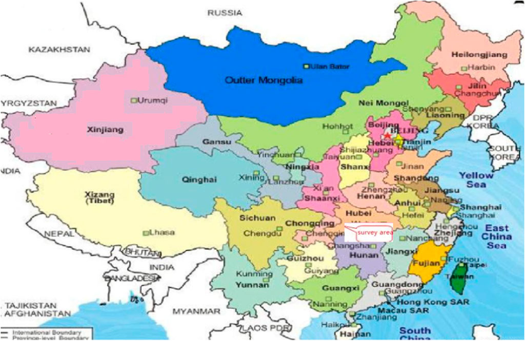
The Three Gorges Reservoir area is located at 28°32′∼31°44′ North and 105°44′∼31°44′ East. The total length of backwater in the mainstream is 662.9 km. It includes Badong County on the Yangtze River. Badong County is located in southwestern Hubei Province in China and contains the middle and upper streams of the Yangtze River watershed. It is located in Enshi Tujia and Miao Autonomous Prefecture. Its width from east to west is 10.3 km; its length from north to south is 135 km; its total area reaches 3,354 km2; and the survey area is shown in Figure 1.
The soil material in the landslide is mainly silty clay with crushed stone and crushed stone soil distributed in the whole slide body. The slippage soil is mainly silty clay with gravel breccia. The thickness of the slip band is 0.2 cm. The extraordinary phenomenon of deep slip zone soil is not apparent, but it has less breccia.
The material of the slide bed consists mainly of feldspar quartz sandstone and mudstone of the Jurassic Badong Formation. The occurrence of the bedrock is 260° < 30°. The bedrock surface undulates little and is close to the ground. According to the strata, the slope is reversed.
3 Methodology
Entropy theory and the variable fuzzy set assessment method are combined to develop a comprehensive approach for land hazard assessment. It can depict the inconsistent conception and implication of membership and non-membership functions dynamically; therefore, it is the significant optimization of traditional fuzzy sets.
3.1 The basic definition
Assuming that
In the domain
Figure 2 depicts the dynamic variable of any number in any closed interval as follows:
The relative membership degree of
where
The attractive and repelled sets
When
Figure 4 shows the relative difference function of
3.2 Determining the relative membership degree
where
When we enlarge the set
Based on the relevant Ref. [26], the level standard
where the element
when
Therefore, their relative membership degree is depicted in Eqs. 11, 12.
3.3 Determining index weights
(1) It is assumed that sample set
(2) Sample set
3.3.1 The positive index:
3.3.2 The negative index:
where
(3) Determining the proportion of the assessment index.
(4) The entropy is calculated in Eq. 17:
(5) The final weight can be depicted in Eq. 18:
3.4 Determining the evaluation grade
According to Eqs. 11, 12, and 18 and in combination with the relevant Ref. [26], a synthetic membership degree is shown in Eq. 19:
Based on Eq. 19, the synthetic membership degree is calculated as follows:
where
The evaluation grade
3.5 The calculative step and the flow chart
Its calculative process is correlated as follows:
(1) According to the specific data and evaluation standard, the eigenvalue matrix
(2) The attractive domain
(3) Based on Eqs. 11, 12, the relative membership degree is calculated.
(4) The weights of the landslide hazards using the proposed model are calculated.
(5) The grade eigenvalues
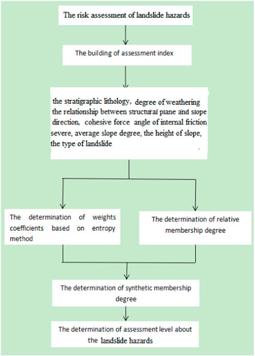
Its flow chart is plotted in Figure 6. First, a complete evaluation index system should be constructed before the risk level of landslide hazards is evaluated. Second, entropy–weight theory is adopted to calculate the weight of each evaluation index. Third, the relative membership degree is defined based on the proposed model. Then, the proposed model can determine the risk level of landslide hazards.
4 Construction of the evaluation model
4.1 Determining evaluation indices
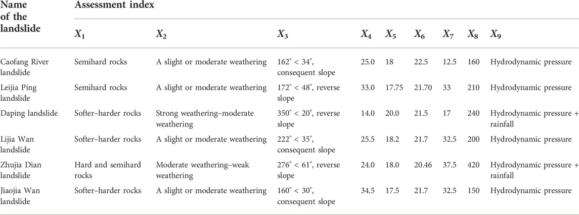
The Caofang River landslide, Leijia Ping landslide, Daping landslide, Lijia Wan landslide, Zhujia Dian landslide, and Jiaojia Wan landslide in the Badong sections of the Three Gorges Reservoir area are selected as the assessment objects. According to the characteristics of landslides in the Three Gorges Reservoir area, the stratigraphic lithology (X1), degree of weathering (X2), relationship between the structural plane and slope direction (X3), cohesive force (X4), angle of internal friction (X5), severity (X6), average slope degree (X7), height of slope (X8), and type of landslide (X9) are selected as assessment indices. Their original values are shown in Table 1 [27].
It can be found in Table 1 that X1, X2, X3, and X9 are qualitative and the other indices are quantitative. To assess the risk level of landslides, the quantitative indices should be transformed into qualitative indices. According to the hierarchy method, the quantitative indices are divided into five groups: excellent, good, moderate, bad, and very bad. The five grades are 5, 4, 3, 2, and 1, respectively. Table 2 is as follows:
According to extensive statistics and analysis and in combination with the geological conditions of assessment objects [16, 28], the risk level of landslides is classified into five classes: safe (I), mildly dangerous (II), dangerous (III), more dangerous (IV), and hazardous (V). Their classification standards are shown in Table 3.
4.2 Determination of the risk level of the landslide hazard
(1) The construction of the attractive domain, range matrix, and point value matrix.
According to Table 3 and in combination with Eq. 7, the attractive domain
Based on Eq. 8, the matrix
Based on Eq. 10, the point value matrix
(2) Determining the relative membership degree
Based on Table 2 and in combination with Eqs. 11, 12, we should decide whether the evaluation magnitudes are to the left or the right of point
When
In the same way, the relative membership degree matrix of the Caofang River landslide can be obtained as follows:
(3) Determining weight coefficients
Based on Table 2 and in combination with Eq. 16, Table 4 shows the parameter matrix.
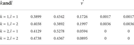
According to Table 4 and Eq. 17, the entropy matrix can be shown in Table 5.
According to Eq. 18, the weight coefficients are shown in Table 6.
(4) Determination of the comprehensive relative membership degree
Based on Eq. 19 and
Based on Eqs. 20, 21, the comprehensive relative membership degree matrix is normalized in Table 8.
(5) Determining the risk level of the landslide hazards.
According to Eq. 22 and Table 8, the ranking value of the Caofang River landslide is shown in Table 9.
Similarly, the feature values of the other five landslides are shown in Table 10.
The results obtained from different methods are contrasted in Table 11.
The variable fuzzy set assessment method is used to evaluate the risk level of landslide hazards. Their complete results are shown in Table 10. Table 10 shows that the risk levels of landslide hazards of six different landslides are different. The risk level of the Daping landslide and Lijia Wan landslide is III and that of the rest of the landslides is II. This indicates that the risk level of the Daping landslide and Lijia Wan landslide is dangerous and that of the rest of the landslides is mildly dangerous. Therefore, the necessary consolidation measurements should be performed at the Daping landslide and Lijia Wan landslide. The qualified rate of landslide hazards in all the Badong section of Three Gorges is 67%.
Based on the analytical results of the evaluation method in Table 11, the conclusions obtained from the proposed model are consistent with the site investigations of the five landslides, except for the Zhujia Dian landslide. Its accuracy is 83% in the proposed model, which is higher than that (50%) while using the gray fuzzy comprehensive evaluation theory [27] and that while using level-based weight assessment (67%). In comparison with gray fuzzy comprehensive evaluation theory, the variable fuzzy set assessment method can accurately transmit the risk degree of landslide hazards. Therefore, the conclusions indicate that estimating the risk level of landslide hazards is feasible using the proposed method. Accurate results and details of landslide hazards were obtained. For example, the cohesive force of the Lijia Ping landslide is 33, which should be Grade I based on Table 3. In addition, the membership degree of the other indices obtained by the proposed method is Grade II; therefore, the grade probability of the Lijia Ping landslide at Grade II is more extensive than that at Grades I, IV, III, and V. The risk level probability of the Lijia Ping landslide must be Level II and almost impossible is Level I, IV, III, and V. The risk grade of the Zhujia Dian landslide possibly belongs to Grade III, which is more than that of the Lijia Wan landslide, because the mean ranking feature value (3.1773) of the Zhujia Dian landslide, Level III, is higher than that of the Lijia Wan landslide (2.8162). The conclusions obtained using the proposed method demonstrate the accuracy of the risk level and further determine the ranking of landslide hazards for different landslides at the same grade.
5 Discussion
5.1 Comparison with existing studies
The variable fuzzy set method is provided to assess the risk level of landslide hazards, and the results are good. However, due to a lack of information, the uncertain human mind, and time complexity, decision experts (DEs) cannot provide accurate results for subjective methods such as the gray fuzzy comprehensive evaluation method and level-based weight assessment (LBWA). While the proposed model addresses this concern, it not only considers the unreliability or reliability of the problem but also solves some degrees of uncertainty and ambiguity of the data. Therefore, it has significant advantages over these subjective methods.
5.2 The advantages and limitations of the proposed model
In comparison with the traditional models, the advantages of the variable fuzzy set theory are analyzed as follows:
(1) The variable fuzzy set method can accurately demonstrate the risk degree of landslide hazards using the eigenvalue of level H.
(2) Interval-oriented evaluation, not point assessment, is applied in the proposed model; therefore, the reliability of evaluation outcomes is enhanced, and the quality state of landslide hazards can be discovered with effect.
6 Conclusion
Considering the stratigraphic lithology (X1), degree of weathering (X2), relationship between the structural plane and slope direction (X3), cohesive force (X4), angle of internal friction (X5), severity (X6), average slope degree (X7), height of slope (X8), and type of landslide (X9), the variable fuzzy set theory is applied to evaluate the risk level of landslide hazards in the study.
The conclusions demonstrate that the outcomes obtained using the proposed model are consistent with the site investigations; its accuracy rate reaches 83%. The acceptance rate of landslide hazards for all landslides in the Badong section of Three Gorges is 67%. The proposed method further determines the risk ranking of landslide hazards of different landslides at the same grade. It can accurately demonstrate the risk degree of landslide hazards. Relative to the conventional model, its evaluation process is more reliable and efficient. However, it still has some drawbacks, such as complicated calculation and necessary multiple variable parameters; therefore, it still has significant room for improvement in the future.
In summary, the variable fuzzy set model could offer an alternate route to precisely evaluate the risk grade of landslide hazards.
Data availability statement
The original contributions presented in the study are included in the article/Supplementary Material; further inquiries can be directed to the corresponding author.
Author contributions
YL provided the method and wrote the manuscript; Y-HW provided Figures 1, 2; Q-HW provided Figure 3. X-BG provided the rest work.
Funding
This work is supported by the mineral resources project of Sichuan province (SCKCZY2022-ZC003), the cross project in the Nanyang Institute of Technology (520009), the start-up Foundation (510126), the Sichuan Science and Technology Program (No: 2020YJ0424), Regional Innovation Cooperation Programs of Sichuan Province (2021YFQ0050), Guizhou Provincial Science and Technology Projects [No. (2020)2004], the Scientific and Technological Projects of Henan Province (No: 222102320296), and the Opening Project of Sichuan Province University Key Laboratory of Bridge Non-destruction Detecting and Engineering Computing (2022QYJ02).
Conflict of interest
The authors declare that the research was conducted in the absence of any commercial or financial relationships that could be construed as a potential conflict of interest.
Publisher’s note
All claims expressed in this article are solely those of the authors and do not necessarily represent those of their affiliated organizations, or those of the publisher, the editors, and the reviewers. Any product that may be evaluated in this article, or claim that may be made by its manufacturer, is not guaranteed or endorsed by the publisher.
References
1. Gu XB, Wu ST, Ji XJ, Zhu YH. The risk assessment of debris flow hazards in Banshanmen gully based on the entropy weight normal cloud method. Adv Civil Eng (2021) 2021:1–11. doi:10.1155/2021/8841310
2. Gu XB, Wu QH. Seismic stability analysis of waterfront rock slopes using the modified pseudo-dynamic method. Geotech Geol Eng (2019) 37(3):1743–53. doi:10.1007/s10706-018-0718-1
3. Gu X-B, Wang L, Wu Q-H. The risk assessment of debris flow in the duba river watershed using intuitionistic fuzzy sets: TOPSIS model. Math Probl Eng (2022) 2022:1–12. Article ID 2031907, 12 pages. doi:10.1155/2022/2031907
4. Chen J, Shou Y, Zhou X. Implementation of the novel perfectly matched layer element for elastodynamic problems in time-domain finite element method107054. Soil Dyn Earthquake Eng (2022) 152.
5. Gu XB, Wu QH, Zhu YH. The experimental investigation on the propagation process of crack for brittle rock similar material. Geotech Geol Eng (2019) 37(6):4731–40. doi:10.1007/s10706-019-00934-w
6. Gu XB, Shao JL, Wu ST, Wu QH, Bai H. The risk assessment of debris flow hazards in zhouqu based on the projection pursuit classification model. Geotech Geol Eng (Dordr) (2021) 8:1267–79. doi:10.1007/s10706-021-01961-2
7. Gu X-B, Wu Q-H, Ma Y. Risk assessment of the rockburst intensity in a hydraulic tunnel using an intuitionistic fuzzy sets-TOPSIS model. Adv Mater Sci Eng (2022) 2022:1–14. doi:10.1155/2022/4774978
8. Gu CZ, Yang HF, Hu XW. Analysis of energy conversion of earthquake-induced landslide based on fuzzy synthetic evaluation. Rock Soil Mech (2012) 33(S1):297–302.
9. Gao C, Cui X. Landslide risk assessment based on multi-index weighted grey target decision model[J]. J Cent South Univ (2018) 47(2):524–5292007.
10. Wang W-d, Qu X, Liu P. Prediction on landslide displacement using a combination model with optimal weight. [J] J Catastrophology (2018) 33(1):59–64. doi:10.3969/j.issn.1000-811X.2018.01.012
11. liu L. Assessment of landslide risk along Wanzhou area in three Georges Reservoir[D]. Wuhan,China: China University of Geosciences (2016).
12. Men M. Analysis of deformation mechanism of baijiabao landslide in three Georges reservoir area[J]. J China Three Georges Univ (2017) 39:243–7.
13. Shi J, Xu R, Shi L. ETM+ imagery and GIS-based landslide susceptibility mapping for the regional area of Geheyan reservoir on the Qingjiang River, Hubei Province, China. EarthScience Front (2007) 14(6):119–28.
14. Huang ZM, Fu B, Chen Y. Aeration and hydrodynamic pressure characteristics for outer convex step in steep slope section. J Water ResourcesWater Eng (2018) 29(3):138–43. In Chinese.
15. Gu XB, Ma Y, Wu QH, Ji XJ, Bai H. The risk assessment of landslide hazards in Shiwangmiao based on intuitionistic fuzzy sets-Topsis model. Nat. Hazards (2022) 111(1):283–303.
16. Zhou XP, Zhang YX, Ha QL, Zhu KS. Micromechanical modelling of the complete stress–strain relationship for crack weakened rock subjected to compressive loading. Rock Mech Rock Eng (2008) 41(5):747–769. doi:10.1007/s00603-007-0130-2
17. Zhou XP, Gu XB, Qian QH. Seismic bearing capacity of shallow foundations resting on rock masses subjected to seismic loads. KSCE J Civ Eng (2016) 20(1):216–28. doi:10.1007/s12205-015-0283-6
18. Wang XT, Li SC, Ma XY, Xue YG, Hu J, Li Z. Risk assessment of rockfall hazards in a tunnel portal section based on normal cloud model. Pol J Environ Stud (2017) 26:2295–306. doi:10.15244/pjoes/68427
19. Ye BM, Li XW, Zhang JH. Study on artificial network method of surrounding rocks classification for hydraulic tunnel. Water resource & Hydropower of Northeast (2003) 8:53–5. (in Chinese).
20. Zhao Y, Bi J, Wang C, Liu P. Effect of unloading rate on the mechanical behavior and fracture characteristics of sandstones under complex triaxial stress conditions. Rock Mech Rock Eng (2021) 54:4851–66. doi:10.1007/s00603-021-02515-x
21. Gu XB, Wu QH. The application of nonordinary, state-based peridynamic theory on the damage process of the rock-like materials. Math Probl Eng (2016) 3(8):1–9. doi:10.1155/2016/9794605
22. Wang L, Liu Y, Li M. Time-dependent reliability-based optimization for structural-topological configuration design under convex-bounded uncertain modeling. Reliability Eng Syst Saf (2022) 221:108361. doi:10.1016/j.ress.2022.108361
23. Wang L, Liu J, Yang C, Wu D. A novel interval dynamic reliability computation approach for the risk evaluation of vibration active control systems based on PID controllers. Appl Math Model (2021) 92:422–46. doi:10.1016/j.apm.2020.11.007
24. Liu Y, Wang L, Gu K, Li M. Artificial neural network (ANN) - bayesian probability framework (BPF) based method of dynamic force reconstruction under multi-source uncertainties,Knowledge-based systems (2022) 237, 107796.
25. Wang Wc., Xu DM, Lei KW, Lei GJ. Assess river Water Qual based Theor variable fuzzy sets fuzzy binary comparison methodWater Resour Manage (2014) 28(12):4183–200.
26. Wang YK, Sheng D, Wang D, Ma H, Wu J, Xu F. Variable fuzzy set theory to assess water quality of the meiliang bay in taihu lake basin. Water Resour Manage (2014) 28(3):867–80. doi:10.1007/s11269-014-0521-6
27. Wang C, Li W. Application of grey relational fuzzy comprehensive evaluation method to landslide risk assessment in Badong section of three Georges reservoir area[J]. Water Resour Power (2019) 37(4):131–5.
Keywords: risk assessment, landslide hazards, variable fuzzy sets, Three Gorges Reservoir area, evaluation index
Citation: Li Y, Wang YH, Wu QH and Gu XB (2022) The risk assessment of landslide hazards in the Badong section of Three Gorges using the variable fuzzy set theory. Front. Phys. 10:1006840. doi: 10.3389/fphy.2022.1006840
Received: 29 July 2022; Accepted: 02 November 2022;
Published: 18 November 2022.
Edited by:
Irasema Alcántara-Ayala, National Autonomous University of Mexico, MexicoCopyright © 2022 Li, Wang, Wu and Gu. This is an open-access article distributed under the terms of the Creative Commons Attribution License (CC BY). The use, distribution or reproduction in other forums is permitted, provided the original author(s) and the copyright owner(s) are credited and that the original publication in this journal is cited, in accordance with accepted academic practice. No use, distribution or reproduction is permitted which does not comply with these terms.
*Correspondence: X. B. Gu, MTU4MjM0MDU5NTJAMTYzLmNvbQ==
 Y. Li1
 X. B. Gu


