- 1Key Laboratory of Terrestrial Surface Pattern and Simulation, Institute of Geographic Sciences and Natural Resources Research, Chinese Academy of Sciences, Beijing, China
- 2University of Chinese Academy of Sciences, Beijing, China
Coastal regions stand as pivotal zones of interaction between the marine and terrestrial environments, holding substantial significance for both ecosystems and human societies. Since the 1980s, China’s coastal zones (CCZ) have undergone rapid economic expansion, a surge in urban development activities, and a considerable population increase, instigating significant alterations in land use along the coast. However, in recent years, studies regarding changes in land use along China’s coastal zones have been notably scarce. Utilizing the Comprehensive Lands Cover Database (CLCD) dataset, this study scrutinized the spatiotemporal patterns of land use along the Chinese coastline since 1985. It delved into the temporal and spatial variations in land use, ecological land transformations, and the spatiotemporal evolution of land use development intensity, examining these facets across provinces, municipalities, and different distance bands from the coastal zone. The research findings indicated: Overall, cropland and forest land predominantly occupied coastal zones, encompassing over 80% of the total area. Between 1985 and 2020, the primary changes involved a decrease in cropland and an increase in construction land, with a reduction of 5.97% in cropland, largely transitioning into construction land (84927.21 km2) and forest land (4218.55 km2), resulting in a 5.98% increase in construction land. Despite the intensification of land development, ecological land exhibited an initial rise followed by a declining trend. There existed distinct disparities in land use patterns among provinces and cities, with cropland and forest land prevailing in all areas except Macau. Construction land and land use development intensity witnessed significant increases, most notably in Macau and least pronouncedly in Guangxi. Variations in ecological land alterations were considerable, with Hebei and Guangdong witnessing increases while other regions tended towards stability or reduction. Each distance band manifests a unique land use pattern. Except for the 100-150 km zone, construction land demonstrates an increasing trend across all bands. Ecological land expanded initially but fluctuated further from the coastline. Land use development intensity decreased initially, then stabilized, with the 0-10 km zone showed the highest development intensity. Analyzing the spatiotemporal changes in land use along China’s coastal zones from 1985 to 2020 can offer valuable insights into the management and sustainable development of China’s coastal zones.
1 Introduction
The coastal zone represents an ecologically significant transitional region interposed between terrestrial and marine environments, distinguished by its substantial reservoir of valuable resources. These resources encompass a diverse array of terrestrial and mineral assets, oil and gas reserves, biotic wealth, tidal energy potential, coastal tourism prospects, and various exploitable marine assets (Jiang et al., 2020). Notably, the coastal zone emerges as a pivotal sanctuary for biodiversity preservation and the conservation of ecosystem diversity (Ajikah et al., 2023). It stands as a pivotal habitat and breeding ground, nurturing a plethora of endangered and rare species (Wang C. et al., 2022). This dynamic coastal interface epitomizes an archetypal ecotone, characterized by its intrinsic fragility, occupying the forefront of heightened anthropogenic activities and economic endeavors (Han and Currell, 2022; Zhu et al., 2022). In the contemporary context, global coastal zones confront an array of multifaceted quandaries and exigencies. The ecological integrity of these coastal realms is imperiled, primarily attributable to the consequences of extensive dredging and rampant developmental activities. Such disturbances exert a deleterious impact upon pivotal ecosystems, notably coastal wetlands, mangrove forests, and coral reef ecosystems, ultimately culminating in a discernible regression of both biodiversity and the functional capacity of ecosystems (Liu et al., 2020). Concurrently, the relentless exploitation of marine biological resources and the proliferation of coastal eutrophication phenomena, coupled with the exacerbation of oxygen depletion, exacerbate ecological imbalances. The augmented concentration of nutrients within coastal waters, ensuing from land-based pollution and the consequences of global climatic vicissitudes, precipitates recurrent occurrences of pernicious harmful algal blooms, exacerbating oxygen deficits, with deleterious ramifications for the overall vitality and resilience of marine ecosystems (Li et al., 2021). Nonetheless, it is noteworthy that the definitional boundaries and extent of coastal zones remain a subject of ongoing ambiguity. Heterogeneous interpretations emerge, with discernible variations among researchers and administrators. For instance, the International Geosphere-Biosphere Programme (IGBP) predicates its delineation of the coastal zone on the exigencies of land-sea interaction studies, proffering a broader geographical expanse approximating the region demarcated by the 200-meter bathymetric contour and the 200-meter isobath (Gao et al., 2022). It is germane to observe that distinct countries’ delineations of the coastal zone often extend approximately 20 meters seaward from the shoreline, concurrently spanning an inland distance of approximately 10 kilometers.
Land use stands as a pivotal intersection where human endeavors intersect with the natural environment, as highlighted in existing research (Jin et al., 2019; Huang et al., 2020). Against the backdrop of relentless global population growth and the accelerating trend of urbanization (Ellis et al., 2013; Song et al., 2018), profound transformations are unfolding in land use patterns. The coastal zone, as an interface between land and marine, is increasingly garnering attention from scholars and managers regarding its land use. Internationally recognized initiatives, including the IGBP and the IHDP on Global Environmental Change, have underscored the significance of land-sea interactions within the coastal zone as integral subprograms (Guo et al., 2022). Noteworthy research dynamics in this realm have revolved around the application of remote sensing technology (Mouw et al., 2015; Adade et al., 2021; Wu et al., 2022), ecological restoration measures (Waltham et al., 2020; Li H. et al., 2022), and sustainable development paradigms (Ryabinin et al., 2019; Zou et al., 2019). The rapid evolution of remote sensing technology has endowed scientists with enhanced precision in land use data, facilitating dynamic monitoring of coastal land use changes and patterns (Abd El-sadek et al., 2022; Tzepkenlis et al., 2022; Ye et al., 2022; Liu et al., 2023). Concurrently, ecological restoration endeavors are geared towards transformative shifts in land use practices aimed at preserving coastal ecosystem integrity (Pena et al., 2021). The sustainable development agenda, primarily rooted in biodiversity conservation within the coastal zone, seeks to foster sustainable development in coastal zones (Duarte et al., 2020). These evolving research trends are not only fostering a deeper comprehension of coastal zone ecosystems and their conservation but also playing a pivotal role in addressing climate change (Pinto and Martins, 2013), promoting socio-economic development (Qing et al., 2022), and ensuring the sustainability and well-being of coastal zones.
China stands as one of the world’s nations endowed with the longest coastal expanse, encompassing a total length of 32,000 kilometers. This coastal territory comprises 18,000 kilometers of continental coastline and 14,000 kilometers of island shoreline. China’s coastal land use is marked by its manifold typologies, distinct spatial disparities, prominent development advantages, and pronounced dynamic fluctuations (Du et al., 2022). Chinese scholars have demonstrated a diverse range of spatial scales in their research on land use along the coast. At the national scale, Wu and Cai (1993) conducted the inaugural comprehensive investigation of land use structures and spatial patterns within China’s coastal zone region. Building upon this groundwork, Hou et al. delved into the spatial characteristics of land use within China’s coastal zones (Hou and Xu, 2011), conducted remote sensing-based land use classification in the coastal zones (Di et al., 2014), and evaluated land use through remote sensing mapping and accuracy assessment (Hou et al., 2018). Certainly, scholars have delved into specific ecosystems as well. Zhu et al. (2022) utilizing LULC data, integrated CA Markov and InVEST models to evaluate the past, current, and projected changes in LULC across China’s coastal regions and their impact on ecosystem carbon storage. Liu et al. (2021) applied coupled coordination analysis to ascertain the relationship between the multifunctionality of ecosystem services in China’s coastal areas and the comprehensive intensity of land use, identifying land use types, landform types, and leaf area index as determining factors. In a different study, Xin et al. (2023) focused on Shanghai, China, using multi-temporal land use data and employing the Equivalent Coefficient Method to assess its ecosystem service value. In recent years, the advent of satellite remote sensing big data platforms has spurred advancements. Liu et al. (2023) developed a rule-based time series classification (RTSC) method, coupled with S1/S2 time series imagery (2015-2019) and Google Earth Engine, to produce a high-precision spatial dataset of land cover types along the East Asian Yellow Sea coast. Wang Y. et al. (2022), utilizing the Google Earth Engine platform and time-series land use functional classification, assessed the long-term human expansion of coastal reclamation, aquaculture ponds (salt fields), and artificial surfaces along the China Bohai Sea coastal belt.
However, the in-depth, long-term, high-resolution studies on the spatiotemporal changes in land use along China’s coastal zones are relatively limited. Particularly since China’s economic reforms initiated in the 1980s, there has been a marked increase in both population density and economic activity along the coast. This surge in coastal development has significantly exacerbated issues surrounding land resource degradation. Hence, elucidating the spatial attributes and temporal patterns of land use types across regions is of paramount significance in practical governance. Therefore, to comprehensively unveil the spatial pattern characteristics of land use in coastal zones since 1985, particularly regarding the land-sea gradient, this study designates the coastal provinces along the Chinese coastline (including the coastlines of Taiwan and Hainan provinces) as the research area. It further delineates research units based on varying distances from the coastline. Leveraging remote sensing data and GIS spatial analysis techniques, this research endeavors to analyze and synthesize the structural features and spatial patterns of land use in China’s coastal zones since 1985. The overarching aim is to provide data support and decision-making references for the coordinated management of land and sea resources, as well as for ecological conservation and development in China’s coastal zones.
2 Materials and methods
2.1 Study area
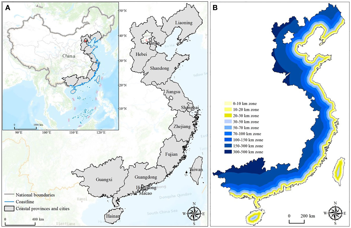
China boasts an extensive coastline with abundant coastal zone resources, spanning across 22 latitude bands (Zhu et al., 2022). The Chinese coastline is geographically diverse, encompassing regions along the East China Sea, South China Sea, Bohai sea, and Yellow Sea, and is home to 14 provinces, municipalities (including special administrative regions), namely Liaoning, Hebei, Tianjin, Shandong, Jiangsu, Shanghai, Zhejiang, Fujian, Guangdong, Hong Kong, Macau, Guangxi, Taiwan, and Hainan (Figure 1A). The coastal economy holds a pivotal position within China’s overall economic landscape. When considering a buffer zone extending 10 kilometers inland and seaward from the coastline, the coastal zone occupies approximately 13% of the national land area. This region hosts 40% of China’s population and contributes 60% of the national Gross Domestic Product (GDP) (Zheng et al., 2020), with an urbanization rate of 64.7% (Meng et al., 2020). This study drew upon the comprehensive national surveys conducted on coastal zones and tidal flat resources in China since the 1980s, along with research examining the impact of land use on carbon storage along China’s coastlines (Zhu et al., 2022). The coastal regions were segmented into distinct zones spanning from 0-10km, 10-20km, 20-30km, 30-50km, 50-70km, 70-100km, 100-150km, 150-300km, to 300-500km (Figure 1B). The investigation aimed to scrutinize the spatiotemporal nuances in land utilization concerning varying distances from the coastline.
2.2 Data sources
The data utilized in this study primarily encompass land use/land cover data, GDP data, population data, slope data, Digital Elevation Model (DEM) data, coastline data, and vector data representing provincial boundaries of coastal provinces, and municipalities. Land use/land cover data were predominantly selected from five temporal intervals: 1985, 1990, 2000, 2010, and 2020, each featuring a spatial resolution of 30 meters. These datasets originate from the China Land Cover Dataset (CLCD), an annual land cover data collection derived from Landsat imagery and generated on the Google Earth Engine platform. The accuracy of CLCD was assessed through visual interpretation of independent samples and third-party validation datasets. Importantly, this study conducted a comprehensive evaluation of CLCD quality by comparing it with state-of-the-art 30-meter thematic products, including Impervious Surface Area (ISA), surface water, and forest cover (Yang and Huang, 2021). GDP and population data were sourced from provincial and municipal statistical yearbooks and official statistical reports. The Digital Elevation Model (DEM) data were acquired from NASA’s Advanced Spaceborne Thermal Emission and Reflection Radiometer Global Digital Elevation Model (ASTER GDEM) with a spatial resolution of 30 meters. Coastal provincial and municipal boundary vector data were obtained from the Resource and Environmental Science and Data Center of the Chinese Academy of Sciences (http://www.resdc.cn). Slope data was calculated from the DEM data using ArcGIS 10.2’s slope tool, generating 30-meter raster dataset.
2.3 Methods
2.3.1 Classification of ecological land
Ecological land refers to areas primarily dedicated to conserving and stabilizing regional ecosystems, capable of directly or indirectly regulating the ecological environment and supporting species survival. These lands possess inherent capabilities for self-regulation, restoration, maintenance, and enhancement, while offering ecosystem services (Long et al., 2015). The delineation of ecological land has long been a focal point of academic discourse, particularly in recent years, as the integration of the “Ecological-Productive-Living” three-space framework with national spatial planning has emerged as a pivotal aspect of China’s Fourteenth Five-Year Plan (Government of China, 2021). Currently, prominent schemes for ecological land classification encompass (1)the ecological element determinism, (2)the generalized ecological function determinism, (3)the dominant function determinism, and (4)the utilization form determinism (Tang et al., 2011; Long et al., 2015; Zhou et al., 2016; Liu et al., 2017; Wang et al., 2017). In this study, we adopted the ecological land classification method proposed by Gao et al. (2021), which is based on the principles of human development while harnessing the primary ecological functions. This classification categorizes land use into ecological land and non-ecological land. Upon reviewing our acquired CLCD data spanning five temporal intervals, we have summarized ecological land primarily into seven types, including Forest, Shrub, Grassland, Water, Snow/Ice, Wetland, and Barren, while non-ecological land predominantly encompasses Cropland and Impervious, as detailed in Table 1 below:
2.3.2 Land use transition matrix
The Land use transition matrix is a matrix-based representation of changes in the area of different land use types. It provides a relatively intuitive way to depict the directional shifts in various land use types over the study period. Its mathematical expression is as Equation 1 (Gao et al., 2021):
where Smn represents the number of conversions occurring between the nth and mth land use types within the study region. The calculation of these conversions was carried out using the ArcGIS 10.2 Raster Calculator tool. A spatial overlay was performed on the land use data spanning the five temporal intervals from 1985 to 2020 within the coastal zone region. This process yielded the transition matrix for various land classes.
2.3.3 Land use development intensity index
In the context of China, the measure of land use development intensity serves as a pivotal indicator assessing the degree of human utilization of land within a specified geographic scope. Internationally, a common practice is to establish a livable threshold at 20%, with a cautionary threshold at 30%. In line with these considerations, the “National Land Plan Outline (2016-2030)” for China stipulates that the land development intensity in China should not exceed 4.62%. In this study, we draw upon the metric proposed by Fan et al. (2012) in the context of main function zoning, which utilizes the proportion of urban and rural construction land area relative to the total regional area as an indicator of development intensity (Guan et al., 2008). Accordingly, we employ the ratio of construction land area to the total area as the development intensity index for the Coastal Zone, denoted as the CCZ. The development intensity index can be calculated in Equation 2.
Where K represents the land use development intensity index for a specific assessment period(%), S denotes the total area of construction land during the assessment period(km2), and A signifies the total area of the research region(km2).
3 Results
3.1 Characteristics of land use changes in coastal zones
3.1.1 Spatiotemporal characteristics of the CCZ
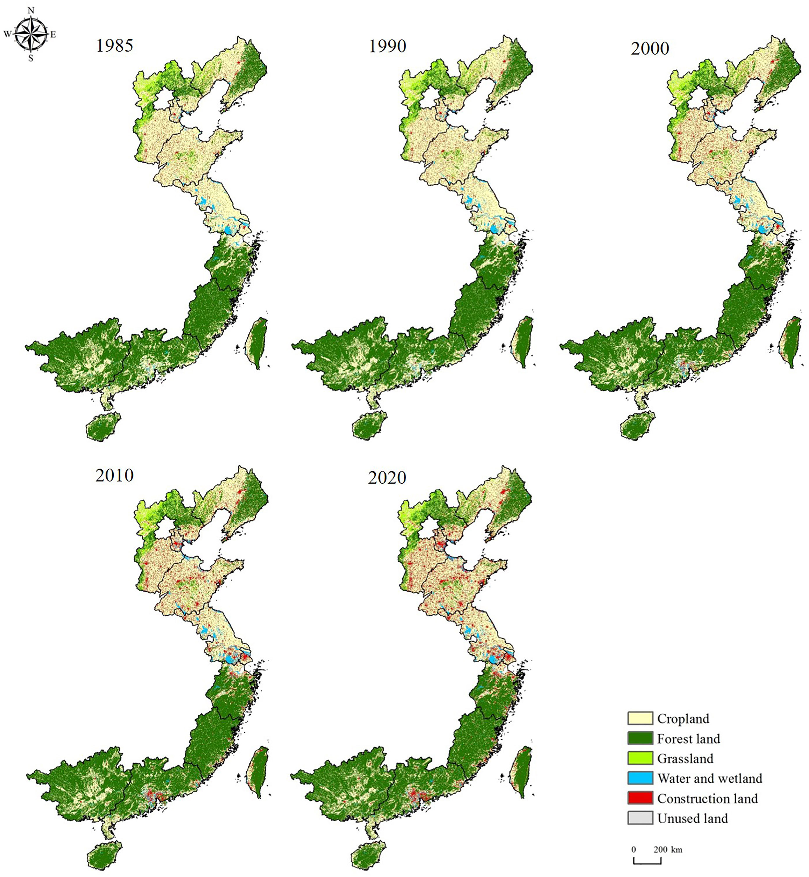
China’s coastal zone was characterized by diverse land use types, with cropland and forest land comprising over 80% of the total area. When examined for spatial distribution from 1985 to 2020, cropland was primarily concentrated in the central and northern regions of the CCZ, notably within the North China Plain. In contrast, forest land predominated in the hilly southern regions of the CCZ. In the northern region of the CCZ, predominant land use consisted of cropland, primarily concentrated in Jiangsu and Shandong, with a significant presence in the southern part of Hebei. Following croplands, forest land prevailed, notably distributed in the northern part of Hebei and the eastern regions of Liaoning. Conversely, in the southern CCZ, forest land took precedence, while cropland occupied a notably smaller proportion, primarily concentrated in Guangxi and Guangdong provinces. Notably, the transformation of construction land was evident, having transitioned from its original scattered distribution to a more aggregated, continuous pattern. This transformation was particularly pronounced within the urban areas of the CCZ, as depicted in Figure 2.
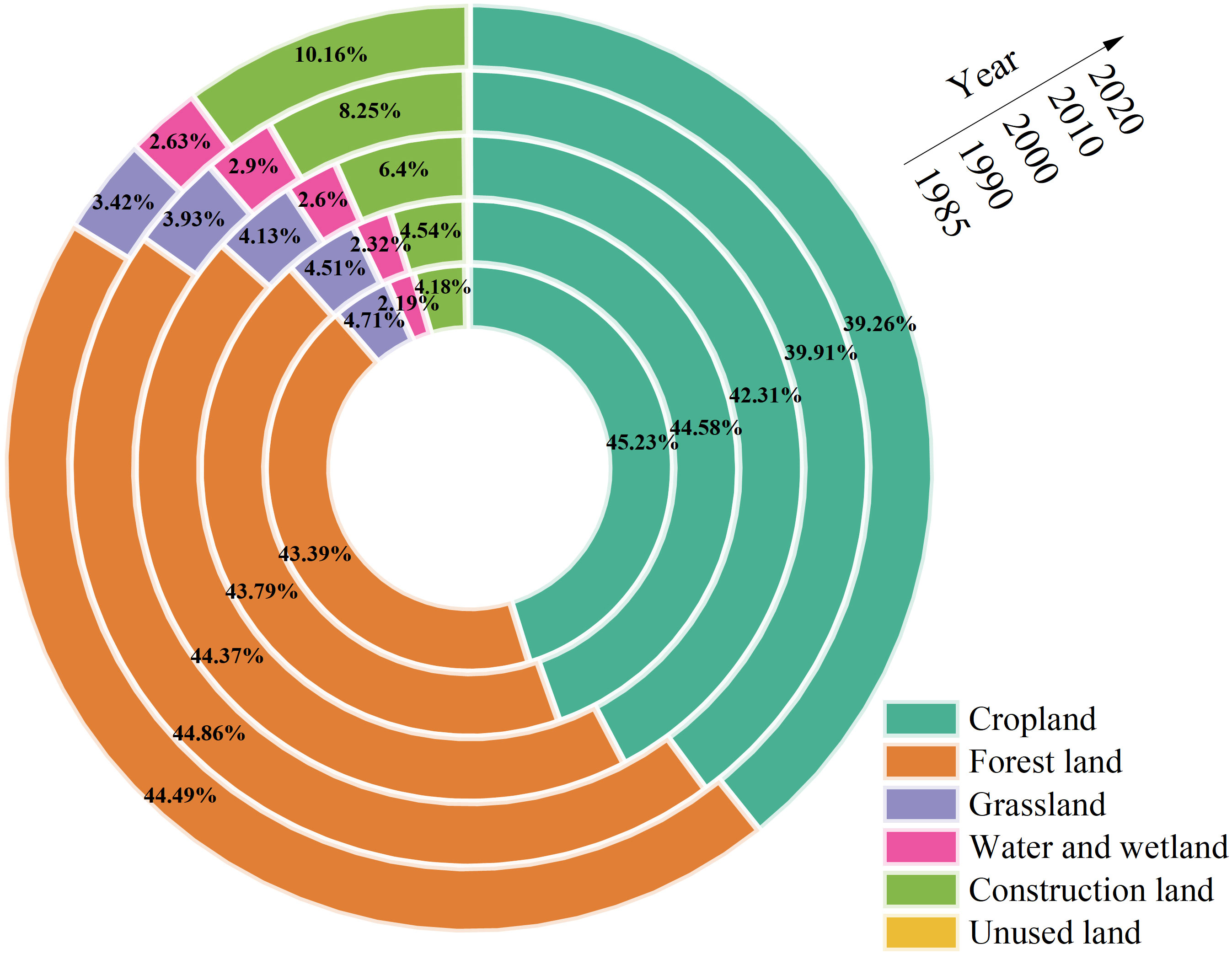
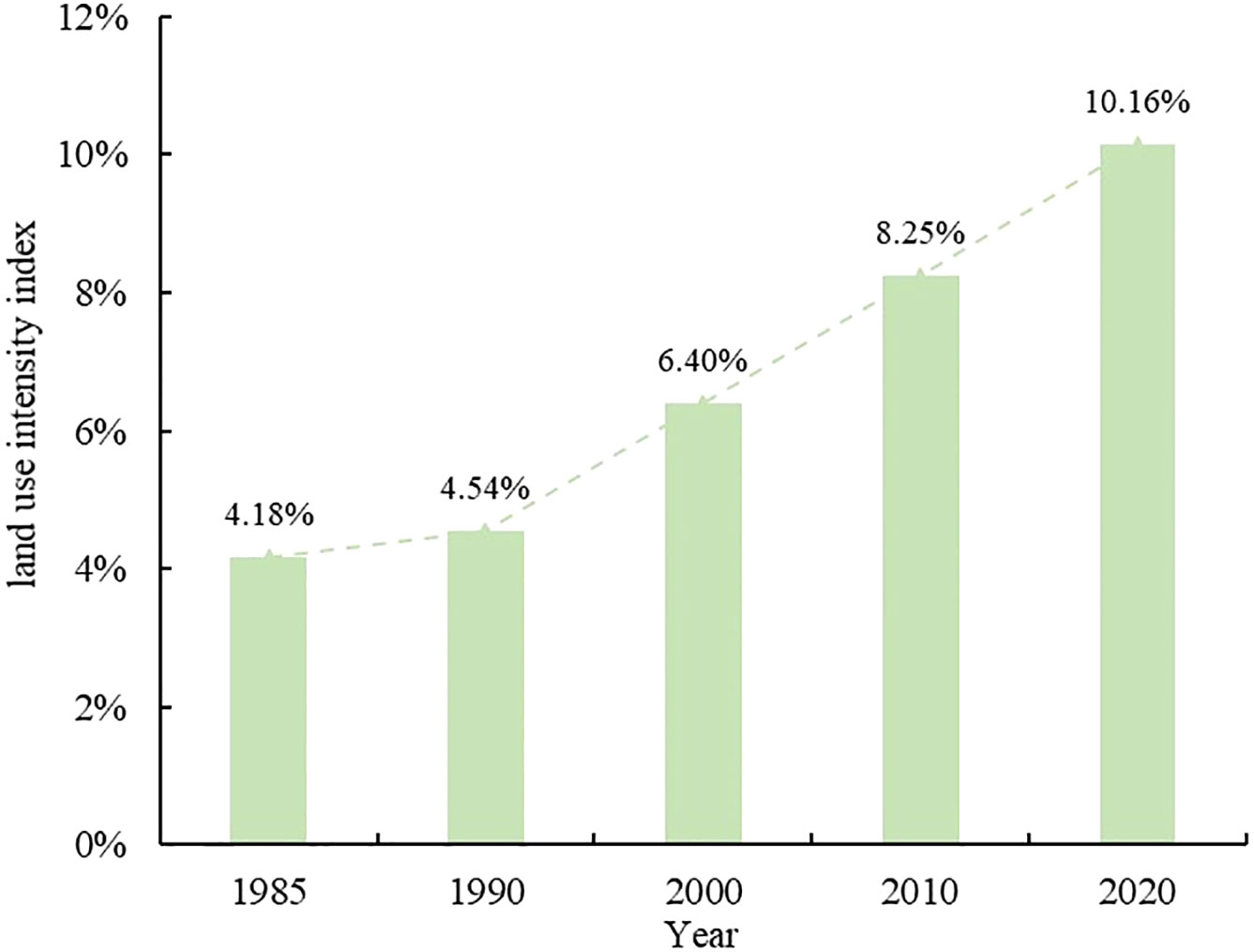
The period from 1985 to 2020 witnessed notable changes in land use within the CCZ region, characterized primarily by a decrease in cropland and a significant increase in construction land. The area of cropland decreased by 5.97%, declining from 45.23% of the total area in 1985 to 39.26% in 2020. Conversely, construction land area increased by 5.98%, rising from 4.18% in 1985 to 10.16% in 2020. Forest land, water and wetlands, exhibited an initial upward trend followed by stabilization. From 1985 to 2015, there was a consistent yearly increase, stabilizing at 44.49% and 2.63%, respectively, by 2020, representing a 1.10% and 0.44% increase. Grassland, on the other hand, showed a continuous decrease over the years, with a total area reduction of 1.29%. Similarly, unused land demonstrated a year-by-year reduction trend, decreasing by a total of 0.26% from 1985 to 2020 (Figure 3).
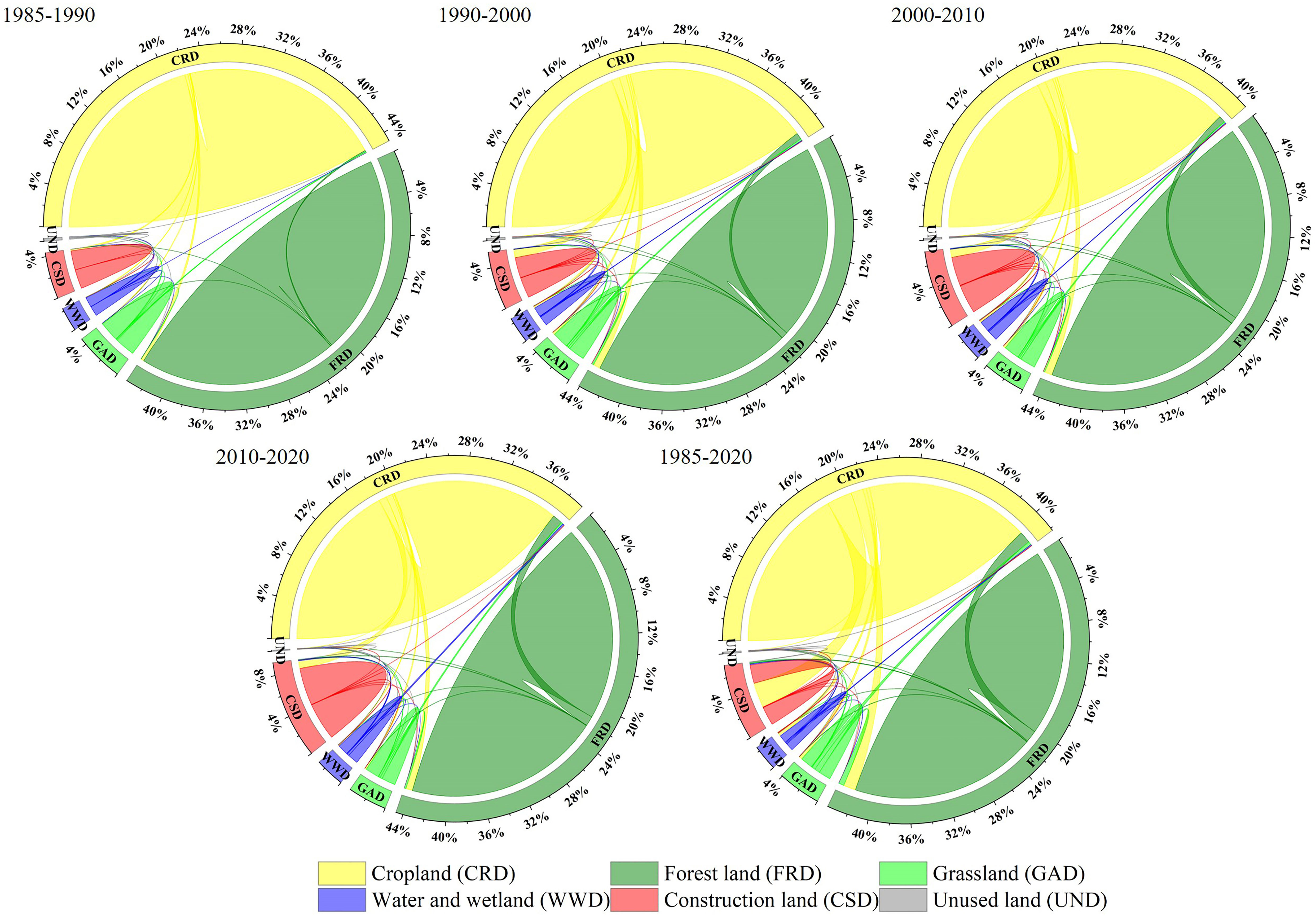
The data presented in Figure 4 reveals that the reduction in cropland within the CCZ region from 1985 to 2020 predominantly transformed into construction land, covering an area of 84,927.21 km². This transformation was widespread, encompassing various regions across the CCZ. Following construction land, forest land accounted for the next significant change, with an area of 4,218.55 km². Forest land alterations were primarily concentrated in the southern parts of the CCZ, followed by the northern and central regions, where the provinces of Shandong, Jiangsu, and Shanghai showed relatively fewer changes. The increase in construction land was primarily driven by the conversion of cropland, followed by forest land. These conversions were widespread and mainly attributable to urban and rural expansion. The increase in forest land predominantly resulted from the transformation of cropland in the southern CCZ region, followed by conversions in the grasslands located at the northern edges of the CCZ. The growth in water and wetlands was primarily attributed to the conversion of cropland, with concentrations in certain areas of Tianjin, Shandong, Jiangsu, and Guangdong, followed by conversions from construction land and unused land. Conversely, the decrease in grassland primarily transformed into forest land, covering an area of 18,133.81 km², with concentrations in the northern part of Hebei and the western part of Liaoning. Cropland conversion also contributed to the decrease, accounting for an area of 11,489.22 km². The reduction in unused land primarily transformed into construction land, followed by water and wetlands. This conversion occurred mainly in the northern parts of Shandong, Tianjin, and the coastal areas of central Jiangsu.
3.1.2 Spatiotemporal characteristics of LUCC in various provinces, and municipalities
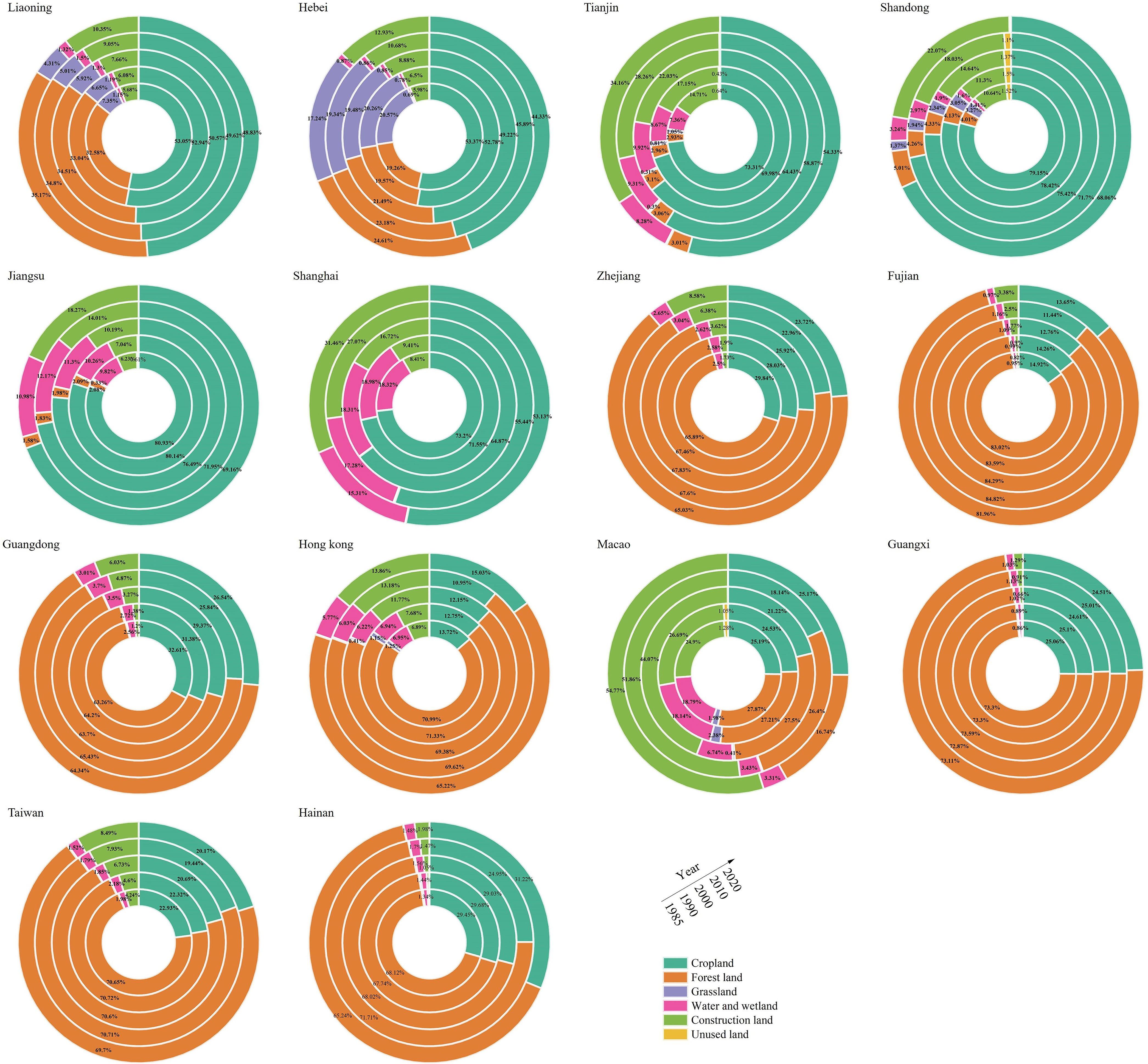
As depicted in Figure 5, notable differences in land use structures were observed among the provinces, and municipalities within the coastal zone in the past. Additionally, substantial spatial heterogeneity existed within each of these administrative divisions. In the past, land use in Liaoning, Hebei, Tianjin, Shandong, Jiangsu, and Shanghai was primarily dominated by cropland. In contrast, Zhejiang, Fujian, Guangdong, Hong Kong, Guangxi, Taiwan, and Hainan predominantly featured forest land as the main land use type. Macau, on the other hand, exhibited construction land as the predominant land use category. Among these regions, Jiangsu had the highest proportion of cropland in the past, followed by Shandong, while Fujian had the lowest proportion. In terms of forest land, Fujian had the largest proportion in the past, followed by Guangxi, with Shanghai having the smallest proportion. Regarding construction land, Macau had the highest proportion in the past, followed by Tianjin, while Guangxi had the lowest proportion.
The dynamic changes in land use among provinces, and municipalities regions within the CCZ from 1985 to 2020 exhibit marked variations. However, a common trend is the notable increase in construction land across these regions. Macau witnessed the most substantial rise in the proportion of construction land, with a remarkable increase of 29.90%, followed by Shanghai and Tianjin, which experienced increases of 23.05% and 19.45%, respectively. In contrast, Guangxi and Hainan had the smallest increments in construction land, registering only 0.9% and 1.49%, respectively. In the CCZ regions, except Hong Kong, Hainan, and Macau, grassland areas have decreased to varying degrees. Shanghai witnessed the most significant decline in grassland area proportion, with a reduction of 20.07%, while Guangxi experienced the smallest decrease. Forest land area diminished in all CCZ provinces, and municipalities regions except for Liaoning, Hebei, Tianjin, Shandong, and Shanghai. Over the past 35 years, the land use patterns in these regions have displayed distinctive trends. Liaoning primarily experienced a substantial reduction in cropland and grassland, coupled with a significant increase in construction land. Hebei’s land use was characterized by a marked decrease in cropland, alongside significant increases in construction land and forest land. Tianjin, Shandong, Jiangsu, Shanghai, Zhejiang, and Guangdong all exhibited significant declines in cropland and substantial increases in construction land. Fujian’s overall land use situation remained relatively stable, but the gradual expansion of construction land accompanied reductions in cropland and forest land. Hong Kong’s land use was primarily characterized by a decrease in forest land and a marked increase in construction land. In Macau, the dominant changes included substantial reductions in forest land and water bodies/wetlands and a significant increase in construction land. Guangxi’s land use changes were relatively minor, with slight decreases in cropland and grassland, accompanied by an increase in construction land.
3.1.3 Spatiotemporal characteristics of land use changes in different distance zones
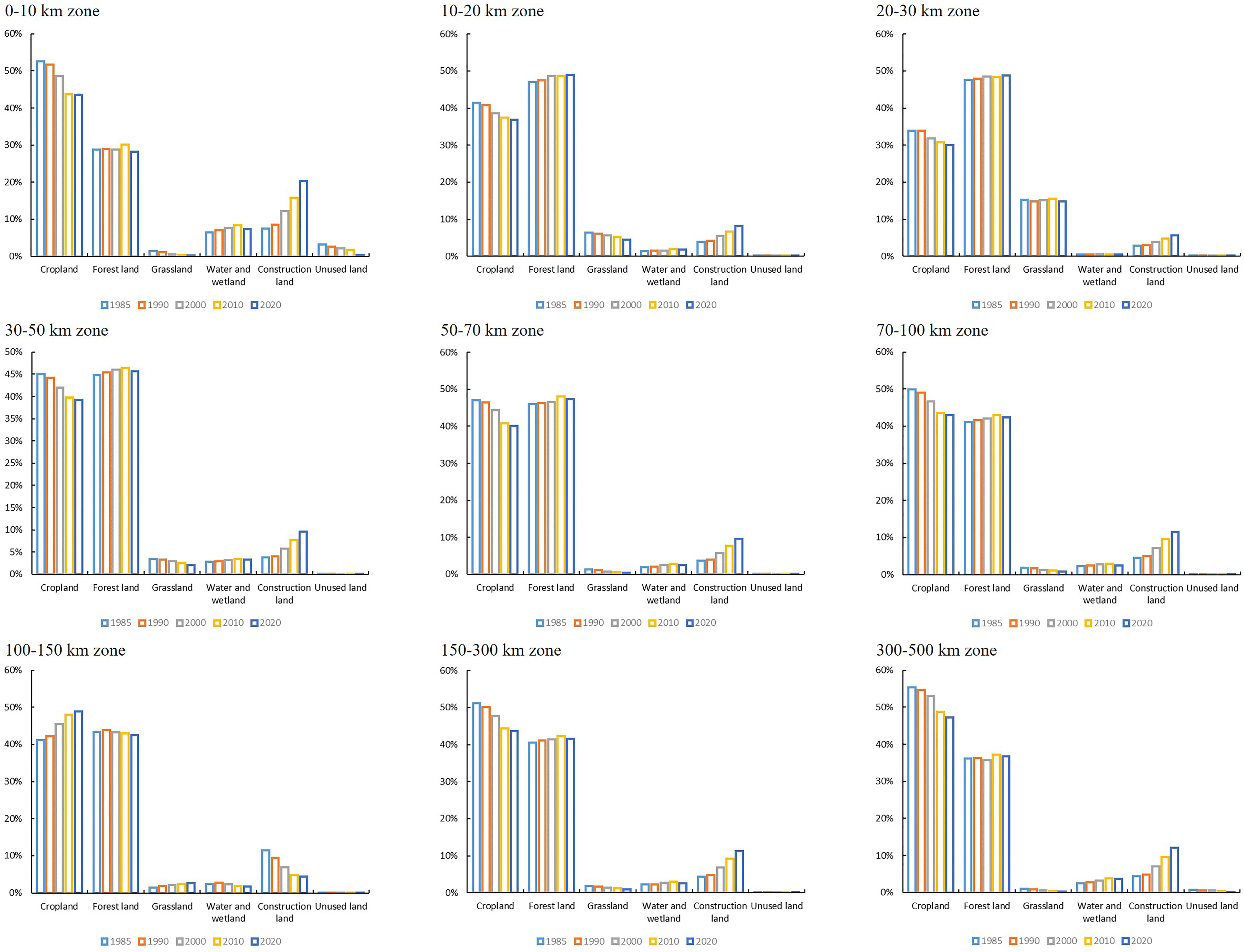
In the comprehensive analysis presented in Figure 6, it becomes evident that cropland and forest land collectively hold sway over the land utilization within various coastal zones, occupying more than 80% of the entire land area. Nevertheless, discernible disparities in land utilization strategies manifest across these distinct zones. Particularly, the category of unused land exhibits relatively minimal presence, with more substantial expanses within the 0-10 km zone, whereas the remaining zones portray notably reduced extents of unused land. Over the course of time, the 10-20 km and 20-50 km zones witnessed a remarkable reduction in unused land, plummeting from 0.02% and 0.03% in 1985 to near insignificance by 2020. Except for the 100-150 km zone, cropland experienced a consistent contraction within all other zones. Despite a general uptrend in construction land, an exception is observed in the 100-150 km zone, where construction land exhibited a diminishing trend.
In the 0-10 km zone, the dominant trends included a reduction in cropland and an increase in construction land. The expansion of construction land had led to a decrease in cropland, resulting in a reduction of 10,500.24 km2. The diminished unused land area had primarily transformed into construction land, followed by water and wetlands. In the 10-20 km zone, forest land had taken precedence and exhibited an increasing trend, while cropland had been on the decline. The increase in forest land had primarily resulted from cropland conversion, covering an area of 3,516.04 km2, while cropland reduction had mainly transformed into construction land, covering an area of 5,768.17 km2. In the 20-30 km zone, cropland reduction had mainly transformed into construction land and forest land. The increase in construction land had primarily originated from cropland and forest land conversion. In the 30-50 km, 50-70 km, and 70-100 km zones, land use changes exhibited similar patterns. With the decrease in cropland, construction land had shown a noticeable increase, while forest land area had experienced fluctuations. In contrast to other zones, the 100-150 km zone witnessed an increase in cropland area and a decrease in construction land area. The expansion of cropland had primarily been attributed to the conversion of forest land and grassland, covering areas of 5,025.29 km2 and 2,221.79 km2, respectively. The decrease in construction land had mainly transformed into water and wetlands, covering an area of 149.16 km2. Within the 150-300 km and 300-500 km zones, both exhibited a reduction in cropland and an increase in construction land. In the 150-300 km zone, cropland reduction had primarily transformed into construction land. In the 300-500 km zone, the decrease in cropland had primarily converted into grassland, followed by construction land and forest land.
3.2 Spatiotemporal characteristics of ecological land use in coastal zone
3.2.1 Spatiotemporal characteristics of the CCZ
From 1985 to 2020, the ecological land in the CCZ region displayed a temporal pattern of initial expansion followed by a subsequent contraction. In 2010, the proportion of ecological land area reached its peak at 51.84%, subsequently regressing to 50.89% in 2020, akin to the levels observed in 1985. When examining the CCZ as a whole, it becomes evident that ecological land is predominantly concentrated in the hilly and mountainous regions of the southern CCZ. Conversely, non-ecological land is primarily concentrated in areas located within the Jianghuai Plain, North China Plain, and Northeast China Plain (Figure 7).
3.2.2 Spatiotemporal characteristics of ecological land in various provinces, and municipalities
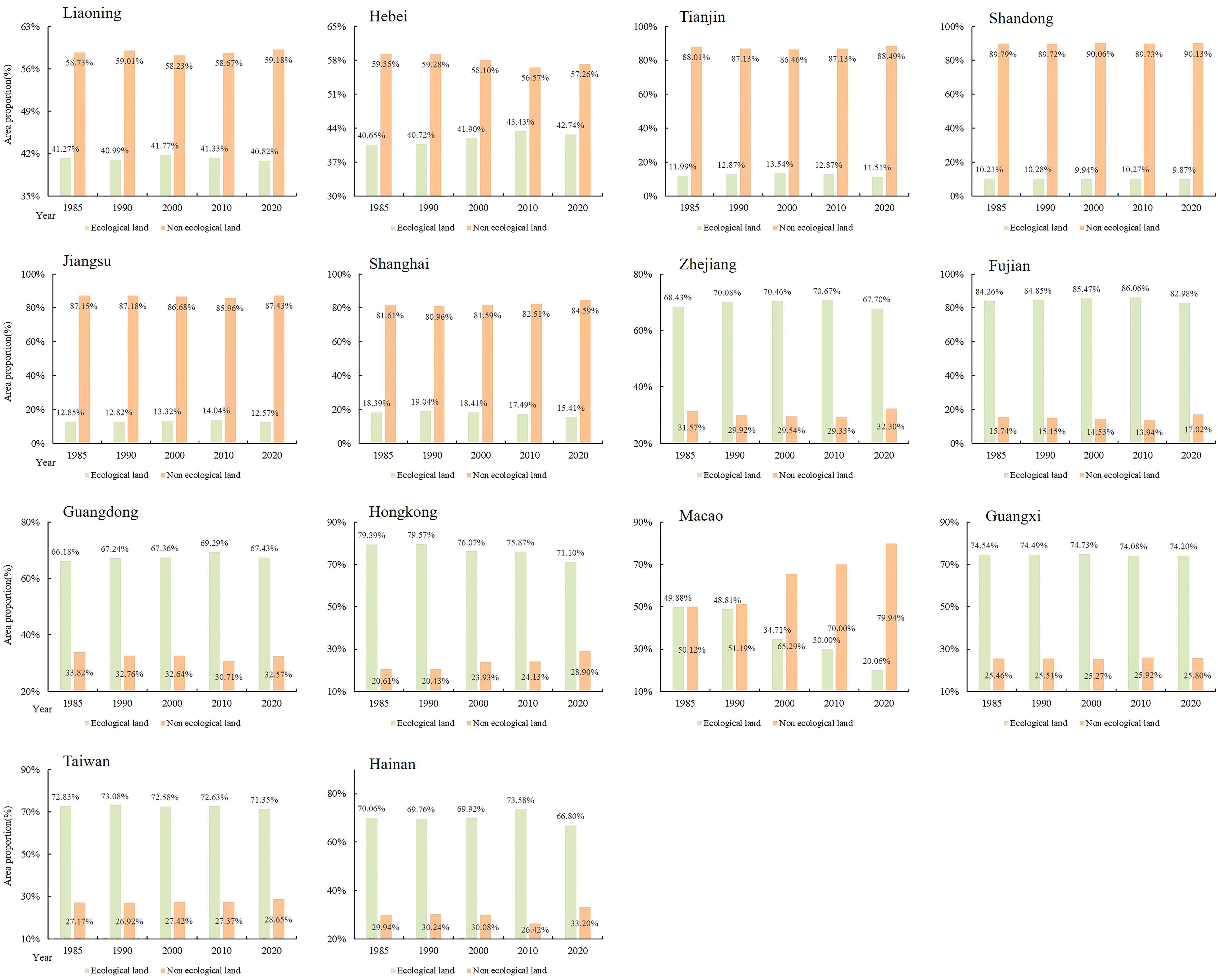
From 1985 to 2020, there was evident spatial heterogeneity in ecological land distribution among the provinces, and municipalities within the CCZ. In regions such as Liaoning, Hebei, Tianjin, Shandong, Shanghai, and Jiangsu, the proportion of ecological land remained relatively low, with non-ecological land predominating. In contrast, in Zhejiang, Fujian, Guangdong, Hong Kong, Guangxi, Taiwan, and Hainan, ecological land took precedence, with Fujian having the highest proportion of ecological land. In the Macau region, ecological land and non-ecological land maintained a state of equilibrium in the early years. However, after 1990, ecological land witnessed a significant reduction, with a decline of 29.82% by 2020, gradually ceding dominance to non-ecological land. Ecological land in Liaoning, Tianjin, Shandong, Jiangsu, and Guangxi remained stable, while Shanghai, Zhejiang, Fujian, Taiwan, and Hainan exhibited fluctuating decreases. Conversely, Hebei and Guangdong displayed fluctuating increases. In Hong Kong, ecological land witnessed a slight increase in 1990 but subsequently exhibited a declining trend, accounting for an 8.29% decrease by 2020 (Figure 8).
3.2.3 Spatiotemporal characteristics of ecological land use changes in different distance zones
Figure 9A revealed insights into the ecological land changes across various distance zones within the CCZ from 1985 to 2020. Notably, there was a consistent trend of ecological land area proportion showing a significant increase followed by fluctuating decreases with increasing distance from the coastline. Within different zones spanning 0-30 km from the coast, there was a marked increase in ecological land area, peaking in the 20-30 km zone. However, in zones spanning 30 km to 500 km from the coast, ecological land area generally decreased, with a minor peak observed in the 100-150 km zone. Figure 9B revealed that from 1985 to 2020, the proportion of ecological land area followed the order: 20-30 km > 10-20 km > 30-50 km > 50-70 km > 100-150 km > 70-100 km > 150-300 km > 300-500 km > 0-10 km. Overall, the ecological land conditions across different distance zones exhibited a fluctuating but stable pattern from the early stages to the end of the study period. However, a notable decrease in ecological land area occurred in the 0-10 km zone from 2010 to 2020.
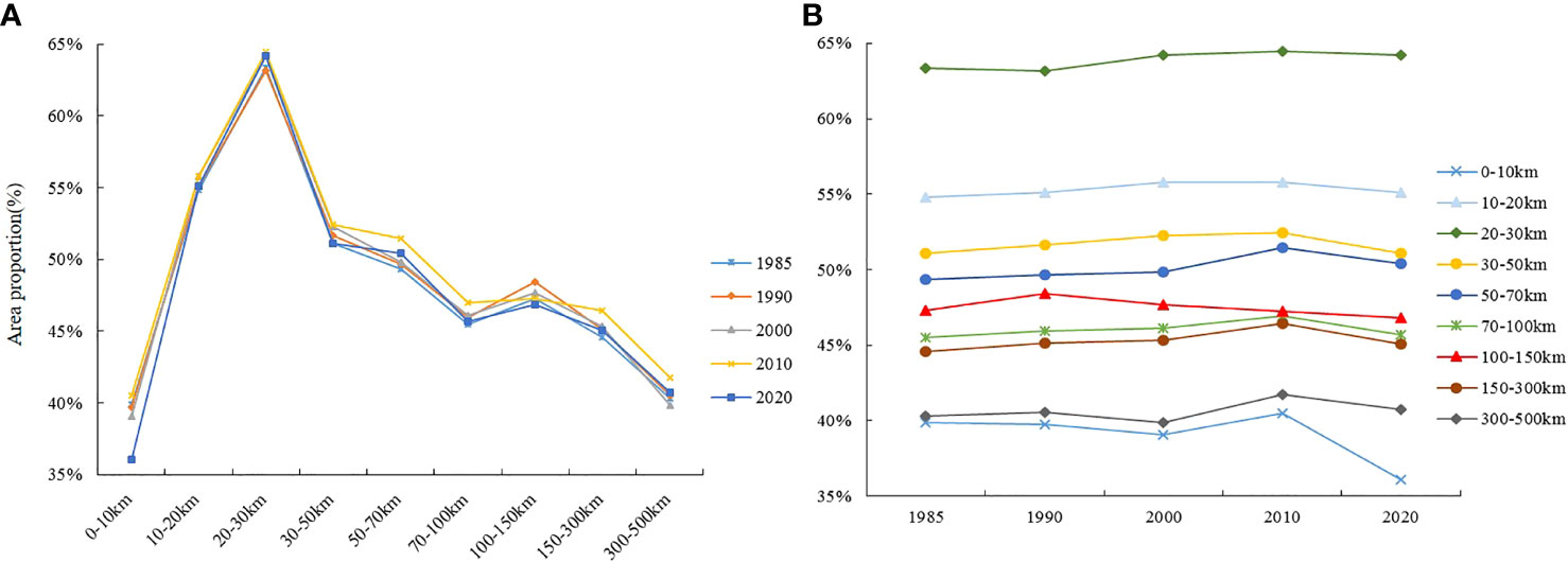
Figure 9 Changes in ecological land use in different distance zones. Changes in different distance zones (A), changes in different time periods (B).
3.3 Characteristics of changes in land use development intensity
3.3.1 Overall characteristics of land use development intensity
From 1985 to 2020, the coastal zone witnessed a progressive increase in land use development intensity, with a notable acceleration post-1990. Driven by China’s rapid economic growth and the swift urbanization process, the intensity of land use development continued to surge, escalating from 4.18% in 1985 to 10.16% in 2020, as depicted in Figure 10. However, it’s imperative to underscore that the intensity of land use development exhibits distinctive spatial heterogeneity. In the earlier phases, development primarily revolved around urban and rural construction areas. As land demand continued to rise, the existing expansion model proved insufficient to meet developmental needs. Consequently, extensive land development and utilization activities extended into regions further away from the urban centers.
3.3.2 Spatiotemporal characteristics of land use development intensity in various provinces and municipalities
The coastal zone experienced an annual increase in land use development intensity across its various provinces, and municipalities. However, the rate of growth exhibited variations, as depicted in Figure 11. By 2020, the order of land use development intensity index from highest to lowest was Macau, Tianjin, Shanghai, Shandong, Jiangsu, Hong Kong, Hebei, Liaoning, Zhejiang, Taiwan, Guangdong, Fujian, Hainan, and Guangxi. Macau witnessed the most significant increase in land use development intensity, with a 29.90% rise in its intensity index. Shanghai followed closely, with a 23.05% increment in its intensity index. Conversely, the land use development intensity indices of Hainan and Guangxi experienced the smallest growth, registering only 1.49% and 0.90%, respectively.
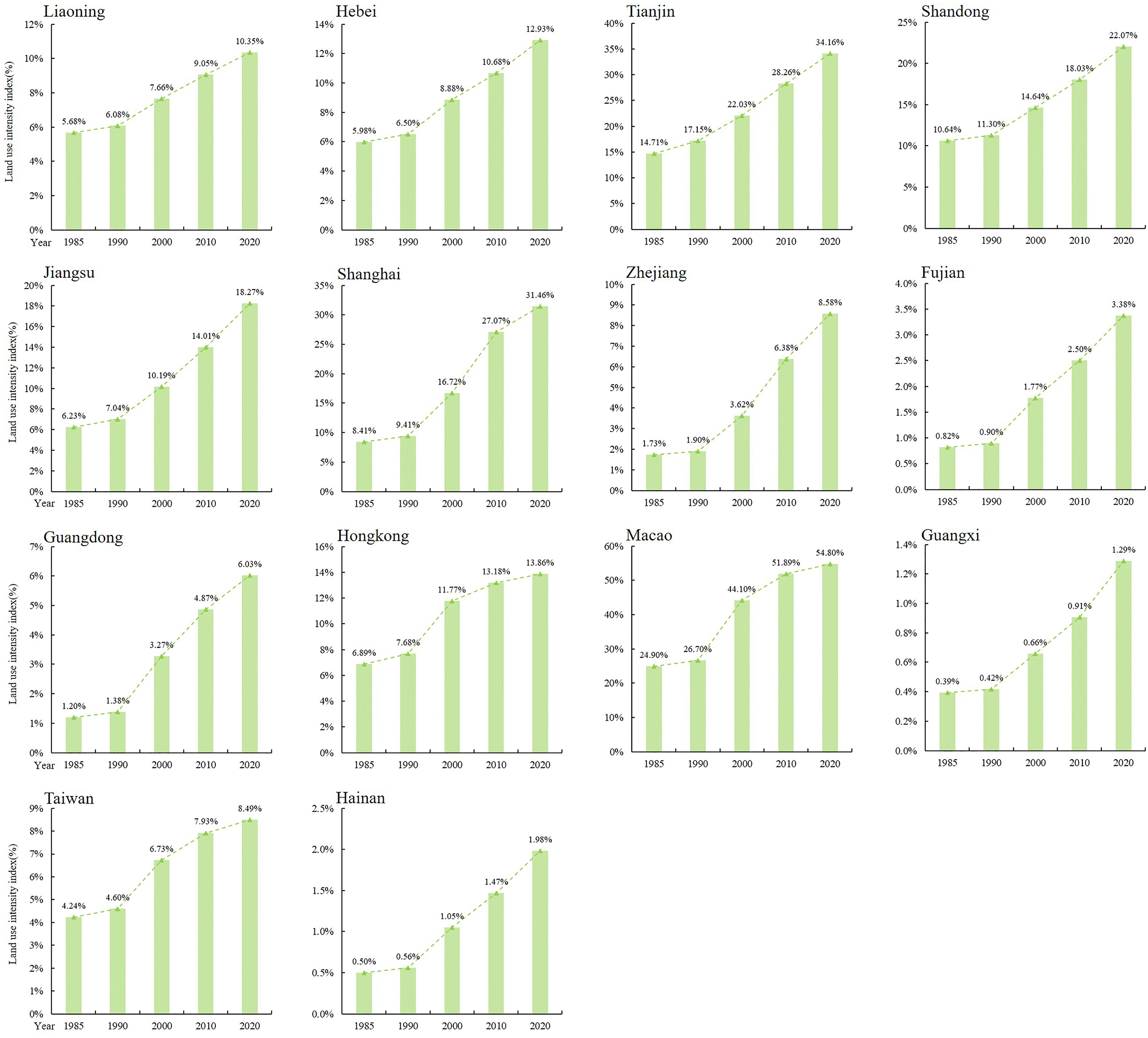
Figure 11 Spatiotemporal characteristics of land use development intensity in various provinces, and municipalities.
3.3.3 Spatiotemporal characteristics of land use development intensity changes in different distance zones
From 1985 to 2020, the coastal zone exhibited noticeable similarities in land use development intensity indices across varying distance zones. Within the 0-100 km zones, a distinct uniformity in land use development intensity became evident. Specifically, the 0-30 km zones experienced a consistent decline in intensity, while the 30-100 km zones demonstrated a fluctuating upward trajectory. Nonetheless, within the 100 km-300 km zones, discernible variations emerged. The intensity indices followed a pattern of decline in 2010 and 2020 after an initial increase, whereas 1985 and 1990 witnessed an initial increase followed by a decrease in intensity. In the 300 km-500 km zone, the intensity indices remained relatively constant across the years, as illustrated in Figure 12A. Throughout the period spanning 1985 to 2020, land use development intensity indices exhibited an ascending tendency across diverse distance zones. This trend became notably pronounced after 1990. Of particular interest is the 0-10 km zone, which not only exhibited the highest land use development intensity indices but also experienced the most significant rate of increase. Subsequently, the 300-500 km zones, the 150-300 km zone, and the 70-100 km zone followed suit. Conversely, the 20-30 km zone displayed the lowest land use development intensity indices, as depicted in Figure 12B.

Figure 12 Changes in land use development intensity in different distance zones. Changes in different distance zones (A), changes in different time periods (B).
4 Discussion
In summary, the changes in land use within coastal zones result from a confluence of natural, economic, and societal factors. From a natural perspective, the topography significantly influences land utilization within coastal areas, as observed by overlaying elevation and land use data. Lower altitude areas were predominantly allocated to agricultural use, gradually replaced by forested regions as elevation increased, aligning with the findings of Hou and Xu (2011). Construction sites were concentrated in lower altitudes, diminishing rapidly as elevations rose. Grasslands primarily thrive in mid to high-altitude regions. Additionally, the amalgamation of slope data indicated that flat terrains are typically more suitable for agricultural and urban development, while steep mountainous areas were more conducive to preservation and ecological restoration. For instance, in the 2020 land use profile along the coast, approximately 66.29% of cropland and 76.11% of construction land were concentrated in slopes below 6°. Conversely, 62.79% of forest land was concentrated in slopes exceeding 15°. However, certain coastal areas are susceptible to storm surges, potentially impacting land use in proximity to the coastline (Kontogianni et al., 2019).
In the realm of socioeconomics, leveraging GDP and population datasets reveals an unprecedented wave of development in coastal regions, spurred by the acceleration of post-1980 reform and opening policies (Ren et al., 2018). Economic growth surged notably, particularly evident in provinces such as Fujian, Guangdong, Jiangsu, and Zhejiang. Comparing the GDP of these provinces in 2020 to 1985, exponential increases of 21652.09%, 19151.03%, 15672.41%, and 14973.42% respectively underscored the burgeoning demand for land and intensified land development endeavors. Markedly amplified population figures, especially in Macau, Guangdong, Shanghai, and Tianjin, registering increases of 129.05%, 122.62%, 101.78%, and 72.34%, respectively since 1985, contributed notably to the mounting need for residential spaces and infrastructure. This burgeoning demand propelled urban expansion and increased land development intensity. Additionally, the burgeoning of industries and tourism, coupled with the exploitation of natural resources such as mining, fishing, and energy, substantially influenced coastal land usage. These activities altered the landscape of land utilization, resulting in significant spatiotemporal variations in the land use patterns of coastal regions and manifest spatial heterogeneities across distinct coastal zones. In recent years, China has taken significant steps to bolster its commitment to safeguarding the national ecological environment and the coastal areas. Stringent measures have been put in place to regulate coastal reclamation, including the implementation of comprehensive control strategies. A notable development in this regard is the establishment of a core natural reserve system, predominantly centered around national parks. This conservation-oriented approach is further reinforced by the enforcement of the “People’s Republic of China Wetland Protection Law,” which serves to intensify the oversight and management of coastal natural resources. Concurrently, China has undertaken ambitious ecological protection and restoration projects. These initiatives encompass 36 “Blue Bay” remediation projects, 15 coastal protection and restoration efforts, and specialized programs dedicated to the preservation and rehabilitation of mangrove ecosystems. The cumulative outcome of these endeavors has been the restoration of approximately 1200 km2 of coastline and 23,000 ha of coastal wetlands. Importantly, these strategic actions have effectively arrested the degradation of coastal wetland ecosystems and yielded conspicuous improvements in the overall ecological quality. The concerted focus on ecological preservation and restoration has yielded a twofold benefit (Duan et al., 2023). Not only has it contributed to the amelioration of the land use development intensity trends within the coastal zones, but it has also resulted in tangible enhancements in the overall ecological quality of these areas. However, as indicated by the findings of this study, discernible disparities exist in land use development intensity across different zones, notably remaining at elevated levels, particularly within the 0-10 km zone from the coastline. Future governmental strategies necessitate a controlled approach towards the exploitation intensity of coastal land resources, alleviating fiscal dependence on land, and further enhancing land use efficiency. This calls for reinforced protection measures for arable land and coastal beach resources, coupled with intensified ecological monitoring and restoration in areas witnessing high-intensity land use changes. Strengthened governmental management for unused land, accompanied by tiered development or on-site construction of temporary green spaces on long-idle and unused land parcels, should be implemented. Strict adherence to policies safeguarding arable land and coastal wetlands is essential, curtailing the rate and intensity of land use changes near permanent agricultural land, eco-redline zones, and nature reserves, especially in crucial estuarine and wetland distribution areas, by implementing policies for retiring land back to the sea or restoring shorelines. For areas newly converted into construction land, rigorous terrestrial and marine ecological assessments must be conducted to identify eutrophication, heavy metal pollution, wetland degradation, and other ecological concerns, facilitating prompt remediation of damaged ecosystems and contaminated environments.
5 Conclusions
Utilizing the CLCD dataset, we analyzed the dynamic alterations in land use along China’s coastal zones from 1985 to 2020. The results showed that the CCZ was primarily characterized by predominant cropland and forest land, showcasing a notable shift marked by decreased cropland and a conspicuous surge in construction land. The decline in cropland was chiefly redirected towards construction land and forest land, while the increase in construction land largely arose from the conversion of cropland and forest land. While the ecological land in the CCZ region exhibited an initial increase followed by subsequent reduction before stabilizing, the land use development intensity continued to increase steadily, increasing by 10.16%. Notably, distinct variations in both spatial and temporal land use structures were evident among provinces and municipalities. Except for Macau, where construction land predominated, the rest were primarily composed of cropland or forest land. The trends indicated a marked increase in both construction land and land use development intensity, with Macau experiencing the highest increase, while Guangxi showed the least growth. However, discernible disparities in the fluctuations of ecological land were notable, with Hebei and Guangdong portraying oscillating growth while others trended towards stability or reduction. Although an overall inclination towards increased construction land was observed, a decline in construction land was witnessed within the 100-150km zone. Moreover, the expanse of ecological land showed an initial increase followed by fluctuating declines relative to increased distance from the coastline. The land use development intensity notably decreased initially as the distance from the coastline augmented, followed by a modest rise before stabilizing. However, within the 0-10km zone, the land use development intensity stood highest.
Data availability statement
The original contributions presented in the study are included in the article/supplementary material. Further inquiries can be directed to the corresponding author.
Author contributions
XZ: Conceptualization, Data curation, Formal analysis, Investigation, Methodology, Software, Supervision, Validation, Visualization, Writing – original draft, Writing – review & editing. JN: Conceptualization, Data curation, Methodology, Visualization, Writing – review & editing.
Funding
The author(s) declare financial support was received for the research, authorship, and/or publication of this article. This research was funded by the National Natural Science Foundation of China, Grant No.42171368.
Conflict of interest
The authors declare that the research was conducted in the absence of any commercial or financial relationships that could be construed as a potential conflict of interest.
The reviewer, YZ, declared a shared parent affiliation with the authors to the handling editor at the time of review.
Publisher’s note
All claims expressed in this article are solely those of the authors and do not necessarily represent those of their affiliated organizations, or those of the publisher, the editors and the reviewers. Any product that may be evaluated in this article, or claim that may be made by its manufacturer, is not guaranteed or endorsed by the publisher.
References
Abd El-sadek E., Elbeih S., Negm A. (2022). Coastal and landuse changes of Burullus Lake, Egypt: A comparison using Landsat and Sentinel-2 satellite images. Egyptian J. Remote Sens. Space Sci. 25 (3), 815–829. doi: 10.1016/j.ejrs.2022.07.006
Adade R., Aibinu A. M., Ekumah B., Asaana J. (2021). Unmanned Aerial Vehicle (UAV) applications in coastal zone management-a review. Environ. Monit. Assess. 193 (3), 153. doi: 10.1007/s10661-021-08949-8
Ajikah L. B. B., Adekanmbi O. H. H., Oyebanji O. O. O., Agboola O. O., Akomaye F. A. A., Adeonipekun P. A. A., et al. (2023). Floral composition and diversity of the lagos coastal environment, South-Western, Nigeria. Afr. J. Ecol. 61 (1), 37–47. doi: 10.1111/aje.13080
Di X., Hou X., Wu L. (2014). Land use classification system for China's coastal zone based on remote sensing. Resour. Sci. 36 (3), 463–472.
Du P., Hou X., Xu H. (2022). Dynamic expansion of urban land in China's coastal zone since 2000. Remote Sens. 14 (4), 916. doi: 10.3390/rs14040916
Duan K., Liu Z., Liang S., Li Y., Lu D. (2023). Marine ecological protection and restoration:International agendas and China action. Bull. Chin. Acad. Sci. 38 (2), 277–287. doi: 10.16418/j.issn.1000-3045.20211215005
Duarte C. M., Agusti S., Barbier E., Britten G. L., Carlos Castilla J., Gattuso J.-P., et al. (2020). Rebuilding marine life. Nature 580 (7801), 39–51. doi: 10.16418/j.issn.1000-3045.20211215005
Ellis E. C., Kaplan J. O., Fuller D. Q., Vavrus S., Goldewijk K. K., Verburg P. H. (2013). Used planet: A global history. Proc. Natl. Acad. Sci. U. States America 110 (20), 7978–7985. doi: 10.1073/pnas.1217241110
Fan J., Sun W., Zhou K., Chen D. (2012). Major Function Oriented Zone: New method of spatial regulation for reshaping regional development pattern in China. Chin. Geogr. Sci. 22 (2), 196–209. doi: 10.1007/s11769-012-0528-y
Gao J., Liu X., Wang C., Wang Y., Fu Z., Hou P., et al. (2021). Evaluating changes in ecological land and effect of protecting important ecological spaces in China. Acta Geographica Sin. 76 (7), 1708–1721. doi: 10.1007/s11442-021-1896-y
Gao Y., Liu J., Li W., Lei Y., Zou Y., Cui L. (2022). Characteristics of human activity in China’s coastal zone based on multi-source spatio-temporal data. ISPRS Ann. Photogramm. Remote Sens. Spatial Inf. Sci. 3, 397–404. doi: 10.5194/isprs-annals-V-3-2022-397-2022
Government of China (2021) The 14th Five-Year Plan and the 2035 Long-Range Objectives Outline for the National Economic and Social Development of the People's Republic of China. Available at: https://www.gov.cn/xinwen/2021-03/13/content_5592681.htm.
Guan D., Gao W., Watari K., Fukahori H. (2008). Land use change of Kitakyushu based on landscape ecology and Markov model. J. Geogr. Sci. 18 (4), 455–468. doi: 10.1007/s11442-008-0455-0
Guo Z., Hu Y., Bai Y., Yang L., Wang J. (2022). How to control coastal zone through spatial planning? Taking the construction of the spatial monitoring index system of the coastal zone in China as an example. Front. Environ. Sci. 10, 876414. doi: 10.3389/fenvs.2022.876414
Han D., Currell M. J. (2022). Review of drivers and threats to coastal groundwater quality in China. Sci. Total Environ. 806, 150913. doi: 10.1016/j.scitotenv.2021.150913
Hou X., Di X., Hou W., Wu L., Liu J., Wang J., et al. (2018). Accuracy evaluation of land use mapping using remote sensing techniques in coastal zone of China. J. Geo Information Sci. 20 (10), 1478–1488. doi: 10.12082/dqxxkx.2018.180184
Hou X., Xu X. (2011). Spatial patterns of land use in coastal zones of China in the early 21st century. Geogr. Res. 30 (8), 1370–1379. doi: 10.11821/yj2011080003
Huang J., Zhang G., Zhang Y., Guan X., Wei Y., Guo R. (2020). Global desertification vulnerability to climate change and human activities. Land Degrad. Dev. 31 (11), 1380–1391. doi: 10.1002/ldr.3556
Jiang Z., Wang B., Jiang L., Chen Y., Liu J., Ren Y., et al. (2020). Zonal division of natural resources in the coastal zone of China. Resour. Sci. 42 (10), 1900–1910. doi: 10.18402/resci.2020.10.07
Jin X., Jin Y., Mao X. (2019). Ecological risk assessment of cities on the Tibetan Plateau based on land use/land cover changes - Case study of Delingha City. Ecol. Indic. 101, 185–191. doi: 10.1016/j.ecolind.2018.12.050
Kontogianni A., Damigos D., Kyrtzoglou T., Tourkolias C., Skourtos M. (2019). Development of a composite climate change vulnerability index for small craft harbours. Environ. Hazards Human Policy Dimensions 18 (2), 173–190. doi: 10.1080/17477891.2018.1512469
Li H., Mao D., Wang Z., Huang X., Li L., Jia M. (2022). Invasion of Spartina alternilora in the coastal zone of mainland China: Control achievements from 2015 to 2020 towards the Sustainable Development Goals. J. Environ. Manage. 323, 116242. doi: 10.1016/j.jenvman.2022.116242
Li X., Yu R., Geng H., Li Y. (2021). Increasing dominance of dinoflagellate red tides in the coastal waters of Yellow Sea, China. Mar. pollut. Bull. 168, 112439. doi: 10.1016/j.marpolbul.2021.112439
Liu Y., Hou X., Li X., Song B., Wang C. (2020). Assessing and predicting changes in ecosystem service values based on land use/cover change in the Bohai Rim coastal zone. Ecol. Indic. 117, 106004. doi: 10.1016/j.ecolind.2019.106004
Liu J., Liu Y., Li Y. (2017). Classification evaluation and spatial-temporal analysis of "production-living-ecological" spaces in China. Acta Geographica Sin. 72 (7), 1290–1304. doi: 10.11821/dlxb201707013
Liu Y., Xiao X., Li J., Wang X., Chen B., Sun C., et al. (2023). Tracking changes in coastal land cover in the Yellow Sea, East Asia, using Sentinel-1 and Sentinel-2 time-series images and Google Earth Engine. Isprs J. Photogramm. Remote Sens. 196, 429–444. doi: 10.1016/j.isprsjprs.2022.12.029
Liu C., Yang M., Hou Y., Xue X. (2021). Ecosystem service multifunctionality assessment and coupling coordination analysis with land use and land cover change in China's coastal zones. Sci. Total Environ. 797, 149033. doi: 10.1016/j.scitotenv.2021.149033
Long H., Liu Y., Li T., Wang J., Liu A. (2015). A primary study on ecological land use classification. Ecol. Environ. Sci. 24 (1), 1–7. doi: 10.16258/j.cnki.1674-5906.2015.01.001
Meng Z., Liu M., Gao C., Zhang Y., She Q., Long L., et al. (2020). Greening and browning of the coastal areas in mainland China: Spatial heterogeneity, seasonal variation and its influential factors. Ecol. Indic. 110, 105888. doi: 10.1016/j.ecolind.2019.105888
Mouw C. B., Greb S., Aurin D., DiGiacomo P. M., Lee Z., Twardowski M., et al. (2015). Aquatic color radiometry remote sensing of coastal and inland waters: Challenges and recommendations for future satellite missions. Remote Sens. Environ. 160, 15–30. doi: 10.1016/j.rse.2015.02.001
Pena S. B., Abreu M. M., Magalhaes M. R. (2021). Rethinking coastal cliff protection zones for landscape planning. What limits are enough? Appl. Geogr. 127, 102387. doi: 10.1016/j.apgeog.2021.102387
Pinto R., Martins F. C. (2013). The Portuguese National Strategy for Integrated Coastal Zone Management as a spatial planning instrument to climate change adaptation in the Minho River Estuary (Portugal NW-Coastal Zone). Environ. Sci. Policy 33, 76–96. doi: 10.1016/j.envsci.2013.04.005
Qing Y., Nie X., Wang H., Wei Z., Pang H. (2022). Assessment of the effects of integrated coastal zone management based on synthetic control method. Front. Mar. Sci. 9, 1014246. doi: 10.3389/fmars.2022.1014246
Ren W., Ji J., Chen L., Zhang Y. (2018). Evaluation of China's marine economic efficiency under environmental constraints-an empirical analysis of China's eleven coastal regions. J. Clean. Prod. 184, 806–814. doi: 10.1016/j.jclepro.2018.02.300
Ryabinin V., Barbiere J., Haugan P., Kullenberg G., Smith N., McLean C., et al. (2019). The UN decade of ocean science for sustainable development. Front. Mar. Sci. 6, 470. doi: 10.3389/fmars.2019.00470
Song X., Hansen M. C., Stehman S. V., Potapov P. V., Tyukavina A., Vermote E. F., et al. (2018). Global land change from 1982 to 2016. Nature 560 (7720), 639–643. doi: 10.1038/s41586-018-0411-9
Tang X., Chen B., Lu Q., Yang K., Song W. (2011). Primary exploration on the ecological land use classification in Beijing. Acta Ecol. Sin. 31 (14), 3902–3909. doi: 10.1016/S1671-2927(11)60313-1
Tzepkenlis A., Grammalidis N., Kontopoulos C., Charalampopoulou V., Kitsiou D., Pataki Z., et al. (2022). An integrated monitoring system for coastal and Riparian areas based on remote sensing and machine learning. J. Mar. Sci. Eng. 10 (9), 1322. doi: 10.3390/jmse10091322
Waltham N. J., Elliott M., Lee S. Y., Lovelock C., Duarte C. M., Buelow C., et al. (2020). UN decade on ecosystem restoration 2021-2030-what chance for success in restoring coastal ecosystems? Front. Mar. Sci. 7, 71. doi: 10.3389/fmars.2020.00071
Wang Y., Liao J., Ye Y., Fan J. (2022). Long-term human expansion and the environmental impacts on the coastal zone of China. Front. Mar. Sci. 9, 1033466. doi: 10.3389/fmars.2022.1033466
Wang J., Wang W., Qi Y., He T., Wu R., Chen Y. (2017). Classification system and spatio-temporal distribution of ecological land in China in the period of 1996-2012. Geogr. Res. 36 (3), 453–470. doi: 10.11821/dlyj201703005
Wang C., Zhou Y., Zhang H., Li Y., Liu H., Dong B. (2022). Study on the rare waterbird habitat networks of a new UNESCO World Natural Heritage site based on scenario simulation. Sci. Total Environ. 843, 157058. doi: 10.1016/j.scitotenv.2022.157058
Wu W., Zhi C., Gao Y., Chen C., Chen Z., Su H., et al. (2022). Increasing fragmentation and squeezing of coastal wetlands: Status, drivers, and sustainable protection from the perspective of remote sensing. Sci. Total Environ. 811, 152339. doi: 10.1016/j.scitotenv.2021.152339
Xin X., Zhang T., He F., Zhang W., Chen K. (2023). Assessing and simulating changes in ecosystem service value based on land use/cover change in coastal cities: A case study of Shanghai, China. Ocean Coast. Manage. 239, 106591. doi: 10.1016/j.ocecoaman.2023.106591
Yang J., Huang X. (2021). The 30 m annual land cover dataset and its dynamics in China from 1990 to 2019. Earth Syst. Sci. Data 13 (8), 3907–3925. doi: 10.5194/essd-13-3907-2021
Ye Y., Wang Y., Liao J., Chen J., Zou Y., Liu Y., et al. (2022). Spatiotemporal pattern analysis of land use functions in contiguous coastal cities based on long-term time series remote sensing data: A case study of Bohai Sea Region, China. Remote Sens. 14 (15), 3518. doi: 10.3390/rs14153518
Zheng Z., Wu Z., Chen Y., Yang Z., Marinello F. (2020). Exploration of eco-environment and urbanization changes in coastal zones: A case study in China over the past 20 years. Ecol. Indic. 119, 106847. doi: 10.1016/j.ecolind.2020.106847
Zhou Z., Meng J., Qi Y., Peng F. (2016). Importance of ecological lands and their pattern optimization in China: A review. Chin. J. Ecol. 35 (1), 218–225. doi: 10.132927/j.1000-4890.201601.030
Zhu L., Song R., Sun S., Li Y., Hu K. (2022). Land use/land cover change and its impact on ecosystem carbon storage in coastal areas of China from 1980 to 2050. Ecol. Indic. 142, 109178. doi: 10.1016/j.ecolind.2022.109178
Keywords: land use, spatiotemporal characteristics, ecological land use, land use development intensity, coastal zones, China
Citation: Zhang X and Ning J (2024) Land use change in coastal zones of China from 1985 to 2020. Front. Mar. Sci. 11:1323032. doi: 10.3389/fmars.2024.1323032
Received: 17 October 2023; Accepted: 19 January 2024;
Published: 02 February 2024.
Edited by:
James Scott Maki, Marquette University, United StatesReviewed by:
Yunqiao Zhou, Chinese Academy of Sciences (CAS), ChinaJialin Li, Ningbo University, China
Copyright © 2024 Zhang and Ning. This is an open-access article distributed under the terms of the Creative Commons Attribution License (CC BY). The use, distribution or reproduction in other forums is permitted, provided the original author(s) and the copyright owner(s) are credited and that the original publication in this journal is cited, in accordance with accepted academic practice. No use, distribution or reproduction is permitted which does not comply with these terms.
*Correspondence: Jia Ning, bmluZ2pAaWdzbnJyLmFjLmNu
 Xiongyi Zhang
 Jia Ning1*