 Carmen Ferrà
 Giuseppe Scarcella
95% of researchers rate our articles as excellent or good
Learn more about the work of our research integrity team to safeguard the quality of each article we publish.
Find out more
ORIGINAL RESEARCH article
Front. Mar. Sci. , 25 September 2023
Sec. Marine Affairs and Policy
Volume 10 - 2023 | https://doi.org/10.3389/fmars.2023.1213211
This article is part of the Research Topic Shipping Pressures and Impacts on the Marine Environment View all 8 articles
The marine environment is highly stressed by anthropogenic pressures, among which fisheries, and in particular bottom trawling, are one of the main sources of impact. Area-based conservation measures can help conserve and restore ecosystems and population structures and therefore constitute a key tool to the achievement of the 14th Sustainable Development Goal, preservation of the ocean. The purpose of this paper is to provide an assessment of the compliance of area-based conservation measures. The Adriatic Sea has been selected as a case study area, as one of the most intensively trawled areas in the world where different countries share its resources and consequently different management strategies are put in place. We present a review of the marine managed areas established in the Adriatic Sea in 2019, providing information on their characteristics, temporal variabilities, and scopes. Through the processing of Automatic Identification System (AIS) data, the monthly bottom fishing activity performed within each area was inferred and the intensity was assessed. Thus, the effectiveness of trawling bans was evaluated. We demonstrated that full respect of the prohibition was effective in 73% of the areas, while trawling activity was recorded with different intensities in 149 out of 549 managed areas.
It is well known that the ocean, the largest ecosystem on Earth covering more than 70% of its surface, is continuously being damaged as a result of human activities, especially in coastal areas. Anthropogenic activities have huge impacts on ecosystem services, which are key elements for human well-being. In order to reverse the negative trend of natural resource loss, particularly of biodiversity and functions and services related to ecosystems (Claudet et al., 2008), over the last decades different policies and initiatives have been established to protect environments and their biodiversity.
At a global scale, in 1992, the Convention on Biological Diversity (CBD) identified the objectives of conserving biological diversity, sustainably using its components, and distributing the benefits derived from the use of genetic resources equitably and fairly. Later in 2000, the United Nations (UN) included the achievement of environmental sustainability by 2015 as one of the Millennium Development Goals (MDGs). Both international legal instruments were correlated, as the CBD Strategic Plan for Biodiversity 2011–2020 established clear goals and objectives that had to be accomplished to enable the achievement of the MDGs. Although some improvements were achieved with the adoption of the MDGs, in 2015 the UN launched Agenda 2030 with 17 Sustainable Development Goals (SDGs) defined in order to go further in promoting prosperity while protecting the planet worldwide. The adoption of SDGs by all countries represented a step forward to accomplish the conservation of biological diversity with respect to the previous MDGs, which applied only to developing countries.
At the European level, in 1992 the Habitats Directive (HD) defined the Natura 2000 network, which protects a set of key breeding and resting sites for rare and threatened species and particular natural habitat types. Focusing on the marine environment, the HD required the designation of Natura 2000 sites to protect 16 species and nine marine habitat types. In order to further protect the marine environment, in 2008, the European Union (EU) adopted the Marine Strategy Framework Directive (MSFD), the main objective of which was to achieve a Good Environmental Status (GES) of EU marine waters by 2020.
Despite the development and application of multiple regulations and conservation strategies, current anthropogenic stressors continue to impact and modify ecosystems globally (Aronson et al., 2011; Adyasari et al., 2021). Fisheries are one of the main sources of ecological disturbance in the marine environment (White and Pickett, 1985; Halpern et al., 2015), which has increased considerably over the last century as technological advancements have allowed the increase of effectiveness and the expansion to areas beyond the continental shelf. In fact, the cumulative effects of fishing, together with other relevant pressures (e.g., climate change, invasion of alien species, and marine pollution), have led the UN to include the preservation of the oceans as the 14th SDG, namely, “conserve and sustainably use the oceans, seas and marine resources for sustainable development.” Although the impact of fisheries on marine stocks has been recognized since the fifties (Garcia & Newton, 1994), their (often devastating) impact on the ecosystems did not become a global concern until the mid-1990s (Watling & Norse, 1998). In fact, the Common Fisheries Policy (CFP) of the EU, which initially focused exclusively on the control of exploitation rates (Casey et al., 2016), states that an ecosystem-based approach to fishery management (EAFM) is needed as fisheries impact all levels of biological organization and community structures, including organisms, habitats, and ecosystems (Jackson et al., 2001).
Among the different types of fishing activities, bottom trawling produces the highest physical disturbance on the marine environment (Halpern et al., 2008) while contributing considerably to global landings (Amoroso et al., 2018). Consequently, bottom trawling activities have become of main concern for fisheries and environmental management regulations. The Food and Agriculture Organization of the United Nations (FAO) classifies the management and industry practices for minimizing the impact of bottom trawling into four main classes of action: gear design and operation, spatial controls, quotas, and effort controls (FAO, 2020). Spatial controls are the class of action with the most established management practices, involving freeze trawling footprints, nearshore restrictions, prohibitions by habitat type, broad-scale habitat management, and move-on rules. The positive effect of spatial controls on fish abundance and biomass has been demonstrated in areas with varying protection regimes worldwide (Evans & Russ, 2004; Weigel et al., 2014; Pereira et al., 2017; Dimarchopoulou et al., 2018). Moreover, spatial controls contribute to preservation of biodiversity, maintain natural habitats undisturbed, and conserve population structures. Thus, the application of spatial controls of fisheries can be considered a key tool to achieve UN SDG 14, as they have a direct effect on the achievement of three main targets: protect and restore ecosystems, achieve sustainable fishing, and conserve coastal and marine areas.
The Mediterranean Sea is a high-biological diversity area (Coll et al., 2010; Costello et al., 2010) in which a high number of relevant species and ecosystems are protected by international laws and EU legislation such as the Barcelona Convention (UNEP/MAP, 1995), the Habitats Directive (EU, 1992), the Marine Strategy Framework Directive (EU, 2008), and the Common Fisheries Policy (EU, 2013). Despite the lack of good historical data, the highly diverse multispecies fisheries, and the complex and fragmented geopolitical framework in the area (FAO, 2005), a wide variety of area-based conservation measures under different protection regimes have been established in the basin.
According to the Regional Activity Centre for Specially Protected Areas (RAC/SPA), which aims to assist Mediterranean countries in implementing the Protocol concerning Specially Protected Areas and Biological Diversity, 8.33% (97% of which is within EU member country waters) of the Mediterranean is under official designation of a protected statute. This includes Marine Protected Areas (MPAs) with national statutes, MPAs within the Natura 2000 network established by the EU, and the Pelagos Sanctuary, the widest protected marine area in the Mediterranean, which is subject to an agreement between Italy, Monaco, and France for the protection of marine mammals. Nevertheless, MPAs have different levels of protection as well as restrictions of human uses as they vary in regulations, management approaches, and purposes (Horta e Costa et al., 2016). In fact, some MPAs are established to ban all types of extractive human activities (no-take MPAs or no-take marine reserves) while the great majority allow fishing activities (Costello & Ballantine, 2015).
In the Mediterranean, the EU Fisheries Regulation (1967/2006) ban EU trawl activities within 3 nautical miles from the coast or the 50-m isobaths where this is closer to the shoreline. Besides MPAs and other nationally defined restricted areas, the General Fisheries Commission for the Mediterranean (GFCM) establishes Fisheries Restricted Areas (FRAs), which are geographically delimited areas in which specific fishing activities are temporarily or permanently banned or restricted to improve the exploitation patterns and conservation of specific stocks, habitats, and deep-sea ecosystems. As a matter of fact, 1,760,000 km2 of sea habitats is protected by 10 FRAs, including the large deep-water FRA (1,730,000 km2) in which the use of trawl nets in all waters deeper than 1,000 m is banned in order to protect deep-sea benthic habitats (REC. GFCM/29/2005/1, 2015). Also, according to the GFCM, the FRA of Jabuka/Pomo Pit in the Adriatic Sea is an important example of how both fisheries and the environment can benefit from effective management measures.
The Adriatic Sea represents an optimal case study on fishery management as it is one of the most intensively trawled areas in the world (Eigaard et al., 2017; Amoroso et al., 2018) and its management presents difficulties due to a long history of exploitation with different management systems. Moreover, there is frequent interaction between countries, insisting on shared resources (Bastardie et al., 2017), which should be considered to design effective management strategies (Carpi et al., 2017). In the present paper, we present a review of the area-based conservation measures established in the Adriatic Sea for trawling activities and an easily reproducible assessment of their compliance by controlling the existence of fishing activity within the managed areas.
The Adriatic is a semi-enclosed sea between the Balkan Peninsula and Italy included in Geographical Sub-areas (GSAs) 17 and 18 (GFCM, 2009), characterized by a shallow water depth, with a narrow shelf reaching a maximum depth of 260 m in the central part while in the southern part reaching 1,200 m (Trincardi et al., 2014). Six (interacting) countries face the basin: Albania, Bosnia and Herzegovina, Croatia, Italy, Montenegro, and Slovenia (Figure 1). The two main players in the fishing sector, Croatia and Italy, account for 1,452 km of the coastal front, followed by Albania (265 km), Montenegro (92 km), Slovenia (17 km), and finally Bosnia and Herzegovina (10.5 km) (Blake and Topalović, 1996). As Bosnia and Herzegovina is completely enclaved within Croatia’s international waters and no marine fishery legislation has been established (Cacaud, 2000), this country was not included in our study.
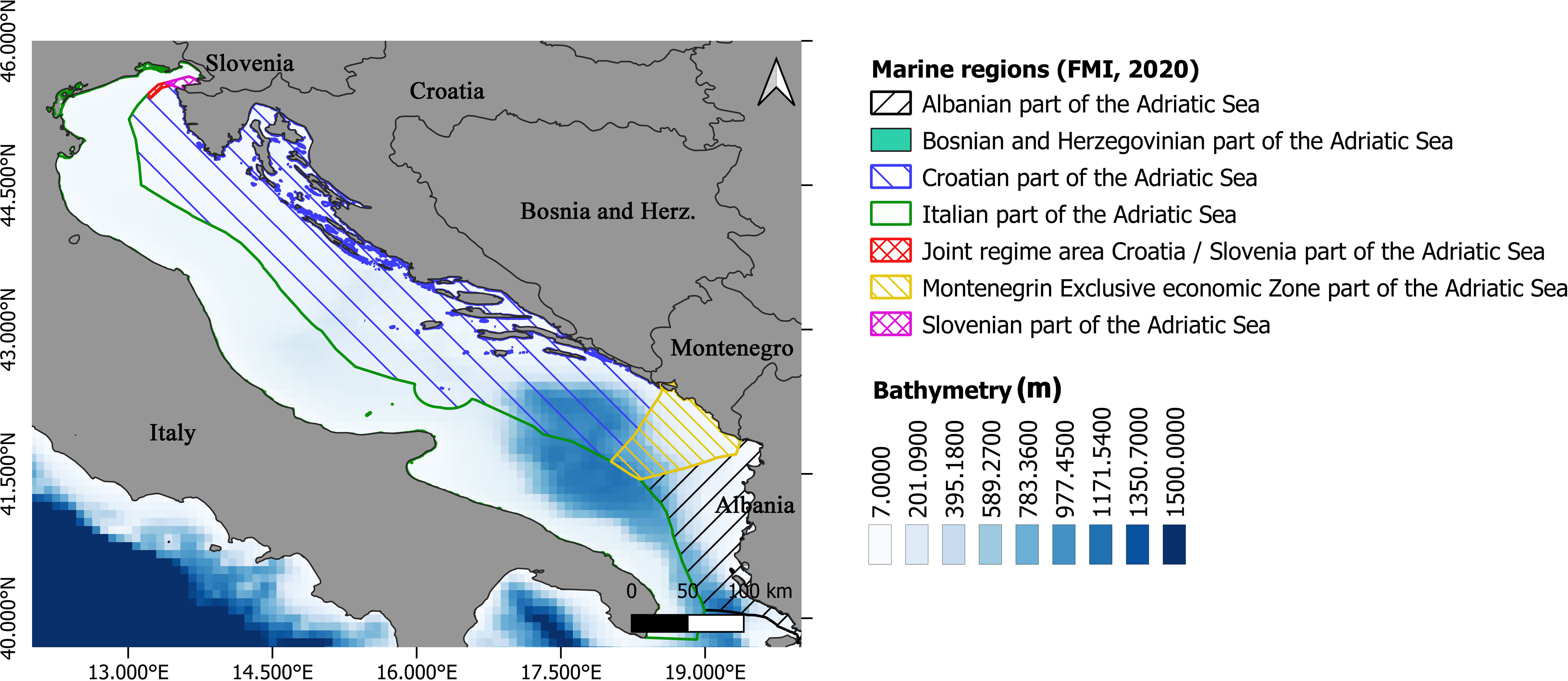
Figure 1 Map of the Adriatic Sea and its marine regions (Flanders Marine Institute, 2018).
Different area-based conservation measures have been established in the Adriatic Sea, by either international laws or national regulations. Here, a review of the measures that were active during 2019 is presented. Areas have been classified into six main categories: biological protection areas (BPAs), coastal ban, FRAs, Croatian trawling ban areas, MPAs, and offshore platforms (Figure 2).
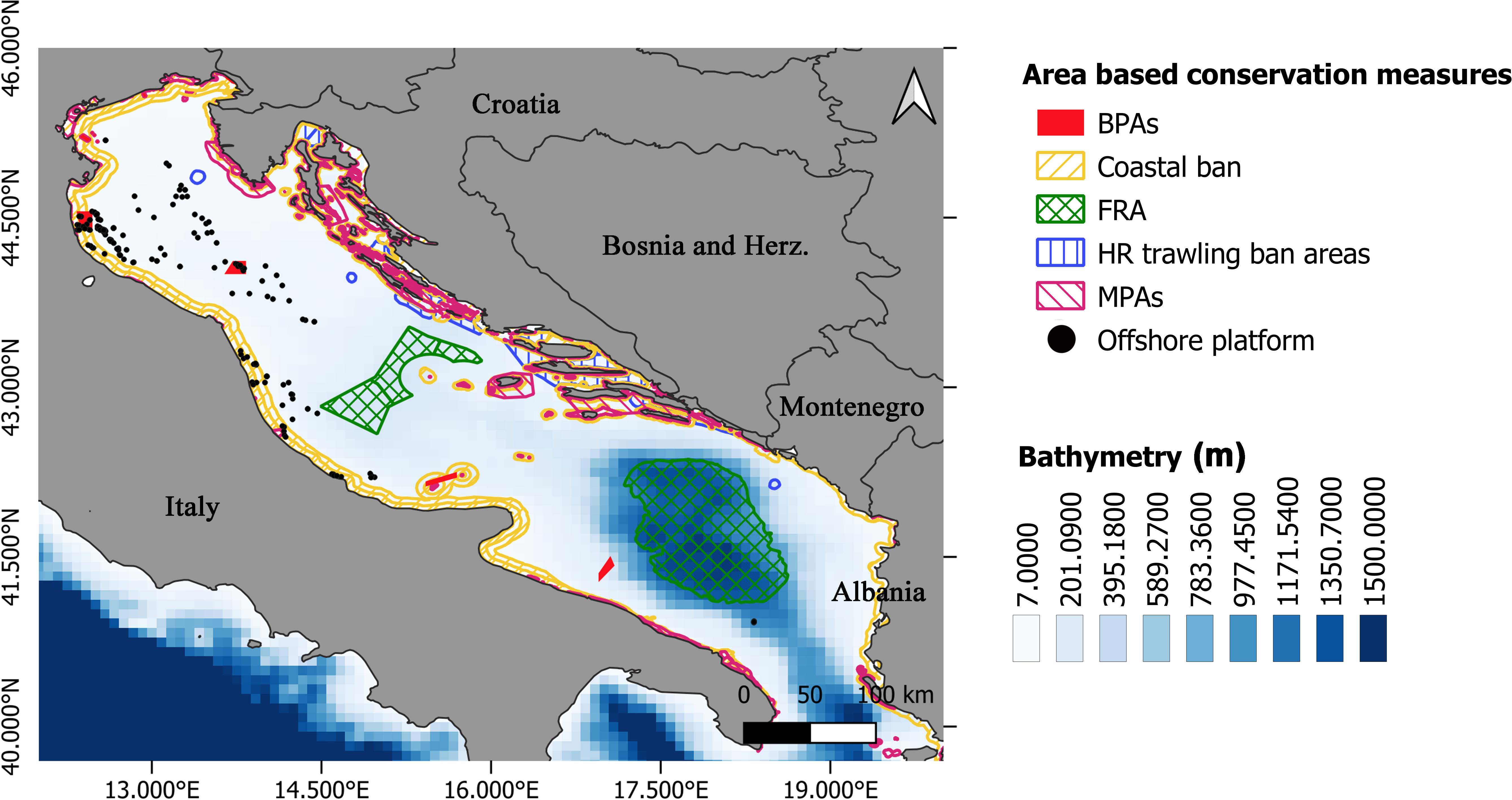
Figure 2 Area-based conservation measures established in the Adriatic Sea.
BPAs are marine areas established by the Italian government (zone di tutela biologica in Italian) that have been recognized as grounds for spawning and/or a nursery of economically important species or as areas depleted due to local over-exploitation. In BPAs, fishing activities are limited or prohibited in order to preserve/recover commercial fish stocks (Tassetti et al., 2019).
Seven BPAs were in force in 2019 in the Adriatic Sea, six of them banning bottom trawling permanently and one (Tremiti BPA) prohibiting this activity temporally, from April (01/04) to October (31/10) (D.M. 22 gennaio, 2009).
Generally, in the Mediterranean Sea, trawling activities are banned within the 40-m to 60-m isobath and/or within 3 nautical miles (nm) to 6 nm from the coast. Nevertheless, in the Adriatic Sea, some countries apply less restrictive legislation in this regard.
In Albania, trawling activities are banned within the 30-m isobath (Law No. 7908 of 5 April 1995 on fisheries and aquaculture and Regulation No. 1 of 26 March 1997).
The trawling coastal ban in Croatia varies depending on the area; generally, it is set at 1 nm from the mainland and island coast, although in some areas, it goes up to 2 nm (e.g., around Galijula, Lastovo, Glavat, and Mljet Islands) and up to 3 nm around Blitvica and Jabuka (STECF, 2019). Furthermore, trawling is prohibited in numerous bays and channels (e.g., Cres Bay and Vindol and Velebit Channels).
In Italy, trawling activities are prohibited within 3 nm from the coast or the 50-m isobath, as amended by the EU Fisheries Regulation (1967/2006). In addition, since 2012, the ban has been extended up to 6 nm or the 60-m isobath for vessels with length overall (LOA) >15 m from the beginning of the biological rest period until 31 October (STECF, 2019). The biological rest period is established each year by a ministerial decree, prohibiting trawling activities in maritime compartments for 30 consecutive days. In 2019 in the Adriatic Sea, an extension of up to 6 nm was set from 29 July until 31 October, only with the exception of maritime compartments of Monfalcone and Trieste.
Fishing with bottom trawls is banned at a distance of less than 3 nm from the coast or at a depth of 50 m in Montenegro; moreover, this activity is prohibited in the area of the Bay of Boka Kotorska (LMFM, 2009).
Slovenia, which counts with a limited marine fishing area, allows trawling up to 1.5 nm from the coast (Commission Implementing Regulation (EU) 2017/2383).
Multiple areas have been established by the Croatian government in which trawling is banned for some part of the year or weeks, which makes the system of trawl fishing regulations complex (Bitunjac et al., 2016). Bottom trawling is forbidden during 6 months in the spring–summer period in most part of the channel area in the central Adriatic, while in the winter–autumn period, trawling is allowed only 2 days per week (STECF, 2019). Two areas are settled in the Rijeka Bay in order to divide it in half; the trawl ban is alternated every 6 months between each area.
Also, trawling is forbidden within the 12 nm around Jabuka/Pomo Island on Saturdays and Sundays in order to protect recruits of Merluccius merluccius and Nephrops norvegicus. In addition, trawling activities are banned in some areas because of the presence of explosive materials. Above all the territorial sea, 30% is permanently closed to trawling, while around 10% is partially protected with a 100- to 300-day ban (STECF, 2019). In total, 19 areas have been identified as Croatian non-trawling areas.
As of 2019, two different FRAs have been established in the Adriatic Sea, each of them with a different objective. The large deep-water FRA aims to protect deep-sea habitats and resources and was the first confirmed (REC. GFCM/29/2005/1, 2015). It is located in the southern Adriatic Pit, and within it, the use of trawl nets is permanently prohibited at depths beyond 1,000 m.
In the central Adriatic, the Jabuka/Pomo Pit was settled to contribute to the protection of essential fish habitats for European hake (M. merluccius) and Norway lobster (N. norvegicus) (REC. GFCM/41/2017/3, 2017) and is divided into three zones. Bottom trawls are permanently forbidden within zone A (central area), while in zones B and C, trawling is prohibited from 1 September to 31 October, and only authorized vessels are allowed to fish during the rest of the year. In addition, in zone B (closer to the Italian coast), authorized vessels are not allowed to fish for more than two or one fishing days per week. At the other side, in zone C (closer to the Croatian coast), authorized bottom trawlers are entitled to fish only during weekends from 05:00 until 22:00.
A total of 320 areas fall within this category, which includes nationally designated MPAs and Natura 2000 sites. Data have been retrieved from the Protected Planet website (UNEP-WCMC, 2022). In Table 1, a summary of the Adriatic MPAs according to their designation and the country in which the area jurisdictionally resides within is presented.
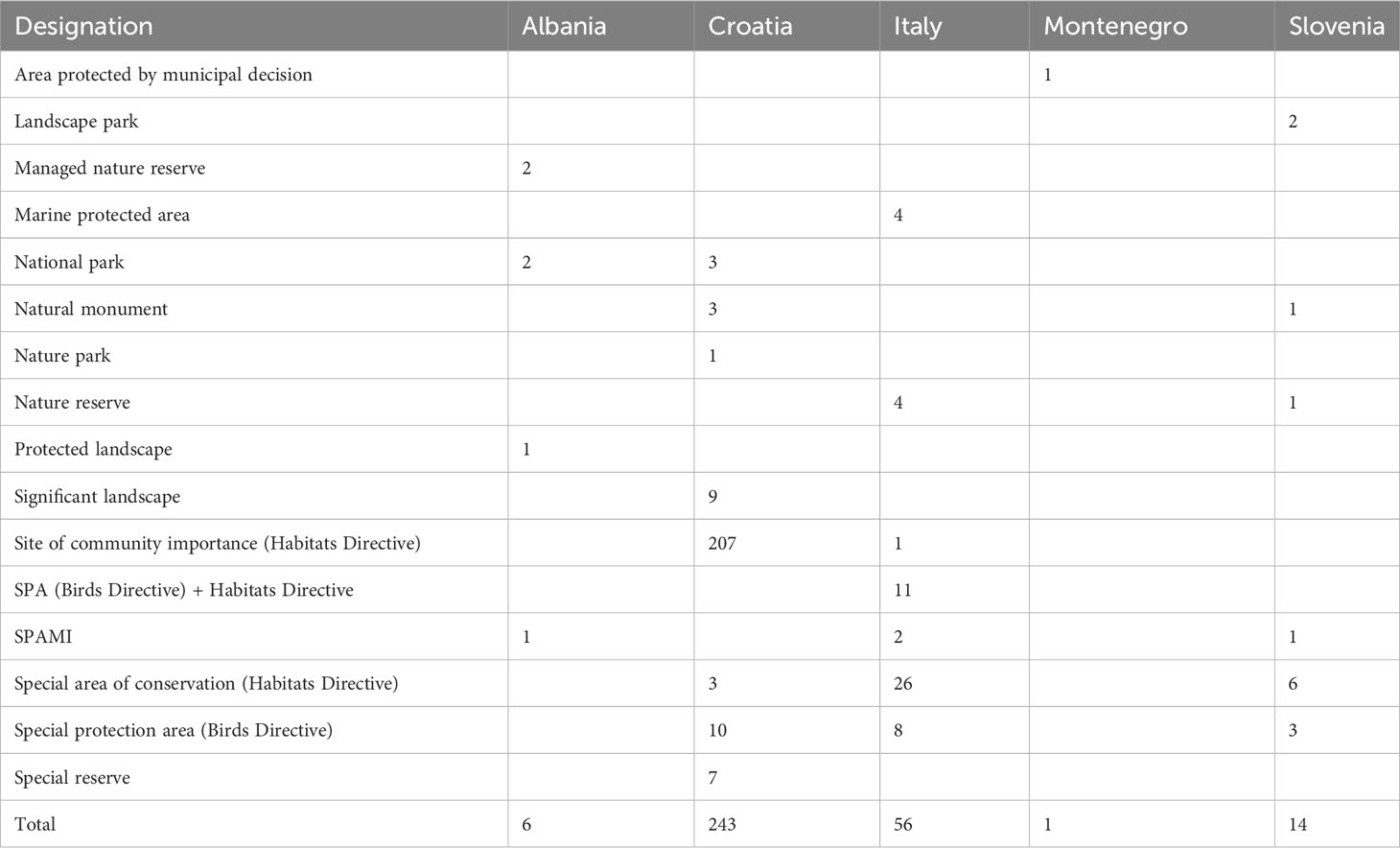
Table 1 Summary of Marine Protected Areas by designation and country.
This category encompasses areas with different typologies of designation, and within each designation category, allowed uses can vary considerably. Therefore, the authors have decided to assess MPAs as if trawling was permanently banned in all areas.
A total of 193 offshore structures are located in the Adriatic Sea, most of them in the northern side. According to regulations, fishing activities are banned in the safety zone of 500 m around each oil and gas installation.
In order to evaluate the compliance of trawling bans in the Adriatic Sea, an intersection between the managed areas and the bottom trawling activity was performed. To this aim, a spatial layer with all area-based conservation measures described before was created, considering for each category a time range for those areas with temporal bans. Thus, offshore platforms, MPAs, and coastal areas were always considered closed areas. Additionally, in Italy the coastal ban was extended to 6 nm from August to October 2019; this extension was considered for that period. Regarding the other categories, each area was categorized according to its own temporal range.
Bottom trawling was identified by analyzing raw Automatic Identification System (AIS) data, purchased from a private provider (www.astrapaging.com). Terrestrial AIS data at a 5-min resolution for all fishing vessels operating in the Adriatic Sea in 2019 were analyzed applying the R workflow available in the R4AIS code repository (Galdelli et al., 2021a), further enhanced in recent experiments (Coro et al., 2022; Pulcinella et al., 2023) in order to obtain monthly bottom trawling activity data at a 0.01° resolution.
The managed areas’ layer was spatially joined with the monthly trawling fishing activity data, and the overall activity within each area was computed. Assuming a lognormal distribution of fishing activity for the whole Adriatic, the lower and upper confidence limits were calculated. These limits were used to categorize each area according to the relative trawling intensity (low/medium/high) performed within each area taking into account the size of the areas.
In addition, the same procedure was applied to each category of managed areas, splitting time to obtain information regarding the open and closed periods. The time ranges used were from August to October for coastal bans considering the 6-nm ban as closed and the 3-nm one as open, from September to October as closed for the FRAs, and from April to October for BPAs and Croatian managed areas. Although in the Croatian managed areas some sub-areas have different temporal ranges, we decided to apply the April–October range as it was the most extended temporal closure. This investigation was not applied for MPAs and offshore structures as these areas remained always closed to trawling.
A total of 549 features representing area-based conservation measures, prohibiting bottom trawling in almost 50,000 km2, were identified for the Adriatic Sea in 2019. Around 88% of the features fell within the categories of Natura 2000 and offshore platforms, covering only 18% of the total trawling banned area (Table 2). Coastal bans and FRAs, although the least abundant, were the first and second most extensive closed areas, accounting for about 75% of the total area. Notably, the Jabuka/Pomo FRA consists of three different areas; thus, the number of features was 4 instead of 2. Additionally, the coastal ban surface was calculated considering only the Italian ban of 6 nm, to avoid counting the 3-nm surface twice.
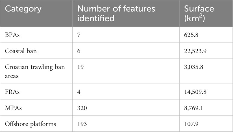
Table 2 Number and surface of area-based management measures in force in 2019, by category.
Analyzing bottom trawling fishing activity performed throughout 2019, it was observed that no fishing was exerted within 399 (73%) (Table 3) of the managed areas, most belonging to MPAs and offshore platforms, where 86% and 62% of the areas, respectively, fell into this category (Figure 3; Table 4). Thus, trawling activity was performed within 27% of managed areas, with a low intensity in 14% of the areas, medium in 11%, and high in 2%. High-intensity fishing activity was observed only within offshore platforms bans, while coastal ban areas and FRAs were the only managed areas not reporting null intensity, meaning that there was at least one fishing event in 2019.
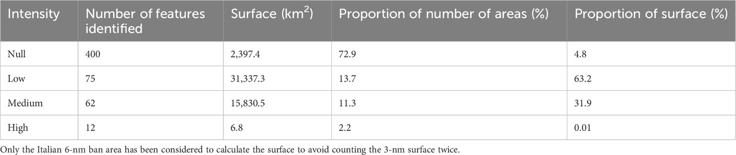
Table 3 Summary of the number and surface of area-based management measures in force in 2019 categorized by the fishing intensity registered.
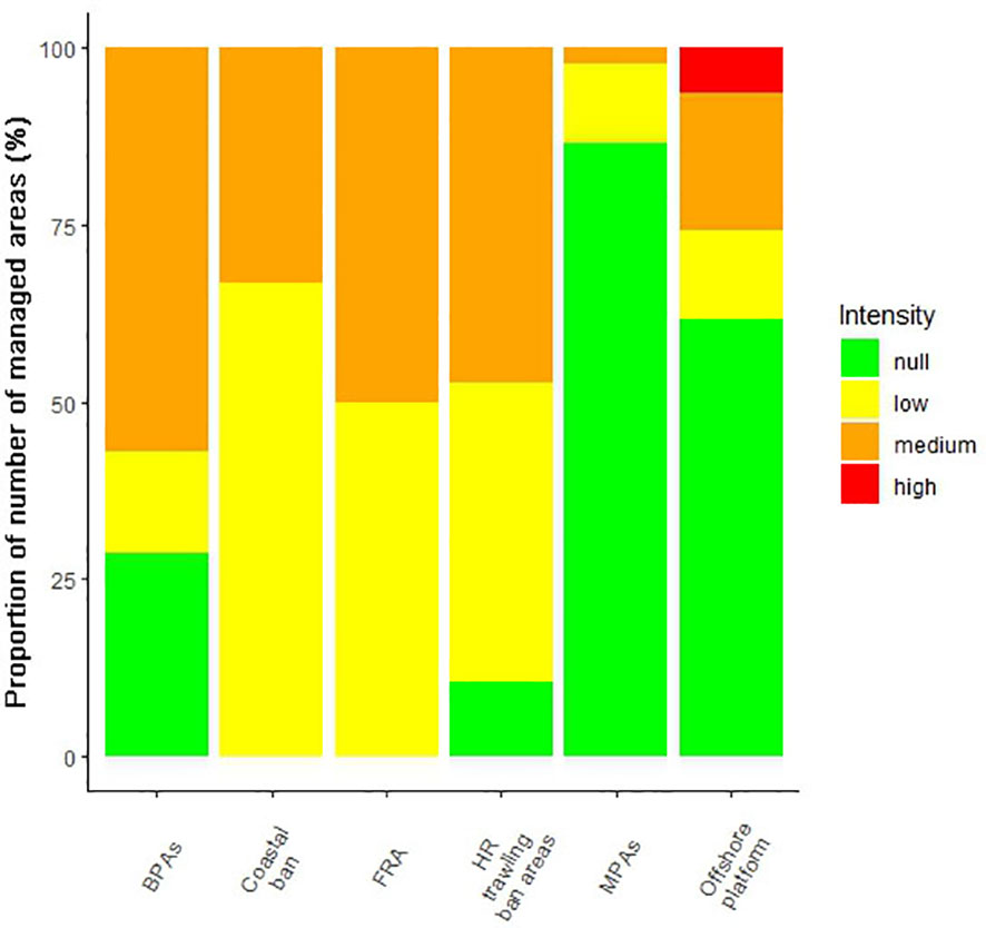
Figure 3 Percentage of areas by conservation measure categories classified according to fishing intensity performed in 2019 (BPAs, biological protection areas; FRA, Fisheries Restricted Areas; HR, Croatian; MPAs, Marine Protected Areas).
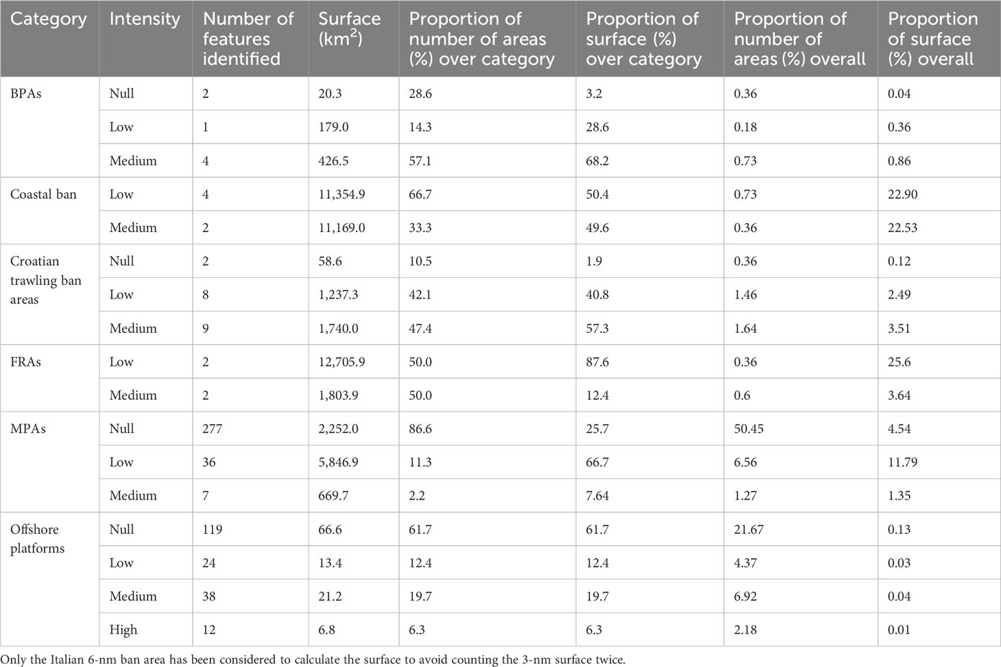
Table 4 Summary of the number and surface of area-based management measures in force in 2019 by category and fishing intensity registered and proportions over each category and overall.
Exploring monthly trawling activity performed within the managed areas, it was noticed that in August, in 91% of the areas, there was no interest in trawl fishing, while the lowest proportion of areas with null activity was reached in April (86%). This variability in the number of areas with null activity was particularly visible within MPAs and BPAs (Figure 4).
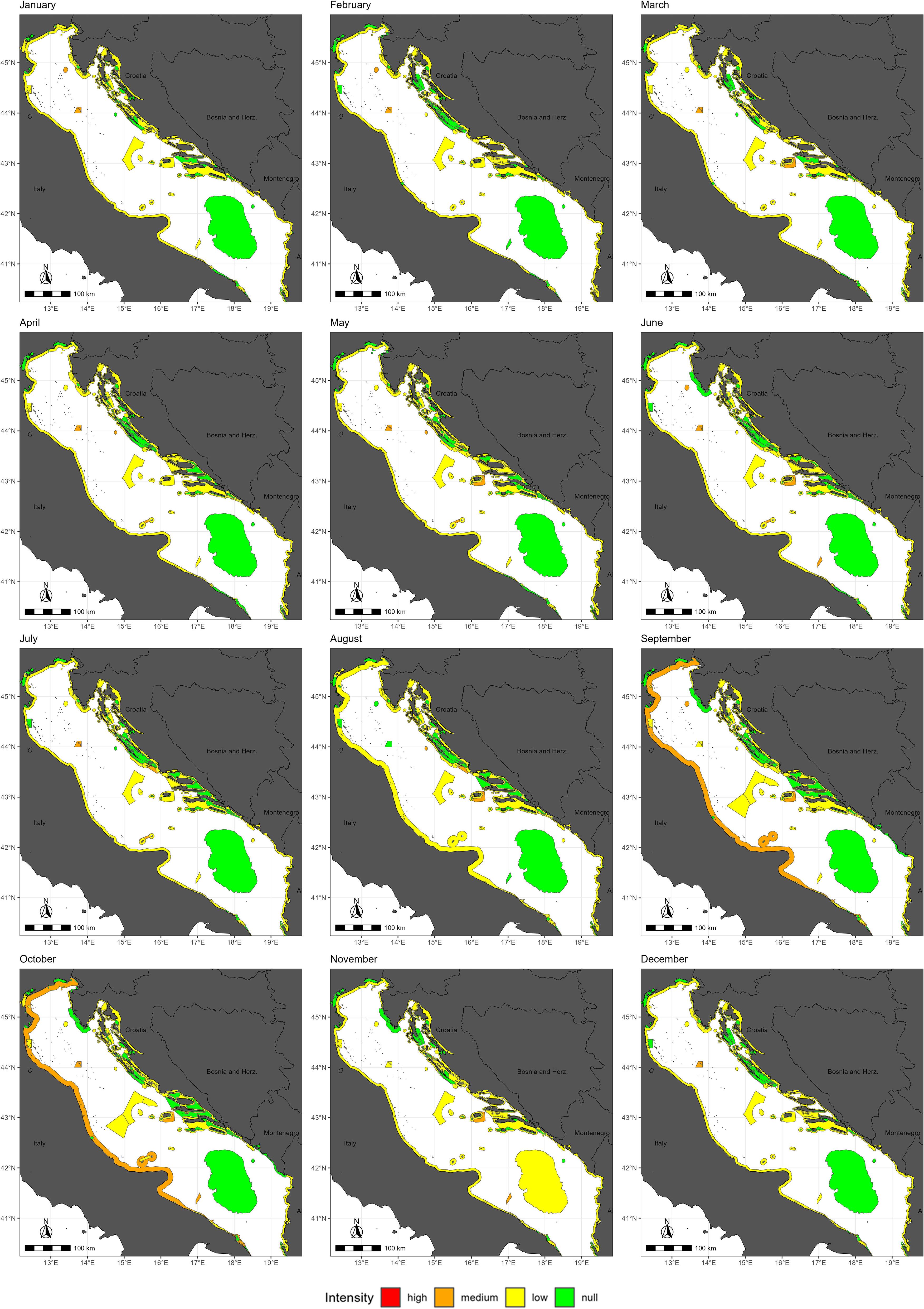
Figure 4 Monthly fishing intensity exerted within the managed areas during 2019.
In 2019, fishing was carried out within up to 144 managed areas mainly with a low intensity, particularly during August, when this intensity was reached in 72% of the overall fished areas (Figure 5). The fraction of areas with a medium fishing intensity was higher with respect to the low-intensity one only in July, with 49% and 45% each. The highest percentage of areas with a high trawling intensity was in April (14%), while the lowest was in August (2%).
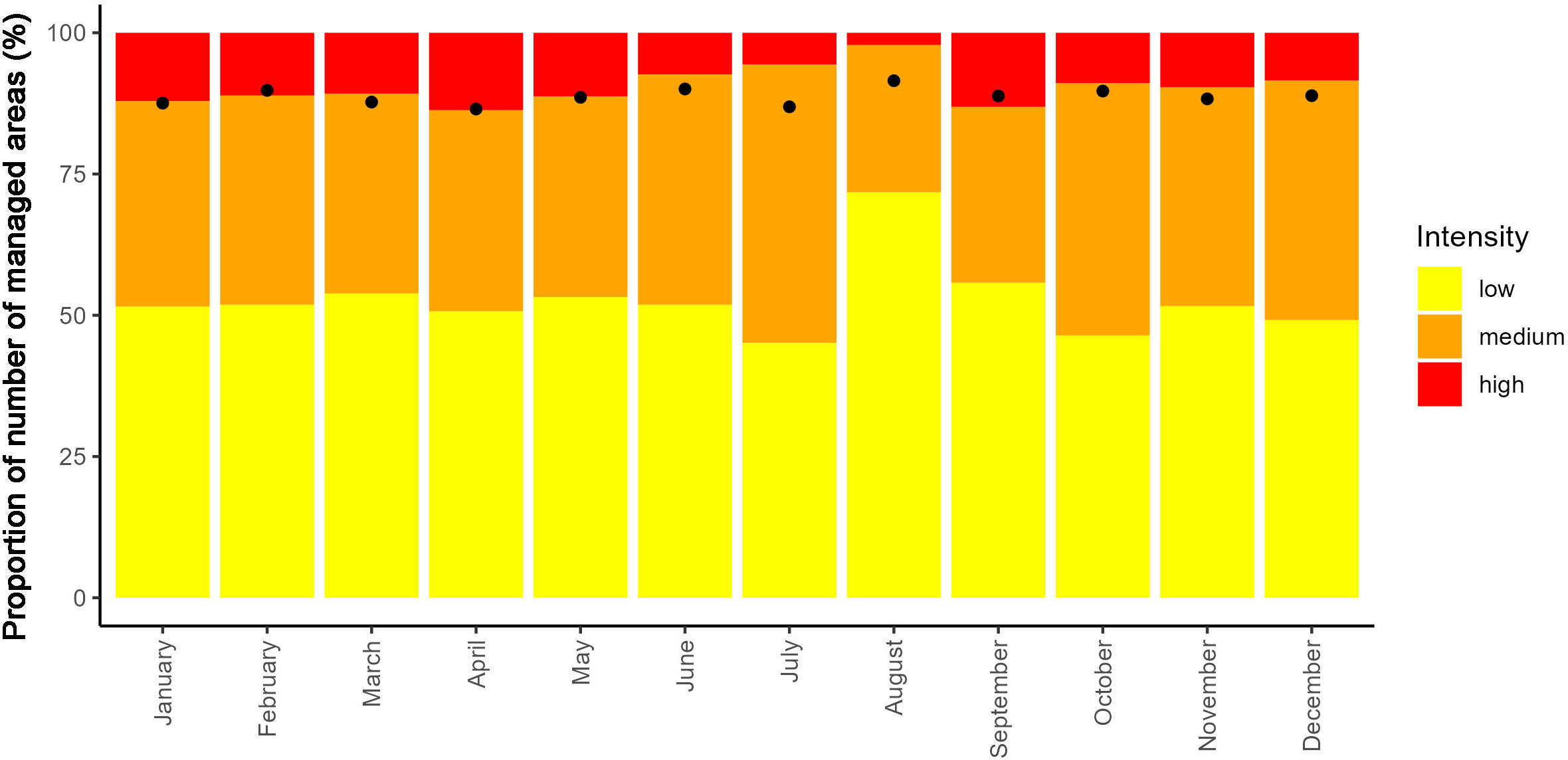
Figure 5 Percentage of managed areas interested in trawling activities classified according to the fishing intensity performed monthly. Dots represent the overall percentage of managed areas with null fishing intensity.
An in-depth inspection of the monthly variability of fishing intensity was carried out for each category of managed area (Figure 6). For BPAs, it was observed that fishing prohibition was respected in six out of seven areas during August (Figure 6A), with the only temporarily closed BPA (Tremiti area) being the only BPA reporting fishing activity. The trawling ban was respected for the whole year only within two areas, while most BPAs reported a low fishing intensity. The highest number of BPAs reporting a medium intensity of trawling activity was observed in June, when four BPAs were substantially fished.
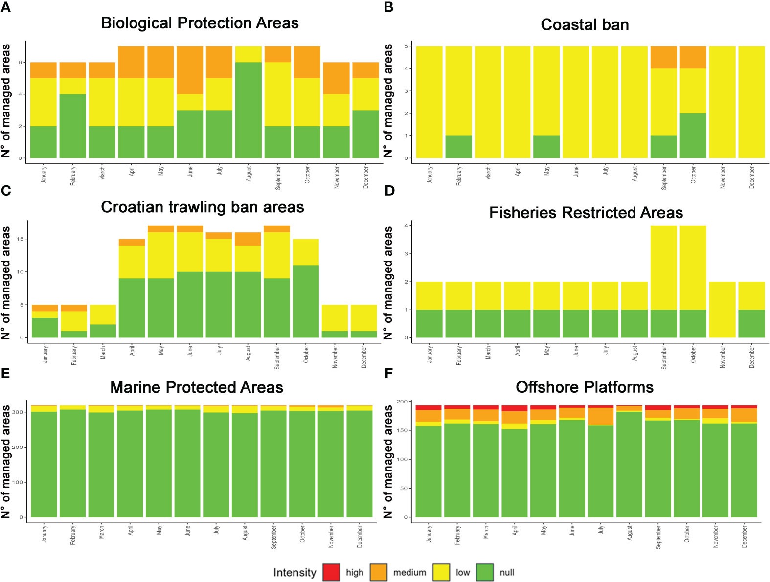
Figure 6 Monthly frequency of each category of area-based conservation measures classified according to the fishing intensity performed within each area. (A) Biological Protection Areas; (B) Coastal ban; (C) Croatian trawling ban areas; (D) Fisheries Restricted Areas; (E) Marine Protected Areas; (F) Offshore platforms.
Coastal ban areas were particularly affected by fishing activities, mainly with a low intensity (Figure 6B) with the exception of September and October, when the intensity within the Italian 6-nm area was medium. In contrast, the trawling prohibition was fully respected in February and May in the Slovenian coastal area, in September in the Montenegrin area, and in October in both coastal areas (Figure 3).
Among Croatian trawling ban areas, we noticed a great variability in the number of areas in force throughout the year (Figure 6C). Only within 5 out of 19 areas was the trawling prohibition fully followed during 2019; moreover, in some months, more than 50% of areas were not targeted by fishing activities. Only in February, March, November, and December was the fraction of areas with a low intensity of trawling was higher than that of the null one. A medium intensity of trawling was not always reported, and when it was, it occurred only within one area except from August, when there were two affected areas.
In September and October, the number of FRAs in force was double that for the rest of the year as it is in this period when zones B and C of the Jabuka/Pomo FRA are completely closed to bottom trawling (Figure 6D). No fishing activities were observed within the deep-sea FRA, except for November, when a low intensity was reported (Figure 3). Differently, within the Jabuka/Pomo FRA, trawling activity was always present with a low intensity.
No fishing activity was recorded between 297 and 307 out of the overall 320 MPAs; thus, more than 90% of these areas were always exempt from trawling (Figure 6E). A low intensity of trawling was reported in all months, reaching its highest fraction in August, when this intensity was observed in 20 areas. No areas with a medium intensity were identified during February, while in November, the highest number of areas (six) reported this intensity.
Regarding the 500-m ban around offshore platforms, the month with less fishing activity was August, when no trawling was reported in 182 areas (94%), while low, medium, and high intensities were observed in two, eight, and one platforms, respectively (Figure 6F). Instead, April was the month with more fishing intensities, when 152 platforms recorded no trawling; 10, low intensity; 21, medium intensity; and 10, high intensity. Offshore platforms were the only typology of management area to report all intensity categories in each month.
Although a high intensity of fishing was observed only within offshore platforms, when the same thresholds were applied to a larger time range, in order to study the intensity variability between open and closed periods, areas with a high intensity increased. Within BPAs, the temporarily closed area (Tremiti BPA) reported a high trawling intensity when in force, while Barbara BPA, which monthly reported mainly a medium intensity, became a high-intensity area (Figure 7). Moreover, only one area remained with a low trawling intensity and two with a medium intensity, while as mentioned before only two areas were completely free of fishing.
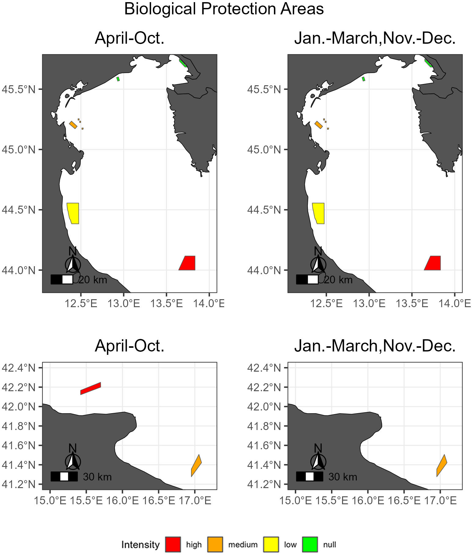
Figure 7 Trawling intensity within biological protection areas during the closed period (left) and the open one (right).
Regarding the coastal closures, only within the Italian ones, at both 3 nm and 6 nm, the fishing intensity reached a medium level, while in the other areas it remained low.
During the closed period, almost half of the Croatian trawling areas reported a low trawling intensity, while only within one was the intensity observed high (Figure 8). Moreover, during the open period, the fishing intensity was higher in the northern areas (medium), while in the southern areas it was low.
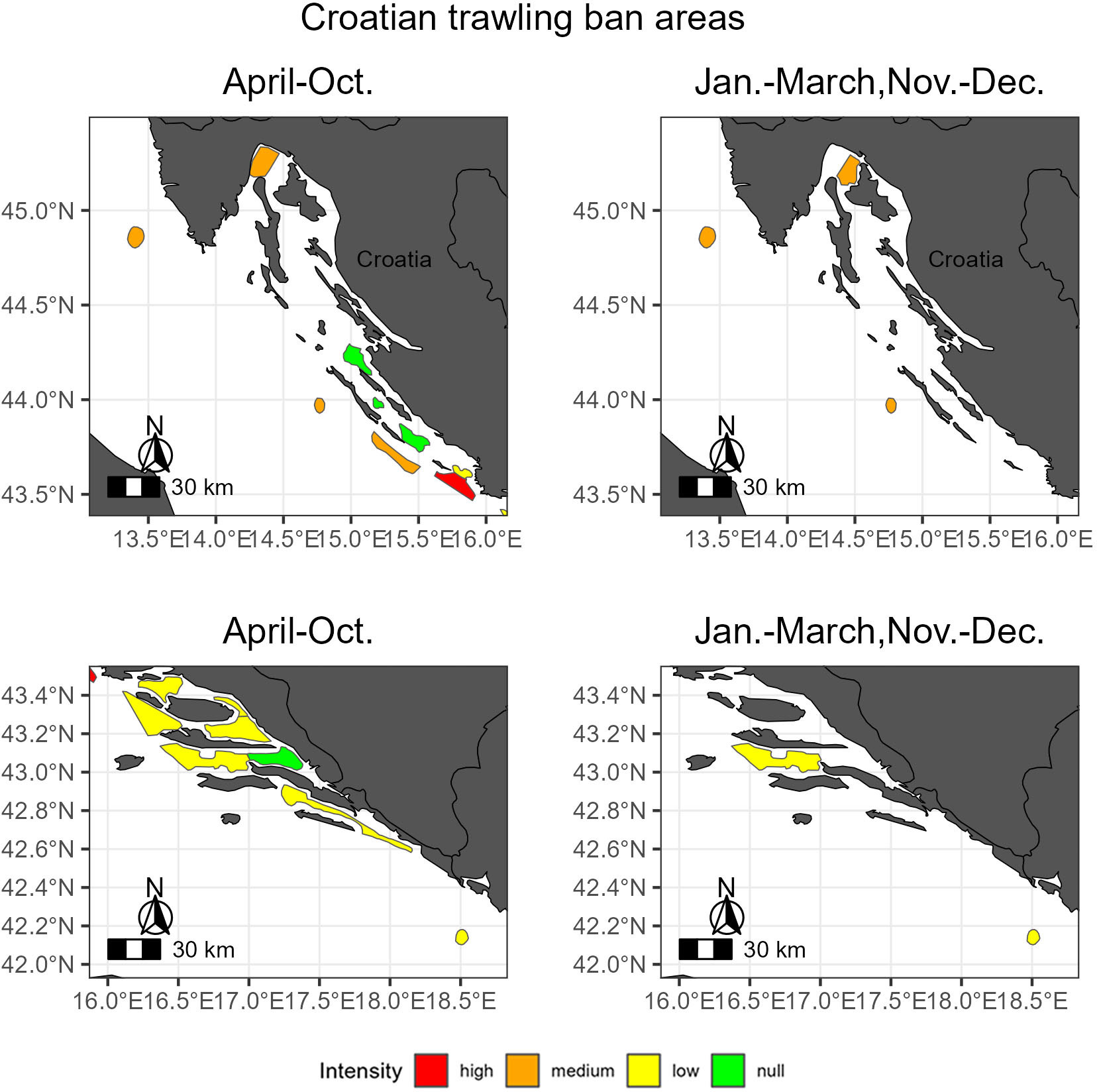
Figure 8 Trawling intensity within Croatian trawling ban areas during the closed period (left) and the open one (right).
All three zones of the Jabuka/Pomo Pit FRA, located in the central Adriatic Sea, reported a low trawling intensity during the period in which fishing was prohibited (September–October), while when fishing was banned, only in the central zone did the trawling intensity rise to a medium level (Figure 9). When applying the time range of the Jabuka FRA closures to the deep-sea FRA, located in the southern pit of the Adriatic Sea, the fishing intensity was null when all three zones of the Jabuka FRA were active, while the intensity was low when only the central zone was closed to trawling.
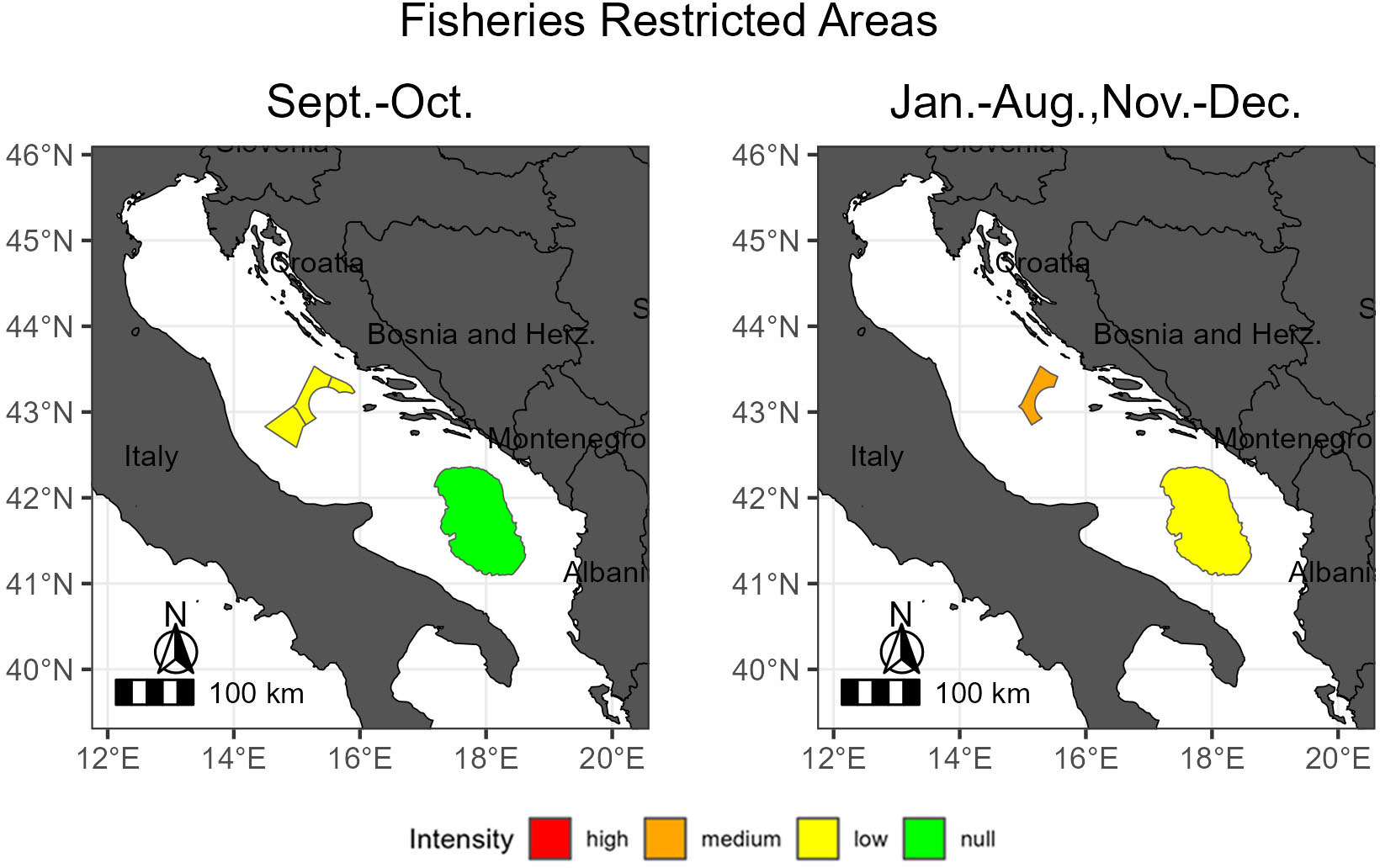
Figure 9 Trawling intensity within Fisheries Restricted Areas during the closed period (left) and the open one (right).
It is well known that area-based conservation measures could have a positive effect on the environment by protecting ecosystems and producing conservation benefits to internal fish assemblages and neighboring areas by spillover processes (Murray et al., 1999; Russ and Alcala, 2004; Russ et al., 2008). The effectiveness of managed areas firmly relies on compliance by fishermen; as a consequence, enforcement is crucial. However, it is not guaranteed as patrolling is financially expensive, is time consuming, and is reduced to a fine temporal and spatial scale. This study presents an easily reproducible assessment of the compliance of fishery restrictions in managed areas through the yearly analysis of AIS data.
The results of this study, which summarizes the 549 marine managed areas established in the Adriatic Sea that banned or restricted bottom trawling activities, have highlighted that the compliance with managed area regulations was not fully respected in 2019. Although no fishing activities were identified in 73% of the managed areas, the fraction of the surface covered by these areas represented only 5% of the study area. Among areas with no fishing activity, MPAs were the most effective category as no fishing activity was reported in 87% of them. Despite 95% of the surface of managed areas was interested in bottom trawling, more than half of the protected surface was fished with a low intensity, whereas 30% was subjected to a medium fishing intensity. Fortunately, only 0.01% of the managed surface, concentrated in offshore platforms bans, was trawled with a high intensity. Even though this could be beneficial for the environment, as the extent of highly fished areas was small, it still affects security for which bans around offshore platforms were established. Most managed areas with a low trawling intensity fell within the MPA category although they represented only 19% of the surface interested in low-intensity fishing. Regarding areas with a medium trawling intensity, coastal areas, represented only by Italian coasts, were the most extensive category. Monthly analysis highlighted that 91% of the managed areas reported no trawling activities during August, probably due to the biological rest period established during summer months. Moreover, right before the biological rest period, in July, the highest fraction of areas with a medium trawling intensity was observed, which probably relates to the propensity of fishermen to increase their benefits before the mandatory closure of bottom activities.
Different researchers have studied the enforcement of managed areas, but they have focused on a specific category (Harasti et al., 2019; Tassetti et al., 2019; Wong and Yong, 2020), especially MPAs (Guidetti et al., 2008; Arias et al., 2015; Nunes et al., 2023). To the best of the authors’ knowledge, this study presents the first assessment of the compliance of fishing restrictions within multiple managed areas in a basin where different states compete for fishing resources. However, some considerations must be taken into account as information regarding Marine Protected Areas does not represent all protected areas completely, because the guarantee of the quality of the public data is up to the data holders, and trawling is not prohibited within all the MPA extensions. Nevertheless, we assumed that the combination of the available data could provide a general insight regarding conservation and management within Adriatic MPAs. Furthermore, it must be pondered that some of the managed areas overlap, because they were designed to extend the protection of a previously established area (e.g., the Miramare BPA that enlarges the protected surface of the Miramare MPA); thus, references on the overall protected surface are slightly biased.
New management areas are being established in the Adriatic Sea in recent years; for example, in 2021 the Bari Canyon FRA was established to contribute to the protection of vulnerable marine ecosystems (REC. GFCM/44/2021/3, 2021). This area is divided into two zones, a main protection zone (zone A), where fishing activity is prohibited, and a buffer zone (zone B), where although trawling is forbidden some authorized fishing activities are allowed. The establishment of new areas is a good step toward achieving the 14th Sustainable Development Goal and thus conserve and use sustainably oceans and their resources. Although without efficient monitoring, control, and surveillance (MCS) plans that ensure the full compliance of management areas and financial support to control activities, success in protecting the environment and resources cannot be guaranteed.
It has been demonstrated that an increase of enforcement can have a rapid positive effect on fish populations (Kelaher et al., 2015); therefore, investments should be done to ensure fishery compliance. To this aim, strengthening penalties could have a positive effect as fishermen’s fear of sanctions promotes compliance (Read et al., 2015; Bergseth and Roscher, 2018). In addition, dissemination of benefits of fishing closures may increase voluntary compliance among commercial fishermen as has happened with recreational fishers in other areas (Arias and Sutton, 2013). In some cases, in order to avoid the discontent of fishers, the establishment of temporarily closed areas has been considered a possible compromise. Nevertheless, the present study has demonstrated that temporary closures do not ensure compliance with fishing bans; moreover, other authors do not consider temporal closures to be as effective as permanent bans (Day et al., 2012; Rodríguez-Rodríguez et al., 2016).
In agreement with other studies (McCauley et al., 2016; Kurekin et al., 2019), here the power of AIS data as a tool to monitor potential illegal fishing within managed areas has been confirmed. An effective MSC plan would rely on the analysis of tracking data to provide decision-makers with the evidence required to evaluate mitigation strategies. However, it must be considered that our assessment is potentially biased due to AIS coverage as this tracking system is mandatory only for European fishing vessels with an LOA exceeding 15 m; therefore, smaller fishing boats and those from countries outside the EU (Albania, Montenegro, and Bosnia and Herzegovina) may not be represented. This weakness could be overcome by integrating AIS with other satellite technologies such as vessel monitoring systems (VMSs) and synthetic aperture radar (SAR), which would allow the assessment of smaller vessels and those with disabled transponders (Kurekin et al., 2019; Rowlands et al., 2019; Galdelli et al., 2021b). Besides integration with other digital technologies, further studies focusing on the assessment of compliance should analyze the temporal variabilities of fishing activities in short-term variations in order to drive controls to increase the efficiency of compliance patrols (Davis and Harasti, 2020). Furthermore, it should be considered that the use of aggregated fishing data may add some biases to these studies, as when trawling activity is performed close to boundaries, the activity can be attributed to an internal cell, especially when fishing activity data are intersected with small managed areas (i.e., offshore platforms). Last but not least, analysis of compliance is not enough to understand the value of area-based conservation measures, and thus, assessing the benefits to fish populations becomes crucial (Hilborn and Ovando, 2014). Moreover, as highlighted in the final agreement of the recent Conference of the Parties (COP 27), in order to achieve conservation of biological diversity, there is a strong need to interlink the global crises of climate change and biodiversity loss. Therefore, future studies should not only focus on the state of marine resources and ecosystems but also consider the effects that climate variability has and will have on marine species and how these will affect economies, particularly future fisheries.
The data analysed in this study is subject to the following licenses/restrictions: AIS raw data is not anonymous and owned by CNR. Requests to access the aggregated datasets should be directed to CF, Y2FybWVuLmZlcnJhdmVnYUBjbnIuaXQ=.
All authors listed have made a substantial, direct, and intellectual contribution to the work, and approved it for publication.
This work has been funded by the EcoScope European project within the H2020-EU.3.2.-SOCIETAL CHALLENGES program, with Grant Agreement ID 101000302.
The authors would like to thank reviewers for many helpful comments, which have improved the initial version of this study. In addition, the authors would like to express their heartfelt gratitude to G. Coro from the Institute of Information Science and Technologies (ISTI) for his insightful advice and towering support throughout the current study. The research leading to these results has been conceived under the international PhD program “Innovative Technologies and Sustainable Use of Mediterranean Sea Fishery and Biological Resources” (www.FishMed-PhD.org) representing partial fulfilment of the requirements for the PhD thesis of CF.
The authors declare that the research was conducted in the absence of any commercial or financial relationships that could be construed as a potential conflict of interest.
All claims expressed in this article are solely those of the authors and do not necessarily represent those of their affiliated organizations, or those of the publisher, the editors and the reviewers. Any product that may be evaluated in this article, or claim that may be made by its manufacturer, is not guaranteed or endorsed by the publisher.
Adyasari D., Pratama M. A., Teguh N. A., Sabdaningsih A., Kusumaningtyas M. A., Dimova N. (2021). Anthropogenic impact on Indonesian coastal water and ecosystems: Current status and future opportunities. Mar. pollut. Bull. 171, 112689. doi: 10.1016/j.marpolbul.2021.112689
Amoroso R. O., Pitcher C. R., Rijnsdorp A. D., McConnaughey R. A., Parma A. M., Suuronen P., et al. (2018). Bottom trawl fishing footprints on the world’s continental shelves. Proc. Natl. Acad. Sci. 115 (43), E10275–E10282. doi: 10.1073/pnas.180237911
Arias A., Cinner J. E., Jones R. E., Pressey R. L. (2015). Levels and drivers of fishers’ compliance with marine protected areas. Ecol. Soc. 20 (4). Available at: https://www.jstor.org/stable/26270283
Arias A., Sutton S. G. (2013). Understanding recreational fishers’ compliance with no-take zones in the Great Barrier Reef Marine Park. Ecol. Soc. 18 (4). Available at: https://www.jstor.org/stable/26269444
Aronson R. B., Thatje S., McClintock J. B., Hughes K. A. (2011). Anthropogenic impacts on marine ecosystems in Antarctica. Ann. New York Acad. Sci. 1223 (1), 82–107. doi: 10.1111/j.1749-6632.2010.05926.x
Bastardie F., Angelini S., Bolognini L., Fuga F., Manfredi C., Martinelli M., et al. (2017). Spatial planning for fisheries in the Northern Adriatic: Working toward viable and sustainable fishing. Ecosphere 8 (2), e01696. doi: 10.1002/ecs2.1696
Bergseth B. J., Roscher M. (2018). Discerning the culture of compliance through recreational fisher’s perceptions of poaching. Mar. Policy 89, 132–141. doi: 10.1016/j.marpol.2017.12.022
Bitunjac I., Jajac N., Katavić I. (2016). Decision support to sustainable management of bottom trawl fleet. Sustainability 8 (3), 204. doi: 10.3390/su8030204
Blake G. H., Topalović D. (1996). The maritime boundaries of the Adriatic Sea (Ibru: International boundaries research unit). 1 (8).
Cacaud P. (2000). Legal analysis of the measures adopted by Mediterranean coastal states to minimize the impact of fishing activities on marine ecosystems and non-target species (Rome: FAO).
Carpi P., Scarcella G., Cardinale M. (2017). The saga of the management of fisheries in the Adriatic Sea: History, flaws, difficulties, and successes toward the application of the common fisheries policy in the Mediterranean. Front. Mar. Sci. 4, 423. doi: 10.3389/fmars.2017.00423
Casey J., Jardim E., Martinsohn J. T. (2016). The role of genetics in fisheries management under the EU common fisheries policy. J. fish Biol. 89 (6), 2755–2767. doi: 10.1111/jfb.13151
Claudet J., Osenberg C. W., Benedetti-Cecchi L., Domenici P., García-Charton J. A., Pérez-Ruzafa Á., et al. (2008). Marine reserves: size and age do matter. Ecol. Lett. 11 (5), 481–489. doi: 10.1111/j.1461-0248.2008.01166.x
Coll M., Piroddi C., Steenbeek J., Kaschner K., Ben Rais Lasram F., Aguzzi J., et al. (2010). The biodiversity of the Mediterranean Sea: estimates, patterns, and threats. PloS One 5 (8), e11842. doi: 10.1371/journal.pone.0011842
Coro G., Tassetti A. N., Armelloni E. N., Pulcinella J., Ferrà C., Sprovieri M., et al. (2022). COVID-19 lockdowns reveal the resilience of Adriatic Sea fisheries to forced fishing effort reduction. Sci. Rep. 12, 1052. doi: 10.1038/s41598-022-05142-w
Costello M. J., Ballantine B. (2015). Biodiversity conservation should focus on no-take Marine Reserves: 94% of Marine Protected Areas allow fishing. Trends Ecol. Evol. 30 (9), 507–509. doi: 10.1016/j.tree.2015.06.011
Costello M. J., Coll M., Danovaro R., Halpin P., Ojaveer H., Miloslavich P. (2010). A census of marine biodiversity knowledge, resources, and future challenges. PloS One 5 (8), e12110. doi: 10.1371/journal.pone.0012110
Davis T. R., Harasti D. (2020). Predictive modelling of illegal fishing in no-take marine protected areas. Fisheries Manage. Ecol. 27 (3), 292–301. doi: 10.1111/fme.12412
Day J., Dudley N., Hockings M., Holmes G., Laffoley D. D. A., Stolton S., et al. (2012). Guidelines for applying the IUCN protected area management categories to marine protected areas (Gland, Switzerland: IUCN), 36 pp.
Dimarchopoulou D., Dogrammatzi A., Karachle P. K., Tsikliras A. C. (2018). Spatial fishing restrictions benefit demersal stocks in the northeastern Mediterranean Sea. Sci. Rep. 8 (1), 5967. doi: 10.1038/s41598-018-24468-y
Eigaard O. R., Bastardie F., Hintzen N. T., Buhl-Mortensen L., Buhl-Mortensen P., Catarino R., et al. (2017). The footprint of bottom trawling in European waters: distribution, intensity, and seabed integrity. ICES J. Mar. Sci. 74 (3), 847–865. doi: 10.1093/icesjms/fsw194
EU (1992). Directive 92/43/EEC of Council of the European Communities of 21 May 1992 on the conservation of natu-ral habitats and of wild fauna and flora. Off. J. Eur. Union L206, 7–50.
EU (2008). Directive 2008/56/EC (Marine Strategy Framework Directive) of the European Parliament and of the Council of 17 June 2008 establishing a framework for community action in the field of marine environmental policy. Off. J. Eur. Union L164, 19–40.
EU (2013). Regulation EU No 1380/2013 of the European Parliament and of the Council of 11 December 2013 on the Common Fisheries Policy, amending Council Regulations (EC) No 1954/2003 and (EC) No 1224/2009 and repealing Council Regulations (EC) No 2371/2002 and (EC) No 639/2004 and Council Decision 2004/585/EC. Off. J. Eur. Union, L354/22
Evans R. D., Russ G. R. (2004). Larger biomass of targeted reef fish in no-take marine reserves on the Great Barrier Reef, Australia. Aquat. Conservation: Mar. Freshw. Ecosyst. 14 (5), 505–519. doi: 10.1002/aqc.631
FAO (2005). Fishery Resources Division. Review of the state of world marine fishery resources. FAO Fisheries Technical Paper . No. 457 (Rome: FAO) 457, 235 pp.
FAO (2020). Report of the Workshop on Use of Best Available Science in Developing and Promoting Best Practices for Trawl Fishing Operations in Africa (Marrakech, Morocco: FAO Fisheries and Aquaculture Report No. 1244). doi: 10.4060/ca2074en
Flanders Marine Institute. (2018). The intersect of the Exclusive Economic Zones and IHO sea areas, version 3. Available at: https://www.marineregions.org/
Galdelli A., Armelloni E. N., Ferrà C., Pulcinella J., Scarcella G., Tassetti A. N. (2021a). R4AIS: an R workflow to process AIS data for fishery (Zenodo). doi: 10.5281/zenodo.4761890
Galdelli A., Mancini A., Ferrà C., Tassetti A. N. (2021b). A synergic integration of AIS data and SAR imagery to monitor fisheries and detect suspicious activities. Sensors 21 (8), 2756. doi: 10.3390/s21082756
Garcia S. M., Newton C. H. (1994). Responsible fisheries: an overview of FAO policy developments, (1945–1994). Mar. pollut. Bull., 528–536. doi: 10.1016/0025-326X(94)90681-5
General Fisheries Commission for the Mediterranean (GFCM). (2009). Resolution GFCM/33/2009/2 on the Establishment of Geographical Subareas in the GFCM Area of Application, Amending Resolution GFCM/31/2007/2 (Rome: General Fisheries Commission for the Mediterranean).
Guidetti P., Milazzo M., Bussotti S., Molinari A., Murenu M., Pais A., et al. (2008). Italian marine reserve effectiveness: does enforcement matter? Biol. Conserv. 141 (3), 699–709. doi: 10.1016/j.biocon.2007.12.013
Halpern B. S., Frazier M., Potapenko J., Casey K. S., Koenig K., Longo C., et al. (2015). Spatial and temporal changes in cumulative human impacts on the world’s ocean. Nat. Commun. 6 (1), 1–7. doi: 10.1038/ncomms8615
Halpern B. S., Walbridge S., Selkoe K. A., Kappel C. V., Micheli F., d’Agrosa C., et al. (2008). A global map of human impact on marine ecosystems. science 319 (5865), 948–952. doi: 10.1126/science.114934
Harasti D., Davis T. R., Jordan A., Erskine L., Moltschaniwskyj N. (2019). Illegal recreational fishing causes a decline in a fishery targeted species (Snapper: Chrysophrys auratus) within a remote no-take marine protected area. PloS One 14 (1), e0209926. doi: 10.1371/journal.pone.0209926
Hilborn R., Ovando D. (2014). Reflections on the success of traditional fisheries management. ICES J. Mar. Sci. 71 (5), 1040–1046. doi: 10.1093/icesjms/fsu034
Horta e Costa B., Claudet J., Franco G., Erzini K., Caro A., Gonçalves E. J. (2016). A regulation-based classification system for Marine Protected Areas (MPAs). Mar. Policy 72, 192–198. doi: 10.1016/j.marpol.2016.06.021
Jackson J. B., Kirby M. X., Berger W. H., Bjorndal K. A., Botsford L. W., Bourque B. J., et al. (2001). Historical overfishing and the recent collapse of coastal ecosystems. science 293 (5530), 629–637. doi: 10.1126/science.105919
Kelaher B. P., Page A., Dasey M., Maguire D., Read A., Jordan A., et al. (2015). Strengthened enforcement enhances marine sanctuary performance. Global Ecol. Conserv. 3, 503–510. doi: 10.1016/j.gecco.2015.02.002
Kurekin A. A., Loveday B. R., Clements O., Quartly G. D., Miller P. I., Wiafe G., et al. (2019). Operational monitoring of illegal fishing in Ghana through exploitation of satellite earth observation and AIS data. Remote Sens. 11 (3), 293. doi: 10.3390/rs11030293
LMFM (2009). Law on marine fisheries and mariculture. Official Gazette of Montenegro 56/09 of 14 August 2009. N, 01-2328/2.
McCauley D. J., Woods P., Sullivan B., Bergman B., Jablonicky C., Roan A., et al. (2016). Ending hide and seek at sea. Science 351 (6278), 1148–1150. doi: 10.1126/science.aad5686
Murray S. N., Ambrose R. F., Bohnsack J. A., Botsford L. W., Carr M. H., Davis G. E., et al. (1999). No-take reserve networks: sustaining fishery populations and marine ecosystems. Fisheries 24 (11), 11–25. doi: 10.1577/1548-8446(1999)024<0011:NRN>2.0.CO;2
Nunes D. M., Bezerra A. C., Barros W. M., Araújo P. V., Branco-Nunes I. S., Magris R. A., et al. (2023). Evidence of illegal fishing within the largest Brazilian coastal MPA: Turning a blind eye to the obvious. Mar. Policy 147, 105324. doi: 10.1016/j.marpol.2022.105324
Pereira T. J., Manique J., Quintella B. R., Castro N., de Almeida P. R., Costa J. L. (2017). Changes in fish assemblage structure after implementation of Marine Protected Areas in the south western coast of Portugal. Ocean Coast. Manage. 135, 103–112. doi: 10.1016/j.ocecoaman.2016.11.017
Pulcinella J., Armelloni E. N., Ferrà C., Scarcella G., Tassetti A. N. (2023). Deepwater red shrimp fishery in the eastern–central Mediterranean Sea: AIS-observed monthly fishing effort and frequency over 4 years. Earth System Sci. Data 15 (2), 809–820. doi: 10.5194/essd-15-809-2023
Read A. D., West R. J., Kelaher B. P. (2015). Using compliance data to improve marine protected area management. Mar. Policy 60, 119–127. doi: 10.1016/j.marpol.2015.06.008
REC. GFCM/29/2005/1. (2015). Recommendation on the management of certain fisheries exploiting demersal and deep-water species and the establishment of a fisheries restricted area below 1000 m.
REC. GFCM/41/2017/3. (2017). Recommendation on the establishment of a fisheries restricted area in the Jabuka/Pomo Pit in the Adriatic Sea (geographical subarea 17).
REC. GFCM/44/2021/3. (2021). Recommendation on the establishment of a fisheries restricted area in the Bari Canyon in the southern Adriatic Sea (geographical subarea 18).
Rodríguez-Rodríguez D., Rodríguez J., Malak D. A., Nastasi A., Hernández P. (2016). Marine protected areas and fisheries restricted areas in the Mediterranean: assessing “actual” marine biodiversity protection coverage at multiple scales. Mar. Policy 64, 24–30. doi: 10.1016/j.marpol.2015.11.006
Rowlands G., Brown J., Soule B., Boluda P. T., Rogers A. D. (2019). Satellite surveillance of fishing vessel activity in the ascension island exclusive economic zone and marine protected area. Mar. Policy 101, 39–50. doi: 10.1016/j.marpol.2018.11.006
Russ G. R., Alcala A. C. (2004). Marine reserves: Long-term protection is required for full recovery of predatory fish populations. Oecologia 138, 622–627. doi: 10.1007/s00442-003-1456-4
Russ G. R., Cheal A. J., Dolman A. M., Emslie M. J., Evans R. D., Miller I., et al. (2008). Rapid increase in fish numbers follows creation of world’s largest marine reserve network. Curr. Biol. 18 (12), R514–R515. doi: 10.1016/j.cub.2008.04.016
STECF (2019) Annex 5: Details on closure of the coastal zone up to 6 nautical miles to all active towed gears. Available at: https://stecf.jrc.ec.europa.eu/documents/43805/2465980/Annex+5+-+Details+on+closure+of+the+coastal+zone+up+to+6+nm+to+all+active+towed+gears.pdf/72012326-e00a-4d27-82fe-828db8587535.
Tassetti A. N., Ferrà C., Fabi G. (2019). Rating the effectiveness of fishery-regulated areas with AIS data. Ocean Coast. Manage. 175, 90–97. doi: 10.1016/j.ocecoaman.2019.04.005
Trincardi F., Campiani E., Correggiari A., Foglini F., Maselli V., Remia A. (2014). Bathymetry of the Adriatic Sea: The legacy of the last eustatic cycle and the impact of modern sediment dispersal. J. Maps 10 (1), 151–158. doi: 10.1080/17445647.2013.864844
UNEP/MAP. (1995). Protocol on Specially Protected Areas and Biological Diversity in the Mediterranean (SPA/BD pro-tocol) of Barcelona Convention 1995. Available at: http://www.rac-spa.org/sites/default/files/protocole_aspdb/protocol_eng.pdf (Accessed 13 October 2020).
UNEP-WCMC. (2022). Protected areas map of the world, January 2022. Available at: www.protectedplanet.net (Accessed January, 2022).
Watling L., Norse E. A. (1998). Disturbance of the seabed by mobile fishing gear: A comparison to forest clearcutting. Conserv. Biol., 1180–1197. doi: 10.1046/j.1523-1739.1998.0120061180.x
Weigel J. Y., Mannle K. O., Bennett N. J., Carter E., Westlund L., Burgener V., et al. (2014). Marine protected areas and fisheries: bridging the divide. Aquat. Conservation: Mar. Freshw. Ecosyst. 24 (S2), 199–215. doi: 10.1002/aqc.2514
White P. S., Pickett S. T. A. (1985). “Natural disturbance and patch dynamics: An introduction,” in The Ecology of Natural Disturbance and Patch Dynamics. Eds. White P. S., Pickett S. T. A. (New York, NY, USA: Academic Press).
Keywords: fisheries management, marine managed areas, automatic identification system (AIS) data, trawling ban, Marine Spatial Planning (MSP)
Citation: Ferrà C and Scarcella G (2023) Assessment of the current status and effectiveness of area-based conservation measures banning trawling activities in the Adriatic Sea. Front. Mar. Sci. 10:1213211. doi: 10.3389/fmars.2023.1213211
Received: 07 June 2023; Accepted: 01 September 2023;
Published: 25 September 2023.
Edited by:
Cathryn Murray, Fisheries and Oceans Canada (DFO), CanadaReviewed by:
Saleem Mustafa, Universiti Malaysia Sabah, MalaysiaCopyright © 2023 Ferrà and Scarcella. This is an open-access article distributed under the terms of the Creative Commons Attribution License (CC BY). The use, distribution or reproduction in other forums is permitted, provided the original author(s) and the copyright owner(s) are credited and that the original publication in this journal is cited, in accordance with accepted academic practice. No use, distribution or reproduction is permitted which does not comply with these terms.
*Correspondence: Carmen Ferrà, Y2FybWVuLmZlcnJhdmVnYUBjbnIuaXQ=
Disclaimer: All claims expressed in this article are solely those of the authors and do not necessarily represent those of their affiliated organizations, or those of the publisher, the editors and the reviewers. Any product that may be evaluated in this article or claim that may be made by its manufacturer is not guaranteed or endorsed by the publisher.
Research integrity at Frontiers
Learn more about the work of our research integrity team to safeguard the quality of each article we publish.