 Betsabé de la Barreda-Bautista1*
 Sarah E. Metcalfe1Geoff Smith2Sofie Sjögersten3
 Doreen S. Boyd1
 Sergio Cerdeira-Estrada4Pablo López-Ramírez5
 Adolfo Magaldi6Rainer Ressl4Susana Perera-Valderrama4Hansel Caballero-Aragón4
 Oscar S. Siordia7Jonathan Couldridge8Paul Gray9
 Rodolfo Silva10
 Brigitta I. Van Tussenbroek11Edgar Escalante‐Mancera11
 Giles Foody1
- 1School of Geography, University of Nottingham, Nottingham, United Kingdom
- 2Specto Natura Ltd, Cambridge, United Kingdom
- 3School of Biosciences, University of Nottingham, Loughborough, United Kingdom
- 4National Commission for the Knowledge and Use of Biodiversity (CONABIO), Mexico City, Mexico
- 5Center for Research in Geospatial Information Sciences (CentroGeo), Mexico City, Mexico
- 6ENES-Juriquilla, Universidad Nacional Autónoma de México, Querétaro, Mexico
- 7National Geointeligence Laboratory, Merida, Yucatan, Mexico
- 8Digital and Technology Services, University of Nottingham, Nottingham, United Kingdom
- 9HybridGeospatial Ltd, Leicester, United Kingdom
- 10Instituto De Ingeniería, Universidad Nacional Autónoma De México, Ciudad de México, Mexico
- 11Instituto de Ciencias del Mar y Limnología, UNAM, Puerto Morelos, Q. Roo, Mexico
Massive influxes of holopelagic Sargassum spp. (Sargassum natans and S. fluitans) have been causing major economic, environmental and ecological problems along the Caribbean coast of Mexico. Predicting the arrival of the sargassum as an aid to addressing these problems is a priority for the government, coastal communities and the society; both mitigating the impacts and providing opportunities for its use. Lack of data concerning precise locations and times of sargassum beachings means that public and private funds are being spent inefficiently and most actions are reactive. The dynamic nature of sargassum beachings/influxes render conventional ground-based monitoring insufficient. Earth observation and cloud-based processing services offer tools to track, quantify and understand sargassum beaching remotely in a frequent, systematic and reliable manner with the temporal and spatial resolutions required for its management. In order to find the right solutions to address this problem, in this paper the needs and requirements of stakeholders are taken into consideration for the development of an Earth observation-based service to monitor sargassum along the Mexican Caribbean coast. Routine monitoring of sargassum over a large area will be cost effective and help mitigate the negative effects of sargassum influxes. The combination of imagery from Planet, specifically their SuperDove systems that provide daily data at 3 m spatial resolutions, with the freely available EU Copernicus data would be useful for many different stakeholders and potential users. A prototype of the service is presented, based on the main user requirements. The system would enable public and private organizations to allocate resources appropriately in affected areas quickly and efficiently, thereby minimizing economic, social and environmental impacts and enhancing the resilience of local communities. It would also assist the sargassum industry in the collection of fresh algae for onward processing. The system could easily be implemented for similar types of environmental monitoring in the Greater Caribbean and beyond.
1 Introduction
Holopelagic Sargassum spp (Sargassum natans and S. fluitans; sargassum from hereon) is a brown macroalgae (seaweed) that floats on the sea surface in tropical and subtropical areas of the Atlantic Ocean. It was first described in 1492, by Christopher Columbus and his fleet (Lapointe et al., 2021). It can aggregate into large rafts which may ultimately drift on to adjacent coasts. These rafts are crucial agents of connectivity and, driven by marine and air currents, serve as important conveyance systems for marine wildlife. Once reaching the coast, in small amounts, sargassum plays an important role in protecting beaches from wind and wave erosion and providing feeding areas for shoreline birds (Laffoley et al., 2011; Wang et al., 2019; García-Sánchez et al., 2020). Historically, large amounts of sargassum only occurred in the Gulf of Mexico and the Sargasso Sea (Johns et al., 2020) and nuisance accumulations of sargassum (drifts up to 3 m deep) that have had a negative impact have occasionally occurred on the shores of Caribbean islands, such as in Bermuda in 1917, and on the Caribbean coasts of Mexico and Central America (Oviatt et al., 2019). When large quantities of sargassum accumulate onshore over a short period of time it can disrupt ecological systems, fishing and tourism (Rutten et al., 2021). When it rots it releases large amounts of nutrients and organic matter that change the environmental conditions of the beaches (Van Tussenbroek et al., 2017; Chávez et al., 2020). It also releases toxic hydrogen sulphide which can cause respiratory problems and infrastructure damage (Oyesiku and Egunyomi, 2014; Hinds et al., 2016).
A significant change was observed in 2011 when a large accumulation of sargassum was recorded off north eastern Brazil. Unprecedented amounts of this sargassum were carried to the southern Caribbean, Sierra Leone, Nigeria and Ghana (Huffard et al., 2014; Oviatt et al., 2019) causing widespread economic and ecological damage (Ody et al., 2019). Possible mechanisms behind this system shift have been discussed by Johns et al. (2020). Almost every year since 2011, large quantities of sargassum have been reported across the Atlantic, giving rise to the term ‘Great Atlantic Sargassum Belt’ (Wang et al., 2019). The costs of trying to clean up sargassum across the Caribbean in 2018 was estimated at US$120 million, excluding losses from reductions in tourism (Lapointe et al., 2021). This problem is set to grow with the increasing impact of climate change and the inputs of nutrients from onshore sources (Oviatt et al., 2019; Johns et al., 2020).
Previous and ongoing research (Milledge and Harvey, 2016; Zanolli, 2019; Miranda et al., 2021; Oxenford et al., 2021; Azcorra-May et al., 2022; López-Miranda et al., 2022; Lopresto et al., 2022) is, however, showing that sargassum is also providing opportunities for exploitation and use as a natural resource. Sargassum can be used as compost, biofuel (via anaerobic digestion), livestock feed, as part of chemical processes in cosmetics, medicine or health supplement manufacturing, or to manufacture paper, building materials or bioplastics (Chávez et al., 2020). Its potential as a sustainable biofuel offers opportunities to reduce CO2 emissions from both transport and agriculture and contribute to climate change mitigation (Marx et al., 2021). However, its use in these processes requires the timely collection of beached sargassum before it begins to decay, and novel, specific and complex treatment processes to prepare it for use. These challenges hamper the up-scaling of innovative technologies using sargassum, and as far as our knowledge goes, no new technology has reached large-scale viability, although some sargassum-derived products are now available on the market.
In the past, estimated sargassum volumes were based on measurements from ships, with studies dating back to the 1830s, if not before (Gower and King, 2011). Today, satellite remote sensing or Earth Observation (EO) provides a means to understand the phenomenon in a more comprehensive and holistic way, the nature of the resulting sargassum events as well as detailed monitor in space and time (Wang et al., 2019). Sargassum influxes are highly dynamic and occur across large, often remote and/or inaccessible areas. Understanding, managing and quantifying these events requires frequent, reliable and operational monitoring capabilities over a wide area, with appropriate spatial detail. EO provides a cost-effective option for such monitoring activity. Sargassum mats are visible from space due to their characteristics: floating, long lasting and a distinctive spectral response (Gower and King, 2008). They can, therefore, be monitored using different vegetation indices, such as the Maximum Chlorophyll Index (MCI), Normalized Difference Vegetation Index (NDVI), Floating Algal Index (FAI) and Alternate Floating Algae Index (AFAI) (Hu, 2009; Gower and King, 2011; Hu et al., 2015; Maréchal et al., 2017; Hernández et al., 2020). Sargassum does not always aggregate in large mats, thus, it is not detectable by some coarse spatial resolution optical sensors (e.g., MODIS at 250m, Sentinel-3 at 300m), requiring high spatial resolution sensors for local tactical monitoring. Gower and King (2011) report the first detection of sargassum in the NW Gulf of Mexico in 2005 using MCI from MERIS at 300 m spatial resolution. Over the period 2002-2008 they noted a consistent pattern of movement, with a maximum sargassum amount in 2005 estimated at 6 million tonnes wet weight. Over recent years the use of more spatially detailed EO systems has been tested, especially those based on sensors carried by Landsat and Sentinel-2 satellites. However, these do not have the high temporal revisit required to map locally dynamic sargassum situations. Notwithstanding, such EO-based solutions generally aim to improve our understanding of sargassum, and to support the development of appropriate and cost-effective management strategies. They could be adapted to similar phenomena (e.g., harmful algal blooms) elsewhere in the world. The detection of sargassum using high spatial and temporal resolutions is attracting attention (Hernández et al., 2020; Wang and Hu, 2021; Zhang et al., 2022) but also more questions are arising associated with understanding the dynamics of sargassum near the coast (Miron et al., 2020) and the uncertainty associated with the different models used (Marsh et al., 2022).
Two linked studies, the Satellite Sargassum Monitoring System (SASAMS) and SargAssure projects, were undertaken to develop a satellite EO service to monitor sargassum. SASAMS had the long-term goal of developing a cost-effective, near-real time sargassum monitoring service for the Mexican Caribbean coast based on satellite technology, while SargAssure focused on delivering a prototype operational system based on the user requirements established during SASAMS. Together, these projects have the potential not only to deliver local solutions to the Mexican Caribbean coast, but also across much wider geographical area, contributing to the Sustainable Development Goals (SDG) 13 and 14. In this paper, the focus is on user requirements for a satellite-based sargassum monitoring service.
2 Mexico case study
The Mexican Caribbean coast (Figure 1) is ~ 900 km long, including the island and continental areas. It contains several ecosystems (e.g., mangroves, coastal dunes, seagrass meadows, coral reefs, beaches) which provide important habitats as well as ecosystem services. The region is one of the most important tourism hotspots in the country, receiving >12.5 million tourists a year and making an important contribution to national Gross Domestic Product (GDP) (Portal Ambiental, 2019): approximately 8.7% according to the OECD (2020). In the State of Quintana Roo more than US$8.6 billion/year (Ruiz-Ramírez et al., 2019) is generated, 85% of the GDP of the aforementioned state (Casas-Beltrán et al., 2020).
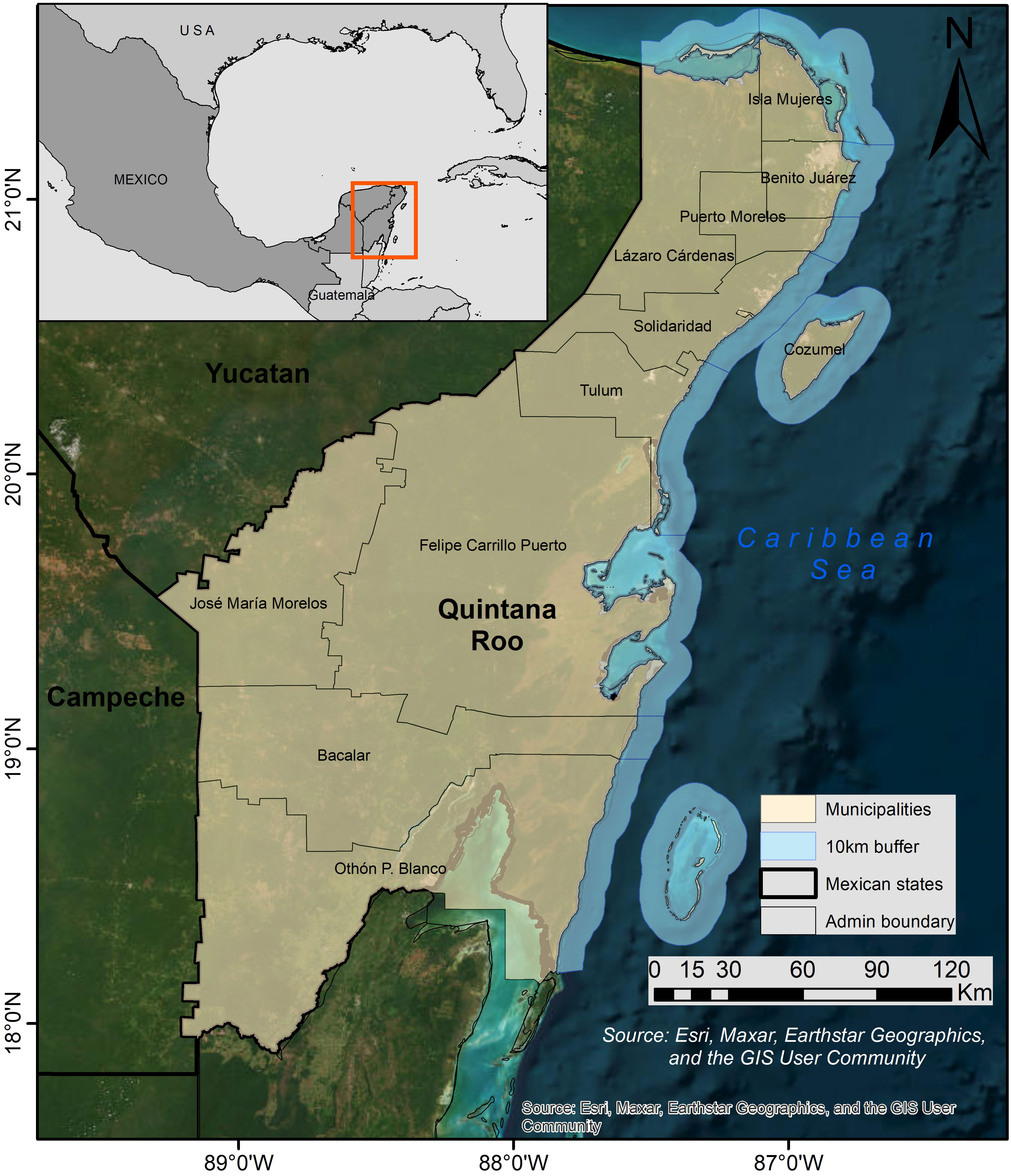
Figure 1 Study area: Mexican Caribbean Coast showing the coastal municipalities in Quintana Roo state and a 10km buffer area.
Sargassum usually arrives on the Mexican Caribbean coast from March to September/October (CONACYT, 2019). In recent years increases in the extent, frequency and duration of beaching events have been reported, causing complex ecological, economic, and social problems (Smetacek and Zingone, 2013; Milledge and Harvey, 2016; Van Tussenbroek et al., 2017; Chávez et al., 2020). For instance, in 2014 atypical volumes of sargassum were recorded by Schell et al. (2015) and reached the Mexican coast affecting many beaches. In 2015 the volume was 71,353 m3 (Rodríguez-Martínez et al., 2016) and in 2018 the volume was estimated to be three or four times greater than in 2015 (Rodríguez-Martínez et al., 2019; Wang et al., 2019; García-Sánchez et al., 2020). These massive influxes of sargassum on the Mexican Caribbean coast produce large-scale problems. It is essential to mitigate them to avoid serious, negative, irreversible socio-economic consequences and environmental damage. Our limited understanding of what controls sargassum movement in coastal waters and subsequent beaching, when and where it will arrive, means that the scarce resources available are being spent inefficiently, and ecosystems and livelihoods are being damaged unnecessarily (Chávez et al., 2020). Limited information about the quantities and status (fresh/decayed) of the sargassum also restrains exploitation of sargassum as a resource by downstream industries.
There are some existing projects and services (Table 1) which offer information on the location of sargassum based on EO data over large spatial or temporal scales and beach monitoring. It is unclear whether these can all be described as fully operational since many of them are still developing or run on a voluntary basis, however, they are all working to a certain degree.
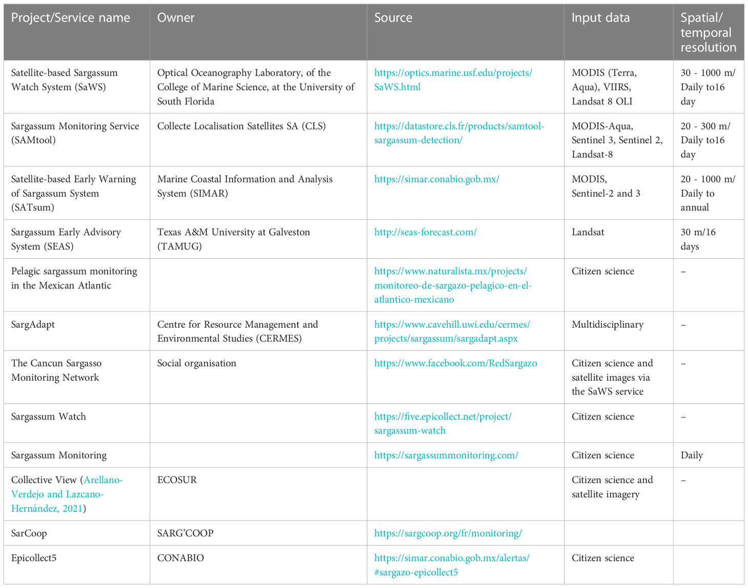
Table 1 Existent sargassum monitoring services.
From the activities described in Table 1 and those reported by Rosellón-Druker et al. (2022) there were at least 185 projects, initiatives or studies related to pelagic sargassum in Mexico from 2010 to 2021. It is evident that there is a significant demand for information on sargassum monitoring in Mexico and the Caribbean. The SASAMS project, funded by the UK Space Agency (UKSA) through their International Partnership Programme, was designed to advance research and enable practical solutions for the management of sargassum and provide timely information for local environmental and socio-economic decision-making. It focused on the sargassum journey, just prior to and after beaching. This project, therefore, filled a gap as it focused on a specific geographical region and technical specifications not yet adequately addressed by other services. The existing services tend to focus on the larger open sea and ocean basin scales and use sampling levels that can be addressed by medium and high spatial resolution EO data. They do not perform well in near shore conditions and many of their forecasts are likely to be inaccurate due to the complex hydrodynamics of shallow waters and detailed coastal configurations. SASAMS specifically aimed to address nearshore and onshore geographies which can only be mapped effectively by Very High spatial Resolution (VHR) EO data (< 5 m pixel sizes) with temporal resolution to enable potential daily revisit, such as PlanetScope (Planet Team, 2017). The tactical response to sargassum and the needs of local actors such as hoteliers, end users of sargassum and fishers can only be addressed by detailed mapping which captures local specificities, individual accumulations, and the impacts of structures such as harbours, breakwaters and booms on beaching and the build-up of sargassum.
To demonstrate the need for a sargassum monitoring system, understand the context of the sargassum influxes and the specific needs of stakeholders on the Mexican Caribbean coast for a monitoring system, a user requirements exercise was performed. This paper aims to describe this engagement, provide an overview of the resulting requirements and how this drove the development of a monitoring system to aid environmental management across the region.
3 Methodology
3.1 User requirements gathering
The success of a system is measured by the degree to which it fulfils the purpose for which it was designed (Gebauer, 2008). It is therefore essential to gather user requirements to define the purpose of the system. Gathering user requirements also heightens the engagement of stakeholders and identifies potential users, as well as recognizing the different needs for different users. Figure 2 shows the SASAMS methodology used for gathering the user requirements following Maguire and Bevan (2002).
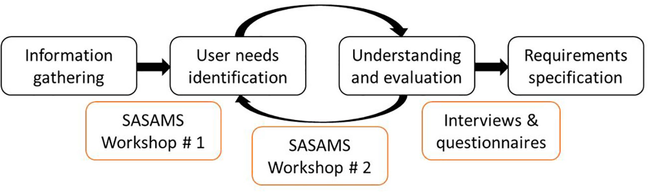
Figure 2 SASAMS user requirements methodology. Figure modified from Maguire and Bevan (2002).
3.1.1 Information gathering
To gather baseline information regarding the problem, the stakeholders and their relationships, a stakeholder analysis was developed to identify each stakeholder group, and their main roles, responsibilities and goals, in relation to the sargassum problem in Mexico and the Caribbean. Making use of in-country partners’ knowledge resulted in an extensive list of principal actors who were invited to the workshops. Gathering the information was an evolving process: it started before the first workshops, and continued during the subsequent workshops and then during follow-up interviews.
3.1.2 Identification of user needs
A diverse range of approaches were used to gather the information on user needs for the different groups. Three online workshops were held in September 2020 with different stakeholders and those interested in the use or impact of sargassum. The goal of these workshops was twofold. Firstly, to better understand and articulate the map of actors engaged with sargassum influxes in Mexico. Secondly, to gather and identify a set of user needs for monitoring sargassum and to help to understand how sargassum affects different sectors (i.e. society, tourism, fishing, etc.). The workshops also aimed to link the efforts that a wide range of stakeholders in Mexico are making towards the management and mitigation of the negative effects of the sargassum influxes. 48 representatives of 34 different institutions attended the workshops. They came from a broad range of societal stakeholders in Mexico: representatives of governmental departments and agencies (federal and local), non-profit organizations (NGOs), international organizations, private sector and academia. Twenty-three participants were based in the Caribbean region. The workshop facilitated dialogue among the participants about their needs and the ways to progress further with the knowledge obtained. The workshop activities were divided into three principal themes: 1) understanding the sargassum problem in the region and the impacts of sargassum influxes at different levels (economic, environmental and social); 2) understanding the challenges every stakeholder was facing to mitigate sargassum beaching and what had been/was being done, as well as discussions on the strengths and weaknesses of existing systems and current measures to face the problem, and 3) understanding the need for an effective monitoring system, focused on the spatial and temporal resolutions and information required. At the end of these workshops an initial set of user requirements for EO monitoring was compiled.
3.1.3 Understanding and requirement specifications
It was important to take the rather abstract requirements from the first workshop and demonstrate them through practical examples. Accordingly, a set of EO-based prototype systems were developed (Figure 3) addressing the needs identified. These prototypes were developed using different EO data, from coarse spatial resolution (Sentinel-3, 250 m pixels) to very high spatial resolution (SkySat, 50 cm pixels). The process of prototype design was iterative within the team. The prototypes were presented and discussed in a second set of workshops (two held in November 2020) with the aim of having a clear and realistic understanding of whether they were able to cover user needs. The details about the remote sensing and data management products are summarized in Table 2.
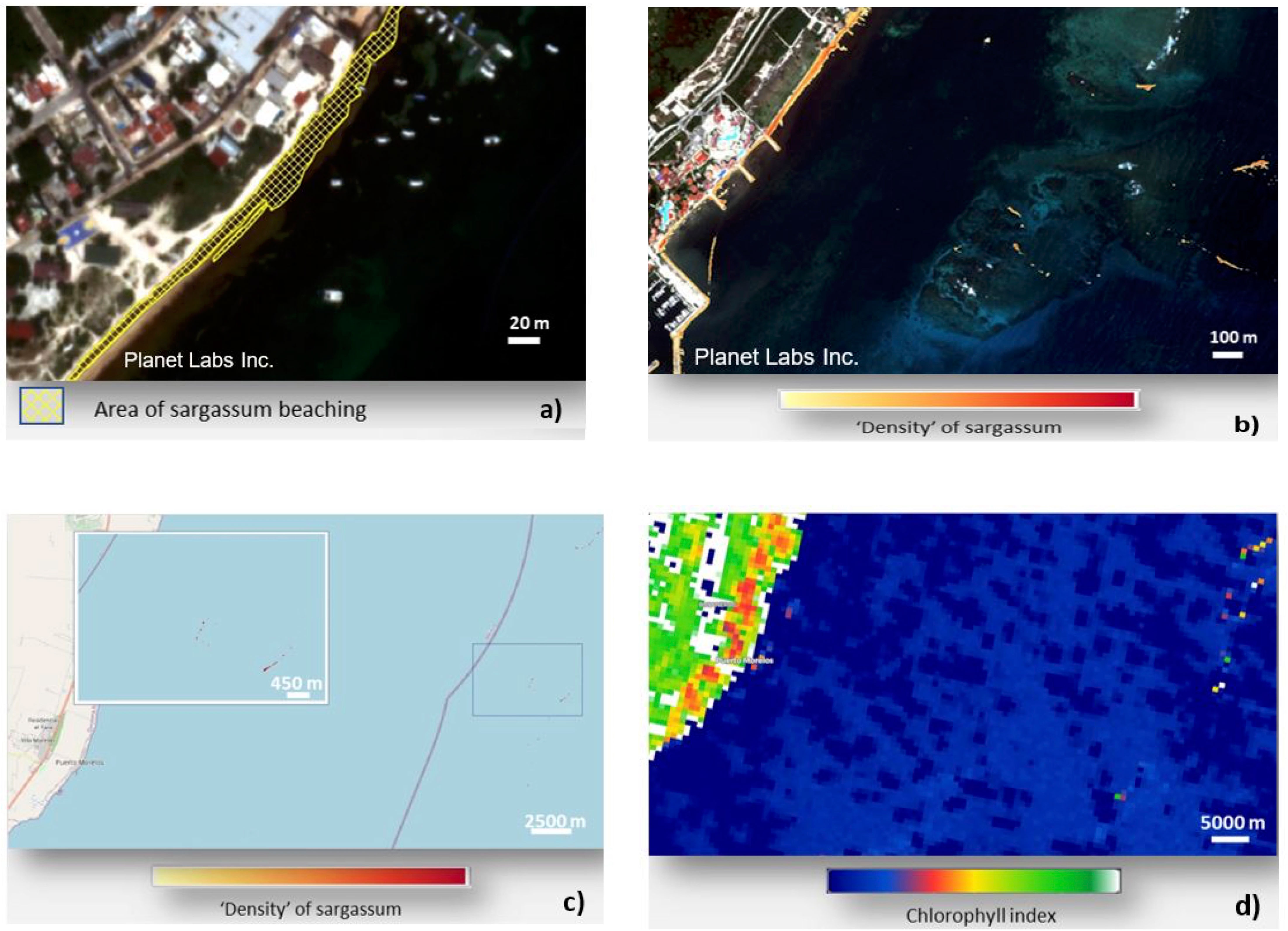
Figure 3 Monitoring system prototypes shown to workshop attendees. (A) SkySat based prototype; (B) Planet Scope based prototype; (C) Sentinel-2 based prototype; (D) Sentinel-3 based prototype. Satellite images: (A, B) © copyright Planet Labs Inc., (C) Basemapping: © copyright OpenStreetMap Contributors.
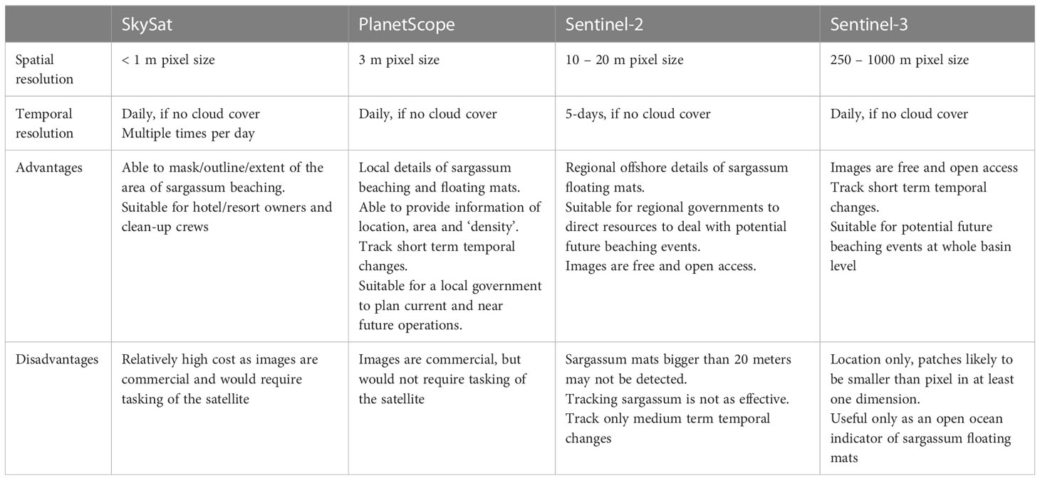
Table 2 Remote sensing and data management products.
3.1.4 Evaluation
This phase aimed to identify and understand the relationships between stakeholders and a range of other groups engaged with the sargassum influxes. Attendees were asked at the second set of workshops to revisit and prioritize their needs again and give feedback on how well these were covered in the prototypes; allowing the evaluation of both our understanding of how different actors and sectors prioritized their needs, and the initial set of prototype systems. For this, showing the prototype systems helped to clarify and focus user needs in terms of spatial and temporal resolution, but also brought a better understanding of how users would like the information to be displayed and how they would like to interact with it, the detail needed and the relevance this information for different sectors. Finally, questionnaires were sent to all participants to confirm that the stakeholders agreed with the needs identified.
4 Results
4.1 User requirements gathered
The workshops were well attended and participants represented the main actors and stakeholders interested or involved in the sargassum influxes. The 48 stakeholders attending the workshops, represented 34 different institutions including federal and local governmental agencies (15% and 17% respectively of the attendees), non-profit organizations (17%), international organizations (2%), private sector (8%), and academia (41%). There was agreement on the need for a sargassum early warning system, good management and environmentally friendly disposal practices, and the need for research and development into the use of sargassum, as well as best practices for its collection (on the beach and offshore).
To understand the needs of the users in terms of spatial resolution of EO-products, we used four different types of satellite imagery – SkySat, PlanetScope, Sentinel-2 and Sentinel-3 for creating the prototypes of the system (Figure 3). These were useful for comparison and helped us communicate with non EO experts. Most participants considered that very high spatial resolution (< 5 m pixel size) PlanetScope images would be the most suitable product, given the systematic observation and regular revisit periods. These products would be used mainly in managing the logistics of sargassum removal or collection, and as a source of information to build a more accurate monitoring system. The second most suitable product was Copernicus Sentinel-2 (10-20 m pixel size), with potential uses in the location and monitoring of sargassum further offshore. The third most suitable product was SkySat (<1 m pixel size), which provided the most detail, but at the highest cost and required tasking of acquisitions (target the satellite to a specific area of interest each time an image is required). The least suitable product was Sentinel-3 (250-1000 m pixel size) due to its coarse spatial resolution. However, participants recognized the potential use of Sentinel-3 for monitoring large sargassum mats far offshore and the capability of these images to monitor some parameters of water quality such as turbidity. Potential costs and benefits were discussed and the right balance of these was the reason why PlanetScope was the preferred data source. Even though people would have preferred the highest spatial resolution products (< 1 m spatial resolution) the constraints were appreciated. People mentioned the importance of these higher spatial resolution images for validating other products and the possibility of quantifying sargassum at ultrafine scales (i.e., centimeter scale pixels) from drones or ground-based observations.
The impacts of sargassum most mentioned during the workshops were: i) economic (on the tourism and fishing industries); ii) environmental (on corals, seagrasses and coastal ecosystems); and iii) social (health issues, potential aquifer contamination and income losses). It was agreed that massive influxes of sargassum on Mexican coasts and beaches can put public health at risk, stress marine and coastal ecosystems (e.g. alterations in reef systems due to the obstruction of light, eutrophication of water, toxic leachates, etc.) and threaten the tourism-based economy (e.g. beaches lose their scenic component diminishing the tourist experience). Workshop participants identified the need for data sharing and standardization to support advances in research and operational solutions. The principal needs identified and discussed were:
- The Presence/absence of sargassum at high spatial and temporal resolution. The identification of sargassum off-shore and on the beach at different locations and at different time intervals were the top priority for all stakeholders. This information is crucial for the informed management of sargassum, and its potential uses;
- The process of decay of sargassum. The state of the sargassum. Separating fresh (golden) sargassum from decaying or dried sargassum, is important for some industries, as they use only fresh sargassum in their production. Knowing the state of the sargassum could save money, improve the efficiency of these production processes and potentially increase the quantity of fresh sargassum collected;
- The movement and arrival times of sargassum. Tracking and prediction of the movement and landing of sargassum mats was seen as important for the tourism sector. Hotels and other recreational activities companies prioritize this need as this information would be beneficial for directing cleaning efforts efficiently, in a timely manner, and for directing tourists to the areas with less sargassum;
- The quantity of sargassum. Quantifying the biomass or volume of beached sargassum was an important need principally for researchers and mainstream industries (companies which have wider presence in different markets). The latter consider this would help in more efficient sargassum collection. Academics would like this information to understand patterns, cycles and trends of the sargassum arrivals;
- Access to Data and Applications. It was recognized that information about sargassum should be accessible to all sectors without the need for EO knowledge or expertise. Users remarked on the need to display the information in many formats, e.g., a website, a desktop application for computers and via mobile phones. The service should be able to send alerts to the users based on the occurrence of sargassum in a given Area of Interest (AOI).
Once the main needs were identified, participants were asked to prioritize using a MoSCoW prioritization approach. Most of the participants saw the presence or absence of sargassum as fundamental. Regarding the quantity of sargassum, 23 people saw it as required and 13 as recommended (Figure 4). In the case of the state of sargassum, 16 people agreed that the state of sargassum would be valuable. However, it is important to note that for private sector stakeholders and companies that use sargassum, the state of decay of the sargassum is a vital component of the system. For almost all participants tracking the movement of sargassum is central, as well as estimating its arrival time.
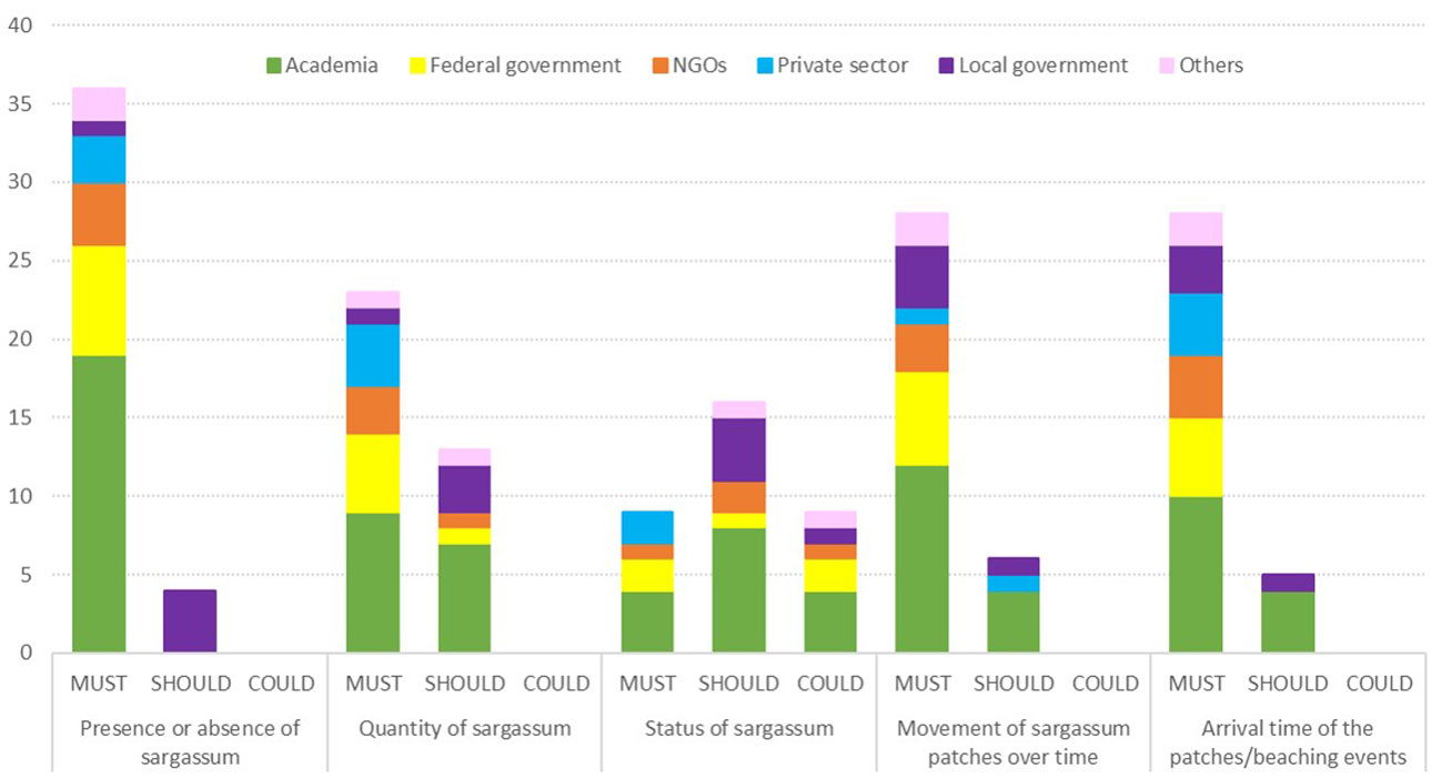
Figure 4 Priorities for sargassum monitoring identified by different stakeholder groups. The bar size represents the number of people with a given opinion. Modified from Foody et al. (2021).
To narrow down the rather extended range of options produced from the first set of workshops and understand the needs in terms of spatial and temporal scales of the monitoring system, more details were collected as shown in Figure 5. The results show that most participants chose 100 - 1000 meters as the minimum size feature mapped, followed by 10 - 100 meters. Participants were probably thinking specifically about the area that they needed information for, rather than the spatial resolution needed generally, and this is why these results seem different from those when the participants chose the best prototype.

Figure 5 Priorities for a sargassum monitoring system identified in a second set of workshops. The size of the circles are related to the number of people. Colour key: purple – local government; Blue – private sector; Yellow – federal government; Green – academia; Orange – NGOs; Pink – others.
Most of the participants were interested in having information in terms of area, rather than volume or mass. Regarding the sargassum decay process, most participants considered sargassum as fresh when it has been on the beach for less than 24 hours. The frequency with which most would like to receive information was daily and the most acceptable time between the passage of the satellite and the generation of the product was around 12 hours. For most participants, the monitoring system would primarily be used for research and decision-making. The first finding was expected, given that most of the participants were academics. Finally, stakeholders would prefer access to information via computer or an application.
The workshop participants acknowledged that the implementation of any sargassum monitoring system requires wide collaboration and engagement between all sectors and stakeholder groups. In the discussions it was reflected that currently there are insufficient links between scientific communities and decision-making.
The need for a technological solution that provides remote monitoring and early warnings of sargassum arrivals in the Caribbean Sea, such as that proposed by the SASAMS project, was acknowledged by a broad range of stakeholders. It is envisaged that such technology would be able to warn of the presence of sargassum on or near the coast and determine potential arrival sites, thereby assisting management and clearing logistics. Information is expected to be useful if available as an interactive web platform with periodic reports and potentially alerts automatically generated.
Support from SASAMS would be beneficial to stakeholders involved in sargassum management activities, allowing them to make more efficient use of their resources. This would include federal and regional government departments, some environmental NGOs and, in the private sector, hotels. Preserving the beauty of the Mexican Caribbean coast (important for tourism) through sea-borne control measures, or through more efficient and effective sargassum removal from beaches would benefit the tourist industry and protect jobs directly and indirectly associated with it. The fishing fleet would be able to avoid areas and times when sargassum is most prevalent. Finally, industries that use sargassum as a raw material would enjoy reliable, fresh sargassum supplies.
From the user requirements exercise, the basis of a prototype system that would be used for identifying the location of sargassum at sea and on beaches was defined. This would improve logistics for collection close to the coast, and on the coast, and/or the positioning of barriers at sea. In the short term, these measures would help to reduce the quantity of sargassum reaching beaches in peak years and thereby reduce the negative economic impacts on the tourism industry and on coastal marine ecology. In the medium term, the ability of the system to predict the location, quantity and condition of sargassum at sea is hoped would encourage academic and private sector research on potential commercial exploitation of sargassum. This, in turn could provide a longer-term, sustainable solution to the negative impact of sargassum on the economy of Mexico and other affected countries.
4.2 Pilot monitoring system
Although more research is required to understand the mechanisms for decision-making and coordination of the management of the sargassum influxes, our user requirements exercise helped to inform the design of a pre-operational service based on SASAMS. A prototype system called SargAssure has been developed with additional UKSA funding through their Underpinning Technology Development Programme. The service is running in pre-operational mode for selected users and early adopters who are providing feedback on its functionality and products. SargAssure focuses on the main need of users: mapping the presence of sargassum but can be extended to include the other needs. A web application (Figure 6) allows users to define an area of interest (AOI), for example a stretch of beach and the adjacent nearshore environment. Once the AOI is established, the system automatically searches until a new image acquisition from the PlanetScope Super Dove satellites becomes available. This is then downloaded and processed to produce a sargassum presence/absence product with an alert being emailed to the user when the results are available to view in the web application. On receiving the alert, the user can then return to the web application to see results and reports generated, evaluate the situation and decide whether action needs to be taken.
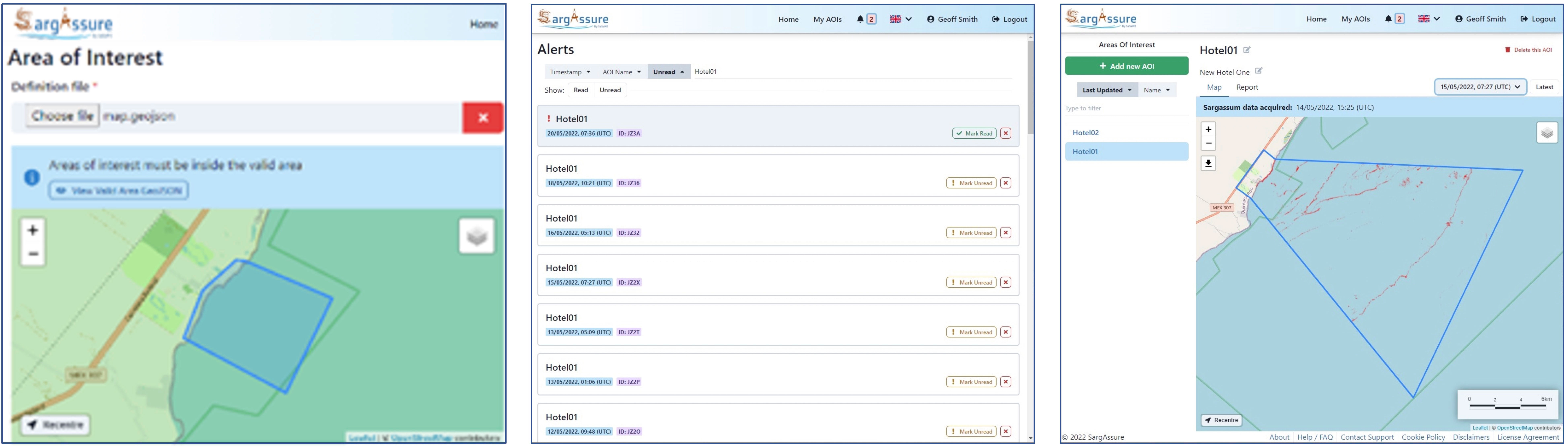
Figure 6 SargAssure interface.
5 Discussion and conclusions
In recent years, the beaching of sargassum has become a major environmental and societal problem (Huffard et al., 2014; Ody et al., 2019; Oviatt et al., 2019). Given that sargassum influxes were a key priority topic for government research in Mexico, this project is aligned with a critical issue at a time when urgent support is needed.
The study places central focus on socio-economic benefits, as it was estimated by the Mexican Ministry of Tourism that more than 1,000,000 tonnes of sargassum were removed from the Quintana Roo coastal region in 2019. The government has been investing ever-more money in the work force to deal with this problem, in sargassum collection ships, machinery, etc. that have not been used effectively as reliable tactical information on the problem was lacking. Investments have increased from $9 million US dollars in 2013 to $17 million US dollars in 2019, and $29 million US dollars in 2022. An operational EO-based monitoring service will allow the appropriate authorities to plan and direct resources where they are most needed. In the longer term, a better understanding of sargassum dynamics will enable authorities to determine the impacts on socio-economic systems such as fisheries and health, and to develop strategies to minimizing these impacts.
The environmental and socio-economic benefits outlined above, coupled with the threats to ecosystem health and human well-being stemming from the mismanagement of sargassum, indicate that the proposed system will have a positive impact across a number of SDGs, contributing primarily to SDG 13 (Strengthen resilience and adaptive capacity to climate related disasters) and SDG 14 (Reduction in negative effects of sargassum on environment and ecology). By monitoring sargassum and improving early warning capabilities, this project has the potential to improve our understanding of sargassum ecology and dynamics, boost the resilience of local tourism and fishing industries against the adverse effects of sargassum influxes and to safeguard increasingly fragile ecosystems and the species inhabiting them.
Action on sargassum arriving to the coast, whether short-term beach clearance, capture at sea, or long-term scientific research, requires further investigation. The Mexican government has provided aid packages in response to sargassum impacts relative to the severity of the problem in particular years, but this has not been enough to fully mitigate the economic and social impacts of the sargassum influxes. The Covid-19 pandemic and the accompanying economic recession has exacerbated the pressure on the Mexican government to invest in combatting the problems caused by the sargassum influxes.
Monitoring sargassum at higher spatial and temporal resolutions represents a significant change in dealing with the problems caused by the excessive sargassum and supports the best environmental management practices for its removal. Earth observation (EO) data can be used to provide timely and accurate information on sargassum influxes, allowing for effective decision-making and resource allocation. This is particularly important in the case of sargassum, as the dynamics of the algae can change rapidly and unpredictably. High-resolution EO data can also help to further identify the underlying processes that drive sargassum influxes. By leveraging the power of EO data, the proposed monitoring system has the potential to provide a comprehensive and holistic understanding of sargassum dynamics, ultimately contributing to more effective management of this growing environmental problem.
Even though the study area is in Mexico, increasingly large and frequent sargassum beachings have affected over 20 Caribbean countries, as well as others in West Africa and elsewhere in the tropics (Ody et al., 2019; Oviatt et al., 2019; Johns et al., 2020). EO-based services such as that outlined here have potential to impact across the entire region and the globe.
Data availability statement
The original contributions presented in the study are included in the article/supplementary material. Further inquiries can be directed to the corresponding author.
Author contributions
BB-B: Conceptualization, original idea, data collection, formal analysis, methodology, project administration, writing-original draft, editing; GF: supervision, conceptualization, funding, project administration, writing-review & editing; SM: conceptualization, data collection, formal analysis, writing-original draft; GS: conceptualization, formal analysis, writing-original draft, methodology and technical support. SS: conceptualization, funding acquisition, technical support, reviewing final draft. DB: technical support, project administration, reviewing final draft SC-E: conceptualization, data collection; RR: technical support, data collection, data analysis; PL-R: conceptualization, technical support, data collection, reviewing final draft; AM: conceptualization, technical support, data collection, reviewing final draft; SP-V: technical support, data collection; HC-A: technical support, data collection; OS: technical support, data collection; PG: methodology, technical support, reviewing and editing final draft; JC: methodology, software; RS: conceptualization, technical support, reviewing and editing final draft; BV: conceptualization, technical support, reviewing and editing final draft; EE-M: data collection. All authors contributed to the article and approved the submitted version.
Funding
SAtellite SArgassum Monitoring System (SASAMS) - developing a real-time monitoring service for Mexico’s Caribbean Coast funded through Call 3 of the UK Space Agency’s International Partnership Programme (IPP); SargAssure – Providing reliable actionable near-real-time information to the sargassum downstream industry sector (UKSAG21_0028) funded through the UK Space Agency’s International Partnership Programme Technology Development Programme (Pin2D); CONACYT-SENER-Sustentabilidad Energética project: “Centro Mexicano de Innovación on Energía del Océano (CEMIE Océano)”. FSE-2014-06-249795.
Acknowledgments
We are grateful to the colleagues who have helped us during the project and in the workshops: Georgina Dean, Jacqui Clay, Martin Wright, Noah Poulson, Sarah Newman, Karla Hernández-Aguilar, Jahzeel Aguilera Lara and many others.
Conflict of interest
Author PG is/was employed by Hybrid Geospatial Ltd. Author GS is/was employed by Specto Natura Limited. The remaining authors declare that the research was conducted in the absence of any commercial or financial relationships that could be construed as a potential conflict of interest.
Publisher’s note
All claims expressed in this article are solely those of the authors and do not necessarily represent those of their affiliated organizations, or those of the publisher, the editors and the reviewers. Any product that may be evaluated in this article, or claim that may be made by its manufacturer, is not guaranteed or endorsed by the publisher.
References
Arellano-Verdejo J., Lazcano-Hernández H. E. (2021). Collective view: mapping sargassum distribution along beaches. PeerJ Comput. Sci. 7, e528. doi: 10.7717/peerj-cs.528
Azcorra-May K. J., Olguin-Maciel E., Domínguez-Maldonado J., Toledano-Thompson T., Leal-Bautista R. M., Alzate-Gaviria L., et al. (2022). Sargassum biorefineries: potential opportunities towards shifting from wastes to products. Biomass Conv. Bioref, 1–9. doi: 10.1007/s13399-022-02407-2
Casas-Beltrán D. A., Gallaher C. M., Hernández Yac E., Febles Moreno K., Voglesonger K., Leal-Bautista R. M., et al. (2020). Seaweed invasion! temporal changes in beach conditions lead to increasing cenote usage and contamination in the Riviera Maya. Sustainability 12 (6), 2474. doi: 10.3390/su12062474
Chávez V., Uribe-Martínez A., Cuevas E., Rodríguez-Martínez R. E., van Tussenbroek B. I., Francisco V., et al. (2020). Massive influx of pelagic sargassum spp. on the coasts of the Mexican Caribbean 2014–2020: challenges and opportunities. Water 12 (10), 2908. doi: 10.3390/w12102908
CONACYT (2019) Agenda de ciencia, tecnología e innovación para la atención, adaptación y mitigación del arribo de sargazo pelágico al caribe mexicano. Available at: https://conacyt.mx/sargazo/index.php/agenda-de-ciencia-y-tecnologia (Accessed January 30, 2022).
Foody G. M., Caballero-Aragón H., de la Barreda-Bautista B., Boyd D. S., Estrada S. C., Lopez P., et al. (2021). “Developing a system to map and monitor beached sargassum on the Caribbean coast of Mexico,” in 2021 IEEE International Geoscience and Remote Sensing Symposium IGARSS, Brussels, Belgium. 2432–2435), 2432-2435. doi: 10.1109/IGARSS47720.2021.9553052
García-Sánchez M., Graham C., Vera E., Escalante-Mancera E., Álvarez-Filip L., Van Tussenbroek B. I. (2020). Temporal changes in the composition and biomass of beached pelagic sargassum species in the Mexican Caribbean. Aquat. Bot. 167, 103275. doi: 10.1016/j.aquabot.2020.103275
Gebauer J. (2008). User requirements of mobile technology: a summary of research results. Inf. Knowledge Syst. Manage. 7 (1-2), 101–119.
Gower J., King S. (2008). Satellite images show the movement of floating sargassum in the gulf of Mexico and Atlantic ocean. Nat. Prec 1-1. doi: 10.1038/npre.2008.1894.1
Gower J. F., King S. A. (2011). Distribution of floating sargassum in the gulf of Mexico and the Atlantic ocean mapped using MERIS. Int. J. Remote Sens. 32 (7), 1917–1929. doi: 10.1080/01431161003639660
Hernández W. J., Morell J. M., Armstrong R. A. (2020). High-resolution satellite imagery to assess sargassum inundation impacts to coastal areas. bioRxiv 13 (1), 24–34. doi: 10.1080/2150704X.2021.1981558
Hinds C., Oxenford H., Cumberbatch J., Fardin F., Doyle E., Cashman A. (2016). Golden tides: management best practices for influxes of sargassum in the Caribbean with a focus on clean-up. Barbados (Cave Hill Campus: Centre for Resource Management and Environmental Studies (CERMES), The University of the West Indies), 17. doi: 10.25607/OBP-786
Hu C. (2009). A novel ocean color index to detect floating algae in the global oceans. Remote Sens. Environ. 113 (10), 2118–2129. doi: 10.1016/j.rse.2009.05.012
Hu C., Feng L., Hardy R. F., Hochberg E. J. (2015). Spectral and spatial requirements of remote measurements of pelagic sargassum macroalgae. Remote Sens. Environ. 167, 229–246. doi: 10.1016/j.rse.2015.05.022
Huffard C. L., Von Thun S., Sherman A. D., Sealey K., Smith K. L. (2014). Pelagic sargassum community change over a 40-year period: temporal and spatial variability. Mar. Biol. 161 (12), 2735–2751. doi: 10.1007/s00227-014-2539-y
Johns E. M., Lumpkin R., Putman N. F., Smith R. H., Muller-Karger F. E., Rueda-Roa D. T., et al. (2020). The establishment of a pelagic sargassum population in the tropical Atlantic: biological consequences of a basin-scale long distance dispersal event. Prog. Oceanogr. 182, 102269. doi: 10.1016/j.pocean.2020.102269
Laffoley D. d’A, Roe H. S. J., Angel M. V., Ardron A., Bates B., Boyd B., et al. (2011). The protection and management of the Sargasso Sea: The golden floating rainforest of the Atlantic Ocean. Marine Science Faculty Publications, 633. Available at: https://digitalcommons.usf.edu/msc_facpub/633.
Lapointe B. E., Brewton R. A., Herren L. W., Wang M., Hu C., Mcgillicuddy D. J., et al. (2021). Nutrient content and stoichiometry of pelagic sargassum reflects increasing nitrogen availability in the Atlantic basin. Nat. Commun. 12 (1), 1–10. doi: 10.1038/s41467-021-23135-7
López-Miranda J. L., Molina G. A., Esparza R., González-Reyna M. A., Silva R., Estévez M. (2022). Ecofriendly and sustainable sargassum spp.-based system for the removal of highly used drugs during the COVID-19 pandemic. Arabian J. Chem. 15 (10), 104169. doi: 10.1016/j.arabjc.2022.104169
Lopresto C. G., Paletta R., Filippelli P., Galluccio L., de la Rosa C., Amaro E., et al. (2022). Sargassum invasion in the Caribbean: an opportunity for coastal communities to produce bioenergy based on biorefinery–an overview. Waste Biomass Valorization 13, 2769–2793. doi: 10.1007/s12649-021-01669-7
Maguire M., Bevan N. (2002). “User requirements analysis,” in IFIP world computer congress (Boston, MA: Springer), 133–148.
Maréchal J. P., Hellio C., Hu C. (2017). A simple, fast, and reliable method to predict sargassum washing ashore in the lesser antilles. Remote Sens. Applications: Soc. Environ. 5, 54–63. doi: 10.1016/j.rsase.2017.01.001
Marsh R., Oxenford H. A., Cox S.-A. L., Johnson DR and Bellamy J. (2022). Forecasting seasonal sargassum events across the tropical Atlantic: overview and challenges. Front. Mar. Sci. 9. doi: 10.3389/fmars.2022.914501
Marx U. C., Roles J., Hankamer B. (2021). Sargassum blooms in the Atlantic ocean – from burden to asset. Algal Res. 54, 102188. doi: 10.1016/j.algal.2021.102188
Milledge J. J., Harvey P. J. (2016). Golden tides: problem or golden opportunity? the valorisation of sargassum from beach inundations. J. Mar. Sci. Eng. 4 (3), 60–79. doi: 10.3390/jmse4030060
Miranda J. L. L., Celis L. B., Estévez M., Chávez V., Van Tussenbroek B. I., Uribe-Martínez A., et al. (2021). Commercial potential of pelagic sargassum spp. in Mexico. Front. Mar. Sci. 8. doi: 10.3389/fmars.2021.768470
Miron P., Olascoaga M. J., Beron-Vera F. J., Putman N. F., Triñanes J., Lumpkin R., et al. (2020). Clustering of marine-debris- and sargassum-like drifters explained by inertial particle dynamics. Geophysical Res. Lett. 47, e2020GL089874. doi: 10.1029/2020GL089874
Ody A., Thibaut T., Berline L., Changeux T., André J. M., Chevalier C., et al. (2019). From In situ to satellite observations of pelagic sargassum distribution and aggregation in the tropical north Atlantic ocean. PLoS One 14 (9), e0222584. doi: 10.1371/journal.pone.0222584
OECD (2020). “Mexico,” in OECD tourism trends and policies 2020 (Paris: OECD Publishing). (accessed on 27 April 2022 doi: 10.1787/525e83e3-en
Oviatt C. A., Huizenga K., Rogers C. S., Miller W. J. (2019). What nutrient sources support anomalous growth and the recent sargassum mass stranding on Caribbean beaches? a review. Mar. pollut. Bull. 145, 517–525. doi: 10.1016/j.marpolbul.2019.06.049
Oxenford H. A., Cox S. A., Van Tussenbroek B. I., Desrochers A. (2021). Challenges of turning the sargassum crisis into gold: current constraints and implications for the Caribbean. Phycology 1 (1), 27–48. doi: 10.3390/phycology1010003
Oyesiku O. O., Egunyomi A. (2014). Identification and chemical studies of pelagic masses of sargassum natans (Linnaeus) gaillon and s. fluitans (Borgessen) borgesen (brown algae), found offshore in ondo state, Nigeria. Afr. J. Biotechnol. 13 (10), 1188–1193. doi: 10.5897/AJB2013.12335
Planet Team (2017). “Planet application program interface,” in In space for life on earth (San Francisco, CA: Planet Labs PBC). Available at: https://api.planet.com.
Portal Ambiental (2019) Sargazo ha impactado negativamente en el turismo del caribe mexicano. Available at: https://www.portalambiental.com.mx/impacto-ambiental/20190613/sargazo-ha-impactado-negativamente-en-el-turismo-del-caribe-mexicano.
Rodríguez-Martínez R. E., Medina-Valmaseda A. E., Blanchon P., Monroy-Velázquez L. V., Almazán-Becerril A., Delgado-Pech B., et al. (2019). Faunal mortality associated with massive beaching and decomposition of pelagic sargassum. Mar. pollut. Bull. 146, 201–205. doi: 10.1016/j.marpolbul.2019.06.015
Rodríguez-Martínez R. E., Van Tussenbroek B., Jordán-Dahlgren E. (2016). “Afluencia masiva de sargazo pelágico a la costa del caribe mexicano (2014–2015),” in Florecimientos algales nocivos en méxico. Eds. García-Mendoza E., Quijano-Scheggia S. I., Olivos-Ortiz A., Núñez-Vázquez E. J. (Mexico: CICESE: Ensenada, BC), 352–365.
Rosellón-Druker J., Calixto-Pérez E., Escobar-Briones E., González-Cano J., Masiá-Nebot L., Córdova-Tapia F. (2022). A review of a decade of local projects, studies and initiatives of atypical influxes of pelagic sargassum on Mexican Caribbean coasts. Phycology 2 (3), 254–279. doi: 10.3390/phycology2030014
Ruiz-Ramírez J. D., Euán-Ávila J. I., Rivera-Monroy V. H. (2019). Vulnerability of coastal resort cities to mean sea level rise in the Mexican Caribbean. Coast. Manage. 47 (1), 23–43. doi: 10.1080/08920753.2019.1525260
Rutten J., Arriaga J., Montoya L. D., Mariño-Tapia I. J., Escalante-Mancera E., Mendoza E. T., et al. (2021). Beaching and natural removal dynamics of pelagic sargassum in a fringing-reef lagoon. J. Geophysical Research: Oceans 126 (11), e2021JC017636. doi: 10.1029/2021JC017636
Schell J. M., Goodwin D. S., Siuda A. N. S. (2015). Recent sargassum inundation events in the Caribbean: Shipboard observations reveal dominance of a previously rare form. Oceanography 28 (3), 8–11. Available at: http://www.jstor.org/stable/24861895.
Smetacek V., Zingone A. (2013). Green and golden seaweed tides on the rise. Nature 504 (7478), 84–88. doi: 10.1038/nature12860
Van Tussenbroek B. I., Arana H. A. H., Rodríguez-Martínez R. E., Espinoza-Avalos J., Canizales-Flores H. M., González-Godoy C. E., et al. (2017). Severe impacts of brown tides caused by sargassum spp. on near-shore Caribbean seagrass communities. Mar. pollut. Bull. 122 (1-2), 272–281. doi: 10.1016/j.marpolbul.2017.06.057
Wang M., Hu C. (2021). Satellite remote sensing of pelagic sargassum macroalgae: the power of high resolution and deep learning. Remote Sens. Environ. 264, 112631. doi: 10.1016/j.rse.2021.112631
Wang M., Hu C., Barnes B. B., Mitchum G., Lapointe B., Montoya J. P. (2019). The great Atlantic sargassum belt. Science 365 (6448), 83–87. doi: 10.1126/science.aaw7912
Zanolli L. (2019). “Why seaweed is strangling Mexican tourism, and how science could help,” in MIT Technology review. Available at: https://www.technologyreview.com/2019/04/24/65842/why-seaweed-is-strangling-mexican-tourism-and-how-science-could-help/.
Keywords: pelagic sargassum, monitoring, earth observation, Mexico, Caribbean, sargassum management, sargassum use, sargassum solutions
Citation: de la Barreda-Bautista B, Metcalfe SE, Smith G, Sjögersten S, Boyd DS, Cerdeira-Estrada S, López-Ramírez P, Magaldi A, Ressl R, Perera-Valderrama S, Caballero-Aragón H, Siordia OS, Couldridge J, Gray P, Silva R, Van Tussenbroek BI, Escalante‐Mancera E and Foody G (2023) Monitoring holopelagic Sargassum spp. along the Mexican Caribbean coast: understanding and addressing user requirements for satellite remote sensing. Front. Mar. Sci. 10:1166000. doi: 10.3389/fmars.2023.1166000
Received: 14 February 2023; Accepted: 08 May 2023;
Published: 24 May 2023.
Edited by:
Wei-Bo Chen, National Science and Technology Center for Disaster Reduction (NCDR), TaiwanReviewed by:
Muta Zakaria, Putra Malaysia University, MalaysiaAntoine De Ramon N’Yeurt, University of the South Pacific, Fiji
Copyright © 2023 de la Barreda-Bautista, Metcalfe, Smith, Sjögersten, Boyd, Cerdeira-Estrada, López-Ramírez, Magaldi, Ressl, Perera-Valderrama, Caballero-Aragón, Siordia, Couldridge, Gray, Silva, Van Tussenbroek, Escalante‐Mancera and Foody. This is an open-access article distributed under the terms of the Creative Commons Attribution License (CC BY). The use, distribution or reproduction in other forums is permitted, provided the original author(s) and the copyright owner(s) are credited and that the original publication in this journal is cited, in accordance with accepted academic practice. No use, distribution or reproduction is permitted which does not comply with these terms.
*Correspondence: Betsabé de la Barreda-Bautista, YmV0c2FiZS5kZWxhYmFycmVkYUBub3R0aW5naGFtLmFjLnVr