 Jingfang Lu1
 Yibo Zhang
 Honghua Shi
 Xianqing Lv
- 1Frontier Science Center for Deep Ocean Multispheres and Earth System (FDOMES) and Physical Oceanography Laboratory, Ocean University of China, Qingdao, China
- 2First Institute of Oceanography, Ministry of Natural Resources, Qingdao, China
- 3Laoshan Laboratory, Qingdao, China
Since 2000, coastal reclamation projects have been implemented in the Guangxi Beibu Gulf to alleviate the shortage of coastal land resources. As a result, the reclamation area has increased significantly. In this study, based on the Landsat program, we tracked coastal reclamation in the coastal waters of Guangxi in the 21st century. An indicator system was proposed to assess the driving forces of reclamation synthetically. Our results showed that 98.6 km2 of coastal waters of the Guangxi Beibu Gulf was reclaimed from 1997 to 2017, in which three regions underwent great changes: Fangcheng Bay, Tieshan Bay, and Qiznhou Bay. Furthermore, spatio-temporal changes of reclamation were affected by the combination of population growth, economic development, and marine industry development in coastal cities. These results provide an important historical reference for tracking the human development processes of the Guangxi Beibu Gulf, and also offer some suggestions for the rational allocation of reclamation resources.
Graphical Abstract
1 Introduction
Coastal reclamation, one of humankind’s most radical modifications of the ocean, is motivated by a growing demand for land resources. Multiple driving factors, including coastal and foreshore defenses (Herbeck and Flitner, 2019), residential and commercial developments (Chee et al., 2023), and growing coastal populations and infrastructure needs (Bisaro et al., 2020), such as airports or ports (Suzuki, 2003; Wang et al., 2014), have resulted in large scales of land reclamation. For example, Chee et al., 2023, demonstrated that the need to develop and modernize was the main driver cited as reasons to reclaim Malaysian coastlines. Suzuki, 2003, showed that in Japan the topography and the requirement for residential, commercial, and industrial development contributed to the need to expand into the sea. Further, port expansions are also a driver for coastal reclamation (Muller et al., 2020; Lin et al., 2021), In addition, the rapid expansion of the coastal economy and accelerated coastal population growth in the Bohai Sea have caused a sharp increase in land reclamation (Temmerman et al., 2013). Moreover, many coastal countries, including America (Kennish, 2001), China (Ma et al., 2014), Singapore (Powell, 2021), and Malaysia (Chee et al., 2023), have conducted coastal reclamation for urban development. Therefore, the drivers of land reclamation are often multitudinous, so accurate evaluation of these factors is important for marine management.
According to the world’s first map of the physical footprint of marine construction, Bugnot et al. (2020) noted that coastal reclamation was continuing to spread and taking up more and more of the global ocean area in 2020; China is the economic zone with the most oceanic construction (accounting for 40% of the global ocean construction) since its reform and opening up in the early 1980s. Studies showed that the majority of China’s reclamation was concentrated in the Bohai Sea, Yangtze Estuary Delta, and Pearl River Delta (Tian et al., 2016). However, reclamation activities also increased significantly in the Guangxi Beibu Gulf, where a large amount of land was needed for urban construction, further harbors, farmlands, and aquaculture ponds within the development of the Beibu Gulf Economic Zone (Sun et al., 2020; Zhao et al., 2021; Lyu et al., 2022). The drivers of land reclamation are often multitudinous, so accurate evaluation of these factors is important for marine management.
The Guangxi Beibu Gulf is located in the northwestern part of the South China Sea. It is bounded by the Leizhou Peninsula and Hainan Island to the east, the Guangxi Zhuang Autonomous Region to the north, and Vietnam to the west. It is connected to the South China Sea via the Qiongzhou Strait. (Lao et al., 2021). Compared with other coastal areas in China, the development and exploitation of marine resources in the Beibu Gulf started relatively later due to the particularities of its geographical location. However, after years of development and construction, the Guangxi Beibu Gulf Economic Zone has become a multi-regional cooperation center and the leader of Guangxi’s opening-up policies, and been incorporated into China’s national development strategy (Han et al., 2018). For the past two decades, the Guangxi Beibu Gulf has experienced extreme coastal reclamation, which has resulted in the significant loss of coastal wetlands and degradation of the natural shoreline; this poses significant challenges to its ecological environment and the ecosystem service functions, especially the widely distributed and typical coastal wetlands with mangroves and seagrass beds within the coastal waters of Guangxi in the Beibu Gulf (Sun et al., 2020).
Previous studies on the reclamation of the Guangxi Beibu Gulf have mainly focused on coastline changes (Yu et al., 2021), hydrodynamic changes (Wang et al., 2021), and pollutant discharge (Lyu et al., 2022). At present, there have been no attempts to derive a consecutive-yearly estimate of the extent of reclamation and its driving factors. Some studies have already discussed the relationship between reclamation and socio-economic factors. For example, Tian et al. (2016) analyzed and quantified the spatio-temporal variation of reclamation in China, and found that high-intensity coastal reclamation was mainly driven by the booming economy, especially after 2000, which was associated with urbanization and industrial development in China’s coastal region. Meng et al. (2017) found that marine industrial development and industrial wastewater discharge had a positive correlation with sea reclamation. Hence, the most complete assessments of driving factors on the reclamation should consider multiple statistical data, such as gross economic product, human population density, and marine industry development.
More recent remote sensing images have provided a unique opportunity to investigate the distribution of reclamation activities in the Guangxi Beibu Gulf coast from 1997 to 2017. We accurately measured the position of reclamations derived from two remote sensing images (Path/Row: 125/045,124/045), a composite ground truth that ideally aggregates images from the same month taken by Landsat (Figure 1A). Subsequently we provide a new evaluation indicator system for the assessment of the driving force factors of reclamation. The hypothesis that GDP and population growth have significant effects on reclamation in coastal cities was supported in our study. The general objective of this paper was to comprehensively evaluate the impacts of driving forces on reclamation in near-coastal waters of the Guangxi Beibu Gulf. The specific objectives were: 1) to draw a diagram of the spatio-temporal changes of near-coastal reclamation in coastal waters; 2) to explain the initiation mechanisms of reclamation intensity and its changes from the factors of population, economy, urbanization, and industrialization. The results of this study will provide some references for the development and protection of the Guangxi Beibu Gulf coast.

Figure 1 Map showing the location of the study area (A). The main bays and two reclamation projects (B) are noted on Landsat images (captured on 22 Oct 2017).
2 Materials and methods
2.1 Studied area
The Guangxi Beibu Gulf is located in the northwestern part of the South China Sea and bounded by the Leizhou Peninsula and Hainan Island on the east (Figure 1). The Beibu Gulf is an important newly developing industry and port area. It has some bays, including Fangcheng Bay, Qinzhou Bay, Lianzhou Bay, and Tieshan Bay (Zhu et al., 2022). The main types of natural coastlines include coral reefs, intertidal silt, and mangrove swamps, which are mostly found on the west coast of the Guangxi Beibu Gulf, and about 80% of rock coasts are on the east coast; the rest are sand and silt coasts (Sun et al., 2020). With the increase in development intensity, the natural coasts of the Beibu Gulf are being damaged at an alarming rate (Zhao et al., 2021).
In recent years, reclamation activities have increased in the Beibu Gulf due to its special location and unique natural resources. Consequently, the land-use types have been remarkably changed. For example, the Nanliu River estuary delta has been used for aquaculture activities, and Qinzhou Harbor (32.5 km2) was reclaimed for residential and commercial developments in Qinzhou City (Lyu et al., 2022). This study involved three cities, including Fangchenggang City, Qinzhou City, and Beihai City in Guangxi Province, China, with a total regional GDP of 103.5 billion RMB and a total population of 24.6 million (Guangxi Statistical Yearbook, 1995–2015).
2.2 Data resource
The data used in this study were mainly from the following four resources: remote sensing image data from the geospatial data cloud (http://www.gscloud.cn) (Table 1); vector data (including the length of artificial coastlines, natural coastlines, reclamation areas, and their utilization types) extracted from the Geographic Information System (Versions: ArcGIS. 10.1); statistical data from the China Marine Statistical Yearbook (1997-2018) and the Statistical Yearbooks of Guangxi Zhuang Autonomous Region (1997-2018); Google Earth Pro 7.3 data as a geographical reference for identifying and correcting marine constructions such as ports, wharves, and dams.

Table 1 List of land satellite image data of the Guangxi Beibu Gulf.
In this study, we present new interpretation signs of reclamation based on remote sensing images and the knowledge of the morphological features, vegetation, and coastal engineering characteristics (shape, size, color, and texture). Herein, the technological framework is shown in Figure 2. The goals are: 1) to identify the extent of existing coastal reclamation by establishing interpretation signs in the Guangxi Beibu Gulf; 2) to reveal the characteristics of the spatio-temporal changes of the coastline and reclamation; and 3) to identify the driving forces of reclamation.
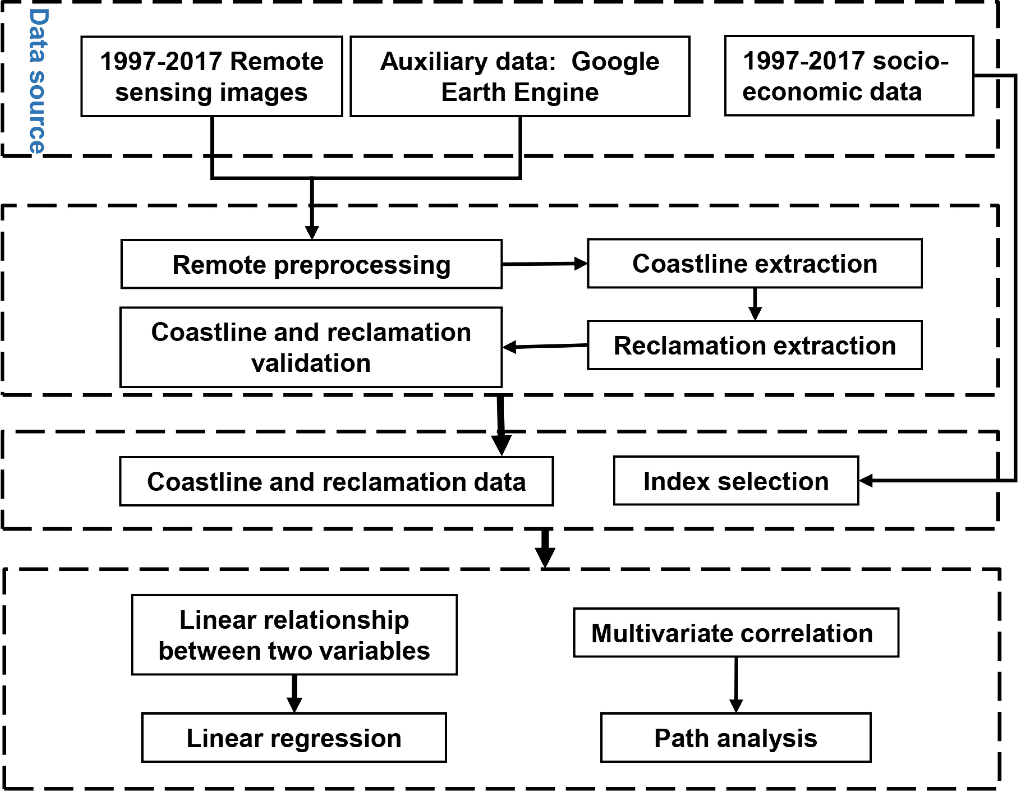
Figure 2 Method flow chart of the study.
2.3 Remote sensing image processing
Twenty-one remote sensing images of the Guangxi Beibu Gulf reclamation area were used in this study. Table 1 shows detailed information on the land satellite image data. The radiometric calibration, geometric correction, band fusion (including bands 3, 4, and 5), image mosaic, and image cutting of the land satellite image data were conducted according to ENVI 5.3.
Coastline: the coastline data of the Guangxi Beibu Gulf from 1997 to 2017 were processed using ArcGIS10.1 software. According to the method from Sun et al. (2020), the coastlines were divided into natural coastlines and artificial coastlines. Natural coastlines mainly include bedrock coastline, sandy coastline, muddy coastline, estuary coastline, and biological coastline, and artificial coastlines mainly include port coastline, mariculture pond coastline, and transportation coastline; the interpretation rules used in this study were the same as Sun et al. (2020). Additionally, the extracted coastline was the instantaneous boundary between water and land, and the impact of tides on coastlines was not considered.
Reclamation: based on the knowledge of the morphological features, vegetation types, and development and utilization status, we established the relationship between the remote sensing image shape, size, color or tone, shadow, location, structure, texture, and other features and corresponding interpretation types. Then, the reclamation types were classified through visual interpretation of the remote sensing images as: ponds, industrial and urban land, ports, breakwaters, and cross-sea bridges. The details are shown in Table 2.
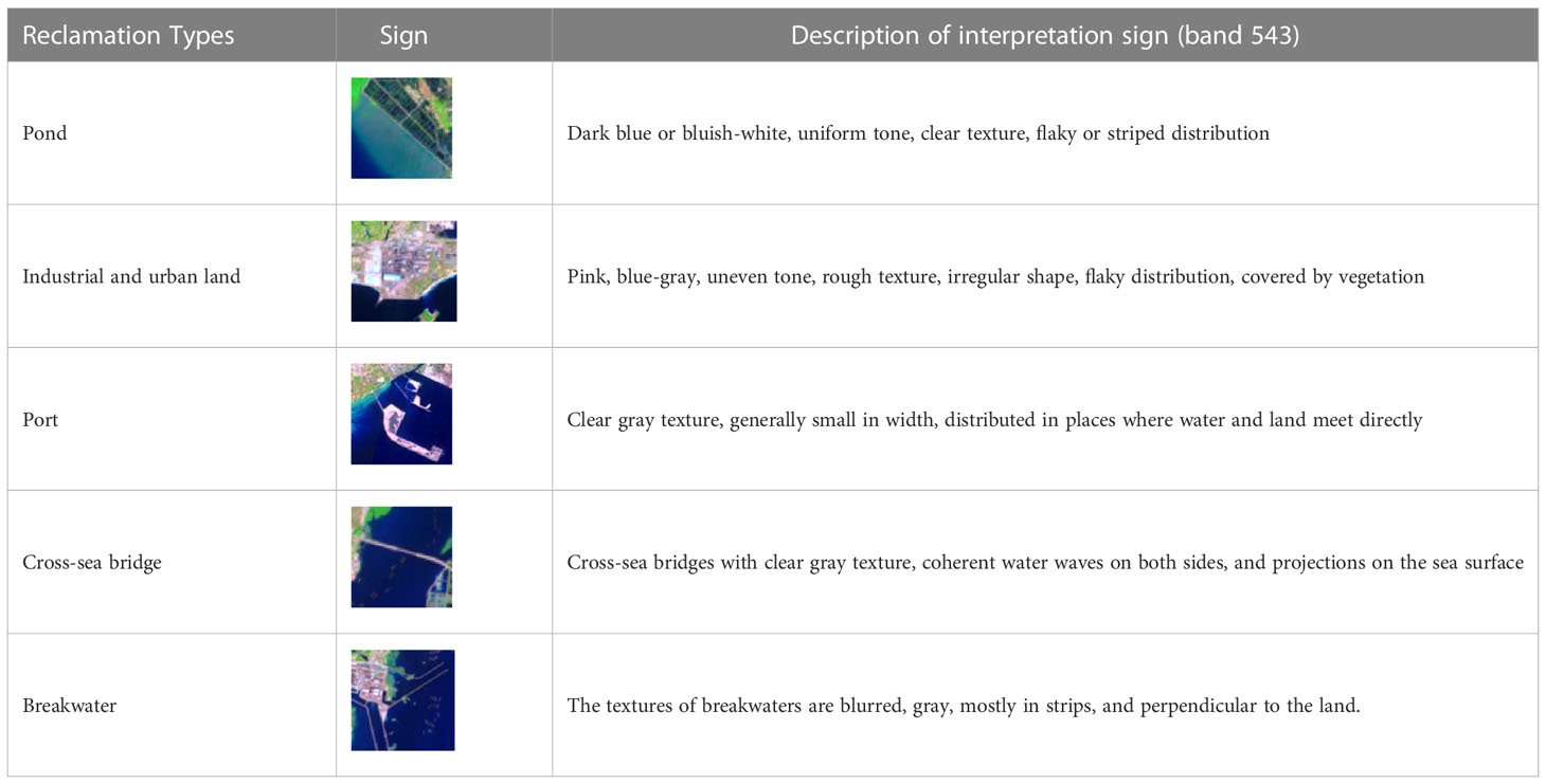
Table 2 Interpretation signs for different types of reclamation and utilization.
Validation: The extraction accuracy of reclamation was assessed by comparing the outputs with Google Earth imagery. A total of 100 control coordinate sites that covered all reclamation types were collected from Google Earth images to verify the accuracy of the visual interpretation of the reclamation. The overall accuracy was 97%, which indicated good performance.
2.4 Driving force analysis
2.4.1 Index selection
In China, economic development, population growth, agricultural requirements, and other industries contribute to the need to expand into the sea (Chee et al., 2023; Tian et al., 2016). On the basis of the preceding description, a hierarchical assessment indicator system was established (Table 3), and the definition of indicators was presented using Statistical Bulletins.
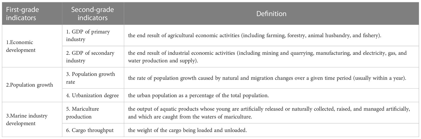
Table 3 Evaluation index system of the driving force factors of the reclamation.
2.4.2 Statistical analysis
Linear regression refers to the dependent variable as a linear function of one or more independent variables, subject to a random “disturbance” or “error” term (Ruivo et al., 2022). This method has been a widely used technique in finance and environment research with its advantages of simplicity in application, efficiency in computation, and ease of interpretation (Thompson et al., 2006; Gilli et al., 2019). In this study, linear regressions were applied to assess reclamation using continuous yearly variables, such as gross domestic product, population growth rate, urbanization degree, mariculture production, and cargo throughput. In this study, linear regression analysis was performed using SPSS 19.0 software.
Path analysis is an extension of multiple regression that can be used for investigating direct and indirect relationships between variables and latent variables (Wood and Brodie, 2016; Bello et al., 2020). Model fit is measured using the coefficient of determination (R2), and a high R2 indicates the goodness of fit of model equations. In this study, path analysis was performed to determine the overall effect of socioeconomic factors on reclamation, and the expected model of causal factors upfront was proposed as shown in Figure 3.

Figure 3 A path analysis model of the reclamation.
3 Result
3.1 Reclamation expansion
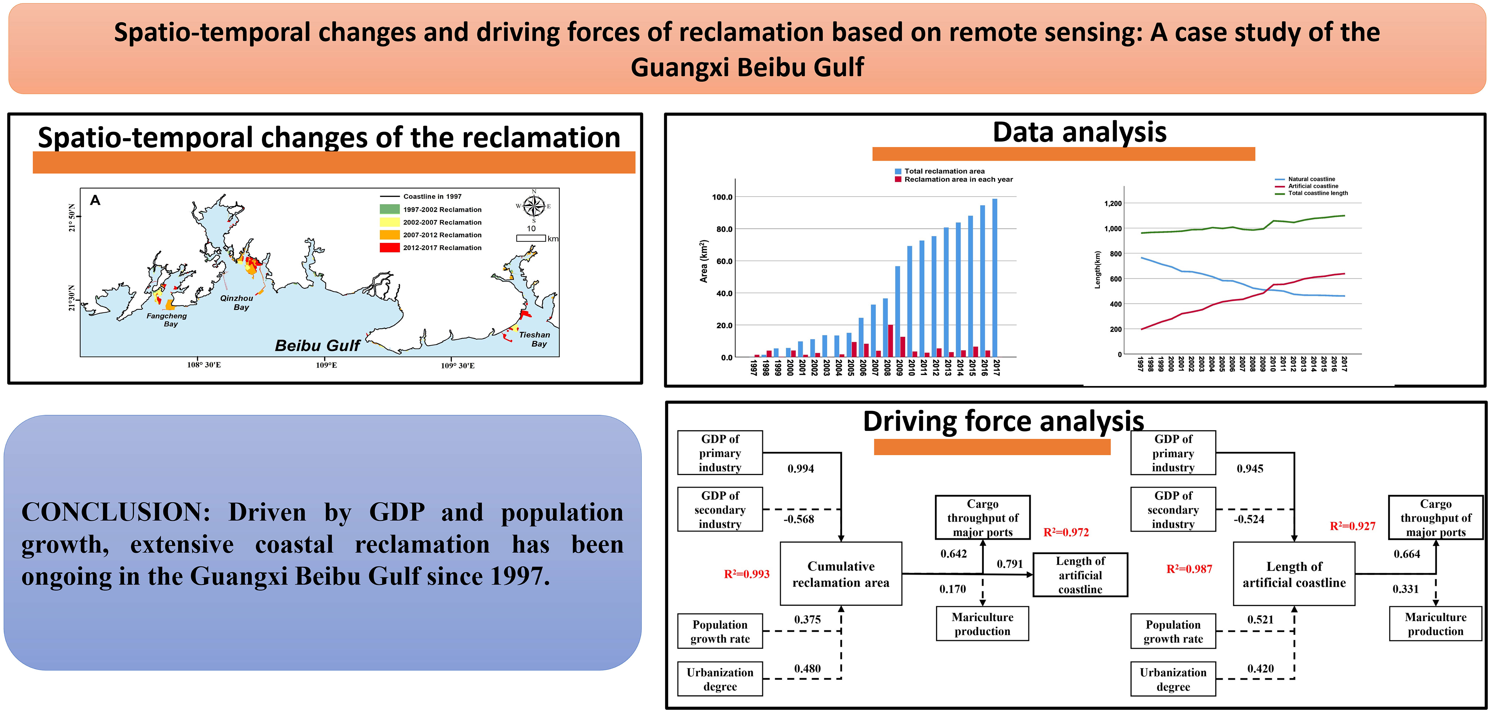
The development process of reclamation in the Guangxi Beibu Gulf is shown in Figure 4A. The increase in the cumulative reclamation area in the Guangxi Beibu Gulf was 98.6 km2 from 1997 to 2017, and the accumulated area of reclamation from 2007 to 2017 accounted for 82.3% of its total reclamation since 1987. This illustrated that large-scale reclamation activities in the coastal waters of Guangxi in the Beibu Gulf began after 2007, and happened mainly in three regions that have undergone great changes, particularly in Qinzhou Bay (42.5%) and Fangcheng Bay (20.7%) (Figure 4A). In Fangcheng Bay, the natural coastline was used for urban development and port land after 2001. In Qinzhou Bay, two nearly 7 km-long breakwaters were located on the western coast, which connect to the land and aim to protect the coast; additionally, a large reclamation project in Qinzhou Bay for urban and industrial use named Sandun covered an area of approximately 30 km2. The third region is located in Tieshan Bay, where three reclamation projects have been completed since 2001.
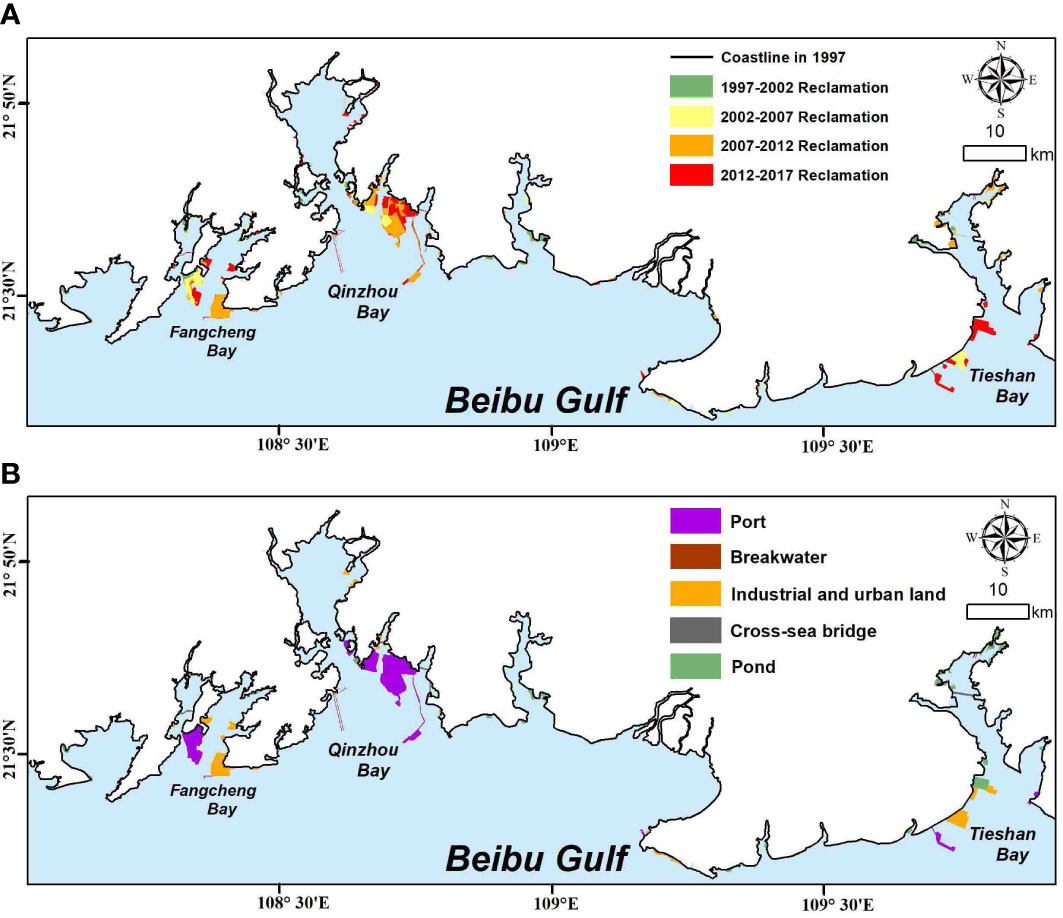
Figure 4 Spatio-temporal change of reclamation and its use types.
Figure 4B presents the areas of each coastal reclamation type along the Guangxi coast. Of all the reclamation projects, 44.8% could be attributed to ports. The ports, industrial and urban areas, ponds, cross-sea bridges, and breakwaters accounted for 30.9%, 20.3%, 2.4%, and 1.6% of the total reclaimed area within the Guangxi Beibu Gulf, respectively.
Figure 5 illustrates the cumulative areas of coastal reclamation in the Guangxi Beibu Gulf over the previous 20 years. It could clearly be seen that the rate of increase in reclamation in Guangxi first increased and then decreased from 1997 to 2017, reaching a peak of 54.1 km2 and with an average of 10.8 km2 per year over 2006-2010. After 2010, the rate of growth slowed significantly, with an average of 3.7 km2 per year from 2010-2017.
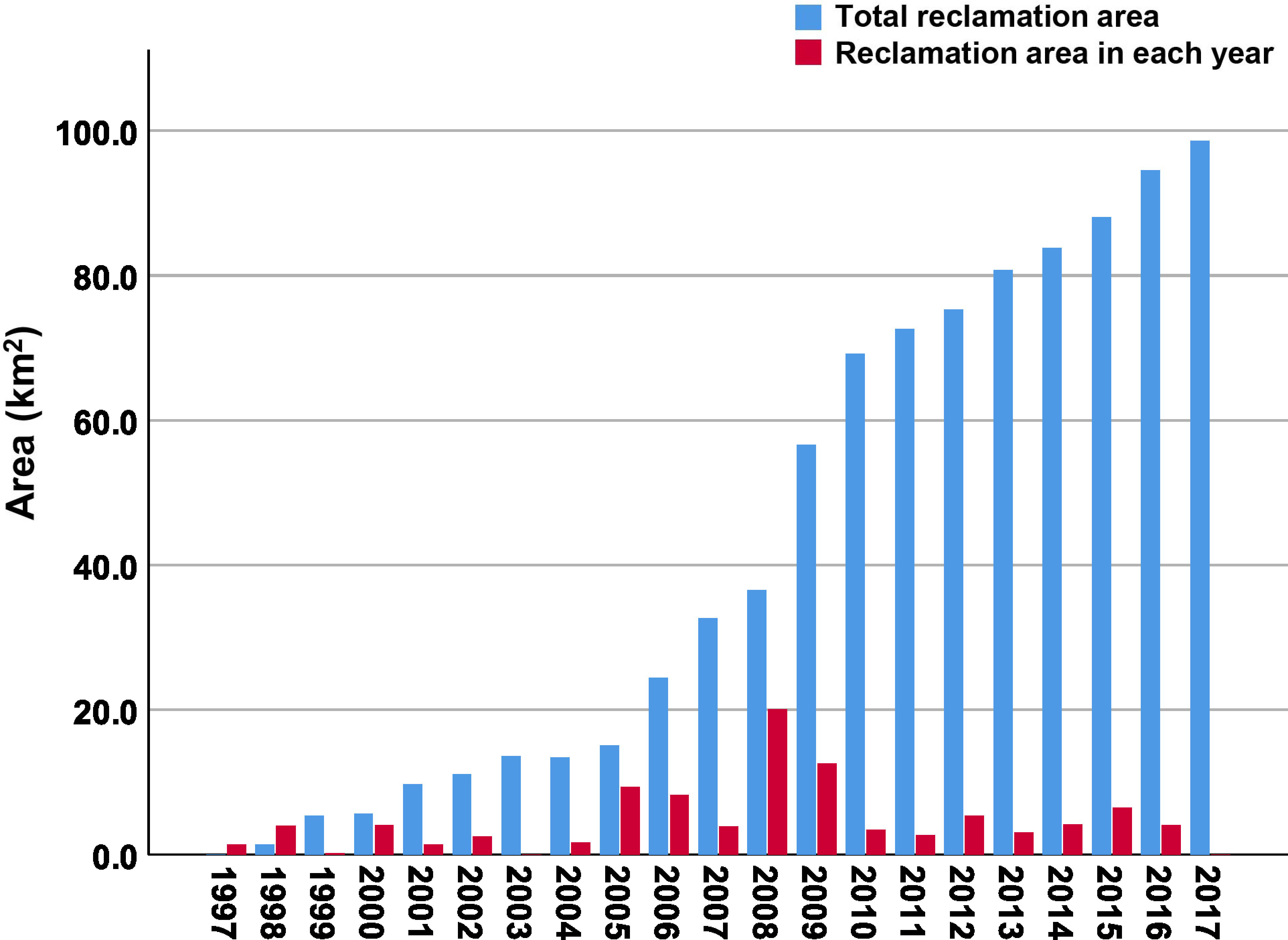
Figure 5 Changes in reclamation area from 1997 to 2017.
3.2 Reclamation-induced coastline change
As shown in Figure 6, in 1997 the coastline was mainly natural coastline, such as mangrove, beach, and estuary coastlines, accounting for 79.7% of the total coastline length of the Guangxi Beibu Gulf. After 2007, the length and proportion of the urban and industrial coastline and port coastline increased significantly, making the artificial shoreline jump from 20.3% (1997) to 58.1% (2017). In the past 20 years, natural coast has been reclaimed throughout the gulf, with three areas of particular concern: one in Fangcheng Bay (Figures 6A, E), another in Qinzhou Bay (Figures 6B, F), and the third is a large-scale breeding pond constructed after 2000 in the Nanliu River estuary, which was converted from unused land (Figures 6C, G). In terms of spatial distribution, the natural coastline was mainly distributed in the western parts of Fangcheng Bay and western parts of Qinzhou Bay, and the artificial coastline mostly distributed in Tieshan Bay, the eastern parts of Fangcheng Bay, and the coastal waters of the Nanliu River.
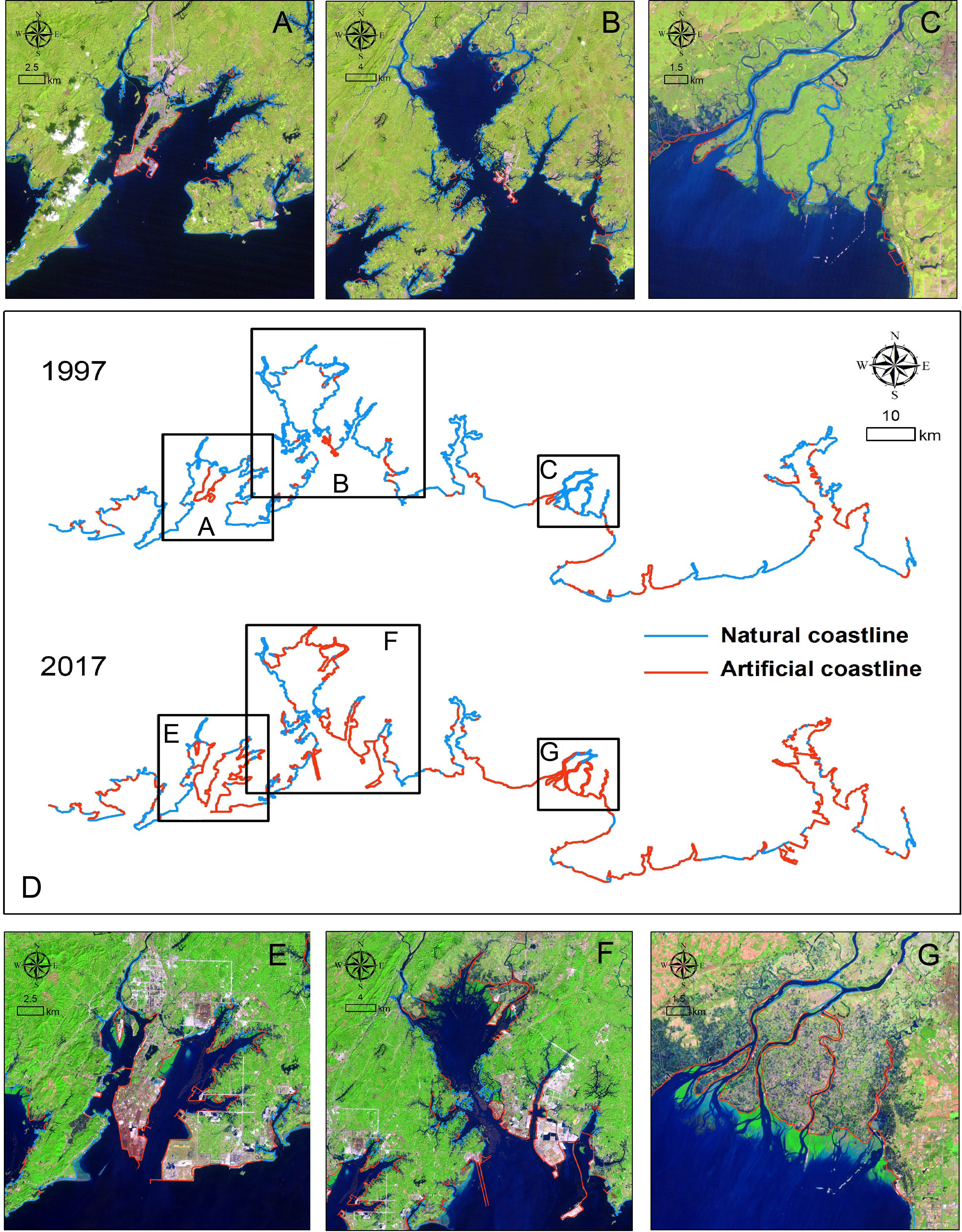
Figure 6 Spatio-temporal changes of the coastline in the Guangxi Beibu Gulf in 1997 and 2017 (D). The natural coast has been reclaimed throughout the entire gulf, where three regions have undergone great changes that were recorded by remote sensing observation, including: remote sensing images of Fangcheng Bay in 1997 (A) and 2017 (E); remote sensing images of Qinzhou Bay in 1997 (B) and 2017 (F); and remote sensing images of Nanliu River estuary in 1997 (C) and 2017 (G).
It is obvious that reclamation can greatly change the coastline length and type. For example, Landsat satellite data enabled us to obtain the coastline changes for large areas, i.e., bays like Qinzhou and Fangcheng, in a relatively short period of time. In addition, reclamation can also reshape the geometrical morphology of coastlines, such as the Nanliu River estuary where the natural coastline was converted to a pond coastline. This showed that the artificial coastline length and total coastline length had increased during the 20-year period (Figure 7), while the natural coastline showed a slow but steady decrease from 1997 to 2017. We further analyzed the trend of the artificial coastline increase and noted a sharp increase before 2010. It increased by 2.8 times from 195.1 km in 1997 to 550.6 km in 2010.
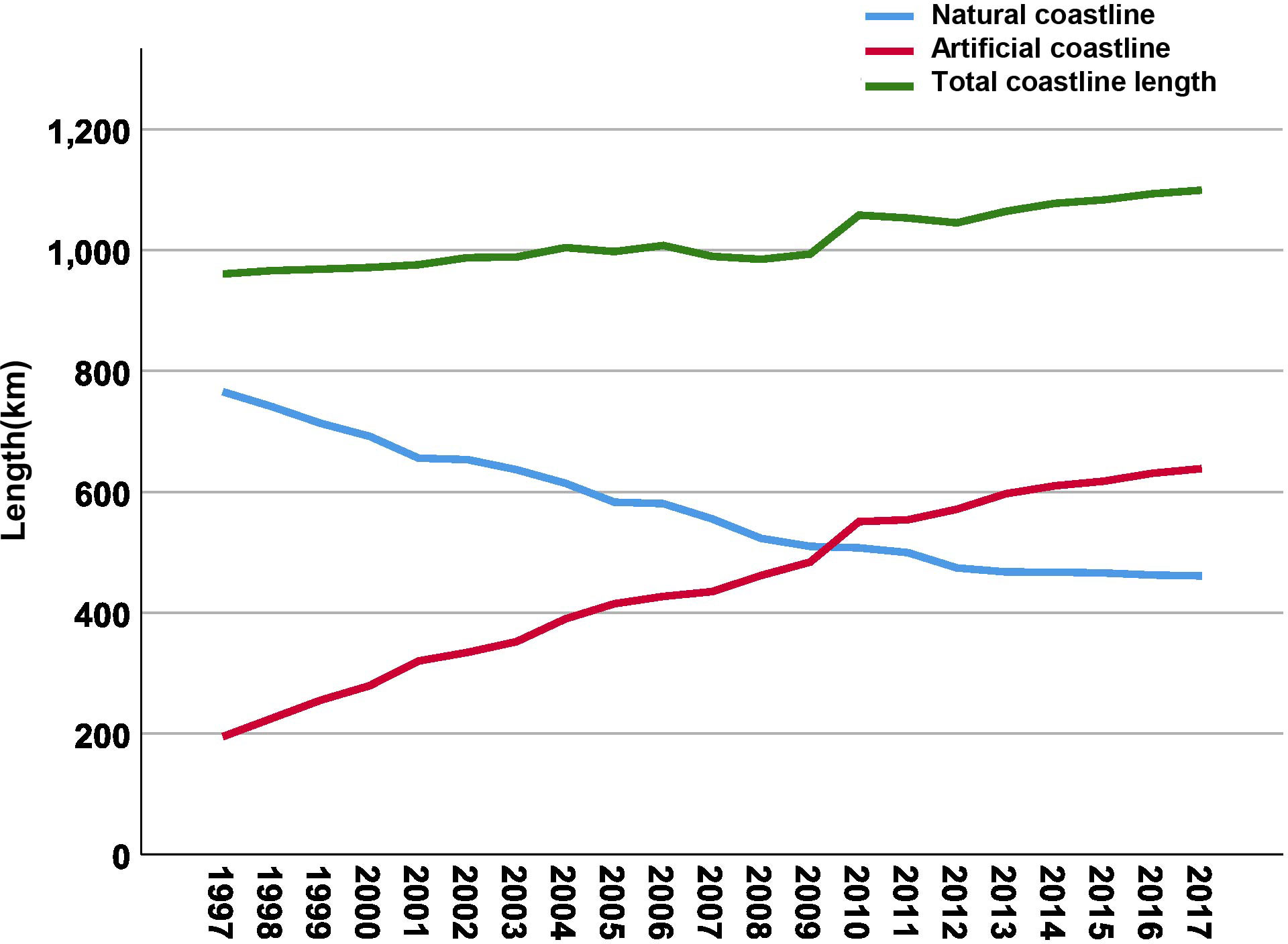
Figure 7 Changes in coastline length from 1997 to 2017.
3.3 Driver forces of reclamation
In the linear regression model of reclamation (Figures 8A–C), the high R2 for both GDP of primary industry (R2 = 0.952) and degree of urbanization (R2 = 0.907) indicated these factors have promoted reclamation. It was clear that the growth of the GDP of the primary industry and the degree of urbanization was positively correlated with the area of reclamation, which significantly increased. In the linear regression model of artificial coastlines (Figures 8D–F), the high R2 for both GDP of the secondary industry (R2 = 0.919) and the degree of urbanization (R2 = 0.977) indicated these factors have promoted artificial coastlines.
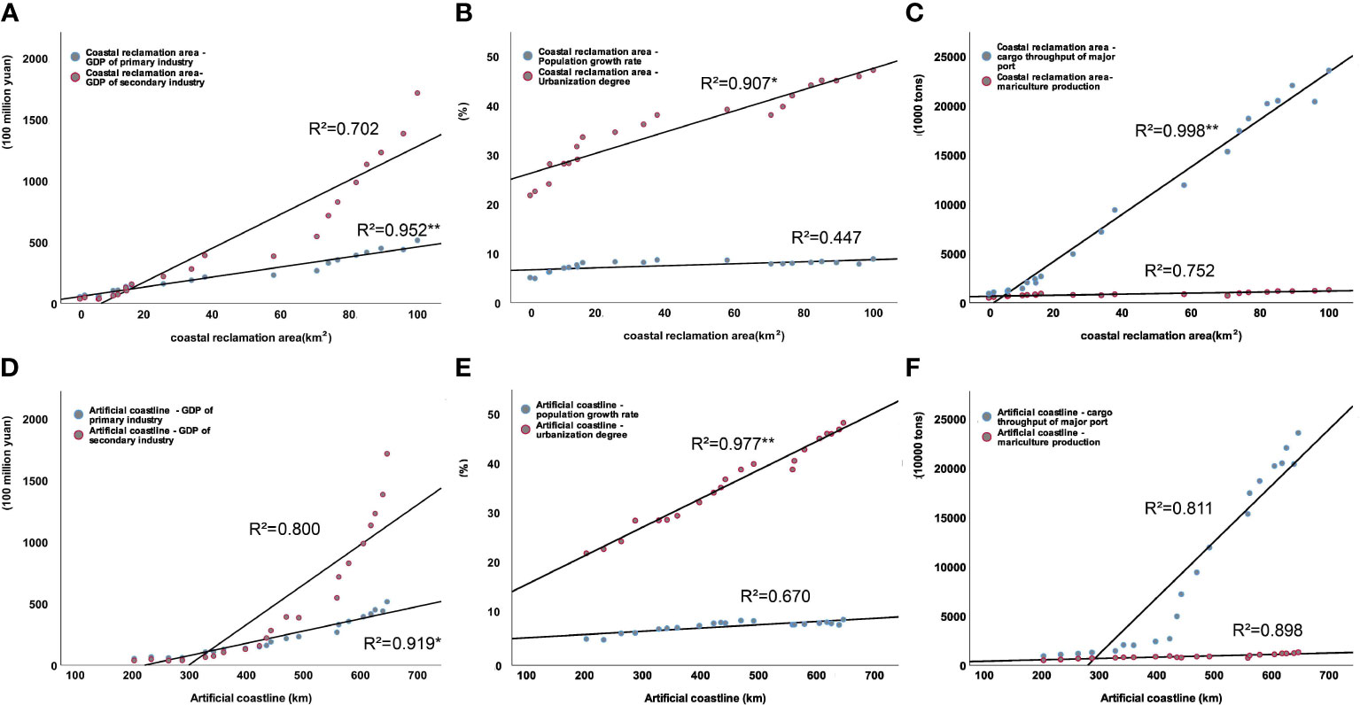
Figure 8 Linear regression between coastal reclamation and socio-economic factors, including economic development (A), population growth (B), and marine industry development (C) in coastal cities. (D–F) denotes the linear regression between coastline change and socio-economic indicators.
In the path analysis of the Guangxi Beibu Gulf reclamation model (Figure 9A), the GDP of the primary industry had the largest influence on the cumulative reclamation area (standardized betas of the regression equations: 0.994). The population growth rate and degree of urbanization both had a positive influence relationship with the cumulative reclamation area, the standardized betas of which being 0.480 and 0.375, respectively. However, our hypothesis concerning economic contribution was inconsistent with secondary industry GDP. In this model, the GDP of secondary industry had a weakly negative relationship with cumulative reclamation area (standardized beta: −0.356) and the length of artificial coastlines (standardized beta: −0.524); this was because the expanded reclamation that gradually moved toward industrialization had a low population, GDP, and urban development area before any infrastructure-related to industry was built. Moreover, the cumulative reclamation areas showed positive effects on the length of artificial coastlines and the cargo throughput of major ports, with standardized betas of 0.791 and 0.642, respectively. In the path analysis of the Guangxi Beibu Gulf coastline models (Figure 9B), the GDP of primary industry also had the largest influence on the length of artificial coastlines (standardized betas: 0.945). Artificial coastlines were found to have a positive direct effect on the cargo throughput of major ports (standardized betas: 0.664).
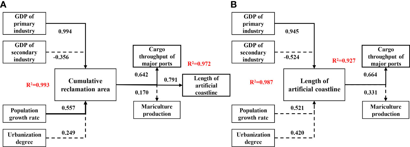
Figure 9 Path analysis to estimate the reclamation (A) and artificial coastline (B) and relationships between socio-economic factors. Numbers show the standardized betas of the regression equations. Solid lines indicate that the effect is significant; dotted lines indicate that the effect is insignificant. The R2 for all the equations was high and ranged between 0.927 and 0.993, indicating good performance.
4 Discussion
4.1 Verification of reclamation and its driving forces
This study encompassed a 21-year record and 42 remote sensing images of the Guangxi Beibu Gulf. Importantly, these remote sensing images provided insights into the changes in coastline at different temporal and spatial scales, especially in bays where artificial reclamation was significant. Throughout the entire 21-year record, approximately 36.1% of the coastline exhibited statistically significant man-made reclamation, which occurred in river estuaries and bay mouths (Figure 6). Furthermore, the percentage of artificial coasts rose rapidly from 42.5% in 1997 to 72.7% in 2017, as a result of high-intensity human activities including reclaiming land from the sea. We compared results over the same period and found that the overall error was 4.1-9.8% (Sun et al., 2020). The causes of the conversion of natural shorelines to artificial shorelines included reclamation and land-use changes. Based on the result for the area, reclamation was the dominant factor leading to the change of coastline, and its contribution rate reached 62.9% (Figure 6).
According to the results of the linear regression modeling, GDP development was the main reason for the change of coastal reclamation in the Guangxi Beibu Gulf, which was consistent with previous studies in other coastal regions of China (Wang et al., 2014; Chen et al., 2017). However, the driving mechanism of coastal reclamation is complicated (Meng et al., 2017). Meng et al., 2017 confirmed that the employees in marine industries and areas of mariculture had a positive effect on the change of coastal reclamation in China. Jiang et al., 2021 further found that policy implementation controlled and limited the scale of coastal reclamation. In addition, the driving forces of reclamation in the world have already been studied by other scholars. The study by Chee et al. (2023) showed that the rise in human populations, urbanization, and reduction in construction costs led to a large amount of reclamation in Malaysia. In the United Kingdom, approximately 6,500 ha of the Shannon estuary lowlands have been reclaimed for agricultural development (Healy and Hickey, 2002). As a result, a variety of socioeconomic factors influence land reclamation. We aimed to provide a new index system that evaluated the socioeconomic factors driving land reclamation. The path analysis is capable of exploring the driving forces of reclamation projects using varying regression equations, and the findings showed that population growth, economic development, and marine industry development all influenced the spatio-temporal changes in reclamation in the Guangxi Beibu Gulf.
4.2 Economic benefits of reclamation
The Guangxi Beibu Gulf is one of the most important economic zones in China. However, its limited land supply has led to insufficient space for its urban expansion, especially on the west coast of Qinzhou Bay and the south coast of Fangcheng Bay which both contain mangrove, muddy, sandy shoals, and low-level terrain. In order to obtain expanded space for further developments in ports and ponds, intensive reclamation projects have taken place in these regions (Figure 4B). Since 1997, two large-scale reclamation activities have also occurred and led to the industrial development of cities around the Beibu Gulf. There has been a stark increase in the number of coastal reclamation projects for aquaculture ponds, breakwaters, port terminals, cross-sea bridges, and industrial developments in the coastal cities. According to statistics, from 1997 to 2017, the cargo throughput of the main ports of Guangxi increased by 11.6 times, and the aquaculture production increased by 3.3 times (China Marine Statistical Yearbook). With the exploitation of reclamation, the growth of the marine industry has gradually taken the lead in coastal cities’ overall economic expansion.
4.3 Other driving force
The reclamation in Guangxi has grown rapidly since 2006, at an average of 10.8 km2 per year from 2006-2010. After 2010, the rate of growth slowed significantly, with an average of 3.7 km2 per year from 2010-2017. This decreasing trend was highlighted as the reason the Beibu Gulf has vigorously developed ports and tourism to drive economic benefits in the past seven years. Although the extension of Qinzhou and Fangcheng ports to the sea area is limited, more emphasis has been placed on port expansion after 2010 than on reclaiming coastal land for ponds and construction land in the Guangxi Beibu Gulf. This was the major reason for the declining trend in the yearly reclamation area in the Beibu Gulf region. In addition, the spread of land reclamation also became relatively sluggish to safeguard the environment and ecology (Zhao et al., 2021).
From the path analysis between the reclamation area and indicators (Figure 9), it was found that socio-economic factors had significant effects on reclamation which, in turn, promoted marine industrial development and increased revenue. However, the evaluation index system of the driving force factors of the reclamation may have some limitations that need to be improved in future studies: economic development, population growth, and marine industry development were focused on without the consideration of the unquantifiable indicators, such as institutional policies and technical measures (Chee et al., 2023). For example, the implementation of the ‘2006 Beibu Gulf Development Plan’ provides a good opportunity and platform for the development of ports, logistics, and coastal industry; the reduction in construction costs brought about by technological advancements has also made land reclamation more appealing to investors (Miao and Xue, 2021).
4.4 Suggestions for coastal reclamation
Although coastal reclamation projects conducted along the Guangxi coast have boosted economic development, they have also inevitably brought potential impacts on coastal zones, such as reshaping the coastline (Ma et al., 2014; Md et al., 2019), altering land-use types (Zhao et al., 2021), and changing the ecology and environment (Zhang et al., 2020; Lu et al., 2022). Management of the Guangxi Beibu Gulf is currently focused on the social and economic benefits of reclaimed land while ignoring the ecological and environmental influence. As a result, environmental pollution in reclaimed areas is becoming increasingly severe, and biodiversity is being harmed, especially in oil production areas and mariculture ponds (Chen et al., 2018; Lin et al., 2021), which are gradually becoming the primary constraint affecting the sustainable utilization of reclaimed land and the sustainable development of the coastal economy. On the basis of the Guangxi Beibu Gulf reclamation conditions, we suggest strengthening the scientific control and efficient use of coastal reclaimed land and paying attention to the combination of environmental protection and management based on adequate knowledge of the coastal and marine ecosystems. In addition, in areas of intensive reclamation, such as Fangcheng Bay and Qinzhou Bay, reclamation activities should be timely regulated and properly reduced according to regular monitoring and assessment (Shen et al., 2016).
At present, coastal reclamation is in transition from a high-intensity development stage to a more conservative and prudent stage in Guangxi. However, when it comes to resolving the conflict between the economy and land resources, coastal reclamation remains the first option. To keep regional economic development sustainable, we must weigh the benefits and drawbacks of reclamation and economic growth, and then we must implement suitable coastline reclamation measures.
5 Conclusions
The reclamation evaluation of the Guangxi Beibu Gulf indicated the following: 1) since 1997, large-scale coastal reclamation has been conducted in the Guangxi Beibu Gulf, with a total area of 98.6 km2, of which three regions, Fangcheng Bay, Tieshan Bay, and Qiznhou Bay, have undergone great changes; 2) spatio-temporal changes of reclamation were affected by the combination of population growth, economic development, urbanization, and marine industry development in coastal cities.
Data availability statement
The original contributions presented in the study are included in the article/supplementary material. Further inquiries can be directed to the corresponding authors.
Author contributions
JL: conceptualization, data curation, formal analysis, investigation, methodology, software, validation, visualization, writing - original draft, and writing - review and editing. YZ: data curation, formal analysis, methodology, supervision, and visualization. HS: conceptualization, funding acquisition, methodology, project administration, and resources. XL: formal analysis, methodology, writing - review and editing, project administration, and resources. All authors contributed to the article and approved the submitted version.
Funding
This study was supported by the National Natural Science Foundation of China (No.U1806214 & No.51779048) and the National Key Research and Development Program of China (No. 2018YFD0900806).
Conflict of interest
The authors declare that the research was conducted in the absence of any commercial or financial relationships that could be construed as a potential conflict of interest.
Publisher’s note
All claims expressed in this article are solely those of the authors and do not necessarily represent those of their affiliated organizations, or those of the publisher, the editors and the reviewers. Any product that may be evaluated in this article, or claim that may be made by its manufacturer, is not guaranteed or endorsed by the publisher.
References
Bello A., Han Y., Zhu. H. F., Deng. L. T., Yang. W., Meng. Q. X., et al. (2020). Microbial community composition, co-occurrence network pattern and nitrogen transformation genera response to biochar addition in cattle manure-maize straw composting. Sci. Total Environ. 721, 137759. doi: 10.1016/j.scitotenv.2020.137759
Bisaro A., de Bel M., Hinkel J., Kok S., Bouwer L. M. (2020). Leveraging public adaptation finance through urban land reclamation: Cases from Germany, the Netherlands and theMaldives. Clim. Change 160 (4), 671–689. doi: 10.1007/s10584-019-02507-5
Bugnot A. B., Mayer-Pinto M., Airoldi L., Heery E. L., Johnston L. P., Critchley E. M. A., et al. (2020). Current and projected global extent of marine built structures. Nat. Sustain. 4, 33–41. doi: 10.1038/s41893-020-00595-1
Chee S. Y., Tan M. L., Tew Y. L., Sim Y. K., Yee J. C., Chong A. K. M. (2023). Between the devil and the deep blue sea: Trends, drivers, and impacts of coastal reclamation in Malaysia and way forward. Sci. Total Environ. 858, 159889. doi: 10.1016/j.scitotenv.2022.159889
Chen F., Jing L., Qian B., Zhai W., Peng H., Kai C. (2018). Geochemical assessment and spatial analysis of heavy metals in the surface sediments in the Eastern beibu gulf: a reflection on the industrial development of the south China coast. Int. J. Environ. Res. Public Health 15, 496. doi: 10.3390/ijerph15030496
Chen W., Liu H., Li Y., Su J. (2017). Monitoring and analysis of coastal reclamation from 1995-2015 in tianjin binhai new area, China. Sci. Rep. 7, 3850. doi: 10.1038/s41598-017-04155-0
Gilli M., Maringer D., Schumann E. (2019). “Chapter 10 - optimization problems in finance,” in Numerical methods and optimization in finance (Second edition). Eds. Gilli M., Maringer D., Schumann E. (Switzerland: World Publishing Corporation), 219–228.
Guangxi Statistical Yearbook. (1995–2015). Guangxi statistical yearbook (China Ocean Press). Available at: https://www.yearbookchina.com/naviBooklist.
Han Y., Wei F., Ye G., Yang S., Ma P., Hu W. (2018). A study on evaluation the marine carrying capacity in guangxi province, China. Mar. Policy. 91, 66–74. doi: 10.1016/j.marpol.2018.02.003
Healy M. G., Hickey K. R. (2002). Historic land reclamation in the intertidal wetlands of the Shannon estuary, western Ireland. J. Coast. Res. 36 (10036), 365–373. doi: 10.2112/1551-5036-36.sp1.365
Herbeck J., Flitner M. (2019). Infrastructuring coastal futures: key trajectories in southeast Asian megacities. DIE ERDE - J. Geographical Soc Berlin 150 (3), 118–130. doi: 10.12854/erde-2019-451
Jiang S., Xu N., Li Z., Huang. C. (2021). Satellite derived coastal reclamation expansion in China since the 21st century. Global Ecol. Conserv. 30, e01797. doi: 10.1016/j.gecco.2021.e01797
Kennish M. J. (2001). Coastal salt marsh systems in the U.S.: A review of anthropogenic impacts. J. Coast. Res. 17, 731–748.
Lao Q., Liu G., Zhou X., Chen F., Zhang S. (2021). Sources of polychlorinated biphenyls (PCBs) and dichlorodiphenyltrichloroethanes (DDTs) found in surface sediment from coastal areas of beibu gulf: A reflection on shipping activities and coastal industries. Mar. pollut. Bull. 167, 112318. doi: 10.1016/j.marpolbul.2021.112318
Lin H., Lan W., Feng Q., Zhu X., Li T., Zhang R., et al. (2021). Pollution and ecological risk assessment, and source identification of heavy metals in sediment from the beibu gulf, south China Sea. Mar. pollut. bulletin. 168, 112403. doi: 10.1016/j.marpolbul.2021.112403
Lu J., Zhang Y., Lv X., Shi H. (2022). The temporal evolution of coastlines in the bohai Sea and its impact on hydrodynamics. Remote Sens. 14, 5549. doi: 10.3390/rs14215549
Lyu H., Song D., Zhang S., Wu W., Bao X. (2022). Compound effect of land reclamation and land-based pollutant input on water quality in qinzhou bay, China. Sci. Total Environ. 826, 154183. doi: 10.1016/j.scitotenv.2022.154183
Ma Z., Melville D. S., Liu J., Chen Y., Yang H., Ren W., et al. (2014). Rethinking china’s new great wall. Science. 346 (6212), 912–914. doi: 10.1126/science.1257258
Md S. K., Das J., Kabir M. H. (2019). Monitoring coastline changes in the coastal belt of chittagong in Bangladesh using GIS and remote sensing. Asian. J. Geogr. Res. 1–13. doi: 10.9734/ajgr/2019/v2i330087
Meng W. Q., Hu B. B., He M. X., Liu B. Q., Mo X. Q., Li H. Y., et al. (2017). Temporal-spatial variations and driving factors analysis of coastal reclamation in China. Estuar. Coast. Shelf. 191, 39–49. doi: 10.1016/j.ecss.2017.04.008
Miao D., Xue Z. (2021). The current developments and impact of land reclamation control in China. Mar. Policy 134, 104782. doi: 10.1016/j.marpol.2021.104782
Muller J. R. M., Chen Y. P., Aarninkhof S. G. J., Chan Y. C., Piersma T., van Maren D. S., et al. (2020). Ecological impact of land reclamation on jiangsu coast(China): a novel ecotope assessment for tongzhou bay. Water Sci. Eng. 13 (1), 57–64. doi: 10.1016/j.wse.2020.04.001
Powell M. A. (2021). Singapore’s lost coast: Land reclamation, national development and the erasure of human and ecological communities 1822-present. Environ. Hist. 27 (4), 635–663. doi: 10.3197/096734019x15631846928710
Ruivo C. R., Apaolaza-Pagoaga X., Nicola G. D., Carrillo-Andrés A. (2022). On the use of experimental measured data to derive the linear regression usually adopted for determining the performance parameters of a solar cooker. Renewable Energy 181, 105–115. doi: 10.1016/j.renene.2021.09.047
Shen C. C., Shi H. H., Zheng W., Li F., Peng S., Ding D. (2016). Study on the cumulative impact of reclamation activities on ecosystem health in coastal waters. Mar. pollut. Bull. 103, 144–150. doi: 10.1016/j.marpolbul.2015.12.028
Sun X., Zhang L., Lu S. Y., Tan X. Y., Chen K. L., Zhao S. Q., et al. (2020). A new model for evaluating sustainable utilization of coastline integrating economic output and ecological impact: A case study of coastal areas in beibu gulf, China. J. Cleaner Production. 271, 122423. doi: 10.1016/j.jclepro.2020.122423
Suzuki T. (2003). Economic and geographic backgrounds of land reclamation in Japanese ports. Mar. pollut. Bull. 47, 226–229.
Temmerman S., Meire P., Bouma T. J. (2013). Ecosystem-based coastal defence in the face of global change. Nat. 504, 79–83. doi: 10.1038/nature12859
Thompson J. A., Pena-Yewtukhiw E. M., Grove J. H. (2006). Soil-landscape modeling across a physiographic region: Topographic patterns and model transportability. Geoderma. 133, 57–70. doi: 10.1016/j.geoderma.2006.03.037
Tian B., Wu W. T., Yang Z. Q., Zhou Y. X. (2016). Drivers, trends, and potential impacts of long-term coastal reclamation in China from 1985 to 2010. Estuar. Coast. Shelf. Sci. 170, 83–90.
Wang C., Cai L., Wu Y., Ouyang Y. (2021). Numerical simulation of the impact of an integrated renovation project on the maowei Sea hydrodynamic environment. Sci. Rep. 11, 17059. doi: 10.1038/s41598-021-96441-1
Wang W., Liu H., Li Y., Su J. (2014). Development and management of land reclamation in China. Ocean Coast. Manage. 102, 415–425.
Wood C. W., Brodie E. D. (2016). Natural selection, measuring. encyclopedia of evolutionary biology. Ed. Kliman R. M. (America: Oxford University Press), 104–111.
Yu G., Liao Y., Zhao W., Chen Q., Kou J., Liu X. (2021). Research on integrated coastal zone management based on remote sensing: A case study of guangxi beibu gulf. Regional Stud. Mar. Sci. 44, 101710. doi: 10.1016/j.rsma.2021.101710
Zhang Y., Chen R., Wang Y. (2020). Tendency of land reclamation in coastal areas of shanghai from 1998 to 2015. Land Use Policy. 91 (2020), 104370.
Zhao D., Xiao M., Huang C., Liang Y., Yang Z. (2021). Land use scenario simulation and ecosystem service management for different regional development models of the beibu gulf area, China. Remote Sens. 13, 3161. doi: 10.3390/rs13163161
Keywords: coastline changes, reclamation, driving factor, linear regression, path analysis
Citation: Lu J, Zhang Y, Shi H and Lv X (2023) Spatio-temporal changes and driving forces of reclamation based on remote sensing: A case study of the Guangxi Beibu Gulf. Front. Mar. Sci. 10:1112487. doi: 10.3389/fmars.2023.1112487
Received: 30 November 2022; Accepted: 30 January 2023;
Published: 10 February 2023.
Edited by:
Shiqiu Peng, State Key Laboratory of Tropical Oceanography, South China Sea Institute of Oceanology, Chinese Academy of Sciences, ChinaReviewed by:
Chunyu Zhao, Dezhou University, ChinaZhijian Jiang, South China Sea Institute of Oceanology (CAS), China
Copyright © 2023 Lu, Zhang, Shi and Lv. This is an open-access article distributed under the terms of the Creative Commons Attribution License (CC BY). The use, distribution or reproduction in other forums is permitted, provided the original author(s) and the copyright owner(s) are credited and that the original publication in this journal is cited, in accordance with accepted academic practice. No use, distribution or reproduction is permitted which does not comply with these terms.
*Correspondence: Honghua Shi, c2hpaG9uZ2h1YUBmaW8ub3JnLmNu; Xianqing Lv, eHFpbmdsdkBvdWMuZWR1LmNu