 Manuel Espino
 Joanna Staneva
 Enrique Alvarez-Fanjul
 Agustín Sánchez-Arcilla
- 1Laboratory of Maritime Engineering, Polytechnic University of Catalonia, Barcelona, Spain
- 2Institute of Coastal Systems - Analysis and Modeling, Helmholtz Centre for Materials and Coastal Research (HZG), Geesthacht, Germany
- 3Mercator Ocean (France), Ramonville-Saint-Agne, Toulouse, France
Editorial on the Research Topic
Coastal Extension of CMEMS Products. Models, Data and Applications
Recent advances in metocean operational products, with models at different scales and observations that combine in-situ and satellite data, have enabled in recent years a significant improvement in the range of coastal applications and analyses. Coastal processes and products, however, have been shown to present larger errors than the corresponding open ocean results, requiring a deeper and detailed knowledge of hydro-morpho-bio-chemical interactions to support robust predictions for shallow water domains. Coastal applications, thus, demand an increasing resolution together with an improved accuracy and lead forecast times to comply with stakeholder requirements.
The papers in this Reseach Topic show how applications may steer the development of models and data aggregations, enlarging the range of derived products and their adequacy to present challenges in coastal domains. The collection of papers in this Research Topic addresses coastal processes at different regions and in terms of different key variables that include winds, waves, currents, trajectories and concentrations. The papers are generally based on CMEMS products and refer to the extension of these products towards the coast for a variety of applications. These papers are related to several advanced research projects, among them the EU H2020 CEASELESS project.
The presented collection of papers includes a sub-set that tackles the combination of models and data to improve predictions and analyses of sea surface dynamic topography and temperature, including new aggregations of in-situ, radar and satellite data that consider, for instance, the mid wave infrared channel.
Another sub-set of papers deals with model coupling and boundary plus initial conditioning, showing the benefits of satellite data, in particular Sentinel-1, and ocean–atmospheric coupling to reduce undesired variability and to improve the characterization of low pressure centers, both in terms of position and trajectories.
This work is supplemented by another sub-set of papers that analyzes the benefits of data assimilation for coastal wave fields, in spite of the short memory of coastal systems for wave processes. The results show improvement at short lead-times and for now-casts. A complementary analysis for circulation fields, based on 4D variational assimilation has been also proposed, in terms of cost function gradients that reduce systematic errors associated with bathymetry, bottom roughness, open boundary forcing, meteo forcing and turbulence closures.
The presented papers address model capabilities for simulating tropical cyclones and mid latitude extreme events, considering the role of sea surface roughness and the development of platforms for early warnings. These platforms combine sea, swell and tsunami waves and the considered models cover structured and unstructured grids. The papers also discuss the role of flexible meshes, which become more beneficial for complex coastal systems such as deltas or, in general, for river-delta-coast continuums. This is exemplified by high resolution and accuracy simulations of channeled wind fields along river and deltaic valleys, here illustrated by a sample of results for the Ebro delta on the Spanish Mediterranean coast (Figure 1).
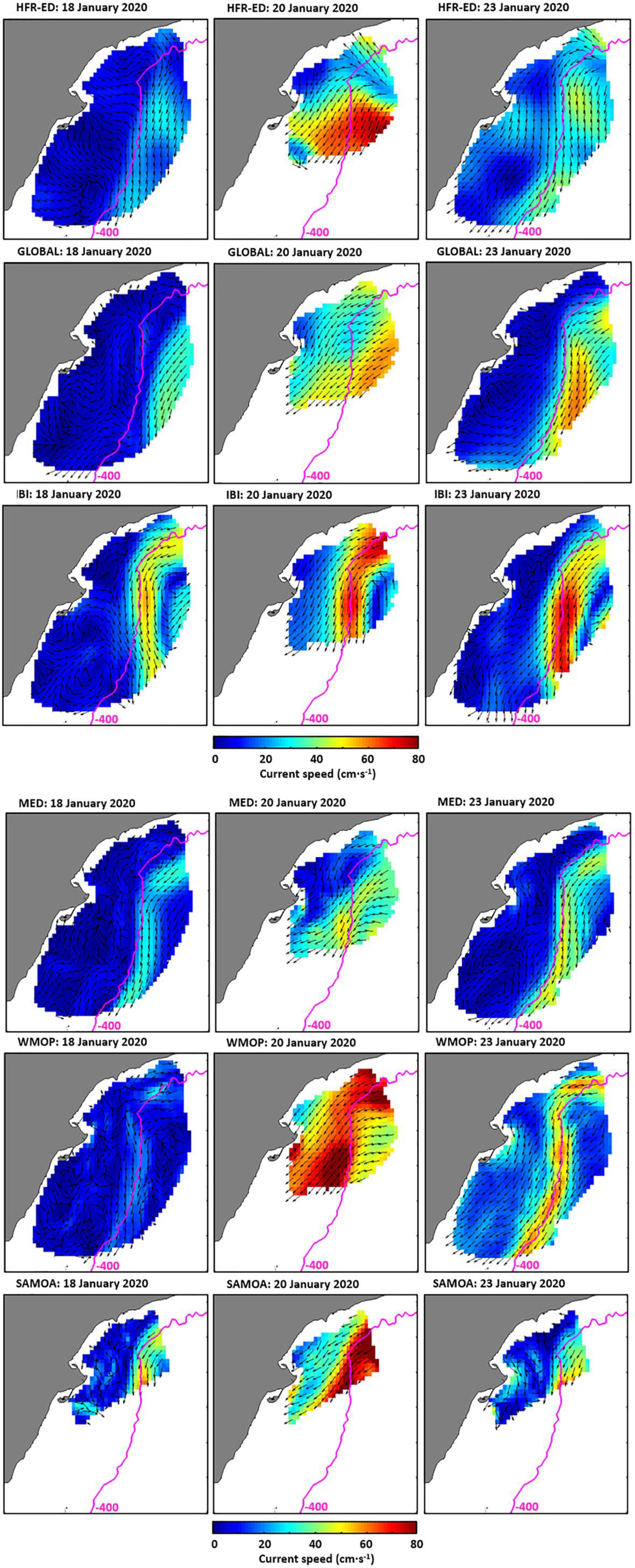
Figure 1 Model validation with HF radars observations: currents at the Ebro delta observed by the HF radar (1st row) and simulated by GLO (2nd row), MED (3rd row), IBI (4th row), WMOP (5th row) and SAMOA (6th row), on the 19th (1st column), 20th (2nd column), and 21st (3rd column) of January. Model validation with HF radars observations: currents at the Ebro delta observed by the HF radar (1st row) and simulated by GLO (2nd row), MED (3rd row), IBI (4th row), WMOP (5th row) and SAMOA (6th row), on the 19th (1st column), 20th (2nd column), and 21st (3rd column) of January.
A sub-set of papers is dedicated to the importance of numerical simulations that consider non-linear interactions dominant in coastal domains. The papers consider tidal, wind and fresh water forcing and the sensitivity of the resulting circulation to these interacting terms. The effect of river forcing, small channel discharges and met-ocean gradients included induced by coastal topo-bathymetric irregularities have been addressed for coastal systems such as deltas, estuaries or fiords. Obtained results show the importance of high resolution but stable meteorological fields, together with time referenced and reliable bathymetric data that increase the reliability of simulated non-linear interactions. The role of bathymetrical evolution, typical of coastal shallow areas, has been assessed for current patterns, velocities, surges, tidal components, temperature fields and salinity patterns, showing the importance of introducing such an updated bathymetry in the simulations.
The inclusion of recent advances in morphodynamic modelling and topo-bathymetrical data recovery will improve the quality of met-ocean simulations for coastal areas. This conclusion also applies to the quality of coupled hydro-morpho-bio-chemical simulations, where bathymetry plays a key role in 3D models for accurately reproducing stratification, oxygen depression and ammonium accumulation, associated to the vertical exchange of sedimentary and organic particles.
Several papers have addressed the importance of high resolution for meteorological and oceanic processes, assessing the importance of consistent forcing, reliable domain geometry and the suitability of modelling tools for transient events. The analysis has been based on the quality of reproduced surges, wind-waves, long period oscillations and current intensifications, particularly for extreme events such as the Gloria storm in January 2020. The performance of coastal models to predict sea levels, waves and currents for these extreme events, including cyclones has been discussed in terms of model set-ups, dominant processes and boundary conditions.
Most papers are based on CMEMS products, discussing the potential and limitations of higher resolution coastal models to extend these products towards the coast, particularly under severe weather events. The papers include model inter comparisons for these events and how the inclusion of such extremes should modify the present probability distributions, with implications for risk assessments and the design of coastal and harbour infrastructures. Here in situ data, including HF radars, plays a key role providing a time resolution much better suited to the short duration of some of these storms, which for instance is below a 5-day threshold in the Mediterranean, which coincides with the revisit times of many satellite data.
The provision of high-resolution results, covering the sharp gradients of coastal areas, requires a smart combination of data and models, such as the ones presented in many papers within this issue. Relocatable models, with flexible grids and incorporating wave-induced coastal processes, are a necessary element for many coastal applications, as discussed in the papers. Model coupling is required for accuracy and reliability reasons, particularly under extreme events and for vulnerable coastal systems such as deltas, as discussed in some of the papers.
Publisher’s Note
All claims expressed in this article are solely those of the authors and do not necessarily represent those of their affiliated organizations, or those of the publisher, the editors and the reviewers. Any product that may be evaluated in this article, or claim that may be made by its manufacturer, is not guaranteed or endorsed by the publisher.
Author Contributions
All authors listed have made a substantial, direct, and intellectual contribution to the work and approved it for publication.
Conflict of Interest
The author declares that the research was conducted in the absence of any commercial or financial relationships that could be construed as a potential conflict of interest.
Keywords: oceanography, coastal and regional, coupled models, sentinel data, downscalling, coastal ocean applications
Citation: Espino M, Staneva J, Alvarez-Fanjul E and Sánchez-Arcilla A (2022) Editorial: Coastal Extension of CMEMS Products. Models, Data and Applications. Front. Mar. Sci. 9:903610. doi: 10.3389/fmars.2022.903610
Received: 24 March 2022; Accepted: 30 March 2022;
Published: 21 April 2022.
Edited and reviewed by:
Marta Marcos, University of the Balearic Islands, SpainCopyright © 2022 Espino, Staneva, Alvarez-Fanjul and Sánchez-Arcilla. This is an open-access article distributed under the terms of the Creative Commons Attribution License (CC BY). The use, distribution or reproduction in other forums is permitted, provided the original author(s) and the copyright owner(s) are credited and that the original publication in this journal is cited, in accordance with accepted academic practice. No use, distribution or reproduction is permitted which does not comply with these terms.
*Correspondence: Manuel Espino, bWFudWVsLmVzcGlub0B1cGMuZWR1