
94% of researchers rate our articles as excellent or good
Learn more about the work of our research integrity team to safeguard the quality of each article we publish.
Find out more
ORIGINAL RESEARCH article
Front. Mar. Sci. , 02 December 2022
Sec. Ocean Observation
Volume 9 - 2022 | https://doi.org/10.3389/fmars.2022.1075855
This article is part of the Research Topic Spatiotemporal Modeling and Analysis in Marine Science View all 13 articles
 Jing Qian1,2,3†
 Jiajun Li1,2,4†
 Kui Zhang1,2
 Yongsong Qiu1,2
 Yancong Cai1,2
 Qiaer Wu1,2Han Tian1,2,3Shengwei Ma1,2*
 Zuozhi Chen1,2*
With the rapid modernization of methods for monitoring fishing vessels, different ways of obtaining data on large-size light falling-net vessels have developed. In particular, the vessel monitoring system (VMS) may be used to track fishing activities in the South China Sea (SCS). In this study, we used VMS data to show the characterize and differences in the information transmitted when monitoring large-size falling-net fishing vessels, as well as their advantages and disadvantages. We investigated the spatial distribution of large-size light falling-net fisheries in the SCS using Beidou VMS data from 2017 to 2020. We also compared trajectories of fishing vessels from various provinces. According to these data, vessels operate in the Nansha Islands and the waters of the Pearl River Estuary, Beibu Gulf, Zhongsha, and Xisha Islands, and there is a clear seasonal pattern of fishing in the SCS. There are the differences of vessels in terms of distribution areas and ports of entry and exit. Additionally, we found the operation area of the large-size falling-net fishing vessels divided into four main fishing zones. The analysis compares the number of days of operation in the different fishing areas as well as seasonal variations. Our study shows that the operating area of large-size light falling-net vessels has extended southwards and that the number of days for which fishing vessels operate has increased compared with the last decade. Using the Beidou VMS to study the large-size light falling-net vessels in the SCS can provide more detailed scientific reference data for the SCS fisheries.
The South China Sea (SCS) has a diverse natural environment and rich fishery resources. In recent years, marine fishing production in the SCS has been maintained at 3 million tons, accounting for approximately 30% of the country’s total. Owing to overfishing and environmental pollution, the main traditional economic fishes in the SCS have gradually declined (Jin et al., 2015; Zhang et al., 2017). However, the outer waters of the SCS still contain rich pelagic fishery resources (Zhang et al., 2018). In the early 1990s, light falling-net fishing vessels stated to appear in the northern part of the SCS. In the spring of 2004, light falling-net fishing vessels were successful in exploring and catching Symplectoteuthis oualaniensis in the Zhongsha and Xisha waters. With the number of the light falling-net fishing vessels increasing, the focus gradually shifted from the northern to the central and southern parts of the SCS. Since 2011, the fishery has been expanded to the Nansha waters. The principle of the light falling-net fishing vessels is to use light to trap pelagic phototactic fish and cephalopods such as Decapterus maruadsi, Auxis thazard, and Uroteuthis chinensis (Jiang et al., 2018). Compared with traditional fishing operations (Wei et al., 2019), Large-size light falling-net cause much less environmental damage (Yang et al., 2002), are simpler to operate, and are less technically demanding (Yan et al., 2009). Large-size light falling-net fisheries in the SCS have continued to expand recently. Following technological improvements, light falling-net fishing vessels have become the key to fisheries development in the SCS (Yang et al., 2002; Zheng and Tang, 2016). Exploring the spatiotemporal distribution and changing patterns of large-size light falling-net fishing vessels can provide a scientific basis for the prudent development and protection of fishery resources in the SCS (Yan et al., 2014; Su et al., 2018).
The vessel monitoring system (VMS) is a satellite-based monitoring system consisting of continuous monitoring equipment installed on board fishing vessels. The VMS can obtain and store real-time data for the fishing vessels including, but not limited to, their position, heading, and speed. The information is transmitted to a shore-based monitoring center in real time. Over the past few decades, various countries have developed their own VMS systems. The United States began to research and develop their VMS in 1991 and officially announced a VMS standard in March 1994. New Zealand started to develop a VMS in 1992, and it began using it to monitor fishing vessels in 1994. Australia and its Fisheries Administration have been using a VMS program since 1993, and the European Union began implementing its VMS program in 1994. Additionally, Peru, Malaysia, Russia, and other countries have also promoted the use of the VMS (Cao et al., 2002). The Chinese Beidou vessel position monitoring system began tracking fishing vessels in the SCS in 2000. Although a VMS was developed and popularized in China slightly later, it developed relatively rapidly. Since the end of 2020, all medium and large fishing vessels (These vessels are mostly >12 m in length) from the three provinces of the SCS have been under surveillance (Zheng et al., 2019). The Beidou VMS allows for more scientifically informed management of fishing vessels in the SCS (Zhang, 2020).
Previously, Chinese research on large-size light falling-net fisheries in the SCS focused on using fishing logs and acoustic estimation (Zhang et al., 2016; Zhang et al., 2016; Yan et al., 2021a) to study fishing grounds, fishing season, catch composition (Zhang et al., 2013), variation and distribution (Zou et al., 2014), and fishery resource abundance (Xie et al., 2020). The studies also included the spatial–temporal distribution, biomass of fishery resources (Li et al., 2016), and major economically important species (Zhang et al., 2016) in the SCS. With the development of the Beidou navigation system, the SMS function can be used to collect fisheries data from light falling-net fishing vessels and assess SCS fisheries resources (Feng et al., 2014). VMS is increasingly required for fishing vessels all over the world. Researchers have used VMS data to study the dynamics of purse seine fishing grounds (Rocio et al., 2015), analyze the fishing intensity of trawlers (Lambert et al., 2012), estimate fishing catches, validate log data, and delineate fishing-affected habitats, among various other applications (Mills et al., 2007; Bastardie et al., 2010; Jennings and Lee, 2012). Since 2014, Zhang et al. (Zhang et al., 2014; Zhang et al., 2014; Zhang et al., 2016) have used Beidou VMS data to analyze the fishing effort, fishing traceability, and fishing characteristics of fishing vessels. Some researchers, including Tang, Zhang, and Yu et al. (Zhang et al., 2018; Zhang et al., 2019; Tang et al., 2020; Yu et al., 2021) have used Beidou vessel position data to dynamically monitor and analyze the voyage dynamics, spatial and temporal changes in operations, and operational intensity of different types of fishing vessels. Due to a lack of data, only a few studies have so far described the fishing activities in South China Sea (SCS). Though the VMS data are being used increasingly extensively, there are still few Beidou VMS-based studies on large-size light falling-net fishing vessels in the SCS. VMS was more often used by researchers to analyze the voyages (Zhang et al., 2018; Tang et al., 2020), fishing status (Zhang et al., 2014; Zhang et al., 2016), and operational characteristics of other types of fishing vessels (Zhang et al., 2019; Yu et al., 2021).Here, we investigate large-size light falling-net fishing vessels in the SCS using Beidou VMS data from 2017 to 2020. By analyzing changes in the position of the large-size light falling-net vessels, we were able to monitor the operation of the fishing vessels in the SCS, exploring their spatial and temporal distribution patterns and change patterns. This paper provides an innovative approach to studying the SCS large-size light falling-net fisheries and useful reference for further assessment and management of fishery resources of the SCS.
Figure 1 depicts the study area in the South China Sea (16°N - 24°N, 106°E - 121°E). The South China Sea, an important part of the world’s large marine ecosystem and one of the world’s major fishery production sites, accounts for more than 10% of the total global catch. The excellent natural environment, diverse fishery ecological environment types, and rich fishery resources have resulted in an excellent fishing ground.
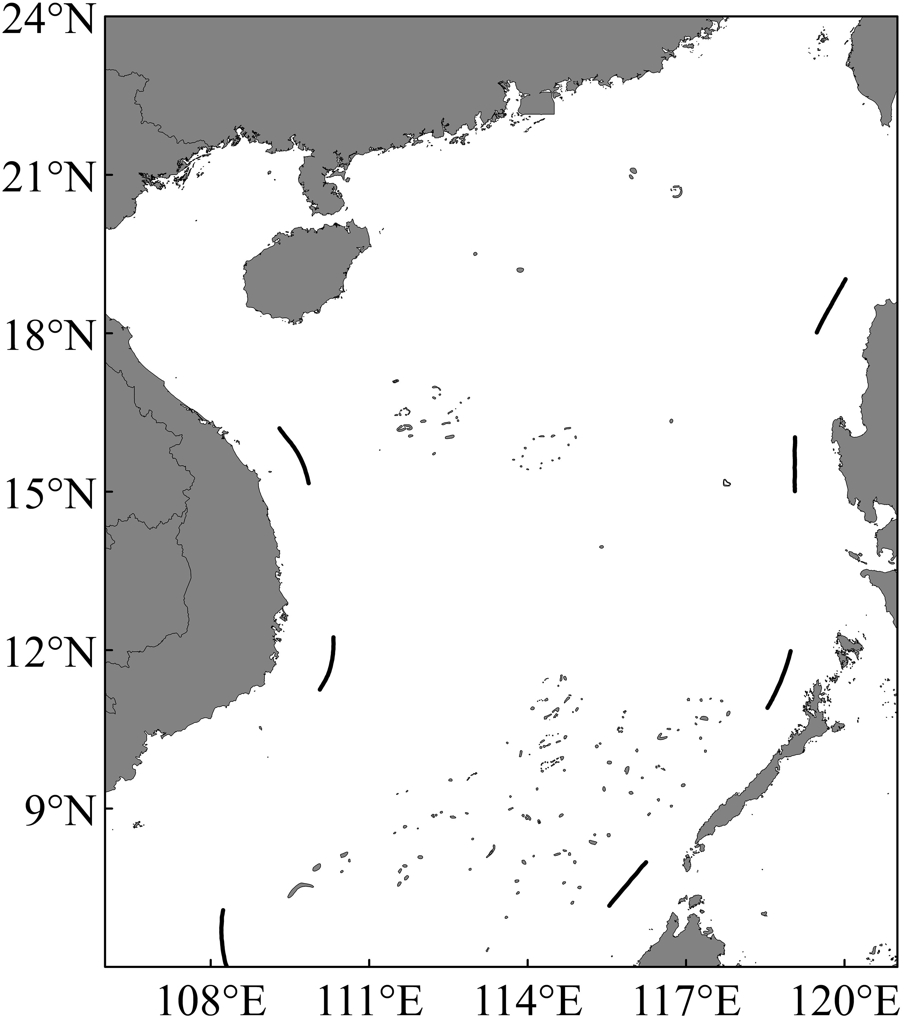
Figure 1 South China Sea waters.
We obtained the Beidou VMS data collected by the Strategy Research Center for the South China Sea Fisheries. The spatial resolution was approximately 10 m, and the temporal resolution was approximately 3 min. The dataset consisted of records for 121 large-size light falling-net fishing vessels in Guangxi, Guangdong, and Hainan (of which there were 55, 55, and 11 vessels in Guangxi, Hainan, and Guangdong, respectively) in the SCS from 2017 to 2020. The records included the names of the fishing vessels, positioning time, latitude and longitude, speed, heading, and other related information.
Preliminary processing of VMS data was required. First, after omitting any duplicate data, we excluded the vessel position data of fishing vessels operating outside the SCS (106°~121°E, 6~24°E). Second, we removed data from fishing vessels that had transmitted less than 1,000 messages of data over 1 month because this provides data points that are too few to be representative of the vessel’s behavioral characteristic. The fishing vessels sent many different discrete points during sailing and operation. Therefore, the speed and position of the vessels had to be changed during the month. We trimmed the datasets using the above thresholds. Using the cleaned-up data, we calculated the maximum number of fishing boats and operating days per month from 2017 to 2020.
In this study, we used Matlab 2016a to filter the timestamp, speed, latitude/longitude, and other information for 121 large-size light falling-net fishing vessels obtained from 2017 to 2020. If the data were within the preset range, the vessel data were marked as fishing operation points. Based on the operational characteristics of a large-size light falling-net fishing vessel, its main operation time is from after dark (around 19:00) to dawn (around 05:00 the next day), with no drifting (the speed is kept at 0-2 kn). Thus, a higher velocity of 3-8 kn during that time range ensures the vessel’s moving state. The location of each net operation may change, creating multiple discrete vessel locations (Xie et al., 2020). Excluding the first net, which requires a longer operation time, the net operation time for the other nets was < 30 min. Accordingly, we only chose those vessels with low speed (a vessel velocity of < 3 knots at 1:00 a.m-1:59 am) as fishing candidates and the fishing locations are calculated as the mean location. Besides, fishing vessels which operate for less than 5 days per month are removed to avoid contingencies. We used the mean center algorithm to calculate the fishing locations of the vessels in the SCS. The Equation is as follow (Zhou et al., 2021):
(x,y) represent the coordinates of the vessel’s fishing location, (xi,yi) represent the coordinates of the vessel’s discrete points.
We used Matlab 2016a to create 0.25°-resolution grids and estimated the mean numbers of fishing vessels in each grid cell by month and season.
The Beidou VMS datasets include the vessel name, latitude, longitude, and time. Fishing vessels generally send position information every 3 min. The province of the fishing vessel could be distinguished based on the vessel name. The vessel position points for each fishing vessel were sorted in chronological order. Multiple scattered points were connected to form a trajectory map of the fishing vessel. Finally, the trajectories of the fishing vessels were matched with the ports to determine the main ports from which the fishing vessels from different provinces enter or leave.
We mined and analyzed fishing vessel monitoring messages received by the target fishing vessels from 2017 to 2020 and extracted the fishing days of the vessels. Upon comparing the number of large-size light falling-net vessels (Figure 2) and the number of operating days (Figure 3) in the SCS by month from 2017 to 2020, we found that vessels operate in the SCS throughout the year. The period from March to May was the primary production season for large-size light falling-net vessels in the SCS. Position data were received from more than 78% ± 6.7% of the large-size light falling-net vessels, and the average number of fishing days per month exceeded 26.4 ( ± 2.5) d·vessel-1. From June to August, owing to the fishing moratorium in the SCS, the production of fishing vessels was affected. Position data were received from less than 50% of the vessels. Meanwhile, the mean monthly operation was 25.0 ( ± 1.3) d·vessel-1. The fishing moratorium ends before September, but the SCS has high winds and harsh operating conditions in the fall. Therefore, approximately 51.6% ± 1.7% of the vessels sent position data. The average monthly operation time was 27.4 ( ± 0.6) d·vessel-1. From December to February, approximately 53.7% of the large-size light falling-net vessels sent position data, and the average number of monthly fishing days was 23.5 ( ± 0.9) d·vessel-1.
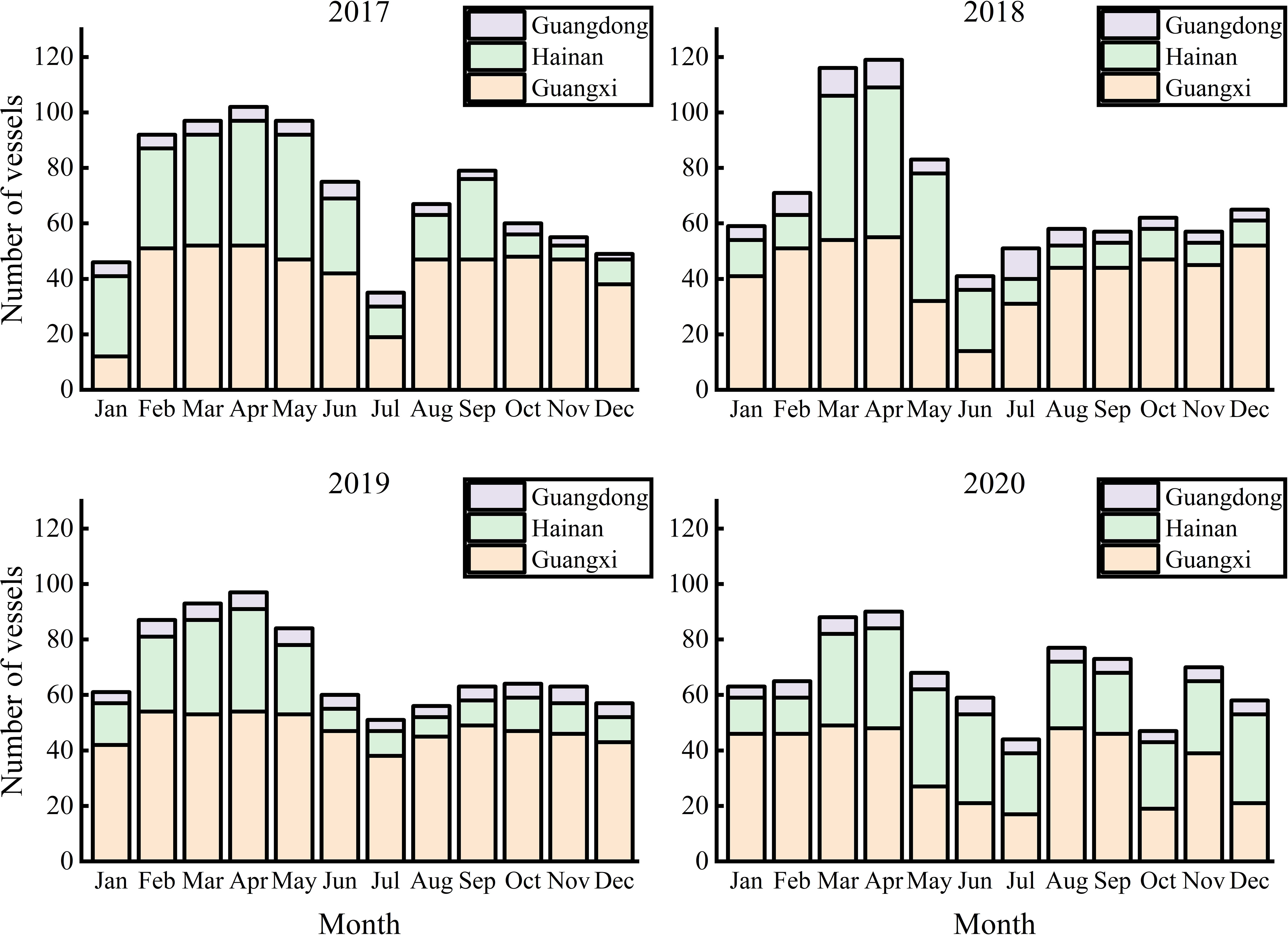
Figure 2 Monthly maximum numbers of fishing vessels obtained from vessel monitoring information.
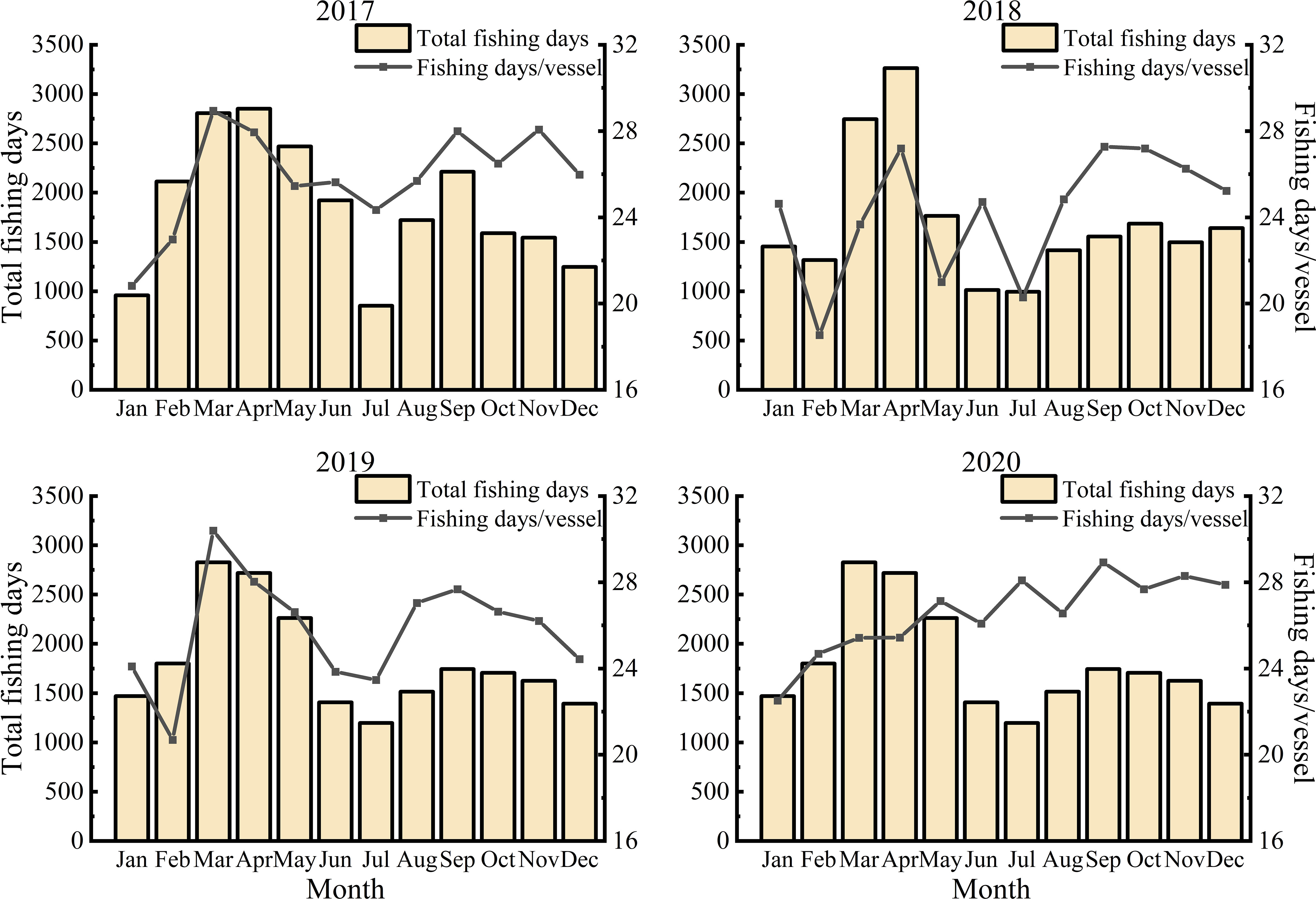
Figure 3 Average monthly operating days of fishing vessels from 2017 to 2020.
Given that the theoretical value of Beidou VMS time resolution is 3 min, each vessel can hypothetically transmit 480 position messages per day. Extracting and averaging the operational data of fishing vessels, we found that the actual values differed from the theoretical values (Figure 4). The VMS signal was transmitted at a lower frequency from May to July in 2018 and 2020. Also, the number of messages sent by fishing vessels differed from province to province (Figure 5). In 2017 and 2020, the Guangxi fishing vessels sent fewer VMS messages per day than the Guangdong fishing vessels. In 2018 and 2019, the Guangxi fishing vessels sent more VMS messages than the Guangdong fishing vessels. In contrast, the Hainan fishing vessels consistently sent the lowest number of VMS messages over the 4 years.
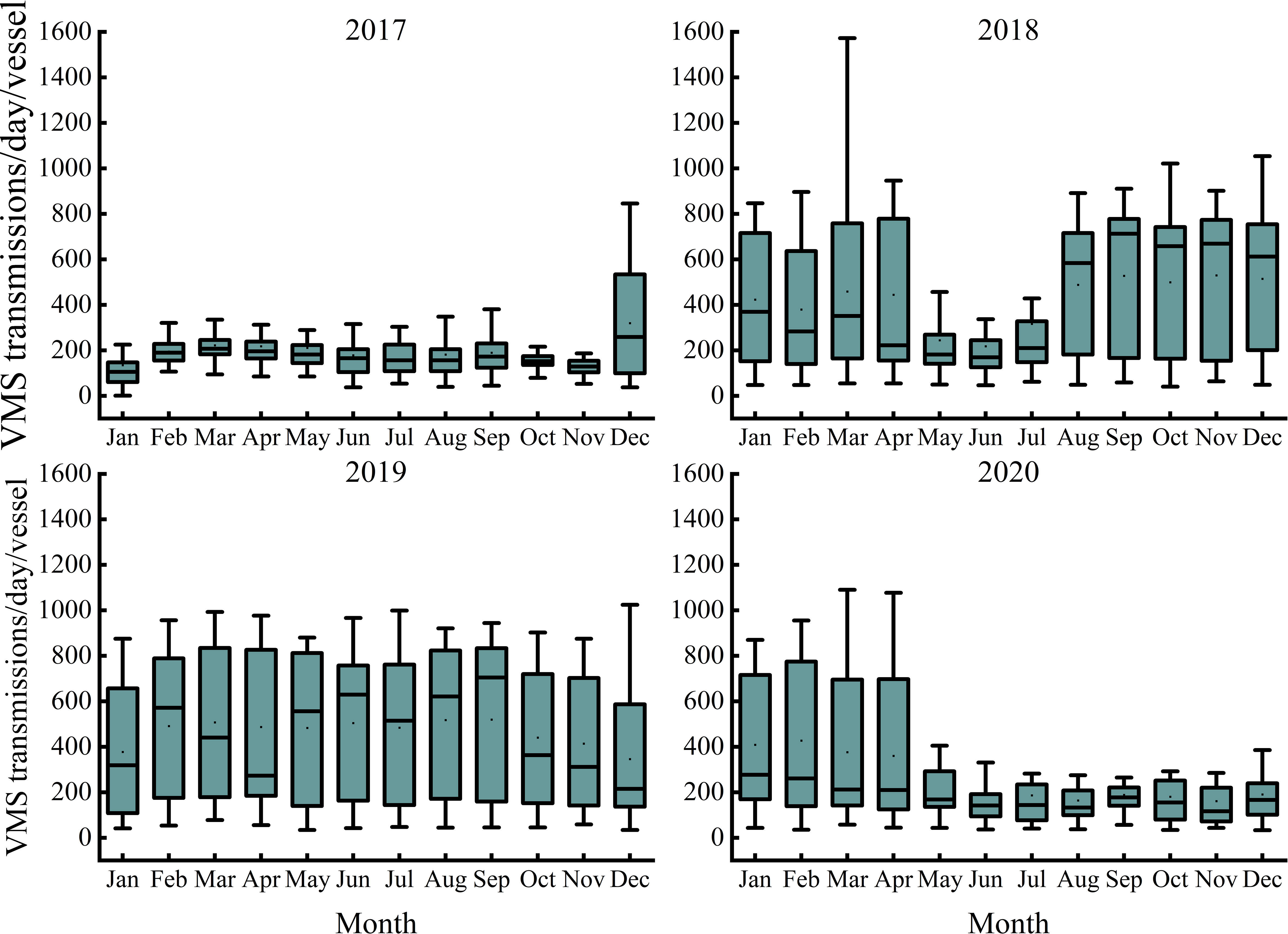
Figure 4 Average monthly numbers of Beidou vessel monitoring system transmissions per vessel per day in 2018.
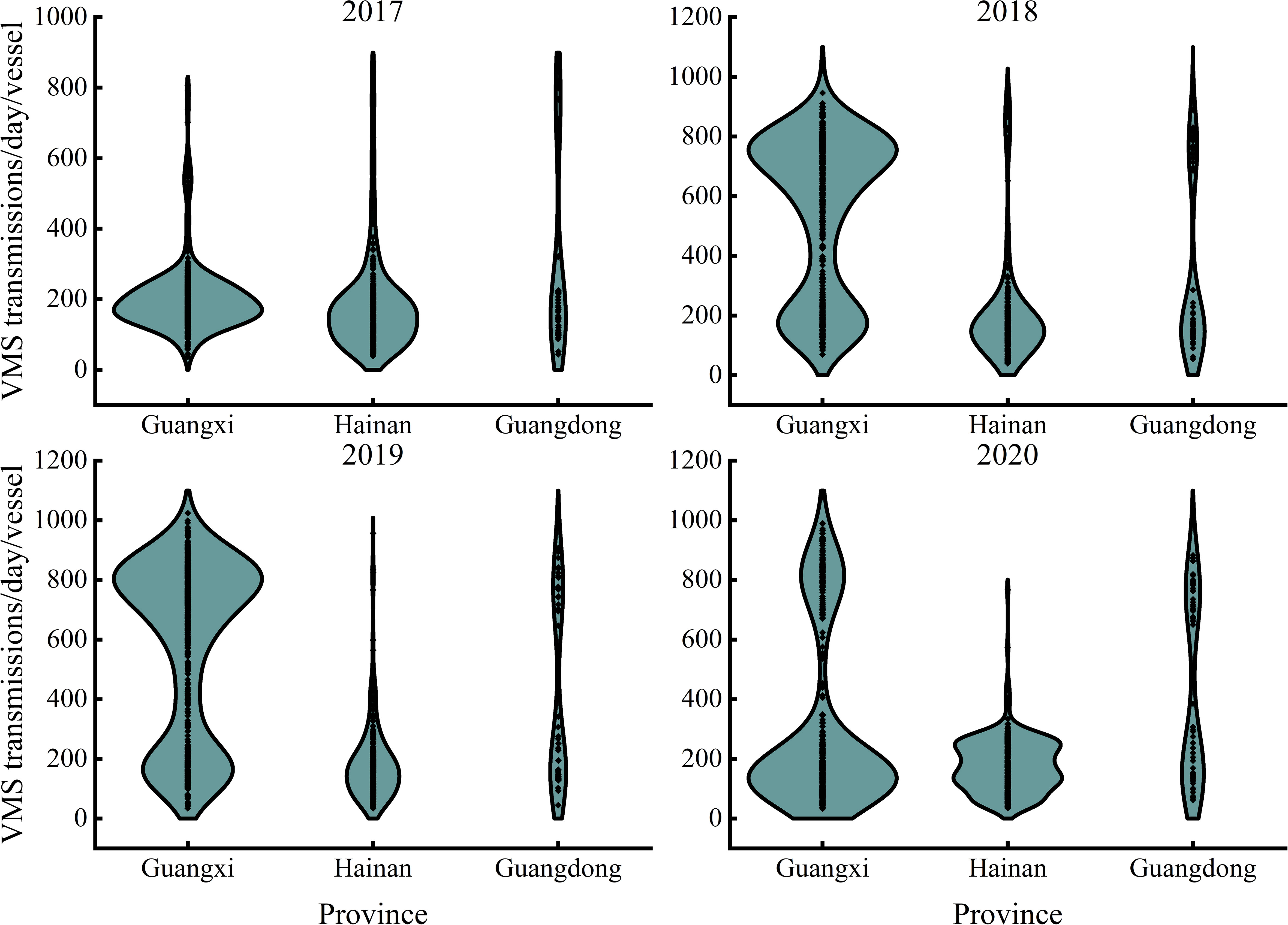
Figure 5 Average numbers of vessel monitoring system transmissions per vessel per day for the different provinces.
Based on the vessel position data of fishing vessels from 2017 to 2020, we drew the monthly distribution maps of vessels for different years. Figure 6A shows the spatial pattern of the average monthly operation distribution of large-size light falling-net vessels. There were few fishing vessels in January and February, and the operating location distribution was scattered. The fishing vessels were mainly in the Zhong and Xisha waters. From March to April, the fishing area of large-size light falling-net vessels in the SCS became the largest and was denser. At the same time, the fishing vessels began extending southward, reaching the waters near the Nansha Islands, and the operation area became more concentrated. From May to July, the number of fishing vessels and days decreased significantly. The location was also scattered. Then the number of fishing vessels started to increase in August, and the most of fishing vessels began to shift northward from the outer waters of the SCS. In September, they concentrated more around Wanshan, the waters of the Pearl River Estuary, and the waters of the Dongsha Islands. From October to December, fishing vessels were more concentrated in Beibu Gulf, and the waters of the Zhongsha and Xisha Islands. To further explore the characteristics of the position changes of large-size light falling-net vessels during fishing operations, the standard deviation distribution was plotted (Figure 6B). Clearly, the differences in the distribution of fishing vessels among 2017 to 2020 were small. The monthly operations of fishing vessels in the South China Sea exhibited some regularity.
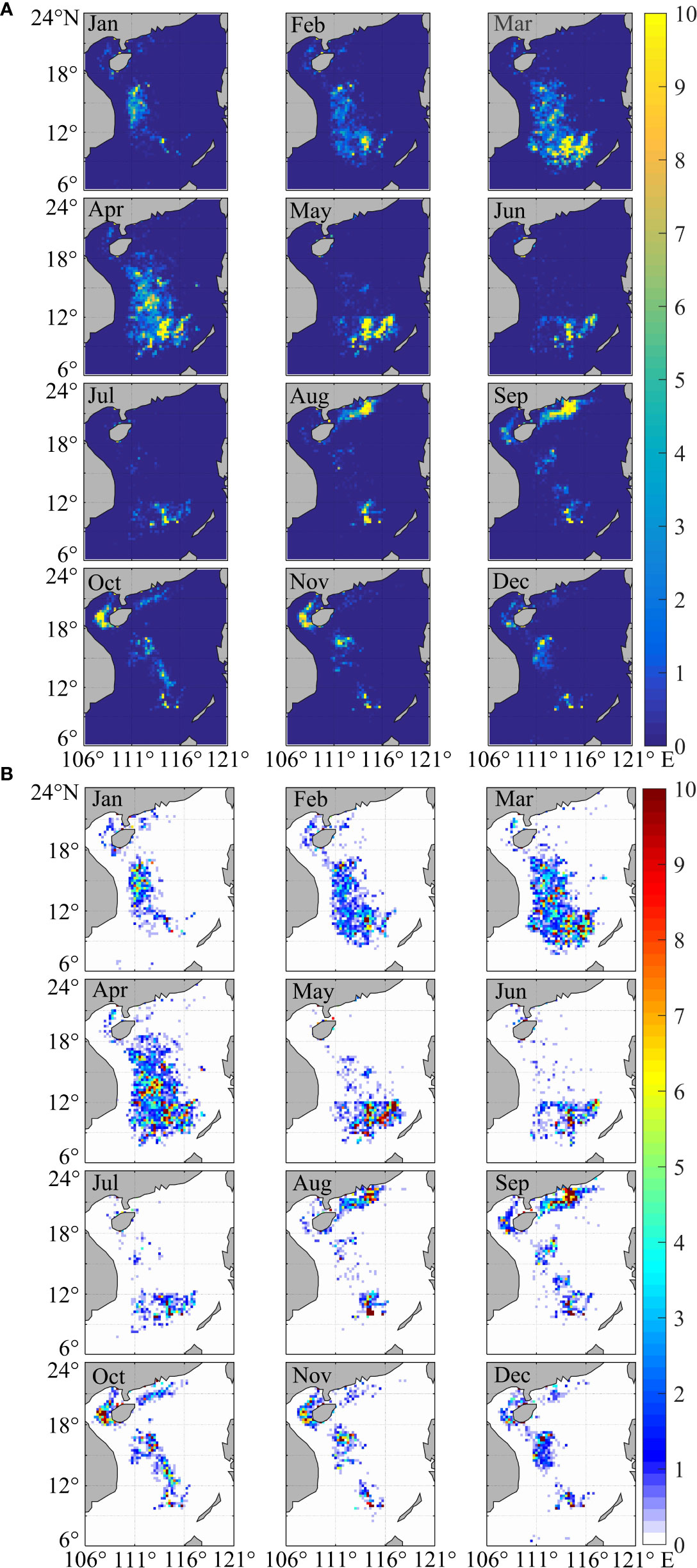
Figure 6 Monthly average distribution (A) and standard deviation distribution (B) of large-size light falling-net vessels in the South China Sea from 2017 to 2020.
We also analyzed the distribution of fishing vessels based on seasons. Most of the large-size light falling-net fishing vessels were in the Zhongsha, Xisha, and Nansha waters in the spring (Figure 7). Among the four seasons, spring had the maximum number of fishing vessels and the most extensive distribution. The number of fishing vessels operating in the summer decreased abruptly and was distributed mostly in two areas. The vessels were mainly in the waters south of 12°N and the Pearl River mouth. In autumn, the number of fishing vessels rebounded, and the distribution range changed. In addition to the Pearl River Estuary waters, vessels also started to fish in the Beibu Gulf waters. In the winter, the main operating area of fishing vessels changed to the Zhongsha and Xisha Island waters.
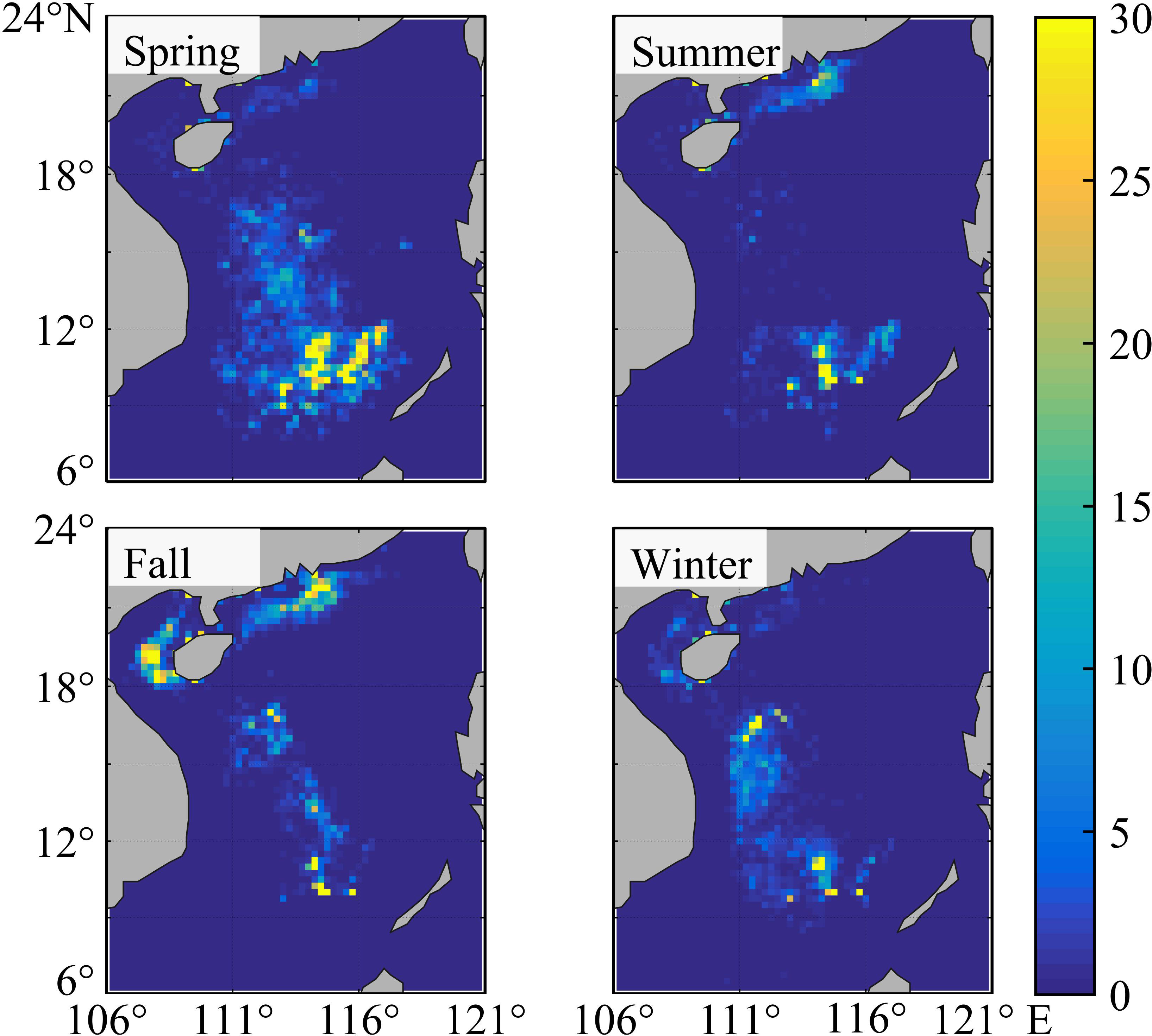
Figure 7 Seasonal distribution of large-size light falling-net vessels in the South China Sea.
We processed the target fishing vessel sailing locations by year and province (district) and then traced the records of these vessels and visualized their trajectory. We found distinctions in the positions of the fishing vessels among the different provinces (districts) (Figure 8). Guangxi fishing vessels were more widely distributed, with several key fishing areas throughout the year. Hainan fishing vessels were less spread out in the Pearl River waters and more spread out in the Zhongsha, Xisha, and Nansha waters. The Guangdong vessels rarely operated in the Beibu Gulf waters throughout the year, staying mainly in the Nansha Islands waters. Additionally, we tracked the trajectory of the fishing vessels throughout the year. The main ports of the fishing vessels are shown in Figure 9. Using the 2017–2020 vessel position data, we calculated the number of fishing vessels entering and leaving the ports. Fishing vessels from different provinces were in several different ports. For example, the fishing vessels of Guangxi were mainly concentrated in the Beihai, Zhapo, Yangpu, Dongfang, and Sanya ports. Of these, the largest proportion is in Beihai every year. Almost all the 55 fishing boats from Guangxi entered the Beihai port. The Zhapo and Yangpu ports also contained more than 45% of the fishing boats entering and leaving. For the fishing vessels of Hainan, the major ports were Sanya (56.3%) and Yazhou (68.0%). The fishing vessels from Guangzhou differed from the other two provinces in that their main ports were Guangzhou and Bohe.

Figure 8 Activity of 121 large-size light falling-net vessels according to the vessel monitoring system records. Shown are the distributions of fishing vessels from Guangxi (A), Hainan (B), and Guangdong (C).
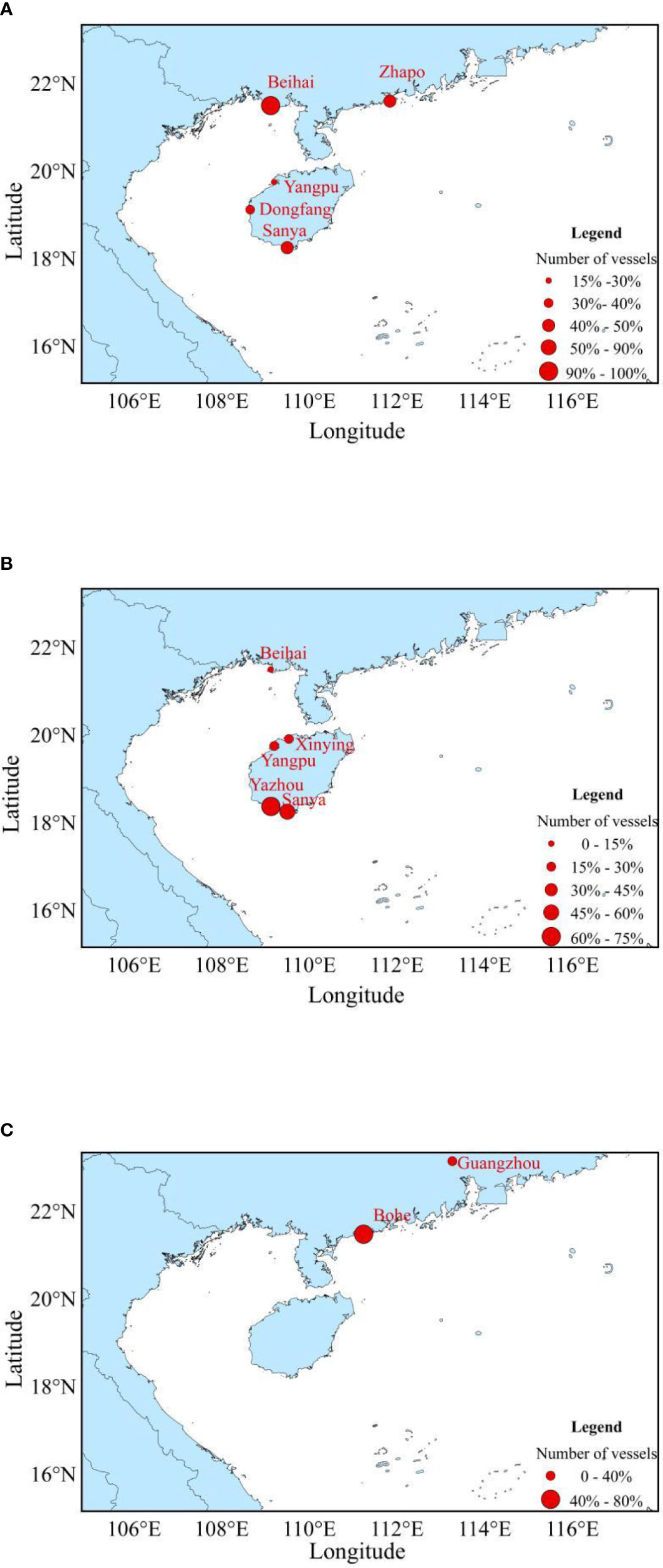
Figure 9 Trajectory of the large-size light falling-net vessels from vessel monitoring system records. Shown are the main ports for the fishing vessels of Guangxi (A), Hainan (B), and Guangdong (C).
Additionally, we conducted statistics on fishing vessels operating south of 12°N during the fishing moratorium by province (Figure 10). Our results indicate that the fishing vessels’ numbers, operating locations, and fishing days varied depending on the province of the fishing vessel. During the fishing ban, the number of fishing vessels belonging to Guangxi province operating south of 12°N was higher in 2017 and 2019. In 2018 and 2020, there were more fishing vessels from Hainan (Table 1).
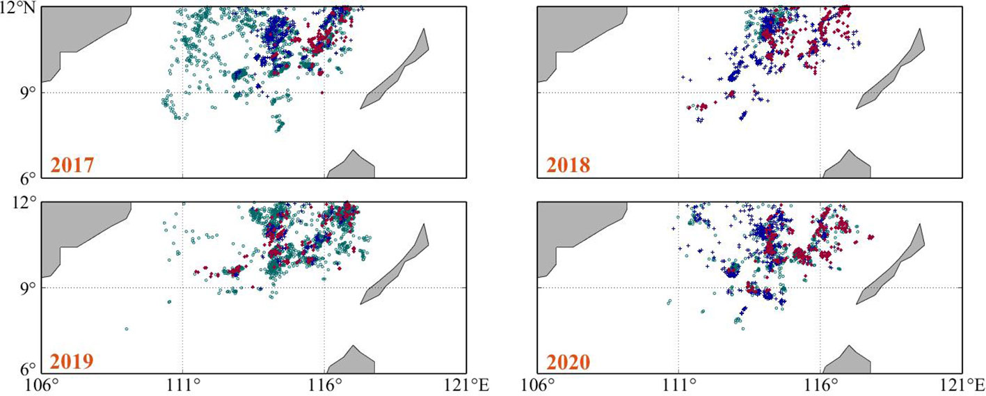
Figure 10 Distribution of fishing vessels in the area south of 12°N during the fishing moratorium.
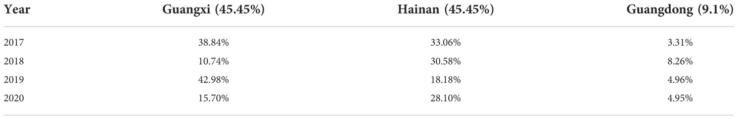
Table 1 The proportion of fishing vessels in different provinces during the fishing ban.
Comparing previous studies (Zhang et al., 2013), the distribution of the core fishing grounds for these vessels can be divided into four areas (Figure 11). I) 19°30′~23°N, 111°~116°E, outer continental shelf waters of the Pearl River Estuary; II) 19°~22°N, 106° ~110°E, the Beibu Gulf continental shelf sea area; III) 14°~19°N, 109°~116°E, near the Zhongsha and Xisha Islands waters; and IV: 4°~12°N, 109°30′~118°E, near the Nansha Islands waters. After the statistical screening of fishing days, a comparative graph was made for fishing vessels operating in the four fishing zones in different seasons from 2017 to 2020 (Figure 11). In the spring, vessels mainly operated in fishing areas III and IV, where the number of fishing days in fishing area IV was the maximum number of fishing days among the four fishing areas that year. In the spring of the four years, there were 3,454, 2,815, 4,676, and 3,439 fishing days in fishing area IV, respectively, and they accounted for 19.19%, 19.33%, 29.76%, and 16.82% of the total number of operating days over the entire year. By extension, this means that all of the fishing vessels operate in fishing area IV for over 45% of the entire fishing season. The number of fishing days in fishing area IV in the spring is >40% of the fishing days in fishing area IV throughout the year. The percentage was even up to approximately 60% from 2018 to 2019. In the summer, fishing vessels operate mainly in fishing area IV. Among the vessels, the number of fishing days in area IV in the summer of 2017 was 2,691, accounting for 14.95% of the total operating days. For 2018, 2019, and 2020, the numbers of fishing days in the summer in fishing area IV were 1,144, 1,598, and 1,989 days, respectively, which represent 7.86%, 10.17%, and 14.95% of the total operating days for the whole year. Additionally, the number of fishing vessels in fishing area I increased dramatically in August, creating two distinct fishing zones. In the autumn, there were differences in the distribution of fishing vessels. In addition to the main distribution areas of fishing areas I and II, fishing vessels were more distributed throughout fishing area III from 2018 to 2019 and fishing area IV in 2020. Among the vessels, the number of fishing days in area I in September continued to increase compared with August, accounting for almost 52.88 ( ± 7.92) % of the total number of fishing days in that month. Moreover, in October and November, there were two prominent fishing zones: fishing areas II and III. Fishing vessels operated in fishing area III for 1,299 and 1,602 days in the winter of 2017 and 2018, respectively. They accounted for 43.59% and 57.21% of the total number of fishing days in the whole season. In the winters of 2019 and 2020, fishing vessels operated in fishing area IV for 1,052 and 1,483 days, accounting for 39.11% and 33.22% of the total number of fishing days for the whole season.
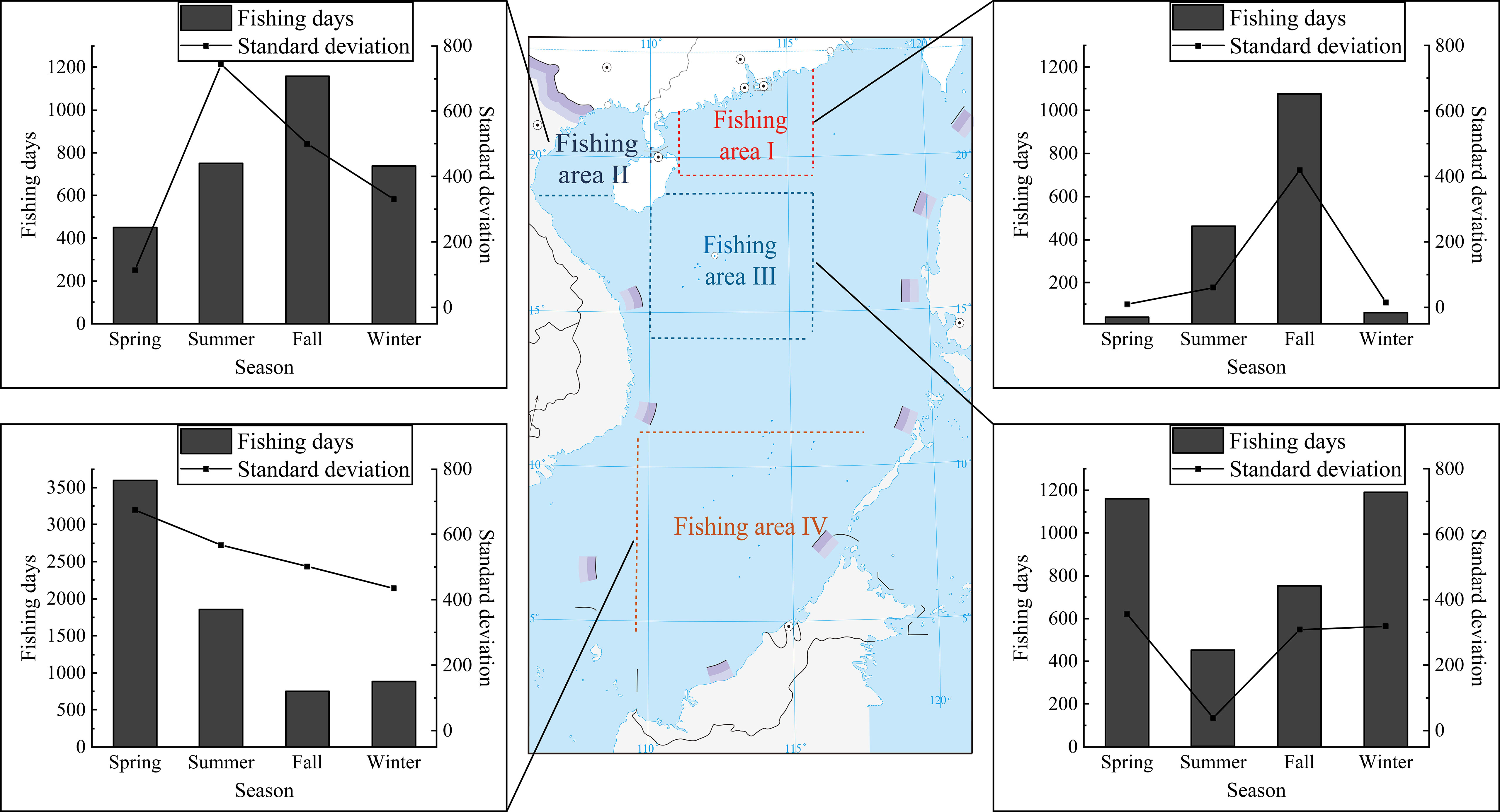
Figure 11 Delimitation of fishing zones and seasonal numbers of fishing days in different fishing zones.
Zhang Peng et al. (Zhang et al., 2013) found that from 2005 to 2010, the operating areas of the light falling-net fishing vessels were mainly in the deep-water areas near the Zhongsha and Xisha Islands, the outer continental shelf of the Pearl River Estuary, and the Beibu Gulf waters. In this study, we found that from 2017 to 2020, the operating area of the light falling-net fishing vessels expanded to the waters near the Nansha Islands. Compared with the fishing waters of fishing vessels from 2005 to 2010 (Table 2), the operating areas of the fishing vessels changed greatly throughout the different seasons. Additionally, the main operating season for light falling-net fishing vessels in the Zhong and Xisha waters has changed from spring to winter. The operating time in the sea area off the Pearl River Estuary changed from August to September and December to February (next year) to just August to September. Now the main operation area in spring is the Nansha Sea area. The number of fishing days in different areas throughout the year changed as well. We also found that the light falling-net fishing vessels’ material changed from wooden with outdated technical equipment to large steel fishing vessels. As the tonnage, sailing period, and wind resistance of fishing boats have all increased, the operating area of the light falling-net fishing vessel has also extended southward from the sea area closer to the port, and the number of fishing days has also increased. Owing to the increased pressure of offshore fishing and the decline of traditional fishery resources on the continental shelf, the fisherfolk in the northern part of the SCS need to find new outlets. Moreover, the Sthenoteuthis oualaniensis caught by large-size light falling-net vessels are in the deep-water areas of the south-central SCS. Thus, the area with the highest number of fishing days per year has changed from the continental shelf waters off the mouth of the Pearl River to the Nansha Islands waters.
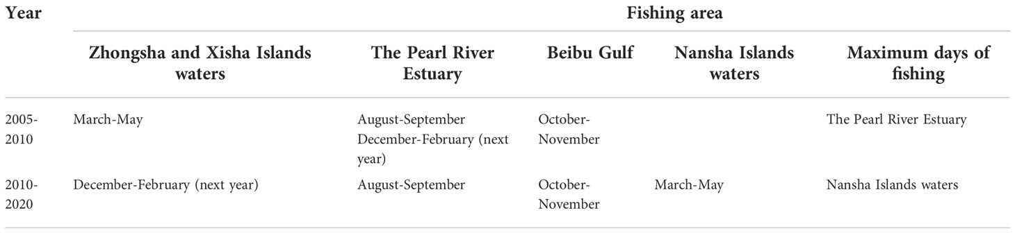
Table 2 A comparison of fishing area for large-size light falling-net vessels in the South China Sea.
In this study, we compared the distribution areas of fishing vessels in the SCS throughout the year and found that there were differences in the distribution of large-size light falling-net fishing vessels in various provinces (regions) of the SCS. We hypothesized that different fishing vessels have their regular fishing areas. Additionally, large-size light falling-net fishing vessels are affected by various factors including monsoons, typhoons, moratorium system, and traditional festivals such as Chinese New Year. The seasonal distribution pattern of fishing vessels can be identified to some extent by analyzing the spatial variation of large-size light falling-net fishing vessels throughout the year (Zhang, 2017). When comparing the number of operating days of large-size light falling-net fishing vessels from 2017 to 2020, the highest operating intensity of fishing vessels across all seasons was in the spring, followed by autumn, and the lowest was in the winter or summer. In the SCS, large-size falling-net vessels were mainly concentrated in the Zhongsha and Xisha Islands waters and extended southward to the sea areas near the Nansha Islands. Owing to the implementation of the fishing moratorium system (Ministry of Agriculture, 2018), summer is the low period of large-size light falling-net vessel operations, during which almost no fishing vessels operate in the SCS offshore from June to July. However, according to regulations from the Ministry of Agriculture of the PRC, fishing vessels with a special fishing permit for Nansha are allowed to travel to the Nansha waters south of 12°N to fish during the fishing moratorium. Thus, a small number of fishing vessels remain distributed off the SCS in June and July. At the end of the fishing moratorium, fishing vessels start to operate out of the harbor. Along with the outer SCS, there are also fishing vessels along the coast in August. Because fishing vessels operate in the area south of 12°N during the fishing moratorium, the vessels receiving a special permit need to be determined by lottery. The number of fishing vessels operating in this area varies slightly from year to year in different provinces. In the autumn, large-size light falling-net vessels in the SCS were affected by typhoons. The vessels began moving from the outer sea to the waters of the Pearl River Estuary, the waters near the Dongsha Islands, and the waters of the Beibu Gulf. Besides the summer, winter is the season with the least widespread of fishing vessels. Most fishing vessels operate in offshore waters or even cease production and rest in the harbor owing to the influence of cold air as well as high winds and waves at sea. During this period, the Spring Festival also slows down fishing boat operations. However, because the Chinese Spring Festival does not occur on a fixed date each year, there were annual variations in fishing days and zones between January and February.
In fact, in addition to the above factors, we can link the description of the spatial dynamics to the characteristics of the environment and of the stocks.
The main catches of large-size light falling-net fishing vessels include Sthenoteuthis oualaniensis and Auxis thazard. Relevant studies have shown that SST and SSH are important factors affecting fish growth, reproduction, and migration (Fan et al., 2015; Xie et al., 2020; Yan et al., 2021b). For example, when the sea surface height is higher than the average sea surface, the rich nutrients and bait of the bottom layer are continuously replenished upward, which in turn promotes the growth and reproduction of pelagic fishes.
SCS is affected by the southwest monsoon in summer (June-August), the southwest monsoon retreats from north to south in autumn (September-November), and the northeast monsoon in winter (December-February) (Ministry of Agriculture, 2018).
In addition, SCS is located in subtropical and tropical waters, with a wide variety of plankton and complex composition, suitable for fish growth (Shao and Chen, 2008). The phytoplankton region belongs to the single-peak seasonal variation type in SCS. It gradually rises from March, peaks in June, and then gradually declines, forming a yearly low from October to February. All of these factors can affect the distribution of fishing vessels.
In this study, we specifically compared the behavior of fishing vessels by province. They differed in terms of the sailing area, ports, and fishing. We considered that fishing vessels from different provinces are influenced by fishing policies, culture, and operating experience.
Currently, there are many modern methods for monitoring fishing vessels in the SCS, such as the Auto identity system (AIS), VMS, electronic monitoring (EM), synthetic aperture radar (SAR), and nightly satellites (Table 3). The main purpose of the AIS is to help prevent the collision of fishing boats and effectively guarantee the navigation safety of ships. It can be divided into Class A and Class B (Li et al., 2021). Presently, the AIS equipment installed by Chinese fishing vessels is Class B. Class B broadcasts at a lower frequency and has a shorter signal transmission distance than Class A. The efficiency of AIS with Class B equipment is extremely low where there are many ships. It is difficult to receive AIS signals in the outer waters of the SCS (Dhar, 2016). Thus, the AIS can barely be used on the near shore of the SCS and is not suitable for the outer sea. In China, the VMS was first applied in the SCS. It has high temporal resolution and wide coverage. From 2000 to the present, almost all fishing vessels in the SCS have been equipped with the VMS. The VMS transmits information through the Beidou satellite with high and stable data transmission quality. The EM is useful because it is easy to record, store, and search for data. But EMS relies on manual records to collect data, and there are cases where the reporting is false, and the data are not standardized. Data collection using the SAR has the characteristics of being all-day, all-weather, wide-range, and multi-parameter. The SAR images can accurately locate vessels through detailed images. Additionally, it is less affected by clouds and rain than the other methods. But it has only two daily imaging opportunities. The SAR processes and stores large amounts of data in ground stations. And there are limitations in signal coverage. Thus, the SAR is usually used mainly to monitor the fishing vessels in the SCS coastal areas. The SAR must be integrated with other methods to design and operate a real-time monitoring system for detecting and identifying the ships in the open SCS (Sudhir Kumar, 2019). Nightly satellites monitor large-size light falling-net fishing vessels by their lights (Li et al., 2021; Li et al., 2021). They can determine the vessel position and fishing intensity, as well as the spatial distribution and operation of fishing vessels. However, this method is unlikely to detect other gear types or vessels without bright lights, and it may be affected by factors such as moonlight and the presence of clouds.
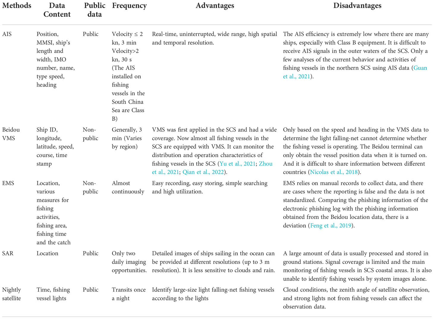
Table 3 A comparison of selected methods for vessel monitoring in the South China Sea.
Additionally, the VMS in the SCS transmits data through the Beidou satellite, which is characterized by improved confidentiality, higher accuracy, and wider range. Compared with the commonly used fishing log method, the Beidou VMS not only verifies the fishing operation location recorded in the fishing log, but it also achieves higher efficiency and lower manpower and material consumption (McCauley et al., 2016; Feng, 2020).
In addition to studying the spatial-temporal distribution of large-size light falling-net fisheries in the SCS, VMS can effectively obtain information on fishing intensity, analyze the impact of fishing activities on marine biological resources, and study fish stock distribution patterns. We can also use the VMS trajectory characteristics to classify fishing vessel navigation and fishing behavior, as well as quantitatively analyze the evolution of the fishing area of marine fisheries, which has important application value for the scientific development of marine fisheries.
Considering the factors influencing the information transmitted by the Beidou VMS is important for more accurate monitoring of the distribution of large-size light falling net fishing vessels. The Beidou terminal can only obtain vessel position data when it is turned on. If there are equipment failure, an insufficient power supply, a signal interference, or an artificial shutdown during the monitoring of fishing vessels, it will affect the monitoring results. Here, by comparing the VMS data of fishing vessels in three provinces, we found that there were differences in the frequency of data received in different provinces (districts). Therefore, fishing vessels are likely to be affected by the operating habits of the crew members and management style of the fishing vessels in different provinces (districts) when operating at sea (Zhang et al., 2021). According to Chinese relevant policies, besides the regular domestic oil price subsidies, there will be special oil price subsidies for fishing vessels operating in certain waters during their sailing operations in the waters south of 12°N. Thus, some fishing boats that are not operating in the SCS may open the Beidou VMS and pretend to work to receive subsidies. When fishing vessels are near the shore, they often use other more convenient and economical methods to transmit information such as Beidou short messages, satellite phones, and ultra-short waves (Guo, 2010; Li et al., 2020). The above reasons may make the Beidou VMS more efficient at recording messages in the Outer Sea area than in the nearshore area.
Only through the information of speed and heading of vessel position data cannot judge the operation of the light falling-net fishing vessels. In this study, we set thresholds to analyze fishing vessel operations via the operating characteristics of large-size light falling net fishing vessels. We reflected the vessel fishing days by the average number of data points recorded. If there is a problem with the Beidou terminal during operation, it may affect the statistics of the number of fishing vessels going to sea and the analysis of their location at sea. Yan et al. (2015) found that the moon phase significantly affected fishing vessel operations in the SCS with light falling-net vessels. Compared with the dark moon days (from the first to the seventh day of the first month and from the twenty-third to the thirtieth day of the first month), the production of fishing boats on the light moon days (from the eighth to the twenty-second day of the first month) will decrease, especially on the full-moon days (around the fifteenth day of the first month), and a few fishing vessels will not work. In this paper, we did not consider the fact that fishing vessels do not fish during the full moon. Therefore, using the number of days recorded by VMS as the number of fishing vessel operating days would be higher than the actual number of working days for fishing vessels.
In this study, we focused on large-size falling-net fishing vessels in the open SCS. First, using Beidou VMS data from 2017 to 2020, we found a seasonal pattern of change in the distribution of these vessels. The number of operating days for fishing vessels was the highest in the spring, followed by the autumn, and was relatively lower in the winter and summer. We also analyzed the distribution of fishing vessels in the SCS and found that it varies among the different provinces. As the seasons passed, we found that the most concentrated area of fishing vessel distribution shifted and that the main fishing areas and number of fishing days changed. Finally, we compared the VMS with other modern methods for monitoring fishing vessels and found that it is more feasible to study the large, falling-net fisheries in the SCS using the Beidou vessel position data. Using these data will provide more detailed scientific reference information for the SCS fisheries.
The original contributions presented in the study are included in the article/supplementary material. Further inquiries can be directed to the corresponding authors.
JQ: Conceptualization, Methodology, Formal analysis, Writing - review & editing, Software. JL: Conceptualization, Methodology, Funding acquisition, Resources, Writing - review & editing. KZ: Writing - review & editing. YQ: Conceptualization, Writing - review & editing, YC: Formal analysis, Writing - review & editing. QW: Funding acquisition, Resources. HT: Data Processing. SM: Funding acquisition, Resources. ZC: Conceptualization, Funding acquisition, Resources. All authors have read and agreed to the published version of the manuscript.
This work was supported by the Hainan Provincial Joint Project of Sanya Yazhou Bay Science and Technology City (2021JJLH0092), Key Research and Development Project of Guangdong Province (2020B1111030001), and the Central Public-interest Scientific Basal Research Fund, CAFS (2020TD05).
The authors declare that the research was conducted in the absence of any commercial or financial relationships that could be construed as a potential conflict of interest.
All claims expressed in this article are solely those of the authors and do not necessarily represent those of their affiliated organizations, or those of the publisher, the editors and the reviewers. Any product that may be evaluated in this article, or claim that may be made by its manufacturer, is not guaranteed or endorsed by the publisher.
Bastardie F., Nielsen J. R., Ulrich C., Egekvist J., Degel H. (2010). Detailed mapping of fishing effort and landings by coupling fishing logbooks with satellite-recorded vessel geo-location. J. Fisheries Res. 106 (1), 41–53. doi: 10.1016/j.fishres.2010.06.016
Cao S. J., Huang S. L., Guo W. L. (2002). Discussion on adopting the vessel monitoring system in Chinese fishery management. J. J. Shanghai Fisheries University 01), 89–93.
Dhar S. K. (2016). Addressing challenges with big data for maritime navigation: AIS data within the great lakes system (History, Computer Science: D. The University of Toledo).
Fan J. T., Zhang J., Feng X., Chen Z. Z. (2015). Fishery forecast research of purpleback flying squid in nansha area based on habitat mode. J. South China Fisheries Sci. 11 (5), 20–26. doi: 10.3969/j.issn.2095-0780.2015.05.003
Feng F. (2020). Current status analysis of marine fishery resources carrying capacity in guangdong province based on electronic fishing logs (D. Tianjin: Tianjin Agricultural University).
Feng B., Yan Y. R., Zhang Y. M., Yi M. R., Lu H. S. (2014). A new method to assess the population of Sthenoteuthis oualaniensis in the south China Sea. J. Prog. In Fishery Sci. 35 (04), 1‒6. doi: 10.11758/yykxjz.20140401
Feng F., Zhou Y. B., Chen S., Xie E. G., Wu Q. E. (2019). Comparative study on credibility of fishing information of electronic fishing logs of trawlers and fishing information acquired by beidou position data. J. South China Fisheries Science 15 (06), 65–74. doi: 10.12131/20190110
Guan Y. N., Zhang J., Zhang X., Li Z. W., Meng J. M., Liu G. W., et al. (2021). Identification of fishing vessel types and analysis of seasonal activities in the northern south China Sea based on AIS data: A case study of 2018. J. Remote Sensing 13, 1952. doi: 10.3390/RS13101952
Guo Y. (2010). Boosting to fishery economy and management by satellite navigation and information-based communication. J. Chin. Fisheries Economics 28 (03), 37–42.
Jennings S., Lee J. (2012). Defining fishing grounds with vessel monitoring system data. J. ICES J. Mar. Science 69 (1), 51–63. doi: 10.1093/icesjms/fsr173
Jiang M., Ma S. W., Ma Z. H., Zou J. W., Wu S. S., Lin F. H., et al. (2018). Economic benefit analysis of trawlers and light trap and falling net fishing vessels in south China Sea. J. Insights Aquaculture Biotechnol. 2 (1), 5.
Jin X. S., Dou S. Z., Shan X. J., Wang Z. Y., Wan R. J., Bian X. D. (2015). Hot spots of frontiers in the research of sustainable yield of Chinese inshore fishery. J. Prog. In Fishery Sci. 36 (01), 124–131. doi: 10.11758/yykxjz.20150119
Lambert G. I., Jennings S., Hiddink J. G., Hintzen N. T., Hinz H., Michel J. K., et al. (2012). Implications of using alternative methods of vessel monitoring system (VMS) data analysis to describe fishing activities and impacts. J. Ices J. Mar. Science 69 (4), 682‒693. doi: 10.1093/icesjms/fss018
Li J. J., Cai Y. C., Zhang P., Jing Z. Y., Wu Q. E., Qiu Y. S., et al. (2021). Satellite observation of a newly developed light-fishing “hotspot” in the open south China Sea. J. Remote Sens. Environment 256 (6), 112312. doi: 10.1016/j.rse.2021.112312
Li B., Chen G. B., Guo Y., Chen Z. Z., Zhang J., Wang D. X. (2016). Hydroacoustic assessment of spatial-temporal distribution and biomass of fishery resources in the central south China Sea. J. South China Fisheries Science 12 (4), 28–37. doi: 10.3969/j.issn.2095-0780.2016.04.004
Li A., Xu S., Wang Y., Wang Z. Z., Guo Y. D. (2020). Research on the application of fishery ultrashort wave shore platform coverage prediction. J. China Water Transport. 20 (01), 73–74.
Li J. J., Zhang P., Cai Y. C., Zhang Q. L., Zhang K., Jing Z. Y., et al. (2021). Performance of VMS and nightly satellite in monitoring light fishing vessels in the open south China Sea. J. Fisheries Res. 243, 106100. doi: 10.1016/j.fishres.2021.106100
Li X. E., Zhou L., Xiao Y., Wu W. Z., Su F. Z., Shi W. (2021). Spatial characteristics mining of fishing intensity in the northern south China Sea based on fishing vessels AIS data. J. J. Geo-Information Science 23 (05), 850‒859. doi: 10.12082/dqxxkx.2021.200328
McCauley D. J., Woods P., Sullivan B., Bergman B., Jablonicky C., Roan A., et al. (2016). Ending hide and seek at sea. J. Science 351 (6278), 1148‒1150.
Mills C. M., Townsend S. E., Jennings S., Eastwood P. D., Houghton C. A. (2007). Estimating high resolution trawl fishing effort from satellite-based vessel monitoring system data. J. ICES J. Mar. Science 64, 248–255. doi: 10.1093/icesjms/fsl026
Ministry of Agriculture (2018). Circular of the ministry of agriculture on adjusting the marine summer fishing moratorium system. J. Bull. Ministry Agric. Rural Affairs PRC 03), 54.
Nicolas L., Guillaume H., Romy A., Romain de J., Béatrice N., Marzuki M. I., et al. (2018). Completing fishing monitoring with spaceborne vessel detection system (VDS) and automatic identification system (AIS) to assess illegal fishing in Indonesia. J. Mar. Pollut. Bull. 131 (Pt B), 33–39. doi: 10.1016/j.marpolbul.2017.10.016
Qian J., Li J. J., Chen Z. Z., Ma S. W., Zhang P., Qiu Y. S., et al. (2022). An investigation of large-size light falling-net fishing vessels operating in south China Sea based on beidou VMS data. J. South China Fisheries Sci 18 (6), 1. doi: 10.12131/20220001
Rocio J., Omar S., Mariano G., Ronan F., Sophie B. (2015). Defining fishing spatial strategies from VMS data: Insights from the world’s largest monospecific fishery. J. Fisheries Res. 164, 223‒230. doi: 10.1016/j.fishres.2014.12.004
Shao F., Chen X. J. (2008). Relationship between fishing ground of symlectoteuthis oualaniensis and sea surface height in the northwest Indian ocean. J. Mar. Sci. 32 (11), 88–92.
Su L., Chen Z. Z., Zhang P., Li J., Wang H. H., Huang J. X. (2018). Catch composition and spatial-temporal distribution of catch rate of light falling-net fishing in central and southern south China Sea fishing ground in 2017. J. South China Fisheries Science 14 (05), 11‒20. doi: 10.3969/j.issn.2095-0780.2018.05.002
Sudhir Kumar C. (2019). Study of synthetic aperture radar and automatic identification system for ship target detection. J. J. Ocean Eng. Science 4, 173–182. doi: 10.1016/j.joes.2019.04.002
Tang X. F., Zhang S. M., Fan W., Pei K. Y. (2020). Voyage analysis of jiangsu fishing vessels based on beidou position data. J. Fishery Modernization 47 (01), 63‒71.
Wei P., Wang X. H., Ma S. W., Zhou Y. B., Huang Y. B., Su Y. J., et al. (2019). Analysis of current status of marine fishing in the south China Sea. J. J. Shanghai Ocean University 28 (06), 976‒982. doi: 10.12024/jsou.201280902393
Xie E. G., Wu Q. E., Zhou Y. B., Zhang S. M., Feng F. (2020). Extraction and verification of operational state characteristics of light shield net vessels based on beidou vessel position data. J. J. Shanghai Ocean University 29 (3), 392‒400. doi: 10.12024/jsou.20190602714
Xie E. G., Zhou Y. B., Feng F., Wu Q. E. (2020). Catch per unit effort (CPUE) standardization of purpleback flying squid sthenoteuthis oualaniensis for Chinese large-scale lighting net fishery in the open sea of south China Sea. J. J. Dalian Fisheries University 35 (03), 439‒446. doi: 10.16535/j.cnki.dlhyxb.2019-122
Yan Y. R., Feng B., Lu H. S. (2009). Comparative analysis on fishing capability of two light attracting commercial fishing methods around zhongsha and xisha islands sea areas, south China Sea. J. South China Fisheries Science 5 (06), 59‒64. doi: 10.3969/j.issn.1673-2227.2009.06.011
Yang L., Lu H. S., Wu Z., Zhang X. F., Yan Y. R., Liu G. M., et al. (2002). Marine fishing gear and fishing method in the south China Sea (Guangzhou: Guangdong Science & Technology Press).
Yang L., Zhang P., Zhang X. F., Tan Y. G. (2002). Main problems for development of marine fishing gears in the south China Sea. J. Fishery Inf. Strategy 11), 7‒10.
Yan L., Li J., Zhang P., Yang B. Z., Wang T. (2021a). Effects of spatiotemporal and environmental factors on the fishing ground of Sthenoteuthis oualaniensis in the south China Sea based on the generalized additive model. J. Mar. Sci. Bulletin 40 (2), 217–224. doi: 10.11840/j.issn.1001-6392.2021.02.011
Yan L., Li J., Zhang P., Yang B. Z., Wang T. (2021b). Effects of spatiotemporal and environmental factors on the fishing ground of Sthenoteuthis oualaniensis in the south China Sea based on the generalized additive model. J. Mar. Sci. Bulletin 40 (02), 217‒223. doi: 10.11840/j.issn.1001-6392.2021.02.011
Yan L., Zhang P., Yang L., Yang B. Z., Chen S., Li Y. N., et al. (2015). Effect of moon phase on fishing rate by light falling-net fishing vessels of Symplectoteuthis oualaniensis in the south China Sea. J. South China Fisheries Science 11 (03), 16‒21. doi: 10.3969/j.issn.2095-0780.2015.03.003
Yan L., Zhang P., Yang L., Yang B. Z., Tan Y. G. (2014). Catch composition of light falling-net fishery in the central and southern south China Sea in spring of 2011. J. South China Fisheries Science 10 (03), 97‒103.
Yu J., Zhou Y. B., Tang Z. C., Chen G. B., Zeng L. (2021). Fishing characteristics of double trawler using vessel monitoring system data. J. Mar. Sci. 45 (10), 40‒48. doi: 10.11759/hykx20200825001
Zhang S. Y. (2017). Research on fishing dynamic changes in the south China Sea using nighttime light data (D. Nanjing: Nanjing University).
Zhang R. H. (2020). A study on fishing behavior of drift gillnet vessels in China based on big data on vessel positions (D. Shanghai: Shanghai Ocean University).
Zhang S. M., Fan W., Zhang H., Yang S. L., Tang F. H., Zhu W. B. (2018). Dynamic monitoring and analysis of number of fishing vessel voyages in hainan province based on beidou position data. J. South China Fisheries Science 14 (05), 1‒10. doi: 10.3969/j.issn.2095-0780.2018.05.001
Zhang K., Liao B. C., Xu Y. W., Zhang J., Sun M. S., Qiu Y. S., et al. (2017). Assessment for allowable catch of fishery resources in the south China Sea based on statistical data. J. Haiyang Xuebao 39 (08), 25‒33. doi: 10.3969/j.issn.0253-4193.2017.08.003
Zhang L., Li Y., Lin L. S., Yao Z., Yan L., Zhang P. (2016). Fishery resources acoustic assessment of major economic species in south-central of the south China Sea. J. Mar. Fisheries 38 (6), 577–587. doi: 10.13233/j.cnki.mar.fish.2016.06.003
Zhang S. M., Pei K. Y., Wu Z. L., Chen T. F., Fan W., Zhu W. B. (2021). Quantitative analysis of cruise duration and range of Chinese fishing vessels based on VMS. J. J. Shanghai Ocean University 30 (02), 311‒319. doi: 10.12024/jsou.20191102856
Zhang J., Qiu Y. S., Chen Z. Z., Zhang P., Zhang K., Fan J. T., et al. (2018). Advances in pelagic fishery resources survey and assessment in open south China Sea. J. South China Fisheries Science 14 (006), 118–127. doi: 10.12131/20180037
Zhang S. M., Tang F. H., Zhang H., Fan W., Huang H. W. (2014). Research on trawling tracing based on beidou vessel monitoring system data. J. South China Fisheries Science 10 (3), 15–23. doi: 10.3969/j.issn.2095-0780.2014.03.003
Zhang H., Wu Z. L., Zhou W. F., Jin S. F., Zhang P., Yan L., et al. (2016). Species composition, catch rate and occurrence peak time of Thunnidae family in the fishing ground of light falling-net fisheries in the nansha islands area of the south China Sea. J. Mar. Fisheries 38 (2), 140–148. doi: 10.13233/j.cnki.mar.fish.2016.02.004
Zhang S. M., Yang S. L., Dai Y., Fan W., Huang H. W. (2014). Algorithm of fishing effort extraction in trawling based on beidou vessel monitoring system data. J. J. Fisheries China 38 (8), 1190–1199. doi: 10.3724/SP.J.1231.2014.49135
Zhang P., Zeng X. G., Yang L., Peng C. H., Zhang X. F., Yang S., et al. (2013). Analyses on fishing ground and catch composition of large-scale light falling-net fisheries in south China Sea. J. South China Fisheries Science 9 (03), 74‒79.
Zhang R. H., Zhang S. M., Chen X. Z., Fan W., Zhu W. B. (2019). Research on extract floating gill net hauls and direction based on beidou data. J. Mar. Fisheries 41 (2), 169‒178. doi: 10.13233/j.cnki.mar.fish.2019.02.005
Zhang P., Zhang J., Li Y., Zhang R., Lin L. S., Yan L., et al. (2016). An exploratory fishing survey of light falling-net fisheries in the central and southern south China Sea in autumn. J. South China Fisheries Science 12 (2), 67–74. doi: 10.3969/j.issn.2095-0780.2016.02.010
Zhang S. M., Zhang H., Tang F. H., Fan W., Huang H. W. (2016). Method of extracting trawling effort based on vessel monitoring system. J. Mar. Sci. 40 (3), 146–153. doi: 10.11759/hykx20140217002
Zheng L. B., Ding T. M., Ai W. Z., Lou R. M. (2019). Application and countermeasures of beidou satellite navigation system in vessels. J. Shipping Manage. 41 (10), 31–34. doi: 10.13340/j.jsm.2019.10.011
Zheng T., Tang Y. (2016). Analysis of current status of Chinese marine fishing fleet of south China Sea area. J. J. Shanghai Ocean Univ. 25 (04), 620‒627. doi: 10.12024/jsou.20160201650
Zhou Y. B., Xie E. G., Wu Q. E., Feng F. (2021). The relationship between the resources of Sthenoteuthis oualaniensis in the open south China Sea and the marine environment. J. Acta Oceanologica Sinica 43 (02), 38‒48. doi: 10.12284/hyzb2021008
Zou J. W., Chen L. F., Lin J. J., Lu Z. F., Yang B. H. (2014). Analysis on variation and distribution of central fishing ground for light falling-net in offshore of the south China Sea based on statistics of fishery surveillance to guangxi fishing vessels. J. South China Fisheries Science 10 (04), 78‒84. doi: 10.3969/j.issn.2095-0780.2014.04.013
Keywords: Beidou VMS, vessel position data, large-size light falling-net fishery, South China Sea, fishing area
Citation: Qian J, Li J, Zhang K, Qiu Y, Cai Y, Wu Q, Tian H, Ma S and Chen Z (2022) Spatial–temporal distribution of large-size light falling-net fisheries in the South China Sea. Front. Mar. Sci. 9:1075855. doi: 10.3389/fmars.2022.1075855
Received: 21 October 2022; Accepted: 17 November 2022;
Published: 02 December 2022.
Edited by:
Xi Xiao, Zhejiang University, ChinaReviewed by:
Xiujuan Shan, Yellow Sea Fisheries Research Institute (CAFS), ChinaCopyright © 2022 Qian, Li, Zhang, Qiu, Cai, Wu, Tian, Ma and Chen. This is an open-access article distributed under the terms of the Creative Commons Attribution License (CC BY). The use, distribution or reproduction in other forums is permitted, provided the original author(s) and the copyright owner(s) are credited and that the original publication in this journal is cited, in accordance with accepted academic practice. No use, distribution or reproduction is permitted which does not comply with these terms.
*Correspondence: Zuozhi Chen, Y2hlbnp1b3poaUBzY3NmcmkuYWMuY24=; Shengwei Ma, bWFzaGVuZ3dlaUBzY3NmcmkuYWMuY24=
†These authors have contributed equally to this work and share first authorship
Disclaimer: All claims expressed in this article are solely those of the authors and do not necessarily represent those of their affiliated organizations, or those of the publisher, the editors and the reviewers. Any product that may be evaluated in this article or claim that may be made by its manufacturer is not guaranteed or endorsed by the publisher.
Research integrity at Frontiers
Learn more about the work of our research integrity team to safeguard the quality of each article we publish.