 Giandomenico Foti
 Giuseppe Barbaro
 Felice D’Alessandro
- 1Mediterranea University of Reggio Calabria, Civil, Energy, Environmental and Material Engineering (DICEAM) Department, Reggio Calabria, Italy
- 2University of Milan, Department of Environmental Science and Policy, Milan, Italy
Editorial on the Research Topic:
Innovations in coastal erosion risk assessment and mitigation
Introduction
This Research Topic focused on coastal erosion risk. This is a current and important topic as it involves many of the world’s coastal areas (Luijendijk et al., 2018; Mentaschi et al., 2018). Generally, coastal erosion is caused by an alteration of coastal and river dynamics both due to the action of natural factors and to the increase in anthropogenic pressure (Besset et al., 2019; Bombino et al., 2022), mainly observed in the second half of the last century after the end of the Second World War (Ozpolat and Demir, 2019). All of this influences the shoreline position, which is the most important geoindicator of shoreline evolution (Boak and Turner, 2005). From this point of view, remote sensing and GIS (Geographical Information Systems) techniques allow us to accurately identify the shoreline position and to estimate the shoreline changes over the years (Moore, 2000; Apostolopoulos and Nikolakopoulos, 2021; Boumboulis et al., 2021). Furthermore, anthropogenic pressure causes an increase in impermeable surfaces with negative consequences on the vulnerability of the territory under the action of natural events such as floods and sea storms (Fiori et al., 2014). Climate change can also contribute to coastal erosion by the increasing of sea levels and of frequency and intensity of extreme weather events (Yang et al., 2015; Mavromatidi et al., 2018).
Due to the various issue of this topic, to protect and manage coastal areas all the natural and anthropogenic factors that influence coastal and river dynamics should be analyzed. From this point of view, many coastal erosion risk assessment methodologies have been defined. These methodologies differ from each other mainly about the large differences in the factors analyzed by each methodology, depending by the coastal regions analyzed, and about the scale of application (Narra et al., 2017; Pantusa et al., 2018; Viavattene et al., 2018).
Research topic summary
Eleven papers have been published in this Research Topic, ten of which are Original Research and the other are a Perspective paper. Below is a summary of the main objectives of each paper.
Many papers have focused on shoreline changes, especially in vulnerable coastal regions. Among these, Bushra et al. (2021) analyzed the coast of Kuakata, in south-central Bangladesh, Foti et al. (2022) analyzed the coast of Calabria, a region in southern Italy, and Luijendijk et al. (2022) analyzed the coast of Saudi Arabia. In all the papers remote sensing and GIS techniques have been widely used and the causes of the shoreline erosive phenomena were analyzed. In addition, the first paper used participatory rural appraisal (PRA) tools which revealed the societal impacts caused by the shoreline changes. Instead, the second paper proposed a classification of erosive trends at different time scales, based on a shoreline variation rate while the third paper evaluate the future shoreline changes due to sea level rise under a moderate emissions scenario, RCP 4.5, and a high emissions scenario, RCP 8.5. Vulnerability to coastal erosion was analyzed by Cao et al. (2022) in 15 counties and districts along the coast of the Pearl River Estuary Great Bay Area. This study selects 12 evaluation indices from five perspectives for analysis, including coastal characteristics, hydrodynamic forces, economics, population, and coastal reconstruction. Also, this study used analytic hierarchy process (AHP) method, Technique for Order Preference by Similarity to an Ideal Solution (TOPSIS) method, independent weight method, Jenks natural breaks method (Jenks), exposure-sensitivity-adaptation (ESA) model and obstacle degree method to construct a coastal erosion vulnerability evaluation system for the study area.
Other papers have focused on the effects of sea storms and extreme events such as typhoons. Among these, Kim et al. (2021) provided a vulnerability analysis of beach erosion along the east coast of South Korea with few tidal ranges. This analysis was carried out through a beach vulnerability curve (BVC) by applying a storm wave scenario, function of the peak wave height, to a shoreline response model (SLRM) of bulk model type. The performance of the BVC was tested by comparison with long-term shoreline observation data and showed good agreement under high wave conditions, which is more meaningful for vulnerability analysis. Instead, Do et al. (2022) carried out a numerical simulation, using Telemac-2D and XBeach, of the dune erosion due to Typhoon Tapah occurred in Boggil Beach, Korea, in September 2019. Furthermore, these models were also used to evaluate the effects of measure to preserve the beach from future storm attacks, such as submerged breakwater and submerged groin.
Among other papers, Sauvé et al. (2022) used a multicriteria decision analysis (MCDA) approach through PROMETHEE method to evaluate and hierarchize coastal defense measures (CDMs) in four study sites in the province of Quebec, Canada, with distinct geomorphological, hydrodynamic, ecological, and socio-economic characteristics. Mendoza et al. (2022) proposed a Coastal Resilience Index from Remote Sensors (CRIfRS) for an urbanized coast of the Northern Yucatan coast. This index was divided into five categories, was based on aerial photogrammetry, was applicable on regional and local scale and depends on three indicators: beach width, coastal structure influence area, and vegetation coverage. Chen et al. (2021) analyzed the erosion threshold of sand-mud mixtures through a theoretical analysis of the momentum balance of a sand particle or a mud parcel under the initial motion condition and developed a formula for the critical shear stress of sand-mud mixtures, which also applies for pure sand and mud. Compared with the existing formulae for sand-mud mixtures, the developed formula is much easier for application as it has few coefficients. Zhang et al. (2022) analyzed the reliability of Airborne LIDAR system with an integrated 3D laser scanner for coastal tidal flat where it is difficult to carry out topographic and marine surveys such as the Yangkou Port area of Rudong County in Jiangsu Province, China.
Finally, Splinter and Coco’s (2021) Perspective paper analyzed the current state of shoreline modeling at the sub-century timescale and provided an outlook on future challenges and opportunities ahead (Figure 1).
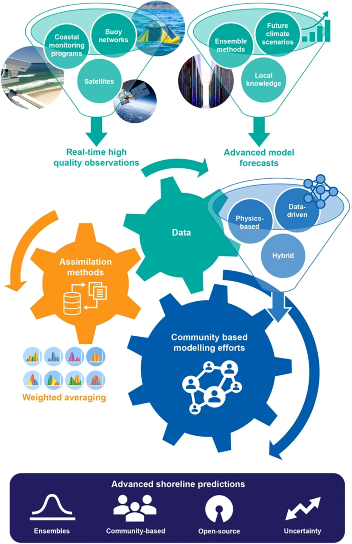
Figure 1 A framework for future shoreline change modeling (Splinter and Coco, 2021).
Conclusions
The main aims of this Research Topic were to analyze coastal erosion risk. However, the great variety of factors that influence coastal erosion risk make it a multidisciplinary Topic, as highlighted by the published papers. The most debated topics were shoreline changes, the vulnerability of coastal areas and the related methods of analysis, and the effects of sea storms and extreme events such as typhoons. Most of the papers used remote sensing, testifying the growing importance in the analysis and understanding phases of various phenomena, including coastal ones. Therefore, this Research Topic has significantly contributed to scientific advances in the complex field of coastal risk.
Author contributions
GB developed the idea for this Research Topic, and he was editor of a paper. GF and FD’A were co-Topic Editors and were editors of five and four papers, respectively. All three authors co-wrote this Editorial and approve the submitted version.
Conflict of interest
The authors declare that the research was conducted in the absence of any commercial or financial relationships that could be construed as a potential conflict of interest.
Publisher’s note
All claims expressed in this article are solely those of the authors and do not necessarily represent those of their affiliated organizations, or those of the publisher, the editors and the reviewers. Any product that may be evaluated in this article, or claim that may be made by its manufacturer, is not guaranteed or endorsed by the publisher.
References
Apostolopoulos D., Nikolakopoulos K. (2021). A review and meta-analysis of remote sensing data, GIS methods, materials and indices used for monitoring the coastline evolution over the last twenty years. Eur. J. Remote Sens. 54 (1), 240–265. doi: 10.1080/22797254.2021.1904293
Besset M., Anthony E. J., Bouchette F. (2019). Multi-decadal variations in delta shorelines and their relationship to river sediment supply: An assessment and review. Earth-Sci. Rev. 193, 199–219. doi: 10.1016/j.earscirev.2019.04.018
Boak E. H., Turner I. L. (2005). Shoreline definition and detection: a review. J. Coast. Res. 21 (4), 688–703. doi: 10.2112/03-0071.1
Bombino G., Barbaro G., D’Agostino D., Denisi P., Foti G., Labate A., et al. (2022). Shoreline change and coastal erosion: The role of check dams. first indications from a case study in calabria, southern Italy. Catena 217, 1–13. doi: 10.1016/j.catena.2022.106494
Boumboulis V., Apostolopoulos D., Depountis N., Nikolakopoulos K. (2021). The importance of geotechnical evaluation and shoreline evolution in coastal vulnerability index calculations. J. Mar. Sci. Eng. 9 (4), 423. doi: 10.3390/jmse9040423
Fiori E., Comellas A., Molini L., Rebora N., Siccardi F., Gochis D. J., et al. (2014). Analysis and hindcast simulations of an extreme rainfall event in the Mediterranean area: The Genoa 2011 case. Atmos. Res. 138, 13–29. doi: 10.1016/j.atmosres.2013.10.007
Luijendijk A., Hagenaars G., Ranasinghe R., Baart F., Donchyts G., Aarninkhof S. (2018). The state of the world’s beaches. Sci. Rep. 8, 1–11. doi: 10.1038/s41598-018-24630-6
Mavromatidi A., Briche E., Claeys C. (2018). Mapping and analyzing socio-environmental vulnerability to coastal hazards induced by climate change: an application to coastal Mediterranean cities in France. Cities 72, pp. doi: 10.1016/j.cities.2017.08.007
Mentaschi L., Vousdoukas M. I., Pekel J. F., Voukouvalas E., Feyen L. (2018). Global long-term observations of coastal erosion and accretion. Sci. Rep. 8 (1), 12876. doi: 10.1038/s41598-018-30904-w
Narra P., Coelho C., Sancho F., Palalane J. (2017). CERA: an open-source tool for coastal erosion risk assessment. Ocean Coast. Manage. 142, pp. doi: 10.1016/j.ocecoaman.2017.03.013
Ozpolat E., Demir T. (2019). The spatiotemporal shoreline dynamics of a delta under natural and anthropogenic conditions from 1950 to 2018: A dramatic case from the Eastern Mediterranean. Ocean Coast. Manage. 180, 104910. doi: 10.1016/j.ocecoaman.2019.104910
Pantusa D., D’Alessandro F., Riefolo L., Principato F., Tomasicchio G. (2018). Application of a coastal vulnerability index. a case study along the apulian coastline, Italy. Water 10 (9), 1–16. doi: 10.3390/w10091218
Viavattene C., Jiménez J. A., Ferreira O., Priest S., Owen D., McCall R. (2018). Selecting coastal hotspots to storm impacts at the regional scale: a coastal risk assessment framework. Coast. Eng. 134, 33–47. doi: 10.1016/j.coastaleng.2017.09.002
Keywords: coastal erosion, shoreline changes, sea storms, extreme events, anthropogenic pressure, vulnerable coastal regions, multicriteria decision analysis approach, remote sensing
Citation: Foti G, Barbaro G and D’Alessandro F (2022) Editorial: Innovations in coastal erosion risk assessment and mitigation. Front. Mar. Sci. 9:1066989. doi: 10.3389/fmars.2022.1066989
Received: 11 October 2022; Accepted: 13 October 2022;
Published: 20 October 2022.
Edited and Reviewed by:
Charitha Bandula Pattiaratchi, University of Western Australia, AustraliaCopyright © 2022 Foti, Barbaro and D’Alessandro. This is an open-access article distributed under the terms of the Creative Commons Attribution License (CC BY). The use, distribution or reproduction in other forums is permitted, provided the original author(s) and the copyright owner(s) are credited and that the original publication in this journal is cited, in accordance with accepted academic practice. No use, distribution or reproduction is permitted which does not comply with these terms.
*Correspondence: Giandomenico Foti, Z2lhbmRvbWVuaWNvLmZvdGlAdW5pcmMuaXQ=