- 1Faculty of Environment, Hanoi University of Natural Resources and Environment, Hanoi, Vietnam
- 2Pacific Southwest Research Station, United States Department of Agriculture (USDA) Forest Service, Institute of Pacific Islands Forestry, Hilo, HI, United States
- 3Vietnam Institute of Meteorology, Hydrology and Climate Change, Hanoi, Vietnam
- 4Faculty of Forestry, Nong Lam University, Ho Chi Minh, Vietnam
- 5Mangrove Ecosystem Research Center, Hanoi National University of Education, Hanoi, Vietnam
- 6Vietnam Institute of Geodesy and Cartography, Ministry of Natural Resources and Environment, Hanoi, Vietnam
- 7Department of Water-Environment-Oceanography, University of Science and Technology of Hanoi, Hanoi, Vietnam
Mangrove forest in the Mekong Delta plays important roles in protecting coasts from soil erosion and strong waves, supplying seafood, and accumulating carbon. Despite these benefits, mangroves have been and continue to be severely damaged by the impacts of natural and socioeconomic activities. In recent years, large areas of mangrove forest have been restored through planting and other various management actions. In this study, we analyzed high-resolution WorldView-2 images to quantify changes in the mangrove forest in seven coastal provinces (Tien Giang, Ben Tre, Tra Vinh, Soc Trang, Bac Lieu, Ca Mau, and Kien Giang) of the Mekong Delta from 2015 to 2020. Our study is one of the first to analyze mangrove forest change at the commune scale, the smallest official administrative unit in Vietnam, to determine the area of restored mangroves. The potentials and challenges in future mangrove restoration were also assessed by analyzing satellite imagery and field survey data. In the study area, mangrove forest area increased by 11,184 ha (approximately 2,237 ha per year) from 79,593 ha in 2015 to 90,777 ha in 2020. A total area of 16,138 ha (approximately 20.3%) was lost due to mangrove conversion to other land uses, aquaculture activities and coastal erosion, etc., while 27,322 ha (approximately 34.1%) was restored or newly planted during state- and NGO-funded mangrove restoration projects and programs. These results confirmed that mangrove restoration projects and programs have played a significant role in maintaining and increasing mangrove forest cover in Mekong Delta. The results can also assist managers and decision makers in mangrove restoration evaluation, and suggest analyzing WorldView-2 images to monitor mangrove restoration over time in Vietnam.
Introduction
Vietnam used to be known as one of the countries with a large area of mangroves in the world. In 1943, 408,500 ha of mangroves were distributed along its coastline, from Quang Ninh province in the north to Kien Giang province in the south (Hong and San, 1993; Tinh et al., 2022). These mangrove forests providing valuable ecosystem services to human populations that include: 1) coastal protection from storms, floods, and erosion, 2) carbon sequestration for climate change adaptation and mitigation, 3) the provision of fuel and raw material products, 4) habitat for aquatic and terrestrial species, and 5) and other social, human, financial and physical capital for local livelihoods (Hawkins et al., 2010; Pham et al., 2022). However, Vietnam mangrove forests were severely damaged by the Second Indochina War from 1955-1975 (Hong and San, 1993), the shrimp aquaculture boom of the 1980s and 1990s (de Graaf and Xuan, 1998), and impacts from climate change (e.g., sea level rise, increased storms) in recent decades (Ward et al., 2016; Truong et al., 2017).
The Mekong Delta possesses around 84% of Vietnam’s mangroves (Tinh et al., 2022). According to the Circular No. 34/2009/TT-BNNPTNT of the Ministry of Agriculture and Rural Development (MARD), Mekong Delta’s mangroves were classified into protection forest (protect soil and water resources, prevent erosion and desertification, limit disasters, regulate climate and protect the environment), special-use forest (natural preservation of national ecological standard samples and forest biological gene sources; scientific research; protection of historical and cultural relics and places of scenic beauty) and production forest (production and trading of timber, non-timber forest products). Due to the natural impacts and socioeconomic activities described above, mangrove area in Mekong region has significantly declined (de Graaf and Xuan, 1998; Hong et al., 2019; Liu et al., 2020). Phan and Stive (2022) reported that the total area of mangroves in Mekong Delta decreased from 185,800 ha in 1973 to 102,160 ha in 2020, with a loss of 2,150 ha per year to aquaculture expansion and 430 ha per year to coastal erosion. As a result, various policies and projects on mangrove restoration, rehabilitation, and plantations have been implemented in the Mekong Delta, including a state project on the protection and development of coastal forests during 2015-2020 and other mangrove projects funded by the World Bank, Oxfam, etc. (Pham et al., 2022).
Previous studies revealed that the condition and area of mangrove forest in the Mekong Delta was deteriorating and shrinking, respectively (Tong et al., 2004; Binh et al., 2005; Thu and Populus, 2007; Quyen, 2011; Bullock et al., 2017; Truong and Do, 2018; Hong et al., 2019; Liu et al., 2020; Phan and Stive, 2022; Pham et al., 2022). Tinh et al. (2022), however, reported a net gain in mangrove forest area through restoration/reforestation efforts by the Vietnamese government as well as other national and international organizations. Most of these remote sensing studies used Landsat images with a resolution 30 m (Bullock et al., 2017; Hong et al., 2019; Liu et al., 2020; Phan and Stive, 2022; Tinh et al., 2022) or Sentinel images with a resolution of 10 m (Pham et al., 2022). Only a few of these studies used higher resolution images (SPOT) and these studies only focused on one or two provinces (Tong et al., 2004; Thu and Populus, 2007). Because mangroves in Mekong Delta often grow along narrow areas of coastline or are fragmented into small patches, detailed mangrove ecosystem characterization becomes difficult with moderate-resolution satellite data (Green et al., 1998). Therefore, this study used high-resolution (1.84 m) WorldView-2 imagery to quantify changes in the mangrove forest along the Mekong Delta coast from 2015 to 2020. We analyzed the mangrove forest change at commune scale to determine the areas where mangroves were restored or lost. The challenges in mangrove restoration was also discussed. The results from this study will help Vietnam and the coastal provinces of the Mekong Delta assess mangrove restoration efforts during the past period 2015-2020 as well as the next periods from 2021-2025 and 2021-2030. This latter period is particularly important as a project on the protection and development of coastal forests from 2021- 2030 was recently approved by the Vietnam Government on 10 October 2021 (MARD, 2021; Pham et al., 2022).
Materials and methods
Study area
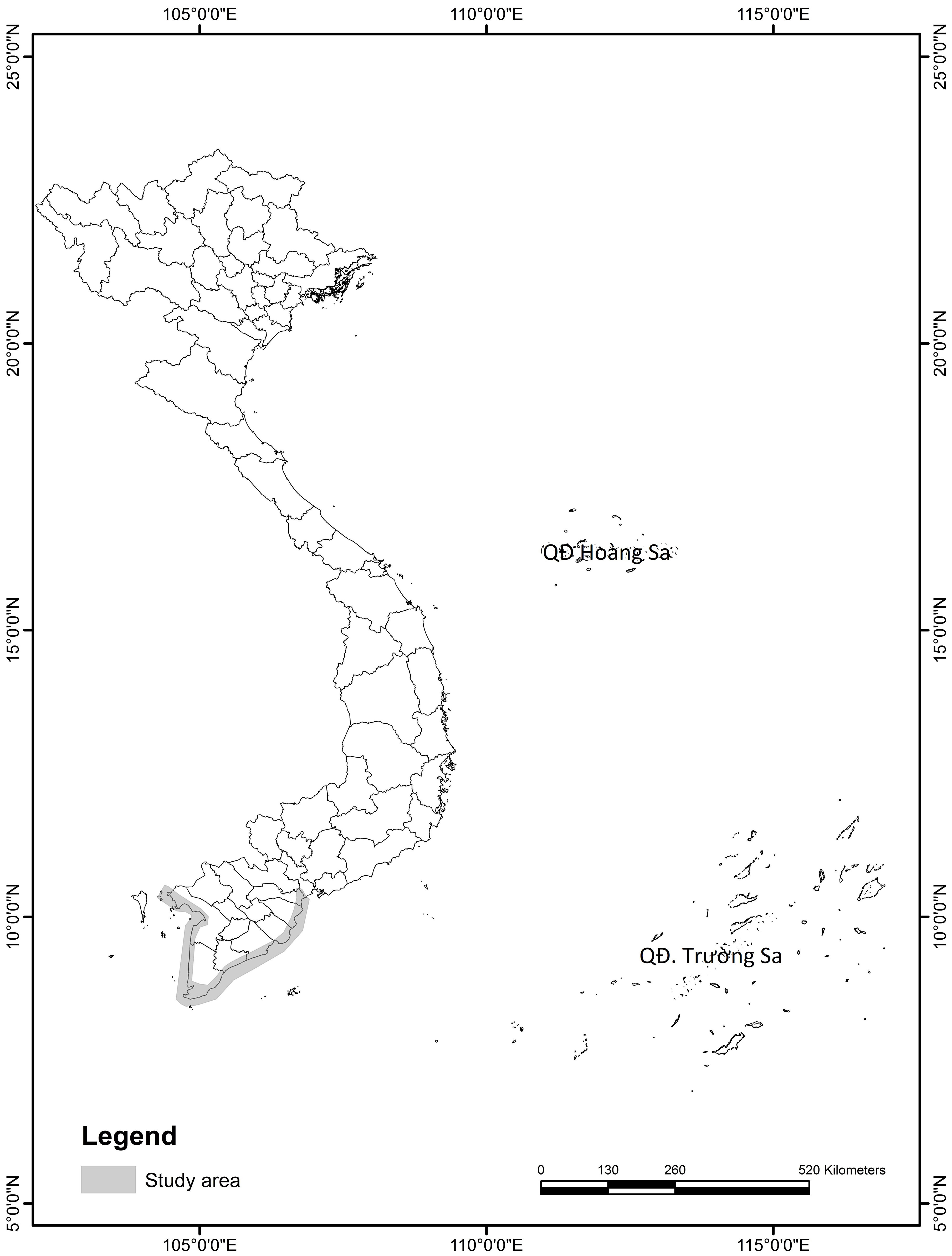
This study was carried out in seven provinces (Tien Giang, Ben Tre, Tra Vinh, Soc Trang, Bac Lieu, Ca Mau, Kien Giang) across the coastal area of the Mekong Delta, including 99 coastal communes within 26 different districts (Figure 1). This tropical region is characterized by a short dry season from January to March and a more extended rainy season from April to December (Tong et al., 2004), an average temperature of 25-27°C, and an annual precipitation of 1,600-2,000 mm (Nguyen and Nguyen, 2013). The Mekong Delta has a low-lying topography, receives abundant nutrient-rich alluvial deposits from the Mekong and Dong Nai rivers (Veettil et al., 2019), and contains the largest area of Vietnam’s mangrove forest with a total of 69 mangrove species (Hong and San, 1993). The mangrove forests in the Mekong Delta are typically dominated by Rhizophora apiculata, R. mucronata, Avicennia alba, A. officinalis, Sonneratia alba, Bruguiera cylindrixa, B. parviflora (Tri, 1999). Numerous mangrove restoration efforts were carried out between 2015 and 2020 in response to the large areas of mangroves that have been deforested and degraded from mangrove conversion to other land uses and the effects of climate change (Pham et al., 2022).
Satellite data
In this study, both WorldView-2 and Sentinel-2 (Sentinel-2A and 2B) images were used. WorldView-2 is a high-resolution satellite that was launched on October 8, 2009 to collect panchromatic imagery of 0.46 m resolution, and eight-band multispectral imagery with 1.84 m resolution. These represent some of the highest resolution satellite images available. A total of 118 WV-2 images covering the study area (56 images for 2015 and 82 images for 2020) were obtained from the Polar Geospatial Center (University of Minnesota) to track changes in mangrove extent. The average cloud cover of the WV-2 images over the study area for 2015 and 2020 were 16.38% and 23.94%, respectively. Sentinal-2A was launched on June 23, 2015 and Sentinel-2B was launched on March 7, 2017 to acquire optical imagery with 13 bands that consist of 4 bands with 10 meters spatial resolution, 6 bands with 20 meters, and 3 bands with 60 meters. In this study, eight Sentinel-2 images with an average cloud cover over of less than 5% were downloaded from the Copernicus Open Access Hub (https://scihub.copernicus.eu/dhus/#/home), georeferenced to 1.84 m resolution to ensure proper alignment, and compensated for frequent cloud cover of WV-2 images (Alm et al., 2020). The Sentinel-2 images were georeferenced to 1.84 m WV-2 imagery to ensure proper alignment. As both WV-2 and Sentinel-2 images used in this study were single-date imagery, we only selected images taken near or at low tide to minimize the amount of mangrove area that was submerged by the tide.
Ground truth data
Ground truth data was collected from June 05 to 19, 2022, to describe land cover at 250 randomly selected reference points that contained either mangrove forest (150 points) or other land cover (100 points) for proper imagery classification. A Garmin GPSMAP64 with approximately 3 m accuracy was used to take GPS waypoints at each visited ground reference point. Photographs were also taken at each point to ensure that the area at each point was correctly described. Ground reference points were later used to calibrate and assess the accuracy of the land use classification. In order to better understand the current management status and use of mangrove forest, we also conducted semi-structured interviews in six communes (Binh An, Thuan Hoa, Van Khanh Dong, Vien An, Dat Moi and Tan An) with the highest percentage of mangrove loss. A total of 100 people (12 forest rangers, 8 local guards, 10 local authorities from the Commune People’s Committee, and 70 local villagers living nearby and under mangrove canopy) were interviewed during the ground truth survey. The semi-structured interview (Supplementary Table S1) contained a series of questions that provided us with qualitative data on past and present mangrove management and restoration, natural and social-economic activities affecting mangrove, and historical mangrove distribution change. This interview-based data was used in combination with remote sensing-based estimate and published information to discuss the successes and challenges of mangrove restoration in the Mekong Delta.
Satellite imagery processing
The WV-2 images for 2015 and 2020 were pre-processed using the FLAASH (Fast Line-of-sight Atmospheric Analysis of Spectral Hypercubes) algorithm in ENVI 5.3 to correct the atmosphere. As cloud cover is recognized as a significant loss of data and information quality, the cloud portions of WV-2 images were detected and removed using the Con tool in ArcGIS Desktop. These gaps were then filled with the cloud free Sentinel-2 images taken during the same year (Das et al., 2020). These compensated images were then clipped to extract the areas of interest where mangroves were more likely to be present (e.g., low-lying areas, intertidal zones and estuaries) for further analysis. Images were then segmented into homogeneous objects using eCognition software application and classified into two classes: mangroves and non-mangroves using the supervised image classification technique of Maximum Likelihood Classification (Islam et al., 2019; Thakur et al., 2021). Non-mangrove land class included agricultural, commercial and industrial area, residential area, roads, exposed soils, bare land and open water. In the image classification, 500 training samples (250 for each class) were randomly selected using Google Earth and existing land use maps.
The validation data collected from ground truthing land cover maps and Google Earth for the year 2020 and from land cover maps and Google Earth for the year 2015 was used to assess land cover classification accuracy. The validation points of each land cover class were converted to raster. Validation raster was then snapped to each land cover layer and compared to calculate metrics of accuracy that include producer’s accuracy, user’s accuracy, overall accuracy, and overall kappa statistic (Landis and Koch, 1977; Fisher et al., 2018).
Results
Mangrove classification and spatial distribution showed that from 2015 to 2020, Mekong Delta mangroves were distributed along the study area, with the greatest concentration of area in Ca Mau province and narrow coastal strips in other provinces (Figure 2). The overall accuracy of the classified maps for 2015 and 2020 were 90.33% and 93.00%, respectively, and the kappa coefficient were 0.81 and 0.86, respectively (Table 1). These accuracy metrics showed an acceptable agreement between the classification results and reference data (Dan et al., 2016; Thomas et al., 2018; Nguyen et al., 2020b).
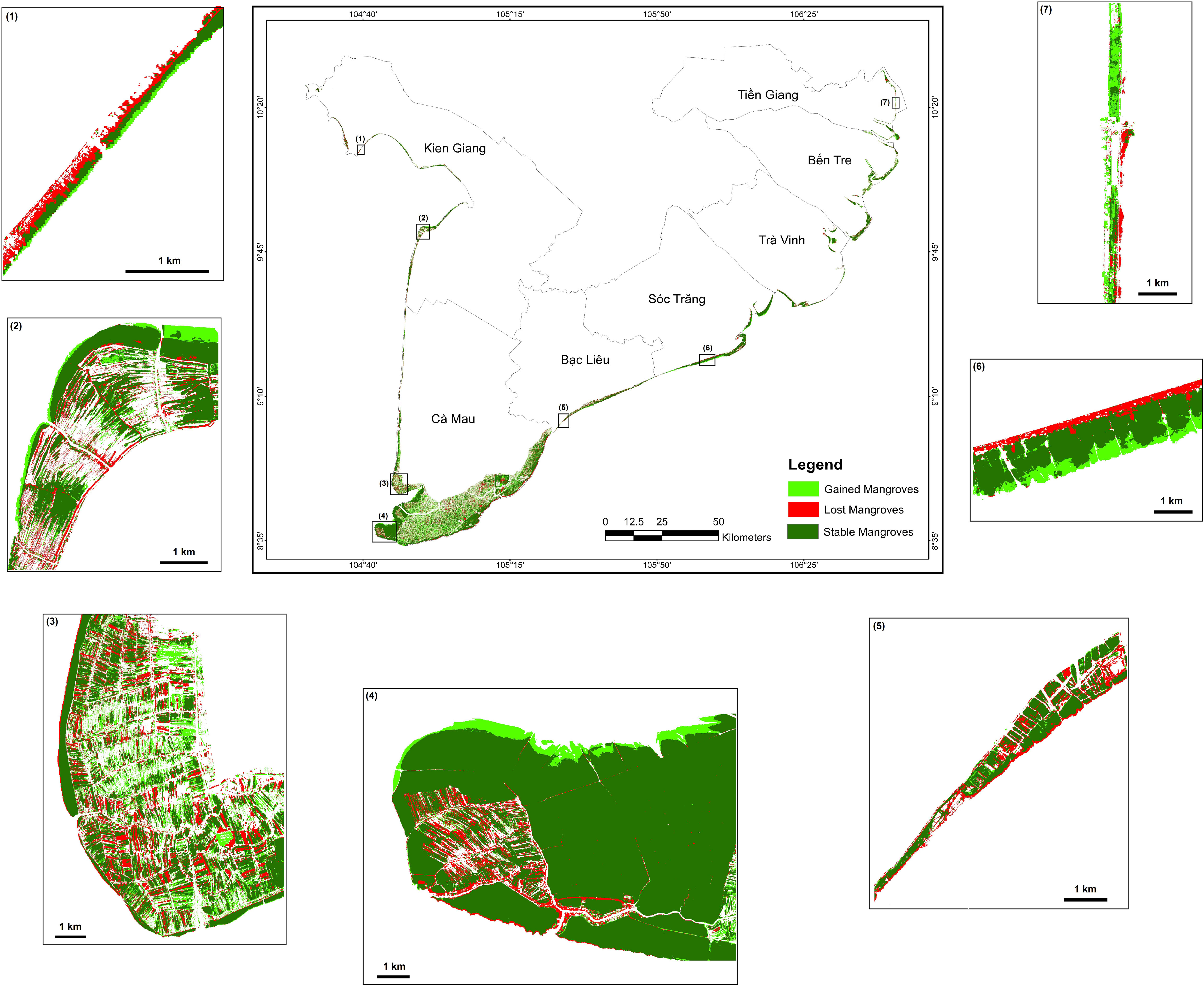
Figure 2 Spatial distribution of existing (stable) mangroves and mangrove change in the Mekong Delta from 2015-2020.
Due to the influence of aquaculture under the forest canopy over the past several decades and the dramatically growing erosion of the shoreline in recent years, mangrove forests in the western coastal area were much more fragmented than along the eastern coast. Mangroves were more unified and well-developed on the eastern and southern coastal area. In Ca Mau Cape where mangroves were well-managed by national parks and protection forest management boards, mangrove forests were dense and homogeneous. A large area of mangrove forest designated as production forest, was found lying further inland, which was given to the local villagers for reforestation and alternate harvesting once the trees reached the proper size.
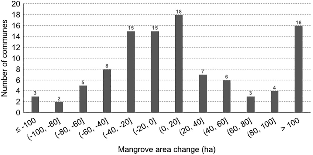
In the study area, mangrove forest covered 79,593 ha in 2015 and increased to 90,777 ha in 2020. The loss of mangroves from 2015 to 2020 was 16,138 ha (approximately 20.3%), while 27,322 ha (approximately 34.1%) was restored or newly planted. As a consequence, the Mekong Delta’s overall net area of mangrove forest increased by 11,184 ha (approximately 2,237 ha per year). Classification findings indicated that almost 80% of mangrove area remained unchanged. A more detailed analysis at the commune level revealed variations in the rate of mangrove change. Out of the 102 communes in the study area, mangrove area increased in 54 communes but decreased in the remaining 48 communes (Figure 3). The communes with mangrove area loss were mainly in the western Kien Giang province and in the eastern Tra Vinh and Bac Lieu provinces while the provinces of Ca Mau, Ben Tre, and Soc Trang had the majority of communes that experienced increasing mangrove areas. The communes with the most significant increase in mangrove area were Vien An Dong (2,810 ha), Lam Hai (1,860 ha), Vien An (1,894 ha), Rach Goc (1,020 ha), Tan An Tay (993 ha), and Dat Mui (748 ha). In contrast, Vinh Hai (-185 ha), Binh An (-160 ha), Vinh Thinh (-145 ha), Tan Thuan (-86 ha), and Thuan Hoa (-83 ha) communes lost the largest areas of mangroves (Figure 3; Supplementary Table S2). Supplementary Table S2 also provides more detailed information on the area of mangroves gained and lost for the entire study area.
Discussion
Achievements in mangrove restoration
Both natural and anthropogenic factors have caused major losses in Vietnam’s mangrove area and distribution (Hawkins et al., 2010; Dat and Yoshino, 2011; Pham and Yoshino, 2016; Hauser et al., 2017; Nguyen et al., 2019). In this study, analyses of WorldView-2 data for the period of 2015 to 2020 revealed that mangrove area has increased by 11,184 ha in seven provinces of the Mekong Delta (approximately 2.8% increase by area per year) (Supplementary Table S2). The rate of mangrove increase in this study area is higher than the estimate of 0.4% by area per year for nine southern provinces (include Ho Chi Minh city, Ba Ria - Vung Tau and 07 provinces of the Mekong Delta) (Hawkins et al., 2010; Pham et al., 2022), lower than in other parts of the country like Thanh Hoa in the north where mangroves increased up to 16% by area per year (Nguyen et al., 2020a) and much better than many other parts of the world where mangrove loss is still occurring (Toosi et al., 2019; Halder et al., 2021; Kiprono, 2021). Beside the differences in time periods and the extent of study areas, the resolution of the satellite images used also caused the differences in estimates of mangrove change. Vietnam’s mangrove forests are mostly distributed in elongated or fragmented patches which are often narrower or smaller than the pixel size of medium-resolution imagery with 10-100 m resolution. Xia et al. (2018) discussed mapping mangrove forests with high-resolution imagery with several meters resolution can produce results with the highest accuracy to date.
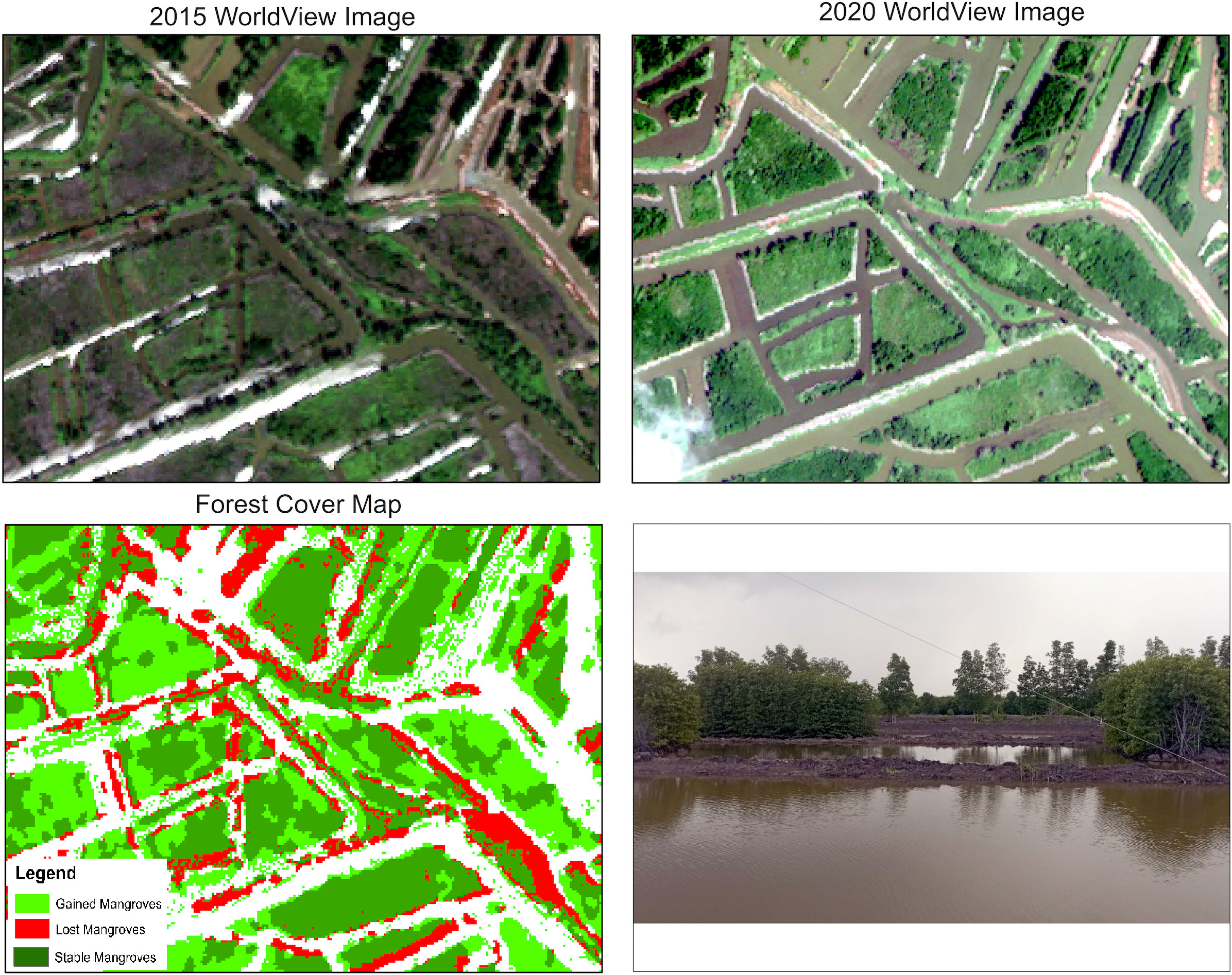
The mangrove area increase is likely due to the long history of successful mangrove restoration efforts that have occurred in Vietnam (Hai et al., 2020). Vietnam has a strong legal framework that emphasizes the need to enhance mangrove restoration and the financial commitments from government to fund these efforts. Each province in the study area has also issued policies on mangrove management and restoration (Pham et al., 2022). This has resulted in many restoration programs and projects that have been implemented since the early 1990s (Hai et al., 2020). Furthermore, national projects like the National Target Program to Respond to Climate Change and Green Growth from 2016-2020 (Decision No.1670/QD-TTg dated 31 October 2017) and other related programs resulted in 39 projects that were implemented to protect and develop coastal forests in seven coastal provinces of the study area (Table 2). In addition to these state-funded projects, mangrove restoration in Mekong Delta has also received support from international NGOs that include KFW Development Bank (MARD, 2014), Green Climate Fund (SNV, 2016), The United Nations Development Program (UNDP, 2015), International Climate Initiative (MARD, 2014) and World Bank (WB, 2017). These projects and initiatives all contributed to successful mangrove restoration projects and programs that have played a significant role in maintaining and increasing mangrove forest cover in Mekong Delta (Figure 4).
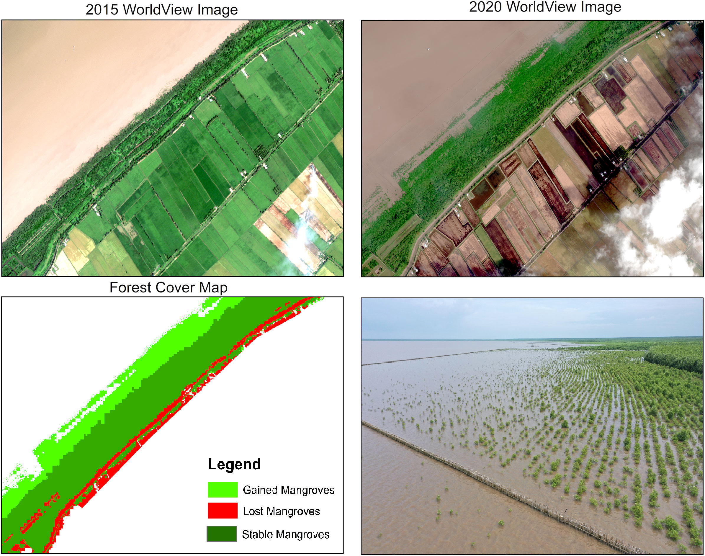
Figure 4 Mangroves are successfully restored to the sea and attributed to high sediment deposition and land creation that occurs along these shorelines.
Mangroves are one of the most carbon-rich ecosystems in tropical regions (Alongi, 2012; Donato et al., 2012). In the Mekong Delta, Nam et al. (2016) reported that carbon stocks from natural mangroves and 35 year old restored mangroves were not different. This suggests that restoration can quickly return C to degraded/deforested mangroves and that mangrove restoration plays a significant role in carbon emission reduction strategies and should be integrated into related international agreements. In Vietnam’s Intended Nationally Determined Contributions, mangrove plantations were proposed as one of the important options for climate change mitigation (Hai et al., 2020) and could help Vietnam will reach its net-zero carbon emission target by 2050. Vietnam has also committed to reducing greenhouse gas emissions by 9% with domestic resources and 27% with international support by 2030. Moreover, with the adoption of the Paris Agreement, 29 Parties that include Vietnam have committed to using mangrove restoration as a climate mitigation activity (Hai et al., 2020). These could be important basis for the boom of mangrove restoration projects in the coming years, especially when restoration projects are well designed. For the 2021-2025 period, the Mekong Delta provinces have designated large areas (approximately 91,000 ha) for mangrove restoration and afforestation. These areas have been allocated for forestry purposes but are either currently without forest cover or have newly planted forests with low survival rates that could be enriched with additional planting (MARD, 2021; Pham et al., 2022).
Challenges in mangrove restoration
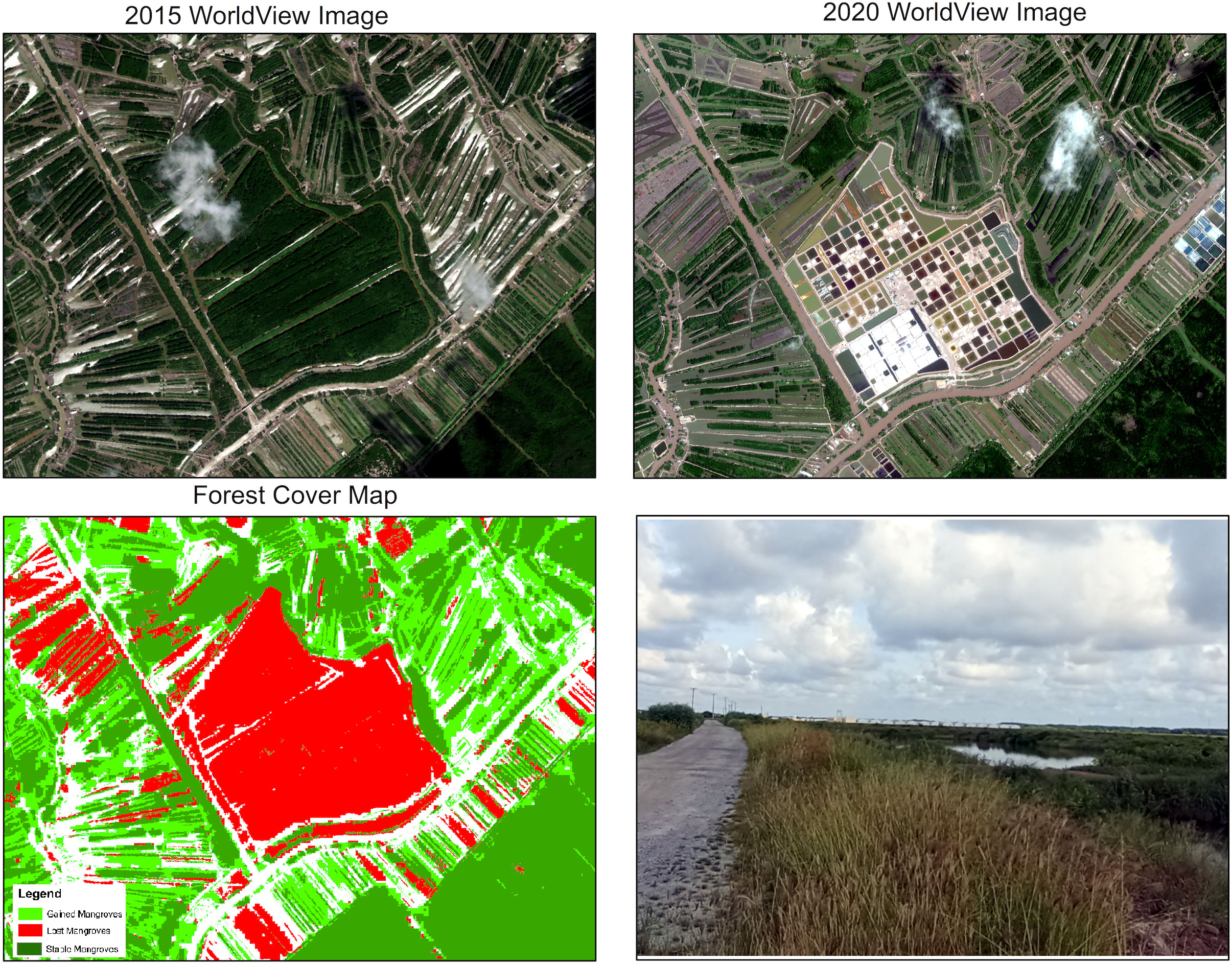
While mangrove area has increased in the entire study area, 48 of 99 study communes have experienced mangrove loss. Increases in mangrove forest area are concentrated in only a few communes (Figure 2; Supplementary Table S2) and mostly in production forest areas where trees will be harvested as soon as they reach a proper size. This means mangroves still remain at high risk of deforestation. Furthermore, while a large area has been designated for mangrove restoration, those restoration projects continue to face many challenges from both natural and anthropogenic impacts. First, mangrove forests are usually distributed in narrow strips along the coast that are vulnerable to coastal squeeze that results from erosion at the oceanic mangrove interface and development at the mangrove upland interface that limits the ability of mangrove to migrate inland (Phan et al., 2015; Truong et al., 2017). Coastline erosion and the construction of sea dikes to create more inland space for fish/shrimp farming and cultivation as well as to prevent salinity intrusion were both observed at many of our sampled sites (Figure 5). Second, the conversion of mangroves to other land uses that are still active and that include agriculture, aquaculture and other socioeconomic activities (Figure 6) in areas planned for mangrove restoration limits the success and effectiveness as well as justification for restoring those areas (Pham et al., 2022). Third, management related issues are also likely to have a decisive impact on mangrove restoration in Mekong Delta (Hai et al., 2020). Co-management was an effective way of maintaining and enhancing the protection function of the mangrove forest while at the same time providing livelihood for local communities. The integrated mangrove aquaculture systems such as mud crab fattening in mangrove pens and cages, mixed shrimp-mangrove-crab-cockle systems or integrated mangrove fish or shrimp farms were considered an effective solution to improve local livelihoods (Macintosh and Ashton, 2003). However, such systems also generated a potential challenge for mangrove restoration and management as the farmers illegally cut down mangroves or gradually cut down the roots of mangroves to weaken or kill trees in order to increase their aquaculture production (Figure 7). To solve this issue, a pilot project managed by the Forest Ranger of Bien Tay Protection Forest in 2015 was carried out to resettle the villagers, who implemented integrated mangrove aquaculture systems in Khanh Hoi, Khanh Binh Tay, Khanh Hai and Song Doc communes to inland areas and mangroves will be restored within their ponds. However, until now, hundreds of households have yet to move to a new place due to the lack of a new livelihood to support them.
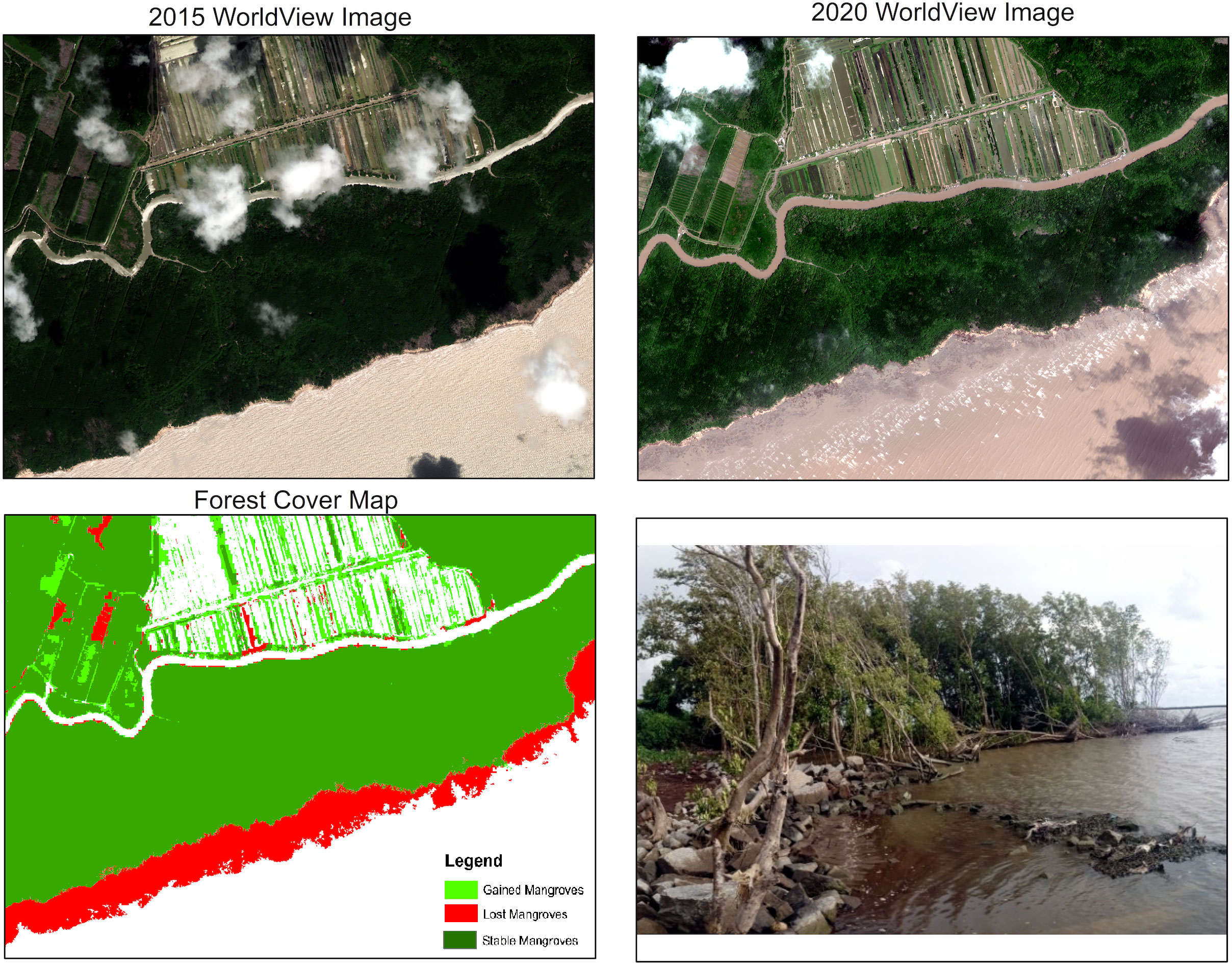
Figure 5 Mangrove squeeze that results from coastal erosion and inland barriers that prevent mangrove migration.
The results of this study showed that the mangrove area of Mekong Delta increased by 11,184 ha during the 2015-2020 period (approximately 2,237 ha per year). The mangrove area increased in 54 communes that were mainly in eastern and southern provinces (e.g. Ca Mau, Ben Tre, and Soc Trang), but declined in the remaining 48 communes that were mainly in the western Kien Giang province. The state-funded mangrove restoration projects under the National Target Program to Respond to Climate Change and Green Growth for 2016-2020 and related programs, and other mangrove restoration projects supported from the international NGOs have played a significant role in maintaining and increasing mangrove forest cover in Mekong Delta. For the 2021-2025 and 2026-2030 periods, a large area has been designated for mangrove restoration under the National Program on Protection and Development of Forests in Coastal Areas to Respond to Climate Change and Promote Green Growth for 2021-2030. These mangrove restoration projects, however, will face challenges from both natural and anthropogenic impacts (e.g. coastal erosion, mangrove conversion and aquaculture activities). The results from this study could help Vietnam assess successful and failed mangrove restoration results from 2015-2020 in order to identify factors that will increase future restoration project that will occur from 2021-2025 and 2026-2030, when new state programs on the protection and development of coastal forests will be implemented. Results could also be used to identify degraded mangrove areas that could be prioritized for restoration as it is within these areas where restoration is often the most likely to succeed (Lewis and Brown, 2014). It should be noted, however, that in this study we selected images taken near or at low tide to minimize the amount of mangrove area that was submerged by the tide, but that could not completely eliminate errors in mangrove classification in the intertidal mudflats where submerged mangrove forests locally occur even at low tide. More advanced techniques should be utilized to solve this issue in further studies.
Data availability statement
The original contributions presented in the study are included in the article/Supplementary Material. Further inquiries can be directed to the corresponding author.
Author contributions
PT and RM conceived the study, and wrote and edited the manuscript draft. PT, TH, HH and ML collected and analyzed satellite images, and performed data analysis. PT, TH, TV, PH, HH and ML collected field data. NH and BH assisted in gathering literature and writing the manuscripts draft. All authors contributed to the article and approved the submitted version.
Funding
This study was conducted with financial support from the US Forest Service International Programs (USFS/IP) under the project number IPC0.017.0911.001.
Acknowledgments
We want to thank the Polar Geospatial Center, University of Minnesota that kindly provided the WorldView-2 images. We also want to thank the local authorities for their supports in our field survey. Without their help and efforts, this work would not be possible.
Conflict of interest
The authors declare that the research was conducted in the absence of any commercial or financial relationships that could be construed as a potential conflict of interest.
Publisher’s note
All claims expressed in this article are solely those of the authors and do not necessarily represent those of their affiliated organizations, or those of the publisher, the editors and the reviewers. Any product that may be evaluated in this article, or claim that may be made by its manufacturer, is not guaranteed or endorsed by the publisher.
Supplementary material
The Supplementary Material for this article can be found online at: https://www.frontiersin.org/articles/10.3389/fmars.2022.1043943/full#supplementary-material
References
Alm J., Masjkur M., Arifatmi B., Arquero A., Artz R., Ballhorn U., et al. (2020). Peatlands mapping and monitoring: Recommendations and technical overview (Rome: Food and Agriculture Organization of the United Nations (FAO).
Alongi D. M. (2012). Carbon sequestration in mangrove forests. Carbon Manage. 3, 313–322. doi: 10.4155/cmt.12.20
Binh T. N. K. D., Vromant N., Hung N. T., Hens L., Boon E. K. (2005). Land cover changes between 1968 and 2003 in cai nuoc, Ca mau peninsula, Vietnam. Environ. Dev. Sustain. 7, 519–536. doi: 10.1007/s10668-004-6001-z
Bullock E. L., Fagherazzi S., Nardin W., Vo-Luong P., Nguyen P., Woodcock C. E. (2017). Temporal patterns in species zonation in a mangrove forest in the Mekong delta, Vietnam, using a time series of landsat imagery. Continent. Shelf Res. 147, 144–154. doi: 10.1016/j.csr.2017.07.007
Dan T. T., Chen C. F., Chiang S. H., Ogawa S. (2016). Mapping and change analysis in mangrove forest. ISPRS Ann. Photogramm. Remote Sens. Spatial Inf. Sci. III-8, 109–116. doi: 10.5194/isprs-annals-III-8-109-2016
Das S., Das P., Roy B. R. (2020). "Cloud detection and cloud removal of satellite image–A case study". In: Sarma H., Bhuyan B., Borah S., Dutta N. eds. Trends in Communication, Cloud, and Big Data. Lecture Notes in Networks and Systems, vol. 99. (Singapore: Springer). doi: 10.1007/978-981-15-1624-5_6
Dat P. T., Yoshino K. (2011). “Monitoring mangrove forest using multi-temporal satellite data in the northern coast of Vietnam,” In: Proceeding of the 32th Asian Conference on Remote Sensing 2011, 3-7 Oct. Taipei, Taiwan. 1, 169–174.
de Graaf G. J., Xuan T. T. (1998). Extensive shrimp farming, mangrove clearance and marine fisheries in the southern provinces of Vietnam. Mangroves Salt Marshes 2, 159–166. doi: 10.1023/A:1009975210487
Donato D. C., Kauffman J. B., Mackenzie R. A., Ainsworth A., Pfleeger A. Z. (2012). Whole-island carbon stocks in the tropical pacific: Implications for mangrove conservation and upland restoration. J. Environ. Manage. 97, 89–96. doi: 10.1016/j.jenvman.2011.12.004
Fisher J. R. B., Acosta E. A., Dennedy-Frank P. J., Kroeger T., Boucher T. M. (2018). Impact of satellite imagery spatial resolution on land use classification accuracy and modeled water quality. Remote Sens. Ecol. Conserv. 4, 137–149. doi: 10.1002/rse2.61
Green E. P., Clark C. D., Mumby P. J., Edwards A. J., Ellis A. C. (1998). Remote sensing techniques for mangrove mapping. International Journal of Remote Sensing 19 (5), 935–56. doi: 10.1080/014311698215801
Hai N. T., Dell B., Phuong V. T., Harper R. J. (2020). Towards a more robust approach for the restoration of mangroves in Vietnam. Ann. For. Sci. 77, 18. doi: 10.1007/s13595-020-0921-0
Halder S., Samanta K., Das S., Pathak D. (2021). Monitoring the inter-decade spatial–temporal dynamics of the sundarban mangrove forest of India from 1990 to 2019. Reg. Stud. Mar. Sci. 44, 101718. doi: 10.1016/j.rsma.2021.101718
Hauser L. T., Nguyen Vu G., Nguyen B. A., Dade E., Nguyen H. M., Nguyen T. T. Q., et al. (2017). Uncovering the spatio-temporal dynamics of land cover change and fragmentation of mangroves in the Ca mau peninsula, Vietnam using multi-temporal SPOT satellite imagery, (2004–2013). Appl. Geogr. 86, 197–207. doi: 10.1016/j.apgeog.2017.06.019
Hawkins S., To P. X., Phuong P. X., Thuy P. T., Tu N. D., Guong C. V., et al. (2010). Roots in the water: Legal frameworks for mangrove PES in Vietnam (Washington, DC, USA: Forest Trends).
Hong H. T. C., Avtar R., Fujii M. (2019). Monitoring changes in land use and distribution of mangroves in the southeastern part of the Mekong river delta, Vietnam. Trop. Ecol. 60, 552–565. doi: 10.1007/s42965-020-00053-1
Hong P. N., San H. T. (1993). Mangroves of Vietnam (Bangkok, Thailand: The IUCN Wetlands Programme).
Islam M. M., Borgqvist H., Kumar L. (2019). Monitoring mangrove forest landcover changes in the coastline of Bangladesh from 1976 to 2015. Geocarto Int. 34, 1458–1476. doi: 10.1080/10106049.2018.1489423
Kiprono A. (2021). An assessment of the effectiveness of mangrove restoration projects along the Kenyan coast (Nairobi, Kenya: University of Nairobi).
Landis J. R., Koch G. G. (1977). The measurement of observer agreement for categorical data. Biometrics 33, 159–174. doi: 10.2307/2529310
Lewis R. R., Brown B. (2014). “Ecological mangrove rehabilitation – a field manual for practitioners,” in Mangrove action project (Canadian International Development Agency and OXFAM).
Liu S., Li X., Chen D., Duan Y., Ji H., Zhang L., et al. (2020). Understanding land use/Land cover dynamics and impacts of human activities in the Mekong delta over the last 40 years. Global Ecol. Conserv. 22, e00991. doi: 10.1016/j.gecco.2020.e00991
Macintosh D. J., Ashton E. C. (2003). Draft code of conduct for the sustainable management of mangrove ecosystems (Washington: World Bank, ISME, cenTER Aarhus).
MARD (2014). Coastal forest protection and development plan to respond to climate change for the period 2015–2020. (Hanoi, Vietnam: Vietnamese Ministry of Agriculture and Rural Development).
MARD (2021). National program on protection and development of forests in coastal target to climate change and promote green growth for 2021–2030. (Hanoi, Vietnam: Vietnamese Ministry of Agriculture and Rural Development)
Nam V. N., Sasmito S. D., Murdiyarso D., Purbopuspito J., MacKenzie R. A. (2016). Carbon stocks in artificially and naturally regenerated mangrove ecosystems in the Mekong delta. Wetlands Ecol. Manage. 24, 231–244. doi: 10.1007/s11273-015-9479-2
Nguyen H. Q., Brunner J. (2011). Land cover change assessment in the coastal areas of the Mekong delta 2004-2009 (Hanoi, Vietnam: IUCN).
Nguyen H.-H., Nghia N. H., Nguyen H. T. T., Le A. T., Ngoc Tran L. T., Duong L. V. K., et al. (2020a). Classification methods for mapping mangrove extents and drivers of change in thanh hoa province, Vietnam during 2005-2018. For. Soc. 4, 225–242. doi: 10.24259/fs.v4i1.9295
Nguyen H. Q., Le T. V. H., Quinn C., Carrie R., Pham T. T. N., Stringer L., et al. (2019). "Spatial planning influences mangrove forest development in Kim son district of Ninh Binh province". In: FIG Working Week 2019: Geospatial information for a smarter life and environmental resilience. (Hanoi, Vietnam).
Nguyen D. N., Nguyen T. H. (2013). Climate and climatic resources of Vietnam (Hanoi, Vietnam: Publishing House of Science and Technology).
Nguyen H.-H., Tran L. T. N., Le A. T., Nghia N. H., Duong L. V. K., Nguyen H. T. T., et al. (2020b). Monitoring changes in coastal mangrove extents using multi-temporal satellite data in selected communes, Hai Phong city, Vietnam. For. Soc. 4, 256–270. doi: 10.24259/fs.v4i1.8486
Pham T. T., Vien N. N., Vo Q. T., Tang T. K. H., Nguyen T. L., Tran N. M. H., et al. (2022). Opportunities and challenges for mangrove restoration in the Mekong delta: Status, policies and stakeholder (Bogor, Indonesia: CIFOR).
Pham T. D., Yoshino K. (2016). Impacts of mangrove management systems on mangrove changes in the northern coast of Vietnam. Tropics 24, 141–151. doi: 10.3759/tropics.24.141
Phan M. H., Stive M. J. F. (2022). Managing mangroves and coastal land cover in the Mekong delta. Ocean Coast. Manage. 219, 106013. doi: 10.1016/j.ocecoaman.2021.106013
Phan L. K., Jaap S. M., van Thiel de Vries Marcel, Marcel J.F.S. (2015). Coastal Mangrove Squeeze in the Mekong Delta. Journal of Coastal Research 31 (2), 233–243. doi: 10.2112/JCOASTRES-D-14-00049.1
SNV (2016). MAM 1: Promoting ecosystem-based adaptation through reforestation and sustainable use of mangroves (The Hague: Netherlands Development Organization).
Thakur S., Maity D., Mondal I., Basumatary G., Ghosh P. B., Das P., et al. (2021). Assessment of changes in land use, land cover, and land surface temperature in the mangrove forest of sundarbans, northeast coast of India. Environ. Dev. Sustain. 23, 1917–1943. doi: 10.1007/s10668-020-00656-7
Thomas N., Bunting P., Lucas R., Hardy A., Rosenqvist A., Fatoyinbo T. (2018). Mapping mangrove extent and change: A globally applicable approach. Remote Sensing 10. 1466.
Thu P. M., Populus J. (2007). Status and changes of mangrove forest in Mekong delta: Case study in tra vinh, Vietnam. Estuarine Coast. Shelf Sci. 71, 98–109. doi: 10.1016/j.ecss.2006.08.007
Tinh P. H., MacKenzie R. A., Hung T. D., Hanh N. T. H., Hanh N. H., Manh D. Q., et al. (2022). Distribution and drivers of Vietnam mangrove deforestation from 1995 to 2019. Mitigation Adapt. Strateg. Global Change 27, 29. doi: 10.1007/s11027-022-10005-w
Tong P., Auda Y., Populus J., Aizpuru M., Habshi A., Blasco F. (2004). Assessment from space of mangroves evolution in the Mekong delta, in relation to extensive shrimp farming. Int. J. Remote Sens. 25, 4795–4812. doi: 10.1080/01431160412331270858
Toosi N. B., Soffianian A. R., Fakheran S., Pourmanafi S., Ginzler C., Waser L. T. (2019). Comparing different classification algorithms for monitoring mangrove cover changes in southern Iran. Global Ecol. Conserv. 19, e00662. doi: 10.1016/j.gecco.2019.e00662
Truong T. D., Do L. H. (2018). Mangrove forests and aquaculture in the Mekong river delta. Land Use Policy 73, 20–28. doi: 10.1016/j.landusepol.2018.01.029
Truong S. H., Ye Q., Stive M. J. F. (2017). Estuarine mangrove squeeze in the Mekong delta, Vietnam. J. Coast. Res. 33, 747–763. doi: 10.2112/JCOASTRES-D-16-00087.1
UNDP (2015). Funding proposal: Improving the resilience of vulnerable coastal communities to climate change related impacts in Vietnam. (Hanoi, Vietnam).
Veettil B. K., Ward R. D., Quang N. X., Trang N. T. T., Giang T. H. (2019). Mangroves of Vietnam: Historical development, current state of research and future threats. Estuarine Coast. Shelf Sci. 218, 212. doi: 10.1016/j.ecss.2018.12.021
Ward R. D., Friess D. A., Day R. H., Mackenzie R. A. (2016). Impacts of climate change on mangrove ecosystems: A region by region overview. Ecosyst. Health Sustain. 2, e01211. doi: 10.1002/ehs2.1211
WB (2017). Vietnam - forest sector modernization and coastal resilience enhancement project (Washington: World Bank).
Keywords: mangroves, restoration, worldview, Mekong, Vietnam
Citation: Tinh PH, MacKenzie RA, Hung TD, Vinh TV, Ha HT, Lam MH, Hanh NTH, Tung NX, Hai PM and Huyen BT (2022) Mangrove restoration in Vietnamese Mekong Delta during 2015-2020: Achievements and challenges. Front. Mar. Sci. 9:1043943. doi: 10.3389/fmars.2022.1043943
Received: 14 September 2022; Accepted: 14 November 2022;
Published: 01 December 2022.
Edited by:
Lorenzo Mari, Politecnico di Milano, ItalyReviewed by:
Huong Nguyen, Murdoch University, AustraliaMichael Alister Reid, University of New England, Australia
Copyright © 2022 Tinh, MacKenzie, Hung, Vinh, Ha, Lam, Hanh, Tung, Hai and Huyen. This is an open-access article distributed under the terms of the Creative Commons Attribution License (CC BY). The use, distribution or reproduction in other forums is permitted, provided the original author(s) and the copyright owner(s) are credited and that the original publication in this journal is cited, in accordance with accepted academic practice. No use, distribution or reproduction is permitted which does not comply with these terms.
*Correspondence: Pham Hong Tinh, cGh0aW5oQGh1bnJlLmVkdS52bg==
 Pham Hong Tinh
 Richard A. MacKenzie
 Tran Dang Hung3
 Truong Van Vinh
 Bui Thanh Huyen