 Nazla Bushra
 Rubayet Bin Mostafiz
 Robert V. Rohli1
 Carol J. Friedland
 Md Adilur Rahim
94% of researchers rate our articles as excellent or good
Learn more about the work of our research integrity team to safeguard the quality of each article we publish.
Find out more
ORIGINAL RESEARCH article
Front. Mar. Sci., 13 August 2021
Sec. Coastal Ocean Processes
Volume 8 - 2021 | https://doi.org/10.3389/fmars.2021.730984
This article is part of the Research TopicInnovations in Coastal Erosion Risk Assessment and MitigationView all 12 articles
In recent years, shoreline determination has become an issue of increasing importance and concern, especially at the local level, as sea level continues to rise. This study identifies the rates of absolute and net erosion, accretion, and shoreline stabilization along the coast of Kuakata, a vulnerable coastal region in south-central Bangladesh. Shoreline change was detected by applying remote sensing and geographic information system (RS-GIS)-based techniques by using Landsat Thematic Mapper (TM), Landsat 8 Operational Land Imager (OLI) and Thermal Infrared Sensor (TIRS) satellite images at 30-m resolution from 1989, 2003, 2010, and 2020. The band combination (BC) method was used to extract the shoreline (i.e., land-water boundary) due to its improved accuracy over other methods for matching with the existing shoreline position. This study also used participatory rural appraisal (PRA) tools which revealed the societal impacts caused by the shoreline changes. Coupling RS-GIS and PRA techniques provides an enhanced understanding of shoreline change and its impacts because PRA enriches the RS-GIS outcomes by contextualizing the findings. Results show that from 1989 to 2020, a total of 13.59 km2 of coastal land was eroded, and 3.27 km2 of land was accreted, suggesting that land is retreating at about 0.32 km2 yr–1. Results from the PRA tools support this finding and demonstrate that fisheries and tourism are affected by the shoreline change. These results are important in Kuakata, a major tourist spot in Bangladesh, because of the impacts on fisheries, recreation, resource extraction, land use planning, and coastal risk management.
The coast is a unique geologic, ecological, and biological domain that supports resource extraction, biodiversity, recreation, aesthetics, and trade—all amid natural hazard risk. Thus, coastal land-use planning and risk management are critical. Micro-scale (i.e., at local levels) hazard risk assessment is important to inform planning efforts aimed at reducing losses from various natural hazards (Mostafiz et al., 2020a,b). Determination of region-specific shoreline morphometric changes is of particular concern to better characterize the changing risk to its inhabitants.
These shoreline changes are important in general, as the Center for Climate Systems Research and The Earth Institute of Columbia Climate School (2006) estimated that the world population living within 60 miles of a coastline in 2025 would increase by 35 percent above 1995 levels. But shoreline changes are particularly important in coastal south Asia, including Bangladesh, where the coastline is considered highly vulnerable to sea level rise (Oppenheimer et al., 2019) not only because of the gentle slope of the deltaic formation (Brammer et al., 1996; Akter et al., 2016) but also because of the dense population (Penning-Rowsell et al., 2013), amid the threats of anticipated accelerating sea level rise related to global climate change (Huq et al., 1996; Alam et al., 2018) and local subsidence (Hanebuth et al., 2013). One area on the Bangladesh coastline that is of particular concern is near the resort town of Kuakata, where both fluvial and marine processes dominate the shoreline while storm surges (Mitra et al., 2013) and human intervention (Brammer, 2014; Bushra et al., 2016) exacerbate vulnerability to hazards.
Identification of the land-water interface is not an easy task, especially where the fluvial and marine processes are present simultaneously. Satellite imagery provides the opportunity to identify precisely the changes of shoreline over time. Several studies have quantified shoreline change using satellite images at relatively active coastal zones. For example, Chen (1998) used sequential SPOT imagery and tidal measurements to detect shoreline changes on the western coast of Taiwan. Since Chen (1998), others have used satellite imagery to detect shoreline changes of Port Said, Egypt (Elkoushy and Tolba, 2003); Tanzania (Makota et al., 2004); eastern (Maiti and Bhattacharya, 2009; Chand and Acharya, 2010; Pritam and Prasenjit, 2010; Mukhopadhyay et al., 2012), southern (Kumaravel et al., 2013; Mujabar and Chandrasekar, 2013), and western India (Deepika et al., 2014); Bangladesh (Sarwar and Woodroffe, 2013); the Persian Gulf (Niya et al., 2013); Vietnam (Tran Thi et al., 2014); Indonesia (Yulianto et al., 2019); the Gulf of Oman (Ghaderi and Rahbani, 2020); Reggio Calabria, Italy (Barbaro et al., 2017; Foti et al., 2019; Barillà et al., 2020); and the Arctic (Zagorski et al., 2020).
In Bangladesh, shoreline studies are typically linked to climate change impacts and sea level change (Ali, 2000; Sarwar, 2013; Zaman et al., 2018). Scientists at the Centre for Environmental and Geographic Information Services (Centre for Environmental and Geographic Information Services (CEGIS), 2009) found that Bangladesh’s landmass increased by 20 km2 annually over the 1973–2005 period. Models suggest that the natural accretion occurring in Bangladesh for hundreds of years along the estuaries will continue for decades or centuries into the future (Centre for Environmental and Geographic Information Services (CEGIS), 2009). Yet many people living along the coast of Bangladesh have observed anecdotally that sea levels are rising on human time scales. Locals suggest that while new land is emerging, more land is disappearing (Brammer, 2014; Ahmed et al., 2018).
Rahman (1999) described the morphometric properties of Kuakata beach along with the sand grain uniformity and properties. Rahman et al. (2013) examined shoreline shifting rates via satellite imagery available from 1973 to 2010, with results describing the locations and rates where erosion and accretion dominate. Islam et al. (2013) analyzed multi-temporal satellite images of the Kuakata shoreline from 1973 to 2012 and concluded that it is an unstable shoreline where both erosion and accretion were taking place over the study period, but erosional activities were dominating the coastline, especially over the eastern region.
While previous remote-sensing-based work is useful and must be updated to include the most recent observations, research is also needed that uses technical and societal approaches simultaneously, where causality can be assessed through direct observation. The observational evidence by the local community is important, as their intergenerational familiarity with their homeland precedes and includes the Satellite Era; their perception can be a great contribution for analyzing impacts and future planning. Although Bushra et al. (2014, 2016) explained the physical processes driving the modification of the Kuakata coast, no previous study has identified and quantified the micro-scale shifting of the shoreline while incorporating both physical and social perspectives. This task is subjective and time-consuming, as seasonal variations and tidal influences complicate the determination of the shoreline boundary (Boak and Turner, 2005).
This study addresses the extent of shore erosion, accretion, and stabilization along the coast of Kuakata using remote sensing (RS) and geographic information systems- (GIS-) based methods, to provide a basis for assessing the current and potential economic and environmental impacts of the present condition. Along with detecting the shoreline applying RS-GIS technique, this study also incorporates the perceptions of community members who face the consequences over time by applying participatory rural appraisal (PRA) tools.
While geophysical research is mostly confined to the application of a technical approach, this research demonstrates that applying PRA can be important for demonstrating causation and consequences of the shoreline change, and can even approximate the outcomes of the quantitative analysis. Coupling RS-GIS and PRA is important because studying shoreline change would contribute little without listening to ideas for improving lives and livelihoods which is often neglected in shoreline studies. In an age of multiplicity of knowledge systems, integration of technical and societal approaches is important to advance socio-economic development, particularly in less developed countries, where community participation contributes substantially toward understanding (Puri, 2007). In such cases, PRA tools can be more effective for sustainable development and policy implementations. Several studies (e.g., Brodnig and Mayer-Schönberger, 2000; Mialhe et al., 2015; Koeva et al., 2020) have recognized the potential influence of the community in decision making. Application of PRA tools facilitates social interactions in formal and informal ways, allowing excavation of information that would be difficult to assemble by technical analysis alone. Occupational practices and traditional knowledge determine societal settings and these are related to local resources which get modified by shoreline change. Proper integration of RS-GIS and PRA tools and sharing the outcomes can be complementary to each other and this can improve the stewardship of available resources to cope with future challenges. Therefore, this study could play a significant role in governmental initiatives to mitigate consequences. The techniques used in this study are unique in terms of incorporating both technical and social approaches, and the outcome will be valuable for future land use planning, investment strategies, and hazard mitigation planning.
The dynamic coast of Bangladesh is constantly deformed and reshaped by sediments carried by the three mighty river systems: the Ganges, Brahmaputra, and Meghna rivers. While there is a net accumulation of sediment (delta building) at the river mouth (Broadus, 1993; Amin, 2008), a substantial amount of sediment is entrained by waves and currents. Sediment replenishment plays an important role in deltaic stability by hindering natural compaction and subsidence (Dixon et al., 2006) and is thus considered one of the main factors in this coastal zone for shoreline changes caused by sea level rise (Amin, 2008; Emran et al., 2019). Along with a gentle slope into the Bay of Bengal, this wide sandy beach area has patches of mangrove trees behind it which withstand the perpetual forces of the tides. In addition, population dynamics (Ericson et al., 2006) of this coastal area and how the shoreline change may affect livelihoods (Mukherjee et al., 2019) are important considerations.
Kuakata, situated on the central coast of Bangladesh on the western side of the Meghna estuary at the sedimentary outlet of the Padma, Meghna, and Brahmaputra, is selected as the study area because of the dynamic nature of its shoreline and its economic and cultural significance. The convex shape of the Kuakata coast (Figure 1) invites the significant, simultaneous impact of erosion and accretion from both fluvial and marine processes. About 41 percent of the cyclones originating in the Bay of Bengal travel through this funnel-shaped central region each year, such as Cyclone Sidr in 2007 (Ikeuchi et al., 2017), which makes the central coast of Bangladesh vulnerable to storm surge (Paul and Rahman, 2006). A complete analysis of processes that shape the landscape in this tidal-to-fluvial transition zone of Bangladesh is beyond the scope of this research but is detailed effectively elsewhere (Goodbred and Kuehl, 1999; Wilson and Goodbred, 2015; Bomer et al., 2019).
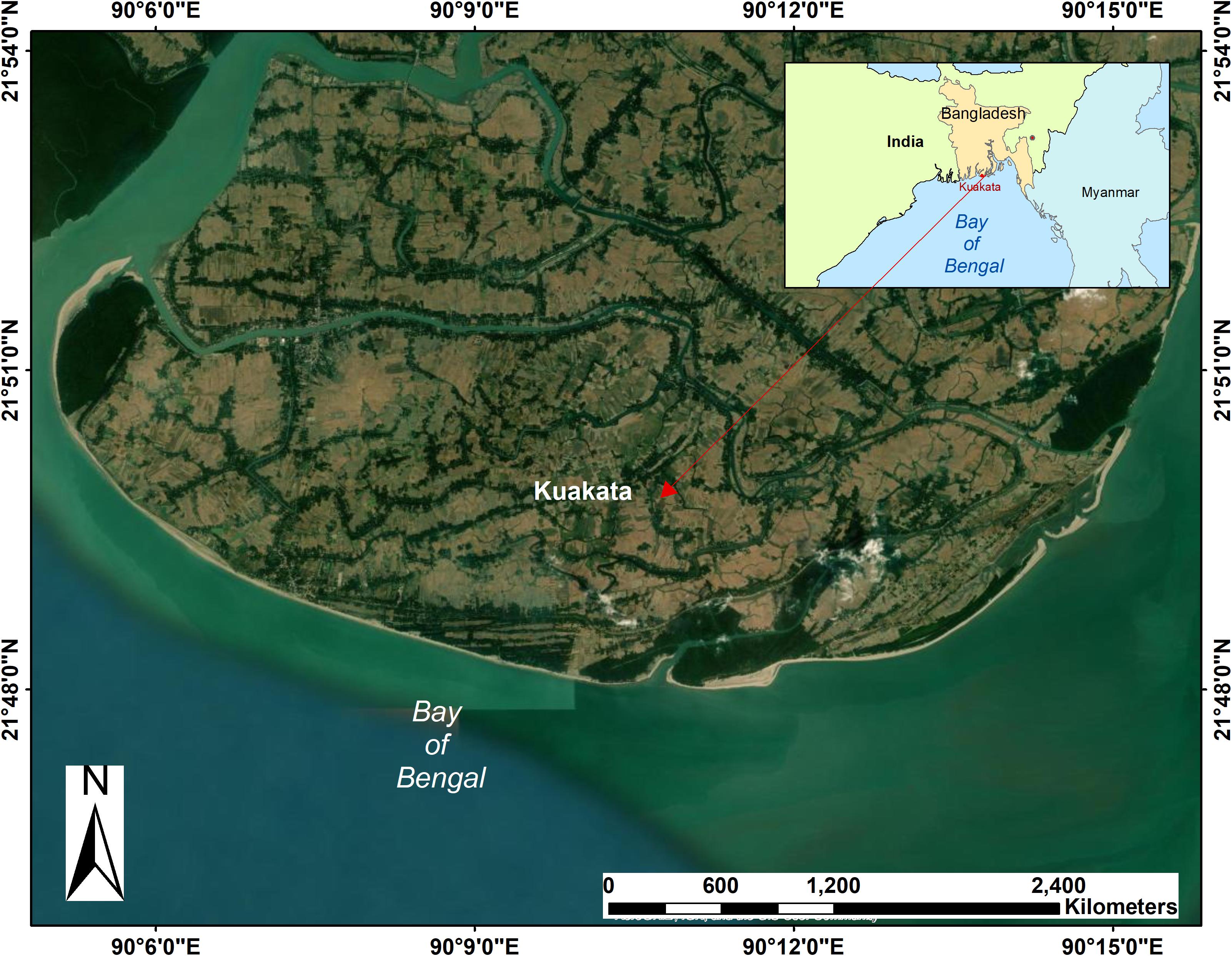
Figure 1. Location of study area.
From a human-environment-interactions perspective, Kuakata is an economically active zone that offers access to fisheries and commerce, proximity to rich agricultural lowlands, and recreational opportunities, which form the basis for economic opportunities for a large community. The percentages of jobs in agriculture, fishing, commerce, service, agricultural laborer, wage laborer, and “other” in this region are approximately 45.6, 5.7, 10.0, 3.6, 18.9, 4.6, and 11.7, respectively (Bangladesh Bureau of Statistics, 2009). While 19 percent of Kuakata’s land is classified as agricultural, this percentage is decreasing gradually, as the land is in high demand for commercial development, particularly by the recently emerging tourism industry. The inland area of Kuakata is protected from tidal waves by an earthen flood embankment, which was constructed few hundred meters away from the shoreline (Rahman et al., 2013). The extension of the embankment/levee and newly created roads has increased this demand further.
The shoreline change is detected over an approximately four-decade interval by comparing satellite imagery from 12 January 1989, 19 December 2003, and 30 January 2010 using Landsat Thematic Mapper (TM) imagery, and 11 February 2020 using Landsat 8 Operational Land Imager (OLI) and Thermal Infrared Sensor (TIRS) satellite images, all at 30 m resolution. These dates are selected to enhance shoreline delineation by balancing the needs for clear sky cover, low tides, and maintenance of a similar time in the dry season, all amid the limitation of a once-in-sixteen-day flyover by the satellite sensor (United States Geological Survey (USGS), 2021). For unavoidable cases of tidal interference, tidal data are used to verify the tidal condition at the acquisition time, and the exact shore line position is determined by adding or subtracting the tidal data. Although several tidal stations managed by the Bangladesh Water Development Board exist, none with reliable, continuous records are located on Kuakata. Mirzaganj (Station ID—SW19), located ∼61.0 km northwest from the study area, is the nearest tidal station with a continuous record of the daily semi-diurnal tidal conditions, ranging from 0.01 m at neap tide to 2.04 m at spring tide at the Barisal-Buriswar River; its data are applied to approximate the tidal condition at the image acquisition time.
Band Combination (BC; Dwivedi and Rao, 1992; Sutikno et al., 2020), Ratio Transformation (RT; Mavraeidopoulos et al., 2019), Normalized Difference Vegetation Index (NDVI; Carlson and Ripley, 1997; Huang et al., 2021), and Normalized Difference Water Index (NDWI; Gao, 1996; Su et al., 2021) algorithms are often used to extract the shoreline from the land/water boundary. Among the four methods of shoreline detection, BC—a method of combining bands with wavelengths of the electromagnetic spectrum sensitive to shoreline detection, is selected primarily because of its higher accuracy of boundary-matching with the already georeferenced, cross-checked Local Government Engineering Department (LGED) maps. For the BC method, combining the TM’s Bands 4 (0.76–0.90 μm), 5 (1.55–1.75 μm), and 7 (2.08–2.35 μm), and Bands 5 (0.85–0.88 μm), 6 (1.57–1.65 μm), and 7 (2.11–2.29 μm) for OLI and TIRS, provides the best result for shoreline detection (United States Geological Survey, 2020). This is because these bands operate in the best spectral region to emphasize land-water contrast, distinguishing water bodies in a darker tone from other land use categories in a lighter tone. This sets a sharp contrast between the land-water boundary, as for both Landsat Image types Band 7 spectral has a strong water absorption region and a strong reflectance region for soil and rock, thereby causing water bodies to appear in dark tones and exposed land surfaces to appear in bright tones. Thus, the combination of these three bands results in the most accurate and distinct shoreline boundary. A minimal percentage of inaccuracy in boundary detection may be caused by diurnal tidal variations, vegetation coverage, and indistinguishable land-water area in Landsat satellite images.
The accuracy of the extracted shorelines is verified with georeferenced standard maps collected from the LGED of Bangladesh. The position is also cross-checked with the recorded ground control point (GCP) data, which are used for quality control. Also, 2010 is considered as the reference year to detect shoreline change.
The GIS and RS tools, Integrated Land and Water Information System (ILWIS) and ArcGIS® Desktop, are used for image processing, geometric correction, visual interpretation, and manual digitization to develop a vector data series for each of the images, to compare and measure the changes. The vector line dataset enables the comparison of shoreline shift over the years and vector polygon data series facilitates measurement of the rate of shoreline accretion and erosion using GIS tools. Application of GIS and RS is also required for ground truthing, which is done by conducting field verifications and GCP data collection using Global Positioning System (GPS) for more accurate measurements. The RS-GIS technique tests and quantifies the information collected from PRA tools.
Most research on shoreline change is directed toward using technical tools and applications rather than incorporating the human perceptive. PRA (Chambers, 1994; Kukielka et al., 2016), a growing family of research methods, involves a series of qualitative multidisciplinary approaches to learning about local-level conditions and individual perspectives based on first-hand knowledge, experiences, and intergenerational accumulated wisdom. The PRA tools described below were implemented in 2010 to elucidate the major causes and impacts of coastline shifting associated with the different natural settings and livelihoods, including forest, agriculture, aquaculture, fishing, fish drying, sea salt production, and trading. The PRA employed here relies on field observations and group meetings with communities and stakeholders, such as fisherman, farmers, small business owners, and tourism-related employees. More specifically, PRA verifies the results through a transect walk (Dooley et al., 2018; Schäffler et al., 2021), timeline (historical mapping) analysis (Mueller et al., 2010; Tomlinson et al., 2018), cause and effect diagram (Holme and Chalauisaeng, 2006; Saja et al., 2021), key informant interview (KII; Chenais et al., 2015; Balgah, 2016; Nicholson and Valentine, 2019; Dureab et al., 2021; Roothaert et al., 2021), and focus group discussion (FGD; Shamsuddin et al., 2007; Ng et al., 2021). These tools emphasize the following questions: What is the perception about shoreline change along the coast of Kuakata? What is the rate of this change? Is the face of change (i.e., erosion or accretion) happening similarly along the entire coast? What natural and/or anthropogenic features are affecting the rate of change? How have the local people adopted their livelihood to this change? What is the impact of this change?
The main aim of the transect walk is to observe land use from the 30 m buffer zone of the Bay of Bengal to 500 m inland. Six transect walks were conducted in the central and western-central parts of the island while avoiding the mangrove forests and sand dune piles. The land use pattern is generalized to a cross section profile, with the help of pre-downloaded Google imagery, GPS, and local knowledge, to convey the impact of shoreline change on coastal land use and livelihood patterns.
The timeline analysis is designed to appraise the historical change in people’s observations. This analysis facilitates acquisition of substantive qualitative information regarding the chronology of shoreline change in a short amount of time across a remote area poorly covered by PRA study. The timeline analysis is based on the assumption that to understand past events it is necessary to identify the shoreline location over time, cause of changes, and impacts due to the change. Twelve people, in groups of six, participated in drawing the relative shoreline positions over time, from that provided to them in a timeline table. They then offered their opinions on the causes and impacts of the changes. The majority (i.e., four to five from each group) of the participants were fishermen who live near the coast. Based on the common responses from the two groups, numbers in the table have been reported.
The cause and effect diagram is also implemented to assess causes of changes and their impacts, based on the participant opinions. It involves a visual tool to help the participants to compare the relative importance of the causes and effects due to shoreline change in a tree-like diagram where the consequences (effects) of shoreline change are represented by the trunk of the tree diagram, while physical mechanisms (causes) which result from those consequences by accelerating shoreline change are shown as roots. Three different groups (one with ten fishermen, another group of ten farmers, and six small businessmen associated with tourism activities) participated separately to complete the tree diagram.
The purpose of the KII is to assign local specification of the consequences and investigate common impacts and adaptation measures. Relying on the list of issues found from the transect walk, timeline analysis, and cause and effect diagram, a descriptive question structure was formed to allow free flow of information for collecting in-depth and spontaneous responses from the two key interviewees about the shoreline change that they have observed over the years and its impact on the community’s livelihood. The key informants are from two different backgrounds who were interviewed individually, after obtaining their written consent, to determine their perceptions of the causes of shoreline change and its impacts on local people. At the time, one of the interviewees was a surveyor with 35 years of professional experience regarding land use survey and land use change. Another key informant was a land developer and was still working there for a land reclamation project. Notes taken during the interview process were evaluated and elaborated shortly afterward.
Finally, one group of ten fishermen and a separate group of ten farmers participated in two FGDs, as it became apparent that they are the primary victimized occupational groups from the change of shoreline. They were asked whether they have noticed coastal accretion or erosion and the effects or impacts of this land change.
The Kuakata shoreline has shifted inward (Figure 2). The central and eastern regions have a retrograding shoreline on a net basis, and the western part of the western region of the island has an elongating shoreline, likely owing to fluvial deposition. The BC method reveals that erosional activity is more prominent than accretional activity. The western horn of the island is elongating because of accretion. In the central and eastern coast both erosional and accretional processes have taken place to modify the coastline. The shoreline change implies that Kuakata’s seaward coast is dominated by the effects of erosional activities and/or sea level rise. Approximately 13.59 km2 of land has been lost, and 3.27 km2 land has been gained since 1989, resulting in a net loss of 10.32 km2 of land over the last four decades. The fastest accretion rate across the study period is for the eastern zone, at 0.05 km2 yr–1 (Table 1), despite a net shoreline retreat. The central zone has the most rapid erosion rate, at 0.19 km2 yr–1 and the strongest net rate of shoreline retreat (Table 1), likely because of less fluvial impact and marine influence.
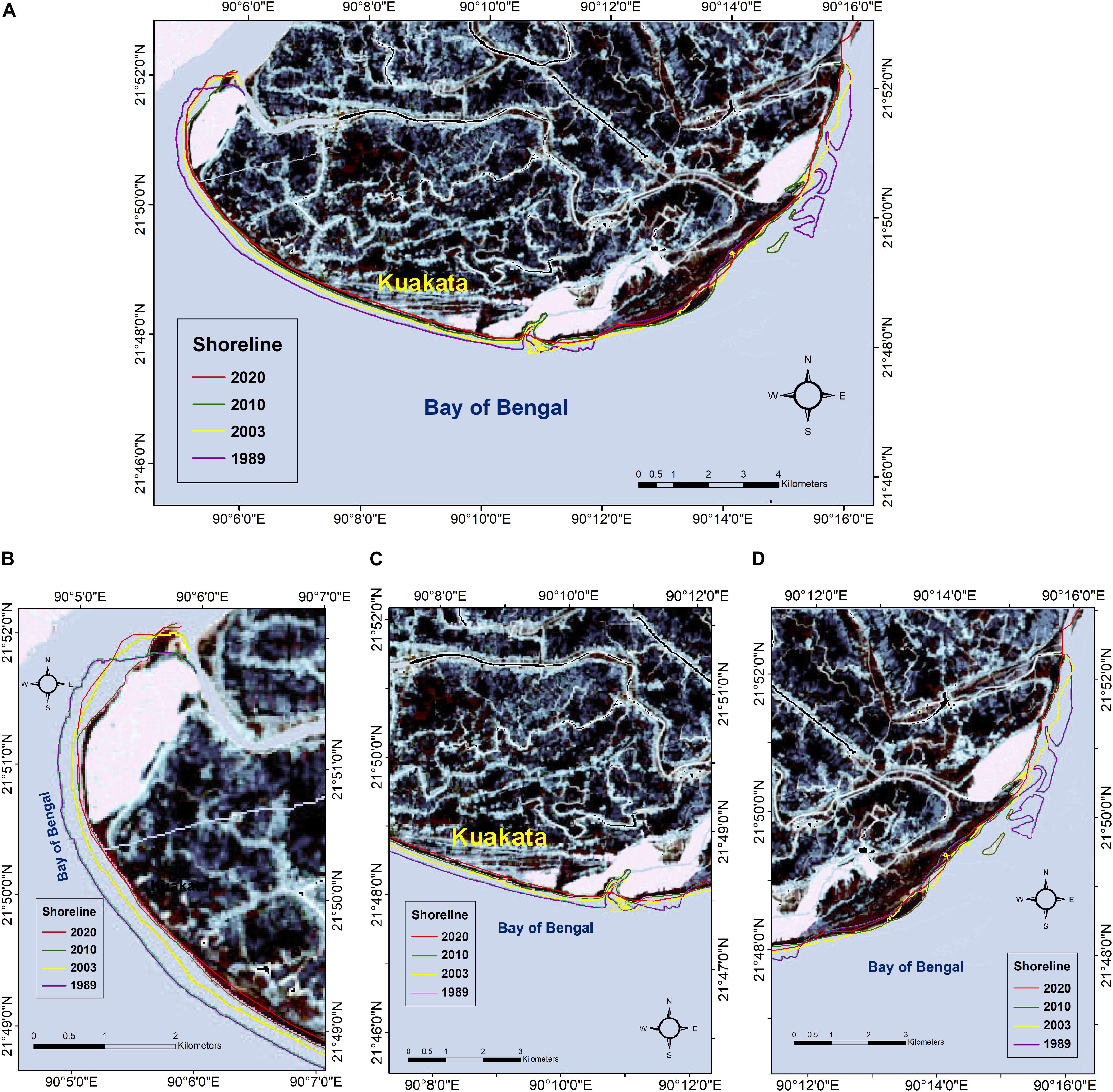
Figure 2. Position of Kuakata’s seaward shoreline by year; (A) overall, (B) western, (C) central, and (D) eastern part of the study area. Notice the elongating shoreline in the western extreme of the western zone, and the unevenness of the retreat over time, particularly in the eastern zone.

Table 1. Measurements of coastal land area changes by accretion and erosion (in km2).
Comparison between the range of years 1989–2003, 2003–2010, and 2010–2020 provides a more detailed perspective. The erosion rate from 2003 to 2010 (0.76 km2 yr–1) exceeded that from 1989 to 2003 (0.46 km2 yr–1) and 2010 to 2020 (0.18 km2 yr–1). At the same time, the accretion rate was less from 2003 to 2010 (0.07 km2 yr–1) than from 1989 to 2003 (0.13 km2 yr–1) and 2010 to 2020 (0.09 km2 yr–1). Thus, land loss from 2003 to 2010 exceeded that from 1989 to 2003 and 2010 to 2020. For the entire range of years (i.e., from 1989 to 2020), the erosion rate was 0.44 km2 yr–1, and the rate of accretion was 0.11 km2 yr–1. These relationships are depicted graphically by region in Figure 3, with specific locations where net accretion and erosion occurred during the sub-intervals shown in Figure 4. Only very small coastal areas, mostly in the west, have net accretion, with net erosion elsewhere. The results corroborate those of other studies (Shibly and Takewaka, 2012; Bushra, 2013; Islam et al., 2013; Mitra et al., 2013; Rahman et al., 2013) which concluded that erosion dominates over accretion in this region. For example, Islam et al. (2013) found that from 1973 to 2012 the erosion rate was 0.29 km2 yr–1, and the rate of accretion was 0.09 km2 yr–1 in the Kuakata.
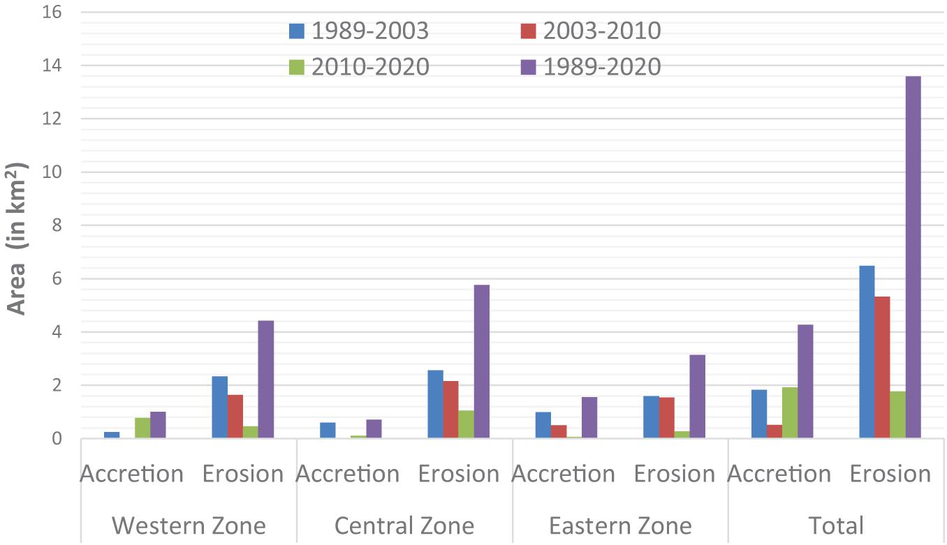
Figure 3. Kuakata coastal land area changes by zone (from 1989 to 2020).
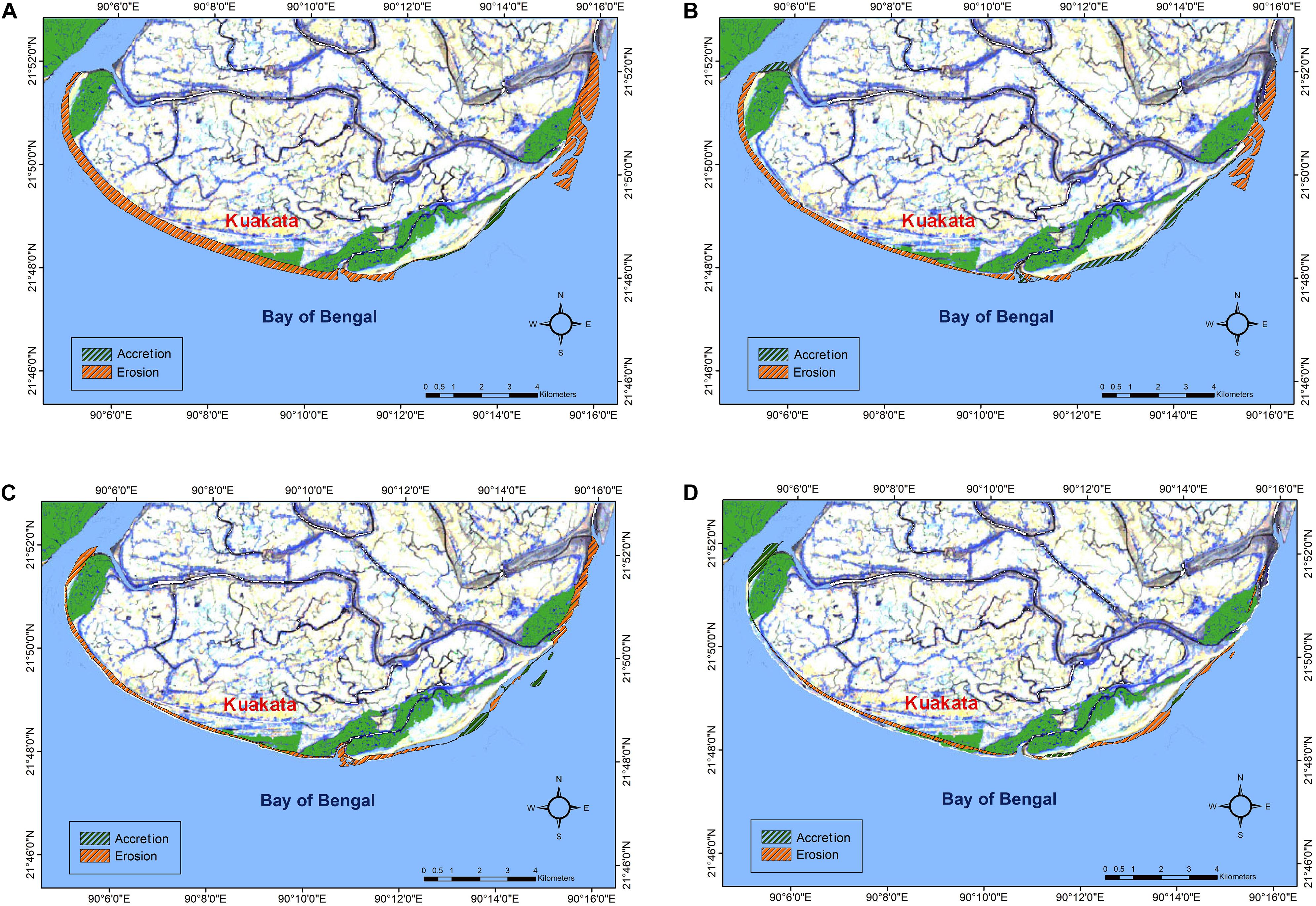
Figure 4. Erosion and accretion at Kuakata coast from (A) 1989 to 2020, (B) 1989 to 2003, (C) 2003 to 2010, and (D) 2010 to 2020. Notice the very small coastal areas, mostly in the west, of net accretion, and net erosion elsewhere.
In addition to the satellite image study and geospatial interpretation, The PRA tools described in the previous sections provide new information.
Figure 5 summarizes the results of the transect walk. According to the local people, the establishment of embankments since 1966 and the presence of fluvial tidal creeks, canals, and sand dunes have important roles in maintaining the stable shoreline in the central zone and accretion in the eastern zone. The locals believe that the western part is protected by a newly formed extension of the embankment which was built after Cyclone Aila destroyed the previous one in 2009, and even though erosion still persists, the rate is less than in years before embankment construction. The satellite imagery confirms this observation, as for the western zone over the 2010–2020 period, erosion was 0.46 km2, but over the 1989–2003 and 2003–2010 periods it was 2.33 km2 and 1.63 km2, respectively. During the transect walk, the local community confirms that among all major economic activities fishing and tourism were affected most by shoreline erosion.
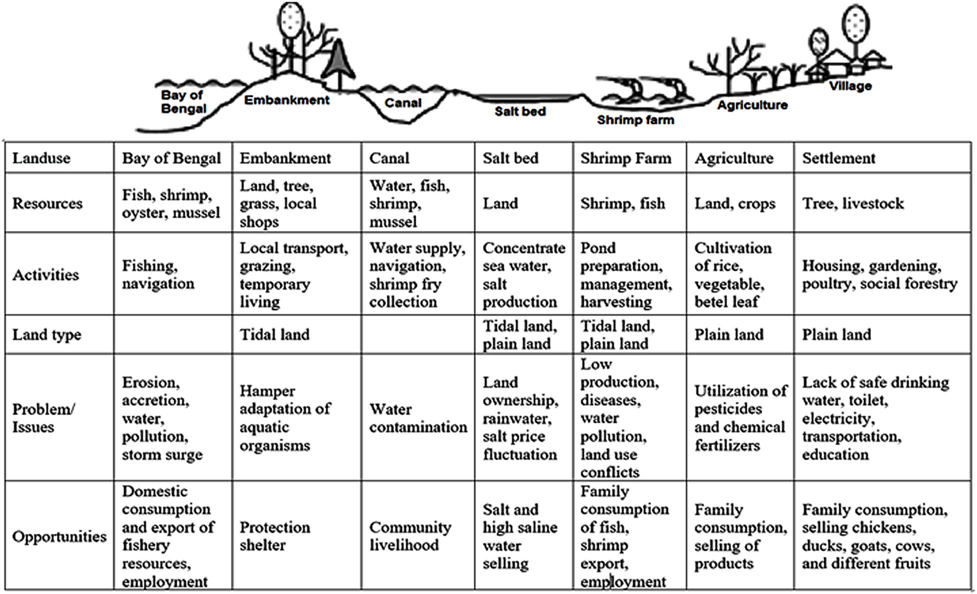
Figure 5. Transect walk analysis showing land use patterns in central Kuakata.
The timeline analysis reveals that except for the Cauer Char (L8) area (Figure 6), which is situated at the eastern side of the landmass, the shoreline has retreated inland substantially (Table 2). This finding corroborates the results from the satellite imagery analysis. According to the local people, at Lebur Char (L1) and Khajura (L2), the shoreline had been reduced by about 7–8 km from 1989 to 2003 and about 2.5 km from 2003 to 2010. The Computer (L3) and Mirabari (L4) areas had shown nearly the same amount of erosion for 1989–2003 and about 1.5–2.5 km of erosion for 2003–2010. In comparison to the above area, the Ghatla (L5), Jhauban (L6), and Gangamoti (L7) locations had less shoreline erosion, which was about 5 km for the years 1989–2003 and 1–7.5 km for 2003–2010. Though the Cauer Char (L8) did not exist in 1989, its establishment was prominent in 2003, and it became extended by about 2 km from 2003 to 2010.
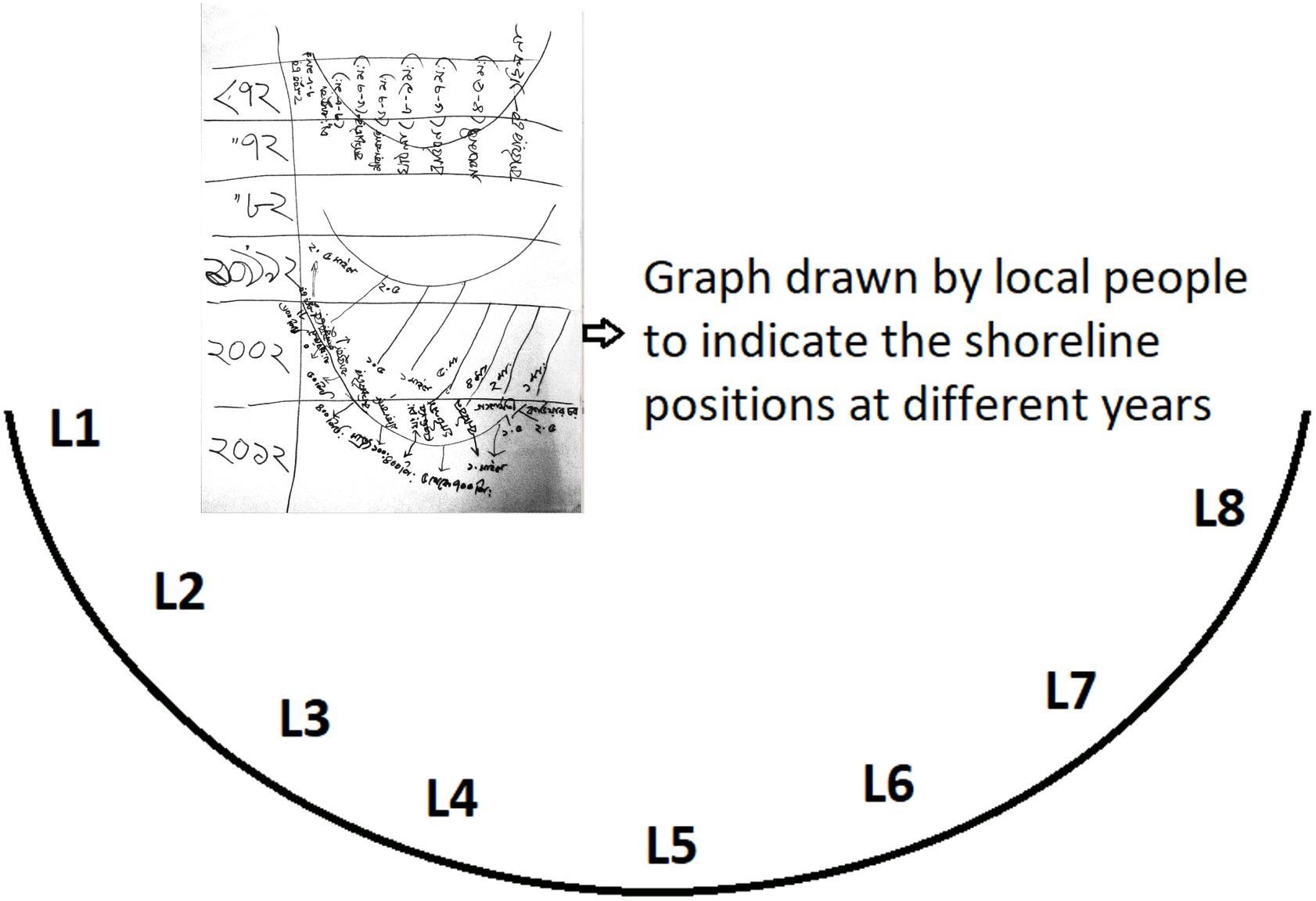
Figure 6. Comparative position of local places along the shoreline according to the local people.
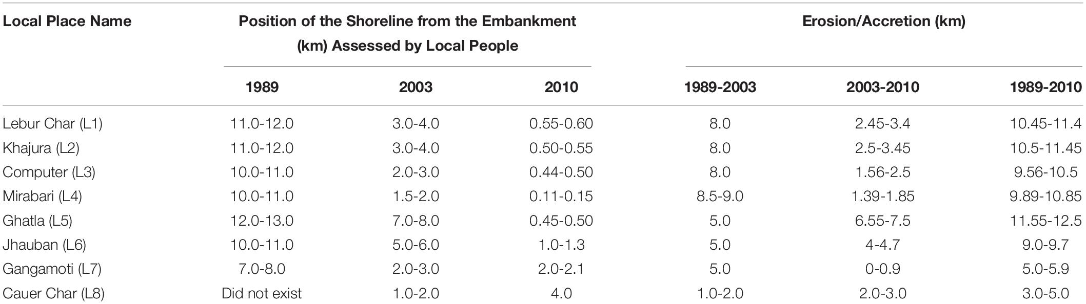
Table 2. Tentative positions of the shoreline at different locations from the embankment, according to the timeline analysis by local people.
Both RS-GIS and PRA outcomes (Tables 1, 2) establish that in the western (Lebur Char, Khajura, and Computer) and central (Mirabari, Ghatla, and Jhauban) zones, erosional activity is dominating over accretion. The concave shape of the coast also explains why the central zone is more responsive to these factors. In the eastern zone (Cauer Char), accretion is dominating. These findings corroborate those of Rahman et al. (2013), who found that from 1973 to 2010 the western part of Kuakata beach suffered an average erosion of 350–450 m. Table 2 shows that, on average from 1989 to 2010, the erosion rate in Lebur Char, Khajura, and Computer is approximately 500 m yr–1.
The cause and effect diagram (Figure 7) depicts the main causes of shoreline change in that locality, as expressed by community members. Most prominent among the community-identified causes are marine and climatic actions for shoreline erosion, including tide, current, wave actions, tidal flood, cyclone, storm surges, and sea level rise. A few people mentioned that in some parts of Kuakata, accretion activities caused by sedimentation by fluvial and marine actions and landform structure are occurring. This accretion occurs along the low gradient and gentle slope of the continental shelf and is enhanced by construction of the embankment and polders at the coastal boundary. Landfilling at the shoreline boundary and destruction of sand dunes, which accelerate the wave/wind action inland, are also the causes for shoreline modification at the coastal boundary. Respondents concur that the shoreline is mainly retreating, but there are some accretional activities in some parts of the lands where the fluvial and marine processes have deposited sediments over the last 20 years. The main causes of shoreline change and their subsequent effects are listed in Table 3.
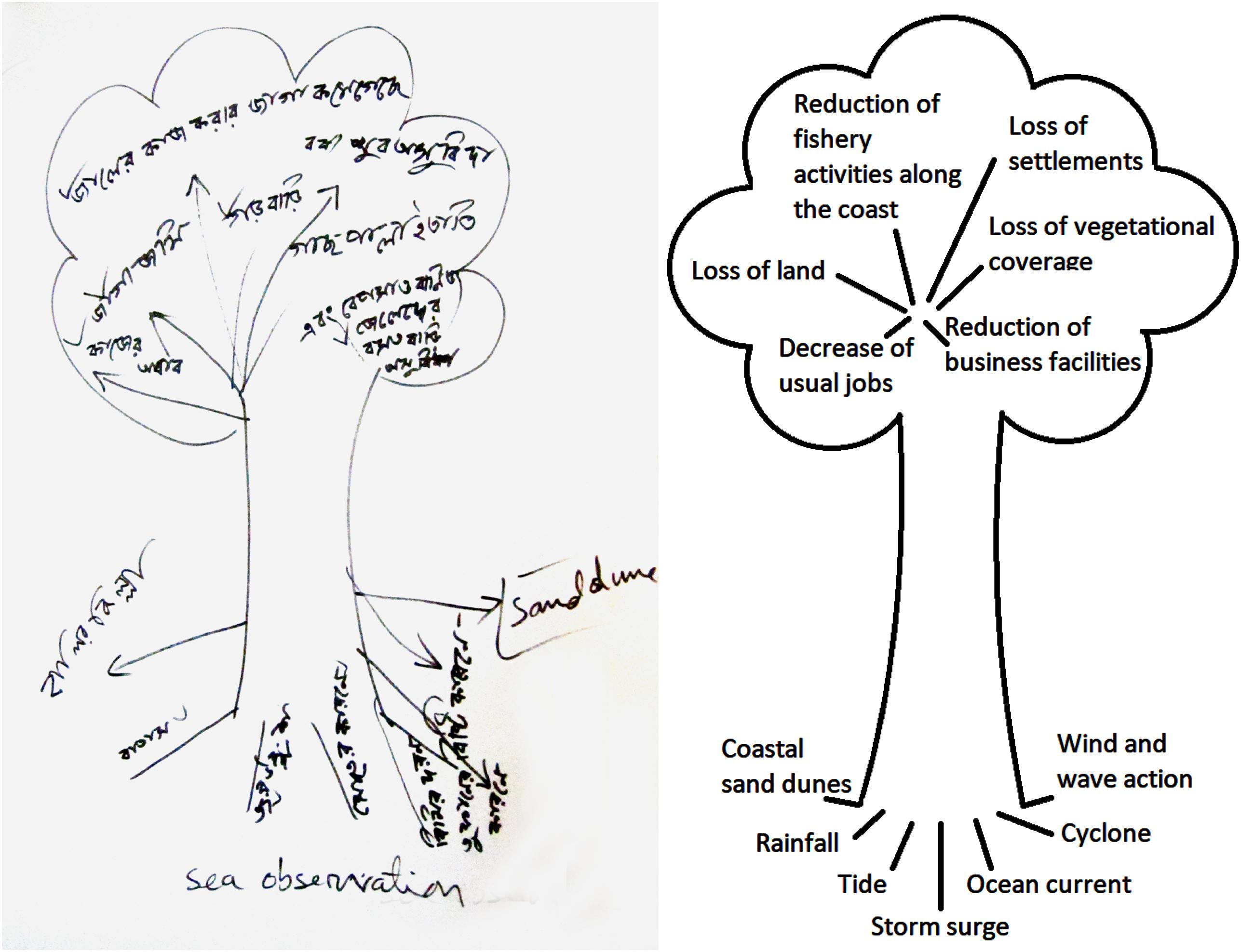
Figure 7. Cause and effect diagram by the local community living along the Kuakata coast.
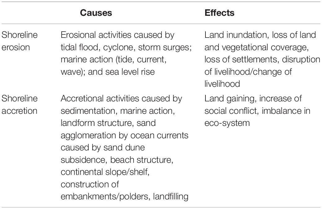
Table 3. Major causes and their subsequent effects of shoreline change on the Kuakata coast.
The key informant who was a surveyor expressed that poor coastal management, monitoring, and maintenance are among the causes of coastal land degradation and land loss, rather than natural processes. The informant who at the time was a land developer expressed that by being a famous tourist spot in Bangladesh, land reclamation has accelerated over the last 30 years, and that initially no one monitored the process of land cover change for commercial purposes (i.e., building hotels, resorts, and shopping complexes). That same informant noted that the excavation of sand from the sea was also destroying many dune fields. The informant also noted that these are common occurrences for the development of many hotels along the beachside. Such activities ultimately result in disruption of the natural processes and acceleration of coastal erosion. Both key informants agree that the lack of planning and proper implementation of laws and legislation for coastal management and maintenance are responsible for this coastal land degradation. Although the government has undertaken some initiatives to maintain this famous tourist spot, land reclamation by the developer and the development of high-rise buildings continues.
According to the fishermen in the FGD, marine waves, ocean currents, and tides are the major causes of shoreline change. The participants felt that these regular phenomena are more prevalent during the monsoon season, which causes land loss and shoreline erosion. In addition to these regular phenomena, the recent increase in the frequency of coastal cyclones and in the intensity of storm surge (Bushra, 2016; Bushra et al., 2019) and tidal flooding have accelerated the erosional process along the coast. As these phenomena destroy the vegetation coverage, sand dune fields, and sand piles along the coast, the erosional effects of regular waves, currents, and tides are exacerbated. Because the seasonal winds typically blow from the southwest, the erosional activities are more prominent along the west coast of Kuakata. Thus, the fishing community has less buffer zone around the seashore for their fishing activities.
The farmers noted that as the sea encroaches on their homeland, they themselves become more dependent on shrimp cultivation rather than cropping. According to the respondents, saltwater intrusion complicates the problem even more. As the sea is advancing, windblown sand from the beach has become so abundant on their fertile land that it can become uncultivable. The farmers who have land near the coast sometimes face enormous pressure from land developers and are sometimes swindled into selling their land to occupiers. They have also mentioned that the establishment of the embankment has acted as a barrier to many tidal creeks and canals inland, causing flow diversion or discontinuous and reduced flow sedimentation. These problems invite further unobstructed encroachment by the sea.
While fluvial processes contribute considerably to seaward shoreline advancement through delta building, embankment/levee construction has hindered that process. On the other hand, establishment of the embankment reduces coastal erosion from waves, tides, ocean currents, and storm surges, thus protecting the coast from marine processes. It is difficult to evaluate which processes—fluvial or marine—contribute more toward coastal land formation and therefore the shoreline change. Not surprisingly, farmers emphasized the fluvial processes, which bring sediments to nourish their agricultural lands, while the fishermen are more concerned about marine processes.
Shoreline change in Bangladesh has great implications regarding coastal ecosystem health, biodiversity, economic livelihood, and land use practices. The people of the coastal area face the consequences of this change. Precise determination of the shoreline rates of change is needed to prepare for coastal hazards, risks, and land use planning (Nicholls and Klein, 2005).
Comparison between the shorelines of satellite images consistently showed that on a net basis from 1989 to 2020, erosional activity on the Bangladesh coast is more prominent than accretional activity. Regionally erosional, activity is more prominent in the western and central zone, and accretion occurs more in the eastern zone. Even though erosion was greater in the central zone (5.76 km2) over the same period, it decreased gradually over time. Thus, spatial analysis along with the temporal representation of the dynamic coastline of Kuakata signifies that western and central parts of the shoreline are shifted inward noticeably. From 1989 to 2020, 3.27 km2 of coastal land has been gained while 13.59 km2 of land has been eroded across the Kuakata coastline. These results support those from previous research (Shibly and Takewaka, 2012; Bushra, 2013; Islam et al., 2013; Mitra et al., 2013; Rahman et al., 2013) that suggested that the shoreline retreat had been occurring in this area at least up to 2012. On a more encouraging note, in the last decades the accretion rate has increased and the erosion rate has decreased from the previous decades.
Application of PRA supports the quantitative results of shoreline change from satellite imagery by addressing the impacts of erosion, accretion, and stable shoreline along the Kuakata coast qualitatively. PRA provides information regarding the basis of this erosion and accretion and their effects on the coastal livelihood pattern. The implementation of PRA tools establishes the basis for describing the extent of economic and environmental effects of present shoreline erosion and accretion. PRA results imply that the establishment of the embankment protects the zones from erosional activities, while the presence of fluvial tidal creeks and sand dunes plays a greater role for the stable zones. Economic activities, especially fishing and tourism, are affected by the erosional effects of shoreline change. The local people identify marine and climatic factors as the main causes of the shoreline change. The key informants reported that monitoring and proper management are needed for future maintenance of the coast as the coastal area has attracted the attention of land developers, particularly because of the area’s desirability as a tourist resort. Over the years, coastline retreat inland reduces the fishing activity while agricultural lands are also diminishing due to saltwater intrusion, loss of fertility due to sand aggregation and canals/creeks diversion, and land reclamation by the developer for commercial purposes. Collectively the information from this PRA implies that, on a net basis, the rate of erosion exceeds that of accretion along the coast of Kuakata. The PRA result that shoreline change, specifically shoreline erosion, is such a concern, particularly due to its continuation over the years, provides hope that proper land management strategy, policy implementation, and appropriate risk reduction approaches, as well as social, behavioral, and communal responses, may be successful.
Accurate shoreline delineation is needed for application sciences (e.g., ship navigation, environmental change management, coastal development, and flood prediction). A comprehensive shoreline change analysis and its impact can be evaluated by applying technological approaches accompanied by on-the-scene input from local community members who observe the changes and their impacts daily. This research is important not only for measuring shoreline change over time, but for policy makers and land use managers for future land use planning related to costal shoreline change. Next steps in effective analysis may include monitoring the shoreline by means of repeated surveys to correct the seasonal variability induced by intense storms, with public input. More efficient methods for data extrapolation would reach an effective compromise between accuracy, cost, and time. Regardless, however, effective monitoring requires the development of technologies and social science approaches capable of providing useful contributions to enhance sustainability of this important coastal environment.
The raw data supporting the conclusions of this article will be made available by the authors, without undue reservation.
NB developed the methodology, collected and analyzed the data, and developed the initial text. RM provided assistance in data collection, organized the manuscript, edited the text, and revised the text to conform to reviewer recommendations. RR edited initial and late drafts of the text. CF revised the text. MR verified the calculations and edited the text. All authors contributed to the article and approved the submitted version.
This project has been completed as a requirement of a degree program under South Asian Water (SAWA) Fellowship Programme.
The authors declare that the research was conducted in the absence of any commercial or financial relationships that could be construed as a potential conflict of interest.
All claims expressed in this article are solely those of the authors and do not necessarily represent those of their affiliated organizations, or those of the publisher, the editors and the reviewers. Any product that may be evaluated in this article, or claim that may be made by its manufacturer, is not guaranteed or endorsed by the publisher.
We appreciate the assistance and support of A.K.M. Saiful Islam and Mashfiqus Salehin, professors of the Institute of Water and Flood Management (IWFM), Bangladesh University of Engineering and Technology (BUET), and Md. Ali Haider, Assoc. Prof., Department of Geography and Environmental Studies, University of Chittagong, for their guidance and suggestions throughout the course of this project work, and Kuakata’s local people for their assistance in collecting field data and participating in PRA methods.
Ahmed, A., Drake, F., Nawaz, R., and Woulds, C. (2018). Where is the coast? Monitoring coastal land dynamics in Bangladesh: an integrated management approach using GIS and remote sensing techniques. Ocean Coast. Manag. 151, 10–24. doi: 10.1016/j.ocecoaman.2017.10.030
Akter, J., Sarker, M. H., Popescu, I., and Roelvink, D. (2016). Evolution of the Bengal Delta and its prevailing processes. J. Coast. Res. 32, 1212–1226. doi: 10.2112/JCOASTRES-D-14-00232.1
Alam, G. M., Alam, K., Mushtaq, S., and Filho, W. L. (2018). How do climate change and associated hazards impact on the resilience of riparian rural communities in Bangladesh? Policy implications for livelihood development. Environ. Sci. Policy 84, 7–18. doi: 10.1016/j.envsci.2018.02.012
Ali, A. (2000). Vulnerability of Bangladesh Coastal Region to Climate Change with Adaptation Options. Dhaka: Bangladesh Space Research and Remote Sensing Organization (SPARRSO), 34–58.
Amin, S. M. N. (2008). Studies on Coastal Environments in Bangladesh. House: A.H. Development Publishing.
Balgah, R. A. (2016). Applying participatory rural appraisal to unlock gender group differences in some communities in rural Cameroon. Asian J. Agric. Ext. Econ. Sociol. 12, 1–11. doi: 10.9734/AJAEES/2016/28327
Bangladesh Bureau of Statistics (2009). Statistical Yearbook of Bangladesh. Ministry of Planning, Government of Bangladesh, Dhaka, Bangladesh. Available online at: http://203.112.218.65:8008/PageSiteMap1.aspx?MenuKey=7 (accessed July 18, 2021).
Barbaro, G., Fiamma, V., Barrile, V., Foti, G., and Ielo, G. (2017). Analysis of the shoreline changes of Reggio Calabria (Italy). Int. J. Civil Eng. Technol. 8, 1777–1791.
Barillà, G. C., Foti, G., Barbaro, G., and Puntorieri, P. (2020). “Shoreline changes of a pocket beach: a remote sensing application, Proc. SPIE 11524,” in Proceedings of the 8th International Conference on Remote Sensing and Geoinformation of the Environment (RSCy2020), Vol. 11524(Bellingham, WA: International Society for Optics and Photonics), 1152425. doi: 10.1117/12.2571212
Boak, E. H., and Turner, I. L. (2005). Shoreline definition and detection: a review. J. Coast. Res. 21, 688–703. doi: 10.2112/03-0071.1
Bomer, E. J., Wilson, C. A., and Datta, D. K. (2019). An integrated approach for constraining depositional zones in a tide-influenced river: insights from the Gorai River, Southwest Bangladesh. Water 11:2047. doi: 10.3390/w11102047
Brammer, H. (2014). Bangladesh’s dynamic coastal regions and sea-level rise. Clim. Risk Manag. 1, 51–62. doi: 10.1016/j.crm.2013.10.001
Brammer, H., Asaduzzaman, M., and Sultana, P. (1996). “Effects of climate and sea-level changes on the natural resources of Bangladesh,” in The Implications of Climate and Sea–Level Change for Bangladesh, eds R. A. Warrick and Q. K. Ahmad (Dordrecht: Springer), 143–203. doi: 10.1007/978-94-009-0241-1
Broadus, J. M. (1993). “Possible impacts of, and adjustments to, sea level rise: the case of Bangladesh and Egypt,” in Climate and Sea Level Change: Observations, Projections and Implications, eds R. A. Warrick, E. M. Barrow, and T. M. L. Wigley (Cambridge: Cambridge University Press), 263–275.
Brodnig, G., and Mayer-Schönberger, V. (2000). Bridging the gap: the role of spatial information technologies in the integration of traditional environmental knowledge and western science. Electron. J. Inf. Syst. Dev. Ctries. 1, 1–15. doi: 10.1002/j.1681-4835.2000.tb00001.x
Bushra, N. (2013). Detecting Changes of Shoreline at Kuakata Coast Using RS-GIS Techniques and Participatory Approach. Post Graduate Diploma Project, Institute of Water and Flood Management, Bangladesh University of Engineering and Technology. Available online at: http://lib.buet.ac.bd:8080/xmlui/handle/123456789/4186 (accessed June 24, 2021).
Bushra, N. (2016). Modeling Tropical Cyclone Storm Surge and Wind Induced Risk along the Bay of Bengal Coastline Using a Statistical Copula. LSU Master’s Thesis. 251. Available online at: https://digitalcommons.lsu.edu/gradschool_theses/251 (accessed July 18, 2021).
Bushra, N., Islam, M. S., and Khan, A. U. (2014). Natural processes on coastal sand dune dynamics of Kuakata: a geographical analysis. Dhaka Univ. J. Earth Environ. Sci. 3, 9–14.
Bushra, N., Islam, M. S., and Khan, A. U. (2016). Dune morphology of Kuakata coast in Bangladesh. J. NOAMI 33, 91–102.
Bushra, N., Trepanier, J. C., and Rohli, R. V. (2019). Joint probability risk modelling of storm surge and cyclone wind along the coast of Bay of Bengal using a statistical copula. Int. J. Climatol. 39, 4206–4217. doi: 10.1002/joc.6068
Carlson, T. N., and Ripley, D. A. (1997). On the relation between NDVI, fractional vegetation cover, and leaf area index. Remote Sens. Environ. 62, 241–252. doi: 10.1016/S0034-4257(97)00104-1
Center for Climate Systems Research and The Earth Institute of Columbia Climate School (2006). It’s 2025. Where do most people live? Available online at: https://www.earth.columbia.edu/articles/view/919 (accessed July 18, 2021).
Centre for Environmental and Geographic Information Services (CEGIS) (2009). Monitoring Platform Developments in the EDP (Estuary Development Program) Area Using Remote Sensing, Dhaka, Bangladesh. Available online at: https://www.cegisbd.com/ (accessed July 18, 2021).
Chambers, R. (1994). The origins and practice of participatory rural appraisal. World Dev. 22, 953–969. doi: 10.1016/0305-750X(94)90141-4
Chand, P., and Acharya, P. (2010). Shoreline change and sea level rise along coast of Bhitarkanika wildlife sanctuary, Orissa: an analytical approach of remote sensing and statistical techniques. Int. J. Geomatics Geosci. 1, 436–455.
Chen, L. C. (1998). Detection of shoreline changes for tideland areas using multi-temporal satellite images. Int. J. Remote Sens. 19, 3383–3397. doi: 10.1080/014311698214055
Chenais, E., Sternberg-Lewerin, S., Boqvist, S., Emanuelson, U., Aliro, T., Tejler, E., et al. (2015). African swine fever in Uganda: qualitative evaluation of three surveillance methods with implications for other resource-poor settings. Front. Vet. Sci. 2:51. doi: 10.3389/fvets.2015.00051
Deepika, B., Avinash, K., and Jayappa, K. S. (2014). Shoreline change rate estimation and its forecast: remote sensing, geographical information system and statistics-based approach. Int. J. Environ. Sci. Technol. 11, 395–416. doi: 10.1007/s13762-013-0196-1
Dixon, T. H., Amelung, F., Ferretti, A., Novali, F., Rocca, F., Dokka, R., et al. (2006). Subsidence and flooding in New Orleans. Nature 441, 587–588.
Dooley, K. E., Dobbins, C., and Edgar, L. D. (2018). Using participatory rural appraisal for a community needs assessment in Timor-Leste. J. Int. Agric. Ext. Educ. 25, 63–73. doi: 10.5191/jiaee.2018.25405
Dureab, F., Hussain, T., Sheikh, R., Al-Dheeb, N., Al-Awlaqi, S., and Jahn, A. (2021). Forms of health system fragmentation during conflict: the case of Yemen. Front. Public Health 9:805. doi: 10.3389/fpubh.2021.659980
Dwivedi, R. S., and Rao, B. R. M. (1992). The selection of the best possible Landsat TM band combination for delineating salt-affected soils. Int. J. Remote Sens. 13, 2051–2058. doi: 10.1080/01431169208904252
Elkoushy, A. A., and Tolba, E. R. A. (2003). Prediction of Shoreline Change by Using Satellite Aerial Imagery. Available online at: https://www.isprs.org/proceedings/XXXV/congress/yf/papers/1.pdf (accessed June 24, 2021).
Emran, A., Rob, M. A., and Kabir, M. H. (2019). “Coastline change and erosion-accretion evolution of the Sandwip Island, Bangladesh,” in Environmental Information Systems: Concepts, Methodologies, Tools, and Applications (pp. 1497-1509), (Hershey, PA: IGI Global). Available online at: https://www.igi-global.com/chapter/coastline-change-and-erosion-accretion-evolution-of-the-sandwip-island-bangladesh/213005 (accessed July 18, 2021).
Ericson, J. P., Vörösmarty, C. J., Dingman, S. L., Ward, L. G., and Meybeck, M. (2006). Effective sea-level rise and deltas: causes of change and human dimension implications. Global Planet. Change 50, 63–82. doi: 10.1016/j.gloplacha.2005.07.004
Foti, G., Barbaro, G., Bombino, G., Fiamma, V., Puntorieri, P., Minniti, F., et al. (2019). Shoreline changes near river mouth: case study of Sant’Agata River (Reggio Calabria, Italy). Eur. J. Remote Sens. 52(Suppl. 4), 102–112. doi: 10.1080/22797254.2019.1686955
Gao, B. C. (1996). NDWI—A normalized difference water index for remote sensing of vegetation liquid water from space. Remote Sens. Environ. 58, 257–266. doi: 10.1016/S0034-4257(96)00067-3
Ghaderi, D., and Rahbani, M. (2020). Detecting shoreline change employing remote sensing images (Case study: Beris Port-east of Chabahar, Iran). Int. J. Coast. Offshore Eng. 3, 1–8.
Goodbred, S. L. Jr., and Kuehl, S. A. (1999). Holocene and modern sediment budgets for the Ganges-Brahmaputra river system: evidence for highstand dispersal to flood-plain, shelf, and deep-sea depocenters. Geology 27, 559–562.
Hanebuth, T. J. J., Kudrass, H. R., Linstädter, J., Islam, B., and Zander, A. M. (2013). Rapid coastal subsidence in the central Ganges-Brahmaputra Delta (Bangladesh) since the 17th century deduced from submerged salt-producing kilns. Geology 41, 987–990. doi: 10.1130/G34646.1
Holme, R., and Chalauisaeng, B. (2006). The learner as needs analyst: the use of participatory appraisal in the EAP reading classroom. Engl. Specif. Purp. 25, 403–419. doi: 10.1016/j.esp.2006.01.003
Huang, S., Tang, L., Hupy, J. P., Wang, Y., and Shao, G. (2021). A commentary review on the use of normalized difference vegetation index (NDVI) in the era of popular remote sensing. J. For. Res. 32, 1–6. doi: 10.1007/s11676-020-01155-1
Huq, S. U., Ahmed, A. U., and Koudstaal, R. (1996). “Vulnerability of Bangladesh to climate change and sea level rise,” in In Climate Change and World Food Security, ed. T. E. Downing Vol. 37, (Berlin: Springer), 347–379. doi: 10.1007/978-3-642-61086-8_14
Ikeuchi, H., Hirabayashi, Y., Yamazaki, D., Muis, S., Ward, P. J., Winsemius, H. C., et al. (2017). Compound simulation of fluvial floods and storm surges in a global coupled river-coast flood model: model development and its application to 2007 Cyclone Sidr in Bangladesh. J. Adv. Model. Earth Syst. 9, 1847–1862. doi: 10.1002/2017MS000943
Islam, A. Z. M. Z., Kabir, S. M. H., and Sharifee, M. N. H. (2013). High-tide coastline method to study the stability of Kuakata coast of Bangladesh using remote sensing techniques. Asian J. Geoinform. 13, 23–29.
Koeva, M., Stöcker, C., Crommelinck, S., Ho, S., Chipofya, M., Sahib, J., et al. (2020). Innovative remote sensing methodologies for Kenyan land tenure mapping. Remote Sens. 12:273. doi: 10.3390/rs12020273
Kukielka, E. A., Jori, F., Martínez-López, B., Chenais, E., Masembe, C., Chavernac, D., et al. (2016). Wild and domestic pig interactions at the wildlife–livestock interface of Murchison Falls national Park, Uganda, and the potential association with African swine fever outbreaks. Front. Vet. Sci. 3:31. doi: 10.3389/fvets.2016.00031
Kumaravel, S., Ramkumar, T., Gurunanam, B., Suresh, M., and Dharanirajan, K. (2013). An application of remote sensing and GIS based shoreline change studies–a case study in the Cuddalore District, East Coast of Tamilnadu, South India. Int. J. Innov. Technol. Explor. Eng. (IJITEE) 2, 211–215.
Maiti, S., and Bhattacharya, A. K. (2009). Shoreline change analysis and its application to prediction: a remote sensing and statistics based approach. Mar. Geol. 257, 11–23. doi: 10.1016/j.margeo.2008.10.006
Makota, V., Sallema, R., and Mahika, C. (2004). Monitoring shoreline change using remote sensing and GIS: a case study of Kunduchi area, Tanzania. Western Indian Ocean J. Mar. Sci. 3, 1–10.
Mavraeidopoulos, A. K., Oikonomou, E., Palikaris, A., and Poulos, S. (2019). A hybrid bio-optical transformation for satellite bathymetry modeling using sentinel-2 imagery. Remote Sens. 11:2746. doi: 10.3390/rs11232746
Mialhe, F., Gunnell, Y., Ignacio, J. A. F., Delbart, N., Ogania, J. L., and Henry, S. (2015). Monitoring land-use change by combining participatory land-use maps with standard remote sensing techniques: showcase from a remote forest catchment on Mindanao, Philippines. Int. J. Appl. Earth Observ. Geoinform. 36, 69–82. doi: 10.1016/j.jag.2014.11.007
Mitra, M. C., Rahman, M. A., and Bin-Shafique, S. (2013). “Erosion of Kuakata Beach and its protection by beach nourishment,” in Proceedings of the 23rd International Offshore and Polar Engineering Conference. International Society of Offshore and Polar Engineers. Available online at: https://onepetro.org/ISOPEIOPEC/proceedings-abstract/ISOPE13/All-ISOPE13/ISOPE-I-13-511/13516 (accessed July 18, 2021).
Mostafiz, R. B., Friedland, C. J., Rohli, R. V., and Bushra, N. (2020a). “Assessing property loss in Louisiana, U.S.A., to natural hazards incorporating future projected conditions,” in American Geophysical Union Conference, NH015-002. Available online at: https://ui.adsabs.harvard.edu/abs/2020AGUFMNH0150002M/abstract (accessed July 18, 2021).
Mostafiz, R. B., Friedland, C. J., Rohli, R. V., Gall, M., Bushra, N., and Gilliland, J. M. (2020b). Census-block-level property risk estimation due to extreme cold temperature, hail, lightning, and tornadoes in Louisiana, United States. Front. Earth Sci. 8:521. doi: 10.3389/feart.2020.601624
Mueller, J. G., Assanou, I. H. B., Guimbo, I. D., and Almedom, A. M. (2010). Evaluating rapid participatory rural appraisal as an assessment of ethnoecological knowledge and local biodiversity patterns. Conserv. Biol. 24, 140–150. doi: 10.1111/j.1523-1739.2009.01392.x
Mujabar, P. S., and Chandrasekar, N. (2013). Shoreline change analysis along the coast between Kanyakumari and Tuticorin of India using remote sensing and GIS. Arab. J. Geosci. 6, 647–664. doi: 10.1007/s12517-011-0394-4
Mukherjee, N., Siddique, G., Basak, A., Roy, A., and Mandal, M. H. (2019). Climate change and livelihood vulnerability of the local population on Sagar Island, India. Chin. Geograph. Sci. 29, 417–436. doi: 10.1007/s11769-019-1042-2
Mukhopadhyay, A., Mukherjee, S., Ghosh, S., Hazra, S., and Mitra, D. (2012). Automatic shoreline detection and future prediction: a case study on Puri Coast, Bay of Bengal, India. Eur. J. Remote Sens. 45, 201–213. doi: 10.5721/EuJRS20124519
Ng, Y. P., Pheh, K. S., Panirselvam, R. R., Chan, W. L., Lim, J. B. Y., Lim, J. T. Y., et al. (2021). Malaysian stakeholder perspectives on suicide-related reporting: findings from focus group discussions. Front. Psychol. 12:1745. doi: 10.3389/fpsyg.2021.673287
Nicholls, R. J., and Klein, R. J. T. (2005). “Climate change and coastal management on Europe’s coast,” in Managing European Coasts, 199-226. Environmental Science, eds J. Vermaat, W. Salomons, L. Bouwer, and K. Turner (Berlin: Springer). doi: 10.1007/3-540-27150-3_11
Nicholson, J., and Valentine, A. (2019). Key informants specify core elements of peer supports for parents with serious mental illness. Front. Psychiatry 10:106. doi: 10.3389/fpsyt.2019.00106
Niya, A. K., Alesheikh, A. A., Soltanpor, M., and Kheirkhahzarkesh, M. M. (2013). Shoreline change mapping using remote sensing and GIS case study: Bushehr Province. Int. J. Remote Sens. Appl. 3, 102–107.
Oppenheimer, M., Glavovic, B. C., Hinkel, J., van de Wal, R., Magnan, A. K., Abd-Elgawad, A., et al. (2019). “Sea level rise and implications for low-lying Islands, coasts and communities,” in IPCC Special Report on the Ocean and Cryosphere in a Changing Climate, eds H. O. Poñrtner, D. C. Roberts, V. Masson-Delmotte, P. Zhai, M. Tignor, and E. Poloczanska. Available online at: https://www.ipcc.ch/srocc/chapter/chapter-4-sea-level-rise-and-implications-for-low-lying-islands-coasts-and-communities/ (accessed June 24, 2021).
Paul, A., and Rahman, M. (2006). Cyclone mitigation perspectives in the Islands of Bangladesh: a case of Sandwip and Hatia Islands. Coast. Manag. 34, 199–215. doi: 10.1080/08920750500531371
Penning-Rowsell, E. C., Sultana, P., and Thompson, P. M. (2013). The ‘last resort’? Population movement in response to climate-related hazards in Bangladesh. Environ. Sci. Policy 27, S44–S59. doi: 10.1016/j.envsci.2012.03.009
Pritam, C., and Prasenjit, A. (2010). Shoreline change and sea level rise along coast of Bhitarkanika wildlife sanctuary, Orissa: an analytical approach of remote sensing and statistical techniques. Int. J. Geomatics Geosci. 1, 436–455.
Puri, S. K. (2007). Integrating scientific with indigenous knowledge: constructing knowledge alliances for land management in India. MIS Q. 355–379.
Rahman, M. A., Mitra, M. C., and Akter, A. (2013). Investigation on erosion of Kuakata sea beach and its protection design by artificial beach nourishment. J. Civil Eng. (IEB) 41, 1–12.
Rahman, M. M. (1999). Analysis of the Beach Materials at the Kuakata Coast. M. Eng. Thesis, Department of Water Resources Engineering, Bangladesh University of Engineering and Technology. Available online at: http://lib.buet.ac.bd:8080/xmlui/handle/123456789/276 (accessed June 25, 2021).
Roothaert, R., Mpogole, H., Hunter, D., Ochieng, J., and Kejo, D. (2021). Policies, multi-stakeholder approaches and home-grown school feeding programs for improving quality, equity and sustainability of school meals in northern Tanzania. Front. Sustain. Food Syst. 5:43. doi: 10.3389/fsufs.2021.621608
Saja, P., Woźny, A., and Bednarova, L. (2021). Risk management in the context of COVID-19 pandemic in an enterprise–Ishikawa cause-and-effect diagram. Syst. Saf. 3, 253–259. doi: 10.2478/czoto-2021-0026
Sarwar, M. G. M. (2013). “Sea-level rise along the coast of Bangladesh,” in Disaster Risk Reduction Approaches in Bangladesh, eds R. Shaw, F. Mallick, and A. Islam (Tokyo: Springer), 217–231.
Sarwar, M. G. M., and Woodroffe, C. D. (2013). Rates of shoreline change along the coast of Bangladesh. J. Coast. Conserv. 17, 515–526. doi: 10.1007/s11852-013-0251-6
Schäffler, L., Kappeler, P. M., and Halley, J. M. (2021). Mouse lemurs in an assemblage of Cheirogaleid primates in Menabe Central, Western Madagascar–three reasons to coexist. Front. Ecol. Evol. 9:149. doi: 10.3389/fevo.2021.585781
Shamsuddin, M., Alam, M. M., Hossein, M. S., Goodger, W. J., Bari, F. Y., Ahmed, T. U., et al. (2007). Participatory rural appraisal to identify needs and prospects of market-oriented dairy industries in Bangladesh. Trop. Anim. Health Prod. 39, 567–581. doi: 10.1007/s11250-007-9062-9
Shibly, A. M., and Takewaka, S. (2012). Morphological changes along Bangladesh coast derived from satellite images. Proc. Coast. Eng. 3, 41–45.
Su, H., Peng, Y., Xu, C., Feng, A., and Liu, T. (2021). Using improved DeepLabv3+ network integrated with normalized difference water index to extract water bodies in Sentinel-2A urban remote sensing images. J. Appl. Remote Sens. 15:018504. doi: 10.1117/1.JRS.15.018504
Sutikno, S., Hidayati, N., Rinaldi, Nasrul, B., Putra, A., and Qomar, N. (2020). “Classification of tropical peatland degradation using remote sensing and GIS technique,” in Proceedings of the AIP Conference Proceedings, Vol. 2255, (Melville, NY: AIP Publishing LLC), 070022. doi: 10.1063/5.0013881
Tomlinson, K. R., Bailey, A. M., Alicai, T., Seal, S., and Foster, G. D. (2018). Cassava brown streak disease: historical timeline, current knowledge and future prospects. Mol. Plant Pathol. 19, 1282–1294. doi: 10.1111/mpp.12613
Tran Thi, V., Tien Thi Xuan, A., Phan Nguyen, H., Dahdouh-Guebas, F., and Koedam, N. (2014). Application of remote sensing and GIS for detection of long-term mangrove shoreline changes in Mui Ca Mau, Vietnam. Biogeosciences 11, 3781–3795. doi: 10.5194/bg-11-3781-2014
United States Geological Survey (USGS) (2021). What are the Acquisition Schedules for the Landsat Satellites? Available online at: https://www.usgs.gov/faqs/what-are-acquisition-schedules-landsat-satellites?qt-news_science_products=0#qt-news_science_products (accessed July 18, 2021).
United States Geological Survey (2020). Landsat 8 Band Designations. Available online at: https://www.usgs.gov/media/images/landsat-8-band-designations (accessed June 24, 2021).
Wilson, C. A., and Goodbred, S. L. Jr. (2015). Construction and maintenance of the Ganges-Brahmaputra-Meghna delta: linking process, morphology, and stratigraphy. Annu. Rev. Mar. Sci. 7, 67–88. doi: 10.1146/annurev-marine-010213-135032
Yulianto, F., Suwarsono, S., Maulana, T., and Khomarudin, M. R. (2019). The dynamics of shoreline change analysis based on the integration of remote sensing and geographic information system (GIS) techniques in Pekalongan coastal area, Central Java, Indonesia. J. Degraded Min. Lands Manag. 6, 1789–1802. doi: 10.15243/jdmlm.2019.063.1789
Zagorski, P., Jarosz, K., and Superson, J. (2020). Integrated assessment of shoreline change along the Calypsostranda (Svalbard) from remote sensing, field survey and GIS. Mar. Geodesy 43, 433–471. doi: 10.1080/01490419.2020.1715516
Zaman, S., Sujauddin, M., and Khan, N. A. (2018). “Assessment of the climate change-induced vulnerabilities of coastal regions and adaptation practices of arable agriculture in Bangladesh,” in The Environmental Sustainable Development Goals in Bangladesh, eds S. A. Selim, S. K. Saha, R. Sultana, and C. Roberts (London: Routledge), 69–82.
Keywords: shoreline change, remote sensing, GIS, coastal erosion and accretion, Landsat TM, participatory rural appraisal, Kuakata, Bangladesh
Citation: Bushra N, Mostafiz RB, Rohli RV, Friedland CJ and Rahim MA (2021) Technical and Social Approaches to Study Shoreline Change of Kuakata, Bangladesh. Front. Mar. Sci. 8:730984. doi: 10.3389/fmars.2021.730984
Received: 25 June 2021; Accepted: 26 July 2021;
Published: 13 August 2021.
Edited by:
Giandomenico Foti, Mediterranea University of Reggio Calabria, ItalyReviewed by:
Chandrasekar Nainarpandian, Manonmaniam Sundaranar University, IndiaCopyright © 2021 Bushra, Mostafiz, Rohli, Friedland and Rahim. This is an open-access article distributed under the terms of the Creative Commons Attribution License (CC BY). The use, distribution or reproduction in other forums is permitted, provided the original author(s) and the copyright owner(s) are credited and that the original publication in this journal is cited, in accordance with accepted academic practice. No use, distribution or reproduction is permitted which does not comply with these terms.
*Correspondence: Nazla Bushra, bmJ1c2hyMUBsc3UuZWR1
Disclaimer: All claims expressed in this article are solely those of the authors and do not necessarily represent those of their affiliated organizations, or those of the publisher, the editors and the reviewers. Any product that may be evaluated in this article or claim that may be made by its manufacturer is not guaranteed or endorsed by the publisher.
Research integrity at Frontiers
Learn more about the work of our research integrity team to safeguard the quality of each article we publish.