 Susana França1,2*
 Vanessa F. Fonseca1,2
 Susanne E. Tanner1,2
 Rita P. Vasconcelos3
 Patrick Reis-Santos1,4
 Anabela Maia5Miguel Ruano6Inês Cardoso1Sofia Henriques1,2
 Miguel Pessanha Pais1,2
 Pedro Brandão2
 Ana C. Brito1
 Paola Castellanos1
 Paula Chainho1,2
 Bernardo Quintella2,7
 Luís da Costa1Maria José Costa1,2
 José Lino Costa1,2
 Henrique N. Cabral8
- 1MARE–Marine and Environmental Sciences Centre, Faculdade de Ciências, Universidade de Lisboa, Lisboa, Portugal
- 2DBA–Departamento de Biologia Animal, Faculdade de Ciências, Universidade de Lisboa, Lisboa, Portugal
- 3IPMA–Instituto Português do Mar e da Atmosfera, Algés, Portugal
- 4Southern Seas Ecology Laboratories, School of Biological Sciences, The University of Adelaide, Adelaide, SA, Australia
- 5Department of Biology, Rhode Island College, Providence, RI, United States
- 6Departamento de Oceanografia, University of Concepción, Concepción, Chile
- 7MARE–Marine and Environmental Sciences Centre, Universidade de Évora, Évora, Portugal
- 8INRAE, Centre Nouvelle-Aquitaine Bordeaux, UR EABX (Ecosystèmes Aquatiques et Changements Globaux), Cestas, France
Introduction
Coastal ecosystems such estuaries, are among the most productive ecosystems on Earth (Costanza et al., 1997), providing crucial ecological services, such as maintenance of biodiversity and fisheries (including through their role as nurseries), coastal protection or nutrient cycling (Barbier et al., 2011). The longstanding increase in population (especially in coastal areas) continue to impact these systems in a multifaceted way, and at a global scale conservation measures are weakly related with the distribution of sensitive fish species which remain susceptible to high pressures (Vasconcelos et al., 2017).
The identification and mitigation of impacts of human activities such as, pollution, ocean warming, habitat degradation and biodiversity loss entail close monitoring of the environmental parameters that shape ecosystem function, and health. Nonetheless, identifying and predicting harmful impacts in coastal systems, particularly in estuaries, is challenging due to their intrinsic complexity and dynamic nature, with many factors interacting simultaneously (França and Cabral, 2016). Long-term datasets are crucial temporal baselines that can be harnessed to distinguish between effects of anthropogenic origin and natural trends, providing a benchmark to monitoring ecosystem change (Connor et al., 2019).
Portuguese estuaries and their adjacent areas play an important nursery role for several commercially important fish species, and their habitat use by juveniles has also been thoroughly evaluated (e.g., Cabral et al., 2007; Vasconcelos et al., 2010, 2011; França et al., 2012; Tanner et al., 2012; Reis-Santos et al., 2015). Gathering and providing access to fragmented and scattered data, is of great importance and utility to foster the development of new and widely applicable tools to assess, evaluate and predict the dynamic and functional responses of estuarine communities. In this context, the Portuguese Coastal Monitoring Network (CoastNet) Research Infrastructure (RI) was created to improve the understanding of the national coastal ecosystems functioning, through the development of a remote coastal monitoring system. The CoastNet RI is unique in the national context, as it is the first multidisciplinary RI able to autonomously collect continuous in-situ environmental and biological data and integrate them with near real-time satellite data, contributing to the assessment of long-term trends and spatial variability patterns of coastal biological communities. The CoastNet RI is part of the Portuguese Roadmap of Research Infrastructures since 2014 (FCT, 2020) and its implementation process started in 2017. Its main lines of action are: (1) the development of a historical and near real-time satellite data centre; (2) the deployment of a set of sensors to collect environmental and biological in-situ data in three systems (the Mondego, Tejo and Mira Estuaries), allowing almost immediate transmission to the RI data centre; (3) arrays of biotelemetry acoustic receivers deployed to track aquatic animal movements; and (4) the development of the CoastNet Geoportal, which integrates a combination of real time and historical data, with the latter compiled from datasets of biological and environmental parameters, from multiple research projects.
Through the RI Geoportal (http://geoportal.coastnet.pt), all users may visually explore and download all the available data across the RI's lines of action. Currently, the Historical Data section comprises gathered data for the last three decades (1986–2010). Although fragmented, they are extremely valuable to provide insights into long-term trends in these communities. Among other smaller-scale projects, two major research projects studied fish community species composition and environmental parameters in Portuguese estuaries. These extremely important projects stand out as they encompass a considerably number of ecologically relevant estuaries (nine in 2006 and five in 2009). Thus, for the first time, large datasets with physical and biological information from national estuaries were created, whose availability is crucial in the present context of global change:
(1) Project “NURSERIES—Importance of estuarine and coastal nursery areas for fish stocks of commercially valuable species in the Portuguese coast,” funded by the Portuguese Directorate for Fisheries and Aquaculture (DGPA), aimed to: (1) identify the nursery areas in the main Portuguese estuarine systems and adjoining coastal areas; (2) investigate the essential habitats for the maintenance of the nursery function for the most important fish species; (3) investigate juveniles ecology in the nursery areas; (4) evaluate the relative importance of the different nursery areas in the estuaries and coastal areas; (5) quantify the contribution of each nursery area (both in quantity and quality) for the adult stock; (6) identify the main anthropogenic pressures in each nursery area; and (7) identify measures that will allow the protection and sustainable management of these areas.
(2) Project “FISHEST—Spatial and temporal variability of fish assemblages in different estuarine habitats: condition, dependence, resilience and connectivity,” funded by the Portuguese National Agency for Science and Technology (FCT), aimed to: (1) determine spatial and temporal patterns of habitat use by fish assemblages within and among representative estuarine systems along the Portuguese coast; (2) examine dependence and connectivity of fish species or assemblages among different habitat types; (3) assess species resilience subjected to natural and anthropogenic pressures at habitat level; (4) develop ecological models to predict how fish assemblages' respond to different scenarios of natural habitat and anthropogenic changes.
The present work aims to (1) release both datasets for public use; (2) describe their content through basic diversity metrics; (3) provide guidance for access and (4) show their increased potential to be integrated in a broader context of regional/global long-term structure and composition changes in estuarine fish assemblages. Ultimately, these data can underpin the evaluation of future scenarios of environmental changes due to natural and/or anthropogenic pressures and predict responses at species, population, community, or ecosystem levels. Such predictions are essential tools towards understanding ecosystem functioning and guiding policy management and conservation strategies.
Methods
Data Collection
Nine estuarine systems located along the Portuguese coast were sampled during project NURSERIES, with a subset of five of these estuaries sampled during project FISHEST. Listed from north to south, estuaries were the Minho, Douro, Ria Aveiro, Mondego, Tejo, Sado, Mira, Ria Formosa, and Guadiana (Figure 1). These systems differ substantially in terms of their geomorphologic and hydrologic characteristics: Tejo and Sado are large systems with areas of 320 and 180 km2, respectively, while Mira is the smallest with 5 km2. River flow also differs markedly: Minho, Douro, and Tejo have mean flow values above 300 m3 s−1, contrasting with low freshwater flow in estuaries such as the Mira and Ria Formosa. Ria Aveiro and Ria Formosa are shallow coastal lagoon systems with large intertidal areas. Shallow areas are a common feature in all the estuarine systems, with mean depths varying between 1 and 6 m.
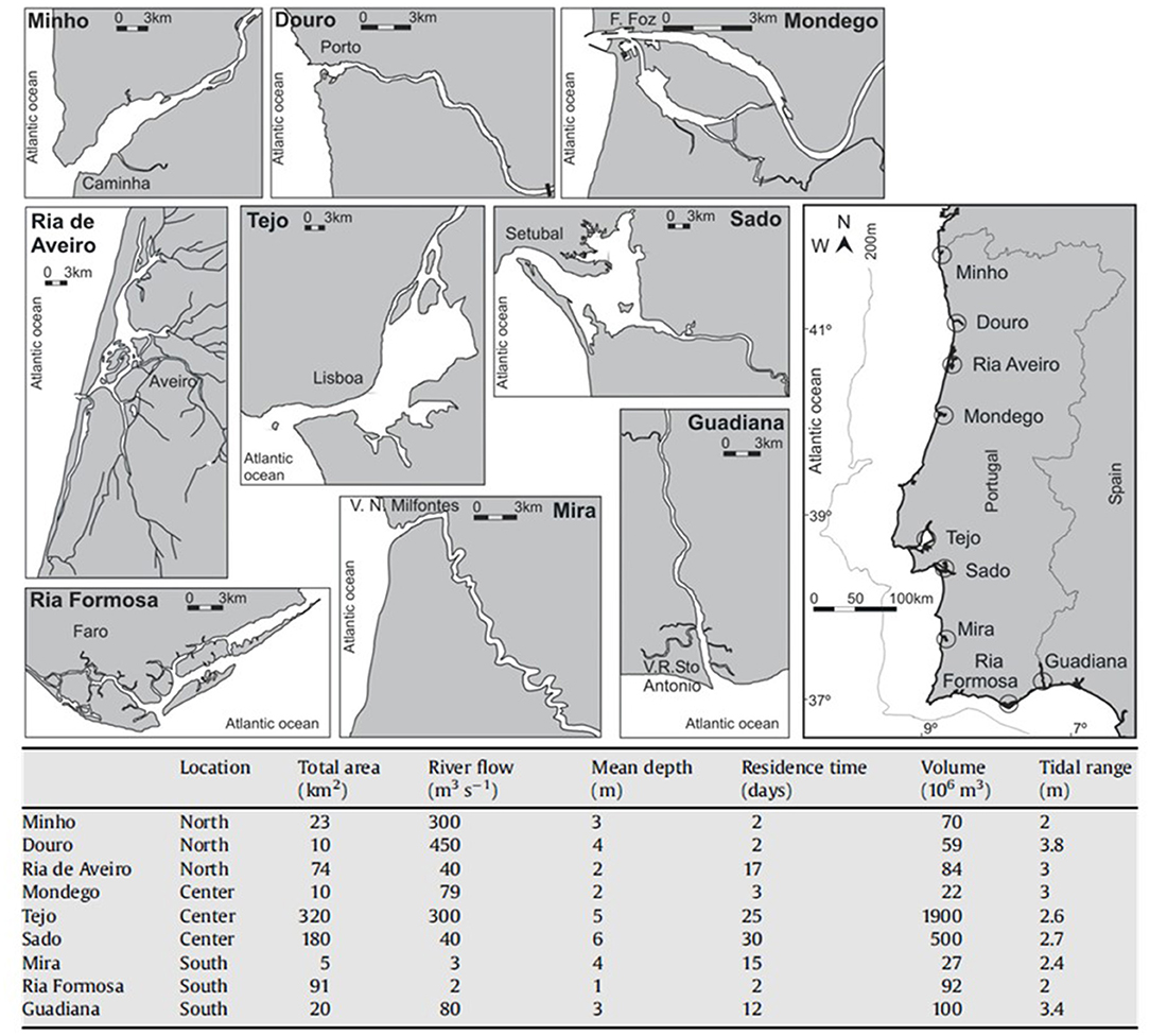
Figure 1. Estuarine systems sampled in the Portuguese coast and their main geomorphologic and hydrologic characteristics.
In the NURSERIES project, the nine referred estuaries were sampled in May and July 2006, with circa 10 hauls per site each month, with several sites across each estuary covering the main nursery grounds across the salinity gradient (number of sites per estuary depended on estuary size). In project FISHEST surveys were performed in Ria de Aveiro, Tejo, Sado, Mira and Guadiana, and sampling across renowned nursery areas was habitat-oriented focusing on salt marsh, mudflats and subtidal channels [see classification in Pihl et al. (2002)]. Fish assemblages were sampled seasonally during 2009 (January, April, July, and October), with two sites per estuary, and three hauls performed in each of the three habitats in each site. Hauls were restricted to a specific habitat type to avoid overlap between different habitats. Sampling surveys were conducted at night, using a 2 m beam trawl with a tickler chain and 5 mm mesh size in the cod end. Hauls were towed at a constant speed (0.8 m.s−1) and lasted between 8 and 10 min, whenever there was sufficient habitat area available. Salinity, conductivity (mS cm−1), water temperature (°C) and dissolved oxygen (% saturation) were measured at the beginning of each haul, using a multi-parameter probe and depth (m) was also registered. Sampled area (m2) was calculated based on the trawl opening width (2 m) and the distance travelled (m) (obtained using the coordinates registered at the beginning and at the end of each haul, with a global positioning system (GPS). Three sediment replicates were collected using a van Veen grab (0.05 m2) for the determination of mud content in the sediment (percentage of dry sediment not retained in a 0.063 mm calibrated sieve). All fish caught were identified, counted, and weighed. For full description of methods see Vasconcelos et al. (2010) for project NURSERIES and França et al. (2012) for project FISHEST.
To provide comparable attributes between systems, diversity metrics were calculated for each estuary and project: (a) species richness, which involves counting or listing species without taking into account the number of individuals, thus giving equal weight to all of them; (b) mean density, which reflects the mean number of individuals, regardless of the species, per m2; (c) mean biomass, as the mean weight of individuals, regardless of the species, per m2; and (d) the Shannon-Weiner diversity index for comparing diversity between estuaries, which takes into account two different aspects that contribute to the concept of diversity in a community, namely the number of species and their relative abundance.
Data Availability
Datasets are available in the CoastNet Geoportal, in the Historical Data section, sorted by estuary. By selecting an estuary (one or more) for further analysis, all sampling points currently uploaded in the geoportal are shown on the map, and users may freely download all the available information for the selected system(s) (for further details on how to access these data on the CoastNet Geoportal, see Supplementary Figure 1). Information on available data is presented by year, and following similar format organisation, data is also presented between years. Downloaded data, (in a zip file format), include five available documents: (1) metadata (pdf and xml files); (2) privacy policy of data publication and storage (csv file); (3) coordinates and environmental variables registered for each haul (with a unique code) (csv file); (4) species, density, and biomass for each tow (csv file); and (5) diversity indices such as species richness and Shannon-Wiener, calculated for each tow (csv file).
Analysis of Fish Assemblages
The calculated metrics varied between estuaries and although variation was also found between projects, direct comparisons on the latter were not performed with the caveat that each project had its own sampling plan, designed to answer a concrete research question (for detailed information on location of sampling sites from both projects, see Supplementary Figure 2).
Species richness obtained with data that covered the whole estuarine salinity gradient (i.e., project NURSERIES) was higher in the central and southern estuaries: from the nine sampled estuaries, the highest number of species was obtained in the following: Ria Formosa (34), Sado (32), Mondego (27), Guadiana (26), and Tejo and Mira, both with 25 fish species caught (Figure 2A). Both Tejo Estuary and Ria Formosa presented considerably higher mean densities of fish species than the other systems, with 56.1 ind. 1,000 m−2 and 27.3 ind. 1,000 m−2, respectively (Figure 2B). Mean fish biomass presented a different pattern, with the highest value recorded in the Douro Estuary (345.1 g. 1,000 m−2), which in turn had presented the lowest number of species and mean fish densities (Figure 2C). The Shannon-Wiener diversity index (H') varied between estuaries, with the highest value obtained for Ria Aveiro, which generally presented low species densities and biomass. In contrast, the Tejo Estuary, with similar number of species, and considerably higher fish densities had the lowest diversity index (H') (Figure 2D).
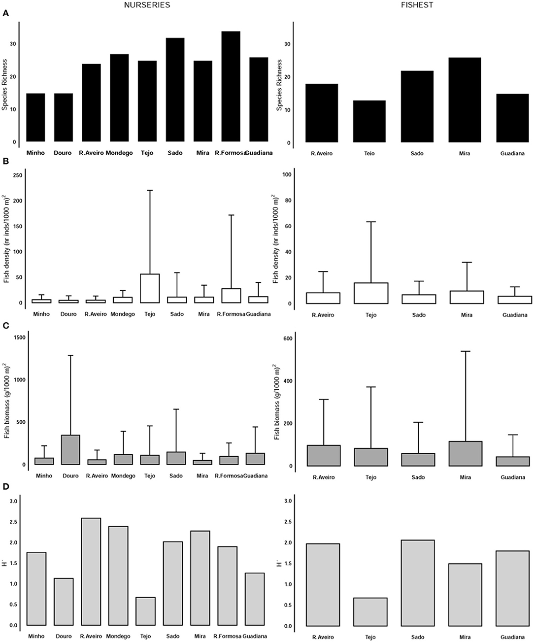
Figure 2. Variation of the Species Richness (A), Mean values of fish density (nr inds.1,000 m−2) and standard deviation (B), Mean values of fish biomass (g.1,000 m−2) and standard deviation (C) and the Shannon-Wiener diversity index (D) between estuaries, for the NURSERIES and the FISHEST projects.
In 2009, with a habitat-oriented sampling design (i.e., project FISHEST): the highest number of species was obtained in the Mira Estuary (26), while the lowest was registered in the Tejo (13) (Figure 2A). Nonetheless, the latter presented the highest mean fish densities (15.9 ind. 1,000 m−2) (Figure 2B), while highest mean biomass was obtained in the Mira Estuary (114.6 g. 1,000 m−2) (Figure 2C). The Shannon-Wiener diversity index was higher in the Sado Estuary, and the lowest diversity was registered in the Tejo Estuary (Figure 2D).
Conclusions
Overall, it is evident that these core metrics varied considerably among the estuaries. Disentangling the relationship between fish communities and estuary characteristics as well as the relevant dynamics in these ecosystems is a demanding task, given their environmental variability and complex functioning. Integrative and holistic approaches, comprising long-term data series will deepen our understanding of these processes. Nonetheless, gathering data to build such long-term series also present limitations, as each project had its own sampling plan, and was designed to answer specific research questions. Thus, caution should be taken when comparing datasets, which will depend upon the sampling methods use, and seasonal and spatial coverage, or upon proper sampling effort standardisation [see Dunn et al. (2009), Gotelli and Colwell (2011), Vasconcelos et al. (2015) for further details on this]. Although presenting intrinsic constraints, compiling historical datasets with data on fish (or other estuarine biological communities), and environmental variables allow us to leverage this data over time to develop tools to, for instance: (i) assess estuarine systems functioning and dynamics, improving knowledge on relationships between biological communities, environmental variables and ecosystems main drivers, as well as the scales at which they vary; (ii) disentangle natural variation from variation associated with climate and global changes; (iii) quantitatively hindcast trends and shifts in communities, based on taxonomic and functional structure, in response to environmental change or stressful events; (iv) evaluate changes in the nursery role of estuaries for fish species, and (v) improve accuracy on predicting the effects of several impacts on estuarine ecosystems and their services, as well as to evaluate their capability to adapt, under a global change context.
Furthermore, the possibility of having such datasets freely available at the CoastNet Geoportal for other networks and RIs, institutions and research centres, and for the cluster of sea economy will be fundamental to establish future collaborations and partnerships. The establishment of such networks and the possibility to continuously integrate more data will be fundamental towards an interdisciplinary and integrative knowledge-driven contribution to coastal management and the sustainable use of common resources. Moreover, this entails the alignment with scientific and technological national strategies with a range of national and international legislation requiring the coastal environment to be monitored (e.g., Water Framework Directive and Marine Strategy Framework Directive) and simultaneously with the 2030 Agenda for the Sustainable Development, which addresses the need for conservation and sustainable use of the ocean, seas and marine resources.
Data Availability Statement
Publicly available datasets were analyzed in this study. This data can be found here: http://geoportal.coastnet.pt.
Author Contributions
SF, JC, and HC conceived the idea and discuss the results. SF, VF, ST, RV, PR-S, AM, MR, IC, SH, and MP participated in the sampling and laboratory analysis. SF and PB analysed the data. LC prepared the data to be integrated in the CoastNet Geoportal. AB, PCa, PCh, and BQ contributed for the Research Infrastructure implementation and functioning, namely the historical data section. SF wrote the manuscript. All authors commented on and approved the final version of the manuscript, contributed to the article, and approved the submitted version.
Funding
The CoastNet Research Infrastructure (http://coastnet.pt) was funded by the Foundation for Science and Technology (FCT, I.P.) and the European Regional Development Fund (FEDER), through LISBOA2020 and ALENTEJO2020 regional operational programmes, in the framework of the National Roadmap of Research Infrastructures of strategic relevance (PINFRA/22128/2016). This publication was financed by Portuguese national funds through FCT–Fundação IP under project reference UIDB/04292/2020, and by the European Union's Horizon 2020 Research and Innovation Programme under grant agreement N810139: Project Portugal Twinning for Innovation and Excellence in Marine Science and Earth Observation–PORTWIMS. FCT, I.P. also provided support via researcher contracts to AB and SF, in the scope of the Scientific Employment Stimulus Programme (CEECIND/00095/2017 and CEECIND/02907/2017, respectively), and via researcher contracts to VF (DL57/2016/CP1479/CT0024), ST (DL57/2016/CP1479/CT0022), MP (DL57/2016/CP1479/CT0020), and SH (DL57/2016/CP1479/CT0021). RV was funded by Programa Nacional de Amostragem Biológica (EU Data Collection Framework).
Conflict of Interest
The authors declare that the research was conducted in the absence of any commercial or financial relationships that could be construed as a potential conflict of interest.
Acknowledgments
Historical data used in the present work were collected during the project NURSERIES - Importance of estuarine and coastal nursery areas for fish stocks of commercially valuable species in the Portuguese coast (FEDER 22-05-01-FDR-00037-Programa MARE, 2005–2006), supported by FEDER, and during the project FISHEST–Spatial and temporal variability of fish assemblages in different estuarine habitats: dependence, adaptive plasticity, and resilience (PTDC/MAR/64982/2006).
Supplementary Material
The Supplementary Material for this article can be found online at: https://www.frontiersin.org/articles/10.3389/fmars.2021.685294/full#supplementary-material
References
Barbier, E. B., Hacker, S. D., Kennedy, C., Koch, E. W., Stier, A. C., and Silliman, B. R. (2011). The value of estuarine and coastal ecosystem services. Ecol. Monogr. 81, 169–193. doi: 10.1890/10-1510.1
Cabral, H. N., Vasconcelos, R. P., Vinagre, C., França, S., Fonseca, V. F., Maia, A., et al. (2007). Relative importance of estuarine flatfish nurseries along the Portuguese coast. J. Sea Res. 57, 209–217. doi: 10.1016/j.seares.2006.08.007
Connor, L., Ryan, D., Feeney, R., Roche, W. K., Shephard, S., and Kelly, F. L. (2019). Biogeography and fish community structure in Irish estuaries. Reg. Stud. Mar. Sci. 32:100836. doi: 10.1016/j.rsma.2019.100836
Costanza, R., d'Arge, R., de Groot, R., Farber, S., Grasso, M., Hannon, B., et al. (1997). The value of the world's ecosystem services and natural capital. Nature 387, 253–260. doi: 10.1038/387253a0
Dunn, R. R., Agosti, D., Andersen, A. N., Arnan, X., Bruhl, C. A., Cerda, X., et al. (2009). Climatic drivers of hemispheric asymmetry in global patterns of ant species richness. Ecology Letters 12, 324–333. doi: 10.1111/j.1461-0248.2009.01291
FCT (2020). FCT-Portuguese Roadmap of Research Infrastructures. FCT. Available online at: https://www.fct.pt/media/docs/Portuguese_Roadmap_Infrastructures2020.pdf (accessed June, 2020).
França, S., and Cabral, H. N. (2016). Predicting fish species distribution in estuaries: influence of species' ecology in model accuracy. Estuar. Coast. Shelf Sci. 120, 64–74. doi: 10.1016/j.ecss.2016.06.010
França, S., Vasconcelos, R. P., Fonseca, V. F., Tanner, S. E., Reis-Santos, P., Costa, M. J., et al. (2012). Predicting fish community properties within estuaries: influence of habitat type and other environmental features. Estuar. Coast. Shelf Sci. 107, 22–31. doi: 10.1016/j.ecss.2012.04.013
Gotelli, N. J., and Colwell, R. K. (2011). “Estimating species richness,” in Biological diversity: frontiers in measurement and assessment, eds A. E. Magurran, and B. J. McGill (Oxford: Oxford University Press), 39–54.
Pihl, L., Cattrijsse, A., Codling, I., Mathieson, S., McLusky, D. S., and Roberts, C. (2002). “Habitat use by fishes in estuaries and other brackish areas,” in Fishes in Estuaries, eds M. Elliott, and K. L. Hemingway (Oxford: Blackwell Science), 656.
Reis-Santos, P., Tanner, S. E., França, S., Vasconcelos, R. P., Gillanders, B. M., and Cabral, H. N. (2015). Connectivity within estuaries: an otolith chemistry and muscle stable isotope approach. Ocean Coast. Manage. 118, 51–59. doi: 10.1016/j.ocecoaman.2015.04.012
Tanner, S. E., Reis-Santos, P., Vasconcelos, R. P., França, S., Thorrold, S. R., and Cabral, H. N. (2012). Otolith geochemistry discriminates among estuarine nursery áreas of Solea solea and S. senegalensis over time. Mar. Ecol. Prog. Ser. 452, 193–203. doi: 10.3354/meps09621
Vasconcelos, R. P., Batista, M. I., and Henriques, S. (2017). Current limitations of global conservation to protect higher vulnerability and lower resilience fish species. Sci. Rep. 7:7702. doi: 10.1038/s41598-017-06633
Vasconcelos, R. P., Henriques, S., França, S., Pasquaud, S., Cardoso, I., Laborde, M., et al. (2015). Global patterns and predictors of fish species richness in estuaries. J. Anim. Ecol. 84, 1331–1341. doi: 10.1111/1365-2656.12372
Vasconcelos, R. P., Reis-Santos, P., Costa, M. J., and Cabral, H. N. (2011). Connectivity between estuaries and marine environment: Integrating metrics to assess estuarine nursery function. Ecol. Indicat. 11, 1123–1133. doi: 10.1016/j.ecolind.2010.12.012
Keywords: CoastNet research infrastructure, historical data, estuarine fish communities, estuarine ecosystems, global changes
Citation: França S, Fonseca VF, Tanner SE, Vasconcelos RP, Reis-Santos P, Maia A, Ruano M, Cardoso I, Henriques S, Pais MP, Brandão P, Brito AC, Castellanos P, Chainho P, Quintella B, da Costa L, Costa MJ, Costa JL and Cabral HN (2021) Historical Data in the CoastNet Geoportal: Documenting Fish Assemblages in Portuguese Estuaries. Front. Mar. Sci. 8:685294. doi: 10.3389/fmars.2021.685294
Received: 24 March 2021; Accepted: 27 May 2021;
Published: 06 July 2021.
Edited by:
Angel Pérez-Ruzafa, University of Murcia, SpainReviewed by:
Alan Whitfield, South African Institute for Aquatic Biodiversity, South AfricaFrancisco José Oliva-Paterna, University of Murcia, Spain
Copyright © 2021 França, Fonseca, Tanner, Vasconcelos, Reis-Santos, Maia, Ruano, Cardoso, Henriques, Pais, Brandão, Brito, Castellanos, Chainho, Quintella, da Costa, Costa, Costa and Cabral. This is an open-access article distributed under the terms of the Creative Commons Attribution License (CC BY). The use, distribution or reproduction in other forums is permitted, provided the original author(s) and the copyright owner(s) are credited and that the original publication in this journal is cited, in accordance with accepted academic practice. No use, distribution or reproduction is permitted which does not comply with these terms.
*Correspondence: Susana França, c29mcmFuY2FAZmMudWwucHQ=