 Astrid J. Hsu1*
 Sara Pruckner2
 Erin V. Satterthwaite3,4,5
 Lauren V. Weatherdon2
 Keiran Hadley1
 Elizabeth Thanh Tam Nguyen1
- 1Scripps Institution of Oceanography, La Jolla, CA, United States
- 2United Nations Environment Programme World Conservation Monitoring Centre, Cambridge, United Kingdom
- 3National Center for Ecological Analysis and Synthesis, University of California, Santa Barbara, Santa Barbara, CA, United States
- 4Future Earth, School of Global Environmental Sustainability, Colorado State University, Fort Collins, CO, United States
- 5California Sea Grant, Scripps Institution of Oceanography, University of California, San Diego, La Jolla, CA, United States
As the use of aerial tools such as unmanned aerial vehicles (UAVs) for mangrove monitoring gains in popularity, understanding who leads this research and where is critical for expanding efficient monitoring methods and achieving international commitments to sustainable development, technology transfer and reduced inequality. Between 2000 and 2019, mangrove research using aerial tools was largely conducted in and led by institutions in higher income countries, despite High-income countries accounting for only 9% of global mangrove coverage. Of studies where the country of the lead institution differed from that of the study site, only 38% of the studies included local co-authors. These results echo historical patterns of research conducted by researchers from higher income countries on biodiversity concentrated in lower income countries, frequently with limited involvement of local scientists—known as “helicopter research.” The disconnect between where mangroves are located and where aerial research is conducted may result from barriers such as government restrictions, limited financial and technical resources, language barriers hindering UAV deployment, or hampered findability of local research. Our findings suggest that expertise for aerial surveys currently lies in “High-income, Annex II” and “Upper-middle-income, Non-Annex” countries, and both groups could invest time and resources in building local, long-term technological capacity in Upper-middle, Lower-middle and Low-income countries. We identify strategic partnerships to expand aerial tools for mangrove research that also address commitments under the United Nations Framework Convention on Climate Change and potential international collaborations under the framework proposed by the UN Decade of Ocean Science for Sustainable Development.
Introduction
As the global climate rapidly changes, mangroves have emerged as critical players for adaptation and mitigation, protecting coastlines against storms, and erosion and sequestering atmospheric carbon (Alongi, 2008; Donato et al., 2011). Yet, mangroves have historically high rates of deforestation, and land-use changes continue to threaten the habitat’s future (Friess et al., 2019). Mangroves are considered an essential ocean variable to be monitored by the Global Ocean Observing System (GOOS) and are listed as an ecosystem indicator by the Sustainable Development Goals (SDGs) (Malone, 2003; CBD High-Level Panel, 2014; Friess et al., 2019). Long-term observations are necessary to support implementation of country-specific Nationally Determined Contributions (NDCs) of the Paris Agreement and fulfilment of other commitments that foster sustainable mangrove management (Bax et al., 2018). Monitoring mangroves provides baseline data foundational to guiding spatial planning decisions and financial investments that mitigate pressures from climate change, coastal development, pollution, agriculture and other land- and sea-use changes (Schmitt and Duke, 2015; Pham et al., 2019).
Least Developed Countries and Small Island Developing States often lack the resources and technology to carry out sustained observations, which tend to be financially costly and require long-term investment. This is especially true of in situ observations, which provide extremely detailed diversity and extent information crucial to local management. Establishing sustained monitoring requires building capacity and transferring technology (and associated technological skills) with these communities (Bax et al., 2018). Lower income countries are especially vulnerable to “helicopter research,” the process of researchers from high-income countries conducting field research in lower income countries without local researchers involved in the study or benefiting from the results; a trend spotted in soil science, biology, and genomics (Minasny et al., 2020). Thus, capacity development and technology transfer have been highlighted as priorities by the World Ocean Assessment, UN Convention on the Law of the Sea, Intergovernmental Oceanographic Commission, and the UN Decade of Ocean Science for Sustainable Development (UN Ocean Decade) (Inniss et al., 2016; Bax et al., 2018).
To better observe mangrove ecosystems, researchers have increasingly used remote sensing technologies (Wang et al., 2019). While satellite imagery has been leveraged to provide global estimates of mangrove extent (Bunting et al., 2018), the use of aerial tools is particularly well suited for in situ coverage. Aerial tools such as manned aircrafts and unmanned aerial vehicles (UAVs) have captured high-resolution data on many mangrove attributes, including forest extent, species biodiversity, vertical forest structure, and carbon flux (Zulueta et al., 2013; Feliciano et al., 2017; Ruwaimana et al., 2018). Due to their cost-effectiveness, UAVs are revolutionizing conservation management by providing high spatio-temporal observations, especially in small, inaccessible, or highly sensitive areas (Jiménez López and Mulero-Pázmány, 2019). Although the cost is variable, employing UAVs is often cheaper and more efficient than using manned aircrafts or conducting on-the-ground mangrove surveys (Otero et al., 2018; Ruwaimana et al., 2018; Navarro et al., 2020).
This study explores the global distribution of studies using aerial imaging to monitor mangrove forests worldwide in relation to country income and United Nations Framework Convention on Climate Change (UNFCCC) designations. We investigate how equitable access to aerial tools can directly contribute to the societal outcomes of the: (1) UNFCCC, for sustainable partnerships between Developed Countries and Developing/Least Developed Countries (UNFCCC, 1992) and; (2) UN Ocean Decade, for the integration of remote and in situ observations to reduce observational costs (A Predicted Ocean) and increase data accessibility to stakeholders (A Transparent and Accessible Ocean) (Ryabinin et al., 2019). Under these frameworks, we detail challenges and recommendations to guide capacity building and technology transfer of aerial tools for mangrove conservation in lower income countries with greater mangrove coverage.
Current Global Distribution of Aerial Research
We investigated differences in the distribution between mangroves and aerial research alongside each country’s socioeconomic status and UNFCCC commitment. We referenced the 2016 Global Mangrove Watch extent layer to map the mangrove distribution across countries, cross-referencing these countries with: (i) 2019 income group classifications from the World Bank; and (ii) Annex I, Annex II and Non-Annex designations from the UNFCCC (Bunting et al., 2018; UNFCCC, 2018; World Bank Data, 2019; UNEP-WCMC, 2020). The term “countries” is used interchangeably with economies as defined by the World Bank, and “does not imply political independence but refers to any territory for which authorities report separate social or economic statistics.”
To describe where aerial research is occurring and who leads the effort, we performed a manual literature search in English for each country with mangrove coverage on Google Scholar and Web of Science using a formula of key terms: “(country name) + mangroves + (aerial tool).” In place of “aerial tool,” the search was repeated for “aerial photography,” “drone,” “UAV,” “unmanned aerial system (UAS),” and “remotely piloted aircraft (RPA).” Search results were reviewed for relevant scientific publications, conference documents, and theses. After three search pages of no additional relevant literature, the search was determined to be exhausted. From each article, we collected where the study was conducted, who led the study, and the country of the lead author’s institution. We examined the institutions of all co-authors and noted authors with institutions local to the study site. From our literature review, we analyzed a total of 72 aerial in situ studies conducted in 24 countries led by researchers from 19 countries. The majority of the studies used small UAVs to capture imagery (60%), followed by small airplanes (42%) and kites (1%).
We identified three main discrepancies:
1. Gap between mangrove coverage and study site based on income
Based on World Bank income levels, Figure 1A shows that global mangrove coverage differs from the countries of study sites. High-income countries published at four times the rate of the amount of coverage they have (mangrove coverage of 11%, but comprise 43% of studies) and Upper-middle-income countries published at 1.5 times their coverage (32 and 44%). Lower-middle-income countries published at 0.25 their coverage (46 and 10%) and Low-income countries published at 0.1 times their coverage (10 and 1%). Thus, mangrove occurrence was greater in lower socioeconomic countries, while mangrove aerial research was conducted in higher income countries.
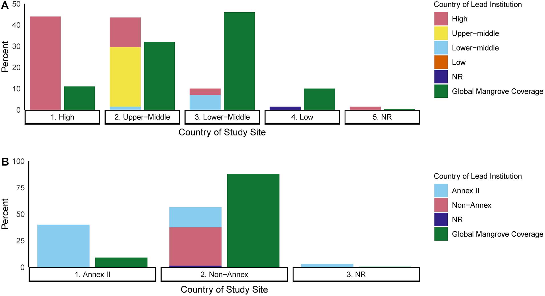
Figure 1. (A) Percentage of studies conducted within each country by income level designation from the World Bank Data (2019). The income designation by the World Bank is not recorded (NR) for the following countries and territories: Mayotte, Anguilla, Guadalupe, Bonaire, Sint-Eustatius, Saba, and Martinique. In green, the percentage global mangrove coverage from Bunting et al., 2018. (B) The distribution of studies based on the UNFCCC designations of the country where the study occurred and the country that led the study (lead institution). Percentages are shown in relation to the all studies per UNFCCC party (n = 72). Countries or territories that are not listed as a party to the UNFCCC (NR) are French Guiana and Turks and Caicos Island. Percentage of global mangrove coverage by UNFCCC party is also shown.
2. Gap between mangrove coverage and lead country based on Annex designations
Annex II countries led 61% of the studies but accounted for just 9% of mangrove coverage, while Non-Annex countries led just 35% of the studies but represented 88% of mangrove coverage. Study sites were split between Annex II (40% of studies) and Non-Annex countries (56% of studies) (Figure 1B). Thus, mangrove occurrence was greater in Non-Annex countries, but research was largely led by Annex II countries.
3. Gap in capacity building
In 21 of the 72 studies (29%), the research site was in a different country than that of the lead institution (Figure 2A), and eight of these 21 studies (38%) included a co-author from a local institution. Of these eight studies, seven had lead institutions in High-income/Annex II countries and study sites in two other High-income/Annex II countries, four Upper-middle/Non-Annex countries, and one Lower-middle/Non-Annex country. The last study of the eight had an Upper-middle/Non-Annex country leading a study in a country without a World Bank income.
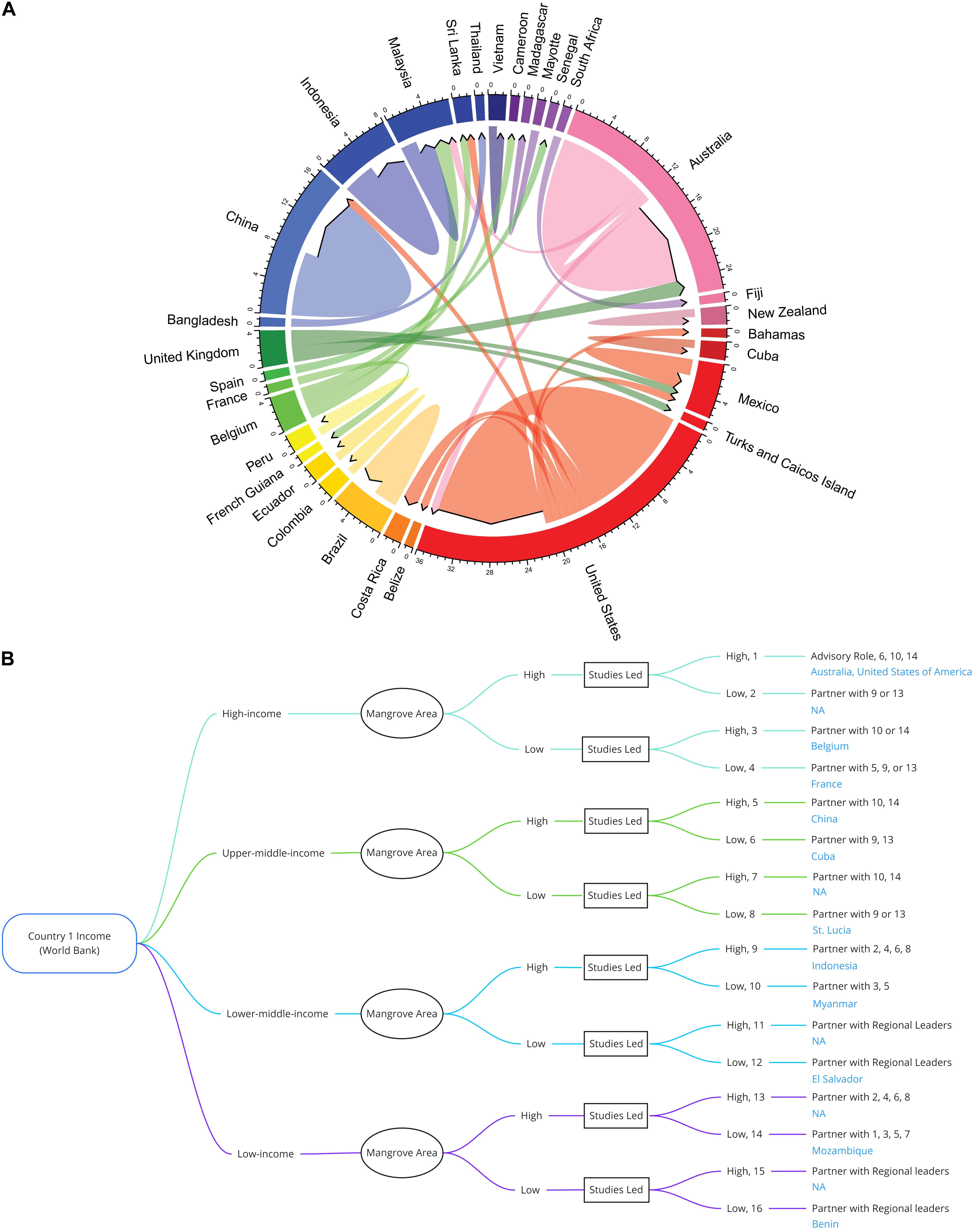
Figure 2. (A) Summary of countries with researchers leading 72 aerial studies, and where those studies are conducted. Continents are represented by the following shades: Asia—blue; Africa—purple; Oceania—pink; North America—red; Central America—yellow; South America—orange; Europe—green. Color of the chord represents the country that is leading the study. Chords leaving the country denote the number of studies led by that country, while black-tipped chords pointing to a country denotes the number of studies that are conducted within that country. (B) Decision-tree of suggested partnerships regarding mangrove monitoring using aerial tools. Thresholds of each step is determined as follows: Country income: Levels determined by World Bank; Mangrove Area: High is top 28 countries in global mangrove coverage, which covers up to 90% of the world’s mangroves, Low is any country outside of this top 15; Studies led: High is four and above (average of the data set), Low is three and below. Example countries are in blue. NA denotes that no example country was found.
The gaps presented mirror the broader trend of a mismatch among biodiversity research and areas of high biodiversity. Higher biodiversity tends to be in countries with developing economies, yet biological research tends to be conducted in or by higher income countries (Fazey et al., 2005). The gaps also suggest trends of “helicopter research, and highlight a need to broaden aerial research endeavors and engage local communities in scientific leadership through capacity building and technology transfer.
Current Challenges and Recommendations for UAVs
As UAVs are still an emerging technology, trends of helicopter research could be avoided. The 72 studies identified in this paper are just a sliver of the entirety of mangrove research; however, this problem has been identified across many disciplines and tools (Parsons et al., 2017; Minasny et al., 2020). By focusing on technology transfer, scientific equity, and collaborative processes across regions, the benefits of aerial tools could be harnessed globally and lead to greater collective knowledge generation.
Scaling UAV use for mangroves aligns with the UN Ocean Decade and could be achieved by filling gaps in data generation and resource availability early in the process and following FAIR – findable, accessible, interoperable and reusable – data principles (Wilkinson et al., 2016). This study’s results suggest a disparity between countries where mangroves occur and countries currently conducting aerial surveys. This can be explained by two reasons: the data have not been generated and/or were not found in this review. Both are likely true and are addressed below.
Data Generation
Government Restrictions
A lack of aerial data generation in some countries may be associated with restrictive government regulations of the scientific use of UAVs. For example, countries such as Cuba and India have bans against the commercial and scientific use of UAVs while others, including Chile and Colombia, place “effective bans” that technically allow UAV use but with strict requirements and licenses (Jones, 2017; Stöcker et al., 2017). Comparatively, several European organizations (i.e., European Union Aviation Safety Agency) focused on integrating regulated UAV use, allowing greater accessibility for commercial or scientific use (Stöcker et al., 2017). Countries like China, France, and the United States have experimental—and thus more flexible—UAV regulations as well as corporations (DJI, Parrot, Skydio) that manufacture UAVs. To enable emerging technologies to be used and established in low-income countries, regulations should be flexible to permit scientific UAV use while considering the sensitivity of local habitats.
Limited Financial and Technical Resources
Where government restrictions do not inadvertently restrict data generation, limited resources for mangrove research can be another common reason. As shown by several meta-analyses, biodiversity research tends to happen more in higher-income as opposed to lower-income countries, often due to lower research capacities in lower-income countries (Fazey et al., 2005).
To overcome financial difficulties, international collaboration for science and accessible funding sources for low-income country-led studies are key. The UNFCCC provides a framework to facilitate international capacity building and technology transfer in relation to climate change, since Annex II countries have committed financial support and knowledge transfer to developing countries (UNFCCC, 1992). Studying mangroves through aerial research is covered by this, as UAVs are well-suited to estimate local mangrove extent and carbon stocks relevant to NDCs (Ruwaimana et al., 2018). Thus, this study’s results can serve as one metric for Annex II countries’ mandatory reports on climate finance and technology support, and guide developing countries in their requests for technology and capacity building needs (Ellis and Moarif, 2015).
Outside of Annex II obligations, certain countries may find themselves in the position to lead. Upper-middle-income, Non-Annex countries such as China, Brazil, and Mexico comprised 28% of the studies and 32% of mangrove coverage. These Upper-Income Non-Annex countries may find themselves well-equipped to not only study their local mangroves, but to also act as regional leaders and extend their knowledge to neighboring countries. As such, the expertise for aerial surveys currently lies in High-income, Annex II countries and in Upper-middle-income, Non-Annex countries. These categories of countries can invest time and resources in the transfer of technology and skills to other countries, especially Low-income countries (10% of mangrove coverage) which have only 1% of mangrove studies (Figure 1).
Furthermore, international journals could allow researchers and students in low-income countries access to articles free of charge, to promote the development of research capacity. This approach has already been implemented by organizations such as The Royal Society through their Research4Life initiative (Hamilton and Hurst, 2018). Other journals could consider implementing similar initiatives.
Software Language
Language barriers exist during the data acquisition process. With UAVs developed by Western and Chinese companies, languages are often limited to English, Chinese, and a handful of other languages. For example, DJI Ground Station Pro, a mission-planning companion app to DJI UAVs, is currently available in only Chinese, Japanese, and English (DJI, 2020). Likewise, Pix4Dcapture is available in English, German, Japanese, Spanish, Chinese, and Portuguese (Pix4D, 2020). The incompatibility in languages between the software and the end-users can be a challenge for capacity building of aerial technology. Private-public relationships and increasing demand for Unmanned aerial vehicle products could encourage broadening of available languages for associated software.
Data Findability and Accessibility
Our findings may also indicate that existing aerial mangrove observations and research conducted in Non-Annex and lower income countries are often not readily available online or are published in national journals or documented in other languages that hinder their integration into global baseline datasets, which are predominantly curated using the English language.
An additional challenge relates to making data accessible, which is a multi-faceted problem in itself. Often, data are not under a clearly defined data license, and “open access” itself is often insufficiently defined and communicated. Creative Commons licenses can help clarify different levels of access, and more organizations are promoting and implementing open data policies. Specific data contributor agreements often need to be put in place to use small, individual datasets together, which can be time-consuming and costly to implement.
Discussion
To address these barriers, we recommend leveraging current frameworks for best practices and establishing new partnerships to facilitate knowledge sharing and technology transfer.
Leveraging Current Frameworks for Best Practices and Shared Methodologies
To support building capacity and the technology transfer of aerial tools for mangrove conservation, sharing the methodologies, metadata, and current data is crucial. Knowledge sharing can be done through the Global Mangrove Alliance (GMA), an alliance of global mangrove actors and stakeholders. The GMA’s extensive network encompasses a wide range of users, and their Mangrove Knowledge Hub acts as a clearinghouse for accessible mangrove-related information. Adding resources for UAVs to the Mangrove Knowledge Hub can help increase the findability and accessibility of methodologies, and standardize methodologies. Further, through the GMA, encouraging members and non-members to deposit gray literature into the resources library can help elevate these studies, which can further increase the findability of gray literature—especially non-English literature. Findability of gray literature is further supported by platforms such as ePrints in Library and Information Science (E-LIS) which focuses on open science in multiple countries and over 27 languages (De Robbio et al., 2020). Effort on behalf of government and academic institutions to promote FAIR principles would also greatly reduce the “grayness” of literature and promote findability without the need to build new facilities or infrastructure (Schöpfel and Rasuli, 2018).
Partnerships
The low percentage of studies including local co-authors when lead institutions are foreign suggests that aerial research of mangroves may fall prey to helicopter research, and that robust partnerships and capacity building efforts are needed. To further support capacity building and technology transfer under the UNFCCC and UN Ocean Decade, developing effective partnerships to shepherd UAV training is needed. Some countries, such as Indonesia, maintain a legal mandate in which foreign researchers must involve local Indonesian scientists as equal collaborators (Rochmyaningsih, 2019). We identified the following potential partnerships to transfer use of aerial tools for mangrove conservation (Figure 2B):
• Upper-middle-income or High-income, Annex II countries could partner with Lower-middle or Low-income countries with high mangrove coverage to support training.
• Higher income countries that lead a low number of studies and have low mangrove coverage could offer investments for automated image analysis, such as improving internet access and supporting remote cloud processing (Miloslavich et al., 2018).
• Lower income countries that lead a low number of studies and have low mangrove coverage could train with respective regional leaders.
Even with these partnerships, effective capacity building and training workshops must be carefully conducted. As mentioned, limited language availability of associated software remains an obstacle, and demonstrates the important role of private institutions in expanding their multilingual support (Beekhuyzen et al., 2005). Further, key considerations include determining the appropriate criteria for trainee candidates, the local stakeholders and scientists involved, teaching styles, local infrastructure limitations, and financial considerations (Miloslavich et al., 2018). A high degree of in-person support is often vital to successful capacity development, especially to avoid ‘brain drain’ of young locals to high-income countries and to foster technical resilience of local researchers. These partnerships can further promote data repatriation and findability, ensuring that these data are held by in-country institutions or hosted on national data platforms to encourage accessibility and use for local decision-making (e.g., Dias et al., 2017; Asase and Schwinger, 2018). The GOOS and UNFCCC provide international guidance to facilitate capacity development and technology transfer (Bax et al., 2018).
Implications
Between 1996–2010, the world lost 12% of its mangroves, with 50% of this loss occurring in Southeast Asia (Thomas et al., 2017). This region not only maintains 34% of the world’s mangroves, but the income designations of these countries are largely Low, Lower-middle and Upper-middle-income. There is often an economic impetus to deforest mangroves: in Southeast Asia, mangroves have mostly been replaced by aquaculture, rice fields, and oil palm plantations, which are exportable commodities often held by large corporations (Richards and Friess, 2016), whereas the ecosystem services provided by healthy mangroves are more equitably accessible (Armitage, 2002). Equipping these countries with the tools needed to effectively monitor their mangroves can therefore be a double-edged sword. Changing the political and economic narrative to include the benefits and alternative livelihoods that local communities and the rural poor gain from mangroves is essential (Armitage, 2002).
Implementing and monitoring sustainable mangrove management is crucial to achieving international and regional commitments related to climate and sustainability. With just 45 NDCs including mangroves and global efforts failing to achieve the Aichi Biodiversity Targets, transferring UAVs and associated technology can boost countries’ capacity to integrate mangrove-specific targets in their NDCs and contribute to tracking relevant indicators within the post-2020 global biodiversity framework (Gallo et al., 2017; Secretariat of the Convention on Biological Diversity, 2020).
Mangrove ecosystem services, particularly coastal protection, are especially beneficial to developing countries (Barbier, 2016). Thus, capacity building of aerial tools for effective mangrove management can enhance resilience in the most vulnerable communities. In situ aerial studies further provide greater local context for on-the-ground issues while strengthening global datasets, but integration of aerial tools such as UAVs into community-based monitoring efforts requires external assistance and financing to build local capacity (Worthington et al., 2020). By sharing methods and data, promoting effective partnerships and FAIR data standards, and implementing mindful training, equitable access to aerial tools for mangroves can be achieved.
Data Availability Statement
The raw data supporting the conclusions of this article will be made available by the authors, without undue reservation.
Author Contributions
All authors listed have made a substantial, direct and intellectual contribution to the work, and approved it for publication.
Funding
This work is funded by the Pew Charitable Trusts (award number 31,686, AH), Paul M. Angell Family Foundation, and The Baum Foundation (AH), PEGASuS 2: Ocean Sustainability Program funded in part by the Gordon and Betty Moore Foundation’s Science Program and the NOMIS Foundation (ES). This work was partially funded by UNEP-WCMC’s Proteus Partnership (SP and LW). The funders were not involved in any aspect of this work.
Conflict of Interest
The authors declare that the research was conducted in the absence of any commercial or financial relationships that could be construed as a potential conflict of interest.
Acknowledgments
We would like to thank reviewers for their feedback on this manuscript. This publication was possible thanks to the Paul M. Angell Family Foundation. AH was supported in part by the Pew Charitable Trusts and the Baum Foundation. ES was supported by the PEGASuS 2: Ocean Sustainability Program funded in part by the Gordon and Betty Moore Foundation’s Science Program and the NOMIS Foundation.
References
Alongi, D. M. (2008). Mangrove forests: resilience, protection from tsunamis, and responses to global climate change. Estuar. Coast. Shelf Sci. 76, 1–13. doi: 10.1016/j.ecss.2007.08.024
Armitage, D. (2002). Socio-institutional dynamics and the political ecology of mangrove forest conservation in Central Sulawesi, Indonesia. Glob. Environ. Change 12, 203–217. doi: 10.1016/S0959-3780(02)00023-7
Asase, A., and Schwinger, G. O. (2018). Assessment of biodiversity data holdings and user data needs for Ghana. Biodivers. Inform. 13, 27–37. doi: 10.17161/bi.v13i0.7108
Barbier, E. B. (2016). The protective service of mangrove ecosystems: a review of valuation methods. Mar. Pollut. Bull. 109, 676–681. doi: 10.1016/j.marpolbul.2016.01.033
Bax, N. J., Appeltans, W., Brainard, R., Duffy, J. E., Dunstan, P., Hanich, Q., et al. (2018). Linking capacity development to GOOS monitoring networks to achieve sustained ocean observation. Front. Mar. Sci. 5:346. doi: 10.3389/fmars.2018.00346
Beekhuyzen, J., von Hellens, L., and Siedle, M. (2005). “Cultural barriers in the adoption of emerging technologies,” in Proceedings of the HCI International 2005 (Brisbane, Qld: Griffith University).
Bunting, P., Rosenqvist, A., Lucas, R. M., Rebelo, L.-M., Hilarides, L., Thomas, N., et al. (2018). The global mangrove watch—a new 2010 global baseline of mangrove extent. Remote Sens. 10:1669. doi: 10.3390/rs10101669
CBD High-Level Panel (2014). Resourcing the Aichi Biodiversity Targets: An Assessment of Benefits, Investments and Resource Needs for Implementing the Strategic Plan for Biodiversity 2011-2020. Second Report of the High-Level Panel on Global Assessment of Resources for Implementing the Strategic Plan for Biodiversity 2011-2020. Montreal: UNEP.
De Robbio, A., Subirats-Coll, I., Cosco, A., Vidal-Cabo, C., and Peset, F. (2020). E-LIS between old and new forms of grey literature encompasses new forms of relationship among librarians in the different country. TGJ 16, 105–112.
Dias, D., Baringo Fonseca, C., Correa, L., Soto, N., Portela, A., Juarez, K., et al. (2017). Repatriation data: more than two million species occurrence records added to the Brazilian Biodiversity Information Facility Repository (SiBBr). Biodivers. Data J. 5:e12012. doi: 10.3897/BDJ.5.e12012
DJI (2020). DJI GS Pro (version 2.0.14) [iOS]. Available onlinen at: https://apps.apple.com/app/dji-gs-pro/id1183717144 (accessed November, 2020).
Donato, D. C., Kauffman, J. B., Murdiyarso, D., Kurnianto, S., Stidham, M., and Kanninen, M. (2011). Mangroves among the most carbon-rich forests in the tropics. Nat. Geosci. 4, 293–297. doi: 10.1038/ngeo1123
Ellis, J., and Moarif, S. (2015). Identifying and Addressing Gaps in the UNFCCC Reporting Framework. Paris: OECD.
Fazey, I., Fischer, J., and Lindenmayer, D. B. (2005). Who does all the research in conservation biology? Biodivers. Conserv. 14, 917–934. doi: 10.1007/s10531-004-7849-9
Feliciano, E. A., Wdowinski, S., Potts, M. D., Lee, S.-K., and Fatoyinbo, T. E. (2017). Estimating mangrove canopy height and above-ground biomass in the everglades national park with airborne LiDAR and TanDEM-X data. Remote Sens. 9:702. doi: 10.3390/rs9070702
Friess, D. A., Aung, T. T., Huxham, M., Lovelock, C., Mukherjee, N., and Sasmito, S. (2019). “SDG 14: life below water – impacts on mangroves,” in Sustainable Development Goals: Their Impacts on Forests and People, eds C. J. Pierce Colfer, G. Winkel, G. Galloway, P. Pacheco, P. Katila, and W. de Jong (Cambridge: Cambridge University Press), 445–481.
Gallo, N. D., Victor, D. G., and Levin, L. A. (2017). Ocean commitments under the Paris Agreement. Nat. Clim. Change 7, 833–838. doi: 10.1038/nclimate3422
Hamilton, S., and Hurst, P. (2018). Journals Access and Article Processing Charge Waiver for Lower-Income Countries. Available online at: https://royalsociety.org/blog/2018/01/journals-access-and-article-waiver/ (accessed October, 2020).
Inniss, L., Simcock, A., Yoanes Ajawin, A., Alcala, A. C., Bernal, P., Calumpong, H. P., et al. (2016). The First Global Integrated Marine Assessment: World Ocean Assessment I. New York, NY: United Nations.
Jiménez López, J., and Mulero-Pázmány, M. (2019). Drones for conservation in protected areas: present and future. Drones 3:10. doi: 10.3390/drones3010010
Jones, T. (2017). International Commercial Drone Regulation and Drone Delivery Services. Santa Monica, CA: RAND Corporation.
Malone, T. C. (2003). The coastal module of the Global Ocean Observing System (GOOS): an assessment of current capabilities to detect change. Mar. Policy 27, 295–302. doi: 10.1016/S0308-597X(03)00043-5
Miloslavich, P., Seeyave, S., Muller-Karger, F., Bax, N., Ali, E., Delgado, C., et al. (2018). Challenges for global ocean observation: the need for increased human capacity. J. Oper. Oceanogr. 12, S137–S156. doi: 10.1080/1755876X.2018.1526463
Minasny, B., Fiantis, D., Mulyanto, B., Sulaeman, Y., and Widyatmanti, W. (2020). Global soil science research collaboration in the 21st century: time to end helicopter research. Geoderma 373:114299. doi: 10.1016/j.geoderma.2020.114299
Navarro, A., Young, M., Allan, B., Carnell, P., Macreadie, P., and Ierodiaconou, D. (2020). The application of Unmanned Aerial Vehicles (UAVs) to estimate above-ground biomass of mangrove ecosystems. Remote Sens. Environ. 242:111747. doi: 10.1016/j.rse.2020.111747
Otero, V., Van De Kerchove, R., Satyanarayana, B., Martínez-Espinosa, C., Fisol, M. A. B., Ibrahim, M. R. B., et al. (2018). Managing mangrove forests from the sky: forest inventory using field data and Unmanned Aerial Vehicle (UAV) imagery in the Matang Mangrove Forest Reserve, peninsular Malaysia. For. Ecol. Manag. 411, 35–45. doi: 10.1016/j.foreco.2017.12.049
Parsons, E. C. M., MacPherson, R., and Villagomez, A. (2017). Marine “Conservation”: you keep using that word but I don’t think it means what you think it means. Front. Mar. Sci. 4:200. doi: 10.3389/fmars.2017.00299
Pham, T. D., Yokoya, N., Bui, D. T., Yoshino, K., and Friess, D. A. (2019). Remote sensing approaches for monitoring mangrove species, structure, and biomass: opportunities and challenges. Remote Sens. 11:230. doi: 10.3390/rs11030230
Pix4D (2020). Pix4Dcapture (version 4.12.1) [iOS]. Available online at: https://apps.apple.com/us/app/pix4dcapture/id953486050?ls=1 (accessed November, 2020).
Richards, D. R., and Friess, D. A. (2016). Rates and drivers of mangrove deforestation in Southeast Asia, 2000–2012. Proc. Natl. Acad. Sci. U. S. A. 113, 344–349. doi: 10.1073/pnas.1510272113
Rochmyaningsih, D. (2019). Indonesia’s Strict New Biopiracy Rules Could Stifle International Research. Available online at: https://www.sciencemag.org/news/2019/07/indonesia-s-strict-new-biopiracy-rules-could-stifle-international-research (accessed October, 2020)
Ruwaimana, M., Satyanarayana, B., Otero, V., Muslim, A. M., Syafiq, A. M., Ibrahim, S., et al. (2018). The advantages of using drones over space-borne imagery in the mapping of mangrove forests. PLoS One 13:e0200288. doi: 10.1371/journal.pone.0200288
Ryabinin, V., Barbière, J., Haugan, P., Kullenberg, G., Smith, N., McLean, C., et al. (2019). The UN decade of ocean science for sustainable development. Front. Mar. Sci. 6:470. doi: 10.3389/fmars.2019.00470
Schmitt, K., and Duke, N. C. (2015). “Mangrove management, assessment and monitoring,” in Tropical Forestry Handbook, eds M. Köhl and L. Pancel (Berlin: Springer), 1–29.
Schöpfel, J., and Rasuli, B. (2018). Are electronic theses and dissertations (still) grey literature in the digital age? A FAIR debate. Electron. Libr. 36, 208–219. doi: 10.1108/EL-02-2017-0039
Secretariat of the Convention on Biological Diversity (2020). Global Biodiversity Outlook 5. Montreal: World Trade Centre.
Stöcker, C., Bennett, R., Nex, F., Gerke, M., and Zevenbergen, J. (2017). Review of the current state of UAV regulations. Remote Sens. 9:459. doi: 10.3390/rs9050459
Thomas, N., Lucas, R., Bunting, P., Hardy, A., Rosenqvist, A., and Simard, M. (2017). Distribution and drivers of global mangrove forest change, 1996–2010. PLoS One 12:e0179302. doi: 10.1371/journal.pone.0179302
UNEP-WCMC (2020). Ocean Data Viewer. Available online at: http://data.unep-wcmc.org (accessed October, 2020).
UNFCCC (1992). United Nations Framework Convention on Climate Change. Available online at: https://unfccc.int/sites/default/files/convention_text_with_annexes_english_for_posting.pdf (accessed October, 2020).
UNFCCC (2018). United Nations Framework Convention on Climate Change Process Parties. Available online at: https://unfccc.int/process/parties-non-party-stakeholders/parties-convention-and-observer-states (accessed October, 2020).
Wang, L., Jia, M., Yin, D., and Tian, J. (2019). A review of remote sensing for mangrove forests: 1956–2018. Remote Sens. Environ. 231:111223. doi: 10.1016/j.rse.2019.111223
Wilkinson, M. D., Dumontier, M., Aalbersberg, I. J. J., Appleton, G., Axton, M., Baak, A., et al. (2016). The FAIR guiding principles for scientific data management and stewardship. Sci. Data 3:160018. doi: 10.1038/sdata.2016.18
World Bank Data (2019). Team New Country Classifications by Income Level: 2019-2020. Available online at: https://blogs.worldbank.org/opendata/new-country-classifications-income-level-2019-2020 (accessed October, 2020).
Worthington, T. A., Andradi-Brown, D. A., Bhargava, R., Buelow, C., Bunting, P., Duncan, C., et al. (2020). Harnessing big data to support the conservation and rehabilitation of mangrove forests globally. One Earth 2, 429–443. doi: 10.1016/j.oneear.2020.04.018
Zulueta, R. C., Oechel, W. C., Verfaillie, J. G., Hastings, S. J., Gioli, B., Lawrence, W. T., et al. (2013). Aircraft regional-scale flux measurements over complex landscapes of mangroves, desert, and marine ecosystems of Magdalena Bay, Mexico. J. Atmos. Oceanic Technol. 30, 1266–1294. doi: 10.1175/JTECH-D-12-00022.1
Keywords: UAVs, ocean observing, capacity development, technology transfer, country income
Citation: Hsu AJ, Pruckner S, Satterthwaite EV, Weatherdon LV, Hadley K and Nguyen ETT (2021) Challenges and Recommendations for Equitable Use of Aerial Tools for Mangrove Research. Front. Mar. Sci. 8:643784. doi: 10.3389/fmars.2021.643784
Received: 18 December 2020; Accepted: 04 March 2021;
Published: 09 April 2021.
Edited by:
Ana M. M. Sequeira, University of Western Australia, AustraliaReviewed by:
Antoine De Ramon N’Yeurt, University of the South Pacific, FijiFernanda Adame, Griffith University, Australia
Copyright © 2021 Hsu, Pruckner, Satterthwaite, Weatherdon, Hadley and Nguyen. This is an open-access article distributed under the terms of the Creative Commons Attribution License (CC BY). The use, distribution or reproduction in other forums is permitted, provided the original author(s) and the copyright owner(s) are credited and that the original publication in this journal is cited, in accordance with accepted academic practice. No use, distribution or reproduction is permitted which does not comply with these terms.
*Correspondence: Astrid J. Hsu, YWpoc3VAdWNzZC5lZHU=