 Gregory Zaro
 Ante Blaće
 Josipa Baraka Perica4
 Martina Čelhar
94% of researchers rate our articles as excellent or good
Learn more about the work of our research integrity team to safeguard the quality of each article we publish.
Find out more
ORIGINAL RESEARCH article
Front. Ecol. Evol., 12 September 2023
Sec. Urban Ecology
Volume 11 - 2023 | https://doi.org/10.3389/fevo.2023.1221730
This article is part of the Research TopicShaping the Future: Urban Resilience and Socio-Ecological Systems Through TimeView all 5 articles
Cities are a growing factor in global change today, but urbanization as a process has played a significant role in shaping our planet’s environments for millennia. Exploring the longevity or persistence of cityscapes can therefore reveal qualities that may have strengthened urban sustainability or resilience over long periods. In the Mediterranean, many ancient cities lie in ruin and are fully formed archaeological sites, while others reflect continuous growth and expansion into the modern era, often replacing what has traditionally been a rural mosaic of green space with a more homogenized urban landcover. Green spaces like cultivated lands, urban forests, recreational parks, and green belts are essential components of urban resilience, as they build adaptive capacity by improving human health and livelihoods, reducing surface runoff and erosion, and mitigating urban heat island effects, among others. Protection of green space in urban and peri-urban contexts also offers greater capacity to transform in the face of uncertain change. This paper centers on the ancient city of Zadar along Croatia’s Adriatic coast to characterize broad millennial-scale changes in urban landcover and green space. The results suggest that the distribution of urban landcover and green space appears to have been fairly stable for much of Zadar’s 3,000-year history, which arguably played a significant role in its persistence into the present era. However, the pace and scale of urban development, as well as the corresponding losses of green space, have accelerated from the mid-twentieth century onward, depleting a major source of socioecological resilience that has benefitted the city since the Iron Age. Archaeological and historical fields of study provide a deep temporal context to these contemporary challenges and are well-suited to identify and promote the locally and historically distinctive character of surviving green spaces. Land use legacies stemming from Roman surveying and historic field clearance practices around Zadar have resulted in one of the most distinctive and well-preserved physical manifestations of ancient and historic land use in the Mediterranean. Recognition of their cultural significance, even in their diminished state, would add further value for their protection and continued capacity toward urban resilience in the next century.
The year 2007 marked the first time in history when more than half of the global human population resided in cities. In 2018, that number stood at about 55% and is expected to increase to approximately two thirds by 2050 (United Nations, 2019). At no other point in history have the challenges of urban life affected such a high percentage of the global population, nor impacted a larger proportion of the planet’s terrain. As the world continues to urbanize, humanity will face a number of shared challenges concerning sustainable development, housing, food security, clean water, and waste management (Isenhour et al., 2015; United Nations, 2019), much of which will be compounded by a rapidly changing climate (IPCC, 2022). From an ecological standpoint, Grimm et al. (2008) argue that cities themselves represent changes occurring more globally, making them ideal studies for understanding socioecological system dynamics.
Cities are recognized to be a growing factor in global change today, but as a long-term process, urbanization has played a significant role in shaping our planet’s environments for millennia, reflecting the cumulative entanglement of humans, climate, and environment through time (Archaeoglobe Project, 2019; Ellis et al., 2021). Exploring the longevity or persistence of cityscapes can thus serve to highlight qualities that may have strengthened urban sustainability or resilience over long periods (Smith et al., 2021; Smith, 2023). In the Mediterranean, urban landscapes originated as early as the Bronze and Iron ages, and while many now lie in ruin and are represented by fully formed archaeological sites, others reflect continuous growth and expansion into the modern era. Today, many Mediterranean cityscapes are expanding urban conglomerates, where urban landcover and sprawl extend outward from historic city centers to countrysides. These ballooning cityscapes often replace what has traditionally been a rural mosaic of arable agriculture, orchards, vineyards, fallow fields, grasslands, and woodlands with a more homogenized landcover of industrial, commercial, and residential spaces (Hughes, 2005; Papayannis and Sorotou, 2008; Salvati and Gargiulo Morelli, 2014). Unfortunately, the pace and scale of urban development, as well as the corresponding losses of green space, have accelerated into the modern era, further impacting the vulnerability and resilience of urban environments and their hinterlands (Makhzoumi and Pungetti, 2008).
In this study, we zero in on these issues surrounding the ancient city of Zadar along Croatia’s Adriatic coast. This historic peninsular city is characterized by a three-thousand-year record of urban development and offers one of the most remarkably preserved examples of ancient and historic land use legacies in the Mediterranean. Drawing from archaeological, historical, cartographic, aerial, and census data, we outline changes in Zadar’s broader urban landscape, from prehistory to the present era, with a primary focus on urban land cover and the historic agricultural green space that once surrounded the city. Broad changes in the interface between these two forms of landcover through time are documented by combining published archaeological, historical, and paleoenvironmental data with continuing work on Roman centuriation around Zadar, the Austrian cadastre survey of the 19th century, and documentation of relict field systems that represent some of the last remaining historical vestiges of green space within the limits of contemporary urban landcover. Over the past half century, the transformation of green space into urban landcover has accelerated dramatically, conforming to general trends exhibited among Mediterranean cityscapes elsewhere. The archaeological and historical approach taken here serves to not only provide millennial-scale context to the unprecedented pace of landcover change in the contemporary era, but also to recognize and promote the locally distinctive and resilient character of surviving green spaces that continue to be threatened by urban development.
In their Sixth Assessment Report, the Intergovernmental Panel on Climate Change defines resilience to be “the capacity of social, economic, and ecosystems to cope with a hazardous event or trend or disturbance, responding or reorganizing in ways that maintain their essential function, identity, and structure... while also maintaining the capacity for adaptation, learning, and transformation” (IPCC, 2022, 7). Meerow et al. (2016, 45) offer a similar definition for urban resilience, in particular, referring to “the ability of an urban system... to maintain or rapidly return to desired functions in the face of disturbance, to adapt to change, and to quickly transform systems that limit current or future adaptive capacity”. They also emphasize the dynamic nature of resilience and stress the importance of persistence (i.e., resistance to change), transition (i.e., incremental change), and transformation as flexible pathways. Cities are perpetually in a dynamic state of change, evolving slowly over long periods of time or undergoing periodic episodes of rapid change (e.g., landcover; population; governance). Given future uncertainties, whether related to sociopolitical, economic, or climatic change, urban resilience is considered to be a positive attribute when adaptive capacity building accounts for a range of different short-term disturbances and long-term scenarios.
Green spaces are an essential component of urban resilience, as they offer flexibility and provide a range of social (e.g., health, well-being, quality of life, stress reduction) and ecosystem (e.g., biodiversity, environmental) services (Braubach et al., 2017; Kingsley, 2019; Atiqul Haq et al., 2021; Farkas et al., 2023). Green spaces constitute larger areas like cultivated lands, fallow fields, urban forests, recreational parks, and green belts, as well as more intimate settings like urban gardens and residential greenery. They also benefit urban ecosystems by improving air quality, buffering noise pollution, reducing surface runoff and erosion, improving infiltration, and providing shade to limit the contributions of heat absorbing surfaces to urban heat island effects (Bolund and Hunhammar, 1999; CIESIN, 2016; Saaroni et al., 2018; Marando et al., 2022). Green spaces associated with agriculture and urban gardening also preserve the cultural knowledge of food production. This can be an important source of adaptive capacity building in the context of increasing dependence on non-local food stuffs and the threats posed by variability in global markets or potential disruptions in global supply chains (Barthel and Isendahl, 2013; Barthel et al., 2015). Moreover, green spaces can more easily transition from cultivated spaces to fallow fields, to urban forests, and back again, with a greater overall capacity to respond and transform in the face of change than urban landcover. Their protection also enables a cityscape to retain a degree of landscape diversity – a key component of resilience because it constitutes a major source of future options in a system’s capacity to respond to ongoing changes and uncertain future circumstances (Walker and Salt, 2006, 145–146). Conversely, the loss of urban green space can lead to increased vulnerability to unforeseen environmental disturbances, climatic variability, or abrupt changes. It also leaves a city with fewer options when facing new challenges, and especially when replaced with more permanent and homogenized forms of urban landcover.
The important relationship between green space and urban resilience in the Mediterranean is often addressed with respect to the contemporary city, or to the evolving city over the course of the past few decades or half century (see, for example, Aguilar et al., 2006; Catalán et al., 2008; Salvati et al., 2012; Salvati et al., 2013; Valente et al., 2022). In archaeological and historical disciplines, the term “green space” is not generally used, but rather the focus is more commonly on a kind of green space in agriculture, or more broadly, landscape. Our treatment of the millennia-old agricultural landscape around Zadar as green space permits us to integrate the past and present into a single framework more effectively, and to advocate for the role of archaeology and history in contemporary studies of urban resilience and socioecological systems.
Of particular importance to this study is the intersection of green space and the notion of local distinctiveness, which arises from the “interactions between culture and place to give that distinctiveness” (Aplin, 2007, 429). In architectural conservation and historic preservation, local distinctiveness can be observed in the physical identity of places, buildings, and architectural features (Rodwell, 2007, 185–186). Similarly, when applied to rural places like forests, agricultural fields, and associated small settlements, local distinctiveness is considered to be the physical outcome of human activities and their creativity through time (Davis, 2005, 404). When managed and shaped over long periods, agricultural landscapes come to reflect a local identity or distinctiveness, often expressed in patterns of vegetation and field management strategies (e.g., fallowing, intercropping, multicropping, agroforestry, species diversity), the built environment (e.g., terraces, canals, drystone walls, cairns), or both. The longevity of urban settlements and their associated historic green spaces reveal a certain local distinctiveness that may also signal qualities of a resilient urban landscape – that is, the capacity to persist, transition, or transform over long periods of time while retaining some element of its structure or identity. Recognizing the cultural and historical significance of green space would therefore add further value toward its protection and potential role in strengthening urban resilience in the coming century.
The city of Zadar lies along the eastern shores of the Adriatic Sea (Figure 1). Its coastal peninsula was the setting for a major Liburnian Iron Age center in the first millennium BCE, which was subsequently transformed into a Roman colony by the turn of the millennium. It remained a nucleated and fortified city throughout the Middle Ages and into the Early Modern Era, and it continues to be a major cultural, commercial, and touristic center along the eastern Adriatic Sea today. As an administrative unit, the city currently covers 194 km2, while the city proper (Zadar settlement) covers 52 km2. In this study, we focus mostly on the city proper but occasionally consider the wider area.
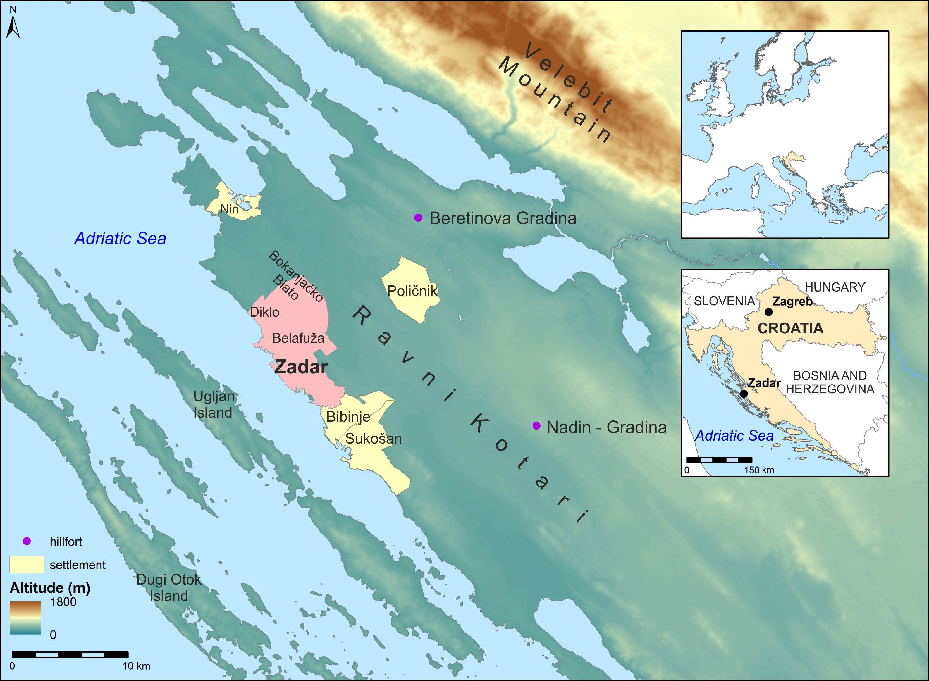
Figure 1 Geography of the study region and place names mentioned in the text (data pulled from European Environment Agency, 2016; State Geodetic Administration, 2016; European Environment Agency, 2018).
The area surrounding the city, known as Ravni Kotari, is a karstic region characterized by small hills interspersed with low, relatively flat areas of flysch deposits (Ilijanić et al., 2018, 67). The interior is geographically bordered by Velebit Mountain to the north and east, which reaches elevations of about 1,500 m.a.s.l. and acts as an ecotonal boundary between the interior Balkan Peninsula and the Adriatic Sea (Roglić, 1962). The climate along Croatia’s central and southern Adriatic coast is consistent with Köppen classification Csa, Mediterranean with hot and dry summers (Šegota and Filipčić, 2003). Vegetation across the Ravni Kotari is conditioned by its karstic terrain, Mediterranean climate, and human activities over the course of millennia. Typical vegetation includes macchia and garrigue, with evergreen shrubs, bushes, and oak trees (Ilijanić et al., 2018, 68). As one of the few low-lying and fertile regions along Croatia’s rugged coastline, Ravni Kotari has traditionally been the setting for a wealth of agricultural and livestock economies (Čuka et al., 2012). The eastern Adriatic Sea is also characterized by an array of small islands and marine channels that have provided protective harbors for the region’s long history of seafaring and fishing (Forenbaher, 1999; Forenbaher, 2009).
Broadly, climate in the region has trended toward more arid conditions since the mid-Holocene, becoming similar to that of the present-day Mediterranean by the Late Holocene (Finné et al., 2011, 3,164). Paleoenvironmental records from a stalagmite in Strašna peć Cave on Dugi Otok, the outermost island off the coast of Zadar, reflect this transition to a hot and dry Mediterranean climate in the Adriatic around 1000 BCE (Lončar et al., 2019, 103). At a continental scale, Büntgen et al. (2011) generated tree-ring based precipitation and temperature records for Late Holocene central Europe. They observe generally above average spring precipitation during the Late Iron Age and Early Roman Period (ca. 300 BCE–250 CE), followed by exceptional climate variability for the period ca. 250–550 CE. Spring precipitation and summer temperatures began to increase from the end of the sixth century CE, approximating favorable Early Roman conditions again by the ninth century. Reduced climate variability is also observed for the period 700–1000 CE. Wetter summers during the thirteenth and fourteenth centuries and a trend toward cooler conditions ca. 1300 CE are thought to correspond to the onset of the Little Ice Age (Büntgen et al., 2011, 580). However, at subcontinental and regional scales, the degree and frequency of temperature and precipitation changes can vary significantly from these broader continental trends (McCormick et al., 2012; Luterbacher et al., 2016).
Climate predictions over the coming century suggest that most landscapes across the Mediterranean will see hotter and drier summers with warmer winters. Interannual variability is anticipated to increase, as is the general occurrence of extreme heat and drought events. For parts of the Adriatic, this could translate to 20–30% declines in summer precipitation by 2100, and temperature increases by 2–4°C over the same period (Giorgi and Lionello, 2008). Despite a general trend toward drier summer conditions in the Mediterranean, episodes of severe precipitation and flooding may also become more frequent (Christensen and Christensen, 2003). In addition to more extreme weather events, sea level rise in the eastern Adriatic over the coming century is likely to leave low lying coastal zones more vulnerable to flooding and erosion. In the Zadar region, sea level is predicted to rise between approximately 32 and 73 cm by 2100, under intermediate (SSP2-4.5) future greenhouse gas emissions scenarios (NASA, 2023).
This study draws from a range of published source data to reconstruct relative changes in urban landcover and green space from Zadar’s foundations in the early first millennium BCE to the modern era. Urban landcover in this context refers to the (generally) nucleated arrangement of residential, religious, commercial, industrial, and/or other public and private forms of architecture, along with streets, open squares, courtyards, and other urban recreational spaces. Extensively published archaeological and historical works in Croatian, Italian, and English languages are utilized to reconstruct and calculate spatial changes in the urban built environment through successive cultural historical epochs (e.g., Iron Age, Antiquity, Middle Ages, Early Modern Era). To document changes in the rural landscape surrounding the urban center (i.e., green space), we utilize a range of information, including existing pollen and macrofossil data from previously published and ongoing archaeological work in the region, emerging data on Roman land surveying in coastal Ravni Kotari and neighboring Ugljan Island, the Austrian cadastre survey conducted around the city in 1826, and historic aerial photographs taken by the Royal Air Force in 1944. Recent satellite and aerial imagery provide key insights into contemporary urban landcover change, whereas population estimates and census records produce complementary information about the growth of the city into the twenty-first century.
Zadar was selected as a case study because of its long and continuous record of occupation since the Iron Age and its corresponding historic agricultural green space. Land use legacies stemming from Roman centuriation and historic field clearance practices have left one of the most distinctive and well-preserved physical manifestations of ancient and historic land use in the Mediterranean, offering an excellent opportunity to explore landcover change and green space through time. The city’s moderate size, which includes a nucleated and mono-centric historic core surrounded by urban landcover and green space, also make it a manageable analytical unit to study in its entirety. Finally, the availability of early nineteenth century cartography, mid-twentieth century aerial photography, and surviving relics of historic field systems provide a unique opportunity to document the pace of urban landcover change, loss of green space, and its potential to build resilience capacity into the twenty first century.
Zadar’s earliest manifestation of settlement dates to the Liburnian Iron Age in the early first millennium BCE (Batović, 1964; Čondić, 2010; Čondić and Vuković, 2017). Liburnian culture is distinctive of the Late Bronze and Iron Ages in the eastern Adriatic, whose territory is traditionally considered to have extended from the Raša River in the north to the Krka River in the south (Batović, 1965; Batović, 1983; Batović, 1987; Blečić Kavur and Podrug, 2014, 87–89). Although the Ravni Kotari was home to a number of Liburnian Iron Age hillforts, some of which would ultimately become Roman municipia (Batović, 1977; Čelhar, 2014), Zadar was the largest and most pronounced of these settlements, transforming into a Roman colony in the province of Dalmatia in the first century BCE (Wilkes, 1969, 206–207; Suić, 2003, 38–39; Čače, 2006).
Despite its prominence, characterizing the earliest settlement beneath Zadar remains challenging because of its long, continuous occupational history. The coupled effects of rising sea level (Brusić, 2001, 47; Čondić, 2010, 44; Parica, 2021, 141–143) and the city’s three thousand years of urban development into the twenty first century have left much of Zadar’s earliest foundations deeply buried, inaccessible, or destroyed. Yet, a number of isolated and opportunistic excavations within the historic peninsular city, particularly during post-World War II reconstruction, provide small but important glimpses into Zadar’s early settlement. Evidence is primarily limited to deeply stratified clay surfaces, segments of drystone alignments, and fragments of both locally-produced coarse ware and imported pottery (Čondić, 2010; Čondić and Vuković, 2017). These earliest settlement deposits are dated primarily by their association with fragments of high-quality imported pottery, the most abundant of which are those from Daunian (Matt-painted pottery) and various Greek workshops (e.g., Corinthian, Attic black- and red-figure pottery), followed later by numerous Hellenistic wares (e.g., late South Italian red-figure pottery, Gnathia pottery, black-glazed pottery) during the Late Iron Age (Čondić and Vuković, 2017, 53–62, 74–99).
The spatial distribution of Iron Age deposits beneath Zadar suggests the settlement occupied most of the peninsular area during this period, although material evidence is most concentrated on the northwestern half of the peninsula and decreasing toward the southeast (Čondić and Vuković, 2017, 27). The extent of the settlement to the southeast remains somewhat ambiguous, as no remains of a fortification wall have been identified. However, recent rescue excavations near the Roman city gate in the southeastern portion of the peninsula identified Liburnian drystone walls, hearths, and accompanying material culture that testify to the Early Iron Age settlement on this part of the peninsula as well (Vučić and Manenica, 2015, 7, 12–15, 33). Liburnian graves, normally placed outside the town walls, extended along the southeastern margin of the peninsula and into the present-day neighborhood of Relja, also the location of a pronounced Roman era cemetery (Čondić and Vuković, 2017, 30–31). In Relja, remains of Liburnian port structures were also exposed, indicating that the Bay of Jazine extended much farther into the mainland during the Iron Age than it does today. These port structures consisted of parallel lines of drywalls with large quantities of imported ceramic material, and the wooden lining of presumed wells, as massive wooden logs were documented near two springs in the limestone substrate (Brusić, 2001). In general, current evidence, although fragmentary, strongly suggests that Zadar’s Liburnian settlement was mostly restricted to the defensible coastal peninsula (Figure 2A).
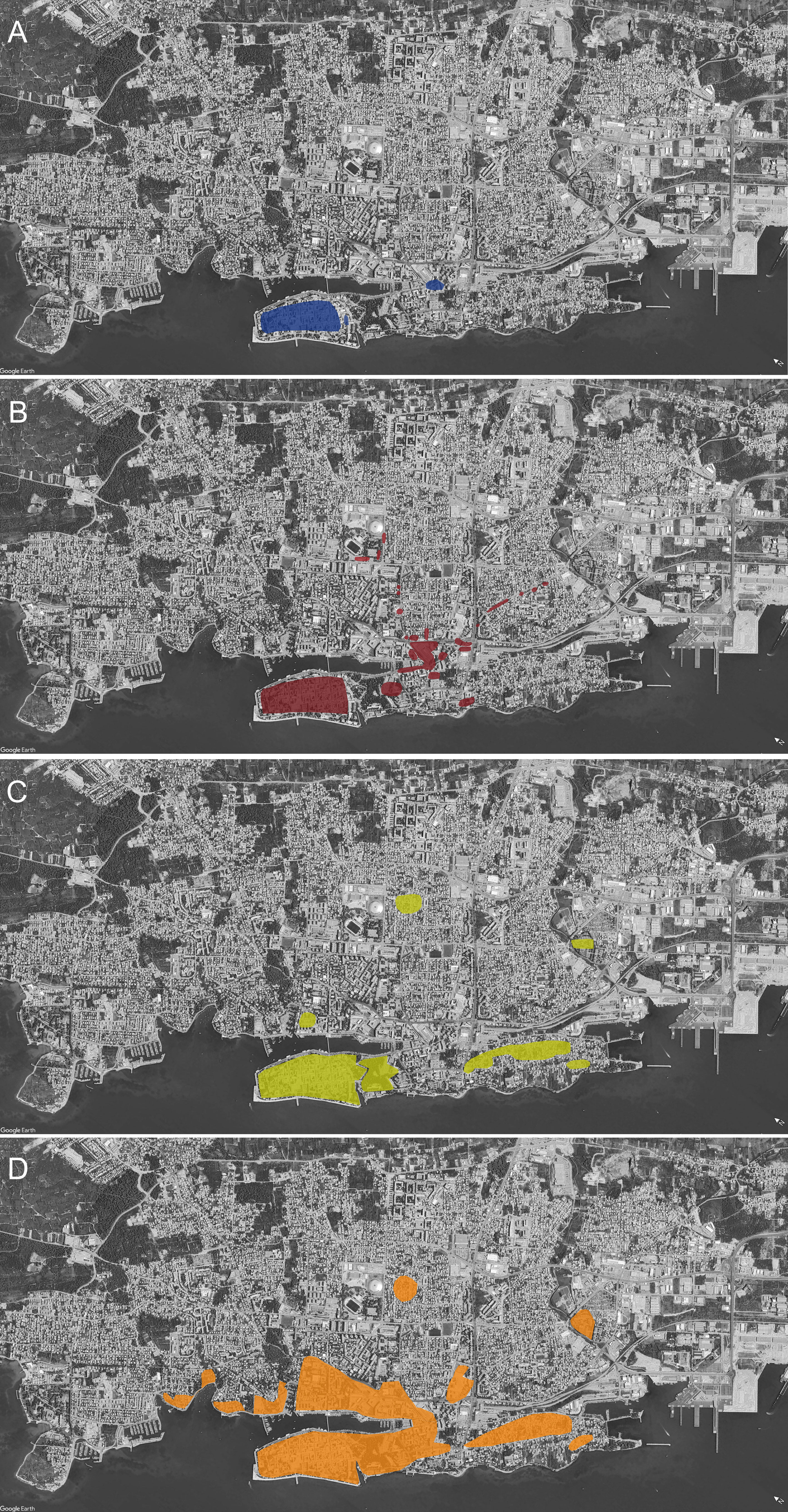
Figure 2 Zadar’s urban land cover through time (residential, commercial, other built-up spaces): (A) Iron Age; (B) Antiquity; (C) Early Nineteenth Century (D) Early Twentieth Century. Shaded areas were drawn from published archaeological reports, historical cartography, and aerial photographs. Base satellite image taken from Google Earth (imagery date: September 2022).
To date, few investigations have focused on the Liburnian built environment. Work at the Beretinova Gradina hillfort near Radovin settlement (Batović, 1968) and more recently at the Nadin-Gradina hillfort (Čelhar and Zaro, 2016; Čelhar and Zaro, 2017; Zaro and Čelhar, 2018; Kukoč and Čelhar, 2019; Čelhar and Zaro, In Press a; Čelhar and Zaro, In Press b) provides an illustration of the material construction and spatial organization of Liburnian hillforts generally. Excavations at both sites revealed deeply stratified clay surfaces, post holes, pits, drystone walls, stone alignments or enclosures, and other features of the Iron Age urban landscape. At the Beretinova Gradina hillfort, 18 km to the northeast of Zadar, broad excavations exposed a series of rectangular structures measuring approximately 5 × 8 m each that formed a ring along the interior perimeter of the hillfort. By the Late Iron Age and Early Roman periods, the settlement had expanded to cover much of the hillfort area (Batović, 1968). Ongoing work at the Nadin-Gradina hillfort, approximately 23 km to the east-southeast of Zadar, presents a similar picture, with Late Bronze Age or Early Iron Age domestic architecture positioned close to the interior face of the defensive wall, and construction expanding inward by the Late Iron Age (Čelhar and Zaro, In Press b). As is characteristic of other Liburnian hillforts, the Iron Age flat necropolis at Nadin is situated just outside the fortification wall. It was spatially organized around an irregular “grid” of grave plots defined by enclosure walls of large, undressed stone blocks containing one, two, or four graves, and mostly lined with slab stones. Late Iron Age collective graves have a more rectangular ground plan, are more formally arranged, and are delineated by large stone blocks (Kukoč and Čelhar, 2019).
Reconstructing the immediate landscape around Liburnian Zadar remains difficult, but paleoenvironmental and archaeobotanical data from nearby locations offer a general interpretation of the interior landscapes of Ravni Kotari that may also have been characteristic of those immediately surrounding Zadar during the Iron Age. Based on a synthesis of pollen and plant macro-fossil records of the Croatian coast (Šoštarić, 2005), the region (broadly) saw a decline in Juniperus and a spread in Erica from approximately 3100–1300 BCE, the latter of which is argued to be the result of anthropogenic burning and/or grazing during the Eneolithic and Bronze Age. This is followed by a relative rise in the proportion of pine (Pinus) and walnut (Juglans) in the Iron Age, and the appearance of chestnut (Castanea) and other species resulting from human activity (Šoštarić, 2005, 385–386). Pollen from the Bokanjačko Blato sediment core, a former wetland near Zadar, generally aligns with this overall picture, suggesting a decline in forest vegetation by at least the second millennium BCE, possibly from forest clearance, and the presence of cereals, walnut, chestnut, grape, and olive, with the latter two becoming more pronounced in upper levels (Grüger, 1996, 36–43). Most recently, archaeobotanical collections from Iron Age deposits at Nadin-Gradina also reflect a mixed landscape. In addition to a range of woody species, among which the most represented come from vine (Vitis vinifera), cereals are commonly represented in the assemblage and dominated by barley (Hordeum vulgare), along with millet (Panicum miliaceum), and to lesser extents, lentils (Lens culinaris), lentil vetch (Vicia ervilia), and beans (Vicia faba) (Nye, 1996; Knežić, 2022). Although the particular ecologies surrounding Zadar during the Iron Age have not been investigated, it seems reasonable to suggest that much of its surrounding mainland terrain may have been similar to those reconstructed for the interior Ravni Kotari, characterized by mixed subsistence spaces of cultivated, wooded, and grassy landcover.
Zadar evolved into a Roman colony in the province of Dalmatia late in the first century BCE, with a number of somewhat smaller but pronounced municipia scattered across Ravni Kotari (Wilkes, 1969; Suić, 1981; Starac, 2006). The heart of Roman Zadar continued to be the narrow peninsula, with a few small built-up spaces on the nearby mainland (Figure 2B). The Antique town center was characterized by residential blocks, marketplaces, administrative and religious complexes, urban recreational spaces, and an orthogonal pattern of streets aligned with the primary cardo and decumanus, which intersected at the forum (Suić, 2003, 209, 297–299). Major portions of the Roman city, including the forum, capitolium, baths, markets, and other infrastructure, were at least partially excavated during the immediate aftermath of World War II (Suić, 1981; Suić, 2003), providing narrow glimpses into the developed urban form of Zadar during Classical Antiquity (Figure 3). The area of the forum and capitolium became the focus of the early Christian center in Late Antiquity and the Early Middle Ages, which developed within the existing layout of Roman era city streets (Vežić, 1993; Uglešić, 2002; Vežić, 2005; Mišković, 2020). Notable is the early Christian cathedral dedicated to St. Peter (today’s St. Anastasia), located along the decumanus in the area of the Roman forum. Its origin in Late Antiquity (fifth to sixth century CE) has been confirmed through archaeological excavation and conservation (Vežić, 1993; Vežić, 2005). A defensive wall was constructed around the entire perimeter of the peninsular city, which was subsequently renovated or replaced by a new Late Antique construction with inclusions of spolia (Suić, 2003, 198, Figures 60 and 61; Jović Gazić, 2011, 186–189). Additionally, Brunelli (1913, 135) conveys the late seventeenth century writings of Dalmatian historian Ivan Lučić (Johannes Lucius), who mentions the ruined stones of an amphitheater just beyond the walled city to the southeast at the site of the seventeenth century Venetian Mezzalun fort. His writings also refer to an inscription associated with the fort, indicating it to be at the location of a former Roman amphitheater (Brunelli, 1913, 136).
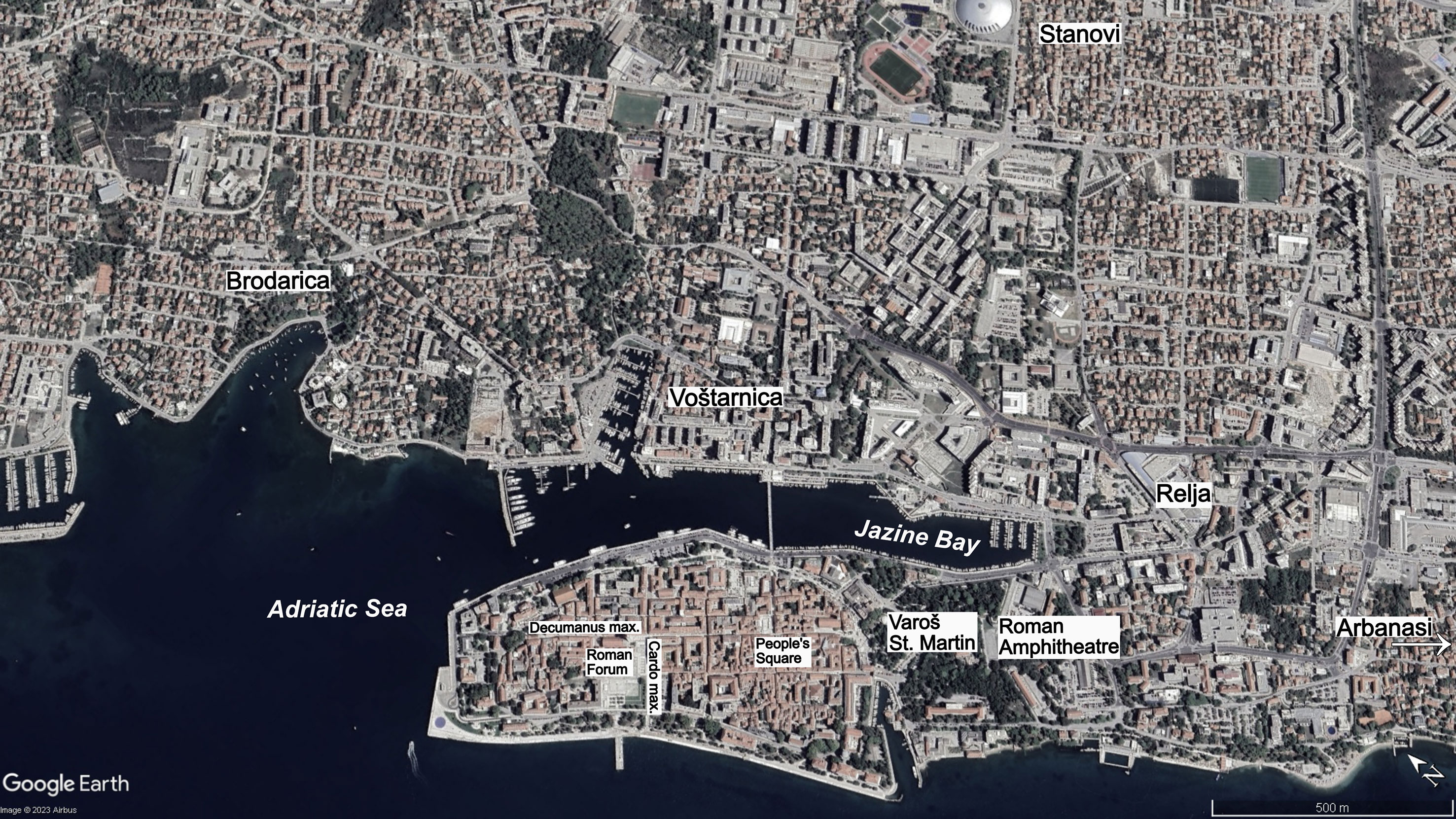
Figure 3 Zadar’s historic urban core and placenames mentioned in the text. Base satellite image taken from Google Earth (imagery date: September 2022).
Outside the city walls, apart from residential spaces, the most common built-up areas were for inns, lodgings, workshops, and public facilities (Suić, 2003, 319–320). Although there is little archaeological indication of these early suburbs, the most likely direction of urban landcover expansion, given the peninsular nature of the city, would have been beyond the fortification walls to the southeast, where the medieval suburb Varoš later developed (Vežić, 2001, 210). Because of Zadar’s current urban landcover, ancient roads extending outward into the countryside have been archaeologically confirmed in only a few locations and in very small segments (Nedved, 1980, 345–354; Gluščević, 2005, 217, 243; Maurin, 2012, 569). However, these primary routes were important because they not only connected suburban areas to the city center, but they also established the initial framework onto which urban landcover could initially expand.
Roman necropoli constituted an important built-up space beyond the city walls and were largely positioned along primary roads leading out from the fortified city center. Their spatial organization reflected that of the city, stretching along roads, sometimes for kilometers, and with additional side streets. Wealthier families owned burial plots along primary and secondary streets within the necropolis, mirroring the regular grid of city streets and insulas (Suić, 2003, 318; Serventi and Jurjević, 2012, 201). Although Roman graves have been discovered in a much wider area (Suić, 2003; Gluščević, 2005, 161, 318), the central part of Zadar’s Roman necropolis was situated along one of the primary roads leading out to Ravni Kotari, in Zadar’s present-day neighborhood of Relja where earlier Iron Age graves had also been recorded (see Figures 2B, 3). Over the past century, archaeologists have identified more than 2,000 Roman-era burials, generally dated from the first century BCE to the fourth century CE (Nedved, 1980, 341–345; Gluščević, 1990, 107–110; Suić, 2003 Gluščević, 2005; Fadić, 2007a, 347–349; Fadić, 2007b, 350–351; Alihodžić, 2009, 508; Perović and Fadić, 2009, 55; Alihodžić, 2010, 541; Vučić, 2010, 540; Maurin and Paraman, 2013, 648; Serventi, 2014, 161, 318; Alihodžić, 2015, 528).
Roman villas or estates have also been documented around Zadar and form another small category of built-up space. They played important economic roles in the production of food and other products and consequently served to connect the city and countryside (Suić, 2003, 315–338). The remains of several villas have been archaeologically recorded in the vicinity of the necropolis in Relja (Suić, 1960, 208; Gluščević, 2005, 92–95, 246–247). Others have been identified north along the coast between Zadar and Nin (Fadić, 1986, 90–91; Begović and Schrunk, 2002, 119; Jurjević, 2020, 522–523, 534–535; Uglešić, 2021, 224) and along the coast to the south toward Sukošan (Pešić, 2017, 15; Begović and Schrunk, 2002, 119; Jurjević, 2020, 526, 528, 538–539, 541; Jurković Pešić and Grgurić, 2022, 130). There were most certainly additional villas toward the interior of mainland Zadar, but contemporary urban development makes their investigation difficult.
The legacies of centuriation, or Roman land survey, provide the most important indication of land use and green space surrounding the city during Antiquity. Centuriation was a form of Roman land division where surveyors (agrimensores) were commissioned to delineate cultivable land within a newly acquired territory (Campbell, 2000). Farmland for the colony was laid out through the use of a groma – a cross-shaped implement – to extend two lines at right angles, effectively establishing the centuriated grid (Stambaugh, 1988, 248). Written sources note that agrimensores were primarily responsible for dividing land for government, local communities, individuals, and colonial settlements (Campbell, 2000, liv).
Roman land distribution grids are visible across many Mediterranean landscapes today, including the Iberian Peninsula, the Apennine Peninsula, Dalmatia, and North Africa, and they reflect the imposition of Roman imperialism on distant territories (Bradford, 1957; Roselaar, 2010; Palet and Orengo, 2011; Boatwright et al., 2012; Kadi, 2016; Kadi, 2020). From an archaeological perspective, they remain some of the most tangible pieces of evidence of Roman land survey and allocation, often expressed today in the form of orthogonal systems of roads and field boundaries. Their legacies are occasionally visible through the fabric of contemporary urban landcover as well, the expansion of which often consumed cultivable lands at the margins of colonial cityscapes (Bradford, 1957; Suić, 2003; Brigand, 2009; Kadi, 2020).
In the eastern Adriatic, Royal Air Force images of the 1940s captured centuriated field systems around the cities of Pula, Zadar, and Split (Bradford, 1947; Bradford, 1957). Aerial imagery of Zadar displays a clearly demarcated grid on the mainland, generally oriented northwest–southeast in coordination with the coastline (Figure 4). The major grid lines are spaced approximately 710 m apart, consistent with patterns of Roman centuria quadrata identified elsewhere (Bradford, 1947, 197). Roman centuriae around Zadar have traditionally been interpreted to have extended from Diklo in the northwest to Sukošan in the southeast, and to Musapstan in the north (Bradford, 1947, 197; Suić, 1955; Suić, 1981, 148–156; Jakšić, 1986; Maršić, 1993; Suić, 2003, 166). However, recent and ongoing work is reevaluating this assessment, suggesting that the ager around Zadar was much larger than traditionally described. Centuriated grids have been identified on Ugljan Island just across the channel from Zadar (Suić, 2003; Kadi, 2016), and additional evidence indicates that the northern border of the ager around Zadar may have extended as far as Poličnik (Kadi, 2020) (see Figure 1). Ongoing work suggests the northwestern border may have extended beyond Diklo as well.
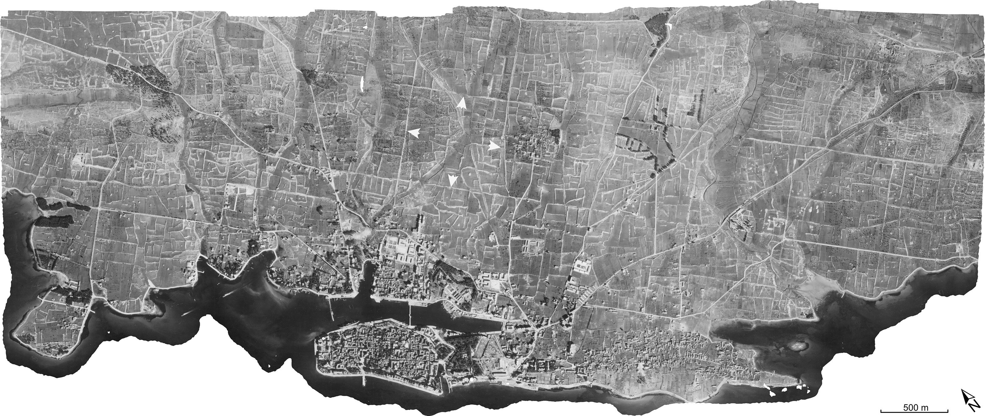
Figure 4 Orthomosaic image of Zadar created in Agisoft Photoscan software, composed from a series of seven Royal Air Force photos from 1944. Roman centuriation is visible in the form of broad and regularly spaced orthogonal lines (white arrows indicate examples). The semi-regular and organic pattern of smaller, rectilinear features reflects an agricultural landscape of drystone walls and cairns. Construction dates of these latter features are not currently known, but they likely formed prior to the early nineteenth century Austrian cadastre survey. Royal Air Force imagery courtesy of Geodetski zavod d.d. Split, Croatia.
Beyond the centuriated grid lines, there is little direct evidence to characterize the cultivated landscape surrounding Zadar. Archaeobotanical data from Nadin-Gradina in central Ravni Kotari point to some variation in the agricultural landscape as it evolved from the Iron Age into Classical Antiquity. As noted earlier, samples recovered from Iron Age deposits reflect a mixed landscape with diversified prehistoric cereal agriculture. Nadin-Gradina samples from the first to third centuries CE suggest a decline in cereals and legumes when compared to Iron Age deposits, or at least a shift from their processing within the hillfort. Concurrently, olive pit fragments (Olea europaea) begin to appear more regularly in Late Iron Age or Early Roman era samples, and they become the most common macrobotanical find (behind wood charcoal) among first to third century CE deposits. This may point to a shift from an open landscape of diversified cereal agriculture in the Iron Age to an intensified form of olive-focused arboriculture and other fruits during the Roman era (Countryman et al., in press). Nearby on Ugljan Island, where olive groves in various states of management are common across the landscape today, the ruins of a Roman period mill and villa complex lie at its northern end, further suggesting the importance of oil processing during this era (Ilakovac, 1997). Regardless of the specific composition of the agrarian landscape surrounding Zadar, the distribution of relict Roman survey lines would indicate that agricultural green space characterized most of the mainland terrain around the historic urban core of the peninsular city. The placement of possible Late Antique watchtower forts across portions of the ager closest to the city, as interpreted from toponyms recorded in historic city records from the thirteenth to the seventeenth centuries (Smiljanić, 2010, 399–413), would further testify to the value placed on these cultivated spaces by city officials during the Late Roman era. Today, the centuriated grid near Zadar remains one of the best preserved examples of Roman land survey in the Mediterranean.
The Middle Ages and Early Modern Era are marked by significant political change, where Zadar’s affiliation transferred from the Byzantine Empire, to the Kingdom of Croatia, to the Kingdom of Hungary (Klaić and Petricioli, 1976). In 1409, Zadar fell under the control of the Venetian Republic, which continued until 1797 (Raukar et al., 1987). The city’s geographic position on the eastern Adriatic coast made it a desirable location and safe harbor along trade routes to the east, which was crucial for Venetian maritime interests.
Although the peninsular setting of the historic city constituted a spatial limitation to Zadar’s growth, Jović Gazić (2011, 186) points out that maintaining the Classical Antique perimeter was a common phenomenon in the transition from Late Antiquity to the Middle Ages and is apparent among many Central European towns with long-term urban continuity. This was the case with medieval Zadar, which retained its basic urban form from the Roman period. In addition to a range of different public and private buildings, churches and monasteries were a focus of major construction activities in the Early Middle Ages (Klaić and Petricioli, 1976; Mišković, 2020). The Late Antique Christian cathedral was no longer dedicated to St. Peter but rather to St. Anastasia and was thoroughly rebuilt over the remains of the earlier edifice (Klaić and Petricioli, 1976). An iconic example of monumental church construction is the ninth century church of St. Donat – a cultural-historical symbol of Zadar today. It was constructed near the cathedral of St. Anastasia, utilizing significant spolia from the Roman forum in its foundations (Vežić, 2002) (Figure 5). Much of the built environment in Late Antiquity and the Early Middle Ages mapped onto the existing Roman grid of streets, but this pattern began to shift by the later Middle Ages (Klaić and Petricioli, 1976, 278). The administrative center of the city also relocated from Roman times, from the capitolium and forum on the west side to the Platea Magna, today’s People’s Square, toward the southeast (see Figure 3). This new focal point of the peninsular city was also surrounded by public buildings, like the Palace of the City Council and the City Lodge (Petricioli, 1965a, 160–162; Klaić and Petricioli, 1976, 280; Raukar, 1977, 19). Zadar’s medieval walls were gradually constructed and reinforced, gaining their final medieval appearance in the thirteenth century and providing further spatial definition and continuity to the urban center. The evolution of fortification walls delineating the city is most evident today in the southeastern portion of the peninsula near Petar Zoranić square, where segments of fortification walls from Classical Antiquity, Late Antiquity, and the Middle Ages are preserved in close proximity and parallel to one another (Figure 6) (Fadić and Štefanac, 2011; Jović Gazić, 2011, 186–187; Vučić and Manenica, 2015, 12–13).
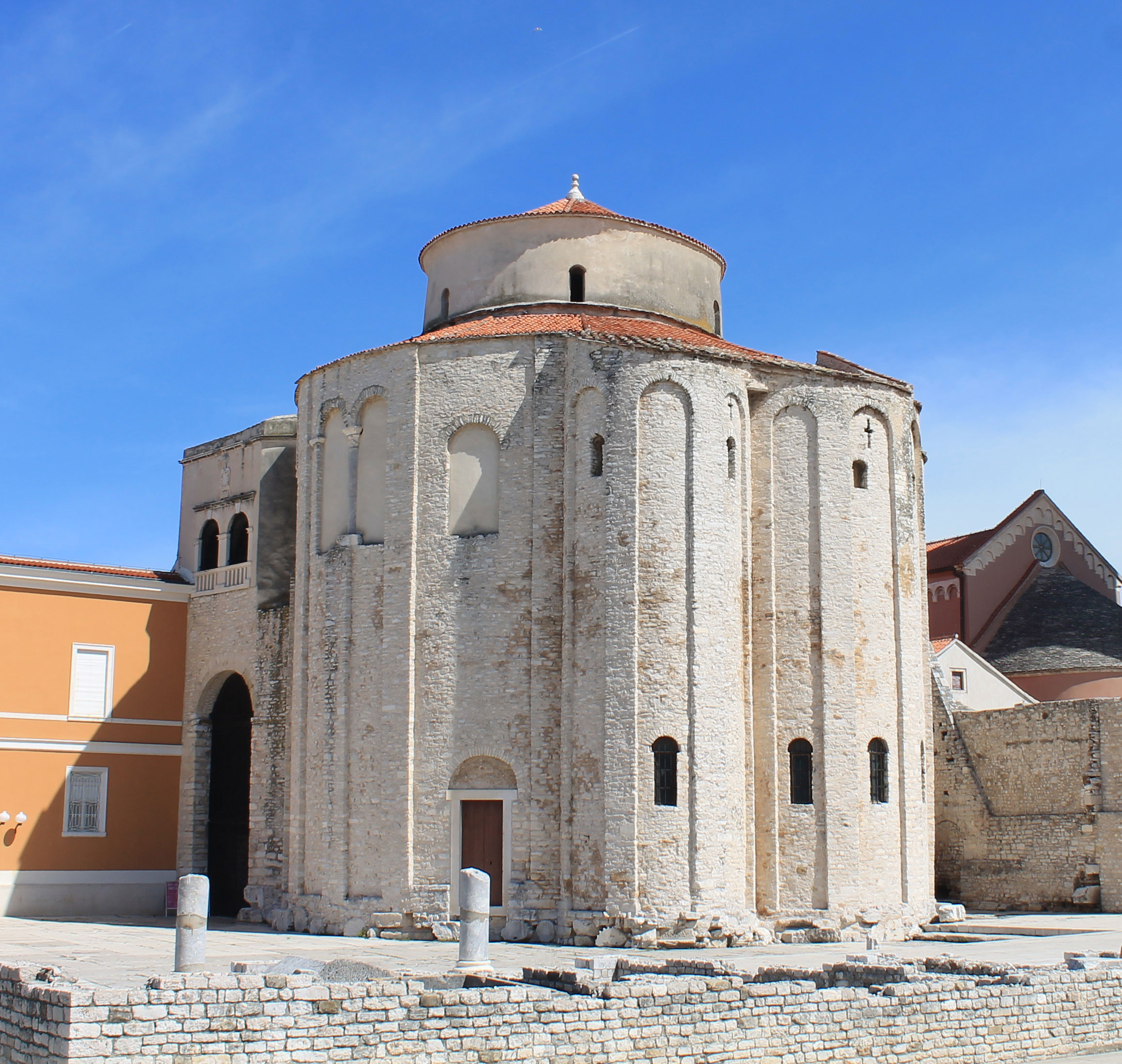
Figure 5 Ninth century church of St. Donat in the area of Zadar’s Roman forum. Note the heavy use of spolia in its foundation. Restored foundation walls of Roman tabernae in the forum are visible in the foreground. (Photo credit: G. Zaro).
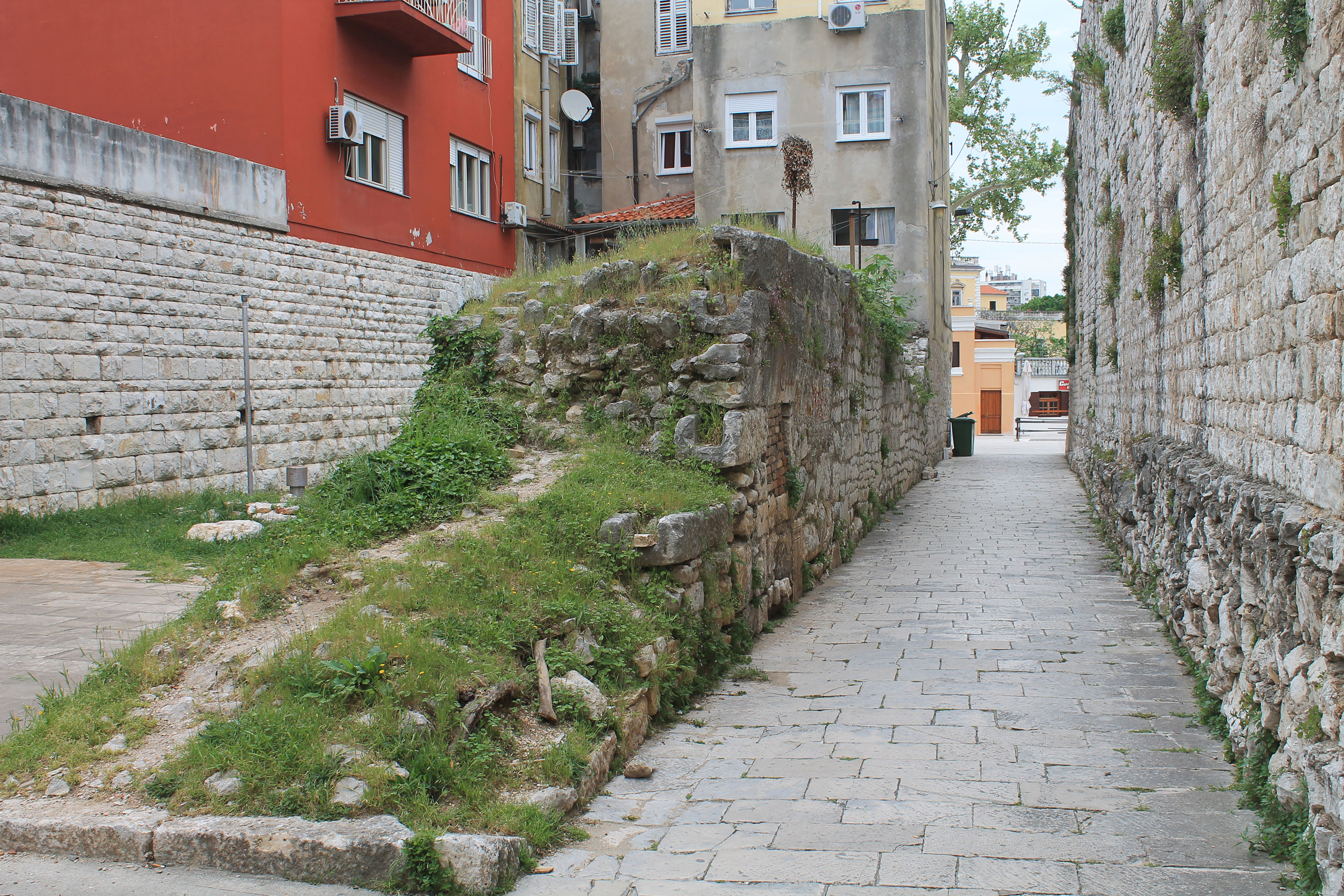
Figure 6 Segments of fortification walls along the southeast margin of the peninsula. Left: Classical Antiquity; Center: Late Antiquity; Right: Middle Ages. (Photo credit: G. Zaro).
Historical sources mention the development of a small suburb, St. Martin (Varoš Sv. Martina), outside the city walls to the southeast. It was also enclosed by fortification walls and towers, but sparsely populated and associated with only country houses and gardens. In the Late Middle Ages, it was still very much characterized by agriculture and pastoralism (Petricioli, 1965a, 178–180; Petricioli, 1965b, 202; Raukar, 1977, 20). Opposite the harbor on the mainland were, among others, the churches of St. James, St. Peter, and St. John. Farther north, in what is now Belafuža, was the church of St. Mary, also referred to as de Roveris, de Quercus (of oak trees), and later Olivarum (of olive trees) (Petricioli, 1965a, 181). In some cases, the construction of churches across the landscape seemed to articulate with previously established Roman centuriae. The clearest example of this is the large tenth century estate of the monastery of St. Krševan, in the western part of the ager near Diklo, which measured the exact size of six centuriae and emphasized field cultivation (Jakšić, 1986). This correspondence between the positions of rural churches and Roman centuriae has also been observed for early Christian and medieval churches on nearby Ugljan Island (Kadi, 2016). Regarding cemeteries, medieval and Early Modern Era burials were mostly situated within town churches and monasteries or around them (Jurić, 2002; Jurić, 2008; Bekić et al., 2017; Gusar and Vujević, 2023). Outside the city walls, archaeological excavations confirmed that Relja was still in use as a cemetery during the Late Middle Ages as well, suggesting a degree of continuity in use of space since the Iron Age (Gusar and Vujević, 2010).
The most substantial changes to Zadar’s urban built environment came in the sixteenth century when, in response to the expansion of the Ottoman Empire from Anatolia to Southeastern Europe, the Venetian Republic replaced the dilapidated medieval walls with new renaissance bastion fortifications around the entire peninsular city (Raukar et al., 1987). Additional fortifications were also expanded over the former medieval suburb of Varoš St. Martin on the southeast margin of the peninsula (Petricioli, 1958, 121, Figure 1; Petricioli, 1965b, 202). Concurrently, through the construction of ditches, the fortified city was transformed into an island, further delineating the urban form and spatial organization of Zadar during the Early Modern Era. The heavily fortified city is depicted in an 1808 map, along with planned (but never executed) fortifications on the mainland across the harbor (Figure 7).
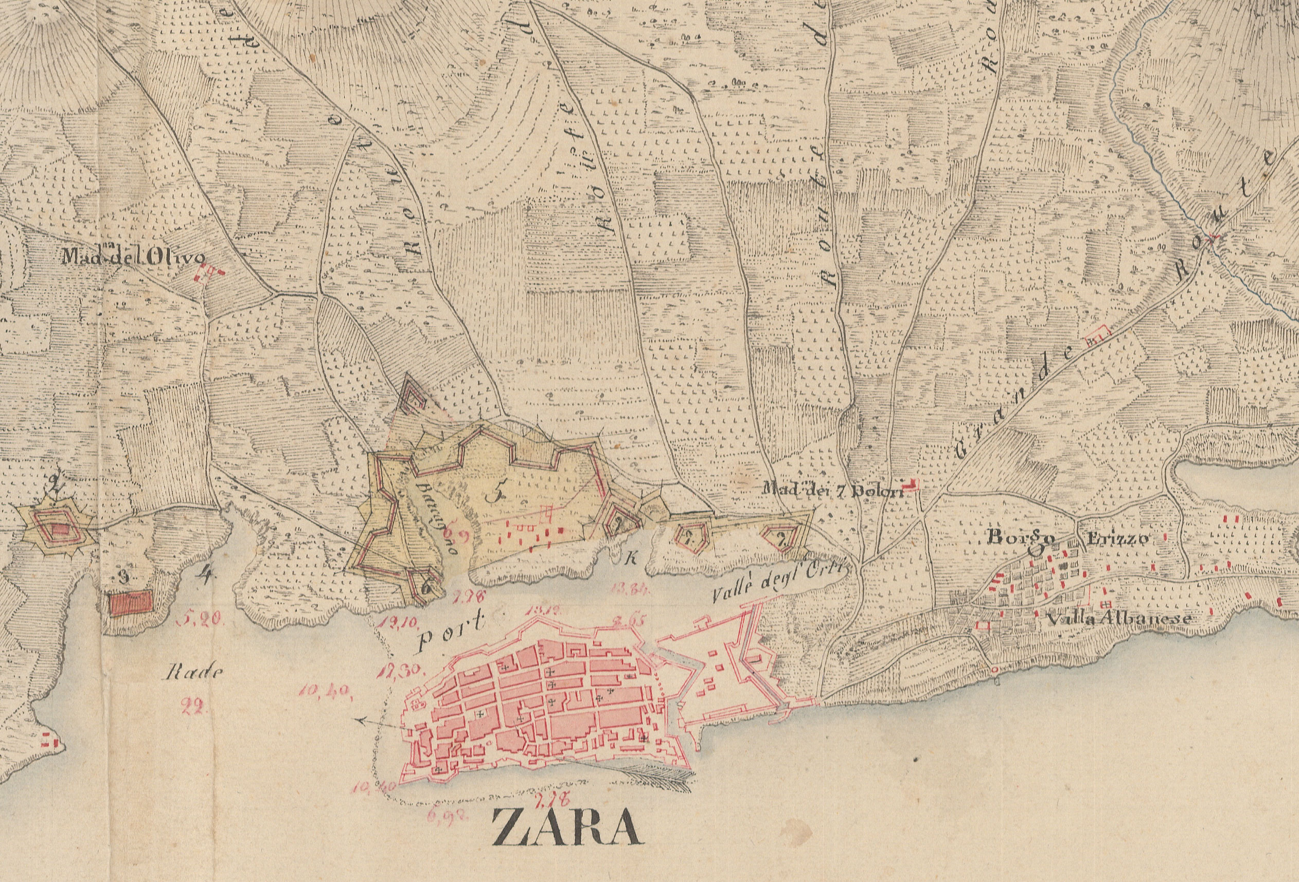
Figure 7 An 1808 depiction of Zadar showing the heavily fortified peninsular city and planned, but never executed, fortifications across the harbor (darker yellowish shading). The majority of terrain around the city continued to be agriculturally mixed green space. (HR-HDA-902, Cartographic Collection, K.VII.i.180, Croatian State Archive).
Zadar was the center of craft, maritime, trade, and financial activities whereas the landscape surrounding the medieval fortified city was largely agrarian, characterized by cultivated fields, gardens, and votive churches (Raukar, 1977, 20–21). House lot gardens within the town were mostly reserved for fruits and vegetables, while infields on the mainland were dedicated to olive groves and vineyards. More distant fields were utilized for grain production. After sea salt, livestock, and wheat, vine was the most important product of most medieval Dalmatian towns (Raukar, 1977, 155–156). Written medieval documents also mention mulberries, melons, figs, plums, and the marasca cherry from which Zadar would later produce its notable liqueur, Maraschino (Peričić, 1999; Anzulović, 2010, 26, 163–166). In the sixteenth century, agricultural productivity around Zadar and its hinterland experienced a period of decline due, in part, to the Venetian-Ottoman wars, the resulting population loss, and the destruction of agricultural fields and technologies (Raukar et al., 1987, 244).
With the fall of the Venetian Republic in 1797, Zadar came under the rule of the Austrian Empire, then the French Empire in 1806, and again under Austria in 1813 (Peričić, 2011, 25–38). Zadar remained part of the Habsburg/Austro-Hungarian Empire until its dissolution in 1918 at the end of World War I. During the first period of Austrian and subsequent French rule, construction around Zadar was related primarily to military operations. The French used the town as a military camp, abolishing a number of churches and monasteries for the sake of warehouses and barracks (Peričić, 2011, 33; Stagličić, 2011, 265). In 1820, the town cemetery was established in its current location, well outside the city walls and just inland from today’s Gaženica port (Stagličić, 2011, 271). A second major renovation was the 1829 transformation of Bastion Grimani, located at the southeast margin of the fortified center, into a city park, but given the continued strategic importance of Zadar, a new fortification (Fortini) was built concurrently across the harbor from the historic peninsula (Stagličić, 2011, 272–273). Several decades later, after Zadar was declared a free city in 1868, the seaward portions of the peninsular fortification walls were demolished, with new residential and commercial buildings erected in their place by 1873 (Peričić, 2011, 209). In 1890, the Venetian fortress Forte, which protected Zadar along its southeastern margin, was also transformed into a public park (Peričić, 2011, 210). Venetian-era walls along the harbor and southeastern margin of the city persist today and are protected as a World Heritage Site (UNESCO, 2023). Zadar continued to urbanize at a moderate pace in the nineteenth century, and by the early twentieth century, the suburban settlements of Voštarnica, Brodarica, Borik, and Puntamika were established residential spaces (Stagličić, 2011, 325–326), all of which now lie within the boundaries of Zadar’s contemporary urban landcover (Figures 2C, D; see also Figure 3).
Cadastral survey records were an important component of land administration during this period and offer a glimpse of urban and rural landcover around Zadar during the early nineteenth century. Originating from the beginning of the nineteenth century when the Franciscan cadastre was introduced for the Austrian part of the Habsburg Monarchy, the Austrian cadastre survey provided descriptions of land use and spatial delineation of field and building plots for taxation and legal purposes (Navratil and Frank, 2004; Navratil et al., 2010; Timár and Biszak, 2010; Lisec and Navratil, 2014). Digitized survey data for the Zadar region document a nineteenth century mainland characterized by a mosaic of land use classifications (Arcanum, 2023). Several suburbs that formed in the early part of the previous century are also depicted on the map as building plots. The small settlement of Arbanasi (Borgo Erizzo) is noted to the southeast of the fortified city and near the coast. Across the harbor, the settlements of Voštarnica (Ceraria) and Stanovi (Babina) are noted along the marina and slightly more inland, respectively (Raukar et al., 1987, 547). The remainder of what is now mainland Zadar seems to have been characterized by a mosaic of green spaces that included grasslands, plough fields (wheat, barley, corn, oat, spelt), vineyards (vines and olive trees grown together), and gardens (Swiss chard, legumes, garlic, almond, figs, ornamental) (Figure 8). By the latter half of the nineteenth century, viticulture for wine production had intensified in Dalmatia (a nineteenth century coastal crown land of the Austrian Empire at that time) in response to severe declines in other European countries, primarily due to the appearance of the grapevine disease phylloxera (Čuka et al., 2017). In 1896, approximately 23% of the total Zadar area was covered in vines (Cesarsko kraljevska središnja statistička komisija, 1908). Other types of agricultural land use covered approximately 70% of the area, while unproductive land (built-up, water bodies) constituted the remaining 7% of the territory. By the early twentieth century, phylloxera had spread throughout most of Dalmatia as well, resulting in significant economic declines in viticulture (Čuka et al., 2017).
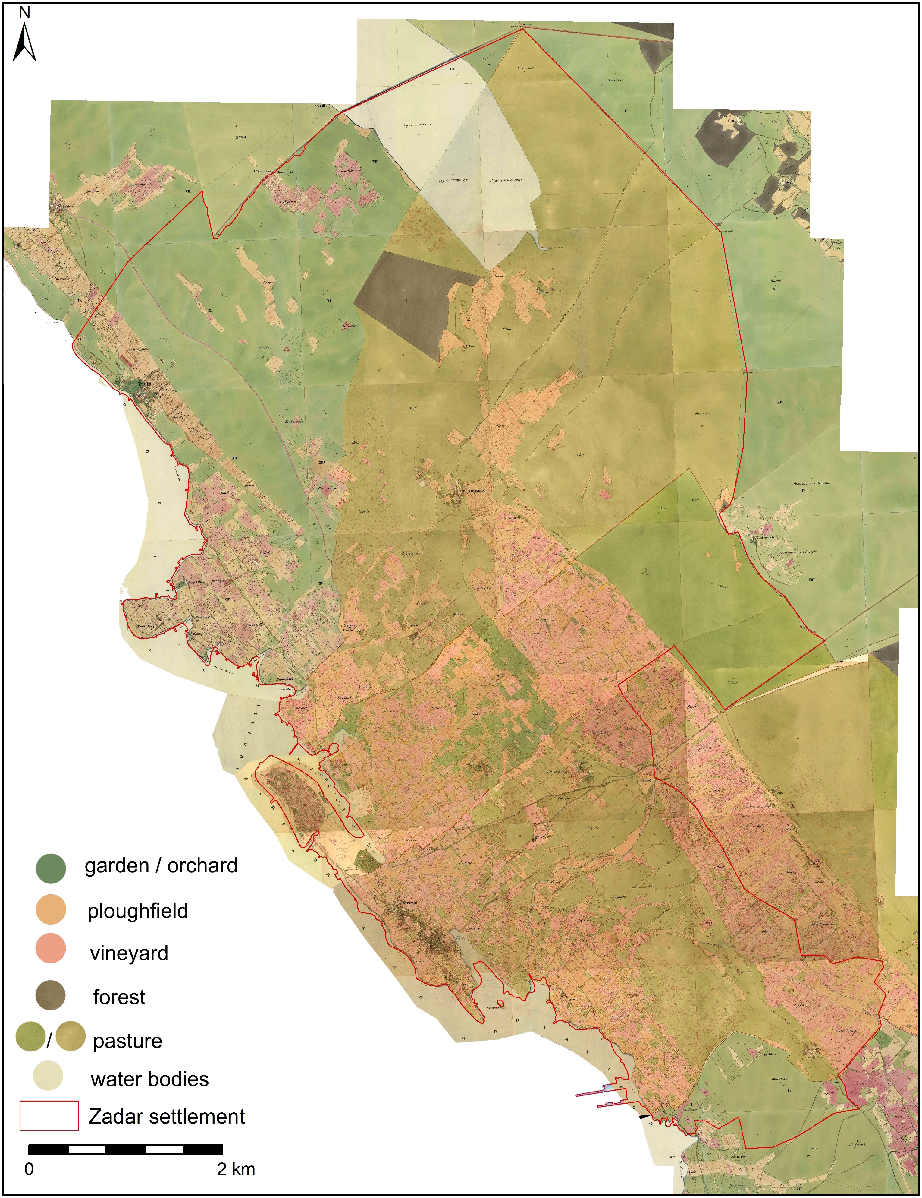
Figure 8 Digitized 1826 Austrian cadastre showing the mixed agricultural land use that characterized the mainland surrounding the peninsular city (State Geodetic Administration, 2016; Arcanum, 2023).
As is evident in aerial imagery of 1944, much of the mainland terrain immediately surrounding the historic nucleus of Zadar was covered by a matrix of drystone field walls, terraces, and cairns, interspersed among the Roman centuriated grid lines (see Figure 4). The arrangement of these landscape modifications in the eastern Adriatic reflects regular and irregular patterning driven largely by slope, aspect, and other local geophysical, cultural, and historical circumstances (Andlar et al., 2017; Andlar et al., 2018). Following the nomenclature of Andlar et al. (2018, 770–771), the drystone field boundaries and cairns visible in historic aerial imagery around Zadar may be described as enclosed karst clearings, which generally exhibit semi-regular to organic patterns of construction. These features constitute a classic form of landesque capital and are generally intended to improve a landscape for cultivable purposes (Brookfield, 2001; Håkansson and Widgren, 2014). Their construction clears field surfaces of stones and other debris, slows surface runoff, reduces soil erosion and nutrient loss, and improves water retention. These structures constituted a significant investment of labor at the time of their creation, but with regular maintenance, they became important elements of the landscape that benefited generations of farmers. However, as socioecological conditions surrounding their management change, such features may become partially devalued, abandoned, or even destroyed, the latter of which cancels out the centuries of “banked” labor they represent (Zaro, 2014, 246–247).
It is difficult to determine when this field architecture was constructed. Where Roman centuriation is evident, field walls often terminate at the margins of grid lines and so very likely post-date the Roman era. A cursory comparison of field wall distribution and the Austrian cadastre of the early nineteenth century shows some similarities between field walls and property boundaries, likely indicating they were at least partially formed by the time of that survey. Regardless of their time depth, these constructions clearly formed a significant piece of the cultural landscape and local green space well into the twentieth century and up to World War II.
From the middle of the twentieth century onward, Zadar’s urban landscape transformed dramatically, with urban landcover expanding rapidly onto the former agricultural landscape (see Figure 2). During World War II, Zadar was heavily bombarded, destroying or damaging 80% of its urban infrastructure (Mlikota, 2021, 143). In the post-war era, industrialization played an important role in its reconstruction and economic development, spurring a host of new factories and residential spaces needed for their workers. New constructions initially occurred along the narrow coastal zone but soon after moved inland onto these previously cultivable green spaces (Graovac, 2014).
The post-war growth in industry and commerce, coupled with inadequate investments in agriculture, drew more people from the rural countryside into the urban center. This situation was common across Croatia but was more pronounced among the coastal counties, and particularly in those regions with long urban histories (Njegač and Toskić, 1999, 267–269). Rural to urban migration continued to accelerate following the Croatian War of Independence in the 1990s and the dissolution of Yugoslavia. The shift from a planned to a market economy led to the closure of many factories and a transition to the service sector. In terms of urban landcover and spatial organization, this resulted in the demolition or renovation of former industrial buildings, which were frequently situated in attractive neighborhoods near the city center, and replaced with apartment complexes and other residential spaces, continuing the growth trend in residential infrastructure since World War II (Magaš, 2009).
Infrastructural projects in the transportation sector also facilitated Zadar’s growth across this period, particularly from the 1960s onward with the construction of the Adriatic highway, a railway connection, the international airport, and initial development of the port complex at Gaženica (Magaš, 2009, 278). The tourism industry in Zadar grew substantially, benefitting also from the construction of new hotels and roads (Brkić-Vejmelka, 2009). The number of tourist visits declined in the 1990s during the Croatian War of Independence, but rose substantially following the war, peaking in 2019 before the COVID-19 pandemic. The intensive growth of tourism in the twenty first century, especially after Croatia acceded to the European Union in 2013, also precipitated rapid construction of new apartment complexes as tourist rentals (Figure 9). The contemporary tourism industry in Zadar occurs predominantly during the summer months (Krce Miočić et al., 2016), with undoubtedly profound seasonal impacts on water and energy consumption, and on waste production and disposal. Moreover, the tourism industry may also have longer-term implications for urban spatial organization, real estate prices, and the persistence of green space.
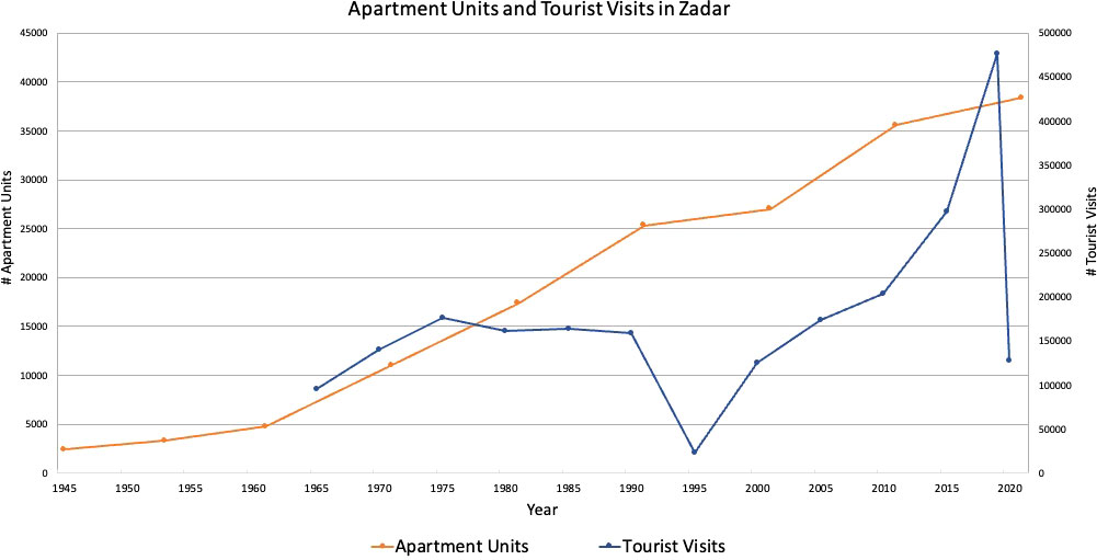
Figure 9 Growth in apartment units and tourist visits, mid twentieth century to 2020/2021 (Magaš, 2009; Croatian Bureau of Statistics, 2021; Croatian Bureau of Statistics, 2022). Significant declines in tourist visits during the 1990s and in 2020 correspond to the Croatian War of Independence and the COVID-19 pandemic, respectively.
Apart from the conversions of Bastion Grimani and Forte into city parks in 1829 and 1890, respectively, there are few green spaces on the historic peninsula. Intense bombing during World War II left many buildings around the forum and along the riva, or waterfront, in ruin. Upon clearance, the forum area was outfitted with mostly paving stones and left open to integrate the city’s archaeological heritage into a contemporary urban space (Rukavina and Obad Šćitaroci, 2017, 335), while newly cleared areas along the riva were transformed into a narrow, linear, tree-lined promenade and park. A small park, Gospa od zdravlja, also lies in the northern portion of the peninsula, established in the late nineteenth or early twentieth century. Most recently, the tree-lined street atop the Venetian fortification facing the harbor was converted to a pedestrian zone in 2020, effectively creating a linear park-like promenade similar to that along the riva. On the mainland, Magaš (2009, 334) notes that there was no planned concept for the distribution of greenery within the expanding cityscape. Rather, in sporadic cases, greenery was established or left to buffer noise pollution, offer privacy, or to maintain recreational parks, gardens, or residential/commercial greenery. Apart from tree-lined streets and other smaller green spaces, there are a few recreational parks that tend to be situated close to the historic center or sea. Historic agricultural fields or formerly cultivated spaces, which remain visible but unkept and scattered among various parts of the city, are generally not included in the discussion of these mostly manicured green areas.
Among these former agricultural green spaces, field architecture that was so pronounced and characteristic of the cultural landscape in 1944 is now derelict and overgrown (Figure 10). In those spaces closer to the coast or historic city center, many new multi-unit housing complexes or large apartment blocks have been quickly erected with many others under construction (Figure 11). Consequently, the last surviving drystone relicts that once dominated the centuries-to-millennia-old cultural landscape prior to this late twentieth century construction boom are rapidly disappearing (Figure 12). Outside of the few remaining historic green spaces, reflections of this pronounced agrarian past within the contemporary urban landcover of Zadar persist only in the alignment of major urban streets with former Roman centuriated grid lines, or in the occasional drystone wall that remains along the margins of streets or within private house lot gardens across the city. Unfortunately, the extent of this historically distinctive cultural landscape is not readily apparent to a majority of residents or visitors to the city.
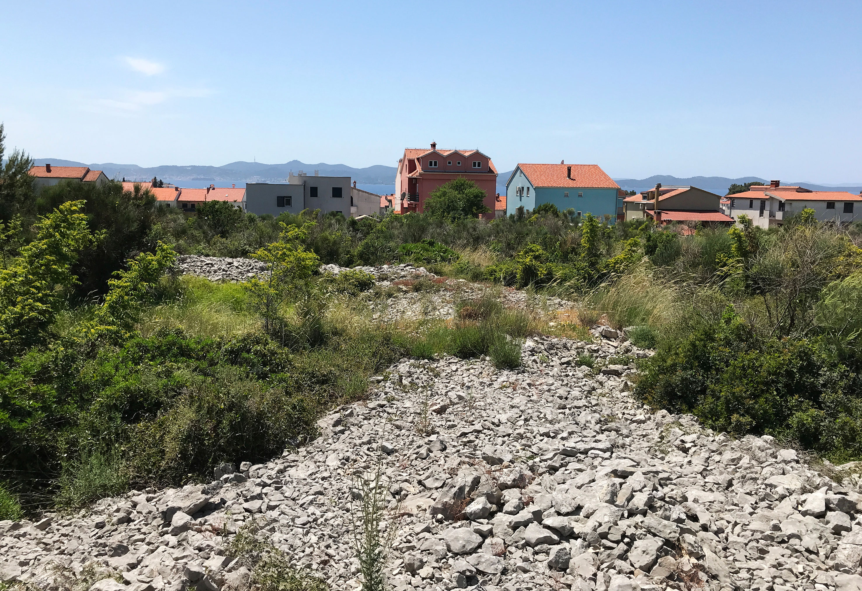
Figure 10 Derelict drystone walls within one of the remaining vestiges of Zadar’s urban green spaces. (Photo credit: G. Zaro).
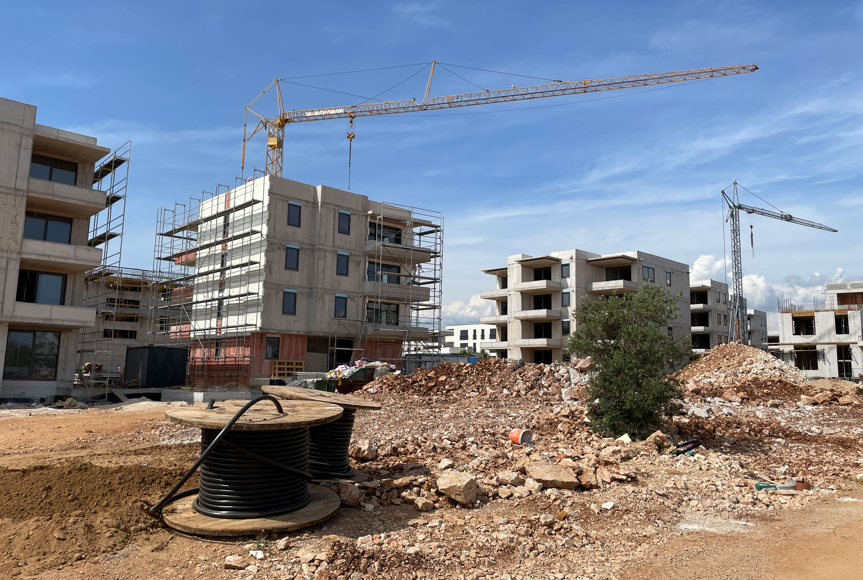
Figure 11 Multi-unit housing structures are replacing the last remaining vestiges of (formerly agricultural) urban green space and field architecture (drystone walls and cairns). Construction of apartment complexes on the space depicted here began less than a decade ago but has accelerated since 2019 to nearly cover the entire ~5 ha area. (Photo credit: G. Zaro).
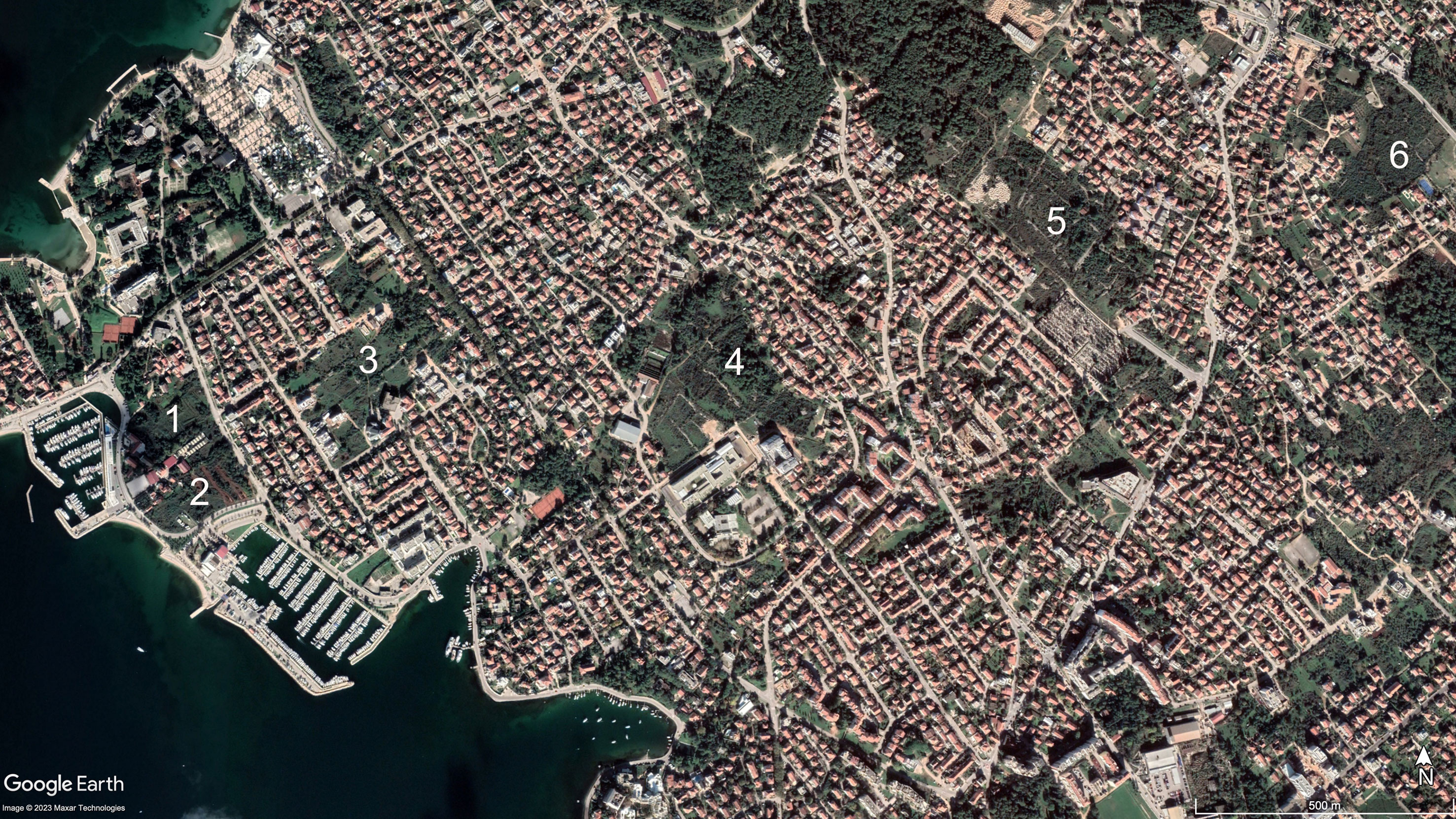
Figure 12 Google Earth satellite image of a portion of northwest Zadar showing examples of green spaces with historic agricultural field architecture. Areas 1, 2, and 3 are under development with major construction projects ongoing at the time of this writing (see Figure 11), whereas areas 4, 5, and 6 persist as green spaces with drystone wall field architecture (see Figure 10). (imagery date: November 2020).
Tracking the population of Zadar in its earlier periods is a tricky endeavor. Suič (2003, 300–303) avoids assigning a specific number to Roman Zadar, choosing instead to address the difficulty of determining population from material indicators. He does, however, calculate residential space within the city to have encompassed approximately 86,500 m2 during Classical Antiquity, while also noting that 10 m2 per person would be a reasonable estimate. Although a calculation from these figures of 8,650 people may be high for Roman Zadar, a few thousand is probably realistic for the city during the Roman era. By the fourteenth through sixteenth centuries, it is estimated that population varied from about 6,000 to 7,000 inhabitants (Raukar, 1977, 23). Population can be traced with a bit more confidence from the Early Modern Era, when the number of inhabitants likely fluctuated between 2,000 and 8,000 from the sixteenth to the nineteenth century (Figure 13). These estimates are based on various types of censuses (e.g., military, ecclesiastical), land surveys, parish registry books, and official’s reports (Blaće, 2015). Numbers probably remained low due to ongoing wars between the Venetian Republic (of which Zadar was a part) and the Ottoman Empire, in addition to migrations and epidemic outbreaks such as the plague (Jelić, 1978; Raukar et al., 1987; Mayhew, 2008).
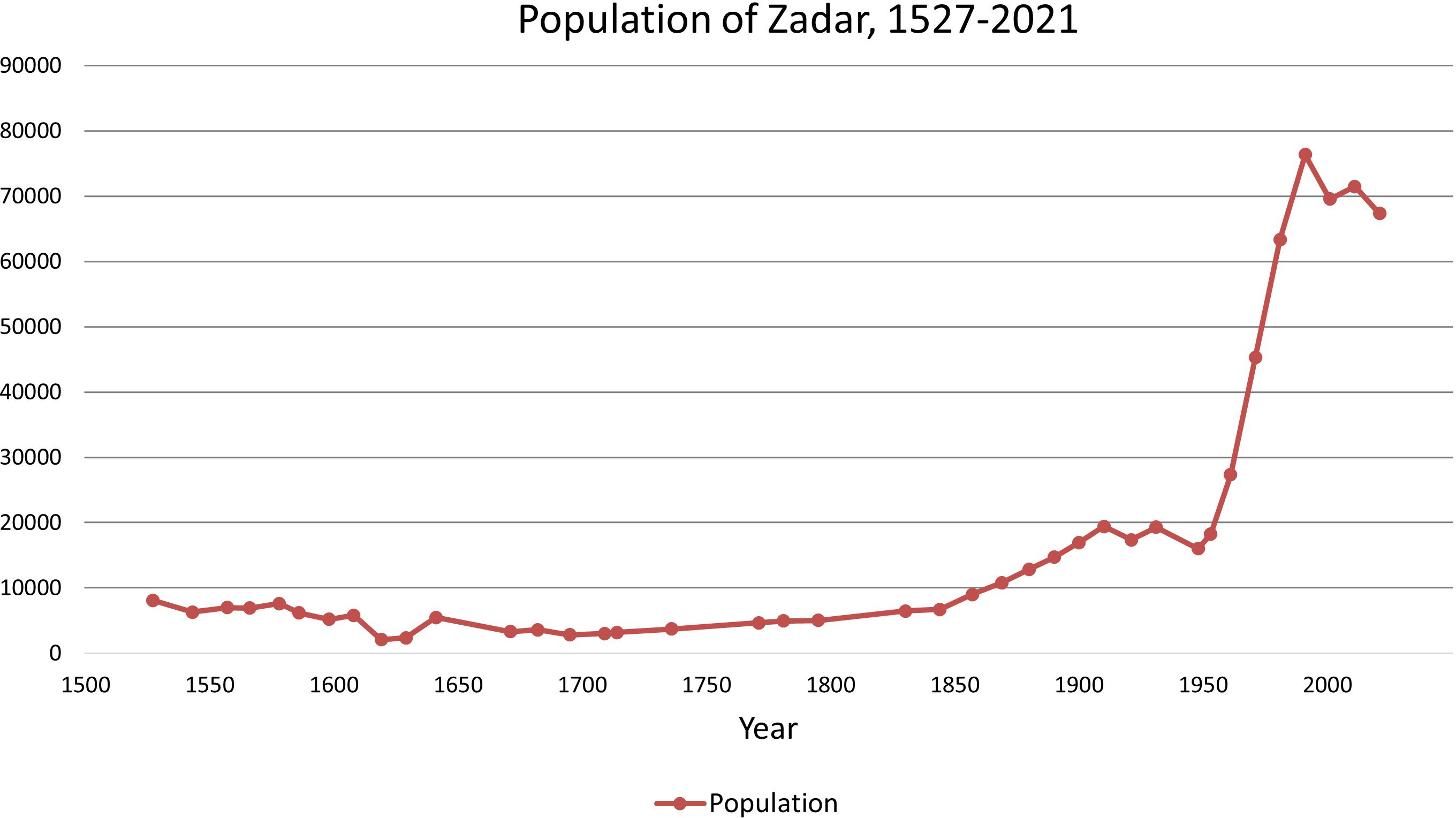
Figure 13 Population growth in Zadar, 1527 to 2021 (Blaće, 2015; Croatian Bureau of Statistics, 2022).
Data from the middle of the nineteenth century onward is more secure, as the Habsburg Monarchy conducted the first official population census in 1857. In the decades to follow, Zadar saw its population grow steadily to around 20,000 before experiencing a period of stagnation during the first and second world wars. Industrialization and modernization from the 1950s to 1980s expanded the labor market and drew more people from the neighboring islands and hinterland to settle and work in Zadar. In 1971, for example, 65% of Zadar’s population had migrated from other parts of Croatia and Yugoslavia (Magaš, 2009, 290). In the late twentieth century, Zadar experienced the largest demographic growth in its history, exceeding 70,000 in 1991 just before the Croatian War of Independence, and again in the 2011 census before registering a slight decline in 2021 (Croatian Bureau of Statistics, 2022). Focusing on the Modern Era only, Zadar experienced population growth rates of 49% during the period 1800–1850, 118% during the period 1850–1900, less than 1% decline during the period 1900–1950, and an unprecedented 315% growth from 1950–2000.
The preceding sections provide a high-level overview of changes in urban landcover and green space from Zadar’s emergence as an Iron Age settlement in the early first millennium BCE to a contemporary commercial and cultural center of the twenty-first century. Although the city’s persistence through time is important, its pace of change should also be a major factor when considering long-term resilience. For nearly three thousand years, from its Iron Age origins to the late nineteenth century, urban infrastructure was built, renovated, demolished, and built again, nearly entirely within the confines of its peninsular setting and often recycling construction material. Prior to the mid-twentieth century, the mainland terrain surrounding Zadar’s urban nucleus was predominantly agrarian in nature, with clear land use legacies stemming from Roman centuriation and other historic field clearance and management practices that generated drystone walls, terraces, and cairns. The persistence of this agrarian landscape into the twentieth century reflects its socioecological importance to Zadar’s historic urban core for millennia. However, the pace of economic change, demographic growth, and urban development since the mid-twentieth century represents a significant departure from Zadar’s 3,000-year trajectory. In light of the transforming city, we organize our discussion of Zadar around the pace of landcover change, the significance of historic green space to urban resilience in Zadar’s past and present, and the value of archaeological and historical approaches to urban resilience studies on the contemporary Mediterranean city.
The long, diachronic approach to urban resilience taken here provides an opportunity to better contextualize the contemporary pace of urban change against Zadar’s millennial-scale past. Estimates of areas under urban landcover are challenging for earlier periods given the incomplete archaeological record generated from (mostly) rescue operations around the city. However, using source data associated with Figure 2, we are able calculate urban landcover (ha) for select periods along the city’s historical trajectory (Table 1; see also Figure 2). Because of the potential for large margins of error, we also offer more conservative estimates to account for inconsistencies or gaps in archaeological knowledge, with a 50% increase to the calculations based on available information. According to these figures, the distribution of urban landcover versus historical green space appears to have been fairly stable for much of Zadar’s 3,000-year history, with urban landcover expanding slowly at an average rate of only 2–3 ha per century over the course of about 2,000 years, from the Late Iron Age (ca. 19–29 ha) to the early nineteenth century (ca. 60–90 ha). The growth of urban landcover then accelerated over the subsequent one hundred years, likely more than doubling to ca. 139–209 ha by the early to mid-twentieth century. To contextualize growth into the present era, these estimates are compared to more precise landcover data for the early twenty first century (Figure 14) (Geofabrik, 2018). When compared to 1944 calculations, Zadar’s urban landcover expanded at an unprecedented rate to cover 1,545 ha by the early twenty first century, a more than 1,000% increase based on our calculations, or a 640% increase if we use the more conservative 209 ha for the 1,944 estimate (see Table 1).
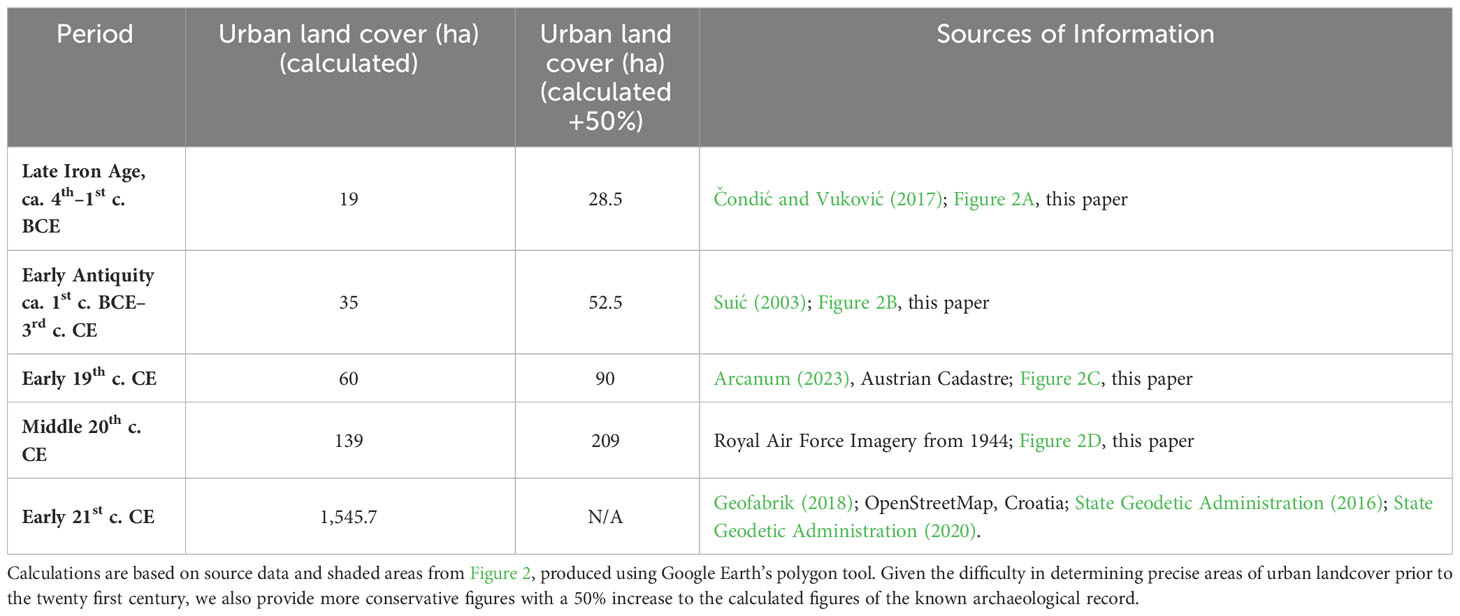
Table 1 Urban landcover from select periods, Iron Age to present.

Figure 14 Early twenty first century landcover around Zadar. Farmland and Orchard: 241.27 ha (4.64%); Grassland: 905.53 ha (17.41%); Forest and shrubs: 2474.41 ha (47.58%); Parks: 33.09 ha (0.64%); Urban/Residential/artificial/built-up: 1545.70 ha (29.73%) (State Geodetic Administration, 2016; Geofabrik, 2018; State Geodetic Administration, 2020).
Currently, the 1,545 ha of contemporary urban landcover (residential, commercial, industrial, roads) accounts for approximately 30% of Zadar’s settlement. Forest and scrub vegetation cover approximately 48%; grasslands and meadows cover 17%; farmland covers 4.5%; and parks less than 1% (calculated by the authors according to the State Geodetic Administration, 2020). Although these data indicate a large share of green space, its spatial distribution is uneven. Forests are primarily located at the northern and northwestern outskirts of Zadar and at some distance from residential spaces. In newer parts of Zadar (post-1950s), house lot gardens with olives, grapes, figs, citrus fruits, artichokes, leafy greens, and lavender are common, but given their small surface areas, their environmental impact is unclear. In many cases, their value appears to be in aesthetics (Mediterranean landscape) and cultural identity (traditional land use), both of which would enhance the health and well-being of resident populations while also potentially providing small subsistence or economic benefits.
During the city’s late twentieth century transformation, former agricultural green areas accommodated urban expansion beyond the peninsula, but the few surviving historic green spaces within Zadar’s urban landcover continue to be targeted first for development. Their loss highlights a related issue in that early cities often emerged in resource-rich or highly productive environments. In the case of Zadar, the reflections of Roman centuriation coupled with intensive networks of drystone walls, terraces, and cairns is indicative of long-term investment in a highly valued (agri)cultural landscape. As urban settlements persist through time and expand outward, urban landcover tends to displace valuable local farmland and other green spaces to less productive settings elsewhere. On a global scale, it has been estimated that urban expansion occurs on agricultural landscapes that are 1.77 times more productive than the global average (Bren d’Amour et al., 2017). Recent analyses have highlighted this problem from a slightly different angle by determining that indirect forest losses through cropland displacement far exceed direct losses through urban expansion. The result is that more land is required to achieve similar productivity to those lost to urban landcover (van Vliet et al., 2017; van Vliet, 2019).
The rapid transformation of Zadar’s agricultural landscape into urban landcover in the latter half of the twentieth century seems to conform to this pattern. During the 1960s and 1970s, Bokanjačko Blato, a wetland near Zadar, was developed for agricultural purposes, but the project would only become agriculturally viable after significant infrastructural investments. Surface canals and tunnels were first constructed near the sink hole to drain surface water, followed by a curtain injection on its western side to prevent or decrease the intrusion of underground seawater, a complicating factor in its cultivation (Ilijanić et al., 2018, 67). Although the project demonstrates the value Zadar continues to place on cultivated spaces in its immediate hinterland, the timing of this development corresponds to the period of rapid urban displacement of the millennia-old agrarian landscape that once surrounded the historic core of the city.
Twentieth century urban landcover expanded rapidly along a similar trajectory to Zadar’s population growth, yet a key difference lies in the fact that urban landcover does not contract in the same way that a city may experience periodic episodes of demographic decline, whether measured in permanent residential population or in seasonal tourists. The loss of green space due to urban expansion is essentially permanent, or at minimum, a much more costly and difficult endeavor to recover once it is lost. The unprecedented pace of urban landcover expansion around Zadar since the mid-twentieth century, as demonstrated through a millennial-scale lens, is quickly erasing a key part of its adaptive capacity since the city’s inception. The protection of such green spaces in urban and peri-urban contexts in the newly transformed city must therefore be carefully considered under the continued pressures of rapid urban development, as they have been (and remain) much more malleable in the face of change than the homogenized urban landcover that replaces them.
Historically, Zadar’s agricultural green spaces surrounding the urban nucleus have demonstrated their ability to persist and transform in the face of millennial scale change. From its earliest settlement in the Iron Age to Croatia’s membership into the European Union in 2013, Zadar has experienced periods of climatic stability and increased variability, fluctuations in temperature and precipitation, political stability and upheaval, war, population movement, and socioeconomic change. Although specific responses to events, disturbances, or trends on a millennial scale are not known, Zadar’s green space provided options and ensured the capacity to persist, transition, and transform over the course of the Late Holocene.
The evolution of Zadar’s sociopolitical landscape is clearly evident in the archaeological record and in the many fortifications, historic constructions, renovations, and new developments that reflect the locally distinctive character of its urban built environment. Over this same period, the green space surrounding Zadar persisted and transformed to meet the changing needs of the city. As a vegetated landscape, agricultural fields are dynamic and constantly evolving, despite the apparently static nature of centuriated grids, drystone walls, terraces, and other relatively fixed legacies of land use (Countryman et al., in press). Mixed agricultural spaces surrounding the city permitted the intensification or relaxation of production, along with changing emphases on diversified subsistence farming (e.g., mixed cereal agriculture) versus specialized market production (e.g., olive-focused arboriculture), as local and regional markets permitted. The agropastoral economy during the Middle Ages and Early Modern Era was flexible and diverse, with infields on the mainland dedicated to olive groves and vineyards while more distant fields were utilized for grain production. Livestock, wheat, and wine continued to be important products throughout Dalmatia, with a notable mix of subsistence and commercial products in the local inventory (i.e., mulberries, melons, figs, plums, and the marasca cherry). The mainland continued to be a resilient and diverse mosaic of green spaces during the Modern Era, with grasslands, plough fields, vineyards, groves, and vegetable gardens. During the nineteenth and twentieth century, in response to changes in the European market for wine (precipitated primarily by the adverse impacts of phylloxera on vines elsewhere in Europe), farmers intensified viticulture and wine production, before the disease eventually made its way to Croatia as well.
During the latter half of the twentieth century, as the economic role of agriculture declined during the era of industrialization, the surrounding green space provided adequate terrain for the development of new industrial, residential, and commercial sectors. Although it accommodated the city’s expansion during a period of rapid socioeconomic and demographic transformation, these historic green spaces quickly disappeared under new construction projects, representing a permanent loss of a key resource in the city’s adaptive capacity to future scenarios (see Kumagai et al., 2015, for a similar argument regarding Tokyo). Nevertheless, the last remaining historic green spaces, even in their diminished capacities, have the potential to build resilience for the contemporary city through their persistence as semi-wild parklands and protected “green” cultural heritage, or by transitioning into cultivated fields, urban gardens, recreational parks, or other green areas.
In their current forms, these surviving relics also have the capacity to mitigate uncertain challenges related to climate change in the twenty first century. Predictions for the city of Zadar indicate an increase in the daily mean temperature of 1.1 to 1.6°C and the prolongation of droughts from 6 to 37 days for the period 2021–2050 when compared to 1971–2000 (Državni hidrometeorološki zavod, 2020). This is likely to adversely impact water and energy consumption, particularly as it is expected to correspond to the already hot and dry summer months, but exacerbated further by seasonal population swells from tourist visits. In 2013, for example, water consumption in Zadar ranged from 500 to 600 l/s, while during the summer months it increased to 800 l/s (Razvojna agencija Zadarske županije, 2013). Moreover, the urban area of Zadar already resembles a heat island, with remote sensing data from 2013 indicating that average summer daytime maximum temperatures in Zadar were 2.5°C higher than in its surroundings (CIESIN, 2016). In addition to rising temperatures and increases in the frequency and duration of dry periods, the frequency and intensity of severe precipitation events are also expected to increase, leaving water channels and urban areas with impervious surfaces more vulnerable to severe flooding (ANT d.o.o, 2021, 45–46).
The vegetation cover and field architecture characteristic of Zadar’s historic green spaces, even in their dilapidated states, would provide ecosystem benefits by reducing surface flow and erosion during intense precipitation events and permitting greater infiltration to enhance soil moisture and water retention. Moreover, these vegetated spaces, along with urban forests, recreational parks, and house lot gardens (particularly those with olives, cherries, figs, vines, and other shade-throwing plants), have a localized cooling effect on the heat absorbing surfaces of the urban built environment. The Urban Heat Island (UHI) effect occurs among dense built-up spaces and impervious surfaces, which have higher heat capacities when compared to surrounding areas. In a study of microclimate regulation among 601 European cities, in which Zadar was included, urban green infrastructure was found to cool cityscapes by 1.07°C on average, with tree cover of at least 16% required to achieve a 1°C drop in urban temperatures (Marando et al., 2022). The study demonstrates the importance of trees in reducing UHI, with the extent of tree cover within the city identified to be an important variable. This has been documented in the north African Mediterranean city of Tunis as well, where city parks and trees were observed to have a cooling effect on urban temperatures, but noting also that the spatial influence of these green spaces diminishes with distance and no longer operates beyond about 700 m (Charfi et al., 2014, 73–74). The overgrown historical green spaces within Zadar’s cityscape likely impact the UHI in similar fashion to those documented elsewhere around Europe and the Mediterranean.
A report on the management plan for Zadar expounded upon the importance of green space in urban planning, not only for the historic city core but, importantly, within the expanding urban conglomerate on the mainland as well (Urbanex, 2016). Between the 1950s and 1991, managed green areas (i.e., city parks, recreational areas, and tree lines) in Zadar gradually increased from 32 to 72 ha, while at the same time the average green area per capita fell from 21.5 m2 to 9.6 m2 due to pronounced population growth over the same period (Magaš, 2009, 334). Zadar now has approximately 70 ha of managed green areas, which amounts to around 10 m2 per capita. This corresponds to the minimum recommended area by the World Health Organization (Russo and Cirella, 2018). Incorporating the unkept historic agricultural spaces into Zadar’s management plan alongside these other managed green areas would further strengthen the role of green space in building adaptive capacity for the coming century. Moreover, maintaining their scattered distribution throughout the city, rather than positioned only at the margins, would further strengthen urban resilience in the face of both temperature and precipitation uncertainties in the next century.
The importance of green space and green infrastructure in urban settings has prompted recent calls for its promotion and protection across the European Union (World Health Organization, 2017; European Commission, 2020). In the Mediterranean region, research over the past two decades has centered on the shared challenges related to the rapid pace of urban landcover expansion, landscape homogenization, and the loss of green space in the contemporary city (Salvati and Gargiulo Morelli, 2014). As the Mediterranean city transforms into a more dispersed form of urbanism, urban geographers have recognized that farmland is often the first landcover to be displaced, with other valuable forms of green space like forests, wetlands, and other semi-natural landcovers also transformed, impacting the city’s vulnerability and resilience (Bouraoui, 2003; Aguilar et al., 2006; Bouraoui and Vidal, 2008; Catalán et al., 2008; Salvati et al., 2012; Salvati et al., 2013; Díaz-Pacheco and García-Palomares, 2014; Tomao et al., 2017; Trentanovi et al., 2021; Quintas-Soriano et al., 2022; Valente et al., 2022). Recent work in Greece (Salvati et al., 2013) and Italy (Salvati et al., 2012) compared the impacts of compact urban growth vs. sprawl on landcover change from 1960 to the early 2000s in Attica and Rome, respectively. Both studies identified cropland as the most likely class of land use to be transformed into urban landcover during the phase of low-density sprawl. Interestingly, in Rome, low-density urban sprawl expanded onto not only a mix of lower valued arable lands, fallow fields, and abandoned farmland, but rather onto higher quality landcovers like pastures, vineyards, olive groves, and woodlands as well (Salvati et al., 2012, 51). A comparable study in Spain over a similar timeframe identified the loss of fertile soils to Alicante’s urban landcover to be a significant outcome during its late twentieth century low-density growth phase. Like Zadar, much of Alicante’s transformation is now characterized by tourist and residential infrastructure (Aguilar et al., 2006).
Other notable studies explicitly argue the importance of agricultural green space in the contemporary city. Among North African cities of the Maghreb, for instance, Bouraoui (2003, 52) suggests that maintaining and integrating cultivated fields into the Tunisian capital would improve the amount of green space per capita while also enriching the urban landscape (as determined, in part, by public opinion). In a subsequent study, Bouraoui and Vidal (2008) go a step further to make a case for agricultural spaces as active elements of the urban environment, clarifying also that the point is not simply to feed the city’s residents, but rather to create a more livable and adaptable city. Unfortunately, as has been noted elsewhere, agricultural land use can only resist urban landcover expansion so long as it is economically competitive or protected space (Catalán et al., 2008, 180). In the twenty first century Mediterranean city, the challenge to manage and protect green space as a way to build adaptive capacity will likely intensify as urban landcover pressures continue.
Although these studies on the contemporary Mediterranean city and green space are tremendously valuable, few of them incorporate archaeological or deeper historical perspectives, focusing instead on the past few decades or half century at most. The approach we espouse integrates archaeological and historical studies to provide long-term context to landcover change in the contemporary era, and, importantly, as a way to characterize the cultural and historical importance of green spaces lost to or threatened by urban transformation. In this sense, archaeology can play a role in identifying not only past strategies of land use and resilience, but also in generating ideas and possibilities that may help to shape the future (Turner et al., 2020, 598). In Zadar, these green spaces were predominantly agricultural in nature and contributed to the city’s resilience for more than two millennia. The surviving relicts may, even in their dilapidated states, continue to build capacity toward a resilient twenty first century city, but they are currently undervalued and usually the first to be targeted for continued urban development. Prior to the mid twentieth century, the managed agricultural landscape surrounding the city, complete with its extensive array of drystone walls draped over the more ancient centuriated grid, was an important feature of the cultural landscape. Its legacy, embedded in the surviving green spaces within and beyond the city’s urban landcover, may contribute significantly to the protection of Zadar’s local distinctiveness in spaces beyond the peninsular urban built environment. Historic urban nuclei around the Mediterranean usually retain some element of local distinctiveness through historic preservation and conservation measures, but low-density sprawl beyond these historic centers transitions into a homogenous array of residential, commercial, and industrial landcover. Recognition of this point may offer additional value for the protection and conservation of historic green spaces in the twenty first century city. Their persistence would help to not only build adaptive capacity toward an uncertain climate future, but also safeguard the city’s local distinctiveness and cultural identity beyond the historic urban nucleus, resist further homogenization, and enhance landscape diversity. It would also serve to differentiate the low-density urban landscape of Zadar from others in the Mediterranean region. This strategy may benefit other historical cities, where urban geographers, planners, policymakers, and community members are often faced with similar challenges resulting from low-density sprawl, the loss of green space, and by extension, the loss of a resilient, locally distinctive cultural landscape.
Legacies from Roman centuriation and historic field clearance practices around Zadar represent some of the most distinctive and well-preserved physical manifestations of ancient and historic land use in the Mediterranean. Our treatment of this distinctive cultural landscape as green space draws the historic and more ancient past into a single framework with the present to address urban resilience and socioecological systems in the twenty first century. The deep, historical approach employed here serves to identify elements of the cultural landscape that facilitated and supported a city’s capacity to persist and transform in the face of changing climatic, sociopolitical, and economic circumstances. Yet, the pace at which former (agri) cultural green space has been lost to urban landcover over recent decades represents a major departure from its long-term trajectory and is quickly depleting a major source of resilience that has benefitted the city since the Iron Age. Only when Zadar’s contemporary growth is projected against the city’s millennial scale past does the unprecedented pace of change, and severity of the challenge, come into focus.
The recognition of local distinctiveness in green spaces may elevate their importance and cultural value within the contemporary Mediterranean city. Their persistence would thus help to not only safeguard an important part of the city’s culturally distinctive identity beyond the historic urban nucleus, but also to build adaptive capacity for a resilient Mediterranean city in an uncertain climate future.
The original contributions presented in the study are included in the article/supplementary material; further inquiries can be directed to the corresponding author/s.
GZ designed the research and drafted the introduction, materials and methods, and initial framework for the results. AB drafted portions of the results. GZ and AB drafted the discussion and conclusion, and they organized figures/tables. JBP, MČ, FJP, and KG drafted significant portions of the results. All authors made substantial editorial contributions to the final manuscript. All authors contributed to the article and approved the submitted version.
We thank the editors for inviting us to contribute to this research topic and the reviewers for their helpful comments and insight. We are also grateful to the University of Zadar and to the University of Maine for their support of this work.
The authors declare that the research was conducted in the absence of any commercial or financial relationships that could be construed as a potential conflict of interest.
All claims expressed in this article are solely those of the authors and do not necessarily represent those of their affiliated organizations, or those of the publisher, the editors and the reviewers. Any product that may be evaluated in this article, or claim that may be made by its manufacturer, is not guaranteed or endorsed by the publisher.
Aguilar J. P., Carlos Añó V. A., Sánchez J. (2006). “Urban growth dynamics, (1956–1998) in Mediterranean coastal regions: The case of Alicante, Spain,” in Desertification in the Mediterranean Region, A security issue, vol. 3. Eds. Kepner W. G., Rubio J. L., Mouat D. A., Pedrazzini F. (Dordrecht: Springer), 325–340.
Alihodžić T. (2009). “Zadar – Polačišće i Ulica Petra Svačića,” Hrvatski arheološki godišnjak 5/2008, 508–509.
Andlar G., Šrajer F., Trojanović A. (2017). Classifying the Mediterranean terraced landscape: The case of Adriatic Croatia. Acta Geographica Slovenica 57 (2), 111–129. doi: 10.3986/AGS.4673
Andlar G., Šrajer F., Trojanović A. (2018). Discovering cultural landscape in Croatia: History and classification of Croatian Adriatic Enclosed Landscape. Annales: Ser. Hist. Sociologia 28 (4), 759–778.
ANT d.o.o (2021). Akcijski plan provedbe prirodnih rješenja u prilagodbi klimatskim promjenama na području Grada Zadra (Nature Based Solutions Action Plan for City of Zadar) (Zagreb: Administrative Department for Communal Activities and Environmental Protection). Report submitted to the City of Zadar, ANT d.o.o.
Anzulović I. (2010). “Najstariji poznati spomen stabla višnje maraske u Zadru i na njegovom području,” in Višnja maraska: Bogatstvo Zadra i zadarske regije. Eds. Bralić A., Faričić J. (Sveučilište u Zadru, Maraska d.d., Zavod za povijesne znanosti Hrvatske akademije znanosti i umjetnosti u Zadru, Zadar), 107–117.
Aplin G. (2007). World heritage cultural landscapes. Int. J. Heritage Stud. 13 (6), 427–446. doi: 10.1080/13527250701570515
Arcanum (2023). Habsburg Empire - Cadastral Maps (XIX. century). Available at: https://maps.arcanum.com/en/ (Accessed March 17, 2023).
Archaeoglobe Project (2019). Archaeological assessment reveals Earth’s early transformation through land use. Science 365, 897–902. doi: 10.1126/science.aax119
Atiqul Haq S. M., Islam M. N., Siddhanta A., Ahmed K. J., Chowdhury M. T. A. (2021). Public perceptions of urban green spaces: Convergences and divergences. Front. Sustain. Cities 3. doi: 10.3389/frsc.2021.755313
Barthel S., Isendahl C. (2013). Urban gardens, agriculture, and water management: Sources of resilience for long-term food security in cities. Ecol. Economics 86, 224–234. doi: 10.1016/j.ecolecon.2012.06.018
Barthel S., Parker J., Ernstson H. (2015). Food and green space in cities: A resilience lens on gardens and urban environmental movements. Urban Stud. 52 (7), 1321–1338. doi: 10.1177/0042098012472744
Batović Š. (1964). “Zadar u prethistoriji,” in Zadar – Zbornik: geografija, ekonomija, saobraćaj, povijest, kultura. Ed. Ravlić J. (Zagreb: Matica hrvatska), 105–116.
Batović Š. (1965). “Die Eisenzeit auf dem Gebiet des illyrischen Stammes der Liburner,” in Archeologia Iugoslavica, VI, 55–70.
Batović Š. (1977). Caractéristiques des agglomérations fortifiées dans la region des Liburniens. Godišnjak Centra za balkanološka ispitivanja 13/XV, 201–225.
Batović Š. (1983). “Kasno brončano doba na istočnom Jadranskom primorju,” in Praistorija Jugoslavenskih Zemalja IV - Brončano Doba. Eds. Benac A., Čović B. (Sarajevo), 271–373.
Batović Š. (1987). “Liburnska grupa,” in Praistorija jugoslavenskih zemalja V – Željezno doba. Eds. Benac A., Gabrovec S. (Sarajevo), 339–390. Sarajevo: Akademija nauka i umjetnosti Bosne i Hercegovine.
Begović V., Schrunk I. (2002). Rimske vile Istre i Dalmacije, I. dio: Pregled lokaliteta. Prilozi Instituta za Arheologiju u Zagrebu 19, 113–130.
Bekić L., Vrkić Š., Pešić M., Surić R. (2017). Sveti Nikola u Zadru: arheološka iskopavanja u samostanskom sklopu sv. Nikola u Zadru 2014. –2016., 1. dio (Zadar: Međunarodni centar za podvodnu arheologiju).
Blaće A. (2015). Razvoj i suvremena preobrazba krajolika Ravnih kotara (Zagreb, Croatia: University of Zagreb). [dissertation].
Blečić Kavur M., Podrug E. (2014). The necropolis at the Velika Mrdakovica Hillfort – Early Iron Age graves. Vjesnik za arheologiju i historiju dalmatinsku 107, 31–112.
Boatwright M. T., Gargola D. J., Lenski N., Talbert R. J. A. (2012). The Romans: From Village To Empire. 2nd ed. (New York: Oxford University Press).
Bolund P., Hunhammar S. (1999). Ecosystem services in urban areas. Ecol. Economics 29, 293–301. doi: 10.1016/S0921-8009(99)00013-0
Bouraoui M. (2003). L’agriculture urbaine en Tunisie: Espace relictuel ou nouvelle composante territorial? Le cas du Grand Tunis / Urban agriculture in Tunisia: Residual space or a new territorial component? The case of greater Tunis. Rev. Géographie Alpine 91 (4), 43–54. doi: 10.3406/rga.2003.2261
Bouraoui M., Vidal R. (2008). “What are the perspectives for open spaces in urbanization projects touching the large cities of the Maghreb? Comparative approach between Grand Tunis and the Sousse coast,” in La Croissance de la Ville Maghrébine à travers les âges (Tunis: Actes du colloque de I’AIMS).
Bradford J. (1947). A technique for the study of centuriation. Antiquity 21 (84), 197–204. doi: 10.1017/S0003598X00016689
Bradford J. (1957). Ancient Landscapes: Studies In Field Archaeology (London: G. Bell and Sons, LTD).
Braubach M., Egorov A., Mudu P., Wolf T., Ward Thompson C., Martuzzi M. (2017). Effects of Urban Green Space on Environmental Health, Equity and Resilience. In: Kabisch N., Korn H., Stadler J., Bonn A. (eds) Nature-Based Solutions to Climate Change Adaptation in Urban Areas. Theory and Practice of Urban Sustainability Transitions. (Cham: Springer). doi: 10.1007/978-3-319-56091-5_11
Bren d’Amour C., Reitsma F., Baiocchi G., Barthel S., Güneralp B., Erb K.-H., et al. (2017). Future urban land expansion and implications for global croplands. PNAS 114 (34), 89–39-8944. doi: 10.1073/pnas.1606036114
Brigand R. (2009). Nuove prospettive nello studio delle centuriazioni romane per carto e foto – interpretazione. Esempi veneti e istriani. Archeologia Aerea IV, 77–82.
Brkić-Vejmelka J. (2009). “Neki pogledi na turistički razvoj Zadra i okolice u drugoj polovici 20. st,” in Zadar i okolica od Drugoga svjetskog rata do Domovinskog rata. Ed. Oršolić T., 464–485. Zadar: Hrvatska akademija znanosti i umjetnosti, Zavod za povijesne znanosti.
Brusić Z. (2001). “Rezultati prapovijesnih istraživanja na Relji u sklopu izgradnje Trgovinskog centra,” in Iskoni be slovo, Zbornik radova o glagoljici, glagoljašima zadarskog kraja i crkvi Svetoga Ivana Krstitelja. Ed. Badurina A. (Zagreb: Provincijalat franjevaca trećoredaca, Kršćanska sadašnjost), 45–49.
Büntgen U., Tegel W., Nicolussi K., McCormick M., Frank D., Trouet V., et al. (2011). 2500 years of European climate variability and human susceptibility. Science 331, 578–582. doi: 10.1126/science.1197175
Čače S. (2006). “South liburnia at the beginning of the principate: jurisdiction and territorial organization,” in Les routes de l'Adriatique antique. Géographie et économie. Eds. Čače S., Kurilić A., Tassaux F. (Bordeaux: Institut Ausonius, Zadar: Universitè de Zadar), 65–79.
Campbell B. (2000). The Writings of the Roman Land Surveyors: Introduction, Text, Translation, and Commentary. Society for the promotion of Roman studies. J. Roman Stud. Monograph No. 9, London.
Catalán B., Saurí D., Serra P. (2008). Urban sprawl in the Mediterranean? Patterns of growth and change in the Barcelona Metropolitan Region 1993-2000. Landscape Urban Plann. 85, 174–184. doi: 10.1016/j.landurbplan.2007.11.004
Čelhar M. (2014). Naselja Južne Liburnije u Željezno doba (Settlements in Southern Liburnia in the Iron Age), PhD thesis, University of Zadar, Department of Archaeology, Zadar.
Cesarsko kraljevska središnja statistička komisija (1908). Općinski rječnik za kraljevine i zemlje zastupane u Carevinskom vijeću, XIV (Dalmacija).
Charfi S., Krout H., Dahech S. (2014). Vegetation in the urban area of Tunis: A study of impacts on temperature and light. Climatologie 11, 72–78. doi: 10.4267/climatologie.534
Christensen J. H., Christensen O. B. (2003). Climate modelling: Severe summertime flooding in Europe. Nature 421 (6925), 805–806.
CIESIN (2016). Documentation for the global urban heat island (UHI) data se (New York: Center for International Earth Science Information Network – Columbia University). Available at: https://sedac.ciesin.columbia.edu/data/set/sdei-global-uhi-2013/metadata.
Čondić N. (2010). Liburnski grobovi na zadarskom poluotoku / Liburnian graves in Zadar (on the Peninsula). Diadora 24, 27–55.
Čondić N., Vuković M. (2017). “U temeljima grada: Iz arheoloških slojeva liburnskoga Zadra / In the City’s Foundations: The Archaeological Layers of Liburnian Zadar,” in Katalozi i monografije 27 (Arheološki Muzej Zadar).
Countryman J., Zaro G., Blaće A., Čelhar M. (In Press). “Feral fields of Northern Dalmatia (Croatia)”, in Finding Fields: The Archaeology of Agricultural Landscapes. Eds. McLeester M., Casana J.. Archaeological Papers of the American Anthropological Association (AP3A) Series. Arlington, VA: American Anthropological Association.
Croatian Bureau of Statistics (2021). Tourism 2020. Statistical report 1683. Available at: https://podaci.dzs.hr/media/egclbob1/si-1683_turizam-u-2020_web.pdf.
Croatian Bureau of Statistics (2022). Census of population, households and dwellings in 2021 - population by settlements. Available at: https://podaci.dzs.hr/hr/podaci/stanovnistvo/popis-stanovnistva/.
Čuka A., Graovac Matassi V., Lončar N. (2012). Historijsko-geografske promjene u društveno-gospodarskom vrjednovanju ruralnih prostora Ravnih Kotara – primjer Nadinskog područja (Hrvatska). Annales – Ser. Hist. Social. 22, 157–170.
Čuka A., Mirošević L., Faričić J., Graovac Matassi V. (2017). Phylloxera revisited: the spread of grapevine disease in Dalmatia and its influence on socio-economic development and agricultural landscape. Annales – Ser. Hist. Social. 27:1, 101–118. doi: 10.19233/ASHS.2017.09
Davis P. (2005). “Places, ‘cultural touchstones’ and the ecomuseum,” in Heritage, Museums and Galleries: An Introductory Reader. Ed. Corsane G. (London and New York: Routledge, Taylor and Francis Group), 402–415.
Díaz-Pacheco J., García-Palomares J. C. (2014). Urban sprawl in the Mediterranean urban regions in Europe and the crisis effect on the urban land development: Madrid as study case. Urban Stud. Res. 2014. doi: 10.1155/2014/807381
Državni hidrometeorološki zavod (2020). Procjena klimatskih promjena u budućnosti za grad Zadar (Zagreb: Državni Hidrometeorološki Zavod).
Ellis E. C., Gauthier N., Goldewijk K. K., Bird R. B., Boivin N., Díaz S., et al. (2021). People have shaped most of terrestrial nature for at least 12,000 years. PNAS 118 (17), e2023483118. doi: 10.1073/pnas.2023483118
European Commission (2020). EU Biodiversity Strategy for 2030: Bringing nature back into our lives (Brussels, Belgium: Communication from the Commission to the European Parliament, the Council, the European Economic and Social Committee, and the Committee of the Regions).
European Environment Agency (2016). European Digital Elevation Model (EU-DEM), version 1.1. Available at: https://land.copernicus.eu/imagery-in-situ/eu-dem/eu-dem-v1.1?tab=download (Accessed March 15, 2023).
European Environment Agency (2018). Europe’s seas. In: Geodatabase. Available at: https://www.eea.europa.eu/data-and-maps/data/europe-seas-2 (Accessed April 15, 2023).
Fadić I. (1986). Diklo kod Zadra. Villa rustica. Arheološki pregled (Archaeological Reports). 1985, 90–91.
Fadić I., Štefanac B. (2011). Geneza grada na Trgu Petra Zoranića u Zadru. Histria antiqua 20, 325–332.
Farkas J. Z., Hoyk E., Batista de Morais M., Csomós G. (2023). A systematic review of urban green space research over the last 30 years: A bibliometric analysis. Heliyon 9, e13406. doi: 10.1016/j.heliyon.2023.e13406
Finné M., Holmgren K., Sundqvist H. S., Weiberg E., Lindblom M. (2011). Climate in the eastern Mediterranean, and adjacent regions, during the past 6000 years—a review. J. Archaeological Sci. 38, 3153–3173. doi: 10.1016/j.jas.2011.05.007
Forenbaher S. (1999). The earliest islanders of the Eastern Adriatic. Collegium Antropologicum 23 (2), 521–530.
Forenbaher S. (Ed.) (2009). A Connecting Sea: Maritime Interaction in Adriatic Prehistory (Oxford, UK: British Archaeological Reports International Series).
Geofabrik (2018). OpenStreetMap data for Croatia. Available at: http://download.geofabrik.de/europe/Croatia.html (Accessed March 16, 2023).
Giorgi F., Lionello P. (2008). Climate change projections for the Mediterranean region. Global Planetary Change 63, 90–104. doi: 10.1016/j.gloplacha.2007.09.005
Gluščević S. (2005). Zadarske nekropole od 1. do 4. stoljeća, Organizacija groblja, pogrebni obredi, podrijetlo, kultura, status i standard pokojnika (Zadar: University of Zadar, Department of Archaeology).
Graovac V. (2014). “Contemporary urban changes in Croatia – The case study of Zadar,” in Critical Spaces – Contemporary Perspectives in Urban, Spatial, and Landscape Studies. Ed. Calcatinge A. (Zurich: Lit Verlag GmbH & Co. KG Wien), 167–178.
Grimm N. B., Faeth S. H., Golubiewski N. E., Redman C. L., Wu J., Bai X., et al. (2008). Global change and the ecology of cities. Science 319, 756–760. doi: 10.1126/science.1150195
Grüger E. (1996). “Vegetational change,” in The Changing Face of Dalmatia, Archaeological and Ecological Studies in a Mediterranean Landscape. Eds. Chapman J., Shiel R., Batović Š. (London: Leicester University Press), 33–43.
Gusar K., Vujević D. (2010). “Numizmatički nalazi s lokaliteta Jazine-Lignum u Zadru,” in INCC 2010: zbornik radova 6. međunarodnoga numizmatičkog kongresa u Hrvatskoj. Ed. Dobrinić J. (Rijeka: Hrvatsko numizmatičko duštvo), 113–126.
Gusar K., Vujević D. (2023). Crkva sv. Dominika u Zadru: Rezultati Arheoloških Istraživanja (Zadar: Sveučilište u Zadru, (in press).
Håkansson N. T., Widgren M. (Eds.) (2014). Landesque Capital: The Historical Ecology of Enduring Landscape Modifications (Walnut Creek, CA: Left Coast Press).
Hughes J. D. (2005). The Mediterranean: An Environmental History (Santa Barbara, CA: ABC-CLIO Press).
Ilakovac B. (1997). Rekonstrukcija rimskog tijeska za masline u mulinama na otoku Ugljanu. Radovi Zavoda povijesni znanosti HAZU Zadru 40, 1–26.
Ilijanić N., Miko S., Hasan O., Bakrač K. (2018). Holocene environmental record from lake sediments in the Bokanjačko blato karst polje (Dalmatia, Croatia). Quaternary Int. 494, 66–79. doi: 10.1016/j.quaint.2018.01.037
IPCC (2022). “Summary for policymakers,” in Climate Change 2022: Impacts, Adaptation, and Vulnerability. Eds. Pörtner H.-O., Roberts D. C., Tignor M., Poloczanska E. S., Mintenbeck K., Alegría A., et al. (Cambridge, UK and New York, NY, USA: Cambridge University Press), 3–33. doi: 10.1017/9781009325844.001
Isenhour C., McDonogh G., Checker M. (Eds.) (2015). Sustainability in the Global City (New York: Cambridge University Press).
Jakšić N. (1986). Draga sv. Krševana u Diklu (o tisućljetnoj obljetnici osnutka samostana). Radovi Filozofskog fakulteta u Zadru 25 (12), 205–229.
Jović Gazić V. (2011). Urban development from Late Antiquity to the Middle Ages: Dubrovnik, Split, Trogir, Zadar – the state of research. Archaeologia Adriatica V, 151–196.
Jurić R. (2002). Novija istraživanja srednjovjekovnih groblja na zadarskom području. Histria Antiqua 8, 295–312.
Jurjević M. (2020). Topografija rimske ruralne arhitekture na području južne Liburnije (Zadar: University of Zadar, Department of Archaeology).
Jurković Pešić F., Grgurić M. (2022). Rimska vila na Banskoj punti u Bibinjama, Bibinje. Eds. Bralić A., Gverić A. (Zadar: Sveučilište u Zadru, Općina Bibinje, Ogranak Matice hrvatske u Zadru), 128–139.
Kadi M. (2016). The Centuriation of the Island of Ugljan: The Roman Land Division (Zadar: University of Zadar).
Kadi M. (2020). Centuriation of continental part of Iader (Zadar) Roman colony ager, Roman cadastre. Kartografija i Geoinformacije 33 (19), 106–111.
Kingsley M. (2019). Climate change, health, and green space co-benefits. Health Promotion Chronic Dis. Prev. Canada – Research Policy Pract. 39 (4), 131–135. doi: 10.24095/hpcdp.39.4.04
Klaić N., Petricioli I. (1976). Zadar u srednjem vijeku do 1409. Prošlost Zadra II (Zadar: Filozofski fakultet Zadar, Narodni list).
Knežić D. (2022). Arheobotanička analiza slojeva liburnskog naselja u Nadinu (Zadar: University of Zadar, Department of Archaeology).
Krce Miočić B., Magaš D., Bacalja R., Razović M., Vidić G., Klarin T. (2016). Strategija razvoja turizma Grada Zadra za razdoblje 2016.–2026. godine (Zadar: Turistička zajednica Grada Zadar).
Kukoč S., Čelhar M. (2019). Nadin (Nedinum): Prostorna koncepcija nekropole kod Liburna /Nadin (Nedinum): Spatial concept of the Liburnian necropolis. Vjesnik za arheologiju i historiju dalmatinsku 112, 9–31.
Kumagai Y., Gibson R. B., Filion P. (2015). Evaluating long-term resilience through an examination of the history of green spaces in Tokyo. Local Environ. 20 (9), 1018–1039. doi: 10.1080/13549839.2014.887060
Lisec A., Navratil G. (2014). The Austrian land cadastre: From the earliest beginnings to the modern land information system. Geodetski Vestnik 58 (3), 482–516. doi: 10.15292/geodetski-vestnik.2014.03.482-516
Lončar N., Bar-Matthews M., Ayalon A., Faivre S., Surić M. (2019). Holocene climate conditions in the eastern Adriatic recorded in stalagmites from Strašna peć Cave (Croatia). Quaternary Int. 508, 90–106. doi: 10.1016/j.quaint.2018.11.006
Luterbacher J., Werner J. P., Smerdon J. E., Fernández-Donado L., González-Rouco F. J., Barriopedro D., et al. (2016). European summer temperatures since Roman times. Environ. Res. Lett. 11, 024001. doi: 10.1088/1748-9326/11/2/024001
Magaš D. (2009). “Prostorni razvoj Zadra 1945. – 1991,” in Zadar I Okolica Od Drugoga Svjetskog Rata Do Domovinskog Rata. Ed. Oršolić T. (Zadar: Hrvatska akademija znanosti i umjetnosti, Zavod za povijesne znanosti), 274–347.
Makhzoumi J., Pungetti G. (2008). “Landscape strategies,” in Mediterranean Island Landscapes. Eds. Vogiatzakis I., Pungetti G., Mannion A.M. (Dordrecht: Springer), 325–348.
Marando F., Heris M. P., Zulian G., Udías A., Mentaschi L., Chrysoulakis N., et al. (2022). Urban heat island mitigation by green infrastructure in European Functional Urban Areas. Sustain. Cities Soc. 77, 1–15. doi: 10.1016/j.scs.2021.103564
Maršić D. (1993). Prilog poznavanju limitacija agera antičkog Zadra. Radovi filozofskog fakulteta u Zadru 32 (19), 105–116.
Maurin D. (2012). Zadar – plinovodni sustav (Benkovačka cesta, Gaženička cesta). Hrvatski Arheološki Godišnjak 8/2011, 568–570.
Maurin D., Paraman L. (2013). Zadar - ulica fra ivana zadranina. Hrvatski Arheološki Godišnjak 9/2012, 647–650.
Mayhew T. (2008). Dalmatia between Ottoman and Venetian Rule: Contado di Zadar, 1645-1718 (Rome: Viella).
McCormick M., Büntgen U., Cane M. A., Cook E. R., Harper K., Huybers P., et al. (2012). Climate change during and after the Roman Empire: Reconstructing the past from scientific and historical evidence. J. Interdiscip. History XLIII (2), 169–220. doi: 10.1162/JINH_a_00379
Meerow S., Newell J. P., Stults M. (2016). Defining urban resilience: A review. Landscape Urban Plann. 147, 38–49. doi: 10.1016/j.landurbplan.2015.11.011
Mišković A. (2020). Grad i obred: zadarska svetišta i njihova liturgija od 5. do 11. stoljeća (Zadar: Sveučilište u Zadru).
Mlikota A. (2021). Zadar – Obnova i izgradnja nakon razaranja u Drugome svjetskom ratu (Zagreb: Školska Knjiga).
NASA (2023). NASA Sea level projection tool, based on IPCC 6th Assessment Report on Sea Level Projections. Available at: https://sealevel.nasa.gov/ipcc-ar6-sea-level-projection-tool (Accessed June 13, 2023).
Navratil G., Frank A. U. (2004). Processes in a cadastre. Computers Environment Urban Syst. 28, 471–486. doi: 10.1016/j.compenvurbsys.2003.11.003
Navratil G., Hafner J., Jilin D. (2010). Accuracy determination for the Austrian digital cadastral map (DKM). Fourth Croatian Congress Cadastre, 171–181.
Njegač D., Toskić A. (1999). Rural diversification and socio-economic transformation in Croatia. GeoJournal 46, 263–269. doi: 10.1023/A:1006976704796
Nye S. (1996). “The plant remains,” in The Changing Face of Dalmatia, Archaeological and Ecological Studies in a Mediterranean Landscape. Eds. Chapman J., Shiel R. (London: Leicester University Press), 240–242.
Palet J. M., Orengo H. A. (2011). The Roman centuriated landscape: Conception, genesis, and development as inferred from the Ager Tarraconensis case. Am. J. Archaeology 115 (3), 383–402. doi: 10.3764/aja.115.3.0383
Papayannis T., Sorotou A. (2008). “Cultural landscapes of Mediterranean islands,” in Mediterranean Island Landscapes. Eds. Vogiatzakis I., Pungetti G., Mannion A. M. (Dordrecht: Springer), 82–99.
Parica M. (2021). Prapovijesne maritimne konstrukcije Dalmacije i Kvarnera / Prehistoric maritime structures in Dalmatia and Kvarner (Zadar: Sveučilište u Zadru).
Peričić Š. (1999). Razvitak Gospodarstva Zadra i okolice u prošlosti. Hrvatska Akademija Znanosti i Umjetnosti. Zavod za povijesne znanosti HAZU (Zagreb – Zadar)
Peričić Š. (2011). “Povijest Zadra u XIX. stoljeću,” in Zadar za austrijske uprave, Prošlost Zadra, vol. IV . Ed. Batović Š. (Zadar: Matica Hrvatska – Ogranak Zadar), 13–257.
Perović Š., Fadić I. (2009). Zaštitno arheološko istraživanje dijela antičke nekropole Zadra u Zrinsko-Frankopanskoj ulici (Archaeological rescue excavations of part of the Roman necropolis of Zadar in Zrinsko-Frankopanska street). Diadora 23/2009, 45–130.
Pešić M. (2017). Istraživanja antičke luke Barbir u Sukošanu (Excavations at the antiquity period harbour at the Barbir site in Sukošan). Potopljena baština (Submerged heritage) 7, 28–32.
Petricioli I. (1958). Maketa Zadra u Pomorskom muzeju Venecije. Zbornik Instituta za historijske nauke u Zadru II, vol. 1956–1957, 101–124.
Petricioli I. (1965b). Novi rezultati u istraživanju zadarskih srednjovjekovnih fortifikacija. Diadora 3, 169–203.
Quintas-Soriano C., Buerkert A., Plieninger T. (2022). Effects of land abandonment on nature contributions to people and good quality of life components in the Mediterranean region: A review. Land Use Policy 116. doi: 10.1016/j.landusepol.2022.106053
Raukar T. (1977). Zadar u XV stoljeću, ekonomski razvoj i društveni odnosi, Sveučilište u Zagrebu (Zagreb: Institut za hrvatsku povijest).
Raukar T., Petricioli I., Švelec F., Peričić Š. (1987). Zadar pod mletačkom upravom: 1409-1797. Prošlost Zadra III (Zadar: Filozofski fakultet Zadar, Narodni list).
Razvojna agencija Zadarske županije (2013). Strategija razvoja grada Zadra 2013-2020 (Zadar). Report made available at: https://www.zadra.hr/images/dokumenti/izradeni_strateski_dokunmenti/14.pdf.
Rodwell D. (2007). Conservation and Sustainability in Historic Cities (Malden, MA: Blackwell Publishing).
Roselaar S. T. (2010). Public Land in the Roman Republic: A Social and Economic History of Ager Publicus in Italy, 396-89 BC (Oxford: Oxford University Press).
Rukavina M., Obad Šćitaroci M. (2017). Urban integration of archaeological heritage in Zadar. Annales: Ser. Hist. Sociologia 27 (2), 329–348.
Russo A., Cirella G. T. (2018). Modern compact cities: how much greenery do we need? Int. J. Environ. Res. Public Health 15 (10), 2180 doi: 10.3390/ijerph15102180
Saaroni H., Amorim J. H., Hiemstra J. A., Pearlmutter D. (2018). Urban Green Infrastructure as a tool for urban heat mitigation: Survey of research methodologies and findings across different climatic regions. Urban Climate 24, 94–110. doi: 10.1016/j.uclim.2018.02.001
Salvati L., Gargiulo Morelli V. (2014). Unveiling urban sprawl in the Mediterranean region: Towards a latent urban transformation? Int. J. Urban Regional Res. 38 (6), 1935–1953. doi: 10.1111/1468-2427.12135
Salvati L., Munafo M., Gargiulo Morelli V., Sabbi A. (2012). Low-density settlements and land use changes in a Mediterranean urban region. Landscape Urban Plann. 105, 43–52. doi: 10.1016/j.landurbplan.2011.11.020
Salvati L., Sateriano A., Bajocco S. (2013). To grow or to sprawl? Land cover relationships in a Mediterranean city region and implications for land use management. Cities 30, 113–121. doi: 10.1016/j.cities.2012.01.007
Serventi Z. (2014). Nekropole Rimske Liburnije: Aspekti društvene i religijske povijesti. (PhD Thesis. Zadar: University of Zadar).
Serventi Z., Jurjević M. (2012). Odnos nekropola i naselja u rimskodobnoj Liburniji (The relation between necropolises and settlements in Roman Liburnia). Prilozi instituta za arheologiju u Zagrebu 29, 195–214.
Smiljanić F. (2010). Jesu li komunalne utvrde – stražice na zadarskom komunalnom kopnenom posjedu doista kasnoantičke? Vjesnik Arheološkog muzeja u Zagrebu 43, 399–413.
Smith M. E. (2023). Urban success and urban adaptation over the long run. Open Archaeology 9, 20220285. doi: 10.1515/opar-2022-0285
Smith M. E., Lobo J., Peeples M. A., York A. M., Stanley B. W., Crawford K. A., et al. (2021). The persistence of ancient settlements and urban sustainability. Proc. Natl. Acad. Sci. 118 (20), e2018155118. doi: 10.1073/pnas.2018155118
Šoštarić R. (2005). The development of postglacial vegetation in coastal Croatia. Acta Bot. Croat. 64 (2), 383–390.
Stagličić M. (2011). “Urbanistički razvoj grada i likovne umjetnosti u Zadru, (1800–1914.),” in Zadar za austrijske uprave, Prošlost Zadra, vol. IV. Ed. Batović Š. (Zadar: Matica Hrvatska – Ogranak Zadar), 261–396.
Starac A. (2006). “The countryside in Liburnia,” in Dalmatia: Research in the Roman Province 1970-2001. Eds. Davidson D., Gaffney V., Marin E. (Oxford, UK: BAR International Series 1576), 107–114.
State Geodetic Administration (2016). Central registry of spatial units in the republic of Croatia (GIS shapefiles) (Zagreb).
State Geodetic Administration (2020). State Geodetic Administration Geoportal. In: Digital Orthophoto, Years 2019 and 2020. Available at: https://geoportal.dgu.hr/#/ (Accessed April 12, 2023).
Suić M. (1955). Limitacija agera rimskih kolonija na istočnoj jadranskoj obali. Zbornik Instituta za historijske nauke u Zadru Filozofskog fakulteta Sveučilišta u Zagrebu 1, Zadar.
Timár G., Biszak S. (2010). Digitizing and georeferencing of the historical cadastral maps, (1856-60) of Hungary. Fifth International Workshop on Digital Approaches in Cartographic Heritage, Vienna, Austria, 22-24 February, 559–564.
Tomao A., Quatrini V., Corona P., Ferrara A., Lafortezza R., Salvati L. (2017). Resilient landscapes in Mediterranean urban areas: Understanding factors influencing forest trends. Environ. Res. 156. doi: 10.1016/j.envres.2017.03.006
Trentanovi G., Zinzani A., Bartoletti R., Montanari F. (2021). Contested novel ecosystems: Socioecological processes and evidence from Italy. Environ. Dev. 40. doi: 10.1016/j.envdev.2021.100658
Turner S., Kinnaird T., Koparal E., Lekakis S., Sevara C. (2020). Landscape archaeology, sustainability and the necessity of change. World Archaeology 52 (4), 589–606. doi: 10.1080/00438243.2021.1932565
Uglešić A. (2002). Ranokršćanska Arhitektura na Području Današnje Zadarske Nadbiskupije (Zadar: Filozofski Fakultet Zadar, Zadarska nadbiskupija).
Uglešić A. (2021). Ranokršćanska arhitektura na obalnom prostoru između Zadra i Nina. Arheološki radovi i rasprave 20/2021, 223–246.
UNESCO (2023). Venetian Works of Defence between the 16th and 17th Centuries: Stato da Terra – Western Stato da Mar (United Nations Educational, Scientific, and Cultural Organization). Available at: https://whc.unesco.org/en/list/1533 (Accessed March 17, 2023).
United Nations (2019). World urbanization prospects: the 2018 revision (ST/ESA/SER.A/420) (United Nations, New York: Department of Economic and Social Affairs, Population Division).
Valente D., Marinelli M. V., Lovello E. M., Gianuzzi C. G., Petrosillo I. (2022). Fostering the resiliency of urban landscape through the sustainable spatial planning of green spaces. Land 11, 367. doi: 10.3390/land11030367
van Vliet J. (2019). Direct and indirect loss of natural area from urban expansion. Nat. Sustainability 2, 755–763. doi: 10.1038/s41893-019-0340-0
van Vliet J., Eitelberg D. A., Verburg P. H. (2017). A global analysis of land take in cropland areas and production displacement from urbanization. Global Environ. Change 43, 107–115. doi: 10.1016/j.gloenvcha.2017.02.001
Vežić P. (2001). “Crkva sv. Ivana ispred grada u Zadru,” in Iskoni be slovo: zbornik radova o glagoljici i glagoljašima zadarskog kraja i crkvi sv. Ivana Krstitelja. Ed. Badurina A. (Zagreb: Kršćanska sadašnjost), 208–228.
Vežić P. (2002). Sveti Donat – Rotonda sv. Trojstva u Zadru (Split: Muzej hrvatski arheološki spomenika).
Vučić J., Manenica H. (2015). Kod gradskih vrata kroz stoljeća / At the City Gate Through the Centuries, Katalozi i Monografije Vol. 16 (Zadar: Arheološki Muzej Zadar).
Walker B., Salt D. (2006). Resilience Thinking: Sustaining Ecosystems and People in a Changing World (Washington D. C.: Island Press).
World Health Organization (2017). Urban Green Spaces: A Brief for Action (Copenhagen, Denmark: Regional Office for Europe).
Zaro G. (2014). “From terraces to trees: Ancient and historical landscape changes in southern Peru,” in Landesque Capital: The Historical Ecology of Enduring Landscape Modifications. Eds. Thomas Håkansson N., Widgren M. (Walnut Creek, CA: Left Coast Press), 232–250.
Keywords: urban landcover, green space, cultural landscape, resilience, archaeology, Mediterranean, Zadar, Croatia
Citation: Zaro G, Blaće A, Baraka Perica J, Čelhar M, Jurković Pešić F and Gusar K (2023) Fleeting fields of Zadar (Croatia): characterizing millennial-scale urban landcover change, green space, and resilience into the twenty first century. Front. Ecol. Evol. 11:1221730. doi: 10.3389/fevo.2023.1221730
Received: 12 May 2023; Accepted: 11 August 2023;
Published: 12 September 2023.
Edited by:
Attila Gyucha, University of Georgia, United StatesReviewed by:
Jordan Pickett, University of Georgia, United StatesCopyright © 2023 Zaro, Blaće, Baraka Perica, Čelhar, Jurković Pešić and Gusar. This is an open-access article distributed under the terms of the Creative Commons Attribution License (CC BY). The use, distribution or reproduction in other forums is permitted, provided the original author(s) and the copyright owner(s) are credited and that the original publication in this journal is cited, in accordance with accepted academic practice. No use, distribution or reproduction is permitted which does not comply with these terms.
*Correspondence: Gregory Zaro, Z3JlZ29yeS56YXJvQG1haW5lLmVkdQ==
Disclaimer: All claims expressed in this article are solely those of the authors and do not necessarily represent those of their affiliated organizations, or those of the publisher, the editors and the reviewers. Any product that may be evaluated in this article or claim that may be made by its manufacturer is not guaranteed or endorsed by the publisher.
Research integrity at Frontiers
Learn more about the work of our research integrity team to safeguard the quality of each article we publish.