- 1Africa Center of Excellence for Water Management, Department of Hydrology and Water Resources Management, Addis Ababa University, Addis Ababa, Ethiopia
- 2School of Water Resource and Environmental Engineering, Haramaya Institute of Technology, Haramaya University, Dire Dawa, Ethiopia
- 3Department of Mining and Geological Engineering, Botswana International University of Science and Technology, Palapye, Botswana
- 4School of Earth Sciences, Addis Ababa University, Addis Ababa, Ethiopia
- 5OJEong Resilience Institute (OJERI), Korea University, Seoul, Republic of Korea
- 6Division of Environmental Science and Ecological Engineering, Korea University, Seoul, Republic of Korea
Introduction: Urban sprawl in developing countries affects future sustainability concerns related to environment, ecology and cropland losses. This study aimed at identifying, classifying and quantifying the changes in land-use and land-cover (LULC) during the last two decades (2000–2020) and predict the decadal pattern for the next three decades (2030–2050), with particular emphasis on urban sprawl at the expense of cultivated land in the upper Awash basin of central Ethiopia.
Methods: Landsat images were used to analyze the LULC change dynamics using hybrid image classification and maximum likelihood classifier techniques. The Cellular Automata-Markov Chain (CAMC) Model was used to predict its future LULC change dynamics. A detailed analysis of the urban sprawl in the cities of Addis Ababa, Adama, and Mojo was also conducted.
Results: It was observed that during the last two decades, settlements, particularly urban sprawls, substantially expanded at the expense of cultivated land, whereas the latter modestly expanded at the expense of forestland, bare land, and shrubland. From its size in 2000, the urban sprawl of Addis Ababa has grown in all directions towards cultivated land by more than six times in 2020 and is expected to become double of that by 2050 in the urban and peri-urban areas of the basin. Adama city has expanded by the same rate of 9.7% in the past two decades, while Mojo town has sprawled 9 folds between 2010 and 2020. The predicted percentage change in settlement for Addis Ababa and its neighboring districts within 22 km radius from the centroid shows a 40% expansion in 2030, 77% in 2040, and 87% in 2050 compared with the reference year 2020. Similarly, the Mojo town will expand significantly in 2030 (54%), 2040 (119%), and 2050 (by a staggering magnitude of 244%), while Adama will expand within the 12 km radius by 18%, 42%, and 117% in the next three respective decades.
Discussion: The rapid cultivated land conversions in the basin may contribute to major shifts in urban and peri-urban ecological environments. Our predictive LULC change maps and urban sprawling could be useful for developing effective and sustainable land-use policies for environmental and ecological management in the upper Awash basin.
1. Introduction
Urban sprawling as a result of rapid urbanization presents a significant challenge in environmental planning and peri-urban agricultural land management, particularly in developing countries (Rimal et al., 2018a; Tariq and Mumtaz, 2022). Urban sprawling is characterized by multitude processes leading to unplanned and uneven patterns of growth, leading to inefficient resource utilization (Guite, 2019). Such sprawling has the effect of decreasing, fragmenting, and isolating natural patches by altering the size, shape and interconnectivity of the natural landscape (Alberti, 2005; Elmqvist et al., 2013). Global urban expansion is accompanied by a dramatic shift in land use/land cover (LULC) changes which affect the natural environment, ecological processes, land surface properties and socioeconomic roots (Rimal et al., 2018a, 2018b). Land use changes have affected 32% (43 million km2) of the global land area over six decades between 1960 and 2019 (Winkler et al., 2021). The annual rate of land use changes in Africa also increased from 1960 to 1990 and then decelerated until 2019 due to various land use change drivers (Winkler et al., 2021). These LULC changes reflect the human-induced transformation of the earth’s surface, which is responsible for 60% of the global land use changes including urbanization (Song et al., 2018; Tu et al., 2021).
Bren d’Amour et al. (2017) investigated how the global pattern of future urban expansion will affect the global cultivated areas. They found that about 1.8–2.4% loss of global cropland by 2030 and of which 80% of the agricultural production loss from the urban expansion will take place in Asia (3.2%) and Africa (2.6%). Similarly, they claimed that much of the productive land that will be lost in both regions is twice as productive as the current national average and urban sprawling will continue to expand in the coming decades into farmland, forests, savannas and other ecosystems (Seto et al., 2013). For example, in China, it is predicted that one-fourth of total global cropland losses by 2030 will be experienced due to urban expansions (Bren d’Amour et al., 2017). Similarly, Egypt and Nigeria will experience cropland losses of 34.1 and 5.7% with production losses of 36.5 and 11.7% of the total production, respectively (Bren d’Amour et al., 2017). Thus, understanding and quantifying the dynamics of land-use changes at the global, regional, and local scales is vital to mitigate the national and global socioeconomic and sustainability challenges related to climate change, food security, and biodiversity loss (Arneth et al., 2014; Powers and Jetz, 2019; Winkler et al., 2021), particularly in developing countries like Ethiopia. The contribution of urbanization to land use changes in major cities of Ethiopia becomes a major sustainability concern which potentially strained future agricultural crop production and threatens livelihoods (Tassie Wegedie, 2018). Consequently, modeling the past, present and future land use dynamics helps to identify major LULC transformations, their magnitude, rates and pattern of expansions and also understand the sprawling directions of the cities.
Spatiotemporal mapping and quantification using remote sensing and geographic information systems (GIS) are powerful and cost-effective techniques to characterize LULC change (Yuan et al., 2005), particularly in the data-scarce sub-Saharan countries, such as Ethiopia. High-resolution geospatial environmental modeling techniques provide reliable information for simulating past changes, transition matrices, and predicting future trends in LULC dynamics (Singh et al., 2015; Gidey et al., 2017; Shen, 2019; Leta et al., 2021; Wang et al., 2021). These models use statistical and rule-based modeling to detect and predict LULC dynamics (Overmars et al., 2003; Lu et al., 2004), e.g., statistical estimation (Hyandye et al., 2015), multi-agent system (Parker et al., 2003), Bayesian and evolutionary algorithm (Aitkenhead and Aalders, 2009), evolutionary algorithms (Datta et al., 2007), agent-based models (D’Aquino et al., 2002), Markov models (Yang et al., 2012), and hybrids or combinations of CA and Markov models (Sang et al., 2011; Khwarahm et al., 2021). The CAMC model has been successfully used to predict future land use in various parts of the world. For instance, Subedi et al. (2013) validated the applicability of CAMC for predicting land use changes in the Saddle Creek drainage basin in Florida, United States. Sang et al. (2011) simulated the changes in the spatial pattern in land use in the towns and villages of Beijing, China. Similarly, Wang et al. (2021) investigated the spatiotemporal dynamics of LULC changes and predictions in the city of Thimphu, Buhtan. In Greece, Gemitzi (2021) predicted future land cover changes to design interventions for maintaining ecosystem services and mitigating climate change impacts. Mansour et al. (2020) studied the spatial patterns of urbanization and predicted the future expansion of Oman. Furthermore, past LULC conditions have been evaluated to simulate future changes in the Middle Suluh Valley of Northern Ethiopia (Hishe et al., 2020) and the upper Blue Nile basin of Ethiopia (Leta et al., 2021). In this study, we applied the hybrid CA-Markov Chain (CAMC) model, which quantitatively forecasts and simulates spatial pattern changes using the Markov and CA models, respectively (Eastman, 2012; Wang et al., 2020, 2021; Tariq et al., 2023).
Previous studies in the central Main Ethiopian Rift (MER) and the surrounding highlands of central Ethiopia used historical data to characterize LULC changes. However, these studies are fragmented, and consider small watersheds or administrative zones with a limited temporal extent (only covering a few decades) and are not predictive (Belay et al., 2014; Minta et al., 2018; Deribew, 2020; Erasu Tufa and Lika Megento, 2022). Furthermore, they have not characterized the rates and patterns of past, present, and future decadal landscape changes in larger basins. Additionally, urban sprawling effects (such as the concentration patterns and expansion direction of built-up areas in major cities/towns) have not been given due attention in these studies. Although several land use planning policies have been introduced over the years in line with the capital city Addis Ababa, most of them were only implemented on trial and not synchronized with the previously planned policies (Azadi et al., 2021). Such urban sprawl has serious ecological, economic, and social impacts, such as the loss of urban spaces, loss of biodiversity, fragmentation of landscapes, and localized climate changes (Gessesse et al., 2015; Nyssen et al., 2015; Dadi et al., 2016). Furthermore, land degradation, such as erosion, overgrazing, wetland loss, and deforestation, creates flooding havoc in the low-lying areas of the rift leading to extensive biodiversity losses (Mersha et al., 2016; Mersha, 2017). Therefore, a holistic understanding of spatiotemporal LULC dynamics due to major urban sprawling in the central MER is crucial for addressing environmental and economic challenges in the area.
This study in the upper Awash basin is an integral part of water resources management within the framework of water accounting investigation as addressed in Hirpa et al. (2022, 2023). Urban sprawl at the expense of cultivated land affects available water resources at the basin and sub-basin levels. The basin/watershed approach assists in formulating sustainable land use policies such as water resource management, ecology and wetland management, and biodiversity conservation. The study aimed at identification, classification, and quantification of decadal landscape changes in the upper Awash basin considering past, current, and future scenarios (2000–2050). Decadal changes in urban sprawl directions and built-up area concentration radius from the urban centers of the major cities in the basin were also analyzed. This study will assist in characterizing how the urban area expanded at the expense of cultivated land to reduce the impact of future sustainability concerns (SDG 2: Zero Hunger and SDG 15: Life on Land) related to ecology and cropland losses which threaten the food security in the basin. Furthermore, this study highlights the complex interaction between urban sprawling and contraction of agricultural lands in central Ethiopia, which calls for a comprehensive policy intervention.
2. Methodology
2.1. Study area
The upper Awash basin of central Ethiopia is affected by rapid LULC changes linked to rapid population growth and extensive infrastructure development. This area is the most urbanized and industrialized part of the country, with the largest and most densely populated urban centers, including the capital, Addis Ababa, and other big cities such as Adama. It is also characterized by unplanned settlement and expansion of the urban areas, which causes the rapid conversion of agricultural land into other LULC classes in the basin (Erasu Tufa and Lika Megento, 2022). This rapid growth is increasing energy consumption, demand for land and urban supplies (urbanization), and industrial and economic growth, resulting in a decline in forest cover and rural agricultural land.
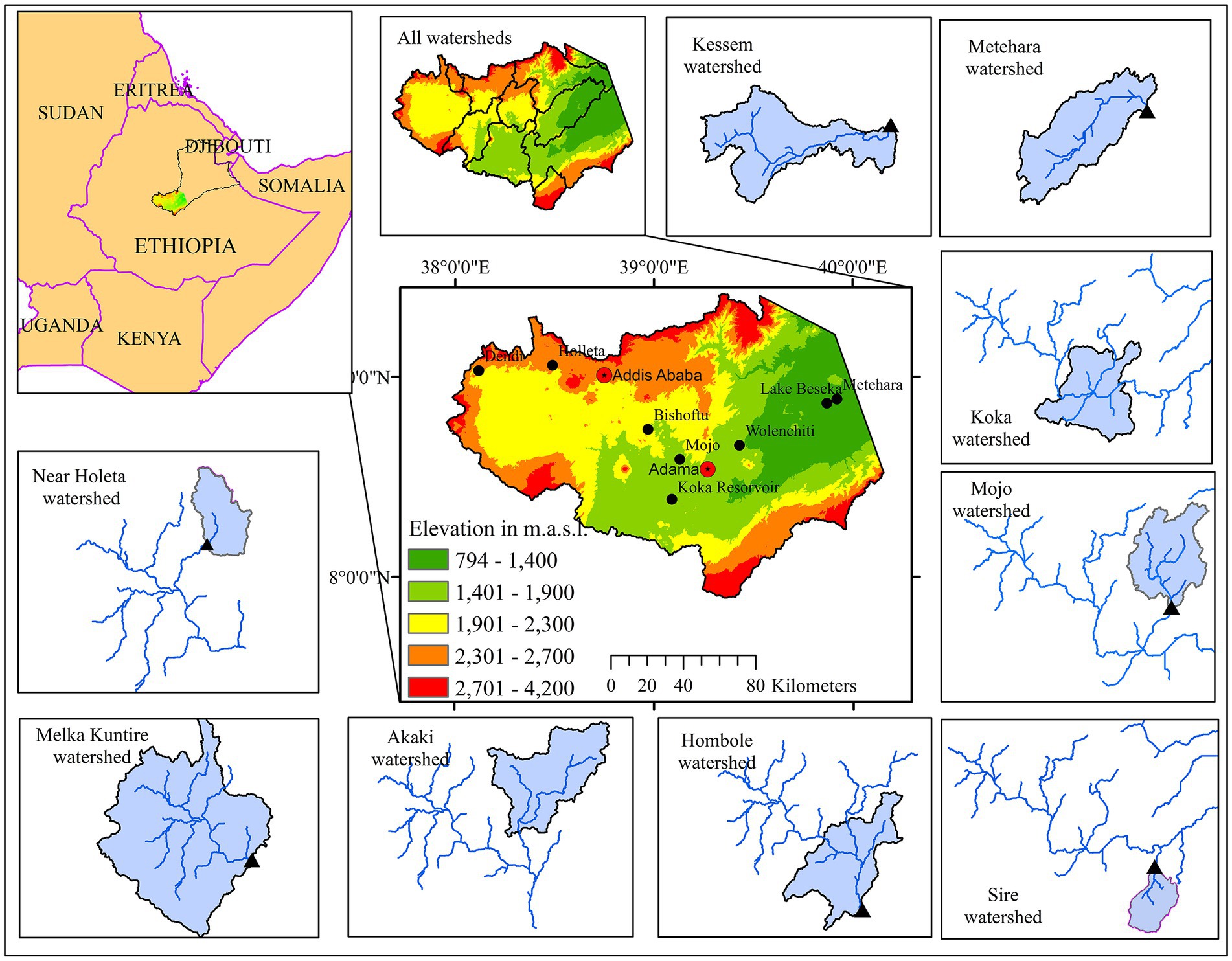
The upper Awash basin is characterized by a rugged extensive plateau reaching up to 4,177 m above sea level (a.s.l.) to the west and east of the MER. The central part of MER is comparatively low-lying (~794 m a.s.l.), and is characterized by extensive plains with some rift lakes, such as the Bishoftu crater lakes, Lake Beseka, and the Koka artificial reservoir (Ayenew, 2007, 2008; Adane et al., 2020a). The total area of the upper Awash basin considered in this study is ~23,761 km2. In this study, nine watersheds of the basin (Holleta, Melka Kuntire, Hombole, Akaki, Koka, Mojo, Sire, Kessem, and Metehara) were considered (Figure 1).
The temporal bimodal rainfall distribution — a short rainy season (February–May) and a long rainy season (June–September) — in the basin is influenced by the seasonal north–south migration of the Inter-Tropical Convergence Zone (Adane et al., 2020a,b; Hirpa et al., 2022). The average annual rainfall in the highlands of the Awash Basin (upstream of the Koka reservoir) is 985 mm, while it is 610 mm in the semi-arid central MER near Metehara (eastern part of the basin). The mean annual temperature increases from the western highlands to the eastern part of the central MER (8.6°C at mount Dendi and 25°C at Metehara; Minta et al., 2018; Adane et al., 2020a).
Cultivated land is the dominant land use type in the basin. A wide range of major cereals such as maize, teff, wheat, sorghum, chickpea, and barely are cultivated depending on the elevation ranges (Hirpa et al., 2022). Small-scale farmers in the western and eastern highlands rely on rainfed crops combined with livestock (cattle and sheep) production (Minta et al., 2018). Large-scale irrigation schemes (more than 22,000 ha of field), such as the Metehara, Wonji-Shoa, and Kessem sugar plantations, as well as large-scale fruit and vegetable farms, are common in the central MER. The upper Awash basin hosts the capital city, Addis Ababa, which has better infrastructure development. This leads to substantial population concentration, particularly in peri-urban areas, which results in the rapid conversion of various land types to settlement sites, i.e., urban sprawling (Dadi et al., 2016). The basin also hosts other major cities (e.g., Adama) and big towns, including Holleta, Bishoftu, Mojo, Wolenchiti, and Metehara. The population size of the 49 woreda administrations within the basin is ~7.32 million as recorded in 2012 (Shawul and Chakma, 2019). In addition, the population of Addis Ababa city, Adama and Mojo towns were estimated in 2021 to be ~3.8 million, ~435,000 and 58,000, respectively (CSA, 2013; ESS, 2021a). 58.8 to 68% of the economically active population (both employed and unemployed) live in Addis Ababa and surrounding towns such as Bishoftu, Burayu, Sabata, Ambo and Adama (ESS, 2021a).
2.2. Datasets
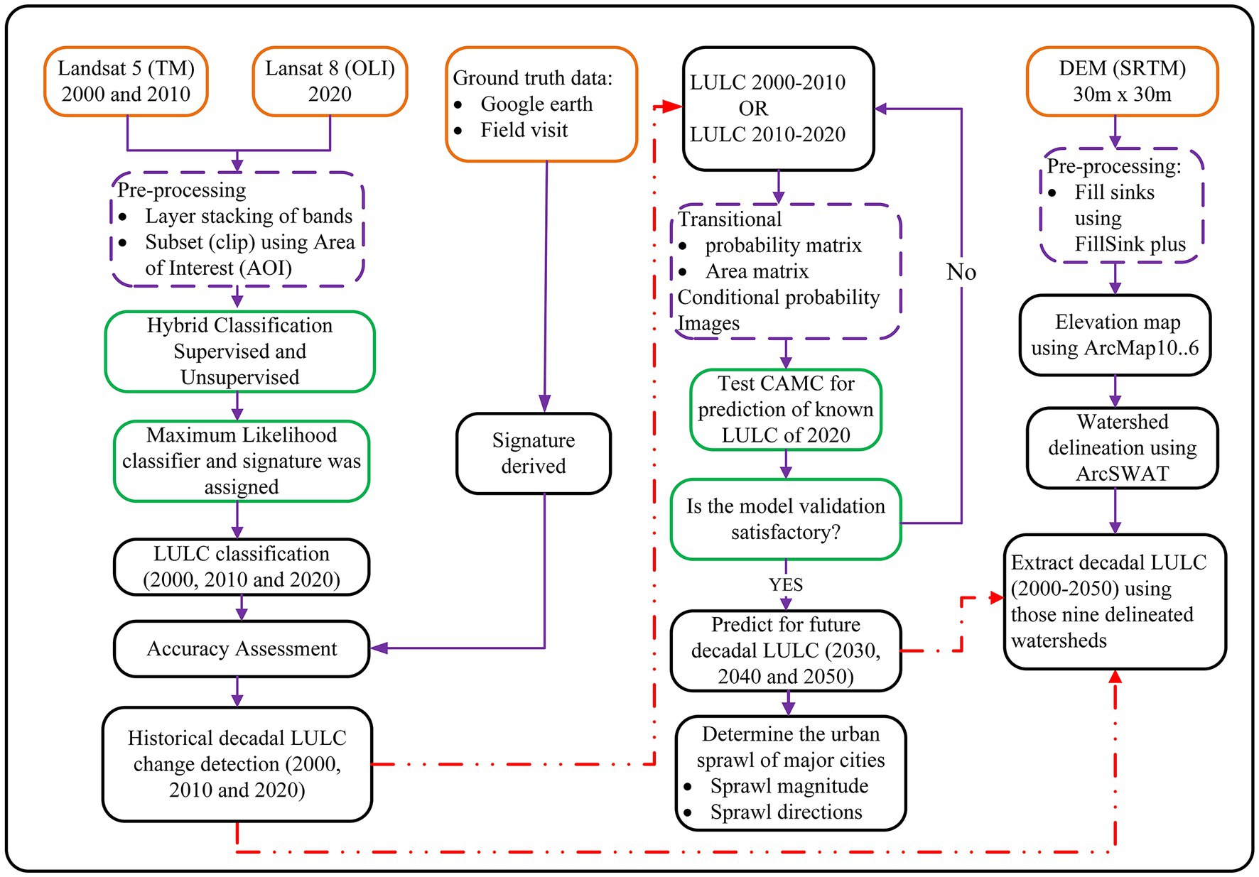
Various sets of satellite images were used to investigate historical decadal LULC changes in the study area from 2000 to 2020. Multi-temporal Landsat-5 Thematic Mapper (Landsat-5TM) and operational land imager (Landsat 8 OLI) data for the years 2000, 2010, and 2020 were acquired from the Center for Earth Resources Observation and Science of the United States Geological Survey (USGS). Cloud-free, dry-season (January and February) images (Table 1) were downloaded. Additionally, a 30 × 30 m resolution Shuttle Radar Topographic Mission digital elevation model (DEM) was downloaded from the USGS Earth Explorer site (Table 1), which was used to produce the elevation map (Figure 1), delineate the basin and watersheds using ArcSWAT extension of ArcMap 10.6, and extract the watershed characteristics.
Ancillary data, including validation set points (VSPs), were collected using a Garmin etrex 10 GPS and recorded using high-resolution imagery. VSPs were used to assess the accuracy of the classified LULCs. Land use classification was conducted using ERDAS IMAGINE 2014 software.
2.3. Image pre-processing and classification
A preliminary field investigation was conducted to identify dominant LULC classes. Accordingly, the basin was classified into seven classes (Supplementary Table S1): shrubland, bareland, settlement, forest land, cultivated land, grassland, and waterbody.
In this study, a Landsat 5TM and Landsat 8 OLI, which have been processed to Level-1 full Terrain Precision Correction (L1TP) with root-mean-square error (RMSE) of less than one and eight were used for the analysis, respectively (Supplementary Tables S2, S3). Thus, no image corrections were done on the processed images by the USGS. In addition, we checked the metadata information (including cloud cover, line scan errors, the quality score of the scene given as 9, which is good) of the downloaded image and we proceeded to make further analysis.
The bands in each of the four satellite scenes covering the study area were georeferenced using ground control points and projected with the Universal Traverse Mercator (UTM) of WGS84 zone 37. The layer stacked and mosaiced together with other scenes using ERDAS IMAGINE 2014 and ArcMap 10.6 software. The images were sized (subset) on the shapefiles using an Area of Interest to reduce the computational time in the large study area (~23,761 km2). The image band ration was adjusted to the RGB composite colors blue, red, green, and infra-red where the combined band ratio has allowed to better discriminate the LULC features.
A hybrid classification (both supervised and unsupervised) technique using a maximum likelihood classifier was used to prepare the probability density distribution functions for each LULC class, and signatures were assigned on the ERDAS IMAGINE software (Gebreslassie, 2014; Yohannes et al., 2018; Gebru et al., 2019). This study has combined the past decadal land use trends with a spatially explicit projection to quantify the magnitude, rates, and patterns of urban expansion and cropland loss including transformation into other land use types in the upper Awash basin. The overall methodological flowchart of this study is indicated in Figure 2.
2.3.1. Accuracy assessment
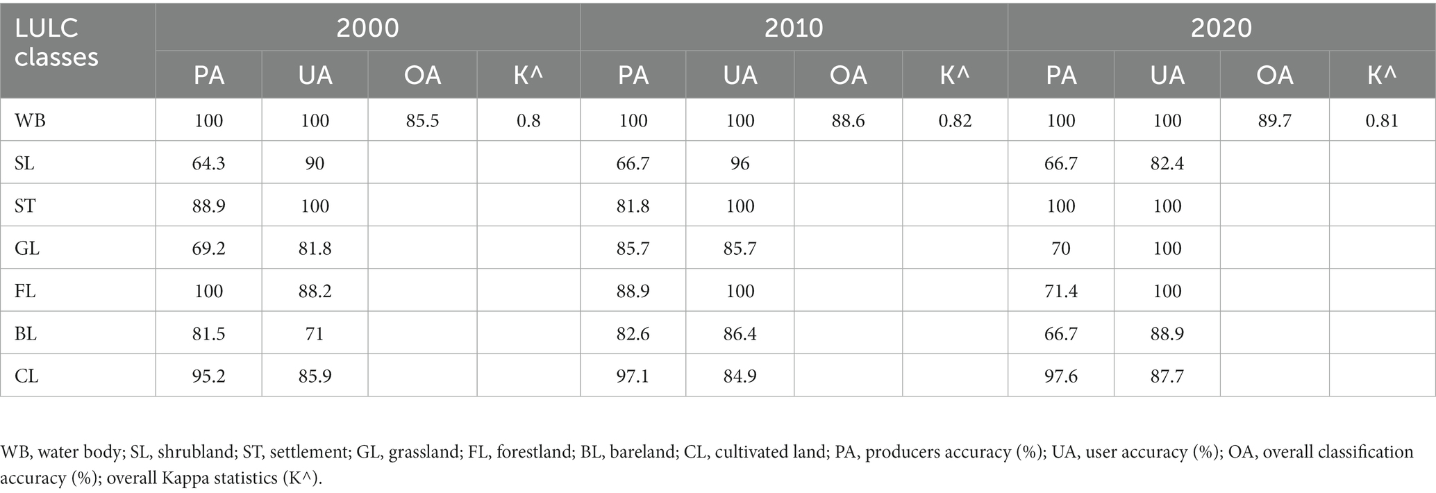
Accuracy of the individual classifications should be assessed if the classified data are to be useful for change detection (Owojori and Xie, 2003). Accuracy of the seven predefined classes was validated via VSPs using visual interpretation during the field survey. A stratified random sampling method was used to generate 200 accuracy assessment points using the classification and segmentation toolbox in ArcMap 10.6. The ArcMap considers each land use class as a stratum and then randomly samples/allocates the number of control points from each land use class in the proportion of to its size. Then the automatically generated samples are compared with the VSPs collected from the field. These accuracy assessment points were randomly distributed over the basin and represented the seven LULC classes. A total of 200 VSPs were collected from physically accessible areas with 1 m positional accuracy and used to validate the 2020 LULC classes. Furthermore, historical Google Earth images, various ancillary data including topographic maps, and visual inspection of the visited localities were used to check and validate the accuracy of historical (2000 and 2010) LULC.
Accuracy of the classified images was verified using the overall classification accuracy (OA) and kappa statistics (Congalton, 1991). OA shows the ratio of the number of correct classifications (NCC) to the total number of reference points (TNR). OA and Kappa coefficient (K^) were analyzed as indicated in Congalton (1991).
2.3.2. Historical LULC change detection
Post-classification changes were detected using statistical analysis for the periods 2000–2010, 2010–2020, and 2000–2020. This has been done using cross-tabulation matrix (transition matrix) using overlay function in ArcGIS 10.6 software. Changes in the LULC percentages (ΔLULC), magnitude of change (MC), annual rate of change (ARC), and LULC change matrix were generated. This analysis not only explores changes that have occurred in an area but also identifies their nature and determines their spatial extent and pattern (Gebru et al., 2019; Wang et al., 2020). The MC (ha), and ARC (%) for each LULC class during each period were computed based on Eqs. 1–4, respectively (Puyravaud, 2003; Deribew, 2020; Gebru et al., 2022):
where Af and Ai are the areal coverage of each LULC type for the final and initial years of computation, ΔLULC is the change in LULC between years, and Δt is the durations between the final and initial years.
2.3.3. Future LULC predictions
The CAMC model combines a CA filter and Markov chain procedure and is applied to predict future land-use changes (Singh et al., 2015; Mondal et al., 2016; Wang et al., 2020). The CA is a discrete – in time, space, and state–grid dynamic model (Wang S. Q. et al., 2012). Decadal LULC predictions for 2030, 2040, and 2050 were modeled using CAMC in IDRISI Selva software version 17.02. This model can simulate spatial variations in complex systems. The transition probability matrix was generated by cross-tabulating two different images (Fathizad et al., 2015; Wang et al., 2020). Prior to analysis, a pair of LULC images (2000–2010 and 2010–2020) and outputs of a transition probability matrix, a transition area matrix, and a set of conditional probability images were analyzed to be used as inputs for the CAMC model to predict future land use changes.
The probability of change of the seven LULC categories to other categories was given by a transition probability matrix. The transition area matrix records change in the number of pixels from each land cover type to other in a given time unit (Eastman, 2012). Two transitional matrices (2000–2010 and 2010–2020) were computed using the LULC images from 2000, 2010, and 2020. The transitional matrix of 2000–2010 was used to predict the 2020 LULC, which was validated using LULC reference data for the same year. Finally, using the 2010 and 2020 images, we modeled future decadal land use (in 2030, 2040, and 2050) changes in the upper Awash basin. The predicted LULC changes were validated using a method indicated by Pontius (2000), Pontius et al. (2004), Omar et al. (2014), and Singh et al. (2015).
2.4. Urban sprawl in the upper Awash basin
Urban sprawling effects on peri-urban areas by converting to other land uses are common (Hasse and Lathrop, 2003; Siedentop and Fina, 2010; Deribew, 2020). In this study, an attempt was made to identify in which concentric shield rings the built-up areas (settlements) are densely located in reference to the urban center (centroid) for three cities/towns: Addis Ababa, Adama, and Mojo. Sprawl directions were identified by assigning four zones: northeast (NE), southeast (SE), southwest (SW), and northwest (NW). The classified LULC change images were then overlaid on ArcMap 10.6. Concentric shield rings with a 2 km interval covering a total radius of 22 km from Addis Ababa, 12 km radius for Adama, and 8 km radius from Mojo were considered based on their areal coverage. Finally, the urban sprawl direction and its concentration radius from the centroid of the selected cities and towns were analyzed.
3. Results
3.1. Accuracy assessment
Accuracy assessment of the results showed that the classified LULC was in general agreement with the existing conditions of the upper Awash basin, where the K^ for all three considered periods was >0.80, while the overall accuracy was >85.5% (Table 2).
3.2. Past/present LULC conditions
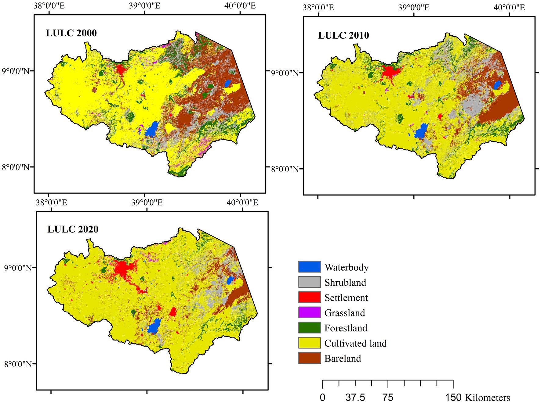
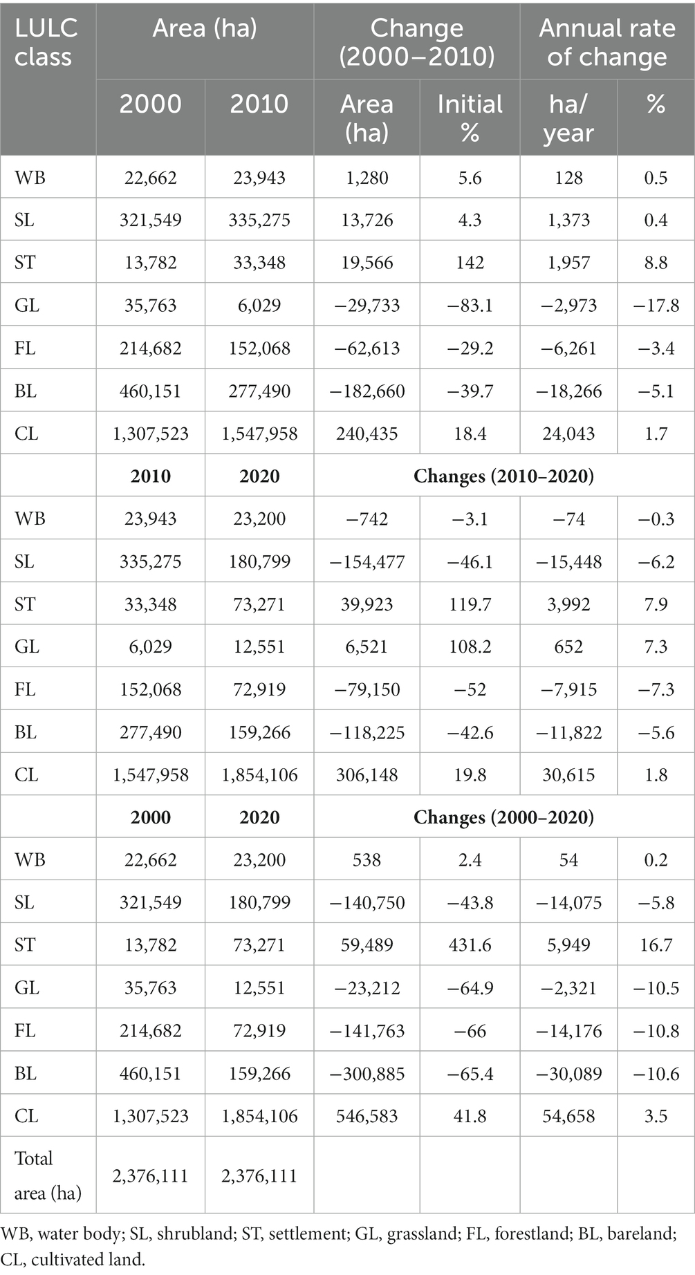
The results show a clear ARC increase from 2000 to 2020 in settlements and cultivate land, with a reduction in forestland and bareland in the upper Awash basin (Figure 3). The confusion matrix of the historical LULC is indicated in Supplementary Table S4.
Currently, the western part of the basin (the western highlands) is dominated by intensive small-scale subsistence farming, while the low-lying central, northeastern, and eastern parts (the central MER) are characterized by large-scale irrigation farms. Patches of forests survive on some isolated peaks in the central part of the basin and in the eastern highlands. The Addis Ababa – Mojo – Adama corridor is a major urban area, while remnants of shrubland and bareland can be observed in the northeastern lowlands of the basin.
3.3. LULC change detection
Post-classification comparison provides an account of the amount and type of change that has occurred for each LULC class. The annual rate of change for the periods 2000–2010, 2010–2020, and 2000–2020 was generated by comparing the classified maps of 2000, 2010, and 2020 (Figure 4). The decadal changes are described below based on Figure 4; Table 3.
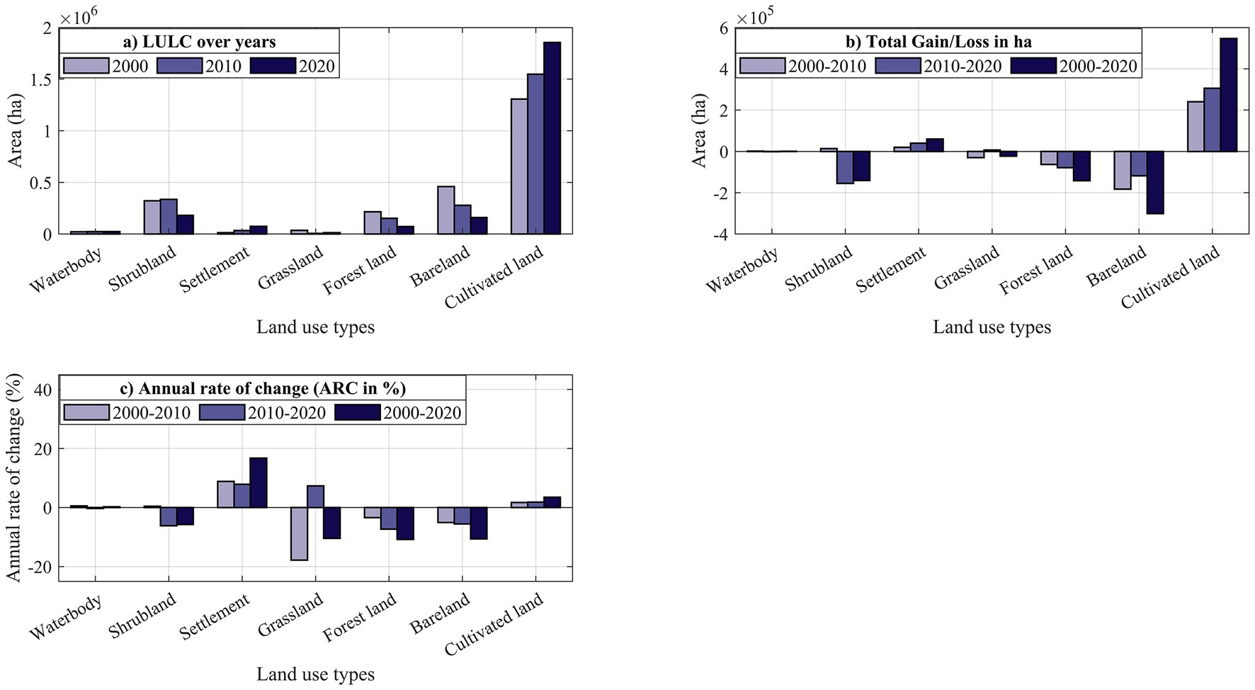
Figure 4. Historical areal coverage of LULC, total gain/loss and the annual rate of change in the LULC classes in the upper Awash basin for the period 2000–2020.
From 2000 to 2020, settlements, cultivated land, and waterbody expanded while shrubland, grassland, bareland, and forestland shrank by different extents. Settlements expanded by a staggering magnitude of 432% at an average annual rate of 17%, whereas cultivated land expanded by a modest magnitude of 42% at an average annual rate of 3.5%. The surface area of waterbodies increased by 2.4%, which can be mostly related to the significant expansion of Lake Beseka due to groundwater input (Dinka, 2012, 2017), despite the loss of wetlands in the western highlands (Gebresllassie et al., 2014; Tolessa et al., 2018). Settlement and cultivated land expanded at the expense of declining forestland (by 66%), grassland and bareland (by 65% each), and shrubland (by 44%).
The change matrix results revealed that ~35% (829,890 ha), 28% (666,096 ha), and 41% (971,231 ha) of the total area (2,376,111 ha) of the upper Awash basin experienced significant changes in LULC during the 2000–2010, 2010–2020 and 2000–2020 periods, respectively (Supplementary Table S5). Land conversion was mainly due to the consistent and significant expansion of settlements and cultivated land and the consistent shrinkage of forestland and bareland during the last two decades. Grassland, shrubland, and waterbodies showed some variability during the last two decades; however, the overall area of shrubland and grassland declined and that of waterbody expanded from 2000 to 2020 (Supplementary Table S5).
3.4. Future LULC prediction
3.4.1. Transitional probability matrix
The two qualitative LULC images (2010 and 2020) produced a transitional probability matrix for 2030, 2040, and 2050 (Supplementary Table S6). This matrix shows the possibility of a pixel of a given class to change to any other class (or remain the same) in the next period (Eastman, 2012). Grassland, forestland, bareland, and shrubland showed relatively higher probabilities of conversion (values closer to 1 in Supplementary Table S6) to cultivated land in the years 2030, 2040, and 2050. On the other hand, the waterbody, settlement, and cultivated land transition matrices showed a limited rate of conversion to other LULC classes, with at least 95% of settlements, 84% of cultivated land, and 82% of waterbody remaining intact.
3.4.2. Validation of future LULC prediction
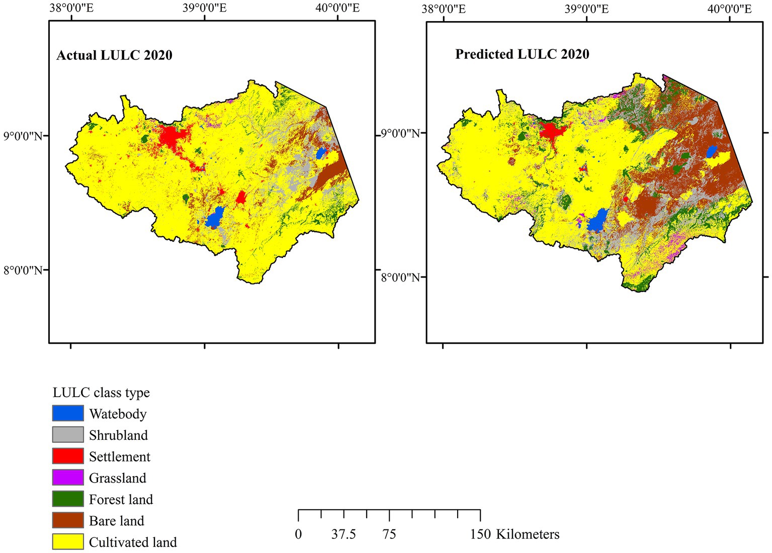
The actual LULC of 2020 was compared with the predicted LULC of the same year based on the CAMC model using the 2000 and 2010 LULC images (Figure 5). The actual land use showed greater settlement expansion around major cities (e.g., Addis Ababa and Adama) and cultivated land expansion in the eastern part of the basin (Figure 5). This is also in agreement with earlier studies that confirmed major expansions of the size of Addis Ababa by 77%, while the population increased by 74% during the last two decades, particularly since 2010 (Koroso et al., 2020). However, the predicted image of 2020 showed less settlement coverage, while the bareland in the eastern part of the basin was also overestimated compared with the actual LULC map of 2020 (Figure 5). The discrepancies between the actual and predicted LULC maps for 2020 are possibly due to the significant ST expansion after 2010 in the basin, particularly the massive expansion of the Addis Ababa–Adama corridor. To adjust for these discrepancies, the actual LULC of 2010 and 2020 was used to predict future (2030, 2040, and 2050) LULC changes. Furthermore, the classification agreement/disagreement analysis to specify the quantity and allocation for predicting the 2020 LULC is shown in Supplementary Tables S7, S8.
3.4.3. Future LULC changes and dynamics
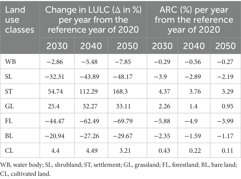
Forestland and shrubland showed a steady decline in areal coverage from the reference year 2020 to the next three decades. Similarly, bareland and waterbody also show declining patterns (Table 4). On the other hand, settlement, grassland, and cultivated land showed expansion in the next three decades by different extents compared to the reference year 2020. The extent of settlement will expand significantly by 2030 (by 55%), 2040 (by 112%), and 2050 (by a staggering magnitude of 168%).
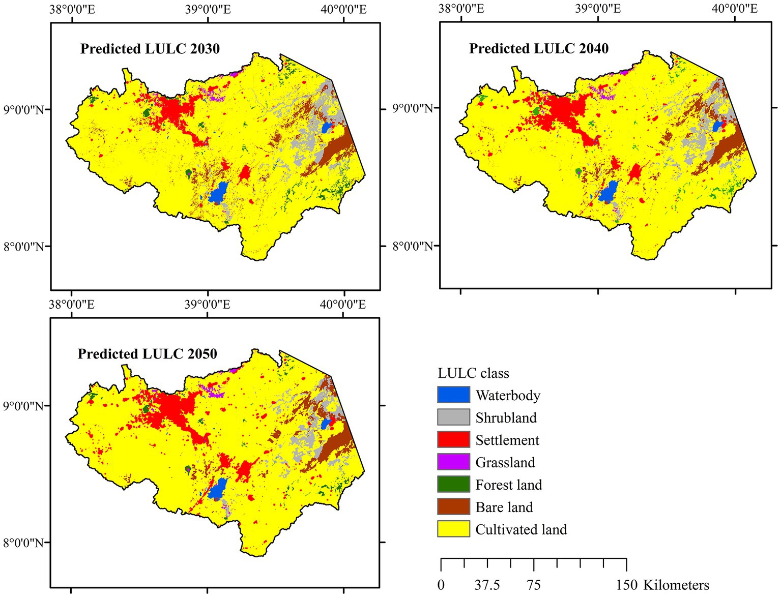
Settlements will expand by a similar rate of ARC during the 2020–2030, 2030–2040 and 2040–2050 periods (Table 4). The expansion of settlements will be mainly concentrated along the Addis Ababa–Adama corridor (Figure 6). Barelands will decline in the eastern part of the basin (Figure 6); however, the decline will slow down slightly from 2030 to 2050. Similarly, shrublands in the eastern part of the basin will reduce in the next three decades (Table 4). Forestland showed reduction in the next three decades with respect to the reference year 2020. Cultivated land showed expansion of ~4.5% in 2030 and 2040, which relatively will slow down by 2050 (3.2%).
In terms of total LULC, cultivated land will remain dominant in the coming decades, although its extent will slightly increase from the reference year 2020 (Supplementary Table S9). In 2020, cultivated land covered 78% of the basin, and will cover at least ~81% of the basin in the coming three decades. While all the other LULC classes showed a limited expansion (grassland) or decline (waterbody, shrubland, forestland, and bareland) in the total areal coverage from 2020 to 2050, settlements showed the largest change. It covered only 3.1% of the total area of the basin in 2020, which became more than double to 8.3% of the basin in 2050 (Supplementary Table S9). The settlement expansion (mostly urban and peri-urban settlements) could be at the expense of other classes, particularly cultivated land. This future trend of urban expansion in the upper Awash basin has been consistent with the large-scale boundary expansion of major cities, such as Addis Ababa, since 1993 (Koroso et al., 2020).
3.4.4. LULC over watersheds of the upper Awash basin
The total areas for the nine watersheds of the upper Awash basin evaluated in this study are listed in Table 5. Cultivated land dominates most of the watersheds in the western and eastern highlands (Holleta, Akaki, Melka Kuntire, and Sire watersheds), as well as the plateau-rift escarpment zones (Hombole, Mojo, and Koka watersheds), and is represented by small-scale rain-fed farming. However, cultivated land is not dominant in the eastern part of the basin (Kesem and Metehara watersheds), which is dominated by shrubland and barelands, with isolated large-scale farming. In the next three decades, settlements will steadily expand at the expense of cultivated land and other LULC classes in all watersheds, particularly upstream of the Koka watershed, with an average decadal LULC change of 42% in the Akaki and 26% in the Holleta watershed. The Addis Ababa–Adama corridor straddles the Akaki, Koka, and Mojo watersheds, which explains this trend in settlements growth. In the Mojo and Koka watersheds, settlement expands at a decadal average of 7 and 6% by 2030 and 2050, respectively.
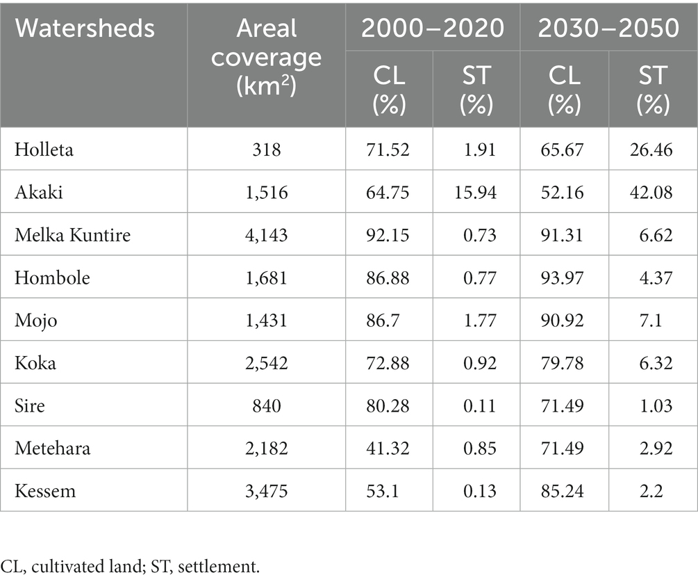
Table 5. Average decadal percentage of past and future LULC changes in seven watersheds of the upper Awash basin.
3.5. Urban sprawl in the upper Awash basin
The urban sprawl during the 2000–2020 period was analyzed using concentric rings around the centroid of the two major cities in the basin, Addis Ababa and Adama, and Mojo town, located along the Addis Ababa–Adama corridor, which is the major import–export route of the country (Figure 7). These areas have undergone rapid expansion over the last two decades (10,650 ha in 2000 to 42,651 ha in 2020; Table 6). Addis Ababa expanded in all directions, particularly along the Addis Ababa–Adama corridor, resulting in the interconnection of previously isolated towns of Dukem and Bishoftu with the city by 2020. Additionally, Addis Ababa has expanded to the west and southwest, and has been interconnected with the towns of Alem Gena and Sebeta-Awas by 2020. Urban growth expands from the centroid (urban center) towards the periphery (peri-urban settlements).
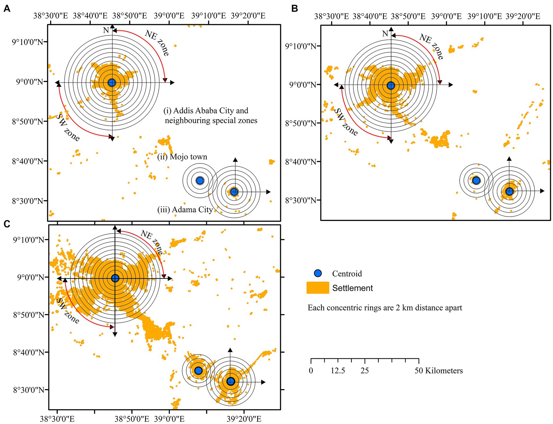
Figure 7. Settlement (built-up) area expansions, concentric rings and zones of major cities/towns in the upper Awash basin in: (A) 2000, (B) 2010, and (C) 2020.

Table 6. Settlement area coverage (ha) between 2000 and 2050 in major cities and towns of the upper Awash basin.
In 2000, Addis Ababa’s built-up concentration was within a 6 km radius from the urban center and accounted for only ~7,007 ha of land (Table 6), with some dispersed settlements along the NE, SE, and NW directions within a 12 km radius. This expansion accounted for nearly all of the urban sprawl of Addis Ababa in 2000 (10,650 ha), except for a narrow strip along the SSE direction, which was beyond the 12 km radius (Figure 7). In 2010, the built-up area concentration in the urban sprawl of Addis Ababa was within an 8 km radius from the centroid, accounting for ~14,558 ha of land, i.e., more than double the size since 2000. In 2020, the built-up area concentration was within a 10 km radius and accounted for 23,976 ha of land (Table 6). However, since 2010, urban sprawl from Addis Ababa has reached 22 km from the centroid without a major break in the built-up area concentration along the SE, NE, NW, and SW directions, with annual built-up area rates of change of 7.6 and 6.2% in 2000–2010 and 2010–2020, respectively. The total urban sprawl within a 22 km radius of the centroid of Addis Ababa was ~22,887 ha in 2010 and a staggering ~42,651 ha in 2020 (Table 6). The city has been expanding towards CLs on the wide plains of the plateau and the MER, while its expansion to the north is checked by the rugged mountain ridges of Entoto and Yeka, which mark the boundary between the rift and the plateau.
Adama City and Mojo Town have shown similar expansions during the last two decades (Figure 7; Table 6). Adama city has shown an annual expansion rate of 9.7% both during the 2000–2010 and 2010–2020 periods while Mojo town has sprawled by 9 folds, from only ~292 ha in 2010 to ~2,696 ha in 2020 (Table 6).
The predicted percentage change in settlement for Addis Ababa and its neighboring districts within 22 km radius from the centroid shows a 40% expansion in 2030, 77% in 2040, and 87% in 2050 compared with the reference year 2020 (Table 6; Figure 8). Similarly, the Mojo town will expand significantly in 2030 (54%), 2040 (119%), and 2050 (by a staggering magnitude of 244%), while Adama will expand within the 12 km radius by 18, 42, and 117% in the next three respective decades (Figure 8). In the past two decades, the cultivated lands around Addis Ababa declined as a result of urban sprawling by 9.4 and 4.2% during 2000–2010 and 2010–2020, respectively. In Adama City and its surroundings, the cultivated land showed expansion by 114% in 2010 with respect to 2000 and declined in 2010–2020 (by −2.9%). Similarly, the cultivated land will shrink in urban and peri-urban vicinities of Addis Ababa (by ~15, 33, and 39%), Mojo (by ~5, 11, and 30%), and Adama (by ~1, 3, and 18%) in the next three consecutive decades.
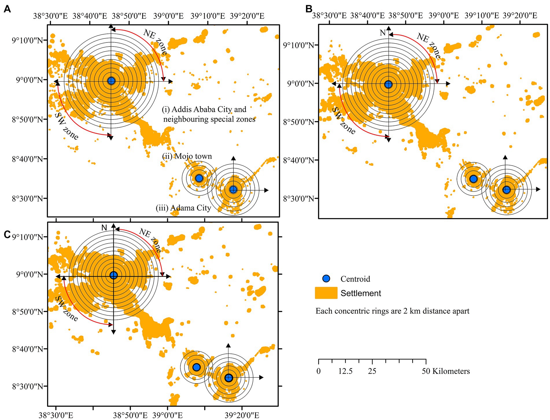
Figure 8. Predictive maps of major cities/towns with concentric rings in the upper Awash basin in: (A) 2030, (B) 2040, and (C) 2050.
4. Discussion
4.1. Drivers of past and future LULC changes
The upper Awash basin is characterized by intensive small-scale farming in the western and eastern highlands and by large-scale irrigated farms in the central MER, particularly in the eastern part of the basin, such as sugar estates and fruit farms (Minta et al., 2018; Hirpa et al., 2022). The cultivated land has been the dominant LULC class in the Awash basin until 2020, but this study showed that its extent will decrease during the next three decades to give way to settlements that will show an exponential growth from a meager 0.6% (13,782 km2) of the upper Awash basin in 2000 to 8.3% (197,217 km2) in 2050.
The significant expansions in settlement areas in the upper Awash basin are attributed to population growth, rural-to-urban population migration, large-scale infrastructural developments such as road and rail networks, establishment and expansion of industrial zones, and flower farming (Chirisa, 2008; Wubneh, 2013). The population of Addis Ababa has grown from ~2.5 million in 2000 (Kassa, 2013) to ~3.8 million in 2021 and is projected to become 5.2 million in 2037. The populations of Adama and Mojo expanded from ~130,000 and 22,000 in 1994 to ~435,000 and 58,000 in 2021, respectively (CSA, 2013; ESS, 2021a). According to the labor force and migration survey report by the Ethiopian Statistics Service (ESS) in 2021, Addis Ababa City had the highest gain of lifetime migrants (292 persons per 1,000 population) compared to other cities/towns of Ethiopia (ESS, 2021b). This necessitated building more housing units to accommodate the growing numbers of both population and industry. This has led to significant urban sprawl in big cities (Addis Ababa and Adama) and smaller towns (Holleta et al., Mojo, Wolenchiti, and Metehara, among others). Most of these expansions were at the expense of cultivated land, grassland, shrubland, bareland, and some forest cover.
Settlements and cultivated land have expanded parallelly during the last two decades, although cultivated land has also been converted to settlements. Following the Agricultural Development Led Industrialization policy of the 2000s, cultivated land expanded mainly due to increased demand for food, which is one of the major factors that contributed to the reduction of natural vegetation cover, where more areas between 2000 and 2020 were used to cultivate irrigated and rainfed crops (Zewdie, 2015; Dube et al., 2019). Agricultural land expansion and population growth have put pressure on the natural environment and have significantly reduced forestland, shrubland, and grassland coverage in the upper Awash basin over the last two decades (Beyene and Muche, 2010; Tefera, 2010). This encouraged farmers to boost food production in a very stressed basin, leading to more investment in agricultural inputs, such as land, fertilizers, pesticides, seeds, agricultural machinery, laborers, wages, and a skilled workforce, causing the sprawling of urban and semi-urban settlements. Meanwhile, this situation also created more competition for land use, leading to conversion of cultivated land to built-up areas (settlements) in many cases. However several studies confirmed that considerable agricultural land losses in peri-urban areas are observed in recent decades due to unplanned expansion of built up areas in many of Ethiopian cities (Mohamed and Worku, 2019; Worku, 2020; Erasu Tufa and Lika Megento, 2022). The reduction of cultivated land has a direct influence on the amount of crop production (Pham Thi et al., 2021). Erasu Tufa and Lika Megento (2022) found a decreasing trend in crop production (teff, wheat and barley) in four woredas of peri-urban Addis Ababa between 1996 and 2020. Dadi et al. (2016) also recorded that the cultivated land in peri-urban areas of Addis Ababa has been reduced by ~28% in Gelan and ~ 48% in Dukem between 2004/05 and 2012/13 due to rapid industrial development and settlement expansions.
On a large scale, the rate of change of agricultural land can also be significantly affected by shifts in the political and economic regime (Schierhorn et al., 2013; Winkler et al., 2021). For instance, the expansion of flower farms in Ethiopia triggered a significant LULC change during the last two decades, and its effects are believed to continue in the coming decades. Ethiopia is one of the largest flower suppliers, the second largest in Africa, to the global market since 2001, and more than 84 active flower farms are operating in the country (Mengistie, 2020). Approximately 90% of the flower farms are situated in the central highlands of Ethiopia: Holleta, Walmera district, Sebeta, and Ejere, mostly in the upper Awash basin, and some others in the Lake Ziway Basin (Gobie, 2019; Abate, 2020). Similarly, Oqubay (Oqubay, 2015) reported that 90% of non-floriculture (vegetables, fruits, herbs) as well as flower farms are concentrated around Addis Ababa in central Ethiopia, which is the export hub for flower markets around the world. The concentration of flower farms has significantly contributed to the expansion of settlements in peri-urban areas.
Other works in the upper Awash basin, though fragmental, have shown similar LULC changes in various parts of the basin. Industrialization, residential expansion, and infrastructural development have been reported as the leading drivers for conversion of agricultural land to settlements, expanding the peri-urban sprawls around Dukem Town at the center of the basin (Dadi et al., 2016). LULC dynamics have also seriously impact food production in the region (Dadi et al., 2016). Similar urban and peri-urban expansion has been recorded in several other towns in the basin, such as in the Sebeta-Awas town, which expanded by 55% in 2002 and by another 15% in 2019 from 1986 (Deribew, 2020). Tufa and Megento (2022) reported a rapid transformation (by ~90%) of farmland (cultivated land) into urban areas (settlements) between 1986 and 2020 around Addis Ababa. They attributed the major losses of cultivated land in the peri-urban areas of Addis Ababa to the unplanned expansion of built-up areas towards agricultural regions. They further indicated a combination of factors, including governmental policy on land use, socioeconomic and demographic dynamics, and biophysical conditions of the area to be the major triggering factors for land transformation.
4.2. LULC predictive maps and policy development for sustainable land use
Predictive LULC maps have been successfully utilized for policy development and land-use planning in several countries. For instance, López et al. (2001) studied urban settlement growth with future LULC changes in Morelia City, Mexico. Sun et al. (2007) modeled urban land use change and urban sprawl in the city of Calgary, Canada, to plan the transportation network in the city. Fricke and Wolff (2002) investigated the urban sprawl using the built-up areas and transportation network databases for the Brussels area. Wang J. et al. (2012) investigated the driving forces of land use changes and policy dimensions in China for past, present, and future conditions. Al-sharif and Pradhan (2015) developed a future predictive map for the city of Tripoli, Libya, and investigated the urban expansion dynamics, including the spatiotemporal patterns, to estimate the future demand of urban land. Yiran et al. (2020) who reviewed the literature on urban sprawl in Sub-Saharan Africa (SSA), pointed out that such types of studies are rare in SSA countries, particularly in eastern Africa. This is despite the fact that the eastern African countries are currently showing the fastest rate of urbanization compared to more urbanized regions of SSA, particularly the southern African region (UNECA, 2017). Yiran et al. (2020) found out that urban sprawl in SSA is causing a reduction of cultivated land leading to a raising concern of food security in the affected rural communities. They further recommended the use of remote sensing/GIS along with ethnographic methods to better capture the complexity and impacts of urban sprawl in SSA. Thus, if sustainable land use is to be achieved in complex settings, such as the upper Awash basin, land use policy and planning must rely on possible trends identified in the predictive maps produced in this study. An institute should be formed, where such data can be systematically archived and utilized. However, a recent study on the role of institutional actors and their interaction in land-use policymaking in Ethiopia reported prevalent structural organizational problems in land-use institutions, poor participation of lower-level governmental institutions in land-use policymaking, lack of policy awareness, and absence of clear institutional mandates (Ariti et al., 2019). Moreover, although several land use planning policies have been introduced over the years, most of them were only implemented on trial and not synchronized with the previously planned policies (Azadi et al., 2021). This discordance resulted in overlaps, redundancies, and ineffective cadastral structures within the country (Azadi et al., 2021), which in turn led to the ineffective implementation of land use policy and management practices. Synchronized land use policy and legislation based on empirical data, such as predictive LULC maps, as well as a strong and effective institutional setup that cascades to the lower implementing agencies and communities, are thus required to reduce the effects of implementing inappropriate land use systems.
4.3. Implications and limitations of the study
Although our study was limited to decadal resolution to quantify the magnitude and rates of cultivated land losses due to urbanization, the results definitely show that rapid urban expansion has been happening at the expense of highly productive agricultural lands in central Ethiopia. This study has quantified the extent of agricultural land lost to urban expansion and objectively predicted the future extent of such loss. The reduction in crop production in peri-urban areas contributed to a rise in food prices and pose challenges to food security to meet the growing demands of the urban population (Tufa and Magento, 2022). The result of our study, therefore, will assists in developing and implementing appropriate land use planning for sustainable food production in the basin (addresses SDG 2: Zero Hunger) and in turn helps to ensures the farmers’ livelihood in the peri-urban areas of the major cities of central Ethiopia (addresses SDG 15: Life on land: Reversing man-made deforestation and desertification to sustain all life on earth). Thus, our work has practical uses in developing land use monitoring schemes across the basin for sustainable urban and peri-urban development and in efforts to alleviate future food scarcity, biodiversity losses and maintain ecological balance in the basin. However, our study did not quantify actual crop production losses, neither did it include analysis of economic loss related to land reduction/conversion and its impact on livelihoods.
The basin-wide approach we adopted in our work could be a good framework for investigating the interactions of various LULC components. This approach also helps to use our findings for investigating the impact of the land use and landcover changes including urban sprawls on water resources within the basin, which in turn will be useful for developing sustainable water management strategies.
5. Conclusions and perspectives
Our study shows that the last two decades (2000–2020) have seen major changes in the settlement and cultivated land where settlements, particularly urban sprawls, substantially expanded at the expense of cultivated land and other LULC classes. Cultivated land modestly expanded at the expense of forestland, bareland and shrubland. In the next three decades (2030–2050), waterbody, shrubland, bareland, and forestland will steadily decline while settlement, grassland and cultivated land will expand. The expansion of settlements will be very significant compared to the other LULC changes. Although cultivated land will remain the dominant LULC class in the coming three decades, its total extent will not show much variation, as the offset from settlement expansion will be compensated by its expansion to other LULC classes. However, settlements will show the largest change in areal coverage, where their size (urban and peri-urban sprawls), will be more than double in 2050 compared to that in 2020. Since 1993, the large-scale boundary expansion of major cities, such as Addis Ababa, is consistent with the future trends of LULC in our predictive models of the upper Awash basin.
In the Akaki, Mojo, and Koka watersheds, where the major urban sprawl along the Addis Ababa–Adama corridor is located, settlement will steadily expand at the expense of cultivated land and other LULC classes in the next three decades. The size of the urban sprawl of Addis Ababa has grown more than six times in 2020 compared to that in 2000 such that the urban sprawl of Addis Ababa is now interconnected with all the formerly isolated towns nearby. Further, Addis Ababa has been expanding in nearly all directions towards cultivated lands on the wide plains of the plateau and the MER. Similarly, Adama City and Mojo Town have expanded significantly over the last two decades.
We suggest that future studies focus on quantifying crop production loss due to urban sprawling in specific hot spots in the basin. As reduction in cultivated land impacts crop production leading to the rise of crop prices, this creates challenges in achieving SDG 2 and SDG 15 in the upper Awash basin. In addition, proper and coordinated land-use planning for environmental and ecological management is lacking in the upper Awash basin. Thus, sustainable land use policy can only be effective if it relies on empirical data and possible future trends in LULC identified in predictive maps, such as those produced in this study. A proper institute where such data can be systematically archived and utilized for integrated policy development for environmental and ecological management is also required.
Data availability statement
The original contributions presented in this study are included in the article/Supplementary material. Requests to access the raw datasets should be directed to corresponding author BH (YmlydHVhYmthbkBnbWFpbC5jb20=).
Author contributions
BH, AA, and DN: Conceptualization, methodology, data curation and formal analysis. BH and GA: software. BH, AA, GA, DN, CS, MR, and W-KL: validation and writing – review and editing. BH, GA, and W-KL: resources. BH and AA: writing: original draft preparation. AA and DN: supervision. BH and W-KL: funding acquisition. All authors contributed to the article and approved the submitted version.
Funding
This study is supported by OJEong Resilience Institute (OJERI) at Korea University under the Basic Science Research Program through the National Research Foundation of Korea (NRF)(NRF-2021R1A6A1A10045235), the Korea Agency for Infrastructure Technology Advancement (KAIA) grant funded by the Ministry of Land, Infrastructure and Transport (22UMRG-C158194-03), and R&D Program for Forest Science Technology by Korea Forest Service (Korea Forestry Promotion Institute) (2021345B10-2223-CD01).
Acknowledgments
This work is part of the Ph.D. dissertation of BH at the Africa Center of Excellence for Water Management, Addis Ababa University, under the supervision of AA and DN. The United States Geological Survey (USGS) Center for Earth Resources Observation and Sciences (EROS) and the USGS Earth Explorer are credited for providing data free of charge. Tenalem Ayenew and Alemseged Tamiru are acknowledged for providing feedback on the earlier versions of this work.
Conflict of interest
The authors declare that the research was conducted in the absence of any commercial or financial relationships that could be construed as a potential conflict of interest.
Publisher’s note
All claims expressed in this article are solely those of the authors and do not necessarily represent those of their affiliated organizations, or those of the publisher, the editors and the reviewers. Any product that may be evaluated in this article, or claim that may be made by its manufacturer, is not guaranteed or endorsed by the publisher.
Supplementary material
The Supplementary material for this article can be found online at: https://www.frontiersin.org/articles/10.3389/fevo.2023.1160987/full#supplementary-material
References
Abate, A. G. (2020). The effects of land grabs on peasant households: the case of the floriculture sector in Oromia, Ethiopia. Afr. Aff. (Lond). 119, 90–114. doi: 10.1093/afraf/adz008
Adane, G. B., Hirpa, B. A., Lim, C. H., and Lee, W. K. (2020a). Spatial and temporal analysis of dry and wet spells in upper Awash river basin, Ethiopia. Water (Switzerland) 12, 1–18. doi: 10.3390/w12113051
Adane, G. B., Hirpa, B. A., Song, C., and Lee, W. K. (2020b). Rainfall characterization and trend analysis of wet spell length across varied landscapes of the upper Awash river basin, Ethiopia. Sustain. 12, 1–14. doi: 10.3390/su12219221
Aitkenhead, M. J., and Aalders, I. H. (2009). Predicting land cover using GIS, Bayesian and evolutionary algorithm methods. J. Environ. Manag. 90, 236–250. doi: 10.1016/j.jenvman.2007.09.010
Alberti, M. (2005). The effects of urban patterns on ecosystem function. Int. Reg. Sci. Rev. 28, 168–192. doi: 10.1177/0160017605275160
Al-sharif, A. A. A., and Pradhan, B. (2015). A novel approach for predicting the spatial patterns of urban expansion by combining the chi-squared automatic integration detection decision tree, Markov chain and cellular automata models in GIS. Geocarto Int. 30, 858–881. doi: 10.1080/10106049.2014.997308
Ariti, A. T., van Vliet, J., and Verburg, P. H. (2019). The role of institutional actors and their interactions in the land use policy making process in Ethiopia. J. Environ. Manag. 237, 235–246. doi: 10.1016/j.jenvman.2019.02.059
Arneth, A., Brown, C., and Rounsevell, M. D. A. (2014). Global models of human decision-making for land-based mitigation and adaptation assessment. Nat. Clim. Chang. 4, 550–557. doi: 10.1038/nclimate2250
Ayenew, T. (2007). Water management problems in the Ethiopian rift: challenges for development. J. African Earth Sci. 48, 222–236. doi: 10.1016/j.jafrearsci.2006.05.010
Ayenew, T. (2008). The distribution and hydrogeological controls of fluoride in the groundwater of central Ethiopian rift and adjacent highlands. Environ. Geol. 54, 1313–1324. doi: 10.1007/s00254-007-0914-4
Azadi, H., Movahhed Moghaddam, S., Mahmoudi, H., Burkart, S., Dadi Debela, D., Teklemariam, D., et al. (2021). Impacts of the land tenure system on sustainable land use in Ethiopia. Transit Sustain Life Land 15, 225–261. doi: 10.3390/books978-3-03897-879-4-11
Belay, S., Amsalu, A., and Abebe, E. (2014). Land use and land cover changes in awash National Park, Ethiopia: impact of decentralization on the use and management of resources. Open J. Ecol. 4, 950–960. doi: 10.4236/oje.2014.415079
Beyene, F., and Muche, M. (2010). Determinants of food security among rural households of central Ethiopia: an empirical analysis. Q. J. Int. Agric. 49, 299–318. doi: 10.22004/ag.econ.155555
Bren d’Amour, C., Reitsma, F., Baiocchi, G., Barthel, S., Güneralp, B., Erb, K.-H., et al. (2017). Future urban land expansion and implications for global croplands. Proc. Natl. Acad. Sci. 114, 8939–8944. doi: 10.1073/pnas.1606036114
Chirisa, I. (2008). A Population Growth and Rapid Urbanization in Africa: Implications for Sustainability. JSDA. 10, 361–394.
Congalton, R. G. (1991). A review of assessing the accuracy of classifications of remotely sensed data. Remote Sens. Environ. 37, 35–46. doi: 10.1016/0034-4257(91)90048-B
CSA (2013). Population Projections for Ethiopia 2007–2037. Addis Ababa, Ethiopia. Available at: https://www.statsethiopia.gov.et/wp-content/uploads/2019/05/ICPS-Population-Projection-2007-2037-produced-in-2012.pdf (Accessed May 01, 2022).
D’Aquino, P., August, P., Balmann, A., Berger, T., Bousquet, F., Brondízio, E., et al. (2002). Agent-based models of land-use and land-cover change. Proc. Int Workshop, 4–7.
Dadi, D., Azadi, H., Senbeta, F., Abebe, K., Taheri, F., and Stellmacher, T. (2016). Urban sprawl and its impacts on land use change in Central Ethiopia. Urban For. Urban Green. 16, 132–141. doi: 10.1016/j.ufug.2016.02.005
Datta, D., Deb, K., Fonseca, C. M., Lobo, F., and Condado, P. (2007). Multi-objective evolutionary algorithm for land-use management problem. Int. J. Comput. Intell. Res. 3, 1–24.
Deribew, K. T. (2020). Spatiotemporal analysis of urban growth on forest and agricultural land using geospatial techniques and Shannon entropy method in the satellite town of Ethiopia, the western fringe of Addis Ababa city. Ecol. Process. 9, 1–16. doi: 10.1186/s13717-020-00248-3
Dinka, M. O. (2012). Analysing the extent (size and shape) of Lake Basaka expansion (Main Ethiopian Rift Valley) using remote sensing and GIS. Lakes Reserv. Res. Manag. 17, 131–141.
Dinka, M.O. (2017). Delineating the drainage structure and sources of groundwater flux for Lake Basaka, Central Rift Valley Region of Ethiopia. Water 9:797.
Dube, A. K., Fawole, W. O., Govindasamy, R., and Özkan, B. (2019). Agricultural development led industrialization in Ethiopia: structural break analysis. Int. J. Agric. For. Life Sci. 3, 193–201.
Elmqvist, T., Fragkias, M., Goodness, J., Güneralp, B., Marcotullio, P. J., McDonald, R. I., et al. (2013). Urbanization, Biodiversity and Ecosystem Services: Challenges and Opportunities: A Global Assessment. Dordrecht Heidelberg New York London: Springer Nature.
ESS (2021a). Population Projection of Ethiopia Towns as of July 2021. Addis Ababa, Ethiopia. Ethiopian Statistics Service and IOM-UN Migration. Statistical bulletin. 588. Available at: https://www.statsethiopia.gov.et/population-projection/ (Accessed April 30, 2022).
ESS (2021b). The 2021 Labour Force and Migration Survey Key Findings. Addis Ababa, Ethiopia. Ethiopian Statistics Service and IOM-UN Migration. Statistical bulletin. 588. Available at http://www.statsethiopia.gov.et/ (Accessed April 30, 2022).
Fathizad, H., Rostami, N., and Faramarzi, M. (2015). Detection and prediction of land cover changes using Markov chain model in semi-arid rangeland in western Iran. Environ. Monit. Assess. 187, 1–12. doi: 10.1007/s10661-015-4805-y
Fricke, R., and Wolff, E. (2002). The MURBANDY project: development of land use and network databases for the Brussels area (Belgium) using remote sensing and aerial photography. Int. J. Appl. Earth Obs. Geoinf. 4, 33–50. doi: 10.1016/S0303-2434(02)00010-7
Gebreslassie, H. (2014). Land use-land cover dynamics of Huluka watershed, central Rift Valley, Ethiopia. Int. Soil Water Conserv. Res. 2, 25–33. doi: 10.1016/S2095-6339(15)30055-1
Gebresllassie, H., Gashaw, T., and Mehari, A. (2014). Wetland degradation in Ethiopia: causes, consequences and remedies. J. Environ. Earth Sci. 4, 40–48.
Gebru, B. M., Adane, G. B., Park, E., Khamzina, A., and Lee, W.-K. (2022). Landscape pattern and climate dynamics effects on ecohydrology and implications for runoff management: case of a dry Afromontane Forest in northern Ethiopia. Geocarto Int. 37, 12466–12487. doi: 10.1080/10106049.2022.2068673
Gebru, B. M., Lee, W. K., Khamzina, A., Lee, S. G., and Negash, E. (2019). Hydrological response of dry afromontane forest to changes in land use and land cover in northern Ethiopia. Remote Sens. 11:1905. doi: 10.3390/rs11161905
Gemitzi, A. (2021). Predicting land cover changes using a CA Markov model under different shared socioeconomic pathways in Greece. GIScience Remote Sens. 58, 425–441. doi: 10.1080/15481603.2021.1885235
Gessesse, B., Bewket, W., and Bräuning, A. (2015). Model-based characterization and monitoring of runoff and soil Erosion in response to land use/land cover changes in the Modjo watershed, Ethiopia. Land Degrad. Dev. 26, 711–724. doi: 10.1002/ldr.2276
Gidey, E., Dikinya, O., Sebego, R., Segosebe, E., and Zenebe, A. (2017). Cellular automata and Markov chain (CA_Markov) model-based predictions of future land use and land cover scenarios (2015–2033) in Raya, northern Ethiopia. Model. Earth Syst. Environ. 3, 1245–1262. doi: 10.1007/s40808-017-0397-6
Gobie, W. (2019). A seminar review on impact of floriculture industries in Ethiopia. Int. J. Agric. Econ 4:216. doi: 10.11648/j.ijae.20190405.14
Guite, L. T. S. (2019). Assessment of urban sprawl in Bathinda city, India. J. Urban Manag. 8, 195–205. doi: 10.1016/j.jum.2018.12.002
Hasse, J. E., and Lathrop, R. G. (2003). Land resource impact indicators of urban sprawl. Appl. Geogr. 23, 159–175. doi: 10.1016/j.apgeog.2003.08.002
Hirpa, B. A., Adane, G. B., Asrat, A., and Nedaw, D. (2022). Spatio-temporal variability and trend of water footprints in the upper Awash basin, Central Ethiopia. J. Hydrol. 608:127686. doi: 10.1016/j.jhydrol.2022.127686
Hirpa, B. A., Adane, G. B., Asrat, A., and Nedaw, D. (2023). Green, blue and economic water productivity: a water footprint perspective from the upper Awash Basin, central Ethiopia. J. Water Clim. Chang. 14, 559–575. doi: 10.2166/wcc.2023.400
Hishe, S., Bewket, W., Nyssen, J., and Lyimo, J. (2020). Analysing past land use land cover change and CA-Markov-based future modelling in the middle Suluh Valley, Northern Ethiopia. Geocarto Int. 35, 225–255. doi: 10.1080/10106049.2018.1516241
Hyandye, C., Mandara, C. G., and Safari, J. (2015). GIS and logit regression model applications in land use/land cover change and distribution in Usangu catchment. Am. J. Remote Sens. 3, 6–16. doi: 10.11648/j.ajrs.20150301.12
Kassa, F. (2013). Conurbation and urban sprawl in Africa: the case of the City of Addis Ababa. Ghana J. Geogr. 5, 73–89.
Khwarahm, N. R., Najmaddin, P. M., Ararat, K., and Qader, S. (2021). Past and future prediction of land cover land use change based on earth observation data by the CA–Markov model: a case study from Duhok governorate, Iraq. Arab. J. Geosci. 14, 1–14. doi: 10.1007/s12517-021-07984-6
Koroso, N. H., Zevenbergen, J. A., and Lengoiboni, M. (2020). Urban land use efficiency in Ethiopia: an assessment of urban land use sustainability in Addis Ababa. Land Use Policy 99:105081. doi: 10.1016/j.landusepol.2020.105081
Leta, M. K., Demissie, T. A., and Tränckner, J. (2021). Modeling and prediction of land use land cover change dynamics based on land change modeler (LCM) in nashe watershed, upper Blue Nile basin, Ethiopia. Sustainability 13:3740. doi: 10.3390/su13073740
López, E., Bocco, G., Mendoza, M., and Duhau, E. (2001). Predicting land-cover and land-use change in the urban fringe: A case in Morelia city, Mexico. Landsc. Urban Plan. 55, 271–285. doi: 10.1016/S0169-2046(01)00160-8
Lu, D., Mausel, P., Brondizio, E., and Moran, E. (2004). Change detection techniques. Int. J. Remote Sens. 25, 2365–2401. doi: 10.1080/0143116031000139863
Mansour, S., Al-Belushi, M., and Al-Awadhi, T. (2020). Monitoring land use and land cover changes in the mountainous cities of Oman using GIS and CA-Markov modelling techniques. Land Use Policy 91:104414. doi: 10.1016/j.landusepol.2019.104414
Mengistie, B. T. (2020). Ethiopia the environmental aspects of policy and practice in the Ethiopian floriculture industry. Environ. Policy Law 50, 1–18. doi: 10.3233/EPL-200239
Mersha, D. B. (2017). Impact of climate change, land use and land cover changes on the hydrological processes of Keleta watershed, Awash River basin, Ethiopia. Вестник Росздравнадзора 4, 9–15.
Mersha, A. N., De Fraiture, C., Mehari, A., Masih, I., and Alamirew, T. (2016). Integrated water resources management: contrasting principles, policy, and practice, Awash River basin, Ethiopia. Water Policy 18, 335–354. doi: 10.2166/wp.2015.049
Minta, M., Kibret, K., Thorne, P., Nigussie, T., and Nigatu, L. (2018). Land use and land cover dynamics in Dendi-Jeldu hilly-mountainous areas in the central Ethiopian highlands. Geoderma 314, 27–36. doi: 10.1016/j.geoderma.2017.10.035
Mohamed, A., and Worku, H. (2019). Quantification of the land use/land cover dynamics and the degree of urban growth goodness for sustainable urban land use planning in Addis Ababa and the surrounding Oromia special zone. J. Urban Manag. 8, 145–158. doi: 10.1016/j.jum.2018.11.002
Mondal, M. S., Sharma, N., Garg, P. K., and Kappas, M. (2016). Statistical independence test and validation of CA Markov land use land cover (LULC) prediction results. Egypt. J. Remote Sens. Sp. Sci. 19, 259–272. doi: 10.1016/j.ejrs.2016.08.001
Nyssen, J., Poesen, J., Lanckriet, S., Jacob, M., Moeyersons, J., Haile, M., et al. (2015). “Land Degradation in the Ethiopian Highlands,” in Landscapes and Landforms of Ethiopia. World Geomorphological Landscapes. ed. P. Billi (Dordrecht: Springer), 369–385.
Omar, N. Q., Ahamad, M. S. S., Wan Hussin, W. M. A., Samat, N., and Binti Ahmad, S. Z. (2014). Markov CA, multi regression, and multiple decision making for modeling historical changes in Kirkuk City, Iraq. J. Indian Soc. Remote Sens. 42, 165–178. doi: 10.1007/s12524-013-0311-2
Overmars, K. P., De Koning, G. H. J., and Veldkamp, A. (2003). Spatial autocorrelation in multi-scale land use models. Ecol. Model. 164, 257–270. doi: 10.1016/S0304-3800(03)00070-X
Owojori, A., and Xie, H. (2003). Landsat image-based LULC changes of San Antonio, Texas using advanced atmospheric correction and object-oriented image analysis approaches. Proceedings of the 5th International Symposium on Remote Sensing of Urban Areas. 14–16 March 2003, Tempe, USA. 4.
Parker, D. C., Manson, S. M., Janssen, M. A., Hoffmann, M. J., and Deadman, P. (2003). Multi-agent systems for the simulation of land-use and land-cover change: a review. Ann. Assoc. Am. Geogr. 93, 314–337. doi: 10.1111/1467-8306.9302004
Pham Thi, N., Kappas, M., and Faust, H. (2021). Impacts of agricultural land acquisition for urbanization on agricultural activities of affected households: a case study in Huong Thuy town, Thua Thien Hue Province, Vietnam. Sustainability 13:8559. doi: 10.3390/su13158559
Pontius, R. G. Jr. (2000). Quantification error versus location error in comparison of categorical maps. Photogramm. Eng. Remote. Sens. 66, 1011–1016.
Pontius, R. G. Jr., Huffaker, D., and Denman, K. (2004). Useful techniques of validation for spatially explicit land-change models. Ecol. Model. 179, 445–461. doi: 10.1016/j.ecolmodel.2004.05.010
Powers, R. P., and Jetz, W. (2019). Global habitat loss and extinction risk of terrestrial vertebrates under future land-use-change scenarios. Nat. Clim. Chang. 9, 323–329. doi: 10.1038/s41558-019-0406-z
Puyravaud, J. P. (2003). Standardizing the calculation of the annual rate of deforestation. For. Ecol. Manag. 177, 593–596. doi: 10.1016/S0378-1127(02)00335-3
Rimal, B., Zhang, L., Keshtkar, H., Haack, B. N., Rijal, S., and Zhang, P. (2018a). Land use/land cover dynamics and modeling of urban land expansion by the integration of cellular automata and markov chain. ISPRS Int. J. Geo Inf 7:154. doi: 10.3390/ijgi7040154
Rimal, B., Zhang, L., Stork, N., Sloan, S., and Rijal, S. (2018b). Urban expansion occurred at the expense of agricultural lands in the Tarai region of Nepal from 1989 to 2016. Sustainability 10:1341. doi: 10.3390/su10051341
Sang, L., Zhang, C., Yang, J., Zhu, D., and Yun, W. (2011). Simulation of land use spatial pattern of towns and villages based on CA–Markov model. Math. Comput. Model. 54, 938–943. doi: 10.1016/j.mcm.2010.11.019
Schierhorn, F., Müller, D., Beringer, T., Prishchepov, A. V., Kuemmerle, T., and Balmann, A. (2013). Post-soviet cropland abandonment and carbon sequestration in European Russia, Ukraine, and Belarus. Global Biogeochem. Cycles 27, 1175–1185. doi: 10.1002/2013GB004654
Seto, K. C., Parnell, S., and Elmqvist, T. (2013). A Global Outlook on Urbanization. Urbanization Biodiversity and Ecosystem Services Challenges and Opportunities – A Global Assessment. Dordrecht Heidelberg New York London: Springer. 1–12.
Shawul, A. A., and Chakma, S. (2019). Spatiotemporal detection of land use/land cover change in the large basin using integrated approaches of remote sensing and GIS in the upper Awash basin, Ethiopia. Environ. Earth Sci. 78:141. doi: 10.1007/s12665-019-8154-y
Shen, L. (2019). Multi-Layer Perceptron-Markov Chain Based Geospatial Analysis of Land Use and Land Cover Change: A Case Study of Stoney Creek Watershed, BC, Canada. Canada [dissertation]. University of Northern British Columbia.
Siedentop, S., and Fina, S. (2010). Monitoring urban sprawl in Germany: towards a GIS-based measurement and assessment approach. J. Land Use Sci. 5, 73–104. doi: 10.1080/1747423X.2010.481075
Singh, S. K., Mustak, S., Srivastava, P. K., Szabó, S., and Islam, T. (2015). Predicting spatial and decadal LULC changes through cellular automata Markov chain models using earth observation datasets and geo-information. Environ. Process. 2, 61–78. doi: 10.1007/s40710-015-0062-x
Song, X.-P., Hansen, M. C., Stehman, S. V., Potapov, P. V., Tyukavina, A., Vermote, E. F., et al. (2018). Global land change from 1982 to 2016. Nature 560, 639–643. doi: 10.1038/s41586-018-0411-9
Subedi, P., Subedi, K., and Thapa, B. (2013). Application of a hybrid cellular automaton – Markov (CA-Markov) model in land-use change prediction: a case study of Saddle Creek Drainage Basin, Florida. Appl. Ecol. Environ. Sci. 1, 126–132. doi: 10.12691/aees-1-6-5
Sun, H., Forsythe, W., and Waters, N. (2007). Modeling urban land use change and urban sprawl: Calgary, Alberta, Canada. Networks Spat. Econ. 7, 353–376. doi: 10.1007/s11067-007-9030-y
Tariq, A., and Mumtaz, F. (2022). Modeling spatio-temporal assessment of land use land cover of Lahore and its impact on land surface temperature using multi-spectral remote sensing data. Environ. Sci. Pollut. Res. 30, 23908–23924. doi: 10.1007/s11356-022-23928-3
Tariq, A., Mumtaz, F., Majeed, M., and Zeng, X. (2023). Spatio-temporal assessment of land use land cover based on trajectories and cellular automata Markov modelling and its impact on land surface temperature of Lahore district Pakistan. Environ. Monit. Assess. 195:114. doi: 10.1007/s10661-022-10738-w
Tassie Wegedie, K. (2018). Determinants of peri-urban households’ livelihood strategy choices: an empirical study of Bahir Dar city, Ethiopia. Cogent Soc. Sci. 4:1562508. doi: 10.1080/23311886.2018.1562508
Tefera, M. M. (2010). Food security attainment role of urban agriculture: a case study of Adama town Central Ethiopia. J. Sustain. Dev. Africa 12, 223–249.
Tolessa, T., Gessese, H., Tolera, M., and Kidane, M. (2018). Changes in ecosystem service values in response to changes in landscape composition in the central highlands of Ethiopia. Environ. Process. 5, 483–501. doi: 10.1007/s40710-018-0326-3
Tu, Y., Chen, B., Yu, L., Xin, Q., Gong, P., and Xu, B. (2021). How does urban expansion interact with cropland loss? A comparison of 14 Chinese cities from 1980 to 2015. Landsc. Ecol. 36, 243–263. doi: 10.1007/s10980-020-01137-y
Tufa, D., and Megento, T. (2022). Conversion of farmland to non-agricultural land uses in peri-urban areas of Addis Ababa metropolitan city, central Ethiopia. Geo J 87, 5101–5115. doi: 10.1007/s10708-021-10553-9
UNECA (United Nations. Economic Commission for Africa) (2017). Urbanization and industrialization for Africa’s transformation: opportunities and policy priorities. ECA Policy Brief. No. ECA/17/004, 5 p. Addis Ababa. © UN. ECA. Available at: https://hdl.handle.net/10855/23996 (Accessed May 02, 2022).
Wang, J., Chen, Y., Shao, X., Zhang, Y., and Cao, Y. (2012). Land-use changes and policy dimension driving forces in China: present, trend and future. Land Use Policy 29, 737–749. doi: 10.1016/j.landusepol.2011.11.010
Wang, S. W., Gebru, B. M., Lamchin, M., Kayastha, R. B., and Lee, W. K. (2020). Land use and land cover change detection and prediction in the Kathmandu district of Nepal using remote sensing and GIS. Sustain. 12:3925. doi: 10.3390/su12093925
Wang, S. W., Munkhnasan, L., and Lee, W.-K. (2021). Land use and land cover change detection and prediction in Bhutan’s high altitude city of Thimphu, using cellular automata and Markov chain. Environ. Challenges 2:100017. doi: 10.1016/j.envc.2020.100017
Wang, S. Q., Zheng, X. Q., and Zang, X. B. (2012). Accuracy assessments of land use change simulation based on Markov-cellular automata model. Procedia Environ. Sci. 13, 1238–1245. doi: 10.1016/j.proenv.2012.01.117
Winkler, K., Fuchs, R., Rounsevell, M., and Herold, M. (2021). Global land use changes are four times greater than previously estimated. Nat. Commun. 12, 1–10. doi: 10.1038/s41467-021-22702-2
Worku, G. (2020). The impacts of urban expansion on livelihoods of the surrounding rural society: The case of Tefki Town, Oromia special zone surrounding Finfinne. AJHSS. 8. doi: 10.24203/ajhss.v8i6.6251
Wubneh, M. (2013). Addis Ababa, Ethiopia–Africa’s diplomatic capital. Cities 35, 255–269. doi: 10.1016/j.cities.2013.08.002
Yang, X., Zheng, X.-Q., and Lv, L.-N. (2012). A spatiotemporal model of land use change based on ant colony optimization, Markov chain and cellular automata. Ecol. Model. 233, 11–19. doi: 10.1016/j.ecolmodel.2012.03.011
Yiran, G. A. B., Ablo, A. D., Asem, F. E., and Owusu, G. (2020). Urban sprawl in sub-Saharan Africa: A review of the literature in selected countries. Ghana J. Geogr. 12, 1–28. doi: 10.4314/gjg.v12i1.1
Yohannes, A. W., Cotter, M., Kelboro, G., and Dessalegn, W. (2018). Land use and land cover changes and their effects on the landscape of Abaya-Chamo basin, Southern Ethiopia. Land 7:2. doi: 10.3390/land7010002
Yuan, F., Sawaya, K. E., Loeffelholz, B. C., and Bauer, M. E. (2005). Land cover classification and change analysis of the Twin Cities (Minnesota) metropolitan area by multitemporal Landsat remote sensing. Remote Sens. Environ. 98, 317–328. doi: 10.1016/j.rse.2005.08.006
Keywords: LULC, CA-Markov, future trends, urban sprawl, Addis Ababa, urbanization
Citation: Hirpa BA, Adane GB, Asrat A, Nedaw D, Song C, Roh M and Lee W-K (2023) Urban sprawl at the expense of cultivated land: decadal land use and land cover changes and future projections in the upper Awash basin of central Ethiopia. Front. Ecol. Evol. 11:1160987. doi: 10.3389/fevo.2023.1160987
Edited by:
Michael Nones, Polish Academy of Sciences, PolandReviewed by:
Dessalegn Obsi Gemeda, Jimma University, EthiopiaEléonore Wolff, Université libre de Bruxelles, Belgium
Copyright © Hirpa, Adane, Asrat, Nedaw, Song, Roh and Lee. This is an open-access article distributed under the terms of the Creative Commons Attribution License (CC BY). The use, distribution or reproduction in other forums is permitted, provided the original author(s) and the copyright owner(s) are credited and that the original publication in this journal is cited, in accordance with accepted academic practice. No use, distribution or reproduction is permitted which does not comply with these terms.
*Correspondence: Birtukan Abebe Hirpa, YmlydHVhYmthbkBnbWFpbC5jb20=; Asfawossen Asrat, a2Fzc2F5ZWFAYml1c3QuYWMuYnc=; Woo-Kyun Lee, bGVld2tAa29yZWEuYWMua3I=
†ORCID: Birtukan Abebe Hirpa, https://orcid.org/0000-0001-6689-4228
Girma Berhe Adane, https://orcid.org/0000-0003-1495-8909
Asfawossen Asrat, https://orcid.org/0000-0002-6312-8082
Dessie Nedaw, https://orcid.org/0000-0003-1663-078X
Cholho Song, https://orcid.org/0000-0002-8491-9545
Woo-Kyun Lee, https://orcid.org/0000-0002-2188-359X
 Birtukan Abebe Hirpa
 Girma Berhe Adane
 Asfawossen Asrat
 Dessie Nedaw4
 Woo-Kyun Lee