- School of Sociology and Anthropology, Sun Yat-sen University, Guangzhou, China
Recent ethnographic data can assist with the examination of Bronze Age pastoralist herding patterns, however, there are still missing links between the archeological record and available ethnographic data from the Southeastern Ural Mountains regions. One way to explore the answer to this question is to use archaeobotanical data to understand the herding pattern in prehistory, which in many ways act as a bridge between pastoralist subsistence economy and plant exploitation strategy in the microenvironment. Compared with previous research, this ethnographic study was undertaken through field research based on the analysis results of the archaeobotanical record recovered from the Bronze Age Stepnoye settlement. The archaeobotanical sampling associated with the excavation of the Stepnoye settlement indicated a significant pattern of local wild resource exploitation for humans and livestock. Therefore, regional ethnographic study and pasture mapping in local catchment zone provide essential comparative data to interpret the herding-related plant remains and further discussion of herding patterns among Bronze Age pastoralist communities in this area.
Introduction
Numerous scholars have emphasized the importance of pastoralism and its relationship to early social, political, and economic processes among late prehistoric Eurasian steppe communities (Khazanov, 1994; Renfrew, 2002; Anthony, 2007; Kohl, 2007; Frachetti, 2008, 2012; Kuzmina, 2008). Conventional views of social complexity in these societies have focused on the importance of transitions toward agro-pastoralism and more structured interactions with sedentary agriculturalist societies (Salzman, 1980, 2004; Chang and Koster, 1994; Khazanov, 1994; Renfrew, 2002; Kuzmina, 2008). In contrast, recent Eurasian steppe studies suggested that the development of pastoralist communities may not relate to agricultural practices and production (Anthony and Vinogradov, 1995; Privat et al., 2005; Popova, 2006; Houle, 2010; Hanks and Johnson, 2012; Krause and Koryakova, 2013; Clark, 2014; Stobbe et al., 2016). For example, recent paleoenvironmental research at the Bronze Age settlement of Kamennyi Ambar in the Southeastern Urals has shown a distinct lack of evidence for cereal agriculture and highlighted the more intensive use of wild plant resources (Krause and Koryakova, 2013). Recent isotopic studies of human and animal remains also suggested a broader spectrum subsistence diet involving domesticated animals, wild flora, wild fauna, and fish species (Hanks et al., 2018; Ventresca Miller et al., 2018). Indeed, in the subsistence economy of pastoralist societies, wild plant resources are a crucial factor for human and livestock consumption, and their availability within the environment is of central concern (Murdock, 1967; Binford, 1980, 2001; Lee and Daly, 1999).
As in other regions of the Eurasian Steppe (Popova, 2006; Frachetti, 2008; Clark, 2014; Spengler, 2014), Bronze Age pastoralist communities in the Southeastern Urals region chose specific ecological niches to their advantage; however, archeological evidence indicates that there are distinct settlement patterns connected with more sedentary pastoralist communities (Hanks and Doonan, 2009; Krause and Koryakova, 2013). For example, the Sintashta-Petrovka period (2,040–1,680 cal. BC) represents a perceived abrupt transition from the Early Bronze Age in this region. These settlements are all located close to water resources on the tributaries of the Tobol and Ural rivers, and range in size from 0.5 to 3.5 hectares (enclosed site area), demonstrating likely occupation phases of approximately 250 years (Epimakhov and Krause, 2013). The distance between each settlement ranges from 8 to 70 km. The traditional view suggested these sedentary pastoralism has been more widely linked to exponential herd growth and related impact on local resources through overgrazing (Kuzmina, 2008). Such processes may lead to a progressive and permanent loss of productive grazing.
The relationship between increasing livestock productivity and decreasing risk associated with resource sustainability is a continuous process for pastoralist communities, achieved only through control of land for grazing, regulating the composition and size of herds, and the establishment of seasonal herding strategies, including foddering (Salzman, 1980; Cribb, 1991; Khazanov, 1994; Galaty, 2013). A key answer within these subsistence systems is how to optimize the location of resources, maximize the use of these resources for livestock, and mitigate the risk of using these resources (Salzman, 2004).
One way to explore the answer to this question is to use archaeobotanical data to understand the herding pattern in prehistory, which in many ways act as a bridge between pastoralist subsistence economy and plant exploitation strategy in the microenvironment. Recent archaeobotanical studies among Bronze Age steppe communities suggest a year-round grazing pattern surrounding the settlement within the local catchment zone in the Southeastern Ural Mountains (Rühl et al., 2015; Stobbe et al., 2016; Chechushlov, 2018; Ng, 2018; Petrov et al., 2018; Polina et al., 2021). Continued research on the vegetation surrounding the settlements may help build a better understanding of seasonal herding strategies. The nature of the pastoral economy, especially pasture resource exploitation during the Bronze Age, is still debatable following these studies and must be complemented through more detailed investigations.
Within the scope of the Sintashta Collaborative Archaeology Research Project (SCARP), multidisciplinary research has been carried out in the study area since 2007 (Hanks and Johnson, 2012) (Figure 1). This research built directly from three funded projects (SCARP, Sintashta Collaborative Archaeology Project), by the National Science Foundation (DDRIG #1659946; BCS #0726279; BCS #1024674 AHRC-NSF-MOU) in the Ui River valley. The project pursued a “community” based approach to the study of metal production and subsistence economy (Hanks and Doonan, 2009; Doonan et al., 2014) and considered the community as a mid-level unit of analysis that extends beyond traditional perceptions of settlement sites as an aggregation of households and as the primary loci for social organization and activity (Kolb and Snead, 1997). The multiscalar research framework pursued through the project focused on the production and subsistence economy and how they intersect with the local landscape and environmental resources.
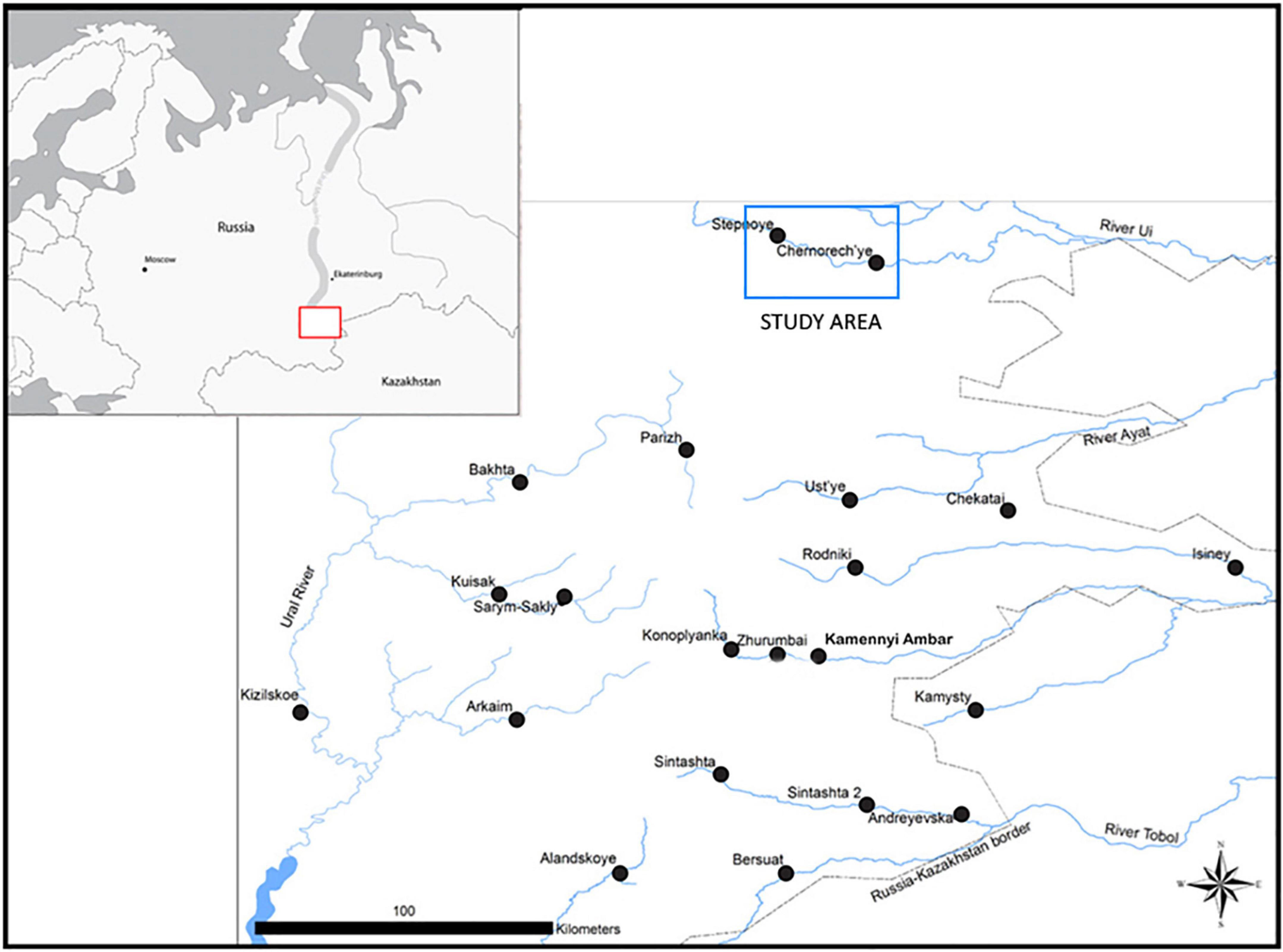
Figure 1. Map of enclosed Bronze Age settlements and Study area in the Southeastern Urals [modified from Doonan et al. (2014, p. 761)].
In 2009, SCARP started sampling flotation soil removed during stratigraphic excavation to investigate plant resource exploitation as part of the Bronze Age subsistence economy and to examine possible seasonal use patterns associated with plant resources and related activities at the Stepnoye settlement. The goal of the excavation was to further excavate and study the Sintashta -Petrovka period ‘house’ structure identified in 2008 and investigate anthropogenic activities outside the enclosed area of the settlement (Hanks and Johnson, 2012).
Based on the data from remote sensing, excavation, test pitting, and materials analysis, the excavation area in the Stepnoye settlement was constructed and functioned during the MBA Sintashta-Petrovka period. There is an extraordinarily large number of charred Fabaceae seeds from the Stepnoye excavation (Table 1). Several species from the Fabaceae family have been identified. Because of the poor preservation condition and morphological similarity, Medicago, Melilotus, and Trifolium genus were grouped in this project. The total number of identified Medicago/Melilotus/Trifolium spp. is 803, around 62% of the Fabaceae. According to the morphology, these species may be included Medicago falcata, Medicago lupulina, Medicago sativa, Melilotus wolgicus Poir., Trifolium arvense, Trifolium montanum, and Trifolium repens. The number of Vicia spp. is 384 around 31% of the Fabaceae. Most of the Vicia spp. identified in the Stepnoye settlement samples are probably Vicia cracca. Most of unidentified fragments appear to have some characteristics of the Fabaceae family (Medicago and Vicia spp.), but the characterized part for identification is missing among these seed fragments. Thus we just group it as unidentified. Fabaceae are valuable fodder plants that are utilized in the region now for livestock. The species mentioned above are typical plants representing the meadow zone environment along the Uy River valley where the Stepnoye settlement is located. The seeding season of these species is overlaid with the haymaking season in Southeastern Urals regions. Thus, the use and storage of green fodder or hay in the enclosed area may be related to the accumulation of Fabaceae and other meadow plants in the archaeobotanical samples. Fabaceae’s total numbers and percentages are dominant among seed assemblage in archaeobotanical samples.
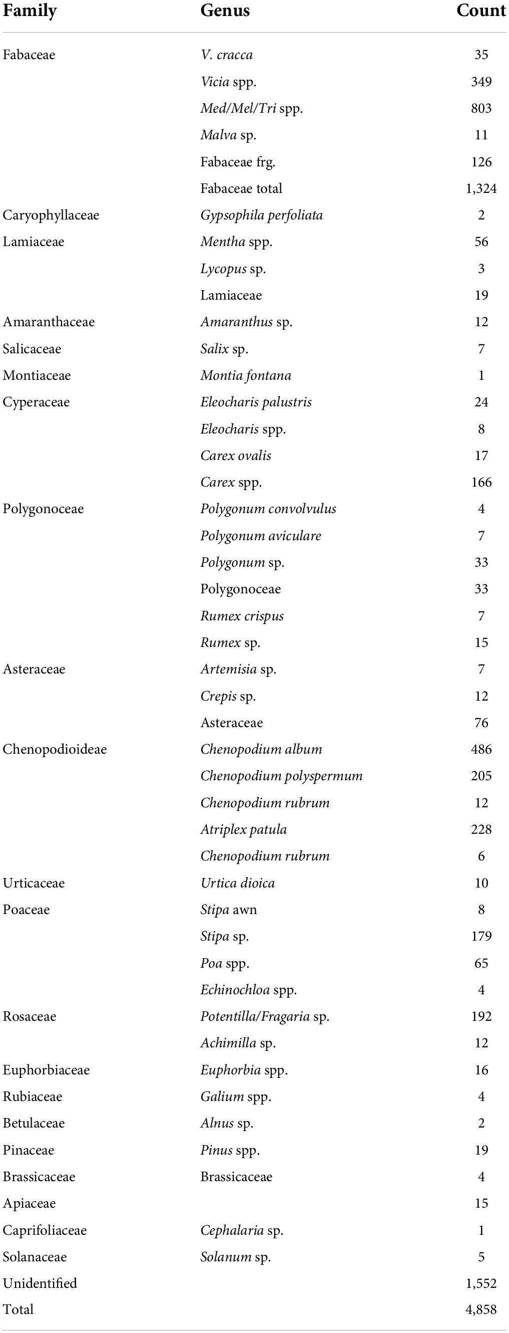
Table 1. The result of identifiable species in the botanical samples from stepnoye excavation 2008–2009.
The significant finding of archaeobotanical research in Stepnoye are (Ng, 2018):
(1) No domesticated seeds were recovered.
(2) Fabaceae family (Vicia spp., Medicago spp.) is the majority of archaeobotanical samples.
The archaeobotanical sampling associated with the excavation of the Stepnoye settlement indicated a significant pattern of local wild resource exploitation for humans and livestock. At the same time, the recovered macrobotanical remains from the Bronze Age Stepnoye settlement could be related to the identifiable contemporary flora within the Stepnoye catchment zones pasture. This result is similar to the Karagaily-Ayat valley in the same region, the combined analysis of plant macro-remains and pollen results show that the living environment of the Bronze Age vegetation was comparable with the current situation (Krause and Koryakova, 2013; Stobbe et al., 2015, 2016). Therefore, it suggested that catchment zone analysis and associated pasture mapping helped identify the Bronze Age plant resource exploitation strategy related to herding patterns (Ng, 2018).
The result of zooarchaeological analysis from the other two Sintashta-Petrovka sites (Ustye and Kamennyi Ambar) in the Southern Ural Mountains region suggests that cattle were dominated, sheep/goats were predominant, and horses were bred in small numbers (Table 2). Today, a group of livestock herd from the Stepnoye village is around 100 cattle, 10–20 horses, and the rest are sheep, resulting in a mixed herd of approximately 180 animals. The cattle were dominated in the herding composition of the Bronze Age and the current situation, which partly suggests ethnographic study can be collected as comparative data.

Table 2. The proportion of identifiable livestock bones within the faunal assemblage (Sintashta-Petrovka period) from Ustye (1984–1991) and Kamennyi Ambar excavation.
From the regional archaeobotanical and zooarchaeological results, we can see some characteristics related to recent vegetation zone and herding activity:
(1) Most of the plant species in the archaeobotanical samples are related to identifiable contemporary flora surrounding the Bronze Age Stepnoye settlements.
(2) Plant resources from the meadow zone are essential in recent herding activities. These species also dominated in the archaeobotanical samples. They can use/stored as fresh fodder and hay in the enclosed settlement.
(3) Cattle is dominated in the faunal remains. It is also the primary livestock in the recent herd in this region.
These characteristics suggest that recent ethnographic data can partly assist with the examination of Bronze Age pastoralist herding patterns. However, there are still missing links between the archeological record and available ethnographic data from the South Urals regions. In discussions on pastoralist subsistence economies, regional differentiation stands out within ethnographic data (Joseph and Mikhalev, 2005). For example, the hay yields can vary from 1,000 to 5,000 kg/ha from meadow zones due to the different plant species assemblage. And the differentiation can exist in a small area. In addition, environmental constrictions such as elevation boundaries, annual precipitation patterns, and vegetation unit distribution can affect pastoralist communities differently.
In comparison with previous research, ethnographic studies undertaken through the field research were primarily based on the analysis results of the archaeobotanical record recovered from the Bronze Age settlements within the local region. Thus, observations of foddering practices and livestock herding patterns in the local area provide an important form of actualistic study to examine and understand essential relationships between local wild flora resources (especially plant resources from meadow zones) and livestock herding patterns. Therefore, regional ethnographic study and pasture mapping (focus on meadow zones) in local catchment zone provide essential comparative data to interpret the herding-related plant remains and further discussion of herding patterns among Bronze Age pastoralist communities in this area.
Study area
The Southern Ural Mountains region is located in the north temperate zone between approximately 50 and 55° north latitude. It lies perpendicular to the direction of the predominantly westerly winds and the western slopes are more humid than the eastern slopes. The difference in precipitation is approximately 100–150 mm annually. The climate is moderately continental, with long cold and snowy winters, warm summers, and clear transitional periods in the spring and autumn. The precipitation in the peneplain areas reaches 400–500 mm during warm seasons and about 500–600 mm during the entire year (Koryakova and Epimakhov, 2007). The annual average for snowfall is 24–30 cm, and it usually snows for 153–155 days per year (Levit and Mironycheva-Tokareva, 2005). The whole region is made up of forests, forest steppes, and dry steppes. In the north part, there are many sizeable developed river networks. These river valleys provided rich biological resources and vegetation in the summer for late prehistoric human and animal populations. The Ural and the Tobol are the two major rivers in the southern Trans-Urals that form the watershed and landscapes. The interfluve is shaped by the beds of smaller tributaries that flow either west toward the Ural or east toward the Tobol. The largest water source is annual precipitation, which provides 80–90% of the rivers’ volume (Levit and Mironycheva-Tokareva, 2005). For this reason, water flows at low speed (0.1 m per second and up to 2 m per second in rapids) during the dry summer months, but in the flood period, the volume increases sharply, and the level rises 1–2 m (Levit and Mironycheva-Tokareva, 2005).
The climate pattern in the region essentially conditioned the type of pastoralist herding patterns that developed here. In summer, the size of the meadow zone is maximized because of the sufficient water supply. Thus, outdoor herding activities and haymaking processes are usually scheduled from May to August in the summer. However, since the water sources of the rivers depend largely on annual precipitation, the size of the different vegetation zones (especially the meadow zone) varies substantially from year to year.
Uy River Valley has situated in the steppe zone of the Southeast Urals region. Since the Soviet period, agriculture and herding have been major economic activities in this valley. The scale of herding activities was more extensive in the Soviet period, but it declined since the local village’s population decreased. The surrounding village areas along the river were used as agricultural fields in the Soviet period, but many fields have been abandoned in the last 20–30 years. These areas are used today as rangeland or haymaking zone for herding activities. Agricultural fields are usually farther away from the village and higher elevations to prevent flooding. Based on the observation from 2009 to 2018, the contemporary vegetation zones around stepnoye village are relatively stable. Some artificial lakes are formed in Uy River Valley by blocking dams on streams. These lakes are seasonal and usually small (around 1 ha).
The Stepnoye settlement is situated along the Northern bank of the Uy River. This settlement is associated with one of the region’s most significant Bronze Age cemetery complexes (Stepnoye I; Stepnoye VII) and includes at least 45 kurgans (barrows) dating from the Middle to Late Bronze Age. Moreover, another Sintashta-Petrovka settlement (Chernorech’ye), and associated cemetery (Kryve Ozero), are located 20 km downstream and to the southeast of Stepnoye (Figure 2). The Stepnoye settlement is enclosed by a rectangular ditch and bank complex, with 43 internal linear depressions ranging from 6 m × 2 m to 10 m × 15 m (Figure 3). These have been interpreted through aerial photo analysis as individual domestic house units (Zdanovich and Batanina, 2007). The analysis of the archaeobotanical samples from the Stepnoye settlement, combined with the catchment zone analysis, provides substantial empirical evidence for understanding usage patterns for all the local ecological zones within the catchment. The meadow zone provided crucial resources for the ancient pastoralist communities as it does today for local livestock herding, grazing, and foddering (Table 3). This zone provides the most valuable pasture area within the catchment and is also very useful in terms of plant resources that human populations may have utilized (Ng, 2018). The forest zone was an essential resource for fuel and building materials collection. The forest and meadow zones were also essential for other plant resource exploitation. Besides these two vital zones, the Bronze Age communities selectively used some plant resources in different ecological zones. These resources’ choices and usage rates probably relied heavily on the local microenvironmental settings (Rühl et al., 2015; Stobbe et al., 2016; Ng, 2018).
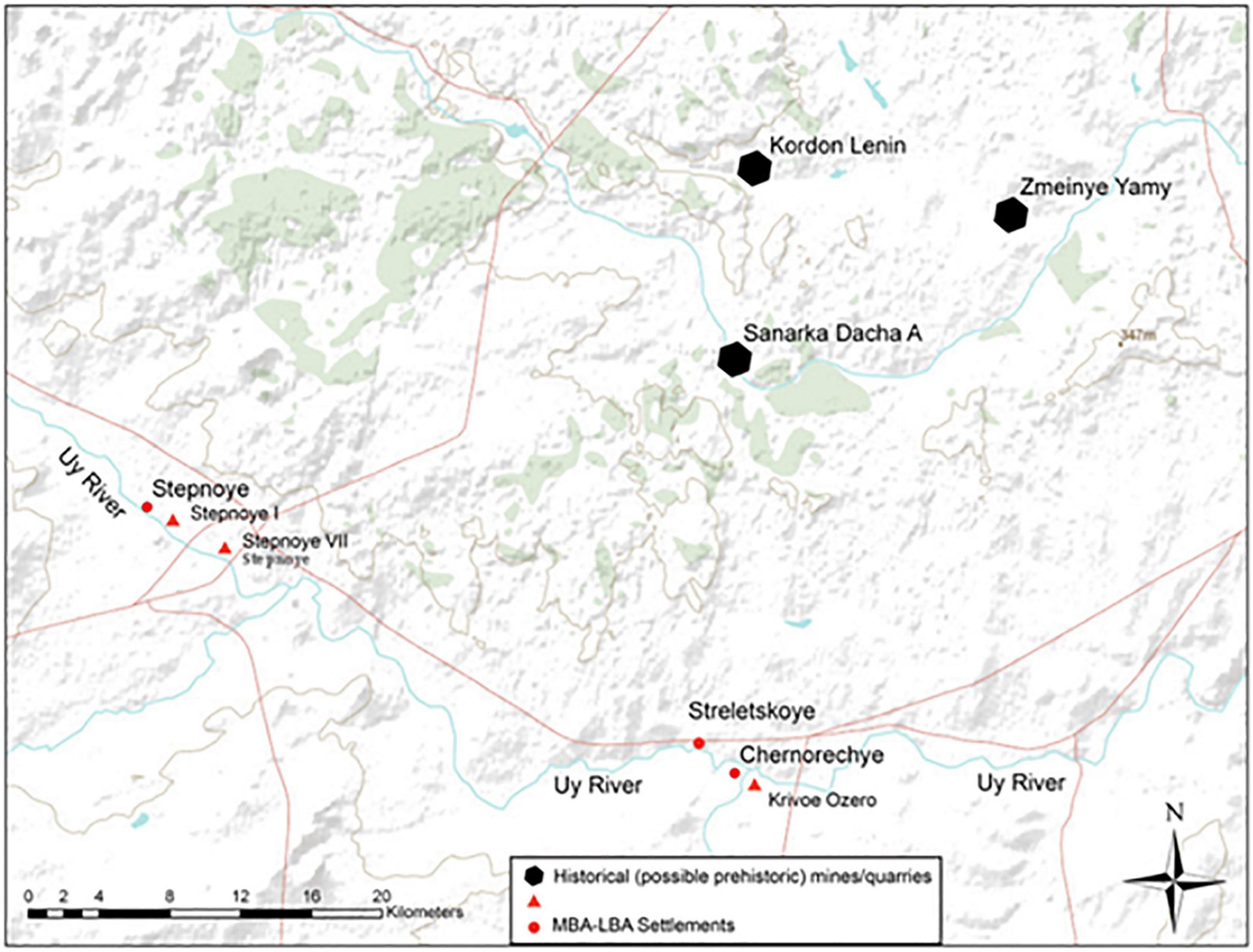
Figure 2. Map of Uy River valley showing key Bronze Age sites [modified from Doonan et al. (2013)].
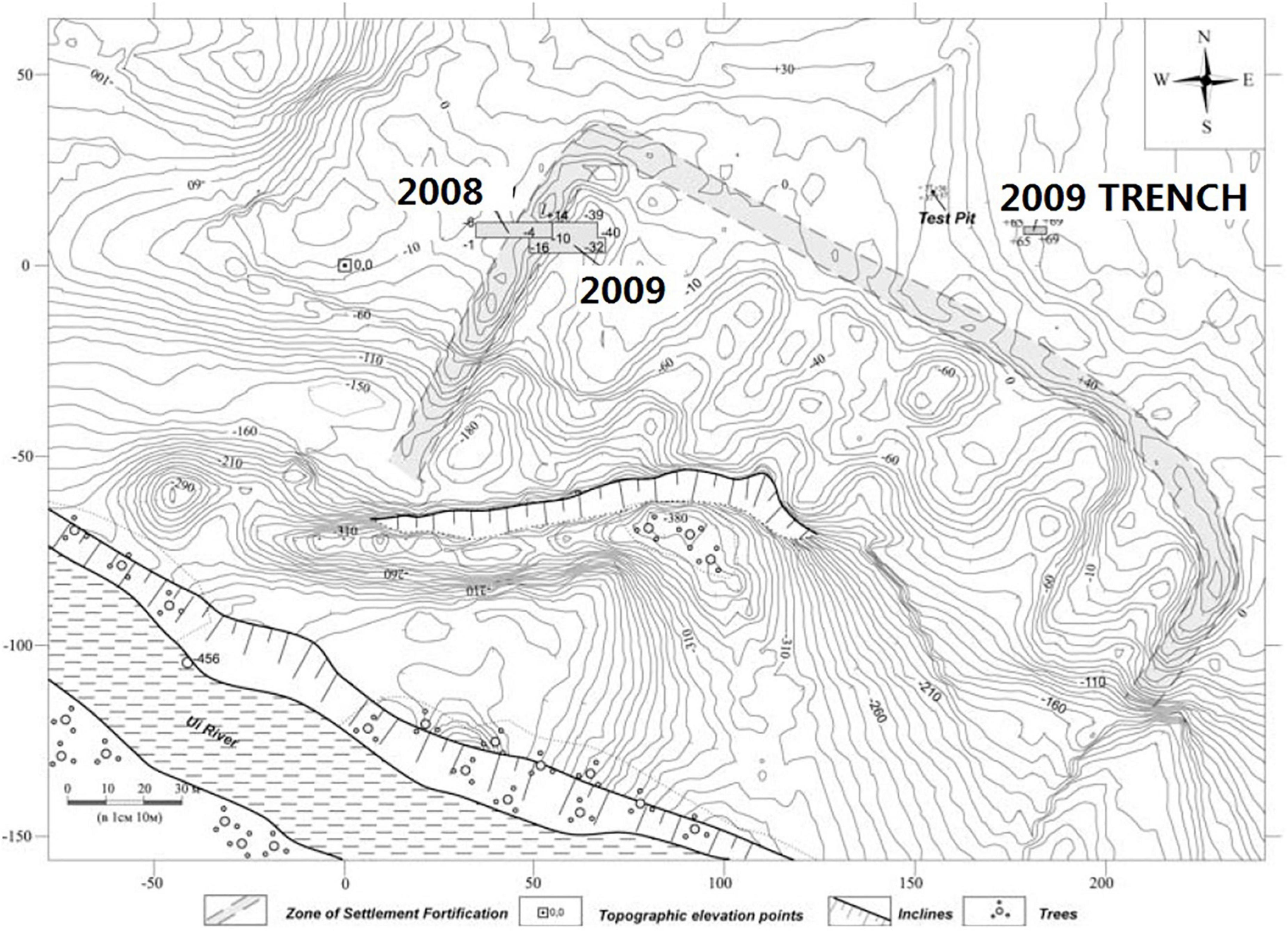
Figure 3. Images of the Stepnoye settlement: lower–topographic plan showing excavation units (after Hanks and Johnson, 2012).
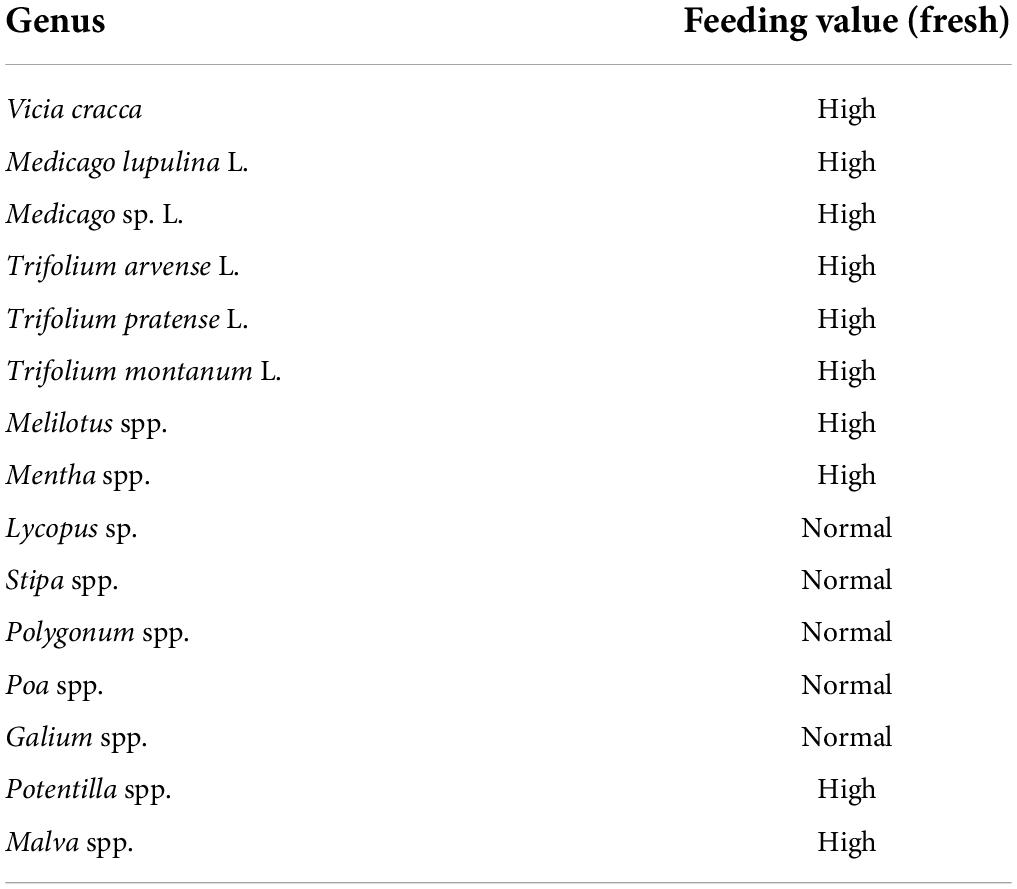
Table 3. potential forage plants in meadow zones are represented in the archaeobotanical samples with the indication of value.
Materials and methods
Ethnographic study
The ethnographic study included observing daily herding activities and interviews with the local herders. As a reliable regional dataset, ethnographic data was collected in Uy River Valley over several seasons. It helps understand the seasonal environmental change, distribution, and variability of essential plant resources. Also, these interviews provided important information on the personal decisions and annual schedules of local herders in the region. At the same time, we observed the local herding patterns and recorded the herd sizes and compositions in different seasons. From these observations, we could identify several specific variables that constrained herding practices, and by observing the local herders’ daily strategies, we could identify their solutions to these challenges.
Compared with the Bronze Age microenvironment, intensified agriculture partly changed the landscape since the Soviet period in the Uy River Valley. However, recent agricultural field locations (usually in higher elevations not close to rivers) and increased abandoned fields due to the local village’s decreased population, the survey area’s landscape, vegetation zone (especially the meadow zone), and plant communities have been relatively stable these years. Only one small artificial lake (around 1 ha) was formed by blocking the stream in the survey area. An artificial lake can extend the surrounding meadow zones, increase the pasture capacity and change the herding route. In this study, Compared with the size of the survey area (5 km radius), the effect of the lake was probably minor.
Pasture mapping
The archaeobotanical samples collected from the ancient Stepnoye settlement suggest the intensive exploitation of plant resources in the meadow zone instead of other ecological zones. Therefore, the pasture mapping focus on the meadow zone within the Uy River valley. The growth of the meadow zone heavily relies on water resources and precipitation in the rainy season. The rainy season in July and August is essential to open rangeland herding season and haymaking process. In this area, the number of livestock is usually the highest during the open rangeland herding season. And the haymaking process will also focus on these 2 months and end before September. Thus, this study focuses on these 2 months to estimate the potential pasture for herding activities in the survey area.
First, We use the Normalized Difference Vegetation Index (NDVI) to estimate the pasture capacity in the survey area. NDVI is a method for vegetation monitoring since Rouse developed it in 1972 (Rouse, 1972). This method depends on the difference between the healthy green vegetation and other land surface reflectance (including unhealthy/dry vegetation) in red and infrared wavelengths (Rhew et al., 2011). The underlying principle of the NDVI is that healthy green vegetation reflects more infrared radiation and absorbs more energy in the red wavelength when compared with damaged vegetation surfaces (Rhew et al., 2011). Therefore, the NDVI value is defined by the ratio of:
NIR is the near-infrared wavelength reflectance, and RED is the reflectance in the red wavelength. The resulting values range from −1 to 1, where −1 indicates no vegetation presence, and 1 shows dense levels of healthy vegetation (Rhew et al., 2011). NDVI values are used in other archeological projects to identify seasonally grazing ground (Caspari et al., 2017; Jia et al., 2020). In this study, we use it to estimate the potential pasture capacity during the survey period in 2017.
Then, we pursued a pedestrian survey along the edge of the meadow zone and collected GPS points. After that, we digitized the general distribution of the meadow zones and estimated the potential grazing capacity within these areas as defined by a catchment zone of a 5 km radius. The pedestrian survey was conducted during the summer of 2017. The summer season provides the highest grazing capacity within the catchment zone. In total, we collected 120 GPS points during the pedestrian survey. After analyzing the GPS points, it was possible to more accurately sketch the extent of the meadow zone within the Uy River valley.
Results
Ethnographic study
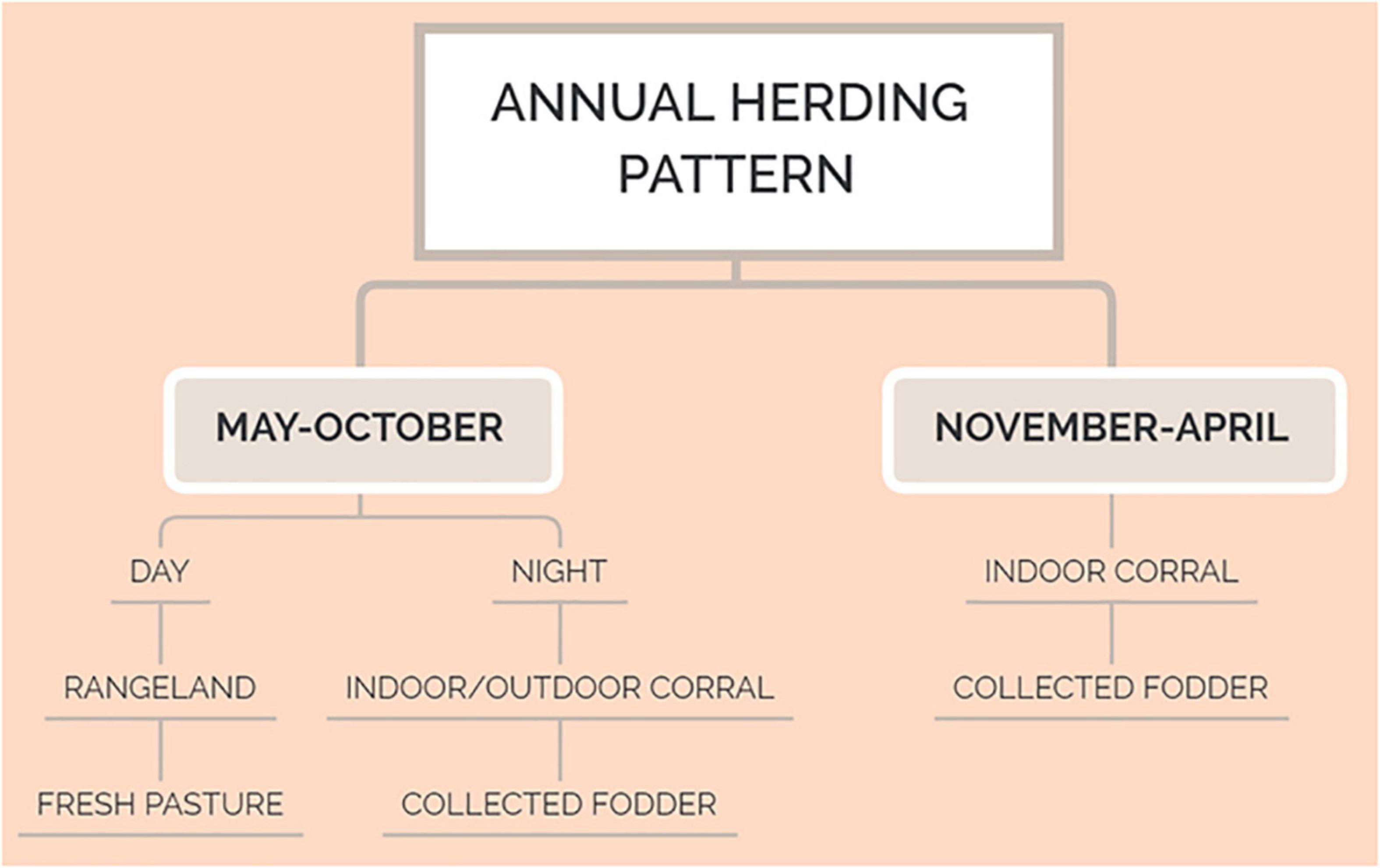
The ethnographic study focused on the Modern Stepnoye village, located along the Uy River valley and 2.5 km east of the Bronze Age Stepnoye settlement. Generally, the time of the indoor corral season (November–April) and open rangeland herding season (May–October) varies due to annual snowfall. The major differences are the sources of fodder and the location of herding and grazing activities. During the indoor corral season, livestock is fed with harvested wild grass hay (fodder). During the rangeland herding season, livestock will graze within the open rangeland areas during the day and then be returned to the villages for the night. They are either kept in indoor or outdoor corrals and fed with collected fresh fodder at night. The general annual herding pattern of the Southeastern Urals region is presented in Figure 4.
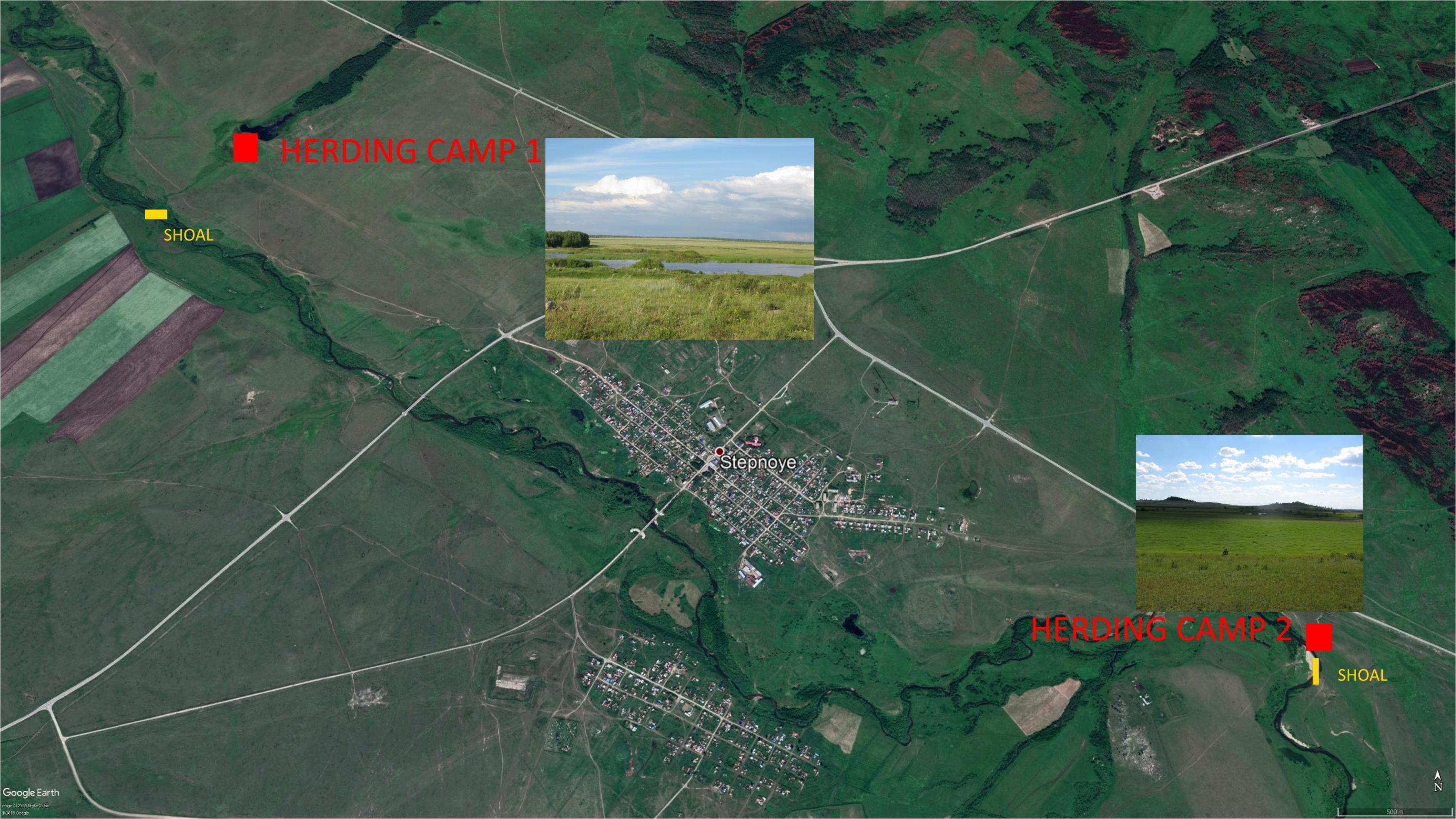
There were two herding camps used during 2017. The location of the herding camps is shown in Figure 5. The herding camps typically have a small shelter that may be used as a convenient place for the herders to rest, eat, and take shelter during rain storms and the daily activity of managing the cattle herds. However, these sites are not used every day. The actual open rangeland is the surrounding areas around the camps.
Herding camp 1 is situated 2.5 km northwest of the modern Stepnoye village (Figure 5). This location is adjacent to an artificial pond with a large surrounding area with meadow zones for grazing. This location is elevated above the river’s riparian zone and allows the herder to monitor the livestock easily. Usually, the herding season begins in the spring and lasts until the first snows in late fall.
Herding camp 2 is 2.08 km away from the eastern edge of the Stepnoye village (Figure 5). This camp is situated in a large meadow zone along the Uy River, and there is a river ford nearby allows for the movement of livestock from one side of the river to the other. The daily herding schedule for this camp is similar to Camp 1. The herd size is around 160, with around 150 cattle and the rest horses. During heavy rain, livestock will shelter in the tall vegetation within the riparian zone located near the camp. The camp is situated very close to a modern road, but the herder never crosses this road to graze the animals there.
The livestock herd in both camps is an aggregate of animals owned by different families in the village. These families hire a full-time herder to manage the livestock. The herder starts work at 7 am, and after picking up the livestock from different families, he moves them out of the village around 8 am. The actual time varies somewhat due to weather conditions. The daily herding activity can last for around 10 h, and after 6 pm, the herder moves the livestock back to the village. By 8 pm, the owners had collected most of the livestock.
There are occasions with the herder that may change the specific camp, and associated grazing zone, that he uses. The decision typically depends on the grazing rate in the surrounding area and the route he uses to move the livestock. In addition to the rangeland surrounding the herding camps, the herders push the livestock through the meadow zones adjacent to the main river course. The meadow zones on the opposite side of the river can be accessed by the shoals (fords) to cross the river, which is usually 500 m from the herding camps. On heavy rainy days, the herder will move the livestock to the forest or the riparian zone as shelter. These areas are usually closed to the livestock grazing area.
During the Soviet period, the number of livestock is much higher than today because of the higher population number in the local village and government policy. The herding pattern resembles a commercial livestock farm in some recent local villages. Usually, these companies will manage most of the livestock from several close by villages. Cattle are dominated in livestock composition by over 70%. The time of the indoor corral season (November–April) and open rangeland herding season (May–October) varies due to annual snowfall. The commercial farm will set more herding camps far away from each other. And during haymaking season, they need to input more labor force and machines for the vast amount of winter hay requirements. Nevertheless, the general principle is similar to regular herding activity:
(1) Herding camp is close to water resources and meadow zones.
(2) The herding route is along the water resource and covered meadow zones.
(3) Rangeland is separate from the haymaking area to ensure the collecting rate of fresh hay.
(4) The haymaking season is similar to the regular herding activity after the rainy season.
In Southeastern Ural, the number of cattle on some commercial farms can be up to 8,000. But it is risky to lose cattle in Winter because of a lack of hay.
Pasture mapping
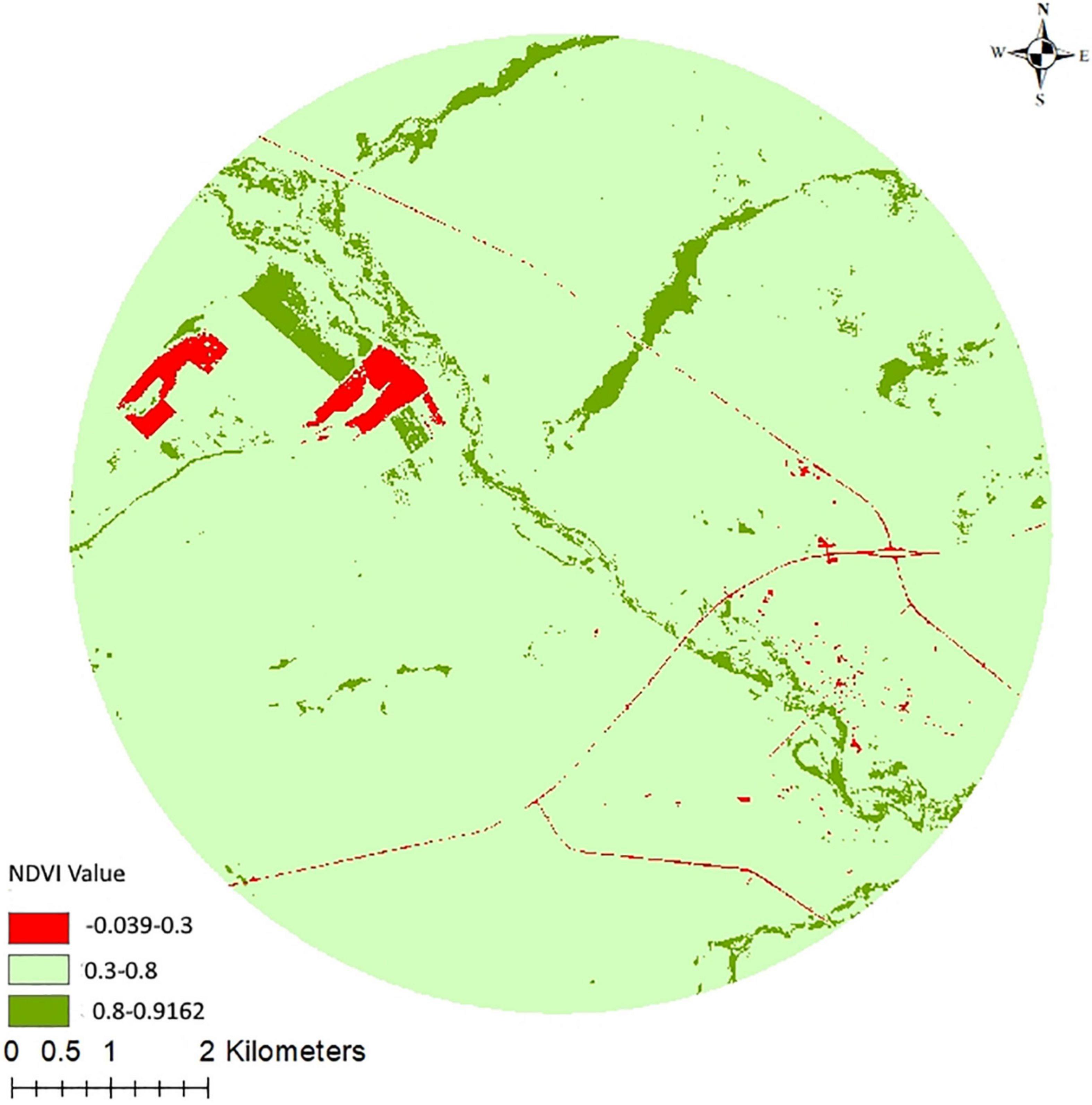
We acquired 2 Sentinel-2 images on July 14 and August 06 during the survey period in 2017 (ESA, 2017). July and August are rainy seasons in this area. They are also crucial for herding activities and haymaking season. After ArcGIS software processing, we restored the potential fresh pasture (NDVI value 0.3–0.8) in a 5 km survey area (Figure 6). The estimated size of the potential pasture field from NDVI value in July and August is over 7,000 ha (Table 4). The distinction between meadow and other vegetation zones is difficult through NDVI value in the survey area. After we changed the NDVI value (0.3–0.5) representing the potential pasture field, the number of pastures field (over 3,500 ha) was still very high compared with the observation. Thus, we pursued a more detailed pedestrian survey to estimate the size of the meadow zone.

Table 4. The estimation of the potential rangeland in a 5 km radius survey area around the Bronze Age Stepnoye settlements in July and August 2017.
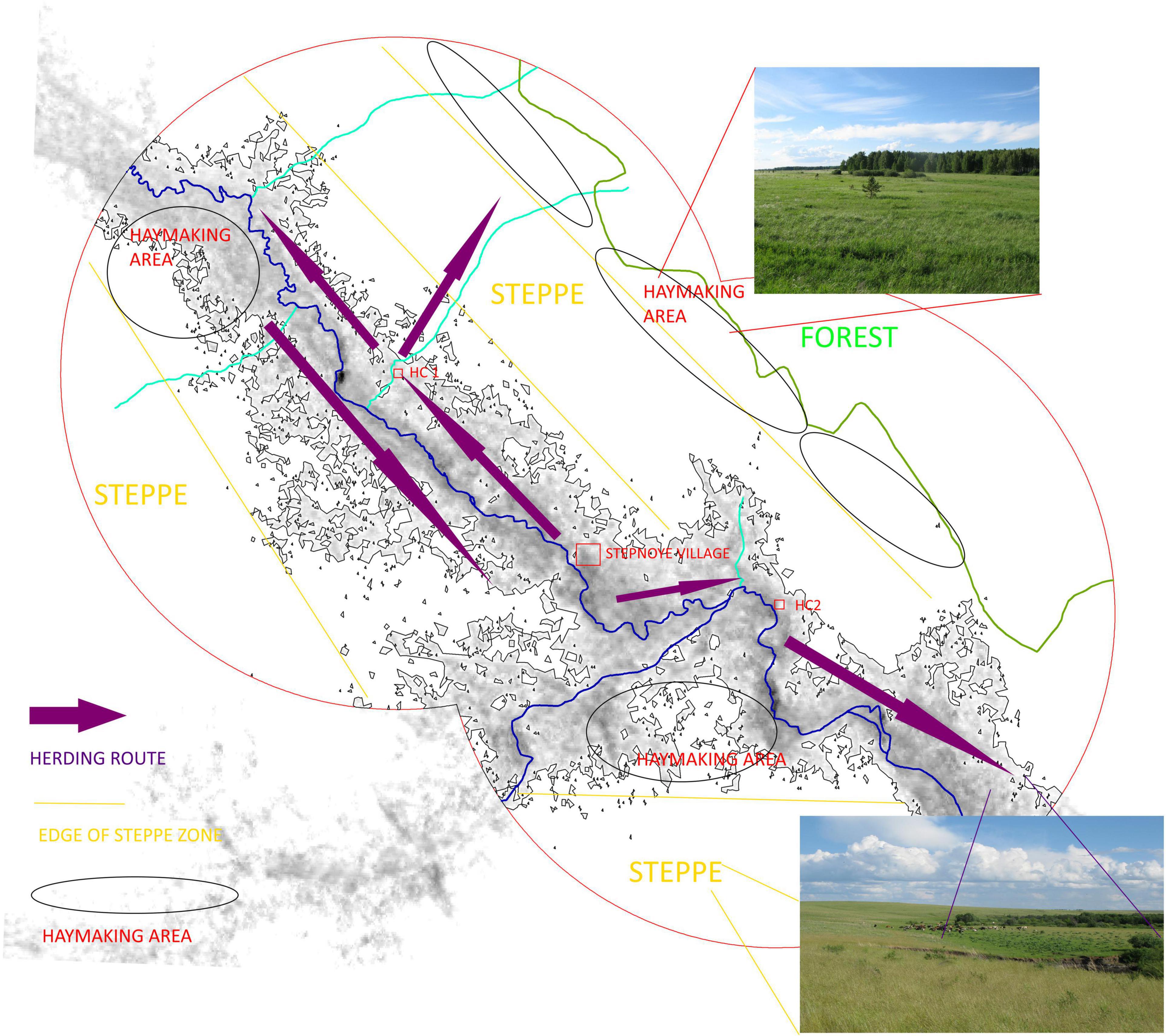
The pedestrian survey was undertaken within a 10 km radius around the Bronze Age Stepnoye settlement. This work was carried out in July and August. The potential size of the meadow zones is enormous during these 2 months because of high precipitation. It is also essential for grazing and haymaking season in this region. Thus, we can observe how local herding patterns are related to the distribution of meadow zones. Four main types of meadow zones were identified (Figure 7):
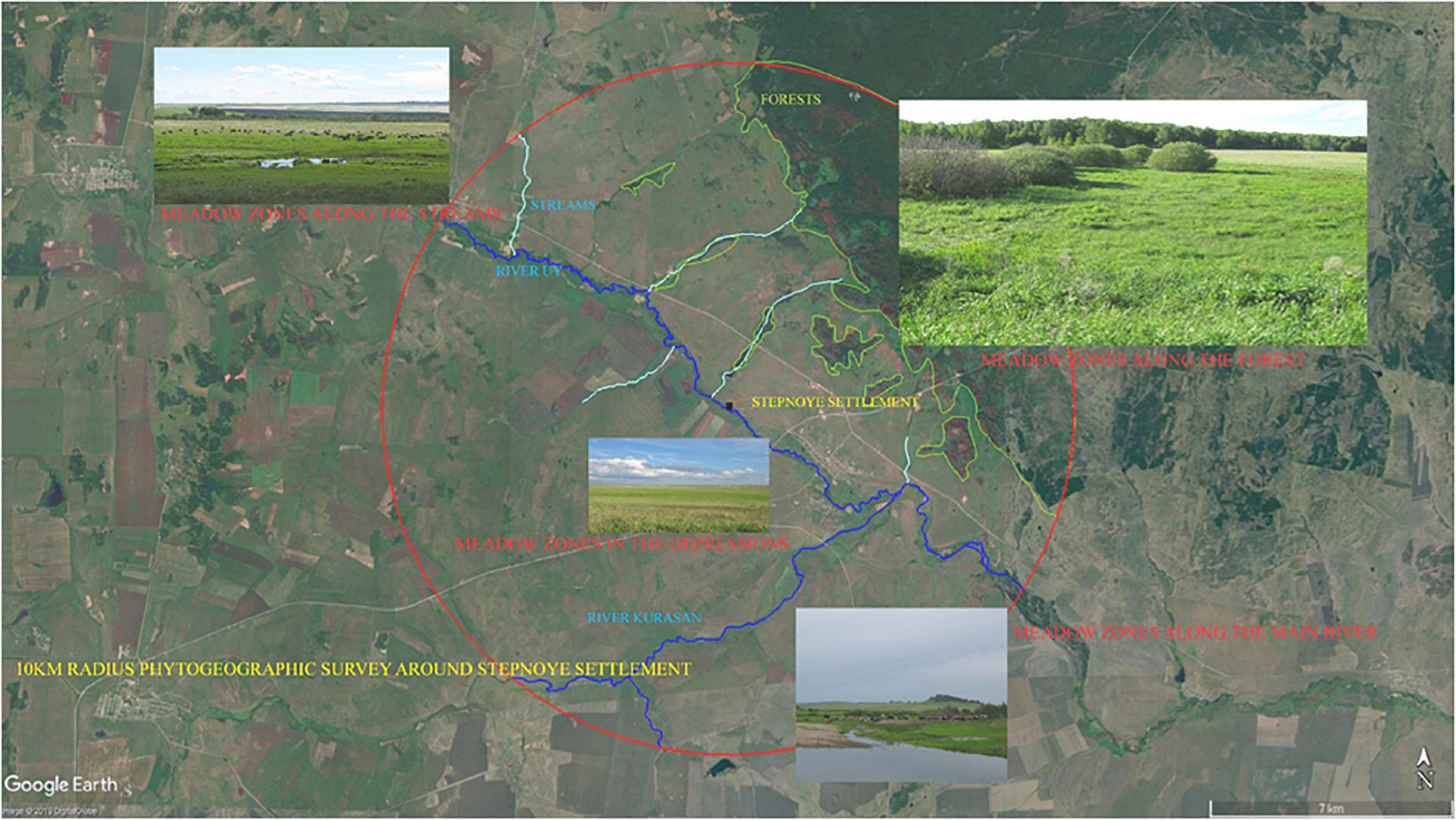
Figure 7. Satellite image and photos denoting phytogeographical survey zone, associated meadow zones, and location of the Stepnoye Bronze Age settlement.
(1) Year-long Meadow zones along the Uy and Kurasan rivers.
(2) Year-long Meadow zones along the seasonal streams.
(3) Year-long Meadow zones along the edge of the forest.
(4) Seasonal Meadow zones formed in the depression areas during the rainy season.
The meadow zone is typically a continuous belt zone adjacent to the main river, especially in lower elevation areas. In the survey area, most meadow zones are continuous large patches along the Uy River. The width of this zone varies from 300 to 550 m. It mainly depends on the river’s water supply (e.g., flooding, subsurface water and proximity to the water table, rainwater collection during heavy precipitation, etc.). By observation the most significant meadow patches usually form where the river is most comprehensive, and the overall landscape elevation is lower.
Besides the meadow zones along the river, there are also small meadow zones that form along the small streams that are tributaries to the main Uy River. These small streams are usually formed from springs with consistent flows seasonally. In Figure 8, it is possible to note that these streams usually flow from the forests (higher elevation upland zones) to the main Uy River. These bisect the steppe and meadow zones that run broadly parallel to the main river course. The width of the meadow zone along the streams flowing into the Uy River varies from 100 to 200 m. In the rainy season, meadows also form in some low elevation depressions within the steppe zone. These depressions hold moisture following rainy periods. Therefore, the area surrounding these depressions will slowly change to steppe vegetation when the water in the depressions evaporates. The vegetation size also increases in the center of the depressions until the moisture has evaporated. Therefore, the size of the meadow vegetation around these depressions is unstable, and because of this fluctuation, local herders do not consider them significant grazing resources. However, livestock lingers in these locations as they pass through them toward the more prosperous meadow zones.

Figure 8. (Left) Image indicates the extended meadow zones along the main rivers in the 5 km radius survey area. (Right) Image indicates the extended meadow zones along the streams in the 5 km radius survey area.
During the survey, we also found meadow zone areas at the edge of the forests. Usually, the forest is located at some distance from the main river. For example, the Bronze Age Stepnoye settlement is today located approximately 5 km away from a forest zone. The growth of the meadow vegetation adjacent to the forest is also related to water supply (soil moisture) and local soils. The location of the forests is generally associated with higher elevation areas, which receive more snowfall during the Winter and early spring, and have sources of underground water (springs). In addition, the soil nutrients are usually higher in the forest zone because of the humus formation.
It is difficult for the meadow vegetation to grow in the forest zone because of competition with the abundant woody plant species. However, a narrow belt of meadow vegetation is typically formed on the edge of the forest and the steppe zone. Usually, the width of this meadow belt can expand up to 30 meters. Local herders usually gather and dry fodder from these locations. The drier and less productive steppe zone separates this belt from the summer herding zone along the main river and its tributaries. As a result, livestock does not disturb the vegetation in these areas, and the vegetation size is relatively stable even in years with low precipitation.
Meadow vegetation also forms on the slopes of the upper elevations hills away from the main river course. However, through our observations, we found that local herders never utilize these resources for two main reasons:
(1) These places are usually too far away from the herding camps and settlements,
(2) The landscape between these locations is typically covered by steppe grazes and contains no livestock water resources.
As a result, the cost-efficiency of herding in these locations is very low compared with the meadow zones next to the consistent sources of water along the main river, its tributaries, and the minor season streams that flow into it.
Many environmental factors separate the meadow zones, and rivers, streams, and other ecological zones contribute to these factors. Based on the survey results, elevation is a critical factor in determining the formation of meadow zones along the main river. Most of the GPS points taken during the survey indicated elevations between 255 and 270 m above sea level. However, the elevation difference in the same meadow zone was usually less than 10 m. It is, therefore, possible to see a clear elevation separation between the meadow and steppe zones. Sometimes the distance from the river is not the only factor influencing vegetation growth, as some river bank areas are much higher than the water surface. As a result, one can only find steppe vegetation growth in these locations.
During the survey, I noted that many meadow zones were distributed throughout the catchment zone. But some of these meadow zones were seasonal and only existed during the rainy season. Thus, there are two basic ways to exploit the meadow zones for pastoralism:
(1) Those locations representing year-long meadow zone growth within the catchment,
(2) Locations with lower elevations promote the formation of only temporary meadow zones within the catchment.
One of the present-day herding camps is situated approximately 1 km from the Bronze Age Stepnoye settlement. This camp is located next to an artificial pond created on a small stream that flows from the upland forest zone 5 km to the north. The distance to the main Uy River is around 1 km. This herding area offers year-long meadow vegetation associated with the pond, river, and stream. Also, there are many depression areas surrounding the herding camp that also offer seasonal meadow resources. Overall, the size of the combined meadow zones is relatively stable in this specific area. Undoubtedly, the Bronze Age vegetation is somewhat different from the modern vegetation because of the nature of human activities during the contemporary era. However, the survey results still provide essential information about the formation and distribution of meadow zones in the catchment zone. The logic of maximizing the exploitation of these naturally occurring meadow zones within the local landscape may have been similar during the Bronze Age.
As discussed above, the survey area covered a 10 km radius around the ancient Stepnoye settlement. From observing local herders, the actual herding distance is much less than 10 km. The limiting factors in selecting grazing areas is also related to the proximity of sufficient water resources and the time it takes to move a herd during a single day (Dahl and Hjort, 1976; Asanov et al., 1994; Coppolillo, 2000). Therefore, based on my observations of local herding within the catchment of the Stepnoye village today, the full radius was reduced to around 5 km. The catchment zone of the Stepnoye Bronze Age settlement is relatively flat. Thus, the variance between distances shown on the maps that have been produced and the actual walking distance and time of travel is slight. In the 5 km radius catchment zone around the ancient Stepnoye settlement, the critical meadow zones are along with the Uy and Kurasan River tributary, small streams flowing into the Uy River (as discussed above), and the edge of the forest zone to the north of the settlement. The small rainy season meadow zones related to the depressions in the landscape were recorded during the pedestrian survey. So estimations of the resource value of the small catchment are based on detailed data from the pedestrian survey.
The estimated size of the meadow zones along the river and streams is based on the width (minimum/maximum) of the meadow zone measured during the survey. The size of the potential depression is the area covered by associated elevations (255–275 m) minus the area of the year-round meadow zone. Because these meadow zones formed in depressions with only seasonal meadow-type growth during the rainy season, the estimation of the area size was calculated for 1 month only. The results of these estimations zone are shown in Figures 8, 9 and Table 5.
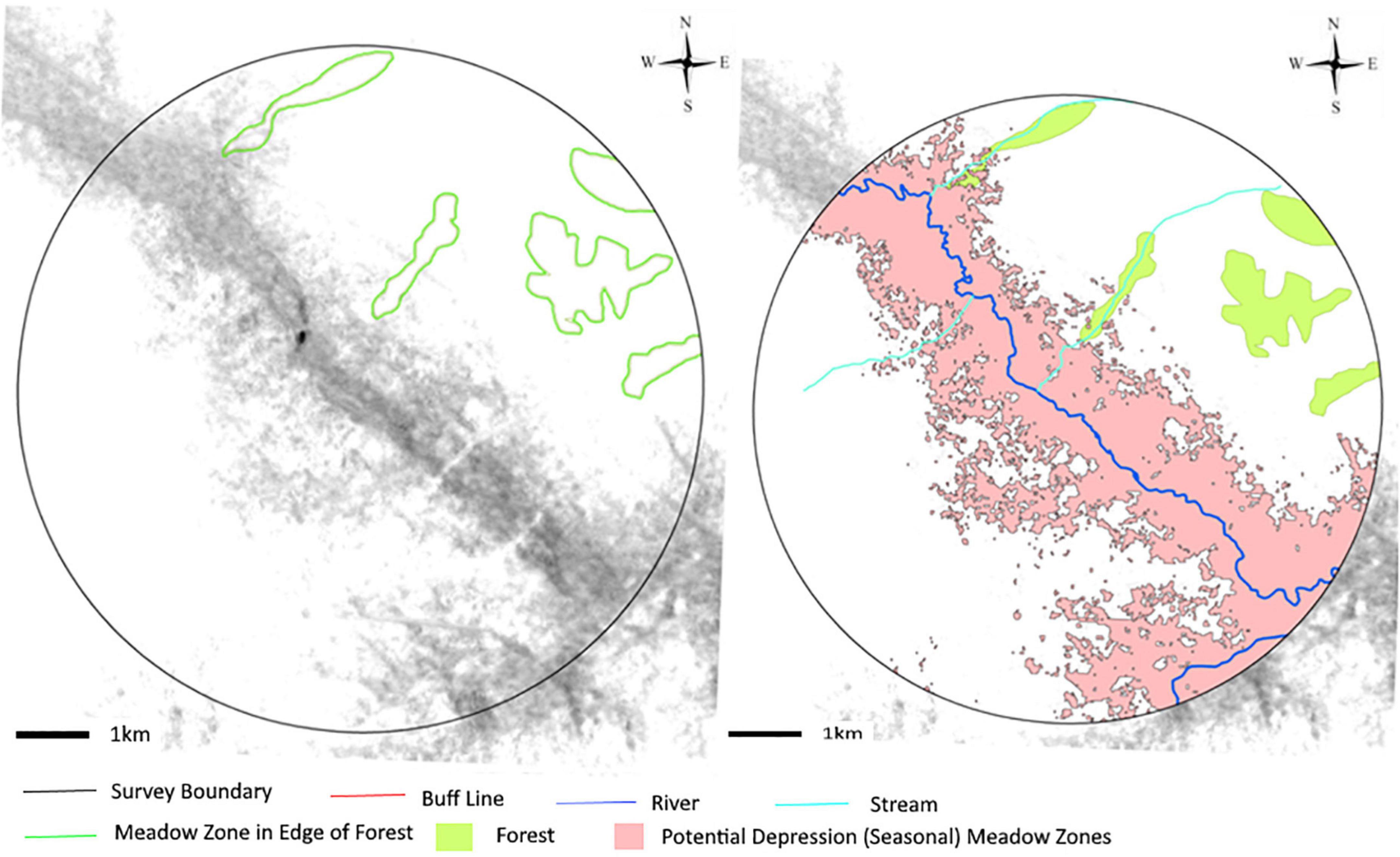
Figure 9. (Left) Image showing the extended meadow zones along the forest in the 5 km radius survey area. (Right) Image showing the location of rivers, streams, forests, and the potential depression (seasonal) meadow zones within the 5 km radius survey area.

Table 5. The estimation of the Meadow zones in a 5 km radius survey area around the Bronze Age Stepnoye settlement in 2017.
The estimated area of the year-long meadow zones in the catchment zone ranges from 1,314 (with a minimum buffer zone of rivers and streams) to 2,351 ha (with a maximum buffer zone of rivers and streams). This number is relatively high when compared with the estimation of other settlements in the Southeastern Urals region (Stobbe et al., 2016). However, the size of the meadows can have a high inter-annual fluctuation because of the variability and timing of precipitation.
This estimation is also combined with additional comparative data (Yanguzin, 2002; Frachetti, 2008; Stobbe et al., 2016). The estimate of grazing capacity, therefore, is based on the unit productivity of meadow zones [8 tons (1,000 kg)/ha fresh pasture] mentioned discussed by Stobbe et al. (2016). Assuming this is a year-round grazing pattern, the whole fresh pasture is estimated to be between 10,512 and 18,808 t.
Discussion
Herding pattern
The result of the ethnographic study suggests that some basic rules structured the herding activities around the Stepnoye village (Figure 10).
First, the livestock grazing areas typically avoid the zones where haymaking is carried out. As a result, daily grazing activities are closer to the main village, and the haymaking locations are usually further away from the herding camps and often separated by another ecological zone.
Second, the herding route is always along paths that are well supplied with water (main river or its tributaries). For example, from the Stepnoye village to Herding Camp 1, the shortest route is to cross the steppe zone. However, this route is never used. Instead, the herder will move the livestock along the river or stream toward the herding camp. It is the same for Herding Camp 2 in which the herding route also follows the river without any shortcut being taken.
Third, the highest priority for the rangeland is always the meadow zone. The herder may stop in the steppe zone during the spring and early summer. However, after the ripening of the Stipa sp. the herding route will avoid this zone.
Fourth, the distance between the herding camps and the Stepnoye village is less than 4 km. According to ethnographic studies in Africa, adult cattle’s mean daily herding distance can be up to 20 km (Fratkin et al., 1994; Homewood, 2009; Bollig et al., 2013). The daily herding distances at Stepnoye were much less and generally occurred within a 5 km radius of the village. The herding route ensured that the livestock was well watered and was not stressed by being pushed farther away. In addition, the rich meadow zones provided ample vegetation for grazing within the defined catchment.
Fifth, the choice of herding is strongly influenced by the surrounding vegetation, distance to easily accessible water resources, and elevation. One major limitation to the location of rangeland is the distance to water, which should not exceed 8 km for cattle or 4 km for sheep (Dahl and Hjort, 1976). Thus, both herding camps are located next to consistent water resources. In addition, the higher elevation of the camps provides better visibility for watching over the herds while they are grazing. As discussed above, the best ecological zones for grazing livestock are the meadows and the rangeland surrounding the two camps containing a significant proportion of meadow vegetation. And, also as noted above, they offer areas where fording the river is relatively easy.
The best choice of herding camp and its route can increase the livestock’s quality and rate of forage intake. Forage intake is crucial to determining successful herding activity. The herding camps associated with the Stepnoye village are in perfect locations within the catchment zone. The pattern of Bronze Age herding activities within a similar environmental setting may be relatively identical today. Thus, modern herding practices’ basic rules can aid in understanding Bronze Age herding patterns.
Pasture and carrying capacity
The ethnographic study also stimulated two essential questions:
(1) How vital was the meadow zone in the Bronze Age herding pattern?
(2) Did the utilization of other ecological zones result from inadequate resources, or does this reflect a simple matter of choice and preference to supplement the herding pattern?
Stobbe et al. (2016) has suggested two models that may help address these questions. Model A calculates the catchment zone’s biomass production and grazing capacity and determines the number of animals that can be supported throughout the year. Model B is based on the number of house units in the settlement, the estimation of livestock associated with these households, and the size of the potential herd of the Bronze Age communities occupying these settlements.
In Model A, the catchment size is fixed to a 4 km radius. Stobbe utilized GIS software to identify the size of the different ecological zones within the catchment. Finally, she used the average estimated productivity of the steppe zone and meadow steppe to calculate the grazing potential. In Model B, the result suggested estimating the total population per house unit (up to 10) with around 1,000 livestock from 41 house units in Kamennyi Ambar settlements. There was no danger of overgrazing within the catchment zone. Stobbe generally suggests that a year-round grazing pattern was possible in the local catchment during the Bronze Age. However, fresh or dried fodder may have been prepared for weak animals or during the harshest Winter.
Sharapov (2017) has recently calculated the size of the catchment zone for the MBA population associated with the Zingeyka valley at a 7.5 km in radius. His method combined Stobbe’s Model A and Model B. He suggested that the herding pattern of the Bronze Age was similar to the Eurasian extensive pastoralist tradition that relied on very little to no use of prepared fodder. In this model, the vast majority of livestock were kept outside year-round (Yanguzin, 2002; Masanov, 2011) and corrals were often associated with households for the livestock.
Other scholars have underscored the importance of the seasonal fluctuation of grazing capacity and that pasture productivity from spring to winter can vary from 750 to 263 kg/ha (Sobolev, 1960; Levit and Mironycheva-Tokareva, 2005). The winter season in the South Urals region is very long and snowfall can last from 5 to 6 months. Therefore, cattle and sheep are kept close to houses within corrals and covered structures. Only horses are herded outside the village in winter. This minimization of risk method is still essential for local herder today. Many families in modern villages have two cows. With the assistance of mechanized machinery, it is possible to collect enough winter fodder during a single summer month. The archaeobotanical samples collected from the ancient Stepnoye settlement suggest the intensive exploitation of plant resources in the meadow zone instead of other ecological zones.
According to the settlement plan, following air photo interpretations, the maximum number of dwellings at this site was approximately 50 (Zdanovich and Batanina, 2007). Therefore, if we use the herd structure for an average 18th-century Bashkir household (10 people/per household) as an analogy, the meadow zone in the 5 km survey area would support 60–109 families.
It is also essential to utilizing the person per household estimates suggested for the Middle Bronze Age, which is from 3 to 10, and the Late Bronze Age is 5 (Kosarev, 1991; Epimakhov, 2002; Krause and Koryakova, 2013; Johnson, 2014). Using the maximum number of estimates for the households in the Stepnoye settlement and the estimated herd animals per person for the Bronze Age (Stobbe et al., 2016), the result suggests that it would be possible to feed 470 households (up to 10 people per household) in the catchment zone. This estimation is much greater than what was likely for the population at the Stepnoye settlement (interpreted to be 50 house units). However, the results indicate that the meadow zones in the survey area (5 km radius) were likely sufficient to support sedentary multi-resource pastoralism.
From these estimations, we can assume that overgrazing was an unlikely event during the Bronze Age. Furthermore, these results support the interpretation of the archaeobotanical samples obtained from the excavations of the Stepnoye settlement (Ng, 2018). The herding focus on the usage of meadow zones was essential and sufficient to support the pastoralist subsistence economy of the community occupying the Stepnoye settlement.
Ethnographic result and Bronze Age herding pattern
Compared with local ethnographic surveys, archeological and zooarchaeological results suggested that recent and Bronze Age herding activities have similar characteristics in livestock composition (cattle is dominated) and plant resource exploitation patterns (focus in meadow zones) in the settlement surrounding area. Cattle are dominated in recent livestock composition. Thus, the herd’s mobility and herding route are partly constrained. Based on the NDVI analysis, there is plenty of healthy summer vegetation in the survey area for herding activities. Therefore, herding routes are mainly decided along the water resources and maximize the grazing time in surrounding meadow zones because meadow zones provide the most valuable fresh pasture in the local environment. The result of pasture mapping also suggested that most of the meadow zones have relied on the yearly water resource (river or stream); it also guarantees the supply of fresh pasture from the meadow zone in the survey area. Therefore, in similar vegetation and landscape setting, we can assume the decision-making of Bronze Age herders may be identical to recent herders in summer.
Today, the haymaking process is essential in the local village. The haymaking season usually starts in July and ends in August, while grasses are fresh and can be dried before the snowing season Modern machinery allows a nuclear family to collect hay for 5–10 cows in a matter of 2–3 weeks (Chechushlov, 2018). During winter seasons, livestock is kept within covered corrals and fed by hays. The highest priority of the haymaking field is the meadow zone outside the grazing area. Due to the overlay of summer herding and haymaking seasons, herders will avoid the haymaking area during herding activities. Epimakhov (2010) suggested year-round grazing in Bronze Age, and we can see the 18th-century Bashkir pastoralists used the river valley as winter pasture. Therefore, assuming large-scale haymaking seems unlikely in Bronze Age is reasonable. However, considering this area’s harsh winter weather (over 150 snowy days), haymaking can be an essential risk minimization mechanic in Bronze Age. Providing fresh or dried fodder for weak animals or in severe winter is common today. This would also explain the sickles found in Bronze Age settlements and graves without evidence of agricultural activities but used as forage cutting.
Using these tools, 100 people can gather 25 ha of meadow within 1 days, their hay yield are enough to feed about 60 dairy cows for a period of 120 days (Stobbe et al., 2016).
Furthermore, the Chemical analysis of the house floor at Kamennyi Ambar settlements demonstrated a high phosphate value might be related to periodically livestock kept inside the enclosed structure (Chechushlov, 2018). From the archaeobotanical result, we can see abundant charred Fabaceae seeds from the meadow zone. These species are the highest valuable pasture in the survey area. The seeding season also overlayed with the haymaking season. Thus, these seed entries into the settlement may serve as fresh forage or hay.
Overall, the Bronze Age herding pattern may be similar to what we observed in the ethnographic study. The time of the indoor season (November–April) and open rangeland herding season (May–October) varies due to annual snowfall. In open rangeland herding season, livestock grazing in rangeland following herding routes maximizes the usage of meadow zones. Weak animals that stay indoor corrals are fed with collected fodder, and the rest can keep in the outdoor corral at night.
Whether the size of the herd and the Bronze herders permanently kept livestock in the enclosed settlement in winter cannot be answered conclusively in this study, as there is no clear evidence for the scale of the haymaking process in the Bronze Age. However, as a risk minimized mechanic in severe winter, we assume Bronze Age Herders will collect hay in the open rangeland herding season for the winter indoor corral season. A more detailed pasture capacity analysis over a year and the slaughter patterns of the Bronze Age Stepnoye settlement may help to answer these questions in the future.
Conclusion
This study pursued an ethnographic approach to mapping the Uy River Valley pasture. The results suggest that: (1) the herding pattern in Stepnoye village is related to the archaeobotanical remains from the Bronze Age Stepnoye settlement, in which Fabaceae from the meadow zone dominates. By observation, the best ecological zones for grazing livestock are the meadows and the rangeland surrounding the herding camps containing a significant proportion of meadow vegetation. Furthermore, the pattern of Bronze Age herding activities and today may be relatively similar within a similar environmental setting. Thus, an ethnographic approach to studying local herder activity can aid in understanding Bronze Age herding patterns. (2) Pasture mapping estimated the potential pasture related to meadow zones. Based on the regional study and inter-regional comparative data, we can assume that overgrazing was an unlikely event during the Bronze Age. Therefore, the herding pattern focus on the usage of meadow zones in the catchment zone may be essential and sufficient to support the pastoralist economy in Bronze Age Stepnoye settlements.
Compared with previous research, this study comprised archaeobotanical records from the Bronze Age settlement, ethnographic data from the local village and comparative studies, and detailed pasture mapping to discuss the herding pattern among Bronze Age Steppe communities in the Southeastern Ural Mountains. Therefore, this study provided essential comparative data for further discussion of herding patterns among Bronze Age pastoralist communities in the Eurasia Steppe.
Data availability statement
The raw data supporting the conclusions of this article will be made available by the authors, without undue reservation, to any qualified researcher.
Author contributions
CN: conceptualization, validation, formal analysis, and writing—review and editing. CN, WW, CY, and JZ: funding acquisition, investigation, and methodology. All authors contributed to the article and approved the submitted version.
Funding
This research was supported by the National Social Science Funds of China (Grant No. 18CKG005), the National Science Foundation (Grant No. DDRIG #1659946; BCS #0726279; BCS #1024674 AHRC-NSF-MOU).
Acknowledgments
We thank Dr. Dmitri Zdanovich and Elena Kupriyanova, Chelyabinsk State University for the excavation work and help in this research.
Conflict of interest
The authors declare that the research was conducted in the absence of any commercial or financial relationships that could be construed as a potential conflict of interest.
Publisher’s note
All claims expressed in this article are solely those of the authors and do not necessarily represent those of their affiliated organizations, or those of the publisher, the editors and the reviewers. Any product that may be evaluated in this article, or claim that may be made by its manufacturer, is not guaranteed or endorsed by the publisher.
References
Anthony, D. (2007). The Horse, the Wheel and Language: How Bronze Age Riders from the Eurasian Steppes Shaped the Modern World. Princeton: Princeton University Press. doi: 10.1515/9781400831104
Asanov, K. A., Alimaev, I. I., Pryanishnikov, S. N., et al. (1994). Practical Rangeland Farming. Almaty: Kainar.
Binford, L. (1980). Willow Smoke and Dogs” Tails: Hunter-Gatherer Settlement Systems and Archaeological Site Information. Am. Antiq. 45, 4–20. doi: 10.2307/279653
Binford, L. (2001). Constructing Frames of Reference: An Analytical Method for Archaeological Theory Building Using Hunter-Gatherer and Environmental Data Sets. Berkeley: University of California Press.
Bollig, M., Schnegg, M., and Wotzka, H. (eds) (2013). Pastoralism in Africa: Past, Present and Future. New York, NY: Berghahn.
Caspari, G., Betts, A., and Jia, P. (2017). The Bronze Age in the Western Tianshan, China: A new model for determining seasonal use of sites. J. Archaeol. Sci. 14, 12–20. doi: 10.1016/j.jasrep.2017.05.036
Chang, C., and Koster, H. K. (1994). Pastoralists at the Periphery- Herders in a Capitalist World. Tucson: University of Arizona Press. doi: 10.2307/j.ctv1qwwkmg
Chechushlov, I. (2018). Bronze Age Human Communities in The Southern Urals Steppe: Sintashta-Petrovka Social and Subsistence Organization, Ph.D thesis, Pittsburgh, PA: University of Pittsburgh.
Clark, J. K. (2014). Modeling Late Prehistoric and Early Historic Pastoral Adaptations in Northern Mongolia’s Darkhad Depression, Ph.D thesis, Pittsburgh, PA: University of Pittsburgh.
ESA (2017). Copernicus: Sentinel-2 2017 data processed by ESA. Available online at: http://earth.esa.int
Coppolillo, P. B. (2000). The Landscape Ecology of Pastoral Herding: Spatial Analysis of Land Use and Livestock Production in East Africa. Hum. Ecol. 28, 527–560. doi: 10.1023/A:1026435714109
Cribb, R. (1991). Nomads in archaeology. Cambridge, MA: Cambridge University Press. doi: 10.1017/CBO9780511552205
Dahl, G., and Hjort, A. (1976). Having herds: Pastoral Herd Growth and Household Economy in Stockholm Studies in Social Anthropology. Stockholm: Department of Social Anthropology.
Doonan, R., Pitman, D., Hanks, B., Montgomery, D., Van Brempt, L., Kupriyanova, E., et al. (2013). “Exploring metallurgy at stepnoye: the role of ceramics in the matte conversion process,” in Accidental and experimental archaeometallurgy, Vol. 7, eds D. Dungworth and R. Doonan (London: HMS Occasional Publication), 153–160.
Doonan, R., Hanks, H., Zdanovich, D., Kupriyanova, E., Pitman, D., Batanina, B., et al. (2014). “Metals, Society, and Economy in the Late Prehistoric Eurasian Steppe in Archaeometallurgy,” in Global Perspective, eds W. B. Benjamin and C. P. Thornton (New York, NY: Springer), 755–784. doi: 10.1007/978-1-4614-9017-3_26
Epimakhov, A. (2002). Yuzhnoye Zaural’ye v epokhu sredney bronzy [The Southern Trans-Urals in the Middle Bronze Age]. Chelyabinsk: South Ural State University.
Epimakhov, A., and Krause, R. (2013). “Relative and absolute chronology of the settlement Kamennyi Ambar,” in Multidisciplinary investigations of the bronze age settlements in the southern trans-urals (Russia), eds R. Krause and N. Koryakova (Bonn: Habelt), 129–145.
Epimakhov, A. (2010). On the sintashta agriculture (Bronze age in the south urals). Bull. Archaeol. Anthropol. Ethnogr. 13, 36–41.
Frachetti, D. M. (2008). Pastoralist Landscapes and Social Interaction in Bronze Age Eurasia. Berkeley: University of California Press. doi: 10.1525/9780520942691
Frachetti, D. M. (2012). Multiregional Emergence of Mobile Pastoralism and Nonuniform Institutional Complexity across Eurasia. Curr. Anthropol. 53, 2–38. doi: 10.1086/663692
Fratkin, E., Galvin, K. A., and Roth, E. A. (1994). African Pastoralist Systems: An Integrated Approach. Boulder: Lynne Rienner Publisher.
Galaty, J. G. (2013). “The Indigenisation of Pastoral Modernity: Territoriality, Mobility and Poverty,” in Dryland Africa in Pastoralism in Africa: Past, Present, and Future, eds M. Bollig, M. Schnegg, and H. Wotzka (New York, NY: Berghahn Books), 473–509.
Hanks, B., and Doonan, R. (2009). From Scale to Practice: A New Agenda for the Study of Early Metallurgy on the Eurasian Steppe. J. World Prehist. 22:329. doi: 10.1007/s10963-009-9031-5
Hanks, B., and Johnson, J. (2012). “Modeling Human-Environment Dynamics and Socio-Economic Change in the Bronze Age Eurasian Steppe (2100-1500 BCE),” in 77th Annual meeting of the Society for American Archaeology, (Memphis, TN).
Hanks, B., Miller, A. V., Judd, M. A., Epimakhov, A., Razhev, D. I., and Privat, K. L. (2018). Bronze Age diet and economy: New stable isotope data from the Central Eurasian steppes (2100-1700 BC). J. Archaeol. Sci. 97, 14–25. doi: 10.1016/j.jas.2018.06.006
Houle, J. L. (2010). Emergent Complexity on the Mongolian Steppe: Mobility, Territoriality, and the Development of Early Nomadic Polities, Ph.D thesis, Pittsburgh, PA: University of Pittsburgh.
Jia, P., Caspari, G., Betts, A., Mohamadi, B., Balz, T., Cong, D., et al. (2020). Seasonal movements of Bronze Age transhumant pastoralists in western Xinjiang. PLoS One 15:e0240739. doi: 10.1371/journal.pone.0240739
Johnson, J. (2014). Community and Demography in Bronze Age Southern Russia, Ph.D thesis, Pittsburgh, PA: University of Pittsburgh.
Joseph, G. B., and Mikhalev, S. S. (2005). The Russian Steppe. Available online at: http://www.fao.org/3/y8344e/y8344e0h.htm#bm17.6. [accessed Jul 1, 2022].
Kohl, P. (2007). The Making of Bronze Age Eurasia. Cambridge: Cambridge University Press. doi: 10.1017/CBO9780511618468
Kolb, M., and Snead, J. (1997). It’s a Small World after All: Comparative Analyses of Community Organization in Archaeology. Am. Antiq. 62, 609–628. doi: 10.2307/281881
Koryakova, L., and Epimakhov, A. (2007). The Urals and Western Siberia in the Bronze and Iron Ages. Cambridge: Cambridge University Press. doi: 10.1017/CBO9780511618451
Kosarev, M. F. (1991). The Ancient History of Western Siberia: People and the Natural Environment. Moscow: Nauka.
Kosinsev, P., and Bachura, O. (2014). “Kostnyye ostatki zhivotnykh iz poseleniya ust’ye [Skeletal remains from the ust’ye settlement],” in Drevneye ust’ye: Ukreplennoye poseleniye bronzovogo veka v yuzhnom zaural’ye: Kollekt. monogr. [Ancient ust’ye: A fortified settlement of the bronze age in the southern urals: Collective monograph], (Chelyabinsk: Abris), 363–387.
Krause, R., and Koryakova, L. (eds) (2013). Multidisciplinary investigations of the Bronze Age Settlements in the Southern Trans-Urals. Bonn: Habelt-Verlag.
Kuzmina, E. (2008). The Prehistory of the Silk Road. Philadelphia: University of Pennsylvania Press. doi: 10.9783/9780812292336
Lee, R., and Daly, R. (1999). The Cambridge Encyclopedia of Hunters and Gatherers. Cambridge: Cambridge University Press.
Levit, A. I., and Mironycheva-Tokareva, N. P. (2005). Stepnye I lesostepnye landshafta yuga Chelyabinskoy oblasti I ih transformaciya. Chelyabinsk: Krokus.
Masanov, N. E. (2011). Kochevaya civilizaciya kazahov: osnovy zhiznedeyatel’nosti nomadnogo obshchestva. Almaty: Print-S.
Ng, C. Y. (2018). Subsistence Economies among Bronze Age Steppe Communities in the Southeastern Ural Mountains Region, Russia. 83rd Annual Meeting of the Society for American Archaeology. Washington, DC.
Petrov, N., Batania, N., Plaksina, A., Markova, L., Noskevich, V., and Ng, C. Y. (2018). Left Bank Settlement (Sintashta II), on Materials of the Complex of Research 2015-1017. Archeaol. Monument 13, 113–139.
Polina, A., Alaeva, I., Sadykov, S., Ng, C. Y., Ankushev, M., Zazovskaya, A., et al. (2021). “Steppe Corridors” of Alakul Paastoralists: Isotope and Paleobotanical Studies at the Chebarkul III Settlement. Ural Historical Herald 3, 18–29.
Popova, L. (2006). Political Pastures: Navigating the Steppe in the Middle Volga Region (Russia) during the Bronze Age, Ph.D thesis, Chicago, IL: University of Chicago.
Privat, K. L., Schneeweiß, J., Benecke, N., Vasil’ev, S. K., O’Connell, T. C., Hedges, R. E. M., et al. (2005). Economy & diet at the Late Bronze Age - Iron Age site of Cica: Artefactual, archaeozoological & biochemical analyses. Eurasia Antiq. 11, 419–448.
Rassadnikov, A., Kosintsev, P., and Koryakova, N. (2013). “The osteological collection from the kamennyi ambar settlement,” in Multidisciplinary investigations of the bronze age settlements in the southern trans-urals (Russia), eds R. Krause and N. Koryakova (Bonn: Habelt), 239–284.
Renfrew, C. (2002). “Pastoralism and Interaction: Some Introductory Questions,” in Ancient Interactions: East and West in Eurasia, eds K. Boyle, C. Renfrew, and M. Levine (Cambridge: McDonald Institute for Archaeological Research), 1–10.
Rhew, C., Vander, S. A., Kearney, A., Smith, L., and Dunbar, M. D. (2011). Validation of the normalized difference vegetation index as a measure of neighborhood greenness. Ann. Epidemiol. 21, 946–952. doi: 10.1016/j.annepidem.2011.09.001
Rouse, J. W. (1972). Monitoring the Vernal Advancement and Retrogradation (Greenwave Effect) of Natural Vegetation NASA/GSFCT Type III Final Report. Greenbelt, MD
Rühl, L., Herbig, C., and Stobbe, A. (2015). Archaeobotanical analysis of plant use at Kamennyi Ambar, a Bronze Age fortified settlement of the Sintashta culture in the southern Trans-Urals steppe. Russia. Veget. Hist. Archaeobot. 24, 413–426. doi: 10.1007/s00334-014-0506-7
Salzman, P. (1980). When Nomads Settle: Processes of Sedentarization as Adaptation and Response. New York, NY: Praeger.
Sharapov, D. (2017). Bronze Age Settlement Patterns and the Development of Complex Societies in The Southern Urals Steppe(3500-2400 BC),Ph.D thesis, Pittsburgh, PA: University of Pittsburgh.
Spengler, R. N. (2014). Niche Dwelling vs. Niche Construction: Landscape modification in the bronze and iron ages of Central Asia. Hum. Ecol. 42, 813–821. doi: 10.1007/s10745-014-9697-x
Stobbe, A., Gumnior, M., Röpke, A., and Schneider, H. (2015). Palynological and sedimentological evidence from the Trans-Ural steppe (Russia) and its palaeoecological implications for the sudden emergence of Bronze Age sedentarism. Veget. Hist. Archaeobot. 24, 393–412. doi: 10.1007/s00334-014-0500-0
Stobbe, A., Gumnior, M., Rühl, L., and Schneider, H. (2016). Bronze Age human–landscape interactions in the southern Transural steppe, Russia – Evidence from high-resolution palaeobotanical studies. Holocene 26, 1692–1710. doi: 10.1177/0959683616641740
Ventresca Miller, A. R., Bragina, T. M., Abil, Y. A., Rulyova, M. M., and Makarewicz, C. A. (2018). Pasture usage by ancient pastoralists in the northern Kazakh steppe informed by carbon and nitrogen isoscapes of contemporary floral biomes. Archaeol. Anthropol. Sci. 11, 2151–2166. doi: 10.1007/s12520-018-0660-4
Keywords: Bronze Age, Southeastern Ural Mountains, ethnographic study, archaeobotanical research, herding pattern
Citation: Ng C, Wei W, Yu C and Zheng J (2022) Herding pattern among Bronze Age steppe communities: An ethnographic approach to mapping pasture in the Southeastern Ural Mountains, Russia. Front. Ecol. Evol. 10:984725. doi: 10.3389/fevo.2022.984725
Received: 02 July 2022; Accepted: 28 July 2022;
Published: 16 August 2022.
Edited by:
Xinyi Liu, Washington University in St. Louis, United StatesReviewed by:
Peter Jia, The University of Sydney, AustraliaGino Caspari, The University of Sydney, Australia
Copyright © 2022 Ng, Wei, Yu and Zheng. This is an open-access article distributed under the terms of the Creative Commons Attribution License (CC BY). The use, distribution or reproduction in other forums is permitted, provided the original author(s) and the copyright owner(s) are credited and that the original publication in this journal is cited, in accordance with accepted academic practice. No use, distribution or reproduction is permitted which does not comply with these terms.
*Correspondence: Weiyan Wei, d2Vpd3kzQG1haWwuc3lzdS5lZHUuY24=; Chong Yu, eXVjaG9uZzNAbWFpbC5zeXN1LmVkdS5jbg==; Junlei Zheng, WkpMNzc2NkAxMjYuY29t
 Chuenyan Ng
 Weiyan Wei*
 Chong Yu