 Irina Dinu
 Vicente Gràcia
 Manuel García-León
 Jue Lin-Ye
 Adrian Stănică
 Agustín Sánchez-Arcilla
- 1Interdisciplinary Research and Coastal Zone Management Department, National Institute for Marine Geology and Geoecology GeoEcoMar, Bucharest, Romania
- 2Laboratory of Maritime Engineering, Polytechnic University of Catalonia (LIM-UPC), Barcelona, Spain
- 3NOW Systems SLU, Santiago de Compostela, Spain
Introduction: The Danube Delta coast is part of the Danube Delta Biosphere Reserve, thus being aimed to preserve its typical natural habitats. Over the last decades, human interventions along the Danube River, as well as coastal navigation and harbour protection works on the Romanian coast, have determined the reduction of sediment supply along the Danube Delta coast, which is nowadays affected by erosion on its widest part. Sustainable management plans for the Danube Delta coast include the use of working-with-nature solutions. In this work, the effectiveness of artificial reefs along the Danube Delta coast has been assessed, from the hydrodynamic point of view.
Methods: The results of a previous wave climate study and a wave model have been used for this purpose. Simulations have been performed for different setup of artificial reefs, with different heights, and for extreme storms with various return periods, to test their effectiveness in reducing wave height and energy. Sea level rise has also been taken into account.
Results: Our results show that artificial reefs are significantly effective in reducing the wave heights along the Danube Delta coast.
Discussion: However, further detailed analysis concerning the impact of such a coastal protection solution is still needed, especially on the shoreline evolution and the local hydrodynamics.
1 Introduction
Recent studies at the global level indicate that climate change may lead to increasing sea level rise (Church et al., 2013), as well as to an increasing frequency of storm surges events (Cid et al., 2016).
The global mean sea level has been rising at a faster rate during the satellite altimetry period (1993–2014) than previous decades, and is expected to accelerate further over the coming century (Church et al., 2013; Chen et al., 2017). Almost all the coastlines worldwide will be affected by sea level rise by the end of the 21st century, according to Cazenave and Le Cozannet, 2013. Moreover, the global mean sea level rise directly influences the coastal environment, such as erosion in coastal areas and higher flood risk (Nicholls et al., 2014; Yi et al., 2015).
By 2,100, the global mean sea level should be on average higher than today in the range of 0.40–0.75 m, depending on the radiative forcing scenario, while accounting for model dispersion leads to a larger range from 0.25 to 0.95 m (Cazenave and Le Cozannet, 2013; Hinkel et al., 2014; 2015 discuss that the global mean sea level is likely to rise by 0.26–0.55 m, from the 1986–2005 period, to 2081–2,100, under the lowest greenhouse-gas concentration scenario (RCP2.6), and by 0.45–0.82 m, under the highest greenhouse-gas concentration scenario considered (RCP8.5). Jevrejeva et al., 2014 have constructed the probability density function for global sea level rise at 2,100 and calculated that a rise of 1.80 m has only a 5% probability of being exceeded.
The multi-mission gridded satellite altimetry data from January 1993 to May 2017 indicated a mean rate of sea level rise of 2.5 ± 0.5 mm/year over the entire Black Sea (Avșar and Kutoğlu, 2020). However, a significant variation was seen until 2014, and the rise in the mean sea level has been estimated at about 3.2 ± 0.6 mm/year.
Sea level rise is expected to aggravate coastal erosion and extreme marine flooding (Nicholls and Cazenave, 2010).
Vousdoukas et al., 2017 states that the average Relative Sea Level Rise (RSLR) across Europe is projected around 0.21 and 0.24 m by the 2050s under RCP4.5 and RCP8.5, respectively. RSLR is projected to accelerate during the present century under both RCPs, reaching 0.53 and 0.77 m by the year 2,100. The largest increases in mean sea level are projected along North Sea and Atlantic coasts, followed by the Black Sea.
According to Panin, 2005, the regression of beaches will continue all along the Northwestern and Western Black Sea coast, in response to the forecasted sea level rise of 20–30 cm, for 2020–2030. For the Danube Delta coast, this results in a high risk to be flooded.
Allenbach et al., 2015 discuss that all the Black Sea beaches will be seriously impacted by the previsioned storminess increase and sea level rise. The coastline of Romania is listed among the most affected by erosion, with 37%, while the highest erosion rates are recorded locally along the Danube Delta coast. Although sea level rise represents nowadays a limited risk for the Black Sea, due to its tideless environment, in the context of increasing effects of global climate change expected for the next decades, it can become a major issue in the near future (Tătui et al., 2019).
Storm surges pose a significant threat to coastal areas due to their potential to cause rapid and extreme flooding. The combination of storm surge and strong currents can lead to beach erosion. Climate change exacerbates these threats.
Androulidakis et al., 2015 analysed the trends of storm surge extremes in the Mediterranean Sea for a period of 150 years, from 1951 to 2,100, revealing that higher surges, compared to the past climate, can still be expected in regional seas, like the Mediterranean. The Romanian Black Sea coast belongs almost entirely to the Northern Mediterranean region (Kelley et al., 2012), that extends between 5° and 30° E and 38° and 45° N.
Taking into account the present-day climate change trends, most probably leading to sea level rise (Sánchez-Arcilla et al., 2016; Grases et al., 2020), new approaches for coastal protection are highly needed. Integration of nature-based solutions in the Danube Delta coast may result in providing effective flood protection, conserving biodiversity, fighting climate change and, thus, contributing to a sustainable delta management.
Nature-based solutions are nowadays considered as a helping measure to reduce wave energy (Ruckelshaus et al., 2016; Joyce et al., 2017; Sutton-Grier et al., 2018; Ruangpan et al., 2020).
The Master Plan for Protection Against Erosion and Rehabilitation of the Romanian Coastal Zone (HALCROW UK et al., 2012) is a comprehensive strategy aimed at mitigating coastal erosion and restoring degraded coastal areas along Romania’s Black Sea shoreline.
The Master Plan provides solutions for every sector of the Romanian coast, taking into account its specific features. One of the objectives of the Master Plan is to protect the economic and transport infrastructure, being a constraining factor for the coastal management policies. This plan significantly influences coastal management practices and explicitly endorses the use of artificial reefs as a measure to protect and rehabilitate the coastal zone.
The Danube Delta Biosphere Reserve, a UNESCO site spanning around 6,000 km2, stands as one of Europe’s most significant natural regions, offering both ecological richness and socio-economic benefits. The delta is a biodiversity hotspot, being home to around 3,500 animal species and 2000 plant species. For over 500 years, the delta’s ecosystem has provided subsistence and income through activities such as fishing, hunting, reed harvesting, livestock raising, and agriculture. Moreover, the Danube Delta attracts tourists, boosting local economy and promoting conservation awareness.
The Romanian part of the Danube Delta coast consists of low-lying natural beaches with fine sands transported by the Danube River. The Danube Delta coast is highly sensitive to erosion, due to upstream river modifications and local alterations disrupting natural sediment dynamics, both resulting in a diminished sediment supply, as discussed in the works of Panin, 1996, 1998, 2005; Stănică et al., 2007, 2011; Stănică and Panin, 2009; Dan et al., 2007, 2009; Vespremeanu-Stroe et al., 2007; Tătui et al., 2014. The delta’s low-lying nature makes it particularly vulnerable to sea level rise associated with climate change.
A nature-based solution to reduce wave height, wave energy and, thus, erosion on the Danube Delta coast, could be construction of artificial reefs. Such structures can be built for various specific purposes, such as to improve fisheries by increasing the harvest of algae, fishes and other fauna (Bohnsack and Sutherland, 1985), to reduce fishing pressure on other stocks (Hammond et al., 1977), to serve as breakwaters (Clady et al., 1979a; 1979b), or to control beach erosion (Raymond, 1975; Wang Y. H., 1978; Lokesha et al., 2013) state that, apart from their usual role of attracting living organisms and enhance biodiversity, artificial reefs are supposed to reduce wave energy.
Bohnsack and Sutherland, 1985 also stress the fact that, once the physical and biological characteristics of potential sites have been deemed suitable for artificial reef construction, the process of site selection can then encompass stakeholders, scientists, managers, potential users of the resources, as well as the local citizens.
According to O’Leary et al., 2001, reef site selection is one of the most critical decisions in the entire reef building process, and the most frequent cause of artificial reef failures. A comprehensive literature review on the use of artificial reefs has been carried out by Baine, 2001, also evaluating the degree to which these structures met their specific objectives. Case studies analysed in this work spread all over the world. Most of them are in the United States, far-east Asia (especially in Japan), Europe (especially in Italy, UK, and Spain). Baine, 2001 mentions concrete as the most favoured reef material, followed by natural stone and rock.
Closer to our study area, Lök et al., 2002 mention the first artificial reef project in the Aegean Sea, in Izmir Bay. This one was followed by several artificial reefs, made of concrete, located along the Aegean Sea (Lök et al., 2012) and Black Sea (Düzbastilar et al., 2006) coasts of Turkey.
Our analysis is aimed at providing an answer concerning the effectiveness of artificial reefs placed at two proposed locations on the Danube Delta coast, from the hydrodynamic point of view. We have used numerical modelling for this purpose.
2 Materials and methods
2.1 The study area
The Danube Delta coast (Figure 1) extends on about 240 km both in Ukraine and Romania. It is part of the Danube Delta Biosphere Reserve, a UNESCO site, covering around 6,000 km2. The Romanian part of the Danube Delta coast is a 160 km stretch of low-lying natural beaches, generally consisting of fine sands brought by the Danube River and redistributed by waves and currents.
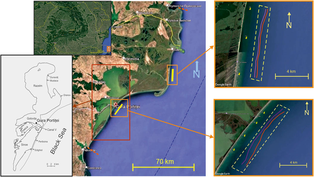
Figure 1. The Danube Delta coast; the location of the Iron Gates hydropower system is shown in the upper panel; the dotted orange lines mark the extension of the Danube Delta coast and the dotted green line marks the position of the Sulina jetties; detail on the Razelm – Sinoe Lagoon System is shown in the left panel; the proposed locations for the artificial reefs, as well as the output points used in the analysis, are shown on the right panels, marked by yellow dotted rectangles; the purple line is the 5 m isobath and the red line is the 7 m isobath.
The Danube River discharges into the Black Sea through three distributaries: Kiliya (or Chilia in Romanian), the northernmost, which forms a secondary delta in Ukraine, Sulina, the major waterway, and Sf. Gheorghe, the southernmost.
The Danube Delta’s coastal morphology is significantly influenced by the sediment transport dynamics of the three distributaries, as each one contributes differently to sediment deposition and coastal shaping due to variations in water discharge, sediment load, and interactions with marine processes.
The high sediment deposition from the Kiliya branch results in progradation, contributing to the expansion of the delta front into the Black Sea (Panin, 2005; Stănică et al., 2011). The modifications along the Sulina distributary have led to a reduction in sediment deposition at the mouth, contributing to coastal erosion in adjacent areas due to the diminished sediment supply (Dan et al., 2009; Stănică and Panin, 2009; Stănică et al., 2011). The sediment deposition from the Sf. Gheorghe distributary has led to the development of barrier islands (Stănică and Panin, 2009) and spits (Dan et al., 2009), influencing the coastal configuration, and providing protection against wave action.
The Danube Delta coast has been affected by human interventions such as construction of various structures along the Danube and the Romanian Black Sea coast, as discussed in the works of Stănică et al., 2007, 2011; Stănică and Panin, 2009; Dan et al., 2007, 2009. The most important structures are the dams of the hydropower plants Iron Gates I and II, built in 1970 and, respectively, in 1983, at the entrance of the Danube in Romania, approximately 900 km upstream from the Black Sea (Figure 1).
Besides serving as part of an important source of energy, these dams have acted as sediment traps, reducing almost by half the sediment fluxes reaching the Danube Delta (Panin, 1996; 1998; Giosan et al., 1999; Ungureanu and Stãnicã, 2001; Stănică et al., 2007; Stănică and Panin, 2009).
Other structures that have a strong impact on the distribution of sediments along the Danube Delta coast are the Sulina jetties (Figure 1), built in the mid-19th century, for navigation purposes. These structures were progressively extended, to reduce the accumulation of sediments, until they reached 8 km long (Dan et al., 2009; Stănică and Panin, 2009). The jetties block the alongshore sediment transport and cause downdrift erosion south of Sulina (Dan et al., 2009), as well as a dramatic decrease of sediment supply to the southern shores of the Danube Delta (Constantinescu et al., 2023).
Moreover, a minimum water depth of 8 m must be maintained at the Sulina mouth for navigation purposes, by regular dredging of the mouth bar and dumping the sand in offshore locations, which is an additional cause for beach erosion in the Sulina–Sf. Gheorghe area (Dan et al., 2009).
Summarizing, construction of the dams on the Danube led to reduced sediment fluxes to the Danube Delta, installation of the Sulina jetties caused downdrift erosion on the coast between Sulina and Sf. Gheorghe, while dredging has disrupted the natural sediment dynamics.
The hydro-sedimentary conditions of the Danube Delta coast are shaped by the interaction of riverine, marine, and climatic processes, creating a dynamic and evolving coastal system. The Danube River delivers a large sediment load (∼30–35 million tons/year) to the delta, with deposition concentrated in the Sulina and Kiliya branches. The sediment transport is affected by waves, currents, and longshore drift, redistributing materials along the coast (Stănică et al., 2011; Constantinescu et al., 2023). The northern sector (north of the Sulina mouth) is progradational (Panin, 2005), the Sulina sector has stabilized due to the presence of jetties, while the southern sector (south of the Sulina mouth) experiences erosion.
The coastal morphology is influenced by northeast and east winds, generating longshore currents (Stănică and Panin, 2009; Stănică et al., 2011; Dan et al., 2009; Dinu et al., 2013). The main southward longshore current is due to the Danube’s buoyant flow and transports sediment from the Danube’s mouths toward the southern delta and further along the Romanian and Bulgarian coasts (Stănică and Panin, 2009).
Stronger winds from the southern sector may change the current direction. The presence of the Sulina jetties determines an eddy-like anticyclone current (Dan et al., 2009; Stănică and Panin, 2009). Along the Sf. Gheorghe beach, which is more exposed, current velocities may exceed 30 cm/s for strong wind, with speed over 10 m/s (Dinu et al., 2013).
Wave heights range from 0.5 to 1.5 m, in moderate wind conditions, and from 2 to 4 m, in extreme weather conditions. According to Dan et al., 2009, waves from the northern sectors (N to ENE) have the largest average wave heights and dominate the shoreline behaviour. Higher energy events lead to increased coastal erosion. Storm surges and seasonal variations influence coastal sediment distribution and delta front shaping.
Due to its special status of nature reserve, only traditional activities are allowed in the Danube Delta, such as fishing and reed harvesting, as well as ecotourism. As most of the Danube Delta coast is affected by erosion, the National Integrated Coastal Zone Management (ICZM) legislation (Emergency Ordinance 202/2002 replaced by the National Law 280/2003) foresees a setback line, in which no permanent buildings are allowed, varying between 50 and 150 m from the shoreline. Impacts of extreme events and sea level rise will accelerate the process of erosion.
ICZM frameworks prioritize the preservation of coastal ecosystems. Artificial reefs are recognized within these frameworks as tools to enhance marine habitats, promote biodiversity, and restore degraded areas. In the Danube Delta, artificial reefs can provide substrates for marine organisms, contributing to habitat complexity and ecological resilience. ICZM policies advocate for sustainable erosion mitigation measures and encourages the incorporation of artificial reefs into broader coastal management strategies. For instance, Romania’s “Coastal Erosion Reduction Phase II (2014–2020)” project aligns with ICZM principles by implementing measures such as artificial reefs to rehabilitate and protect shorelines, adjacent lands, and marine ecosystems.
Our study focuses on two areas along the Danube Delta coast, described in the following sub-sections. Panin, 2005 discusses the threat of sea level rise for the Danube Delta coast, leading to a decrease of the water discharge and current velocities and, thus, of the sediment transport capacity. Panin, 2005 also mentions the selected areas among the most vulnerable sectors to climate change.
2.1.1 The zone north of the Sf. Gheorghe mouth
Most of the coastal zone between the Sulina and Sf. Gheorghe mouths is directly affected by erosion, caused by the presence of the Sulina jetties, as discussed by Dan et al., 2009; Stănică and Panin, 2009; Stănică et al., 2011.
The most extended part of the coast between Sulina and Sf. Gheorghe, of about 20 km, is retreating at high rates, between 5 and 25 m/year, as discussed by Ungureanu and Stănică, 2001; Stănică and Panin, 2009; Stănică et al., 2011. Two restricted areas of the Sulina–Sf. Gheorghe coast show different trend: the northern one, up to 6–7 km south of the Sulina jetties, which is prograding, due to the sheltering from northern waves (Dan et al., 2009), and the southern one, 6 km north of the Sf. Gheorghe mouth, which is stable (Stănică and Panin, 2009; Stănică et al., 2011).
Vespremeanu-Stroe et al., 2017 discuss that the coast between Sulina and Sf. Gheorghe experienced maximum erosion rates, reaching 20–25 m/year between 1961 and 1979, which diminished considerably to 10 m/year after 1980. These authors state that coastal areas affected by accelerated erosion did not extend their length during the 1961–1979 more energetic interval, but expanded alongshore with more than 13 km during the less active 1979–2006 interval. Moreover, they discuss that there is a marked difference between the 1961–1979 time interval, characterised by dominantly negative North Atlantic Oscillation (NAO) phase, which determined active storminess, inducing high shoreline mobility, and the 1979–2006 period, which showed less dynamic coastlines, as a result of the lower storminess imposed by the dominance of positive NAO phase.
2.1.2 The Gura Portiței zone
This zone is part of the Razelm-Sinoe Lagoon System (Figure 1), originally a marine bay, that became isolated from the sea, following the accumulation and redistribution of sand bars. Human interventions aimed at connecting the Razelm (also known as Razim) Lagoon to the Sf. Gheorghe branch of the Danube, via two channels, that ended up being dredged at the beginning of the XXth century. During the 1950s, management plans involved decrease of the salinity in the lagoon system, to increase the freshwater fish culture productivity. Thus, between 1960 and 1990, the lagoon system was controlled by hydrotechnic locks, in order to be used for irrigation and also for fish breeding. In 1973, the Portiţa inlet of the Razelm Lagoon was completely closed by a system of breakwaters and groins. The Razelm Lagoon and the Sinoe Lagoon were connected via two artificial canals, but only one of them, Canal V, is open nowadays (Figure 1). The water circulation between the Sinoe Lagoon and the Black Sea is controlled by the Periboina and Edighiol locks.
All these human interventions have triggered major changes of the hydrologic regime and of the sediment dynamics. The barrier beach separating the lagoon system from the sea is almost entirely affected by coastal erosion. In the sector situated south of the former Portița inlet, due to the hard coastal defence structure, the erosion increased in intensity (Spătaru, 1990; Vespremeanu-Stroe et al., 2007; Dinu et al., 2015).
As this area is important for fish breeding and also for tourism, there is a high need to protect it from the effects of climate change. Artificial reefs could enhance fish stocks and provide economic opportunities for the local community.
2.1.3 Adaptation strategy for the Danube Delta coast
The BaU (Business as Usual) strategy for the Danube Delta coast involves maintenance for the existing hydrotechnical works at Periboina and Edighiol, as well as the harbour jetties in Sulina and Cape Midia, north of Constanța city (Figure 1). Structural measures, set by the Master Plan for the protection against erosion and rehabilitation of the Romanian coastal zone (HALCROW UK et al., 2012), involve sediment bypass of the Sulina jetties and artificial nourishment. Both measures have started to be implemented after the approval of the third Stage of the Coastal Protection Plan (after 2023) and should become operational by 2026 at the latest. The adaptation strategy extends the BaU strategy with additional green measures, such as channelization (Giosan et al., 2013; 2014), planting reedbeds (Möller et al., 2022) and construction of artificial reefs (Sheehy, 1981; 1982; Shomomura, 1982; Bohnsack and Sutherland, 1985; Mathews, 1985; Baine, 2001; Lokesha et al., 2013)).
Any type of coastal protection against coastal erosion along the Danube Delta coast must take into account the specific status of this area. Since the Danube Delta territory is a Nature Sanctuary (Biosphere Reserve, part of the Man and the Biosphere Programme of the UNESCO), with most of the coast left in the wild, with very few permanent buildings, classical hard coastal protection measures would never be accepted neither by the coastal managers, nor by the delta authority or wider public. In the meanwhile, the coastal erosion rates are much higher than the natural processes due to the significant human interventions in the sediment budget, either upstream the river or at its mouths. With a forecasted increase of the erosional phenomena due to climate change signals (HALCROW UK et al., 2012), if no measure of coastal protection is taken, the coastal ecosystems along the entire delta are under risk to be affected.
Hence the need to combine methods of coastal protection that would be effective but, in the same time, respect some specific requests, such as the need to deal with the negative visual impact of classic wave breakers or other hard engineering structures.
Artificial reefs are man-made structures placed in marine environments to protect coastlines and enhance marine life or support fisheries. These structures mimic natural reefs by providing hard surfaces for marine organisms to attach to, which in turn attract larger species. Materials used for artificial reefs include concrete, steel, repurposed ships, and purpose-built reef modules.
Artificial reefs act as submerged breakwaters, reducing wave height and energy. They also provide shelter and breeding conditions for marine species, thus supporting commercial and recreational fishing.
The main benefits of artificial reefs are enhancement of biodiversity, by attracting various marine species, improvement of fisheries, coastal protection. However, there are also environmental challenges related to their presence. Poorly placed artificial reefs can disrupt natural sediment flows or introduce pollutants. They involve high costs, as construction and maintenance require significant investments. Materials can break down and create marine debris. They may attract too many fish and become vulnerable to overfishing.
Therefore, such a nature-based solution requires proper planning and material selection, as well as monitoring, to ensure that it would provide long-term benefits without unintended consequences.
In this study we evaluate the feasibility of artificial reefs as measure to counteract the present coastal erosion. The analysis considers the present conditions and a set of climate change scenarios. A sensitivity test of the functioning of artificial reefs is performed for the two proposed locations with intense erosion, along the Danube Delta coast: north of Sf. Gheorghe mouth and at Gura Portiței (Figure 1), on the barrier beach separating the Razelm-Sinoe Lagoon System from the Black Sea. Such artificial reefs could be made of concrete.
2.2 Methodology
Figure 2 shows the flow chart with the methodology followed in this study to assess the effectiveness of artificial reefs to protect the two locations on the Danube Delta coast. The analysis has been done by means of the numerical model SWAN (Simulating WAves Nearshore) (Booij et al., 1999).
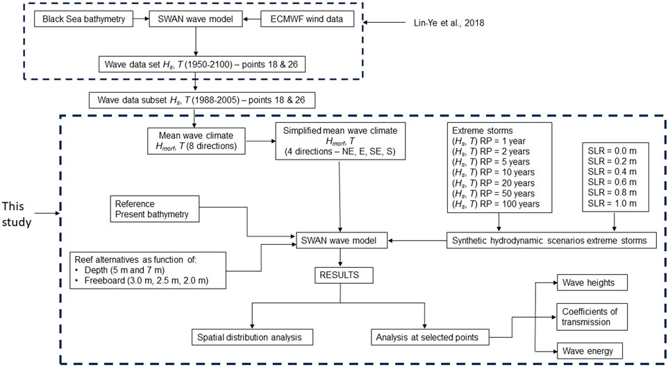
Figure 2. The workflow illustrating the methodology used.
Simulations have been run for a mean wave climate and for extreme storms. A hindcast data set, available from a previous work by Lin-Ye et al., 2018, has been used for the mean wave climate. We have also used extreme storms, available from a previous work performed by Johnson, 2011. Numerical simulations consider mean wave conditions and extreme storm events.
For all the analysed wave conditions, the first simulations have been run for the most updated existing bathymetry. Then, the bathymetry has been changed at the selected locations, in order to represent the freeboard of artificial reefs. The simulations in the same wave conditions have been repeated, with modified bathymetry. In this manner, we have analysed the effect of several artificial reefs layouts. Details are given in the following sections.
2.2.1 Mean wave climate
The wave data used to derive the mean wave climate is available from a previous study, performed by Lin-Ye et al., 2018, that characterized the extreme wave climate for the northwestern Black Sea with a hybrid strategy under two climate change scenarios, Representative Concentration Pathways (RCPs) 4.5 and 8.5 (Church et al., 2013; Stocker et al., 2013). Lin-Ye et al., 2018 used as input the RCP4.5 and RCP8.5 wind fields obtained by the ALADIN model (Colin et al., 2010; Farda et al., 2010; Herrmann et al., 2011) and downloaded from the Mediterranean Coordinated Regional Downscaling Experiment (Med-CORDEX) initiative (Ruti et al., 2016). The winds fields were used as inputs for the SWAN spectral wave model, run in a non-stationary mode, for the 1950–2,100 period (Figure 2). The wind fields for the 1950–2005 period were common for both scenarios, but they differed for the 2005–2,100 period. The computational domain spanned the whole Black Sea with a regular grid of 9 km × 9 km. The wave outputs were saved hourly in 34 computational nodes of the northwestern Black Sea, shown in Supplementary Appendix Figure SA1.
Lin-Ye et al., 2018 used the SWAN outputs to produce wave-climate projections for the northwestern part of the Black Sea. For both emission scenarios, the validation data set was the ERA-Interim reanalysis data set (Dee et al., 2011), provided by the European Centre for Medium Weather Forecast (ECMWF), covering 38 years, from 1979 to 2016.
The data set used in our study is from the points 18 and 26, available from Lin-Ye et al., 2018 (Supplementary Appendix Figure SA1). Point 18 is in front of the proposed location north of the Sf. Gheorghe mouth, and has the coordinates 30.045 °E, 44.896 °N. Point 26 is in front of the proposed location at Gura Portiței, and has the coordinates 29.512 °E, 44.480 °N.
The original wave data set covers 150 years. We decided it would be reasonable to use a subset of 18 years for this work, from 1988 to 2005. This time interval can be considered as featuring the present climate. For both points 18 and 26, the data set provides hourly values of significant wave height, associated wave period and wave direction.
For our study, first we have taken into account the wave directions that would impact the Danube Delta coast–NNE, NE, ENE, E, ESE, SE, SSE, and S.
Several wave height intervals, in 0.5 m bins, and wave period intervals, in 2 s bins, have been established for each of these directions. Then wave height values have been counted for each of these intervals. Finally, the frequency of occurrence has been computed for each case, by dividing the number of above-mentioned values by the total number of observations.
Hmorf is defined as the wave height that synthesizes the wave information (Equation 1), for every analysed direction:
where i is the number of a registered wave height between certain limits, Hi is the wave height and fi is its frequency of occurrence.
The Hi values have been considered in the middle of every wave height incremental interval. So, for the interval 0–0.5 m, the corresponding Hi value is 0.25 m; for the interval 0.5–1 m, the corresponding Hi value is 0.75 m.
The frequencies of occurrence for all the wave directions, in the points 18 and 26 from Lin-Ye et al., 2018, are reported in Supplementary Appendix Table SA1-A6.
The results of the Hmorf calculations for the points 18 and 26 available from Lin-Ye et al., 2018, are presented in Supplementary Appendix Table SA7.
As the Hmorf results for various directions are very close, we have decided to simplify the wave climate used in our simulations and focus on the main wave directions that may impact the Danube Delta coast–NE, E, SE, and S. Moreover, since we are treating mean wave conditions in this section, we have chosen only the ones for the average wave periods of 5, 7, and 9 s.
Finally, for the mean wave climate analysis performed in our study, we have chosen the highest Hmorf value corresponding to the average wave periods of 5, 7, and 9 s. These mean wave conditions are reported in Table 1.
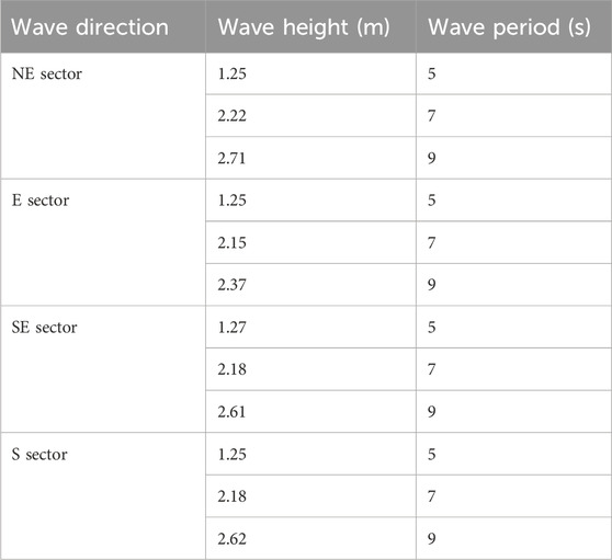
Table 1. Mean Wave Climate conditions.
2.2.2 Extreme storms from wave climate analysis
The hydrodynamic response of the proposed artificial reefs to high energetic events has been analysed taking into account the wave climate study carried out by Johnson, 2011, as part of the Master Plan for the protection against erosion and rehabilitation of the Romanian coastal zone (HALCROW UK et al., 2012). The analysis considers the storms that may impact the Danube Delta coast.
The data used in the wave climate study performed by Johnson, 2011 originated from the European Center for Medium Range Forecasting (ECMWF) WAM model (The WAMDI Group, 1988) archive and are validated and calibrated against a global buoy and satellite altimeter database. The data provided are six-hourly wind and wave parameters covering the 18.5 years period from 1 July 1992 to 31 December 2010. Johnson, 2011 carried out an Extreme Value analysis, using the MIKE EVA software by DHI (Danish Hydraulic Institute), for one offshore point, with the coordinates 44.5 °N, 30.0 °E, that was considered characteristic for the Romanian coast.
Finally, Johnson, 2011 provided extreme wave heights and associated wave periods that characterize the extreme storms for the Romanian coast. For our analysis, we selected the waves from the main directions that may impact the Danube Delta coast (from NE, E, SE, and S) with the following return periods (RPs): 1, 2, 5, 10, 20, 50, and 100 years. The waves, characterized by significant wave heights and associated wave periods, are shown on Table 2.
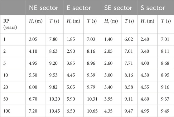
Table 2. Extreme storms considered, characterized by significant wave height Hs and associated return period T available from Johnson, 2011.
Johnson, 2011 carried out an Extreme Value analysis on a water level data set, available from a previous project (JICA, 2008) and provided the sea level rise associated to extreme storms, from the same main directions that may impact the Danube Delta coast. That 11 years water level data set covered the water level from January 1993 to December 2004. As mentioned above, the wind and wave data set used for the wave climate analysis (Johnson, 2011) covered the period from 1 July 1992 to 31 December 2010.
Because of this difference in number of years of the data sets, we have decided to cover a range of 1 m at different increments. Thus, more simulations have been run, progressively increasing the sea level from 0 to 1 m, by 0.2 m increments. Moreover, this value of 1 m can be considered an extreme for the Romanian Black Sea coast, according to the wave climate analysis performed by Johnson, 2011.
2.3 The wave model
The SWAN (Simulating WAves Nearshore) model is a third generation, phase-averaged, open-source numerical model that computes waves in coastal zones. The model is based the Eulerian formulation of the discrete spectral balance of action density, that accounts for refractive propagation over arbitrary bathymetry and current fields (Booij et al., 1999). The spectral energy balance models reproduce the specific wave transformation processes occurring when waves approach the coastline - refraction, diffraction, shoaling, generation, dissipation and wave -wave interactions (Holthuijsen et al., 2003; Holthuijsen, 2007).
The SWAN model solves the action balance equation with the associated source and sink terms. without any a priori restriction on the wave spectrum. For this case study, the nearshore wave propagation terms have been activated, while the wave generation, which is more suited to deep waters, has been deactivated.
The wave energy dissipation has been modelled through depth-induced bottom friction (Madsen et al., 1988), with the equivalent roughness length scale of the bottom 0.05 m, and depth-induced wave breaking (Battjes and Janssen, 1978), with a breaker index that scales with both the bottom slope and the dimensionless depth. Triad wave-wave interactions have been activated as well, with the method of Eldeberky and Battjes, 1996 and a proportionality coefficient of 0.65.
Grid spacing may affect significantly the SWAN model accuracy. A coarse grid may reduce computation time, but it can lead to loss of small-scale features, especially in nearshore areas, with rapid depth changes. It may not provide a good representation of the bathymetry. A fine grid may increase computational cost, but it may also capture bathymetry variations and provide a more accurate representation of the wave transformation processes.
The grid was created using SURFER ©, with an initial resolution of 0.0025 decimal degrees. The grid extension was adjusted to have a good representation of the bathymetry, especially at the boundaries of the modelled domain. The resolution has been progressively increased, first to 0.0015, then to 0.001 decimal degrees spacing on x and y directions, until the bathymetry contours were smoothed.
In order to run the SWAN model on our modelled domain, we have used the waves from the main directions that may impact the Danube Delta coast. These are NE, E, SE, and S.
2.4 Simulations setup
The modelled domain extends from the Danube Delta coast to a maximum depth of 82 m.
Reference simulations have been setup and run with the real bathymetry and the wave forcings mentioned in Tables 1, 2, for the analysed directions that may have a potential impact on the Danube Delta coast. The real bathymetry corresponds to Layout 0.
Artificial reefs are represented in the model by adjusting the bathymetry of the grid elements, at the proposed locations. The adjusted bathymetry values correspond to the freeboard of the proposed structures.
The 5–7 m depth range serves as an important habitat for benthic organisms and fish species. Therefore, two locations, at 5 m and 7 m deep, have been tested for placing artificial reefs both for the zone north of Sf. Gheorghe mouth and the Gura Portiței zone.
The model bathymetry was changed in the 5 m deep cells at both proposed locations. Later, the same thing was done for the 7 m deep cells. The artificial reefs proposed in our study are caisson breakwaters, developed along the 5 m and 7 m deep isobaths (Figure 1). No other shape or orientation have been analysed at this stage of the study. For the proposed artificial reefs, three freeboard values were tested: 3 m, 2.5 m, and 2 m. Table 3 summarizes the different simulated layouts, denoted as AR1 to AR6, each of them resulting in a grid with adjusted bathymetry, used for simulation.
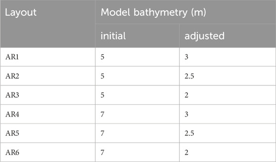
Table 3. Layouts for the proposed artificial reefs.
The SWAN model has been run for various wave forcings, characterized by significant wave height, associated wave period and wave direction, in mean wave conditions and for extreme storms with different return periods. For each wave forcing condition considered, the values of significant wave height Hs and associated wave period T correspond to the peak of the storm.
We have proceeded in the same manner for the mean wave climate and for the extreme storms. The setup of the SWAN model was repeated for specific wave conditions, characterized by the significant wave height, associated wave period and wave direction.
For the extreme storms, the effect of sea level rise has been analysed as well. In order to achieve this, we repeated the same extreme wave conditions, shown on Table 2, in several simulations, also considering sea level of 0, 0.2, 0.4, 0.6, 0.8, and 1 m.
A total number of 84 simulations have been setup and run for the mean wave climate, for the three return periods and four directions considered (Table 1) and for each of the seven bathymetries used (the original bathymetry and six adjusted bathymetries).
A total number of 1,176 simulations have been setup and run in extreme storm conditions (Table 2), 168 simulations (4 directions considered, seven values of the return period, six values for sea level rise) for each of the seven bathymetries used (the original bathymetry and six adjusted bathymetries).
A MATLAB © script has been used to plot the distribution of wave heights on the represented domain.
2.5 Coefficient of transmission and wave energy attenuation
The feasibility of artificial reefs for coastal protection is typically evaluated based on the percentage of surface wave height reduction over structures parallel to the shore (e.g., Shirlal and Rao, 2007).
Analysis of the results in our study area is based on two characteristic indicators for the proposed structures.
The coefficient of transmission (Equation 2) of an artificial reef (Pilarczyk, 1992; Fauzi et al., 2017; Jafarzadeh et al., 2021) is the ratio between the transmitted wave height, between the structure and the shoreline, and the incident wave height, in the offshore zone:
where Ht is the transmitted wave height (m) and Hi is the incident wave height (m).
The Wave Energy (WE) (Equations 3, 4) can be expressed as following, according to the formula for random irregular waves (Holthuijsen, 2007):
for the incident waves and
for the transmitted waves.
In the formulas above, WE is the mean wave energy density per unit horizontal area, ρ is the sea water density [M⋅ L-3], g is the gravitational acceleration, equal to 9.81 m/s2, and Hi, Ht are the incident and transmitted significant wave heights [M].
The water density has been considered 1,015 kg/m3, based on the available information for the Black Sea (Yankovsky et al., 2004).
The Wave Energy density ratio (WEr) in the context of artificial reefs refers to the proportion of wave energy dissipated or reduced by the reef structure compared to the incoming wave energy. It is a critical parameter in assessing the effectiveness of artificial reefs in coastal protection, erosion control, and habitat enhancement. A similar approach, denoted as “relative wave-energy reduction” has been used in the work of Ghiasian et al., 2021.
The WE density ratio (WEr) is calculated as (Equation 5):
3 Results
The results of all the simulations performed were extracted in few output points, that are shown on Figure 1. The points 10 to 12 are placed between the shoreline and the artificial reef located at the zone north of the Sf. Gheorghe mouth. The points 23 to 26 are placed between the shoreline and the artificial reef located at the Gura Portiței zone.
The results of all the simulations, in the selected output points, are presented in the Supplementary Material.
3.1 Simulations in mean wave conditions
The results of the simulations performed in mean wave conditions are presented in Supplementary Appendix SB, in 7 Excel files, for each one of the output points. The output points are indicated in the names of the files.
The lowest value of the coefficient of transmission is 0.17 and occurs for the point 12, with the AR3 layout, for waves from the eastern sector, with the RP of 9 s. The corresponding WEr also reaches the minimum value of 3.02%.
Nevertheless, the behaviour of artificial reefs in extreme wave conditions is of much higher interest and it is treated in the following sections.
3.2 Distribution of wave heights in extreme storm conditions
The results of the simulations performed in extreme wave conditions are presented in Supplementary Appendix SC, in 7 Excel files, as well as in 7 Word files, containing tables with the calculated coefficients of transmission, for each one of the output points. The output points are indicated in the names of the files.
Figures 3, 4 show examples of wave height distributions, in the zones north of Sf. Gheorghe and Gura Portiței, for the reference (REF) and layout 6 (AR6) simulations, for the extreme storm from the southern sector, with the return period (RP) of 20 years and sea level rise (SLR) of 0.4 m.
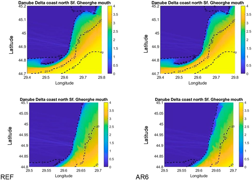
Figure 3. Distribution of wave heights for the reference (REF) and layout 6 (AR6) simulations in the zone north of the Sf. Gheorghe mouth, for the extreme storm from the southern sector, with RP 20 years and SLR 0.4 m; the lower snapshots show details in the area between the shoreline and the location of the proposed artificial reef.
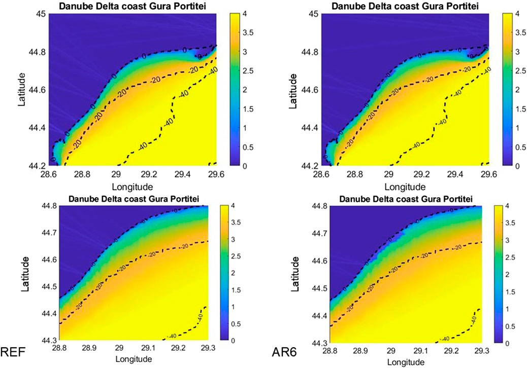
Figure 4. Distribution of wave heights for the reference (REF) and layout 6 (AR6) simulations in the Gura Portiței zone, for the extreme storm from the southern sector, with RP 20 years and SLR 0.4 m; the lower snapshots show details in the area between the shoreline and the location of the proposed artificial reef.
Details are needed in the lower snapshots, to see the differences in the distribution of wave heights, between the proposed locations of the artificial reefs and the shoreline.
Table 4 shows the wave heights in extreme storm conditions, calculated in all the output points, for the REF and AR6 simulations corresponding to the distributions shown in Figures 3, 4.
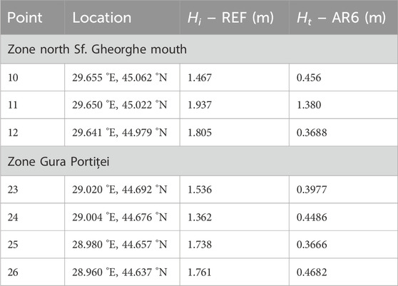
Table 4. Wave heights in the output points for the REF and AR6 simulations, for the extreme storm from the southern sector, with the return period of 20 years and sea level rise of 0.4 m; the points are shown on Figure 1.
3.3 Coefficients of transmission for extreme storm conditions
The lowest value of the calculated coefficients of transmission is 0.08 and occurs for the point 12, with the AR3 layout, for storms from the eastern sector, with the RPs of 10 years and 100 years, both with sea level rise (SLR) 0.
The highest value of the calculated coefficients of transmission is 0.99 and occurs for the point 26, with the AR1 layout, for storms from the northeastern sector, with the RP of 1 year and SLR of 1 m.
For some specific conditions, calculated values slightly over 1 may occur, e.g., in the point 26, with the AR3 layout, for storms from the northeastern sector, with the RP of 1 year and SLR from 0.6 to 1 m. Most probably, this is due to numerical artifacts.
Table 5 shows the lowest calculated coefficients of transmission for every one of the output points. The layout and the storm for which the lowest values occur are also reported. For a certain layout, the same lowest Kt value can be reached for different wave conditions. This happens for points 10, 12, 23, 25, and 26 (Table 5).
Table 5. Lowest calculated coefficients of transmission in the output points.
The lowest coefficient of transmission is 0.08 and it has been determined in the point 12, with the AR3 layout, for waves from the eastern sector with the RPs of 10 years and 100 years and SLR 0.
3.4 Wave energy attenuation in extreme storm conditions
The lowest value of the calculated WEr is 0.61% and occurs for the point 12, with the AR3 layout, for the extreme storm from the eastern sector, with the RP of 10 years and SLR 0. The AR3 layout with this storm also gives the lowest value of the coefficient of transmission.
The highest value of the calculated WEr is 99.15% and occurs for the point 26, with the AR3 layout, for storms from the northeastern sector, with the RP of 1 year and SLR of 0.6 m. For these specific conditions, the calculated coefficient of transmission is 1, as shown in the file for point 26 from the Supplementary Material.
For some specific conditions, calculated values slightly over 100% may occur, e.g., in the point 26, with the AR3 layout, for storms from the northeastern sector, with the RP of 1 year and SLR of 0.8 m and 1 m. These are the same wave conditions, in the same point, for which the calculated values of the coefficient of transmission are slightly over one and can be considered as numerical artifacts.
Table 6 shows the lowest calculated WEr for every one of the output points. The layout and the storm for which the lowest values occur are also reported.
Table 6. Lowest calculated WEr in the output points.
The lowest value of the WEr is 0.61 and occurs in the Point 12, with the AR3 layout and for waves from the eastern sector, with the RP of 10 years and SLR 0. The lowest value of the coefficient of transmission has been reached for the same layout and with the same wave conditions.
The WEr values for all the simulations, in all the output points, are reported at the end of each result file from the Supplementary Material. The lowest WEr values are associated with the lowest Kt values.
As previously mentioned, the lowest Kt values can be reached for several wave conditions. In such cases, the WEr value could be an indicator to estimate in which wave conditions an artificial reef would provide the highest efficiency.
3.5 Analysing the results of the simulations in extreme storm conditions
The main purpose of running so many simulations has been to test the efficiency of the proposed artificial reefs in extreme storm conditions.
In this section, we focus on the results extracted in two points (Figure 1): Point 11 – located between the shoreline and the artificial reef at the zone north of the Sf. Gheorghe mouth and Point 25 – located between the shoreline and the artificial reef at the Gura Portiței zone.
3.5.1 Coefficients of transmission
Mean water level (MWL) in Figures 5–8 stands for the sea level rise.
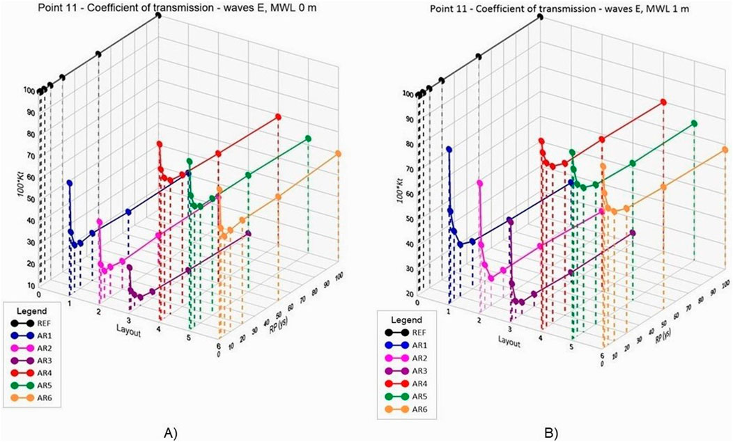
Figure 5. Coefficients of transmission in Point 11 (zone north of the Sf. Gheorghe mouth) for the storms from the eastern sector–(A) no sea level rise; (B) sea level rise (MWL) of 1 m.
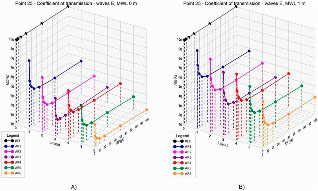
Figure 6. Coefficients of transmission in Point 25 (Gura Portiței zone) for the storms from the eastern sector–(A) no sea level rise; (B) sea level rise (MWL) of 1 m.
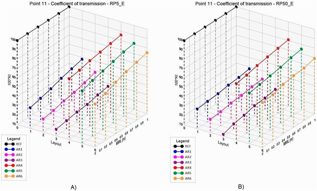
Figure 7. Coefficients of transmission in Point 11 (zone north of the Sf. Gheorghe mouth) for the storms from the eastern sector with return period of (A) 5 years; (B) 50 years.
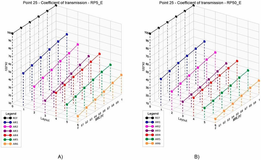
Figure 8. Coefficients of transmission in Point 25 (Gura Portiței zone) for the storms from the eastern sector with return period of (A) 5 years; (B) 50 years.
Figure 5A; Figure 6A show the coefficients of transmission (multiplied by 100) in the Points 11 and 25, for the storms from the eastern sector, with different RPs, in the absence of sea level rise.
Figure 5B; Figure 6B show the coefficients of transmission (multiplied by 100) in the Points 11 and 25, for the storms from the eastern sector, with different RPs, with SLR of 1 m.
Figures 5, 6 show that, starting from the RP of 10 years, the coefficients of transmission appear to have an asymptotic behaviour. That means that the efficiency of the proposed structures appears to reach its upper limit. The coefficients of transmission are of the same order for extreme storms from the eastern sector with RPs starting with 10 years.
Figure 7A; Figure 8A show the coefficients of transmission (multiplied by 100) in the Points 11 and 25, for the storms from the eastern sector with the RPs of 5 years, for different values of the mean water level (MWL).
Figure 7B; Figure 8B show the coefficients of transmission (multiplied by 100) in the Points 11 and 25, for the storms from the eastern sector with the RPs of 50 years, for different values of the mean water level (MWL).
Figures 7, 8 show that, starting from the sea level rise of 0.6 m (MWL 0.6 m), the coefficients of transmission appear to have an asymptotic behaviour. The coefficients of transmission are of the same order for extreme storms from the eastern sector with sea level rise starting with 0.6 m.
Thus, we can consider that, in the case of storms from the eastern sector, the proposed solution for reduction of wave heights along the Danube Delta coast reaches its highest efficiency for RPs starting with 10 years and sea level rise starting with 0.6 m.
Figures 5–8 show that, for both proposed locations, the coefficients of transmission decrease as the height of the structures increase, being in agreement with Shirlal and Rao, 2007; Jafarzadeh et al., 2021.
The calculated coefficients of transmission in the output points 10 and 12 show similar trends to the ones in point 11. The same thing can be noticed for the calculated coefficients of transmission in the output points 23, 24 and 26, that show similar trends to the ones in point 25. These observations are valid for all the analysed wave directions. This can be checked in Supplementary Appendix D, which contains 10 figures, two for each of the above mentioned output points, that are similar to Figures 5–8.
3.5.2 Transmitted wave heights
Obviously, all the output points show the lowest transmitted wave heights for AR3 and AR6, thus for layouts with 2 m freeboard.
The transmitted wave heights in all the output points, for the AR3 and AR6 layouts, are summarized in Table 7, that also shows the respective storm conditions. The difference in the transmitted wave heights is reported as Ht (AR3) – Ht (AR6).
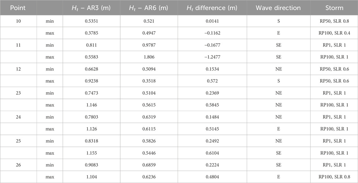
Table 7. Minimum and maximum difference in the transmitted wave heights with the AR3 and AR6 layouts and corresponding storm characteristics.
For the output points 10 to 12, located between the shoreline and the artificial reef at the zone north of the Sf. Gheorghe mouth, the lowest difference in transmitted wave heights between AR3 and AR6 is 1.4 cm, occurring in Point 10, for storms from the S sector, with the RP of 50 years and sea level rise of 0.8 m. The highest difference is 1.25 m, in favour of AR3, occurring in Point 11, for storms from the SE sector, with the RP of 100 years and sea level rise of 1 m.
In what concerns the output points 23 to 26, located between the shoreline and the artificial reef at the Gura Portiței zone, the lowest transmitted wave heights are for AR6, located at 7 m deep. The lowest difference between AR3 and AR6 is 15 cm, occurring in Point 2 4, for waves coming from the NE sector, with the RP of 1 year and sea level rise of 1 m. The highest difference is 61 cm, occurring in Point 25, for waves coming from the SE sector, with the RP of 100 years and sea level rise of 1 m. These differences are in favour of AR6, but such values would not justify significantly higher costs for a reef at 7 m deep and with increased height.
According to our results, the best option for coastal protection in both zones is an artificial reef placed at 5 m deep and with a 2 m freeboard, thus the layout denoted as AR3.
The AR3 layout involves a 3 m high structure, while the AR6 layout involves a 5 m high structure. Obviously, the cost of the AR3 structure would be lower, while the efficiency and coastal protection would be comparable to the one of the AR6 structure, as indicated by the transmitted wave heights.
The variations of the transmitted wave heights from the eastern sector over the return period and sea level rise, for the extreme storms considered from the eastern sector, for the different layouts, are shown in Supplementary Appendix Figure E1.1-E1.7 for the Point 11, and in Supplementary Appendix Figure E3.1-E1.7 for the Point 25. The graphs presented in these appendices emphasize an asymptotic behaviour with respect to the sea level rise, also denoted as MWL, for all the considered extreme storms.
The variations of the transmitted wave heights from the eastern sector over the reference case and the various artificial reefs layouts and sea level rise, for the extreme storms considered from the eastern sector, are shown in Supplementary Appendix Figure E2.1-E2.7 for the Point 11, and in Supplementary Appendix Figure E4.1-E4.7 for the Point 25. These graphs emphasize a significant decrease for AR3 and AR6, also in sea level rise conditions.
The observations concerning the coefficients of transmission and the transmitted wave heights are valid for the other analysed directions (NE, SE, S) and for the other output points (10, 12, 23, 24, 26) as well. This can be checked in the data files containing the results of all the simulations in the Supplementary Material.
Moreover, the inspection of the transmitted wave heights in the data files from the Supplementary Material reveals an asymptotic behaviour with respect to the return period, for all the proposed artificial reefs layouts.
4 Discussion
The artificial reefs offer several advantages in terms of cost, coastal protection and environmental impact. They are effective in reducing wave heights and energy and, thus, coastal erosion. They provide habitat for marine species and promote biodiversity. They can be built from recycled materials, such as concrete (Baine, 2001), thus helping in improving waste management. These are potential long-term benefits. But they require proper planning and construction, as well as monitoring, leading to significant investment.
In our work we have attempted to test the efficiency of artificial reefs as a nature-based solution to reduce erosion along the Danube Delta coast, using numerical modelling. But we treated the problem only from the hydrodynamic point of view, which is a first step.
The results of the simulations in Points 10 to 12 show lower coefficients of transmission for the layouts one to 3, suggesting that artificial reefs located at 5 m deep are more efficient for the zone north of the Sf. Gheorghe mouth. Strictly based on the results in Points 23 to 26, showing lower coefficients of transmission for the layouts four to 6, artificial reefs located at 7 m deep appear to be more efficient for the Gura Portiței zone. But this would not justify significantly higher costs for a reef with increased height.
The transmission coefficients of the proposed structures have the lowest values for the AR3 and AR6 layouts, with 2 m freeboards, indicating that these appear to be the most efficient in reducing wave height and energy.
The transmitted wave heights by the proposed structures in the output points have been compared as well, showing a maximum difference of 1.25 m in the area north of the Sf. Gheorghe mouth, in favour of the AR3 layout, in specific extreme wave conditions. The maximum difference in the Gura Portiței zone is 0.6 m, in favour of the AR6 layout, also for specific conditions. However, the graphs from the Supplementary Appendix Figure E4.1-E4.7) show that the transmitted wave heights in the Point 25 reach a maximum around 0.8 m, regardless of the return period, with the AR3 layout.
Moreover, the cost of the 3 m high AR3 structure would be lower than the one of the 5 m high AR6 structure, while the efficiency would be comparable, as shown by our results.
Our study suggests that the best option for coastal protection in both zones is an artificial reef placed at 5 m deep and with a 2 m freeboard.
The presence of an artificial reef may modify areas of erosion and deposition of sediments in adjacent locations (London Convention and Protocol/UNEP, 2009).
Even if our results show that artificial reefs could be efficient in reducing wave height and wave energy, morphodynamics also needs to be considered. For this purpose, more complex models such as XBeach (Roelvink et al., 2010) and Delft3D (Deltares, 2023) should be used and calibrated in a future step of the study, to solve suspended transport and to account for bed updating. Both models require data on bathymetry, water level, Danube discharge, wind speed and direction and wave height, period and direction, as well as sediment grain size distribution and sediment transport rates. Therefore, the use of such modelling approach would require dedicated field campaigns, covering the hydrodynamic and morphodynamic variables that are necessary to setup the boundary conditions and calibrate the models.
For both models, the grid resolution should be increased in the vicinity of the coast and coarser at higher depth. XBeach will be used for the simulation of short-term extreme events and it will be calibrated based on the storm-induced beach profile changes. Delft3D, coupled with SWAN, will be used for the simulation of long-term coastal evolution and it will be calibrated based on the bed and shoreline changes. In our case, Delft3D could be used on a less extended grid, with increased resolution in the areas where the proposed artificial reefs are placed, coupled with SWAN on the same grid used in our study.
Wave flume experiments are useful in order to analyse wave-structure interactions and wave breaking, as well as for calibrating flow regimes and sediment properties. Johnson et al., 2005 emphasize the ability of models to reproduce the observed waves and current patterns and stress the necessity of this step for improving understanding of the sediment transport and morphological evolution around low crested coastal defense structures, to achieve a good functionality.
Hydraulic experiments could prove useful before taking a decision on implementing any solution for coastal protection. This becomes more obvious if artificial reefs are chosen, since they would have impact on hydrodynamics, involve problems related to scouring (Sumer et al., 2001; Khan-Mozahedy et al., 2016) and significant costs.
Hydraulic experiments may give trends of the water dynamics around structures (Johnson et al., 2005; Ranasinghe et al., 2006; Srisuwan and Rattanamanee, 2015; Zheng et al., 2019; Shu et al., 2021; Tang et al., 2022; Wang J. et al., 2022; Pan et al., 2022; Kuang et al., 2024). But, as pointed out by Henriquez et al., 2008, it is essential to ensure that the laboratory model has the same flow and transport regimes as in the prototype and that sediment properties are suitable.
Overall, we appreciate that wave flume experiments could be very useful in understanding the effect of artificial reefs in the proposed locations along the Danube Delta coast, as they provide fundamental data on flow-sediment interaction. Calibration of the flow regime and of the sediment transport around structures are essential for accurate morphological predictions.
In what concerns experimental studies on artificial reefs in the Black Sea area, we can mention the work of Düzbastilar et al., 2006. These authors carried out hydraulic experiments in a unidirectional wave channel, to investigate the behaviour of several artificial reef units located in the southeastern part of the Black Sea, along the western coast of Turkey (Lök et al., 2002). They determined deployment areas, to ensure stability of artificial reefs in specific wave conditions for the Black Sea Turkish coast. The results of this study suggest a minimum depth of 20 m for the deployment of artificial reefs in the investigated area.
The depth for artificial reefs depends on various factors, such as local biodiversity, hydrodynamics and sedimentation. For the Black Sea coasts of Turkey, artificial reefs are deployed at depths around 20 m, where many species have been identified (Lök et al., 2002). Along the Danube Delta coast, many freshwater and marine species have been identified at depths between 5 and 15 m. These depths are important for a variety of marine species and, at the same time, they often serve as transitional zones for freshwater species.
The above listed case studies prove that artificial reefs need complex investigations even if they appear as efficient solutions for coastal protection. Both experimental and modelling studies involve significant effort. Building and maintenance of the structures involve significant costs and effort. Therefore, a detailed analysis is needed before taking the decision to adopt this coastal protection solution.
Artificial reefs influence wave energy and hydrodynamics, altering sediment transport. If they are not placed properly, they may disrupt the longshore drift, increasing erosion downstream. Their presence may alter currents, so that sediments are driven away from critical areas. The ability of an artificial reef to dissipate wave energy depends on its porosity, shape and orientation. These factors must be carefully considered and customized based on local wave and sediment transport conditions to optimize the effectiveness of the structures.
Moreover, artificial reefs must be designed for decades of function, so they must face climate change challenges, such as sea level rise and storms. Field monitoring is needed to assess real-time changes in sediment transport and morphodynamic modelling is needed to predict sediment behaviour. Hydraulic experiments and numerical simulations are also needed to test reef stability. Furthermore, ecological impact assessments are needed to study interactions between reefs and delta habitats. This involves stakeholder engagement, to balance the Danube Delta ecosystem, hydrodynamics, fisheries, and infrastructure needs.
A potential approach to an artificial reef project should combine phased implementation, pilot studies, and cost-benefit analysis, to minimize the cost and effort, while minimizing the risks. Using such a structured approach ensures efficient resource use, environmental sustainability, and long-term benefits for marine ecosystems and local communities.
The future step in the assessment of the effect of artificial reefs along the Danube Delta coast will be morphodynamic modelling, which should provide useful tools to identify tipping points (Kwadijk et al., 2010; Haasnoot et al., 2013) and analyse options for coastal protection, in order to develop adaptation strategies to climate change.
Morphodynamic modelling simulates sediment transport, seabed changes, as well as the shoreline evolution. It is essential for identifying tipping points, that are critical thresholds where small environmental changes can cause irreversible shifts in coastal stability. The XBeach model can be used to simulate storm-driven erosion and short-term changes, while the Delft3D model can be used to assess long-term evolution of the Danube Delta coast. Hydraulic modelling simulates waves and changes in local hydrodynamics around artificial reefs. By predicting future coastal changes due to climate change, such models guide nature-based solutions, as well as the development of adaptation strategies to climate change, for a resilient and sustainable Danube Delta coast.
The feasibility of artificial reefs along the Danube Delta coast depends on cost-benefit analysis, long-term sustainability, funding availability, and socio-economic impact. Evaluation of costs should consider construction and maintenance costs. Artificial reefs are feasible if proper funding and long-term management plans are available, if environmental monitoring and stakeholder involvement are ensured, and if the project is integrated with sustainable fisheries and tourism policies.
The long-term success of artificial reefs in the Danube Delta coast depends on ecological, economic, and social sustainability. The long-term effectiveness of such structures is related to coastal protection, by reduction of erosion and flood control, as well as to biodiversity restoration and to sustainable fisheries. Artificial reefs can be long-term effective if they serve both for coastal protection and enhancement of fisheries, and if they are properly managed and monitored.
The effectiveness of artificial reefs can be impacted by long-term changes in the wave climate and sea level rise. For this reason, they need to be periodically redesigned, to maintain their function to protect against coastal erosion and to support sediment transport.
5 Conclusion
This study is a first step in analysing feasibility of artificial reefs in the proposed locations on the Danube Delta coast. Morphodynamic modelling is the next step in this study, to simulate sediment transport around the proposed structures, as well as the shoreline evolution.
Several layouts for artificial reefs, at 5 and 7 m deep, have been tested from the hydrodynamic point of view, using numerical modelling.
The calculated coefficients of transmission, as well as the wave energy attenuation, in all the output points show the lowest values, indicating the highest efficiency, for the AR3 and AR6 layouts, with 2 m freeboard, at 5 and 7 m deep. Furthermore, all the output points show the lowest transmitted wave heights for the layouts AR3 and AR6.
In the zone north of the Sf. Gheorghe mouth, the highest difference between the wave heights transmitted by the proposed structures with AR3 and AR6 layouts is 1.25 m, occurring for waves coming from the SE sectors. Such a difference in transmitted wave heights is highly significant for coastal protection, as it means a stronger erosion control and an even more significant reduction in wave energy, with direct impact on shoreline stability and flooding risk.
This shows that the AR3 layout is the best option for the zone north of Sf. Gheorghe mouth.
Small differences can be noticed in the Gura Portiței zone between the transmitted wave heights by the proposed structures located at 5 m deep and 7 m deep, with the AR3 and AR6 layouts. Apparently, the transmitted wave heights are lower for the AR6 layout. But the maximum wave height difference is 0.60 m, occurring for waves coming from the SE sector.
Such differences in the transmitted wave heights are too small to justify extra efforts and expenses. At this stage of the study, the proposed artificial reefs located at 5 m deep appear to provide significant protection. However, the presence of artificial reefs may influence locally the sediment transport and the ecosystem. Therefore, the specific impacts on sediment dynamics, long-term sustainability, and environment need further analysis.
Even if artificial reefs appear to be efficient solutions for the protection of the Danube Delta coast, the specific impacts related to their implementation require complex studies and engagement of scientists and stakeholders.
The future step in the assessment of the effect of artificial reefs along the Danube Delta coast will be morphodynamic modelling, that will make possible the development of adaptation strategies to climate change.
We appreciate that this study could open new applied research topics on the Danube Delta coast.
Data availability statement
The original contributions presented in the study are included in the article/Supplementary Material, further inquiries can be directed to the corresponding author.
Author contributions
ID: Conceptualization, Data curation, Formal Analysis, Funding acquisition, Investigation, Methodology, Project administration, Software, Supervision, Writing–original draft, Writing–review and editing. VG: Conceptualization, Data curation, Formal Analysis, Investigation, Methodology, Resources, Software, Supervision, Writing–original draft, Writing–review and editing. MG-L: Conceptualization, Data curation, Methodology, Software, Supervision, Validation, Writing–review and editing. JL-Y: Conceptualization, Data curation, Methodology, Software, Supervision, Validation, Writing–review and editing. AS: Funding acquisition, Project administration, Resources, Writing–review and editing. AS-A: Resources, Writing–review and editing.
Funding
The author(s) declare that financial support was received for the research and/or publication of this article. This research was funded by the Ministry of Research, Innovation and Digitization of Romania, projects PN 19200201 and PN 23300301 and H2020 DOORS (EC Grant Agreement 101000518).
Acknowledgments
The first author acknowledges the mobility projects MC2017-1274 and MC2018-1922, funded by the Romanian Authority for Scientific Research, that covered the expenses of two research visits at the Maritime Engineering Laboratory of the Polytechnic University of Catalonia Barcelona Tech (LIM-UPC), during which work on this topic started. We acknowledge as well the valuable comments of two anonymous reviewers, which allowed us to significantly improve the manuscript.
Conflict of interest
Authors MG-L and JL-Y were employed by NOW Systems SLU.
The remaining authors declare that the research was conducted in the absence of any commercial or financial relationships that could be construed as a potential conflict of interest.
The author(s) declared that they were an editorial board member of Frontiers, at the time of submission. This had no impact on the peer review process and the final decision.
Generative AI statement
The author(s) declare that no Generative AI was used in the creation of this manuscript.
Publisher’s note
All claims expressed in this article are solely those of the authors and do not necessarily represent those of their affiliated organizations, or those of the publisher, the editors and the reviewers. Any product that may be evaluated in this article, or claim that may be made by its manufacturer, is not guaranteed or endorsed by the publisher.
Supplementary material
The Supplementary Material for this article can be found online at: https://www.frontiersin.org/articles/10.3389/fenvs.2025.1568364/full#supplementary-material
References
Allenbach, K., Garonna, I., Herold, C., Monioudi, I., Giuliani, G., Lehmann, A., et al. (2015). Black Sea beaches vulnerability to sea level rise. Environ. Sci. Policy 46, 95–109. doi:10.1016/j.envsci.2014.07.014
Androulidakis, Y. S., Kombiadou, K. D., Makris, C. V., Baltikas, V. N., and Krestenitis, Y. N. (2015). Storm surges in the Mediterranean Sea: variability and trends under future climatic conditions. Dynam. Atmos. Ocean. 71, 56–82. doi:10.1016/j.dynatmoce.2015.06.001
Avșar, N. B., and Kutoğlu, Ș. H. (2020). Recent sea level change in the Black Sea from satellite altimetry and tide gauge observations. ISPRS Int. J. Geo-Inf., 9, 185. doi:10.3390/ijgi9030185
Baine, M. (2001). Artificial reefs: a review of their design, application, management and performance. Ocean. Coast. Manag. 44, 241–259. doi:10.1016/S0964-5691(01)00048-5
Battjes, J. A., and Janssen, J. P. F. M. (1978). “Energy loss and set-up due to breaking of random waves”. Coast. Eng. Proc., 1(16): 32–587. doi:10.9753/icce.v16.32
Bohnsack, J. A., and Sutherland, D. L. (1985). Artificial reef research: a review with recommendations for future priorities. Bull. Mar. Sci. 37 (1), 11–39.
Booij, N., Ris, R. C., and Holthuijsen, L. H. (1999). A third-generation wave model for coastal regions: 1. Model description and validation. J. Geophys. Res. 104 (c4), 7649–7666. doi:10.1029/98JC02622
Cazenave, A., and Le Cozannet, G. (2013). Sea level rise and its coastal impacts. Earth’s Future. 2, 15–34. doi:10.1002/2013EF000188
Chen, X., Zhang, X., Church, J. A., Watson, C. S., King, M. A., Monselesan, D., et al. (2017). The increasing rate of global mean sea-level rise during 1993-2014. Nat. Clim. Change. Lett. 7, 492–495. doi:10.1038/nclimate3325
Church, J. A., Clark, P. U., Cazenave, A., Gregory, J. M., Jevrejeva, S., Levermann, A., et al. (2013). “Sea level change,” in Climate change 2013: the physical science basis. Contribution of working Group I to the fifth assessment report of the intergovernmental panel on climate change. Editors T. F. Stocker, D. Qin, G. K. Plattner, M. Tignor, S. K. Allen, J. Boschunget al. (Cambridge, United Kingdom and New York, NY, USA: Cambridge University Press), 1137–1216.
Cid, A., Menéndez, M., Castanedo, S., Abascal, A. J., Méndez, F. J., and Medina, R. (2016). Long-term changes in the frequency, intensity and duration of extreme storm surge events in southern Europe. Clim. Dyn. 46, 1503–1516. doi:10.1007/s00382-015-2659-1
Clady, M. D., Summerfelt, R. C., and Tafanelli, R. (1979a). Floating tire breakwaters and ecology of coves in an Oklahoma reservoir. Proc. Ann. Conf. S.E. Assoc. Fish Wildl. Agencies 33, 495–506.
Clady, M. D., Summerfelt, R. C., and Tafanelli, R. (1979b). “Effectiveness of floating tire breakwaters for increasing density of young largemouth bass in coves of an Oklahoma reservoir,” in Response of fish to habitat structure in standing water. North central division. Editors D. L. Johnson, and R. A. Stein (American Fisheries Society, Spec. Publ.), 6, 38–43.
Colin, J., Déqué, M., Radu, R., and Somot, S. (2010). Sensitivity study of heavy precipitation in Limited Area Model climate simulations: influence of the size of the domain and the use of the spectral nudging technique. Tellus A 62, 591–604. doi:10.1111/j.1600-0870.2010.00467.x
Constantinescu, A. M., Tyler, A. N., Stănică, A., Spyrakos, E., Hunter, P. D., Catianis, I., et al. (2023). A century of human interventions on sediment flux variations in the Danube-Black Sea transition zone. Front. Mar. Sci. 10, 1068065. doi:10.3389/fmars.2023.1068065
Dan, S., Stive, M. J. F., Walstra, D. J., and Panin, N. (2009). Wave climate, coastal sediment budget and shoreline changes for the Danube Delta. Mar. Geol. 262 (1), 39–49. doi:10.1016/j.margeo.2009.03.003
Dan, S., Stive, M. J. F., Walstra, D. J., and Sabatier, F. (2007). “Sediment budget of the Danube Delta coastal zone,”. Louisiana, USA. New Orleans, 207–220. doi:10.1061/40926(239)16
Dee, D. P., Uppala, S. M., Simmons, A. J., Berrisford, P., Poli, P., Kobayashi, S., et al. (2011). The ERA-Interim reanalysis: configuration and performance of the data assimilation system. Q. J. R. Meteorol. Soc. 137 (656), 553–597. doi:10.1002/qj.828
Dinu, I., Bajo, M., Lorenzetti, G., Umgiesser, G., Zaggia, L., Maximov, G., et al. (2013). “Discussion concerning the current circulation along the Romanian Black Sea coast,” Geo-Eco-Marina, 19. 17–37. Geo-Eco-Marina. doi:10.5281/zenodo.56839
Dinu, I., Umgiesser, G., Bajo, M., De Pascalis, F., Stănică, A., Pop, C., et al. (2015). “Modelling of the response of the razelm-sinoe lagoon system to physical forcing,”. Geo-Eco-Marina. 21, 5–18. Bucharest, Romania. doi:10.5281/zenodo.45064
Düzbastilar, F. O., Lök, A., Ulaş, A., and Metin, C. (2006). Recent developments on artificial reef applications in Turkey: hydraulic experiments. Bull. Mar. Sci. 78(1), 195–202.
Eldeberky, Y., and Battjes, J. A. (1996). Spectral modeling of wave breaking: application to Boussinesq equations. J. Geophys. Res. 101 (c1), 1253–1264. doi:10.1029/95JC03219
Farda, A., Déué, M., Somot, S., Horányi, A., Spiridonov, V., and Tóth, H. (2010). Model ALADIN as regional climate model for central and eastern Europe. Stud. Geophys. Geod. 54, 313–332. doi:10.1007/s11200-010-0017-7
Fauzi, M. A. R., Armono, H. D., Mustain, M., and Amalia, A. R. (2017). Comparison study of various type artificial reef performance in reducing wave height. IPTEK J. Proc. Ser. 3, 430–435. doi:10.12962/j23546026.y2017i6.3284
Ghiasian, M., Carrick, J., Rhode-Barbarigos, L., Haus, B., Baker, A. C., and Lirman, D. (2021). Dissipation of wave energy by a hybrid artificial reef in a wave simulator: implications for coastal resilience and shoreline protection. Limnol. Oceanogr. Methods 19 (2021), 1–7. doi:10.1002/lom3.10400
Giosan, L., Bokuniewicz, H., Panin, N., and Postolache, I. (1999). Longshore sediment transport pattern along the Romanian Danube delta coast. J. Coast. Res. 15 (4), 859–871.
Giosan, L., Constantinescu, Ș., Filip, F., and Deng, B. (2013). Maintenance of large deltas through channelization: nature vs. humans in the Danube delta. Anthropocene 1, 35–45. doi:10.1016/j.ancene.2013.09.001
Giosan, L., Syvitski, J., Constantinescu, Ș., and Day, J. W. (2014). Climate Change: protect the world’s deltas. Nature 516 (7529), 31–33. doi:10.1038/516031a
Grases, A., Gràcia, V., García-León, M., Lin-Ye, J., and Sierra, J. P. (2020). Coastal flooding and erosion under a changing climate: implications at a low-lying coast (ebro delta). Water 12, 346. doi:10.3390/w12020346
Haasnoot, M., Kwakkel, J. H., Walker, W. E., and ter Maat, J. (2013). Dynamic adaptive policy pathways: a method for crafting robust decisions for a deeply uncertain world. Glob. Environ. Change 23, 485–498. doi:10.1016/j.gloenvcha.2012.12.006
Halcrow, U. K., GeoEcoMar, NIMRD, and Antipa’, University of Bucharest, ISMAR-CNR (2012). ‘Master Plan for the protection against erosion and rehabilitation of the Romanian coastal zone’.
Hammond, D. L., Myatt, D. O., and Cupka, D. M. (1977). Evaluation of midwater structures as a potential tool in the management of the fisheries resources on South Carolina's artificial reefs. Sc. Mar. Res. Cent. Tech. Rep. Ser. 15, 19.
Henriquez, M., Reniers, A. J. H. M., Ruessink, B. G., Stive, M. J. F., Stanton, T. P., and Foster, D. L. (2008). “On the scaling of sediment transport in the nearshore,” in Coastlab '08. Bari, Italy: IAHR, 193–204.
Herrmann, M., Somot, S., Calmanti, S., Dubois, C., and Sevault, F. (2011). Representation of spatial and temporal variability of daily wind speed and of intense wind events over the Mediterranean Sea using dynamical downscaling: impact of the regional climate model configuration. Nat. Hazards Earth Syst. Sci. 11, 1983–2001. doi:10.5194/nhess-11-1983-2011
Hinkel, J., Jaeger, C., Nicholls, R. J., Lowe, J., Renn, O., and Peijun, S. (2015). “Sea-level rise scenarios and coastal risk management,”, 5. Macmillan Publishers Ltd., 188–190. doi:10.1038/nclimate2505
Hinkel, J., Lincke, D., Vafeidis, A. T., Perrette, M., Nicholls, R. J., Tol, R. S. J., et al. (2014). Coastal flood damage and adaptation costs under 21st century sea-level rise. PNAS 111 (9), 3292–3297. doi:10.1073/pnas.1222469111
Holthuijsen, L. H. (2007). Waves in oceanic and coastal waters. Cambridge: Cambridge University Press. doi:10.1017/CBO9780511618536
Holthuijsen, L. H., Herman, A., and Booij, N. (2003). Phase-decoupled refraction–diffraction for spectral wave models. Coast. Eng. 49 (4), 291–305. doi:10.1016/S0378-3839(03)00065-6
Jafarzadeh, E., Kabiri-Samani, A., Mansourzadeh, S., and Bohluly, A. (2021). Experimental modeling of the interaction between waves and submerged flexible mound breakwaters. Proc IMechE Part M J Eng. Marit. Environ. 235 (1), 127–141. doi:10.1177/1475090220944775
Japan International Cooperation Agency (JICA) (2008). The study on protection and rehabilitation of the southern Romanian Black Sea shore in Romania, draft final report. Volume 1 Basic Study Coast. Prot. Plan.
Jevrejeva, S., Grinsted, A., and Moore, J. C. (2014). Upper limit for sea level projections by 2100. Environ. Res. Lett. 9, 104008. doi:10.1088/1748-9326/9/10/104008
Johnson, H. K. (2011). Wave modelling report. HALCROW UK, GeoEcoMar, NIMRD ‘antipa’, university of bucharest, ISMAR-CNR. – master plan for the protection against erosion and rehabilitation of the Romanian coastal zone, 2011–2012.
Johnson, H. K., Karambas, T. V., Avgeris, I., Zanuttigh, B., González-Marco, D., and Cáceres, I. (2005). Modelling of waves and currents around submerged breakwaters. Coast. Eng. 52 (10), 949–969. doi:10.1016/j.coastaleng.2005.09.011
Joyce, J., Chang, N.-B., Harji, R., Ruppert, T., and Imen, S. (2017). Developing a multi-scale modeling system for resilience assessment of green-grey drainage infrastructures under climate change and sea level rise impact and sea level rise impact. Environ. Model. Softw. 90, 1–26. doi:10.1016/j.envsoft.2016.11.026
Kelley, C., Ting, M., Seager, R., and Kushnir, Y. (2012). Mediterranean precipitation climatology, seasonal cycle, and trend as simulated by CMIP5. Geophys. Res. Lett. 39, L21703. doi:10.1029/2012GL053416
Khan-Mozahedy, A. B. M., Muñoz-Perez, J. J., Neves, M. G., Sancho, F., and Cavique, R. (2016). Mechanics of the scouring and sinking of submerged structures in a mobile bed: a physical model study. Coast. Eng. 110, 0378–3839. doi:10.1016/j.coastaleng.2016.01.002
Kuang, C., Li, H., Zheng, Y., Xing, W., Cong, X., and Chen, J. (2024). Turbulent characteristics of a submerged reef under various current and submergence conditions. J. Mar. Sci. Eng. 12, 214. doi:10.3390/jmse12020214
Kwadijk, J. C. J., Haasnoot, M., Mulder, J. P. M., Hoogvliet, M. M. C., Jeuken, A. B. M., van der Krogt, R. A. A., et al. (2010). Using adaptation tipping points to prepare for climate change and sea level rise: a case study in The Netherlands. John Wiley Sons, Ltd., WIREs Clim. Change 1, 729–740. doi:10.1002/wcc.64
Lök, A., Gül, B., and Özgül, A. (2012). “Artificial reef researches and applications in Turkish seas”. The state of the Turkish fisheries. Editors A. Tokaç, A. C. Gücü, and B. Öztürk (Istanbul, Turkey: Turkish Marine Research Foundation. Publ.), 35, 496–502.
Lök, A., Metin, C., Ulaș¸, A., Düzbastilar, F. O., and Tokaç, A. (2002). Artificial reefs in Turkey. – ICES J. Mar. Sci. 59, S192–S195. doi:10.1006/jmsc.2002.1221
Lokesha, , Sundar, V., and Sannasiraj, S. A. (2013). Artificial reefs: a review. J. Ocean Clim. Sci. Technol. Impacts 4 (2). doi:10.1260/1759-3131.4.2.117
London Convention and Protocol/UNEP (2009). London convention and Protocol/UNEP guidelines for the placement of artifcial reefs. London, UK, 100.
Madsen, O., Poon, Y., and Graber, H. (1988). “Spectral wave attenuation by bottom friction: theory”. Coast. Eng. Proc. 1(21):492–504. doi:10.9753/icce.v21.34
Mathews, H. (1985). “Physical and geological aspects of artificial reef site selection,” in Artificial reefs: marine and freshwater applications. Editor F. M. D'Itri (Chelsea, Michigan: Lewis Publishers, Inc, 141–148.
Möller, I., Ionescu, M. S., Constantinescu, A. M., Evans, B. R., Scrieciu, A., Stănică, A., et al. (2022). Bio-physical controls on wave transformation in coastal reed beds: insights from the Razelm-Sinoe Lagoon System, Romania. Front. Mar. Sci. 9:813474. doi:10.3389/fmars.2022.813474
Nicholls, R. J., and Cazenave, A. (2010). Sea-level rise and its impact on coastal zones. Science 328, 1517–1520. doi:10.1126/science.1185782
Nicholls, R. J., Hanson, S. E., Lowe, J. A., Warrick, R. A., Lu, X., and Long, A. J. (2014). Sea-level scenarios for evaluating coastal impacts. Wiley Interdiscip. Rev. WIREs Clim. Change 5, 129–150. doi:10.1002/wcc.253
O’Leary, E., Hubbard, T., and O’Leary, D. (2001). Artificial reefs feasibility study. Mar. Resour. Ser., 52.
Pan, Y., Tong, H., Wei, D., Xiao, W., and Xue, D. (2022). Review of structure types and new development prospects of artificial reefs in China. Front. Mar. Sci. 9, 853452. doi:10.3389/fmars.2022.853452
Panin, N. (1996). “Impact of global changes on geo-environmental and coastal zone state of the Black Sea,”, 1. 7–23.Geo-Eco-Marina.
Panin, N. (1998). Danube Delta: geology, sedimentology, evolution. Assoc. Des. Sédimentologistes Français 65. Paris.
Panin, N. (2005). “The Black Sea coastal zone state – an overview,”, 11. 21–40.Geo-Eco-Marina. doi:10.5281/zenodo.57388
Ranasinghe, R., Turner, I. L., and Symonds, G. (2006). Shoreline response to multifunctional artificial surfing reefs: a numerical and physical modelling study. Coast. Eng. 53 (7), 589–611. doi:10.1016/j.coastaleng.2005.12.004
Raymond, W. F. (1975). Sand and coral monitoring at two artificial reefs in Florida. Sand Beach 43 (2), 3–10.
Ruangpan, L., Vojinovic, Z., Di Sabatino, S., Leo, L. S., Capobianco, V., Oen, A. M. P., et al. (2020). Nature-based solutions for hydro-meteorological risk reduction: a state-of-the-art review of the research area. Nat. Hazards Earth Syst. Sci. 20, 243–270. doi:10.5194/nhess-20-243-2020
Ruckelshaus, M. H., Guannel, G., Arkema, K., Verutes, G., Griffin, R., Guerry, A., et al. (2016). Evaluating the benefits of green infrastructure for coastal areas: location, location, location. Coast. Manag. 44 (5), 504–516. doi:10.1080/08920753.2016.1208882
Ruti, P., Somot, S., Giorgi, F., Dubois, C., Flaounas, E., Obermann, A., et al. (2016). MED-CORDEX initiative for Mediterranean Climate studies. Bull. Am. Meteorol. Soc. 97 (7), 1187–1208. JRC95058. doi:10.1175/BAMS-D-14-00176.1
Sánchez-Arcilla, A., García-León, M., Gràcia, V., Devoy, R., Stănică, A., and Gault, J. (2016). Managing coastal environments under climate change: pathways to adaptation. Sci. Total Environ. 572, 1336–1352. doi:10.1016/j.scitotenv.2016.01.124
Sheehy, D. J. (1981). “Artificial reef programs in Japan and Taiwan,”. Artificial reefs: conference proceedings. Editor D. Y. Aska (Florida, USA FL: Sea Grant Rep), 41, 184–198.
Sheehy, D. J. (1982). The use of designed and prefabricated artificial reefs in the United States. Mar. Fish. Rev. 44 (6-7), 4–15.
Shirlal, K. G., Rao, S., and Manu, (2007). Ocean wave transmission by submerged reef - a physical model study. Ocean. Eng. 34 (14-15), 2093–2099. doi:10.1016/j.oceaneng.2007.02.008
Shomomura, K. (1982). “Construction, site engineering, and problem areas of artificial reefs,” in Japanese artificial reef technology Tech. Rep. 604. Editor S. F. Vik (Bellair Bluffs, FL: Aquabio, Inc.), 77–89.
Shu, A., Rubinato, M., Qin, J., Zhu, J., Sun, T., Yang, W., et al. (2021). The hydrodynamic characteristics induced by multiple layouts of typical artificial M-Type reefs with sea currents typical of Liaodong Bay, Bohai Sea. J. Mar. Sci. Eng. 9, 1155. doi:10.3390/jmse9111155
Srisuwan, C., and Rattanamanee, P. (2015). Modeling of Seadome as artificial reefs for coastal wave attenuation. Ocean. Eng. 103, 198–210. doi:10.1016/j.oceaneng.2015.04.069
Stănică, A., Dan, S., Jiménez, J. A., and Ungureanu, G. V. (2011). Dealing with erosion along the Danube Delta coast. The CONSCIENCE experience towards a sustainable coastline management. Ocean. Coast. Manag. 54 (12), 898–906. doi:10.1016/j.ocecoaman.2011.06.006
Stănică, A., Dan, S., and Ungureanu, G. (2007). Coastal changes at the Sulina mouth of the Danube River as a result of human activities. Mar. Pollut. Bull. 55 (10-12), 555–563. doi:10.1016/j.marpolbul.2007.09.015
Stănică, A., and Panin, N. (2009). Present evolution and future predictions for the deltaic coastal zone between the Sulina and Sf. Gheorghe Danube river mouths (Romania). Geomorphology 107, 41–46. doi:10.1016/j.geomorph.2007.04.041
T. F. Stocker, D. Qin, G. K. Plattner, M. Tignor, S. K. Allen, J. Boschunget al. (2013). “IPCC, 2013: summary for Policymakers. Climate Change 2013: the physical science basis,” Contribution of working Group I to the fifth assessment report of the intergovernmental panel on climate change (Cambridge, UK; New York, NY, USA: Cambridge University Press), 1535.
Sumer, B. M., Whitehouse, R., and Tørum, A. (2001). Scour around coastal structures: a summary of recent research. Coast. Eng. 44 (2), 153–190. doi:10.1016/S0378-3839(01)00024-2
Sutton-Grier, A. E., Gittman, R. K., Arkema, K. K., Bennett, R. O., Benoit, J., Blitch, S., et al. (2018). Investing in natural and nature-based infrastructure: building better along our coasts. Sustainability 10, 523–611. doi:10.3390/su10020523
Tang, Y., Wei, S., Yang, M., Wang, X., and Zhao, F. (2022). Experimental investigation of local scour around artificial reefs in steady currents. J. Ocean. Univ. China. 21 (2), 445–456. doi:10.1007/s11802-022-4883-8
Tătui, F., Pîrvan, M., Popa, M., Aydogan, B., Ayat, B., Görmüș, T., et al. (2019). The Black Sea coastline erosion: index-based sensitivity assessment and management-related issues. Ocean. Coast. Manag. 182, 104949. doi:10.1016/j.ocecoaman.2019.104949
Tătui, F., Vespremeanu-Stroe, A., and Preoteasa, L. (2014). “Alongshore variations in beach-dune system response to major storm events on the Danube Delta coast,”. Proceedings 13th international coastal symposium (durban, South Africa). Editors A. N. Green, and J. A. G. Cooper (Charlotte, USA) J. Coast. Res. SI70, 693–699. doi:10.2112/SI70-117.1
Ungureanu, G., and Stanică, A. (2001). Impact of human activities on the evolution of the Romanian Black Sea beaches. Lakes Reserv. Res. Manag. 5 (2), 111–115. doi:10.1046/j.1440-1770.2000.00105.x
Vespremeanu-Stroe, A., Constantinescu, Ș., Tătui, F., and Giosan, L. (2007). Multi-decadal evolution and north Atlantic oscillation influences on the dynamics of the Danube delta shoreline. J. Coast. Res. SI50, 157–162. doi:10.2112/JCR-SI50-031.1
Vespremeanu-Stroe, A., Tătui, F., Constantinescu, Ș., and Zăinescu, F. (2017). “Chapter 23. Danube Delta coastline evolution (1856–2010),” in Landform dynamics and evolution in Romania. Editors M. Rădoane, and A. Vespremeanu-Stroe (Switzerland: Springer Geography), 551–564. doi:10.1007/978-3-319-32589-7_23
Vousdoukas, M. I., Mentaschi, L., Voukouvalas, E., Verlaan, M., and Feyen, L. (2017). Extreme sea levels on the risealong Europe’s coasts. Earth’s Future 5, 304–323. doi:10.1002/2016EF000505
Wang, J., Nie, Z., Zhang, J., Zhu, L., Xie, W., Liang, Z., et al. (2022). Numerical simulation study on the influence of artificial reefs on the instantaneous collision with seabed based on the explicit finite element method. Ocean. Eng. 261 (3-4), 112169. doi:10.1016/j.oceaneng.2022.112169
Wang, Y. H. (1978). “Artificial reef and beach erosion control,”. Artificial reefs in Florida. Editor D. Y. Aska (Florida, USA FL: Sea Grant College Rep), 24, 38–40.
Yankovsky, A. E., Lemeshko, E. M., and Ilyin, Y. P. (2004). The influence of shelfbreak forcing on the alongshelf penetration of the Danube buoyant water, Black Sea. Cont. Shelf Res. 24, 1083–1098. doi:10.1016/j.csr.2004.03.007
Yi, S., Sun, W., Heki, K., and Qian, A. (2015). An increase in the rate of global mean sea level rise since 2010. Geophys. Res. Lett. 42, 3998–4006. doi:10.1002/2015GL063902
Keywords: artificial reef, coastal protection, numerical model, wave height, storm, coefficient of transmission, wave energy
Citation: Dinu I, Gràcia V, García-León M, Lin-Ye J, Stănică A and Sánchez-Arcilla A (2025) Feasibility of artificial reefs as coastal protection measures at the Danube Delta coast, Romania. Front. Environ. Sci. 13:1568364. doi: 10.3389/fenvs.2025.1568364
Received: 29 January 2025; Accepted: 14 March 2025;
Published: 03 April 2025.
Edited by:
Chong Jiang, Guangdong Academy of Science (CAS), ChinaReviewed by:
Miloud Sallaye, University Ferhat Abbas of Setif, AlgeriaNaglaa Saleh, Cairo University, Egypt
Copyright © 2025 Dinu, Gràcia, García-León, Lin-Ye, Stănică and Sánchez-Arcilla. This is an open-access article distributed under the terms of the Creative Commons Attribution License (CC BY). The use, distribution or reproduction in other forums is permitted, provided the original author(s) and the copyright owner(s) are credited and that the original publication in this journal is cited, in accordance with accepted academic practice. No use, distribution or reproduction is permitted which does not comply with these terms.
*Correspondence: Irina Dinu, aXJpbmFkaW51QGdlb2Vjb21hci5ybw==