 Xueqin Wang
 Jiacheng Hu
 Shen Zhao
 Rui Hu
- 1School of Sociology and Population Studies, Nanjing University of Posts and Telecommunications, Nanjing, China
- 2Faculty of Education and Sports Studies, University Malaysia Sabah, Kota Kinabalu, Sabah, Malaysia
- 3Policy Research Center, Ministry of Housing and Urban-Rural Development, Beijing, China
- 4Business School, University of Chinese Academy of Social Sciences, Beijing, China
Introduction: Analyzing the features of population shrinkage and land development, as well as the spatial coordination relationship between population and land, has reference value for optimizing the allocation of land resources in areas with shrinking populations.
Methods: This paper analyzed space–time features of population shrinkage and land-use intensity (LUI) in northeast China, which is a typical shrinking area in China. Furthermore, the correlation coefficient measurement method and coupling coordination model were applied to explore the spatial relationship between population shrinkage and land development.
Results: The main results show that (1) Both the total population and the labor force in northeast China shrank between 2010 and 2020, while the contribution of the labor force to the whole population remained at a level above the national average throughout the period. (2) Significant differences existed in population shrinkage types among county-level units, including absolute shrinkage type, labor-growth shrinkage type, labor-loss growth type, and absolute growth type, indicating that the change trend of the labor population and that of the total population are not exactly consistent. (3) The land-use intensity of county-level units has gradually increased despite varying degrees of population loss from 2000 to 2020, presenting a paradoxical phenomenon of population loss and land spatial expansion. (4) In most county-level units, the population changes are negatively correlated with the land-use intensity change and have an uncoupled coordination relationship with it. (5) The match between population and landuse is stronger in regional central cities and shows a spatial characteristic of decreasing from the center to the periphery.
Discussion: This study helps reveal the relationship between population and land in typical areas of China with shrinking populations, laying a certain foundation for seeking ways to achieve coordinated development between humans and land.
1 Introduction
Population serves as the main body of production and living activities, being an important condition for urban development. Unfortunately, more than a quarter of the world’s metropolises experienced shrinkage in the 1990s, and the number continued to increase due to various factors, particularly throughout developed economies in the United States, Canada, the United Kingdom, and Europe (Wang and Long, 2023; Karp, 2024). A study of 1,600 cities in the United States showed that 367 underwent population decline while holding the geographies constant before 2010 (Ribant and Chen, 2020). This phenomenon is not unique to the United States; many shrinking cities have emerged in Europe during the drastic social and economic transition since the post-socialist era. For example, 33% of urban areas in France shrank; one-third of Germany’s cities are losing population, including Schwedt, Gera, Hoyerswerda, Cottbus, and so on (Nijman and Wei, 2020).
As the largest developing country in the world, China has also experienced drastic shrinkage. Most Chinese cities are experiencing both population shrinkage and spatial expansion in the context of rapid urbanization (Meng and Long, 2022). During 2000–2010, 19,882 of 39,007 township-level census units had population loss (Long and Gao, 2019), the total area of which was almost one-third of the total territory of China. The northeast region of China is an important old industrial base, and its development has strategic significance. Unfortunately, it has become a typical shrinking area in China. After the 1990s, Northeast China began to enter the stage of revitalization of economic and structural adjustment, while the prominent population problem has become the main limiting factor for its economic and social development (Ma et al., 2023; Gao and Ryan, 2021). Nowadays, it generates consistently negative impressions such as “economic recession,” “population collapse,” and “profit vacuum” (Lin, 2019).
However, an increasing body of research has found that population shrinkage is not necessarily a “bad thing;” its impact on economic growth and urban vitality is not always negative (Liu et al., 2024; Feng et al., 2023). The key lies in whether population shrinkage is coordinated and aligned with other factors, including resource factors, environmental factors, and social factors. Among them, land resources are the carriers of socioeconomic activities, and the coordination between land resources and population shrinkage is particularly crucial for the sustainable development of areas with shrinking populations.
The discussion of the relationship between population change and land use has a long history. It is generally believed that there is a bidirectional relationship between population change and land use. Population growth increases demand for residential, agricultural, and industrial land, leading to urban expansion, while population decline can cause land abandonment. Conversely, land use changes, such as urbanization or deforestation, influence living conditions and economic opportunities, affecting migration and population distribution (Seto and Ramankutty, 2016). This interplay underscores the need for coordinated development and sustainable planning. Scholars have conducted extensive research on the coordinated development of population and land factors, including spatial matching and collaborative development models of population and land (Huang et al., 2024; Ren et al., 2023), measurement of coordination degree between population urbanization and land urbanization (Wu et al., 2018; Xu and Xiao, 2021), etc. The research area focuses more on economically developed regions with faster urbanization rates, while there is relatively less research on areas with shrinking populations, especially in +areas such as northeast China, which need much more attention.
Thus far, researchers have mainly focused on problems, influence mechanism analysis of population contraction in northeast China, and countermeasures studies, while the data and methods they use have become more diverse, such as mathematical statistics data, DMSP/OLS nighttime lighting data, etc. (Ma et al., 2020; Wang et al., 2022). They primarily focused on the quantitative research of case study areas with diverse research scales and perspectives, which laid a good foundation for the government’s urban governance work. However, few studies stressed the spatial relationship between population shrinkage and land development. In fact, regions with prolonged and severe population shrinkage once found it difficult to reverse the trend of population loss in the short term. What is more important is to seek a model of coordinated development between population and land. The coordination between population changes and land use intensity in areas with shrinking populations has become the key to seeking healthy and sustainable development in these shrinking areas. Therefore, studying the spatial relationship between population shrinkage and land use in economic recession and areas with shrinking populations presents a certain urgency.
This paper assumes that the spatial relationship between population shrinkage and land development in shrinking areas needs more attention: (i) What are the space–time features of population shrinkage and land use? (ii) Is the relationship between population change and land development coordinated? (iii) How to counter their challenges in the future? Based on the fifth, sixth, and seventh Population Census of Mainland China and 30 m-precision land use remote sensing image data, this study mainly used the index of population change rate to analyze the shrinking features of population in northeast China at different scales of land-use intensity to explore spatial features of land development. The article used the index of correlation coefficient and coupling coordination to analyze the spatial relationship between population shrinkage and land development. Among them, the analysis of population shrinkage characteristics used two indicators of total population and labor force. This study aims to propose some policy thinking for future sustainable population development and human–land coordination in northeast China and expects to provide a reference for other areas with shrinking populations.
2 Key literature review and theoretical framework
2.1 Key literature review
Urban shrinkage has emerged as a global and multidimensional phenomenon, gaining increasing attention in spatial planning and urban studies since the early 2000s (Pallagst et al., 2017; Hu et al., 2021). As a spatial manifestation of globalization, urban shrinkage has been extensively documented in developed regions such as North America, Europe, and Japan, while its prevalence in developing countries, particularly in China, has only recently begun to attract scholarly interest (Long and Gao, 2019; Wolff et al., 2017; Wiechmann and Pallagst, 2012). Early research focused on the drivers of shrinkage, including deindustrialization, suburbanization, outmigration, economic transformations, and demographic aging, which were particularly evident in regions like Eastern Germany and the Rust Belt in the United States (Wiechmann and Pallagst, 2012; Beyer et al., 2006; Fernandez and Hartt, 2022; Li and Mykhnenko, 2018). These factors create a “downward spiral” or “vicious circle” characterized by diminishing employment opportunities, reduced purchasing power, and further population loss, which is exacerbated by structural crises in post-industrial economies (Martinez-Fernandez et al., 2016; Baron et al., 2010). The concept of “shrinking cities” further broadened the discourse, emphasizing the global nature of the phenomenon and the need for comparative studies across different contexts (Martinez-Fernandez et al., 2012; Haase et al., 2014). In China, population shrinkage has gained attention due to its rapid urbanization and regional economic disparities, with northeast China being a prominent case due to its industrial decline and outmigration (Li and Mykhnenko, 2018). The region’s historical reliance on heavy industry and state-owned enterprises has exacerbated population loss, creating a unique context for studying shrinkage (Long and Gao, 2019). The unique spatial patterns of shrinkage in China, characterized by both urban core decline and rural depopulation, underscore the need for region-specific policy frameworks. Moreover, the interplay between historical industrial reliance and contemporary economic challenges has created a complex landscape of shrinkage, necessitating innovative approaches to urban and regional planning (Long and Gao, 2019).
Population figures were often adopted as a proxy for shrinkage (Hartt and Hackworth, 2020; Deng et al., 2022), although they elided other forms of population change. However, they reveal important elements of a city’s or region’s economic fortunes, which were currently affected by the outmigration and population aging (Labosse, 2010). In this paper, total population is also used to judge shrinkage. It is worth noting that scholars or governments have shown less concern for labor force issues in areas with shrinking populations, as there were few relevant studies or policies. In fact, because it serves as the “blood” for regional or urban development, the labor force is the most active, dynamic, and creative part of the population group and the main force involved in all aspects of social and economic activities (Emeka et al., 2024). Thus, the shrinkage of the labor force, a critical subset of population decline, has significant implications for economic productivity and regional development. Research has consistently identified demographic aging and the outmigration of working-age individuals as key contributors to labor force shrinkage. In Europe, regions such as Eastern Germany and Southern Italy have experienced substantial labor force declines, leading to reduced tax revenues and increased dependency ratios, which in turn exacerbate socioeconomic challenges (Bontje, 2004; Wiechmann and Bontje, 2015). Similarly, the labor force in Northeast China has been shrinking at an alarming rate, driven by both demographic aging and the outmigration of young, skilled workers to more prosperous regions in the south and east (Li and Mykhnenko, 2018). This trend is further compounded by the region’s industrial structure, which has historically been dominated by sectors with limited capacity for innovation and job creation.
In consideration of the importance of labor population stability, many scholars have tried to explore effective ways to meet the changing labor market environment. Unfortunately, the labor force is limited in that it can only be adjusted by the free flow of working-age people (Dobre, 2018). In areas with shrinking populations, adjusting the work-force flow to relieve labor shrinkage based on understanding their change features could be a considerable part of future development. In consequence, this article attempts to conduct relevant research, taking total population and labor force into consideration, to explore the space–time characteristics of population shrinkage and the spatial relationship between them and land use in northeast China.
Population and land are the two key fundamental elements of the regional system of human–environment relationships. The spatial relationship between them has emerged as a critical area of research, particularly on the balance or coordination relationship between them in the context of sustainable urban and regional planning (Zhang, 2021; Cheng et al., 2024; Qiao et al., 2024; Wang et al., 2024). A recurring theme in the literature is the decoupling of population decline from land development, often called “over-expansion” or “hollowing out.” This phenomenon has been observed in various contexts, including post-industrial regions and shrinking cities, where infrastructure and land use patterns fail to align with declining population trends. In the United States and Europe, urban sprawl in declining cities has been well-documented, with significant environmental and economic inefficiencies arising from the maintenance of infrastructure for shrinking populations (Wiechmann and Pallagst, 2012; Schmidt, 2013). In China, the rapid urbanization and land-driven growth model have led to similar disparities, particularly in regions experiencing population decline (Jiang et al., 2012).
Northeast China, with its unique combination of population shrinkage and land development pressures, provides a compelling case study for understanding these dynamics. Advanced spatial analysis techniques have been employed to quantify the spatial mismatch between population decline and land development, revealing that land development in the region has continued despite population shrinkage, driven by local government reliance on land finance and speculative real estate investments. Compared with the weakening driving force for new construction land in shrinking cities in European and American countries, shrinking cities in China generally exhibit a contradictory development pattern of continuous expansion of construction land (Jiang, 2021).
2.2 Theoretical framework
The relationship between population and land development is a central theme in human–environment relationship studies. Human–environment relationship theory underscores the dynamic and reciprocal interactions between human systems and environmental conditions, emphasizing how population shrinkage—driven by economic restructuring, outmigration, and demographic aging—alters the demand for land resources, while simultaneously, land use changes influence the sustainability of human settlements. This theory highlights the feedback loops that emerge when declining populations lead to underutilized infrastructure and fragmented landscapes, which in turn exacerbate environmental degradation and reduce the region’s capacity to support future development. Historically, Northeast China’s heavy industrialization and resource-dependent economy have shaped its population distribution and land use patterns. However, as economic restructuring and environmental degradation have intensified, the outmigration of labor and declining birth rates have disrupted this relationship, leading to a decoupling of population dynamics from land development.
In addition, urban shrinkage theory and land use change theory provide a critical lens for understanding the causes, processes, and consequences of population decline and urban expansion in urban and regional contexts. In Northeast China, urban shrinkage is driven by a combination of economic, social, and demographic factors, including deindustrialization, outmigration, and aging populations (Wiechmann and Pallagst, 2012; Martinez-Fernandez et al., 2012). Urban shrinkage theory highlights the spatial heterogeneity of shrinkage, with some areas experiencing severe depopulation while others continue to expand. Land use change theory focuses on the response to socioeconomic and environmental changes. Land use change in Northeast China has been characterized by urban expansion, agricultural intensification, and industrial land conversion, often driven by government policies and market forces (Jiang et al., 2012). However, population shrinkage has created a paradoxical situation where land development continues despite declining demand, leading to inefficiencies such as vacant housing, underutilized infrastructure, and fragmented landscapes. This mismatch is driven by local governments’ reliance on land finance and speculative real estate investments, which prioritize short-term economic gains over long-term sustainability.
According to sustainable development theory, which emphasizes the need to balance economic, social, and environmental objectives, Northeast China might need to reconcile the region’s industrial legacy with its shrinking population and environmental constraints. This involves promoting economic resilience through diversification and innovation, enhancing social equity by addressing the needs of vulnerable populations, and ensuring environmental sustainability through the conservation of natural resources and the reduction of ecological footprints. Relevant strategies include compact urban development to reduce sprawl, green infrastructure to enhance ecosystem services, and adaptive reuse of vacant land to revitalize declining areas (Haase et al., 2017). By integrating the above theoretical foundations and principles, this study proposed the theoretical analysis framework for the spatial relationship between population change and land development (as shown in Figure 1).
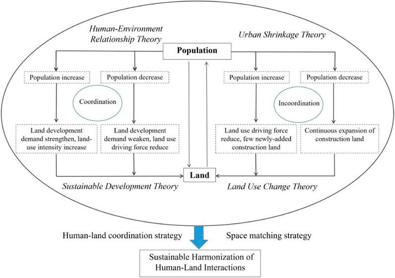
Figure 1. Theoretical analysis framework for the spatial relationship between population change and land development.
3 Materials and methods
3.1 Study area
One of China’s eight economic zones, northeast China is located in the northeast of China (Figure 2). There are different ways to define the scope of this region. Some studies defined it as the three provinces in northeast China, including Heilongjiang, Liaoning, and Jilin, while some took its scope as the three provinces, five prefecture-level city units in eastern Inner Mongolia involving Chifeng, Tongliao, etc., and some counties in northern Hebei. The northeast three provinces are relatively independent and complete administrative units that share certain similarities in their socioeconomic development, urbanization, and industrial structure features. Considering data availability, this study adopted the three provinces as the research scope consisting of 162 county-level units.
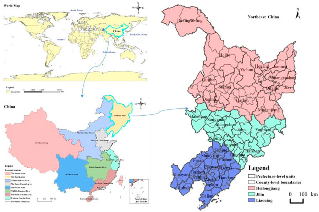
Figure 2. Spatial geographic location of Northeast China.
This region has experienced economic recession and population contraction in recent years due to the depletion of natural resources and other factors. From 2000 to 2020, the population change rate in northeast China has shown a downward trend. After 2010, there has been negative population growth, indicating a population shrinkage phenomenon. Specifically, the total population in the area studied in this article has shrunk by 11 million people between 2010 and 2020. Furthermore, the labor force change rate has also shown a negative growth after 2010, shrinking 12.6 million workers during 2010–2020. It can be seen that the total population and labor force shrinkage in northeast China in recent years require the attention of the government and academic circles.
3.2 Data sources
Population data in 2000, 2010, and 2020 mainly come from the China Population Census, which is a one-time survey of the national population in a household-by-household and person-by-person manner based on a unified method, unified project, unified questionnaire, and unified standard time points set by the state. We obtained the data through the official website of the National Bureau of Statistics of China (website: https://www.stats.gov.cn/sj/pcsj/).
The 30 m-precision land use remote sensing image data are sourced from WHU IGS Data Center (http://www.igs.gnsswhu.cn). This dataset contains multiple land use and land cover (LULC) categories, including the following main categories: Construction land, including urban land, rural residential areas, industrial and mining land, and transportation land; agricultural land, including cultivated land, gardens, forests, and grasslands; Unutilized land, including deserts, bare land, swamps, etc.; and water bodies, including rivers, lakes, and reservoirs. These categories are generated based on remote sensing image interpretation and classification algorithms that have high spatial resolution and classification accuracy and can support county-level land use analysis. Subtypes of land use intensity (e.g., residential land, industrial land, etc.) can provide a more detailed perspective and help reveal the driving effects of different economic sectors on land consumption. This type of analysis provides a deeper understanding of the internal structure of land development, especially in explaining the incongruity between population contraction and land development, and it can help identify which types of land development continue to expand despite population decline.
The county-level boundary vector surface data in our study are taken from the 2020 version of China’s administrative divisions, downloaded from the Resource and Environmental Science Data Center of the Chinese Academy of Sciences (website: https://www.resdc.cn/). It should be noted that the boundaries of many county-level units in northeast China were adjusted during 2000–2020, such as the establishment of cities from counties, districts from counties, and splitting or merging of county-level units’ townships. This article used the 2020 administrative division data as the standard and integrated the corresponding boundary, population, and boundary data of county-level units with any type of administrative division change on the Arc GIS platform to ensure the reasonable and effective horizontal and vertical comparison of research data. Specifically, taking the county-level units’ administrative boundaries of 2020 as a reference standard, it merged or split the corresponding county-level units of 2000 and 2010. After processing, 162 research units were obtained.
3.3 Study methods
This study selects two indicators for measurement and analysis to further explore the characteristics of population shrinkage in northeast China, including total population and labor population. Among them, the labor population consists of people who meet the age requirement and have the ability to work. Internationally, 15–64 is generally classified as the working age. In China, the working age of men is 16–60 years old, and that of women is 16–55. Adopting the international regulations, this study used a population aged 15–64 as the labor force. There may be two deviations in this definition. On the one hand, the labor population may continue to work after retirement, and the working-age population may be unemployed on the other hand. In view of the statistical difficulty of precisely defining the labor force population that could both reflect the distribution pattern or the shrinking characteristics of the labor force from a relatively macro perspective, this study applies this data adoption method.
3.3.1 Population change rate
This study collected total population data and calculated the labor force numbers for the whole country, northeast China, three provincial units (Liaoning, Jilin, and Heilongjiang), and 162 county-level units in 2000, 2010, and 2020. The calculated results created the total population and labor vector databases of the 162 county-level units using the attribute table association function of the vector surface data in ArcGIS software. In addition, it further calculated the total population change rate, labor change rate, labor ratio of the total population, and other indicators in the attribute table. Among them, total population change rate and labor change rate use the formula:
In Formula 1, R(t1,t2) represents the total population change rate or labor force change rate during t1 and t2; Mt1 and Mt2 represent the total population or labor in t1 and t2, respectively.
The natural breakpoint method of ArcGIS spatial analysis was used to spatially express the total population and labor force change rate and labor force ratio of total population distribution at the county scale to sum up the shrinkage features of the total population and labor force shrinkage in northeast China.
3.3.2 Calculation of land-use intensity
Land-use intensity (LUI) refers to the comprehensive utilization degree of land space in a region and is usually represented by the proportion of urban and rural construction land area in a region. Urban and rural construction land mainly includes urban land, rural residential areas, and other construction land such as industrial and mining land and transportation land. In the relevant research on the process of urban development and construction, different scholars have various understandings and interpretations of the concept and characterization indicators of land use intensity, taking into account the differences in the scope of the research area. When the scope of the research area is greater than or equal to the urban area, the intensity of land development is described by the proportion of construction land to the total land area of the urban area. When the research scope only involves urban built-up areas or urban areas, indicators such as plot ratio and building density are used to characterize the intensity of land development. Because this study was conducted at the county level, the proportion of construction land to the total land area of the county-level unit was used to characterize the study.
In this paper, the comprehensive land-use intensity index, LUI, is chosen as the main index to measure land development intensity, mainly based on the overall objective of the study and the availability of data. Comprehensive land use intensity can reflect the overall land development of a region, especially at the county level, providing an effective tool for analyzing the macroscopic relationship between population contraction and land development. In addition, the use of composite indicators also helps to simplify the analysis process, especially in the case of a large number of county-level units, providing a clearer global view.
Land-use intensity is obtained through the following steps: First, data preprocessing: we preprocessed the remote sensing image data, including geometric correction, radiation correction, and classification accuracy verification, to ensure the accuracy and consistency of the data. Second, construction land extraction: we extracted the categories of urban construction land and rural settlements from remote sensing data and combined them into construction land categories. Finally, the area is calculated: GIS software (such as ArcGIS) is used to calculate the construction land area in each county-level unit, and the ratio between it and the total area of the administrative area is calculated to obtain the LUI.
Based on the research of relevant scholars and data availability, this study defines the LUI expression as follows:
In Formula 2,
To ensure that boundary changes do not affect the calculation and comparability analysis of land use intensity from 2000 to 2020, we used the 2020 county-level administrative boundaries as the baseline for spatial matching and resampling of land use data from 2000 to 2010. Specifically, we used spatial overlay analysis and resampling techniques to unify land use data from earlier years under the 2020 boundary framework to ensure that data from different years are comparable within the same spatial scope. For county-level units where boundary adjustments occurred during the study period, we identified the details of these changes by reviewing the relevant records of changes to administrative divisions. Specifically, we merged or split county units in 2000 and 2010 according to the 2020 county unit boundaries to ensure the continuity and consistency of the data.
3.3.3 Correlation coefficient measurement method
This paper chooses correlation analysis and coupling coordination models as the main analysis methods mainly because these methods can intuitively reflect the correlation between population change and land development intensity and quantify the degree of coordination between the two, especially in the study of the typical shrinking area in northeast China. These methods can effectively reveal the complex relationship between population and land. The correlation coefficient is a measure of the degree of linear correlation between variables that is widely used in disciplines such as geography, statistics, economics, and sociolog It is generally represented by the letter r and can be expressed as follows:
where
3.3.4 Coupling coordination model
The coupling coordination model is a classic model for measuring the coupling coordination relationship between two or more systems or elements. The measurement indicators mainly involve coupling degree, coupling coordination degree, and comprehensive coordination index. The calculation formula is as follows:
In Formula 4, C represents the coupling degree between population change rate and land use intensity, with 0 < C < 1. The larger the C value, the better the coupling; f(x) and g(y) represent population change rate and land use intensity, respectively; K is the adjustment coefficient, generally 2 ≤ k ≤ 5. Considering that the research object of this study is two subsystems, the value of k is taken as 2.
In Formula 5, D is the coupling coordination between population change rate and land use intensity, with a value range of [0,1]; T is the comprehensive coordination index of the two; α and β are undetermined coefficients that characterize the importance of two systems (α+β = 1). According to domain experts’ ratings, the importance of the population system to regional socioeconomic development is slightly higher than that of the land system. Therefore, in this study, the β value of the population system is 0.6, and the α value of the land system is 0.4. Referring to the judgment criteria set by relevant scholars on coupling coordination (Shang et al., 2017), when D is higher than 0.5, it can be determined that the two types of elements are in a basic coupling coordination state, and the closer the value is to 1, the higher the coupling coordination.
4 Space–time features of a shrinking population
4.1 Shrinking features based on two indicators of total population and labor force
Shrinkage issues have garnered wide attention from both academia and policymakers, mainly focusing on total population shrinkage, while little attention has been given to labor force shrinkage, which plays an important role in regional economic and social development and urbanization. In this study, two indicators of total population and labor force were taken to analyze shrinking features. As one of the eight regions of China, northeast China is ranked the second lowest in the whole country in terms of both economic level and population size, which is also below the national average. Comparing the changes of population and labor force in northeast China with the national average level could help to grasp its situation from a macro scale. To further explore the spatio-temporal differences between the total population and labor force in the population shrinkage area, this article analyzed the total population change, labor change, and the labor ratio of the total population of the three provinces and the 162 county-level units in northeast China. According to data and related materials analysis, this study summarized the following features:
(1) Both the total population and labor force in northeast China shrank between 2010 and 2020, while the contribution of the labor force to the whole population remained at a level above the national average throughout the period. As an important indicator to detect the shrinkage of the total population or labor population, the population change rate could reflect the development trend of the total population or labor population. When the change rate is negative, it indicates that the population has contracted. Using the data from 2000 to 2020, this paper calculated the total population and labor change rate according to Formula 1. It showed that the total population and labor force change rates in northeast China remained positive from 2000 to 2010 and became negative from 2010 to 2020, signifying that the total population and labor force in northeast China have shrunk severely and need attention from related governments. However, the contribution of the labor force to the whole population in northeast China presented a level above the national average, of which labor occupied 74.8% of the total population in 2000, 76.8% in 2010, and 72.6% in 2020. The national average level has a similar change trend, but it remains lower than that of northeast China. It can be seen that the labor force ratio in northeast China is not the lowest in the whole country, although its labor population has shrunk severely. In other words, the labor population structure in northeast China might be relatively reasonable.
(2) Total population and labor population of the three provinces in northeast China were all gradually shrinking on the whole during the period of 2000–2020, but there were significant differences in the degree of contraction. The total population and labor force change rate in Liaoning, Jilin, and Heilongjiang provinces all decreased and became negative after 2010. It can be seen that the labor force in inner northeast China was also shrinking in the context of total population contraction. Among them, the total population and labor force in Heilongjiang have both shrunk faster and to a greater extent. The total population change rate was −0.18 during 2010 and 2020, and the labor population change rate was −0.026 during 2010 and 2020, which are lower than that of the other two provinces. In addition, the proportion of the labor force in the total population in Heilongjiang maintained a higher level than that of Jilin and Liaoning. For example, the labor force proportions of Heilongjiang, Jilin, and Liaoning were 74.1%, 72.7%, and 71.5% in 2020, respectively. Overall, Heilongjiang remained the largest proportion of the labor force, although it faced the most severe population contraction in northeast China. It could be seen that contraction of the total population and labor force might not necessarily affect the decline in labor share, and the labor structure might not be destroyed.
(3) Almost all (94%) of the county-level units in northeast China experienced total population contraction, and 98% experienced labor force contraction from 2000 to 2020, to different degrees. The total population change rate of 152 county-level units became negative between 2000 and 2020, while only Changchun City municipal district, Shenyang City municipal district, Dalian City municipal district, Panjin City municipal district, and 10 other city municipal districts have consistently positive population change rates. Most (159) county-level units have always had a negative labor change rate, which means county-level units with a shrinking labor force account for the vast majority of county-level units in northeast China. The number of units with total population contraction and labor contraction both significantly increased between 2010 and 2020, with only three units remaining in total population and labor growth. Furthermore, a significant difference existed in the degree of total population contraction and labor contraction between units. The total population change of some county-level units was below −50%, significantly lower than that of most cities by −20% in 2000–2010 and 2010–2020. The labor contraction exhibited similar characteristics. In addition, as shown in Figure 3, total population contraction and labor contraction have similar spatial pattern characteristics: contraction units were mainly distributed in the peripheral areas of northeast China or remote areas, especially in the peripheral areas of provincial capital cities or developed cities, indicating that the core cities may have a strong “siphon effect” on the population and labor force of surrounding cities. The closer a county-level unit is to the core city, the more severe shrinkage will be, such as Linkou County, Heishan County, Mulan County, and Bayan County, etc.
(4) The proportion of labor in most county-level units in the total population maintained a relatively high level, while the total population and labor force of most units experienced varying degrees of contraction. During 2000–2010, the labor ratio of the total population of the 162 county-level units in northeast China increased, but they decreased during 2010–2020. However, the labor ratios in most units are higher than the national average for the same period. Some of the 162 county-level units’ labor ratio of the total population accounted for more than 80% in 2010, such as Huichun City, Mohe City, Qianan County, and Tonghua County, and 96% of the units’ labor ratio accounted for more than 75% (as can be seen from Figure 4). This showed that the proportion of labor in the total population of the county-level units in northeast China still remained relatively high, although most of them have experienced the total population and labor shrinking problem, implying that labor still had a benign supporting role for production activities.
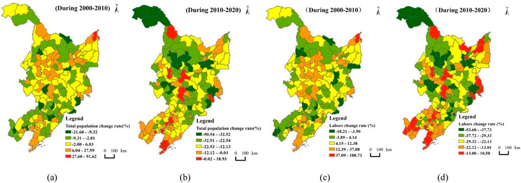
Figure 3. Total population and labor change rates in Northeast China on a county-level scale in 2000–2020. (a) Total population (2000–2010), (b) total population (2010–2020), (c) Labor (2000–2010), and (d) labor (2010–2020).
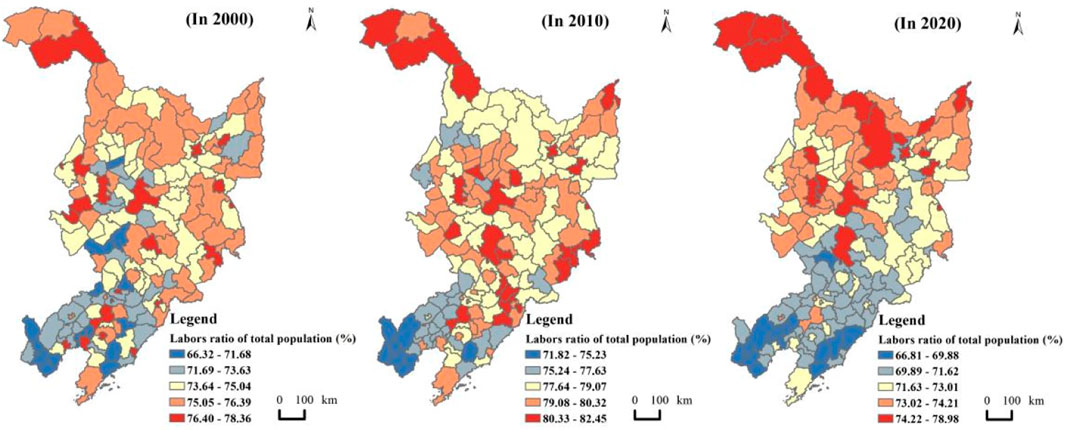
Figure 4. Labor ratio of the total population in Northeast China on the county-level scale during 2000–2020.
4.2 Shrinkage type difference
The labor force, functioning as both producers and consumers, is the core group of the population system, and its growth is crucial to urban development. From the statistical results, this study found that the labor of some shrinking county-level units is showing growth, although most are shrinking. In other words, there is a certain inconsistency between the trend of the labor population and that of the total population. To explore this inconsistency in depth, this study summarized four shrinkage types of 162 county-level units in northeast China based on the changes in the total population and the labor population. This could help to explain the current development vitality status of county-level units and the health status of population structure, laying an important foundation for formulating the future economic policy, social resource allocation, and population policy or labor policy as a shrinking city or county may still have advanced vitality and sustainability if its labor forces increase. In this paper, the four types include:
(1) Total population shrinks while the labor force decreases, which is called absolute shrinkage type. This type indicates that while the total population is declining, the labor supply is also decreasing, limiting the city’s development vitality. This could be caused by resource depletion, ecological degradation, economic decline, and other factors leading to a large-scale population loss.
(2) Total population shrinks while the labor force increases, called labor-growth shrinkage type. This type suggests that despite the overall population decline, the city still retains development vitality due to the growth of the working-age population. This may result from long-term low birth rates and aging, which reduce the total population. At the same time, the city actively adjusts its industrial structure and increases employment opportunities, attracting the return of the labor population or an influx of migrant workers.
(3) The total population increases while the labor force decreases, named labor-loss growth type, indicating that although the total population is increasing, the population energy is continuously declining and possibly facing population structure imbalances. This may be mainly due to the downturn in regional economic development and the low vitality of enterprises, resulting in a poor employment environment and outflow of the labor force.
(4) Total population increases while the labor force rises, named absolute growth type, reflecting the city’s increasing population agglomeration and development vitality, with a balanced and continuously optimized population structure. It suggests that the city’s socioeconomic development may continue to improve, and policies related to employment, education, and social welfare are being optimized, indicating that the city’s scale will continue to expand in the future. Four examples are shown in Figure 5.
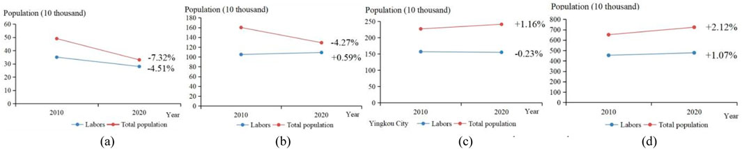
Figure 5. Examples of four shrinkage types. (a) Absolute shrinkage type, (b) labor-growth shrinkage type, (c) labor-loss growth type, and (d) absolute growth type.
This study calculated the total population change rate and labor change rate during 2000–2010 and 2010–2020 and determined the type division results shown in Figure 6. It showed that the absolute shrinkage type and the absolute growth type accounted for more than half of all county-level units during the two periods. They are the two main types, indicating that the changing trends in the labor force and total population are relatively consistent on the whole. Specifically, 84 county-level units were identified as absolute growth type during 2000–2010, while the units of this type sharply decreased to three during 2010–2020, which is mainly because some of the 84 units experienced resource exhaustion, leading to economic recession. Most absolute growth type county-level units are economically developed with stable agglomeration capacity or achieve further growth due to successful economic transformation, including Changchun City municipal district, Shenyang City municipal district, Dalian City municipal district, Yushu County, Mulan County, and Bin County This phenomenon is a realistic response to the shrinkage problem throughout northeast China.
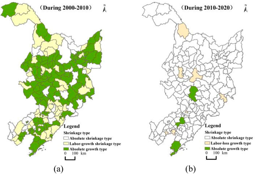
Figure 6. Shrinkage type of county-level units in northeast China. (a) Shrinkage type in 2010 and (b) shrinkage type in 2020.
Thirty-one county-level units were classified as absolute shrinkage type during 2000–2010, and they increased to 74 units in the period of 2010–2020, with an overall feature of expansion from the periphery of northeast China to the interior, demonstrating that labor shrinkage is the more common trend in the region. Figure 6 shows that an increasing number of county-level units in northeast China during 2010–2020 are undergoing both population shrinkage and development vitality decay. From the perspective of location distribution, they were mainly situated in the peripheral areas of the northeast economic zone in the first period, expanded and extended to the internal area, and spread to nearly the whole region in the second period. Many of the absolute shrinkage units during 2000–2010 are in the mountains and away from main traffic routes; as a result, their economic systems are relatively closed, such as Luobei county in Hegang, Mishan City in Jixi, etc.
The labor-growth shrinkage type appeared in the 2000–2010 period, and labor-loss growth type appeared in the 2010–2020 period, which typically represents inconsistency between the labor population and the total population. This is a special phenomenon that scholars have paid little attention to at present. The labor-growth shrinkage type units are more common than the labor-loss growth type units, which are located between absolute shrinkage type and absolute growth type, involving Tonghua County, Liuhe County, Tahe County, Bayan County, etc. They are influenced by the strong forces of the absolute shrinkage type and absolute growth type around them, so that part of their population or labor moves to the surrounding strong population-aggregated units, and some of them absorb certain flows from the neighboring strongly contracted areas. It can be said that they stand in the middle of strong population outflow areas and strong population inflow areas, which have a buffering effect. This is an important reason for explaining the inconsistency in the change trend between the labor force and the total population.
It should be noted that the recovery of the labor force is not achieved overnight, and policies need to be appropriately adjusted according to shrinkage type. Cities with absolute shrinkage should focus on replacing leading industries to promote economic output. Cities with labor-growth shrinkage whose total population shrinks while labor rises should concentrate on improving infrastructure to attract school-age children and their parents to increase the total population. Labor-loss growth type cities where the total population increases while the labor force decreases should aim at promoting enterprise projects to expand employment and attract labor.
5 Spatial relationship between population shrinkage and land development
5.1 Land use features
Based on Formula 2 and 30 m-precision land use remote sensing image data, this study calculated the land-use intensity (LUI) of 162 county-level units in northeast China, as shown in Figure 7. The features it found were as follows.
(1) The land-use intensity of county-level units in northeast China gradually increased from 2000 to 2020, and more than half of them improved their land-use rate. The average LUI increased from 0.067 in 2000 to 0.081 in 2010 and 0.095 in 2020. Among them, Fuxin City municipal district’s LUI grew the most, increasing by 0.164 in 2020 compared with 2000, while Changbai Korean Autonomous County’s LUI grew the least, only increasing by 0.002 over 20 years. The municipal districts of Changchun, Harbin, and Shenyang, which are the three provincial capital cities in northeast China, have respectively increased by 0.073, 0.062, and 0.123 during 2000–2020. Furthermore, it is worth noting that the rate of land development in more than 50% of 162 county-level units in northeast China has improved, and the vast majority of them are county-level units with severe population shrinkage. For instance, the total population of Mingshui county shrank by 122,000 people from 2010 to 2020, with a population change of −38.17%, while its LUI increased by 59.5%. It implied that a typical paradox of population loss and land-use expansion existed in northeast China, which is not beneficial for the coordinated development of human–land relationships.
(2) Significant spatial differences exist in the land-use intensity among county-level units in northeast China, that the LUI values in the western and southern regions are generally higher than that in the eastern and northern regions, and the overall pattern remains relatively stable. As seen in Figure 7, county-level units in the western and southern regions of northeast China have obviously higher LUI values than those in other regions, especially in areas centered around Daqing, Shenyang, and Dalian, such as Zhaoyuan County, Zhaozhou County, Fushun County, Dengta City, Zhuanghe City, and Gaizhou City. Meanwhile, several county-level units in the northeast region have relatively high LUI, significantly higher than other surrounding county-level units in the eastern and northern regions, including Jiamusi City municipal district, Shuangyashan City municipal district, Hegang City municipal district, Qitaihe City municipal district, Jixi City municipal district, Huachuan County, Jixian County, etc. Moreover, these units have further increased their LUI between 2000 and 2020. Overall, this spatial feature is relatively stable, almost without much change in the past 20 years. In addition, Anshan City municipal district (0.008), Daqing City municipal district (0.007), and Daan City municipal district (0.007), which had a fast LUI growth rate during 2000–2010, experienced a great decline in LUI growth during 2010–2020, recording increases of only 0.005, 0.004 and 0.002, respectively. This indicates that in the past decade, due to the depletion of mineral resources or the protection of natural resources and other reasons, the urban development of some resource-based county-level units has been significantly limited.
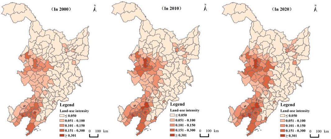
Figure 7. Land-use intensity in northeast China in 2000 and 2020.
5.2 Spatial relationship
To explore the correlation between population shrinkage and land development from multiple dimensions, this study measured the correlation coefficient based on Equation 3 between total population change and LUI change, as well as the correlation coefficient between labor force change and LUI change. At the same time, this study used the coupling coordination model to measure the coupling coordination degree of the population change indicator and land use intensity change indicator. The research findings are as follows:
(1) The population changes in most county-level units are negatively correlated with the LUI change. Specifically, 88.9% of county-level units’ total population changes are negatively correlated with LUI changes, and 90.1% of county-level units’ labor force changes are negatively correlated with LUI changes. It can be seen that in the context of population shrinkage, the amount of land development has actually increased in most counties and cities in northeast China, which may result in the waste of land resources or the imbalance of human–land relationships. Among them, the absolute value of the correlation coefficient between total population change and LUI change in 44 county-level units, including Jiayin County, Keshan County, Dongning City, Changhai County, Tieling County, etc., is close to 1, reflecting a relatively strong negative correlation. These counties and cities may need more attention from the government, with a focus on conducting further on-site research and problem analysis on population changes and land development and taking measures to make timely adjustments.
(2) The small number of county-level units with a positive correlation between population change and LUI change are mainly distributed around core cities such as Harbin, Changchun, Shenyang, Dalian, etc., and show a spatial characteristic of decreasing from the center to the periphery. The correlation coefficients between the total population change and LUI change in 18 county-level units, including Harbin, Changchun, Shenyang, Dalian, Daqing, Tieling, Heihe, Panjin City municipal districts and other counties, are all greater than 0, and the absolute values of their correlation coefficients are almost all above 0.5. These units are the central cities of their respective regions and are generally able to gather population from surrounding areas, resulting in population growth or lower shrinkage levels. At the same time, land development continues to advance, so population and land development tend to be generally coordinated. The results shown in Figure 8 imply that the correlation coefficient of county-level units gradually decreases as the distance from these central cities increases. Overall, the match between population change and LUI change is stronger in regional central cities, and there is a certain degree of blind expansion in small and medium-sized cities.
(3) The coupling coordination degree between population change and land use intensity change in most county-level units in northeast China is below 0.5, indicating an uncoupled coordination state. Only 28 county-level units showed a coupling coordination state of total population and land during 2010–2020, whose coupling coordination degree D is higher than 0.5 and the same as that of the labor force and land. This is relatively consistent with the analysis results of the correlation coefficient, further indicating that the pace of population change and land development in northeast China might not be coordinated. From the spatial distribution pattern, counties and cities with high coupling coordination degrees are mainly concentrated near central cities such as Harbin, Changchun, Shenyang, Dalian, and Daqing, which is relatively matched with the spatial distribution pattern of correlation coefficients. It shows that the more developed the economy and the stronger the comprehensive strength, the more harmonious the relationship between humans and land is in northeast China. The government in northeast China needs to focus on human–land relationships in small and medium-sized cities as well as relatively underdeveloped county-level units.
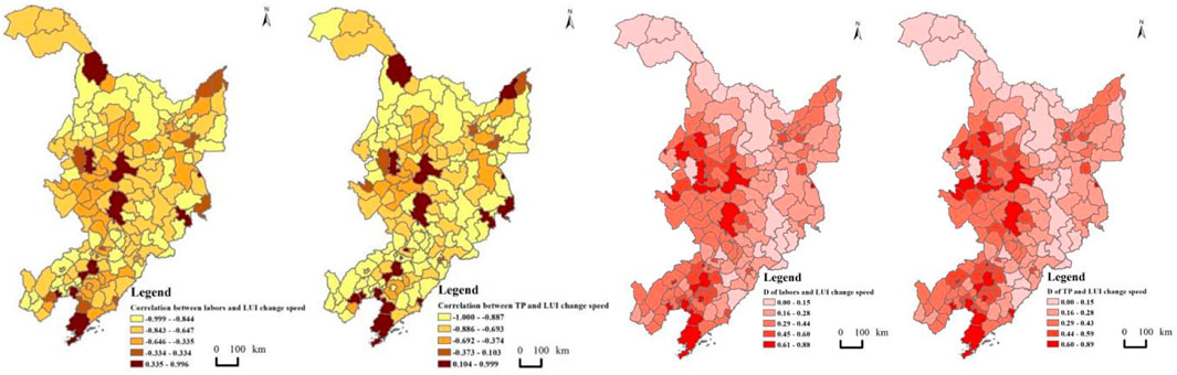
Figure 8. Correlation and coupling coordination degree between population and LUI in northeast China.
6 Discussion
The findings of this study reveal a significant paradox in northeast China: widespread population shrinkage coexists with continuous land expansion, a phenomenon that contrasts sharply with patterns observed in shrinking cities in Europe and North America (Wiechmann and Pallagst, 2012; Martinez-Fernandez et al., 2016). While international studies have documented population loss leading to reduced land development demand and the repurposing of vacant land (Haase et al., 2014; Bontje, 2004), the situation in northeast China is characterized by persistent land expansion despite severe population decline. This discrepancy highlights the unique socioeconomic and institutional context of China’s shrinking cities, particularly the reliance on land finance and the growth-oriented urban planning paradigm (Jiang, 2021).
6.1 Population shrinkage and spatial heterogeneity
The severe population shrinkage observed in Northeast China, particularly in Heilongjiang Province, aligns with existing studies that highlight the region’s demographic challenges, including aging populations, outmigration, and declining birth rates (Xie et al., 2022). However, this study extends the understanding of population shrinkage by differentiating between total population and labor force dynamics. The higher proportion of the labor force relative to the national average, despite overall population decline, suggests that labor productivity and economic activities may still be sustained in the short term. This finding challenges the conventional assumption that population shrinkage invariably leads to economic stagnation, as noted by Martinez-Fernandez et al. (2016) in the context of shrinking cities globally.
The spatial heterogeneity of population shrinkage types, particularly the emergence of labor-loss growth types (e.g., Harbin, Daqing, and Panjin), underscores the need for nuanced policy interventions. These areas, characterized by total population growth but labor force decline, may face unique challenges in maintaining economic vitality. The phenomenon of labor-loss growth type has received limited attention in the literature, and its identification in this study calls for further investigation into the underlying causes, such as aging populations or mismatches between labor demand and supply.
6.2 Paradox of population loss and land expansion
The paradoxical phenomenon of population loss coexisting with land-use intensity (LUI) increase is a striking finding of this study. This aligns with the global trend of “peripheralization” in shrinking regions, where urban cores continue to expand despite population decline (Haase et al., 2014). In northeast China, this pattern is particularly pronounced in the western and southern regions, such as Daqing and Shenyang, where rapid land development contrasts sharply with severe population loss. This imbalance reflects a potential misalignment between land-use policies and demographic realities, leading to inefficient land resource utilization and potential environmental degradation.
The increase in LUI in shrinking regions may be driven by local government reliance on land-based financing and infrastructure development as a strategy to stimulate economic growth (Ye and Wu, 2014). However, this approach risks exacerbating the mismatch between population and land resources, as highlighted by the negative correlation between population change and LUI change in 88.9% of county-level units.
6.3 Human–land coordination and regional disparities
The uncoupled coordination relationship between population change and land development in most county-level units underscores the challenges of achieving sustainable human–land relationships in shrinking regions. The stronger coupling coordination observed in regional central cities (e.g., Harbin, Changchun, and Shenyang) suggests that economic vitality and comprehensive strength play a critical role in harmonizing population and land dynamics. This finding supports the “core-periphery” theory, which posits that central cities exert a “siphon effect” on surrounding areas, attracting population and resources while leaving peripheral regions more vulnerable to shrinkage (Friedmann, 1966). However, the spatial gradient of coupling coordination, decreasing from central cities to peripheral areas, highlights the need for targeted policies to address disparities in human–land relationships. Small and medium-sized cities and underdeveloped county-level units, where blind land expansion is prevalent, require tailored strategies to balance population retention and land-use efficiency.
6.4 Policy implications
The concept of “smart shrinkage,” which advocates for targeted land use planning and infrastructure downsizing, has been proposed as a potential strategy for aligning land development with population trends (Pallagst et al., 2011). However, the implementation of such strategies in the Chinese context remains challenging due to institutional barriers and the lack of a comprehensive policy framework for managing population–land mismatches (Hartt and Hackworth, 2020). In view of this, land-use policies need to be recalibrated to reflect demographic realities, with a focus on curbing inefficient land expansion and promoting compact urban development. Policymakers should prioritize strategies to address labor-force decline, particularly in areas exhibiting labor-loss growth type. This may include promoting enterprise projects, enhancing vocational training, and creating incentives for labor retention and attraction. Further, regional development strategies should aim to strengthen the economic resilience of peripheral areas, reducing their dependence on central cities and fostering more balanced human–land relationships.
6.5 Limitations
This study also had certain limitations. For instance, the population and land use data were at the county level, which cannot depict the population and land use changes at finer scales such as township or village levels. Furthermore, it did not distinguish between shrinkage resulting from outmigration and shrinkage caused by population aging and death surplus due to little official authoritative data on the outflow or inflow of population at the county level. Therefore, in future studies aiming to deepen the research on population shrinkage in northeast China, it may be beneficial to use interpolation and partition adjustment to estimate relevant data and to further interpret and analyze the shrinkage process and features. In addition, the importance of quantitatively measuring and analyzing the influence mechanism of population change and land development spatial relationship is constantly highlighted, and future research needs to continue to deepen and improve the analysis of influence factor and excavate the mechanism behind the spatial relationship in the new period, to lay some foundation for orderly coordinating human–land relationships. Finally, the study is limited to northeast China, and its findings may not directly apply to other shrinking regions with different socioeconomic and institutional contexts. Comparative studies across regions and countries could provide a more comprehensive understanding of the dynamics of population shrinkage and land development.
7 Conclusion
Population and land are important fundamental elements in the regional system of human–land relationships that complement each other (Dong and Xue, 2022). In the process of urbanization, coordinated human–land development is an inherent requirement for optimizing the regional system of human–land relationships. This study, based on the total population indicator and labor force indicator, employed population change to analyze the population shrinkage features on different administrative unit scales in northeast China. Furthermore, it calculated the LUI of 162 county-level units in northeast China and analyzed their spatial features. Finally, it explored the spatial relationship between population shrinkage and land development based on the correlation coefficient measurement method and coupling coordination model. Overall, we have identified several key findings that contribute to the understanding of human–land relationships in shrinking regions.
(1) Northeast China has experienced severe population shrinkage in terms of both the total population and the labor force, with a notable decline after 2010. Despite this, the labor force’s contribution to the total population remained above the national average, indicating a relatively stable labor structure. However, the spatial heterogeneity of population shrinkage types, including absolute shrinkage, labor-growth shrinkage, labor-loss growth, and absolute growth, highlights the complexity of demographic changes in the region. This diversity in shrinkage types underscores the need for differentiated policy interventions to address the varying development trajectories of different county-level units.
(2) The study reveals a paradoxical phenomenon of population loss coexisting with land-use expansion. Despite a significant population decline, LUI in most county-level units has increased, driven by local government reliance on land finance and speculative real estate investments. This mismatch between population dynamics and land development has led to inefficiencies in land resource utilization, with potential long-term environmental and economic consequences. The negative correlation between population change and land-use intensity change in most county-level units further emphasizes the need for more sustainable land-use planning.
(3) The coupling coordination analysis indicates that population change and land development are largely uncoupled in most areas, particularly in small and medium-sized cities. Regional central cities, such as Harbin, Changchun, and Shenyang, exhibit stronger coordination between population and land development, and were generally able to gather population from surrounding areas while land development continues to advance, reflecting their economic vitality and ability to attract population and resources. However, peripheral regions face greater challenges in achieving balanced human–land relationships, necessitating targeted policies to address disparities and promote sustainable development, especially in response to their blind land expansion.
In conclusion, this study highlights the complex interplay between population shrinkage and land development in northeast China, providing some valuable insights for policymakers and urban planners. By addressing the spatial mismatches and promoting sustainable land-use practices, it is possible to achieve a more harmonious relationship between population dynamics and land development, ultimately contributing to the long-term sustainability of shrinking regions. Future research should continue to explore the underlying mechanisms of population–land relationships and develop more nuanced policy frameworks tailored to the unique challenges of shrinking cities and regions.
Data availability statement
The raw data supporting the conclusions of this article will be made available by the authors, without undue reservation.
Ethics statement
Ethical review and approval were not required for the study on human participants in accordance with the local legislation and institutional requirements. Written informed consent from the [patients/ participants OR patients/participants legal guardian/next of kin] was not required to participate in this study in accordance with the national legislation and the institutional requirements.
Author contributions
XW: formal analysis, funding acquisition, resources, supervision, visualization, writing–original draft, and writing–review and editing. JH: data curation, formal analysis, methodology, software, writing–original draft, and writing–review and editing. SZ: methodology, project administration, supervision, visualization, writing–original draft, and writing–review and editing. RH: conceptualization, investigation, validation, writing–original draft, and writing–review and editing.
Funding
The author(s) declare that financial support was received for the research, authorship, and/or publication of this article. This research was funded by the National Natural Science Foundation of China (42401287) and the Social Science Foundation of Jiangsu Province (22SHC003).
Conflict of interest
The authors declare that the research was conducted in the absence of any commercial or financial relationships that could be construed as a potential conflict of interest.
Generative AI statement
The authors declare that no Generative AI was used in the creation of this manuscript.
Publisher’s note
All claims expressed in this article are solely those of the authors and do not necessarily represent those of their affiliated organizations, or those of the publisher, the editors and the reviewers. Any product that may be evaluated in this article, or claim that may be made by its manufacturer, is not guaranteed or endorsed by the publisher.
References
Baron, M., Cunningham-Sabot, E., Grasland, C., Riviere, D., and van Hamme, E. (2010). Villes et régions européennes en décroissance. Paris, Hermès: Maintenir la Cohésion Territorial.
Beyer, E., Hagemann, A., Rieniets, T., and Oswalt, P. (2006). Atlas of shrinking cities. Hatje Cantz.
Bontje, M. (2004). Facing the challenge of shrinking cities in East Germany: the case of Leipzig. GeoJournal 61 (1), 13–23. doi:10.1007/s10708-004-0843-7
Cheng, K. M., Gao, D. D., and Hong, Z. Y. (2024). How does land allocation affect spatial distribution of urban population. China Ind. Econ. (9), 24–42. doi:10.19581/j.cnki.ciejournal.2024.09.002
Deng, T. T., Liu, S., and Hu, Y. K. (2022). Can tourism help to revive shrinking cities? An examination of Chinese case. Tour. Econ. 28 (6), 1683–1691. doi:10.1177/13548166211002295
Dobre, A. M. (2018). Adrian Marius, Migration within the labor market, a balancing force, and a propeller for economic growth. Available online at: http://www.contributors.ro/global-europa/.
Dong, C. Y., and Xue, D. Q. (2022). Evolution of construction land and its correlation with population in villages and towns in China. Geogr. Geo-Information Sci. 38 (5), 96–103. doi:10.3969/j.issn.1672-0504.2022.05.013
Emeka, E. T., Okenyi, C. N., and Ibrahim, A. (2024). Development effects of industrialization, labor force participation and electrification on productive capacity in Africa: a panel data investigation. J. Int. Trade and Econ. Dev., 1–21. doi:10.1080/09638199.2024.2321236
Feng, Z. X., Li, J. X., Wang, S. J., Yang, Z. P., and Ji, G. F. (2023). Dynamic evolution and influencing factors of urban vitality of shrinking cities in Northeast China. Sci. Geogr. Sin. 43 (5), 774–785. doi:10.13249/j.cnki.sgs.2023.05.002
Fernandez, B., and Hartt, M. (2022). Growing shrinking cities. Reg. Stud. 56 (8), 1308–1319. doi:10.1080/00343404.2021.1975032
Gao, S. Q., and Ryan, B. D. (2021). Implementation challenges of state-led redevelopment in shrinking cities: case study of Shantytown redevelopment in Yichun, Northeast China. J. Urban Plan. Dev. 147 (1). doi:10.1061/(asce)up.1943-5444.0000661
Haase, A., Rink, D., Grossmann, K., Bernt, M., and Mykhnenko, V. (2014). Conceptualizing urban shrinkage. Environ. Plan. A Econ. Space 46 (7), 1519–1534. doi:10.1068/a46269
Haase, D., Kabisch, S., Haase, A., Andersson, E., Banzhaf, E., Baró, F., et al. (2017). Greening cities–To be socially inclusive? About the alleged paradox of society and ecology in cities. Habitat Int. 64, 41–48. doi:10.1016/j.habitatint.2017.04.005
Hartt, M., and Hackworth, J. (2020). Shrinking cities, shrinking households, or both? Int. J. Urban Regional Res. 44 (6), 1083–1095. doi:10.1111/1468-2427.12713
Hu, Y. K., Wang, Z. Y., and Deng, T. T. (2021). Expansion in the shrinking cities: does place-based policy help to curb urban shrinkage in China? Cities 113, 103188. doi:10.1016/j.cities.2021.103188
Huang, Y. C., Hu, J. Y., Leng, J. J., Liu, X. Y., Zhang, Z. Y., and Zhang, C. X. (2024). Forecasting land use-population-economy synergy in non-central urban areas of Beijing. Bull. Surv. Mapp. (8), 165–171. doi:10.13474/j.cnki.11-2246.2024.0829
Jiang, L., Deng, X., and Seto, K. C. (2012). Multi-level modeling of urban expansion and cultivated land conversion for urban hotspot counties in China. Landsc. Urban Plan. 108 (2-4), 131–139. doi:10.1016/j.landurbplan.2012.08.008
Jiang, X. H. (2021). The triple logic of urban shrinking caused by spatial mismatch:Institutional space displacement, policy space paradox and behavior space imbalance. Hum. Geogr. 36 (6), 87–95. doi:10.13959/j.issn.1003-2398.2021.06.010
Karp, D. N. (2024). Typologies of population change: an analysis of growing, shrinking, and left behind places in the US. New York: State University of New York at Buffalo.
Labosse, L. (2010). Attractivité des territoires: 14 types de zones d’emploi. in La France et ses régions.
Li, H., and Mykhnenko, V. (2018). Urban shrinkage with Chinese characteristics. Geogr. J. 184 (4), 398–412. doi:10.1111/geoj.12266
Lin, L. M. (2019). Review of “research on population development in Northeast China”: number theory and bottom. Popul. J. 41 (2), 113.
Liu, Z., Li, W., and Liu, S. H. (2024). Effects of regional population shrinkage on economic growth and the underlying mechanism. Geogr. Res. 43 (4), 949–965. doi:10.11821/dlyj020230622
Ma, X. S., Yan, Q. W., Pan, Q. K., Chen, X., and Li, G. (2023). Identification and classification of urban shrinkage in Northeast China. Land 12 (6), 1245. doi:10.3390/land12061245
Ma, Z. P., Li, C. G., and Zhang, J. (2020). Understanding urban shrinkage from a regional perspective: case study of Northeast China. J. Urban Plan. Dev. 146 (4). doi:10.1061/(asce)up.1943-5444.0000621
Martinez-Fernandez, C., Audirac, I., Fol, S., and Cunningham-Sabot, E. (2012). Shrinking cities: urban challenges of globalization. Int. J. Urban Regional Res. 36 (2), 213–225. doi:10.1111/j.1468-2427.2011.01092.x
Martinez-Fernandez, C., Weyman, T., Fol, S., Audirac, I., Cunningham-Sabot, E., Wiechmann, T., et al. (2016). Shrinking cities in Australia, Japan, Europe and the USA: from a global process to local policy responses. Prog. Plan. 105, 1–48. doi:10.1016/j.progress.2014.10.001
Meng, X. F., and Long, Y. (2022). Shrinking cities in China: evidence from the latest two population censuses 2010-2020. Environ. Plan. A- Econ. Space 54 (3), 449–453. doi:10.1177/0308518x221076499
Nijman, J., and Wei, Y. D. (2020). Urban inequalities in the 21st century economy. Appl. Geogr. 117, 102188. doi:10.1016/j.apgeog.2020.102188
Pallagst, K., Fleschurz, R., and Said, S. (2017). What drives planning in a shrinking city? Tales from two German and two American cases. Town Plan. Rev. 88 (1), 15–28. doi:10.3828/tpr.2017.3
Pallagst, K., Wiechmann, T., and Martinez-Fernandez, C. (2011). Shrinking Cities: international perspectives and policy implications. New York: Routledge.
Qiao, W. Y., Yin, S. G., and Huang, X. J. (2024). Assessing the imbalances in growth between urban land and urban population and the influencing factors: an allometric growth perspective. Land 13 (10), 1657. doi:10.3390/land13101657
Ren, Y. J., Yang, J. X., Zhang, Z., Zhao, Z. B., Wang, J. R., Wang, Y. G., et al. (2023). Urbanization of county in China: differentiation and influencing factors of spatial matching relationships between urban population and urban land. China Land Sci. 37 (12), 92–103. doi:10.11994/zgtdkx.20231121.154337
Ribant, M., and Chen, X. W. (2020). A typology of US shrinking cities. Prof. Geogr. 72 (1), 152–164. doi:10.1080/00330124.2019.1633366
Schmidt, S. (2013). Sprawl without growth in eastern Germany. Urban Geogr. 32 (1), 105–128. doi:10.2747/0272-3638.32.1.105
Seto, K. C., and Ramankutty, N. (2016). Hidden linkages between urbanization and food systems. Science 352 (6288), 943–945. doi:10.1126/science.aaf7439
Shang, T. T., Hu, S. Y., and Tang, X. (2017). Spatial and temporal characteristics of coupling coordination between population and land urbanization in China from 2005 to 2015. Resour. and Industries 19 (6), 8–16. doi:10.13776/j.cnki.resourcesindustries.20171228.002
Wang, C. F., Zhu, X., and Jian, J. (2024). Relationship between population distribution and land use on the global scale. Nat. Resour. Inf. (2), 170–178.
Wang, Q., Xin, Z. L., and Niu, F. Q. (2022). Analysis of the spatio-temporal patterns of shrinking cities in China: evidence from nighttime light. Land 11 (6), 871. doi:10.3390/land11060871
Wang, X. Y., and Long, Y. (2023). Future shrinking cities on the globe: a projection map for 2020-2100 based on global gridded population dataset. Environ. Plan. B-Urban Anal. City Sci. 50 (7), 1994–1997. doi:10.1177/23998083231186153
Wiechmann, T., and Bontje, M. (2015). Responding to tough times: policy and planning strategies in shrinking cities. Eur. Plan. Stud. 23 (1), 1–11. doi:10.1080/09654313.2013.820077
Wiechmann, T., and Pallagst, K. M. (2012). Urban shrinkage in Germany and the USA: a comparison of transformation patterns and local strategies. Int. J. Urban Regional Res. 36 (2), 261–280. doi:10.1111/j.1468-2427.2011.01095.x
Wolff, M., Fol, S., Roth, H., and Cunningham-Sabot, E. (2017). Is planning needed? Shrinking cities in the French urban system. Town Plan. Rev. 88 (1), 131–145. doi:10.3828/tpr.2017.10
Wu, Y. F., Liu, Y. C., and Li, Y. R. (2018). Spatio-temporal coulpling of demographic-landscape urbanization and its driving forces in China. Acta Geogr. Sin. 73 (10), 1865–1879. doi:10.11821/dlxb201810004
Xie, M., Feng, Z., and Li, C. (2022). How does population shrinkage affect economic resilience? A case study of resource-based cities in Northeast China. Sustainability 4 (6), 3650. doi:10.3390/su14063650
Xu, G., and Xiao, R. (2021). The trends and issues of land urbanization and population urbanization in China. China Land (9), 11–13. doi:10.13816/j.cnki.ISSN1002-9729.2021.09.04
Ye, L., and Wu, A. M. (2014). Urbanization, land development, and land financing: evidence from Chinese cities. J. Urban Aff. 36 (Suppl. 1), 354–368. doi:10.1111/juaf.12105
Keywords: population shrinkage, labor force, land development, spatial relationship, Northeast China
Citation: Wang X, Hu J, Zhao S and Hu R (2025) Spatial relationship between population shrinkage and land development in northeast China. Front. Environ. Sci. 13:1522999. doi: 10.3389/fenvs.2025.1522999
Received: 05 November 2024; Accepted: 24 February 2025;
Published: 19 March 2025.
Edited by:
Lingli Qing, Guangzhou College of Commerce, ChinaReviewed by:
Ping Liu, State Grid Jiangsu Electric Power Co., LTD, ChinaYan Sun, Beijing Forestry University, China
Copyright © 2025 Wang, Hu, Zhao and Hu. This is an open-access article distributed under the terms of the Creative Commons Attribution License (CC BY). The use, distribution or reproduction in other forums is permitted, provided the original author(s) and the copyright owner(s) are credited and that the original publication in this journal is cited, in accordance with accepted academic practice. No use, distribution or reproduction is permitted which does not comply with these terms.
*Correspondence: Shen Zhao, emhhb3MuMTRzQGlnc25yci5hYy5jbg==