 Zhefu Chen
 Yang Liu
 Duanlv Chen1*
94% of researchers rate our articles as excellent or good
Learn more about the work of our research integrity team to safeguard the quality of each article we publish.
Find out more
ORIGINAL RESEARCH article
Front. Environ. Sci. , 17 June 2024
Sec. Land Use Dynamics
Volume 12 - 2024 | https://doi.org/10.3389/fenvs.2024.1395557
Background and objectives: Land use and land cover change (LULCC) directly affects the human living environment and economic society by influencing ecosystem services. This study explores the complex relationship between LULCC and ecosystem services in the Dongting Lake region of China.
Methods: The analysis incorporates the transfer matrix analysis of LULCC, ecosystem service value (ESV) accounting, Mann–Kendall mutation test, gray correlation, and path analysis. This study explored the spatial and temporal characteristics of LULCC and ecosystem services and revealed the comprehensive impacts of LULCC on ecosystem services from the perspective of factor interactions.
Findings: The findings reveal that open water (OW) area and farmable land are the dominant land use types transferring in and out of the study area, with significant interconversion observed among open water area, wetland (WL), arable land (AL), and forest land (FL). Water conservation, waste disposal, climate regulation, and biodiversity conservation emerge as the most crucial ecosystem services in the study area. The study identifies consistent patterns of abrupt changes in LULCC and ESV across six analyzed time periods. Forest land exhibits the most substantial direct influence on climate regulation, gas exchange, soil formation and protection, conservation of biodiversity, raw materials, and recreation and leisure. Additionally, forest land, wetland, arable land, and open water area contribute significantly to the total ESV, with forest land being the dominant factor influencing the spatial differentiation of ecosystem services in the Dongting Lake region.
Conclusion: The research reveals the consistency of ecosystem services and LULCC trends in the Dongting Lake area. LULCC is a complex process influenced by multiple factors, in which the conversion between ecological and non-ecological land use has a significant impact, and the complex coupling and coordination among LULCC drivers together influence ecosystem services. Furthermore, LULCC alters the structure and scale of ecosystems, resulting in alterations in the ESV.
Land use and land cover change (LULCC) is a critical aspect of global ecological change (Munthali et al., 2020), resulting from both natural processes and anthropogenic activities (He et al., 2019; Niu and Jiang, 2021). It is one of the most significant impacts of human activities on ecosystem services (Li et al., 2018; Liu et al., 2019; Dar and Dar, 2024). The escalating conflict between growing demands and resource availability necessitates the integration of ecosystem service functions and land use planning to foster sustainable regional development and ecological environment conservation (Yin et al., 2018). LULCC has garnered significant attention due to its profound impact on ecological dynamics (Esfandeh et al., 2021; Li et al., 2023).
Studies on the LULCC have primarily focused on the processes, mechanisms, and future trends (Dar et al., 2020; Shang et al., 2024). The ecosystem service value (ESV) encompasses the diverse environmental conditions and services provided by ecosystems, which directly or indirectly sustain human wellbeing through their structures, processes, and functions (Yin et al., 2018). LULCC alters the ecosystems hosted by land, consequently impacting the service functions they provide (Bai et al., 2017). As a result, the ESV changes (Fu and Zhang, 2014; Aimaitikali Wumaieraili, 2021; Gascoigne et al., 2011; Wang et al., 2022). There has been extensive research on the influences of LULCC on the ESV at local and global levels, primarily focusing on the influence of land use types, spatial patterns, and temporal changes on ecosystem services at various scales (Radford and James, 2013; Islam et al., 2015; Mengistie et al., 2018), including forest land (FL) (Kassun et al., 2024), arable land (AL) (Panwar et al., 2022), and wetland (WL) (Rashid et al., 2022) ecosystems. A range of research methods were used, including land use transition analysis (Liu et al., 2023), hot spot analysis (Guo et al., 2019), choice experiment-based approaches (Shi et al., 2016), remote sensing technology analysis (Yang, 2015), and improved hybrid frog-jumping algorithms (Guo et al., 2016). However, there are considerable variations in the quantitative changes of different land use types, the spatial attributes of LULCC, and the impact of land use intensity on ecosystem services. The relationship between LULCC and ecosystem services exhibits spatial and temporal complexity. There are relatively few studies on the deep and complex relationships between LULCC and the factors influencing ecosystem services, and studying the value of ecosystem services under LULCC is crucial for understanding the impact of anthropogenic activities on ecosystems and promoting a harmonious relationship between humans and nature (Santos-Martin et al., 2019).
In this paper, the area of Dongting Lake serves as an important case study due to its unique ecological characteristics and significant variations in land use over the past three decades. By analyzing these factors and their interactions, the results of this study will contribute to an in-depth understanding of the complex relationship between LULCC and ecosystem services and offer practical guidance for sustainable land use planning and ecosystem management in the region. Therefore, the study intends to explore the impact of the spatial and temporal factors associated with land use dynamics on variations in ecosystem services from 1990 to 2020 in the area of Dongting Lake. The results of the study will provide an important reference for realizing the synergistic optimization of ESV and further revealing the interactive response mechanism of LULCC and ecosystem services, which will help guide the policy formulation of ecological protection and land use planning and management.
The present study focuses on the Dongting Lake region on the south bank of the Jing River in the middle reaches of the Yangtze River. Geographically, it spans from 110°40′E to 113°10′E and 28°30′N to 30°20′N (Figure 1). The region experiences an average annual temperature ranging from 16.4°C to 17°C, a frost-free period lasting between 258 and 275 days, and annual rainfall ranging from 1,100 to 1,400 mm. The area of Dongting Lake holds significant importance in China’s national ecological function zoning, is the key area of the national green development strategy of the Yangtze River Basin, and bears the major mission of regional ecological security. It is classified as a critical area for biodiversity conservation, a high-yielding commercial grain base in the southern region, and a tertiary ecological function area for flood storage. Therefore, the area plays an essential role in maintaining the ecological balance of the region. With the increasing pressure of urbanization, the coordinated development of the economy, society, and environment in the Dongting Lake region has been the focus of attention in all sectors.
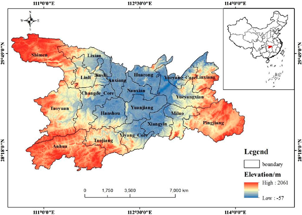
Figure 1. Spatial location of Dongting Lake and its topographic features.
Data utilized for the present study were obtained from a remote sensing map of the Sentinel-2 satellite of the area of Dongting Lake captured in 1990, 1995, 2000, 2005, 2010, 2015, and 2020. The data were interpreted using ENVI’ supervised classification, and the interpretation accuracy met the requirements. These images provided valuable information on the various land use types present in the Dongting Lake region, including forest land, arable land, grassland, wetland, open water (OW) area, building land, and unused land.
Furthermore, data on grain prices, sown area, and agricultural production statistics were obtained from the Hunan Statistical Yearbook published by Hunan Province and various annual statistical yearbooks of cities, counties, and districts in the province. These sources provided essential data related to agricultural activities and production within the area of study.
The transfer matrix is a quantitative tool used to describe LULCC within a specific area over a defined time period (Wang et al., 2017). It offers valuable insights into the structure of land use types, the extent of land use type transitions, and the direction of change (Zhang et al., 2018). In this study, we utilized the collected land use type data and used ArcGIS to overlay the land use/cover type fields from the two periods, namely, before and after the period of study. By calculating the area of each patch class in the newly generated layer, we obtained the transfer area matrix or transfer probability matrix of LULCC. This matrix facilitated the analysis of the overall process and the dynamic characteristics of LULCC in the area of Dongting Lake from 1990 to 2020 (Hu et al., 2020).
To calculate the ESV, we used the total system equivalent (TSE) upland equivalent factor method (Xie et al., 2015). This method involves determining the ratio between the national grain unit area production and adjusting it based on the corresponding value equivalents of vegetation cover and land cover conditions (Han et al., 2020; Wang et al., 2023), estimating the average grain yield from 1990 to 2020, obtaining the ESV coefficient of land use types in the Dongting Lake area, and calculating the total ESV of the region based on the area of the land use types and the ESV per unit area. It is important to highlight that the calculation process excluded construction land, as it typically exhibits limited ecosystem services and extremely low, or even negative, ESV (Wang et al., 2022).
To quantify the gain or loss of the ESV resulting from the transfer between different types of land, we utilized specific conversion data for each land use type (Yan et al., 2014; Liu et al., 2018). By considering these factors, we were able to assess the changes in the ESV resulting from land use transformations, thereby providing a comprehensive understanding of the impacts of LULCC on ecosystem services in the area of study. In this study, sensitivity coefficients (CS) were used to verify the robustness of the ESV results (Zhai and Li, 2022). By calculation, the sensitivity indices for the six land use types in the study area were all less than 1, with a maximum of 0.823 for forest land and a minimum of 0.658 for unused land, which indicated that the results of estimating the ESV results were valid.
The Mann–Kendall change-point test is (Eqs 1–3) a statistical method used to identify systematic transitions from one state to another (Lei et al., 2019). When the M-K method is used to detect trend mutations, the statistic is set to the time series x1, x2, x3, … … xn, and an order column mi is constructed, with mi denoting the cumulative number of samples for xi > xj(1 ≤ j ≤ i). dk is defined as
The average and variance in dk are defined as
Assuming random independence of time series, the statistic is specified as
UFk represents a series that follows a standard normal distribution. Given a significance level of ɑ0, we can refer to the normal distribution (Table 1) to obtain the critical value t0. If UFk > t0, it suggests a significant trend of either increase or decrease in the series. All values of UFk together form a curve C1, which can be tested for trend using a confidence test.
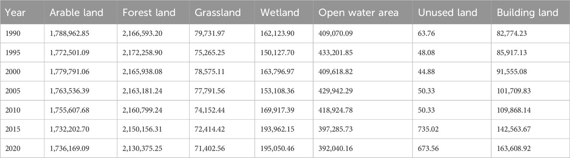
Table 1. Status of land use types in the area of Dongting Lake from 1990 to 2020 (hm2).
Applying the same method to the inverse series, we repeat the above calculation process and multiply the calculated value by −1 to obtain UBk. UBk is represented on the graph as curve C2. If curve C1 exceeds the confidence line, it indicates the presence of a clear trend. If the intersection of curves C1 and C2 lies between the confidence lines, this point may represent the beginning of a mutation point (Qin et al., 2005; Lei et al., 2019).
In the present study, the M-K mutation test was primarily utilized to identify trend mutation points during the period of study and analyze LULCC and ecosystem services from 1990 to 2020.
To evaluate the influence of LULCC on ESV, this study employed a combination of gray relational analysis and path analysis. Gray relational analysis is a statistical method used to quantify the influence of factors within a system by comparing their ensemble relationships (Li et al., 2023). It ranked the correlation degrees to evaluate the influence of shifts in land use types on ecosystem services. The computational steps are determining the analytic series, dimensionless quantization of the series, calculating the correlation coefficient, calculating the degree of association, and ranking the degree of association. On the other hand, path analysis examined the degree of influence between independent variables and their direct and indirect effects on dependent variables (Kang et al., 2015; Li et al., 2023). It determined the relative importance of land use area sizes on the ESV and explored the effects of scale composition on ecosystem services. By integrating these methods, the present study provided a comprehensive examination of the impact of LULCC on the ESV, considering both the scale and transfer of LULCC.
In the path analysis, the total ESV was treated as the dependent variable, while the area of land use types served as the independent variable. The direct and indirect effects of the size composition of diverse land use types on changes in ecosystem services were analyzed by solving the path coefficients. Figure 2 represents the variable settings and initial model, with arrows indicating cause–effect relationships. The direction of the arrow represents the “effect,” and the starting point of the arrow signifies the “cause.”
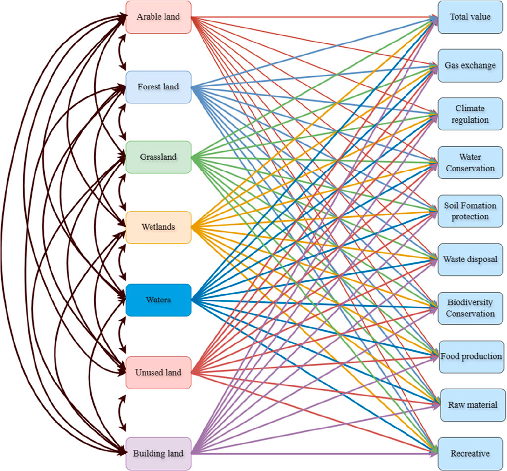
Figure 2. Map of the pathways between land use and ecosystem services.
The analysis of land use type data for the area of Dongting Lake from 1990 to 2020 (see Table 1) reveals that the main land use types are forest land and arable land, collectively accounting for over 82% of the area. In 2020, forest land and arable land accounted for 82.45%, the lowest proportion during the period, while in 1990, they accounted for the highest proportion at 84.35%. Forest land alone accounts for over 45.4% of the total land use type. Notably, the proportion of building land grew considerably during the period of study, rising from 1.8% in 1990 to 3.5% in 2020.
To analyze the transfer of land use types, the land use type maps from 1990 to 2020 were statistically superimposed, resulting in the creation of land use conversion Sankey diagrams for different periods (Figure 3). The diagrams illustrate the shifts in land use types during specific time intervals. From 1990 to 1995, there was a substantial transfer between arable land and open water area. The period from 1995 to 2000 primarily involved transfers between open water area and wetland. The years 2000–2005 and 2005–2010 witnessed frequent transfers between arable land, open water area, and building land. Wetland, open water area, and arable land were the primary types undergoing transfers from 2010 to 2015, while the years 2015–2020 experienced significant transfers of arable land and building land. The main reasons for the large-scale transfer of land use types in the Dongting Lake area are the implementation of ecological restoration projects for returning farmland to forests and grasslands, comprehensive rocky desertification control, and the development of urbanization, which have resulted in a large area of unsuitable land for returning farmland to forests and grasslands and the encroachment of lands such as mountainous dry land, meadows, and paddy fields.
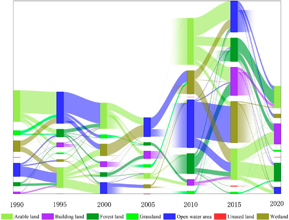
Figure 3. Sankey map illustrating the area transfers of major land use types for six periods from 1990 to 2020.
To further investigate the internal transfers among land use types in the Dongting Lake region, the land use data of 1990, 1995, 2000, 2005, 2010, 2015, and 2020 were examined using the spatial analysis tool in ArcGIS. The overlay of land use data generated land use transition maps for the seven periods (Figure 4), allowing for the spatial analysis of land use transitions. Although the area proportion of each land type transformed into another is relatively small, the transfers occur frequently, and there are complex transformation relationships between open water area, wetland, and other land types.
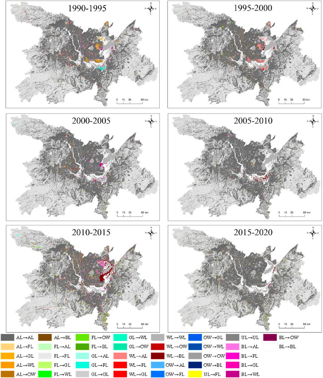
Figure 4. Spatial distribution of LULCC in the area of Dongting Lake from 1990 to 2020.
Based on the findings presented in Figure 5, it is evident that the ESV in the area of Dongting Lake showed a volatile trend over the years 1990, 1995, 2000, 2005, 2010, 2015, and 2020. Initially, there was a growth in value, followed by a subsequent reduction, and, finally, another increase. Among the various ecosystem service types, their relative proportions remained relatively stable from year to year. Food production consistently had the lowest share, ranging from 2.29% to 2.37% throughout the period of study. On the other hand, open water area consistently had the highest share, ranging from 21.2% to 21.47%. Regarding the contribution of various land use types to the overall ecosystem, forest land made the highest contribution, ranging from 52.22% to 53.04% during the period of study, followed by open water area, wetland, arable land, grassland, and unused land (refer to Figure 6).
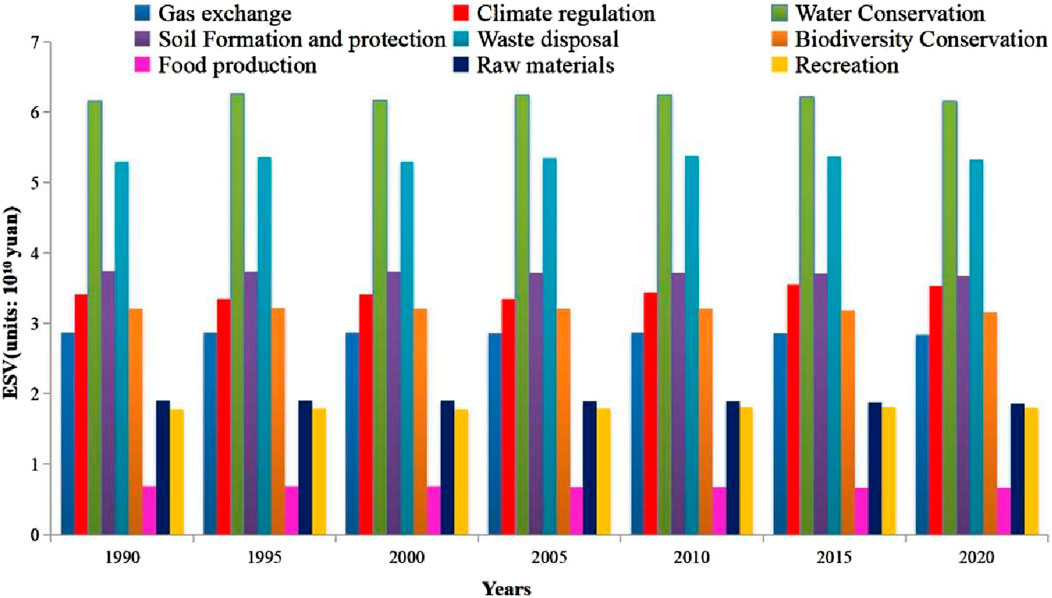
Figure 5. Value of individual ecosystem services from 1990 to 2020.
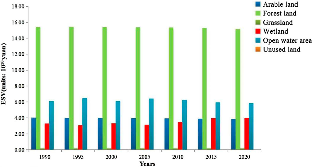
Figure 6. ESV of different land use types in the area of Dongting Lake, 1990–2020.
The changes in the ESV of various land use types and the values of different ecosystem service types are depicted in Figures 7, 8, respectively. Based on Figure 7, the ESVs of arable land and grassland exhibit negative growth, except for the period 1995–2000. Similarly, forest land shows negative growth, except for 1990–1995. Open water area displays negative growth, except for 1990–1995 and 2000–2005, while wetland demonstrates positive growth, except for 1990–1995 and 2000–2005. Regarding the composition of the ecosystem service types shown in Figure 8, notable changes in growth and decline are observed in climate regulation, water conservation, and waste disposal. When examining the trend of increase and decrease in the ESV, the proportions of positive and negative increases are evenly distributed. Specifically, apart from raw materials, which consistently exhibited a “decreasing” trend, all other types displayed an “increasing–decreasing” fluctuation trend during the six time periods of the study, with no distinct pattern. Additionally, some variations exist among the different types.
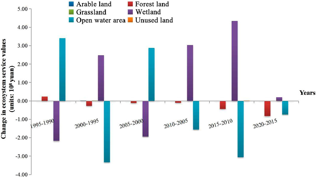
Figure 7. Changes in ecosystem service values of different land types in the area of Dongting Lake, 1990–2020.
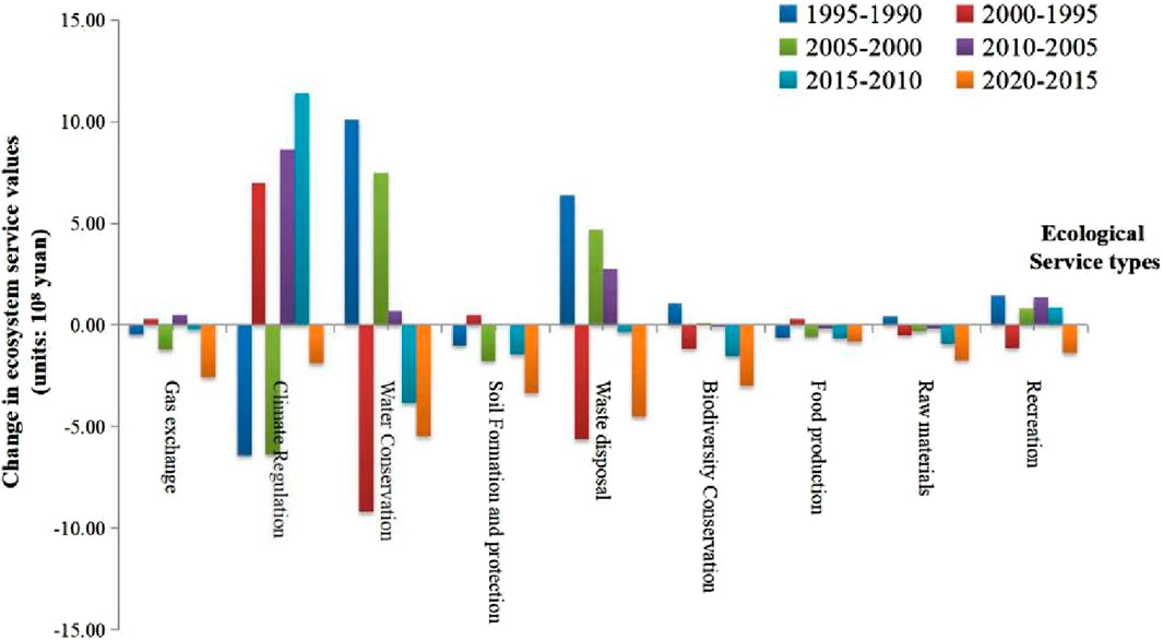
Figure 8. Changes in ecosystem service values from 1990 to 2020.
A spatially differentiated map illustrating the changes in ecosystem service gains and losses for the six periods between 1990 and 2020 was generated (Figure 9). The map highlights that the changes in ecosystem service gains and losses are predominantly influenced by changes in land use types.

Figure 9. Changes in ecosystem service value over six periods from 1990 to 2020.
Regarding the total ESV, more counties exhibited positive growth than negative growth during the early part of the period of study. However, by late 2005, a greater number of counties experienced negative growth.
Analyzing the trends of positive and negative growth for individual ecosystem service types, significant changes were observed in Li County, Huarong County, and Yueyang County from 1990 to 1995. From 1995 to 2000, Li County exhibited substantial changes and notable differences compared to the other counties in Changde District. The overall trend remained moderate from 2000 to 2005 and 2005 to 2010. However, from 2010 to 2015 and 2015 to 2020, a larger number of counties within the region displayed significant changes.
To provide a clearer analysis of the trend changes in land use types, a study on the mutation of land use types and ecosystem services was conducted for the period 1990–2020 using the M–K method. The findings are shown in Figures 10, 11. Figure 10 illustrates the M-K trend curves (UF and UB) for forest land, arable land, building land, wetland, grassland, unused land, and open water area. The intersection points of these curves indicate the presence of mutation points in the scale series. Specifically, arable land, forest land, and building land exhibited a mutation point in 2005, while grassland, wetland, and unused land showed a mutation point in 2010, and open water area only displayed a mutation point in 2015. The results of the M–K mutation analysis of the ecosystem services are shown in Figure 11. Significant mutation points were observed for each ecosystem service. Notably, soil formation and conservation, as well as waste disposal, exhibited multiple mutation points. Analyzing the mutation trend, the types of gas exchange, soil formation and conservation, biodiversity conservation, food production, and raw materials demonstrated a significant decrease after the mutation year. Conversely, climate regulation and recreation and leisure showed an increasing trend following the mutation year. The findings from the M–K mutation analysis revealed a strong correlation between mutation points of land use and ecosystem services. The analysis indicated that mutation points were predominantly observed around 2005. However, it is important to note that the spatial variability of changes in land use contributes to distinct spatial characteristics in the changes of the affected ESV.

Figure 10. Analysis of abrupt change points in land use type change from 1990 to 2020.
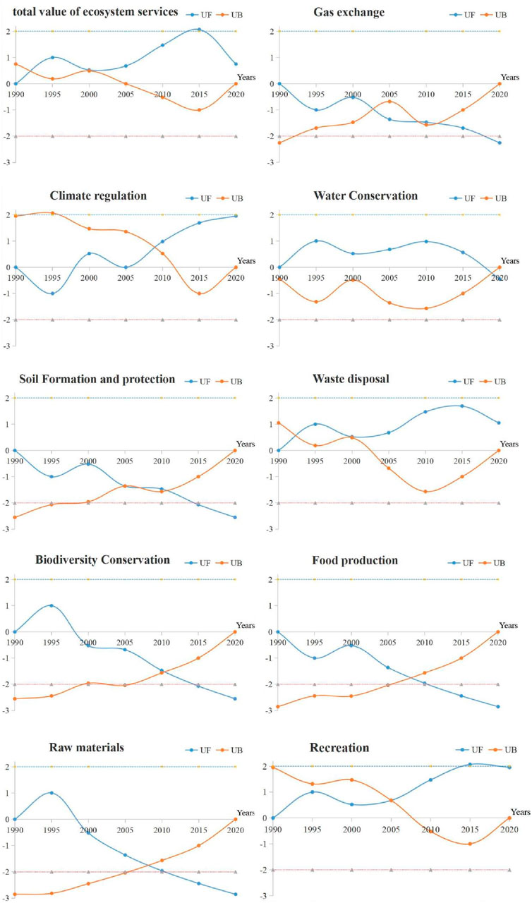
Figure 11. Analysis of abrupt change points in ecosystem service changes from 1990 to 2020.
The composition and scale of land use types not only directly impact the ESV but also indirectly influence changes in service value through interactions. To understand the importance and influence of direct and indirect influences of land use types on the ESV, the direct and indirect path coefficients of the overall ESV and the area of land use types were calculated, and the consequences are presented in Table 2. As provided in Table 2, the largest direct effect on the total effect of ecosystem services is on forest land, with a direct coefficient of 0.567, while the indirect effects are on wetland, grassland, arable land, unused land, and open water area. The results indicate that the impact of LULCC on the ESV is not solely determined by the scale of land area but rather by the combined effect of interactions between different land use types. For the impact of land use types on the value of individual ecosystem services, Figure 12 reveals important insights. Forest land has a greater direct impact on each of the ecosystem services in the order of conservation of biodiversity, gas exchange, climate regulation, soil formation and conservation, climate regulation, and recreation and leisure, while forest land has an indirect impact on these ecosystem services through other land use types. Water conservation is mainly affected by wetland and forest lands, with direct path coefficients of 0.53 and 0.38 and total indirect path coefficients of 0.34 and 0.35, respectively. In terms of food production, the land use types with the highest direct and total indirect path coefficients vary. For waste disposal, wetland exhibits the largest direct and indirect coefficients, with values of 0.54 and 0.35, respectively.
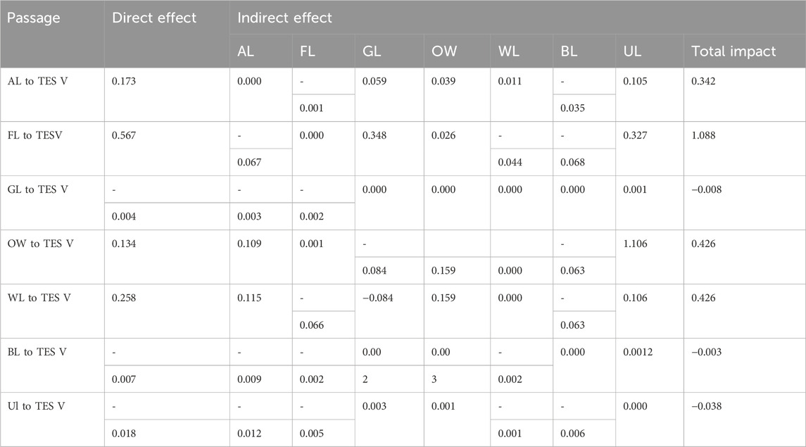
Table 2. Passage analysis of land use type on the total value of ecosystem services (TESV).
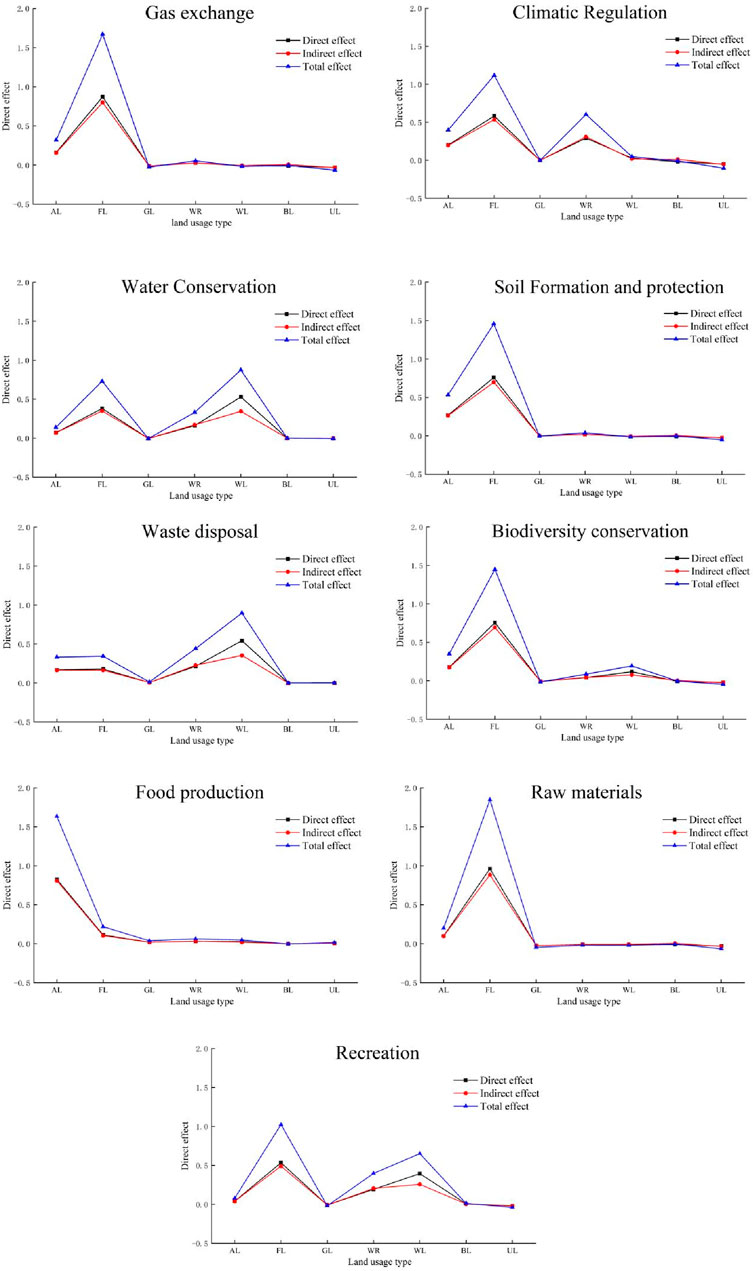
Figure 12. Passage coefficients of land use and value of individual ecosystem services.
It should be noted that unused land has negative direct and indirect coefficients for ecosystem services. Overall, the indirect coefficients for all ecosystem service types are primarily positive or negative. When the sum of the two coefficients is greater than 0, it suggests that land use can overcome negative effects and promote positive effects, thereby maximizing the ESV. The determination coefficients and decision coefficients for each land use factor on ecosystem services were calculated using the direct and indirect path coefficients. The raw material type exhibited the lowest determination coefficient (R2) of 0.991, indicating the high reliability of the data and findings in this study, as evidenced by the determination coefficient and residual path coefficient (Yin et al., 2018). The p-value was 0.000, showing a statistically significant difference between ecosystem services and the influence of land use. The decision coefficients are shown in Figure 13.
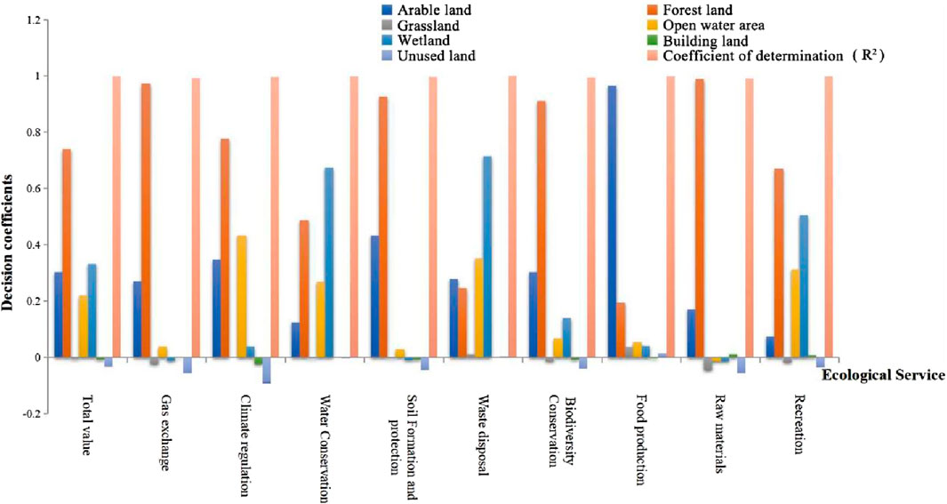
Figure 13. Decision coefficients for land use and ecosystem services.
Figure 13 indicates that the decision coefficients for the total ESV are ranked as follows: forest land, wetland, arable land, open water area, building land, grassland, and unused land. Forest land, wetland, arable land, and open water area have positive decision coefficients, indicating that they make significant contributions to the total ESV, with forest land being the top influencing variable. Conversely, unused land and building land have negative decision coefficients, suggesting that they have limiting effects on the total ESV. Regarding individual ecosystem service types, FL and AL rank the highest for gas exchange and raw materials. FL and OW have the highest decision coefficients for climate regulation. WL and FL dominate in water conservation. WL and OW are key factors for soil formation and conservation, food production, and biodiversity conservation. WL and FL show significant influence on recreation and leisure. These rankings illustrate the varying influencing factors for each ecosystem service type.
To assess the influence of land use quantity changes on the ESV, the factors influencing land use quantity change were defined, as provided in Table 1. The gray correlation model was used to analyze the factors influencing changes in land use area for ecosystem services. This analysis determined the correlation between each factor and ecosystem service, ranked the correlation of each factor, and assessed the strength of the correlation for each factor (Figure 14).
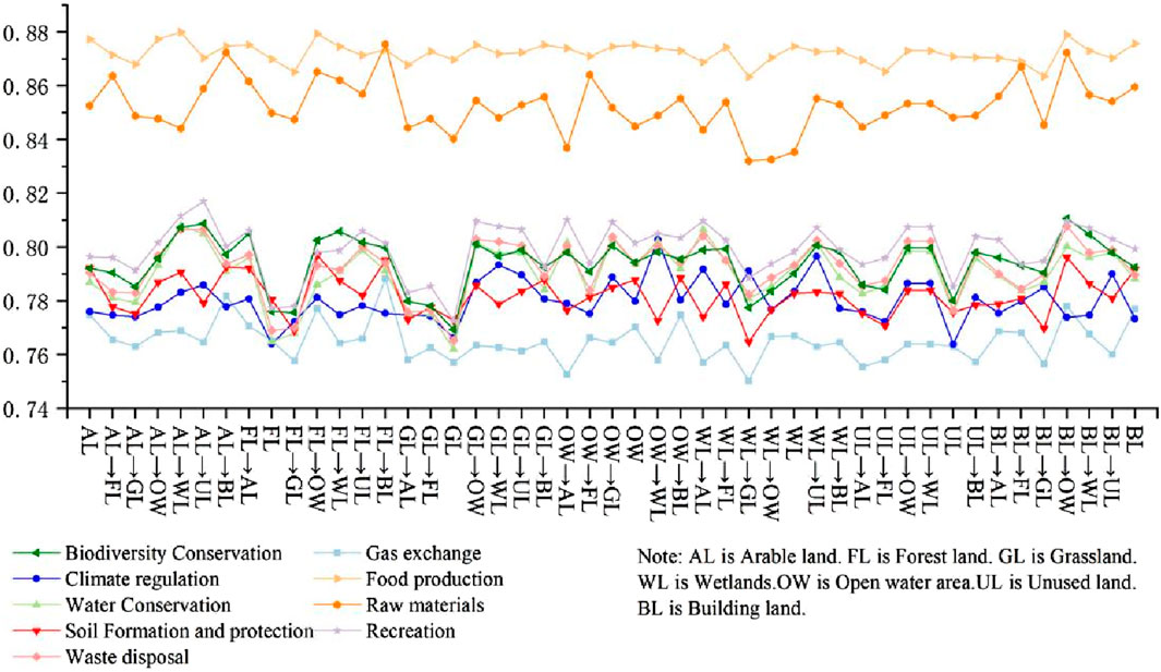
Figure 14. Correlation coefficients of LULCC factors for different ecosystem service types.
Figure 14 reveals the correlation coefficients of LULCC factors for different ecosystem service types. The top 10 correlations influencing the ESV are as follows: arable land–unused land, open water area–building land, building land–open water area, building land–wetland, unused land–open water area, unused land–wetland, forest land–building land, forest land–unused land, wetland–building land, and arable land–building land. Examining the top 10 correlations for individual ecosystem service types, open water area–building land, arable land–building land, and building land–open water area are the most frequent changes in land use factors. These factors, specifically open water area–building land and building land–open water area, exhibit strong associations with gas exchange, water conservation, soil formation and conservation, waste disposal, conservation of biodiversity, food production, and recreation and leisure. The arable land–building land factor shows strong associations with climate regulation, water conservation, waste treatment, biodiversity conservation, food production, and recreation. Other factors with weaker influence not appearing in the top 10 rankings include arable land–grassland, forest land–forest land, forest land–grassland, grassland–arable land, grassland–forest land, grassland–grassland, wetland–forest land, wetland–open water area, wetland–wetland, arable land–wetland, grassland–open water area, unused land–forest land, and unused land–grassland.
The outcomes of the current study provide important insights into the relationship between LULCC and ecosystem services in the area of Dongting Lake. The analysis revealed several key findings that contribute to our understanding of the association between land use and ecosystem services in the region.
The changes in the ESV of different land use types and the values of different ecosystem service types are depicted in Figures 7, 8, respectively. Based on Figure 7, the ESVs of arable land and grassland exhibit negative growth, except for the period 1995–2000. Similarly, forest land shows negative growth, except for 1990–1995. Open water area displays negative growth, except for 1990–1995 and 2000–2005, while wetland demonstrates positive growth, except for 1990–1995 and 2000–2005. Compared with the results of Zeng et al. (2022), the spatial correlation between land use intensity and ecosystem services in the Dongting Lake area is consistent with the findings of the present study. Regarding the composition of ecosystem service types shown in Figure 8, notable changes in growth and decline are observed in climate regulation, water conservation, and waste disposal. When examining the trend of increase and decrease in the ESV, the proportions of positive and negative increases are evenly distributed. Specifically, apart from raw materials, which consistently exhibited a “decreasing” trend, all other types displayed an “increasing–decreasing” fluctuation trend during the six time periods of the study, with no distinct pattern. Additionally, some variations exist among the different types.
Changes in land use types have a considerable effect on the provision of ecosystem services, with certain land use types playing a more prominent role than others. First, the dominant land use types in the area of Dongting Lake are arable land and forest land, which account for a significant proportion of the overall land area. This finding highlights the importance of agricultural activities and forest ecosystems in the region. The increase in construction land and wetland areas during the period of study indicates a decrease in the extent of arable land and forest land. The main factors driving these land use type transitions in the area of Dongting Lake include the return of fields to the lake, the implementation of ecological restoration projects, and urbanization development. However, it is concerning to note the significant increase in building land over the period of study. This suggests ongoing urbanization and infrastructure development, which can have adverse effects on ecosystem services and biodiversity, reflecting the serious damage to ecosystems caused by land use degradation due to anthropogenic pressures (Rashid et al., 2023). The results of the study are important for land use planning and ecosystem management in the area of Dongting Lake. They underscore the need for sustainable land use practices that prioritize the preservation and restoration of forest ecosystems, wetland, and arable land to ensure the provision of essential ecosystem services. Additionally, the findings highlight the importance of considering the spatial and temporal dynamics of LULCC and their impacts on ecosystem services when formulating land use policies and management strategies.
This analysis shows that LULCC is a complex interaction of various factors, and there are strong differences. Since the contribution of ecological land types, such as forest land and open water area, to ecosystem services differs significantly from that of non-ecological land types, the impact of conversion between ecological land types on ecosystem service changes is generally not significant, indicating that the characteristics of land use type conversion are dominated by ecological land and non-ecological land conversion. The analysis of the direct and indirect effects of land use types on the ESV revealed that forest land has the largest direct effect, indicating its critical role in supporting ecosystem services. Grassland and unused land were found to have significant indirect effects, highlighting the importance of considering their interactions with other land use types. The results also emphasized the complex interactions between different land use types in influencing ecosystem services, suggesting that the scale and composition of land use types are both essential factors to consider in land use planning and management.
Socio-humanitarian influences were not taken into account in this study, and there are a great number of interactions between various factors, as well as the synergistic complexity of the trade-offs that exist in the ecosystem services themselves, so it is difficult to determine a comprehensive causal relationship between them, and the study also has some limitations. It is necessary to further improve the assessment methodology, increase the precision of data collection and analysis, comprehensively consider the impacts of socio-economic factors and other factors on LULCC and ecosystem services, and explore the coupling mechanism between the trade-offs of different ecosystem services and the optimization of land use so that the overall impacts of LULCC can be assessed in a more comprehensive way and more effective management strategies can be found.
In this study, we conducted an analysis of LULCC and the dynamics of ecosystem services in the area of Dongting Lake from 1990 to 2020. The results provide valuable insights into the relationship between land use and ecosystem services, with important implications for land use planning and ecosystem management in the region. Our analysis revealed significant changes in land use types, with arable land and forest land dominating the land use types. The proportion of building land increased over the period of study, reflecting ongoing urbanization and infrastructure development. These changes in land use types have implications for the provision of ecosystem services in the region. The temporal patterns of ecosystem service changes showed fluctuations in the value of ecosystem services over time. While the relative proportions of different ecosystem service types remained relatively stable, the contribution of different land use types to overall ecosystem services varied. Forest land emerged as a key contributor to ecosystem services, emphasizing the importance of preserving and managing forest ecosystems. The spatial analysis highlighted the divergent characteristics of ecosystem changes across the Dongting Lake region. The changes in ecosystem service gains and losses were predominantly influenced by changes in land use types. This underscores the need for targeted land use planning and management strategies to ensure the sustainable provision of ecosystem services and maintain the ecological integrity of the region. Furthermore, influencing factors such as land use structure and scale have direct and indirect effects on ecosystem services. The implications of this study for land use planning and ecosystem management are substantial.
The findings underscore the need for sustainable land use practices that prioritize the preservation and restoration of forest ecosystems, wetland, and arable land. In conclusion, this study contributes valuable insights into the dynamics of land use and ecosystem services in the area of Dongting Lake. The spatial and temporal differentiation of LULCC and ecosystem services is explored, the integrated effects of land use shifts on ecosystem services are accurately assessed, and the impact mechanisms of land use and ecosystem services are revealed from the perspective of factor interactions, which are able to better capture the holistic and integrated effects of land use shifts on ecosystem services. The findings contribute to our understanding of the complex interactions between LULCC, climate change, and ecosystem services, providing a basis for sustainable land management and environmental decision making in the region. The results highlight the importance of balancing development and environmental conservation to ensure the long-term wellbeing of both human communities and the ecosystem in the area of Dongting Lake. Additionally, considering the spatial and temporal dynamics of changes in land use and their impacts on ecosystem services is crucial in formulating effective land use policies and management strategies for land use planning and ecosystem management.
The raw data supporting the conclusion of this article will be made available by the authors, without undue reservation.
ZC: conceptualization and writing–original draft. YL: software and writing–review and editing. DC: conceptualization, funding acquisition, methodology, and writing–review and editing. BP: methodology, project administration, resources, and writing–review and editing.
The author(s) declare that financial support was received for the research, authorship, and/or publication of this article. This research was funded by the National Natural Science Foundation of China (42271229 and 42171213) and the Natural Science Foundation of Hunan Province, China (2024JJ8037 and 2021JJ30471).
The authors declare that the research was conducted in the absence of any commercial or financial relationships that could be construed as a potential conflict of interest.
All claims expressed in this article are solely those of the authors and do not necessarily represent those of their affiliated organizations, or those of the publisher, the editors, and the reviewers. Any product that may be evaluated in this article, or claim that may be made by its manufacturer, is not guaranteed or endorsed by the publisher.
Aimaitikali·Wumaieraili (2021). “The coordination relationship between land use change and ecological service value change —case study in ili river VallE(y) in xinjiang,” (Wuhan: China University of Geosciences). Ph.D. thesis.
Bai, Y. J., Li, X. D., and Liu, X. L. (2017). Impact of land use change on the ecosystem service value based on path analysis-A case study in Xifeng District, Qingyang City. J. Gansu Agric. Univ. 52 (6), 120–126. doi:10.13432/j.cnki.jgsau.2017.06.02
Dar, S. A., Bhat, S. U., Aneaus, S., and Rashid, I. (2020). A geospatial approach for limnological characterization of Nigeen Lake, Kashmir Himalaya. Environ. Monit. Assess. 192, 121–218. doi:10.1007/s10661-020-8091-y
Dar, S. A., and Dar, J. A. (2024). Linking carbon storage with land use dynamics in a coastal Ramsar wetland. Sci. Total Environ. 932, 173078. doi:10.1016/j.scitotenv.2024.173078
Esfandeh, S., Danehkar, A., Salmanmahiny, A., Sadeghi, S. M. M., and Marcu, M. V. (2021). Climate change risk of urban growth and land use/land cover conversion: an in-depth review of the recent research in Iran. Sustainability 14 (1), 338. doi:10.3390/SU14010338
Fu, B. J., and Zhang, L. W. (2014). Land-use change and ecosystem services: concepts,methods and progress. Prog. Geogr. 33 (4), 441–446. doi:10.11820/dlkxjz.2014.04.001
Gascoigne, W. R., Hoag, D., Koontz, L., Tangen, T. A., and Shaffer, T. L. (2011). Valuing ecosystem and economic across land-use scenarios in the prairie pothole region of the dakotas, USA. Ecol. Econ. 70 (10), 1715–1772. doi:10.1016/j.ecolecon.2011.04.010
Guo, C. Y., Gao, S., Zhou, B. Y., and Gao, J. H. (2019). Effects of land use change on ecosystem service value in Funiu Mountain based upon a grid square. Acta Ecol. Sin. 39 (10), 3482–3493. doi:10.5846/stxb201803210558
Guo, X. Y., Liu, X. L., and Wang, L. G. (2016). Study on land use optimization in order to improve ecosystem service: a case of Lanzhou City. Acta Ecol. Sin. 36 (2), 1–10. doi:10.5846/stxb201505070942
Han, Z. L., Meng, Q. Q., Yan, X. L., and Zhao, W. Z. (2020). Spatial and temporal relationships between land use intensity and the value of Ecosystem Services in northern Liaodong Bay over the past 30 years. Acta Ecol. Sin. 40 (8), 2555–2566. (in Chinese). doi:10.5846/stxb201903120471
He, G. L., Li, J. L., Liu, Y. C., Shi, X. L., Ma, J. W., Pu, R. L., et al. (2019). Spatio-temporal analysis of land development and utilization intensity in Tampa Bay waters from 1985 to 2015. J. Nat. Resour. 34 (01), 6679. doi:10.31497/zrzyxb.20190106
Hu, C., Zhang, L., Wu, Q., Soomro, S. e. h., and Jian, S. (2020). Response of LUCC on runoff generation process in middle yellow River Basin: the gushanchuan basin. Water 12 (5), 1237. doi:10.3390/w12051237
Islam, K. R., Kamaluddin, M., Bhuiyan, M. K., and Badruddin, A. (2015). Comparative performance of exotic and indigenous forest species for tropical semievergreen degraded forest land reforestation in Chittagong, Bangladesh. Land Degrad. Dev. 10 (3), 241–249. doi:10.1002/(sici)1099-145x(199905/06)10:3<241::aid-ldr335>3.3.co;2-#
Kang, Y. X., Qi, G. P., Wang, J. H., Yin, C. C., Ma, Y. L., and Ga, U. (2015). Research on distribution characteristics and influencing factors of reference crop evapotraspiration in Gansu Province. J. Gansu Agric. Univ. 50 (5), 120–127. doi:10.13432/j.cnki.jgsau.2015.05.020
Kassun, B. W., Maarit, I., K, A., Trømborg, E., and Mekonen, R. M. (2024). Vegetation density and altitude determine the supply of dry Afromontane forest ecosystem services: evidence from Ethiopia. For. Ecol. Manag. 552, 121561. doi:10.1016/J.FORECO.2023.121561
Lei, J. C., Wang, S., Wang, J. M., Wu, S. Q., You, X. B., and Wu, J. (2019). Effects of land use change on ecosystem services value of Xunwu County. Acta Ecol. Sin. 39 (09), 3089–3099. doi:10.5846/stxb201802010280
Li, W., Li, H., Yan, Z., Hu, B., Zhu, Y., Yang, Y., et al. (2023). Regeneration patterns and drivers of different underutilized lands in the rust belt city of developing country:An empirical case study for Northeast China. J. Geogr. Sci. 33 (07), 1377–1396. doi:10.1007/s11442-023-2134-6
Li, Y. C., Li, Z. X., Zhang, X. P., Yang, A., Gui, J., and Xue, J. (2023). Spatial and temporal changes in vegetation cover and response to human activities in Qilian Mountain National Park. Acta Ecol. Sin. 43 (1), 219–233. (in Chinese). doi:10.5846/stxb202107221990
Li, Y. F., Zhan, J. Y., Liu, Y., Zhang, F., and Zhang, M. (2018). Response of ecosystem services to land use and cover change: a case study in Chengdu City. Resour. Conservation Recycl. 132 (5), 291–300. doi:10.1016/j.resconrec.2017.03.009
Liu, W., Zhan, J. Y., Zhao, F., Yan, H., Zhang, F., and Wei, X. (2019). Impacts of urbanization-induced land-use changes on ecosystem services: a case study of the Pearl River Delta Metropolitan Region, China. Ecol. Indic. 98 (3), 228–238. doi:10.1016/j.ecolind.2018.10.054
Liu, Y. R., Wang, C., and Yan, L. J. (2018). Impacts of land use change on ecosystem services in the agricultural area of North China Plain: a case study of Shangqiu City, Henan Province, China. Chin. J. Appl. Ecol. 29 (5), 1597–1606. doi:10.13287/j.1001-9332.201805.011
Liu, Z. T., Wang, S. J., and Fang, C. L. (2023). Spatiotemporal evolution and influencing mechanism of ecosystem service value in the Guangdong-Hong Kong-Macao Greater Bay Area. J. Geogr. Sci. 33 (06), 1226–1244. doi:10.1007/S11442-023-2127-5
Mengistie, K., Thomas, S., Martin, D., Teketay, D., and Knoke, T. (2018). Scenario modelling of land use/land cover changes in Munessa-Shashemene landscape of the Ethiopian highlands. Sci. Total Environ. 622-623 (1), 534–546. doi:10.1016/j.scitotenv.2017.11.338
Munthali, M., Mustak, S., Adeola, A., Botai, J., Singh, S., and Davis, N. (2020). Modelling land use and land cover dynamics of Dedza district of Malawi using hybrid Cellular Automata and Markov model. Remote Sens. Appl. Soc. Environ. 17, 100276. doi:10.1016/j.rsase.2019.100276
Niu, F. Q., and Jiang, Y. P. (2021). Economic sustainability of China's growth from the perspective of its resource and environmental supply system: national scale modeling and policy analysis. J. Geogr. Sci. 31 (08), 1171–1186. doi:10.1007/s11442-021-1891-3
Panwar, A. S., Ansari, M. A., Ravisankar, N., Babu, S., Prusty, A. K., Ghasal, P. C., et al. (2022). Effect of organic farming on the restoration of soil quality, ecosystem services, and productivity in rice–wheat agro-ecosystems. Front. Environ. Sci. 10. doi:10.3389/FENVS.2022.972394
Qin, N. X., Jiang, T., and Xu, C. Y. (2005). Trends and abruption analysis on the discharge in the Yangtze Basin. Resour. Environ. Yangtze Basin 05, 589–594.
Radford, K. G., and James, P. (2013). Changes in the value of ecosystem services along a rural-urban gradient: a case study of Greater Manchester, UK. Landsc. Urban Plan. 109 (1), 117–127. doi:10.1016/j.landurbplan.2012.10.007
Rashid, I., Aneaus, S., Dar, S. A., Javed, O., Khanday, S. A., and Bhat, S. U. (2023). A novel GIS-based multicriteria analysis approach for ascertaining the catchment-scale degradation of a Himalayan wetland. Environ. Res. 229, 115967. doi:10.1016/j.envres.2023.115967
Rashid, I., Dar, S. A., and Bhat, S. U. (2022). Modelling the hydrological response to urban land-use changes in three Wetland catchments of the Western Himalayan region. Wetlands 42 (7), 64. doi:10.1007/s13157-022-01593-z
Santos-Martin, F., Zorrilla-Miras, P., Palomo, I., Montes, C., Benayas, J., and Maes, J. (2019). Protecting nature is necessary but not sufficient for conserving ecosystem services: a comprehensive assessment along a gradient of land-use intensity in Spain. Ecosyst. Serv. 35, 43–51. doi:10.1016/j.ecoser.2018.11.006
Shang, S. W., Cui, T. T., Wang, Y. T., Gao, Q., and Liu, Y. (2024). Dynamic variation and driving mechanisms of land use change from 1980 to 2020 in the lower reaches of the Yangtze River, China. Front. Environ. Sci. 11. doi:10.3389/FENVS.2023.1335624
Shi, C. N., Yao, S. B., Chen, X. N., Xue, C. X., and Gong, Z. W. (2016). Economic valuation of ecosystem services based on choice experiments: a case study of wenjiang in sichuan Province. J. Nat. Resour. 31 (05), 767–778. doi:10.11849/zrzyxb.20150334
Wang, F. H., Zhao, R. F., Zhang, L. H., and Li, H. W. (2017). Process of land use transition and its impact on regional ecological quality in the Middle Reaches of Heihe River, China. Chin. J. Appl. Ecol. 28 (12), 4057–4066. doi:10.13287/j.1001-9332.201712.020
Wang, H. B., Wang, W. J., Wang, L., Ma, S., Liu, Z., Zhang, W., et al. (2022). Impacts of future climate and land use/cover changes on water-related ecosystem services in changbai mountains, northeast China. Front. Ecol. Evol. 10. doi:10.3389/FEVO.2022.854497
Wang, Y. F., Liu, H. L., Fu, J., Li, Y. J., Bai, B. Q., and Tian, Q. C. (2023). NDVI characteristics and precipitation sensitivity of urban agglomeration in Central Shanxi Basin. Ecol. Econ. 19 (04), 359–373.
Wang, Y. J., QU, Z. Y., and Zhong, Q. C. (2022). Delimitation of ecological corridors in a highly urbanizing region based on circuit theory and MSPA. Ecol. Indica. 142. doi:10.1016/J.ECOLIND.2022.109258
Xie, G. D., Zhang, C. X., Zhang, L. M., Chen, W. H., and Li, S. M. (2015). Improvement of the evaluation method for ecosystem service value based on per unit area. J. Nat. Resour. 30 (8), 1243–1254. doi:10.11849/zrzyxb.2015.08.001
Yan, E. P., Lin, H., Wang, G. X., and Xia, C. Z. (2014). Analysis of evolution and driving force of ecosystem service values in the Three Gorges Reservoir region during 1990-2011. Acta Ecol. Sin. 34 (20), 5962–5973. doi:10.5846/stxb201312263032
Yang, Y. S. (2015). Study of ecosystem services values based on land use change of Ganzhou District. Res. Soil Water Conservation 22 (5), 163–168. doi:10.13869/j.cnki.rswc.2015.05.030
Yin, D. Y., Zhang, Q. J., and Zhai, T. T. (2018). Land use change and its impact on ecosystem service value in Shandong Province. Bull. Soil Water Conservation 38 (5), 134–143. doi:10.13961/j.cnki.stbctb.2018.05.022
Zeng, Z. W., Yang, H., Ning, Q. M., and Tang, H. (2022). Temporal and spatial evolution of land use intensity and its impact on ecosystem services in Dongting Lake zone. Econ. Geogr. 42 (9), 176–184. doi:10.15957/j.cnki.jjdl.2022.09.020
Zhai, Y. C., and Li, W. (2022). Evaluation and change analysis of ecosystem service value of China's northeast tiger-leopard national park based on big data land use change. Comput. Intell. Neurosci. 2022, 6270731–6270737. doi:10.1155/2022/6270731
Keywords: land use and land cover change, ecosystem service, influence relationship, spatio-temporal analysis, transfer matrix, Dongting Lake
Citation: Chen Z, Liu Y, Chen D and Peng B (2024) Exploring the impacts of land use and land cover change on ecosystem services in Dongting Lake, China: a spatial and temporal analysis. Front. Environ. Sci. 12:1395557. doi: 10.3389/fenvs.2024.1395557
Received: 04 March 2024; Accepted: 29 May 2024;
Published: 17 June 2024.
Edited by:
Salvador García-Ayllón Veintimilla, Polytechnic University of Cartagena, SpainReviewed by:
Muhammad Mainuddin Patwary, Environment and Sustainability Research Initiative, BangladeshCopyright © 2024 Chen, Liu, Chen and Peng. This is an open-access article distributed under the terms of the Creative Commons Attribution License (CC BY). The use, distribution or reproduction in other forums is permitted, provided the original author(s) and the copyright owner(s) are credited and that the original publication in this journal is cited, in accordance with accepted academic practice. No use, distribution or reproduction is permitted which does not comply with these terms.
*Correspondence: Duanlv Chen, ZHVhbmx1Y2hlbkAxMjYuY29t
†These authors have contributed equally to this work and share first authorship
Disclaimer: All claims expressed in this article are solely those of the authors and do not necessarily represent those of their affiliated organizations, or those of the publisher, the editors and the reviewers. Any product that may be evaluated in this article or claim that may be made by its manufacturer is not guaranteed or endorsed by the publisher.
Research integrity at Frontiers
Learn more about the work of our research integrity team to safeguard the quality of each article we publish.