 Karen Wilke
 Andrew Rust
 Darrick Weissenfluh
 Brandon Iddings
 Shane Wulf
- 1The Nature Conservancy, Des Moines, IA, United States
- 2United States Fish and Wildlife Service-Partners for Fish and Wildlife Program, Titonka, IA, United States
- 3Iowa Soybean Association, Ankeny, IA, United States
- 4Iowa Department of Agriculture and Land Stewardship, Des Moines, IA, United States
Oxbows, once an abundant and natural feature of the landscape, have been nearly eliminated due to the effects of the Anthropocene, consequently impacting water quality, flood storage capacity, and the wildlife that depend on this habitat. These depressional basins within floodplains naturally accumulate sediment over time, but the sedimentation rate of oxbows over the last 100 years has greatly increased. The primary sources of sediment are from human activity, including erosion from agricultural fields and urban developments, drainage alterations, precipitation changes associated with climate change, and disconnection from their rivers and natural river hydraulics. Outlined in this manuscript is a step-by-step guide for restoring oxbows, based on 20 years of experience and lessons learned implementing oxbow restorations in Iowa on first-, second-, and third-order streams. Our goal is to provide conservation services providers and others interested in restoring degraded oxbows with the tools and expertise to confidently restore oxbows to achieve conservation goals.
1 Introduction
Rivers are dynamic landscape features that change course over time, naturally and as a result of human influences, resulting in river meanders that become cut-off from the stream channel (Wohlman and Leopold, 1957). These isolated river meanders, known as ‘oxbows’, are an abundant and common characteristic of the landscape. For example, in Iowa it is estimated there are approximately 40,000 acres of river oxbows and overflow wetlands associated with Iowa streams (IAN, 2001).
Oxbow formation and sedimentation are believed to have accelerated since European settlement due to human activity such as runoff from agricultural fields, drainage alterations (e.g., channelization, dredging, and tiling), and development activities (e.g., building and maintaining roads and infrastructure) (Gell et al., 2009). These anthropogenic processes result in further channel incision and are the primary drivers of increased sediment loads, lowered water tables, loss of floodplain storage, and the subsequent degradation of oxbows. As sediment (also known as post-settlement alluvium) has eroded from the landscape since European settlement and has been deposited into oxbows, oxbow hydrology has been altered, floodwater retention has decreased, water quality in river systems and the Gulf of Mexico has decreased, and fish and wildlife habitat has become degraded (Gleason and Euliss, 1998). For the purpose of this article, an oxbow is considered degraded when the habitat is no longer suitable for or capable of supporting aquatic species. Even when sediment deposition is not the primary threat to the health of an oxbow, many oxbows become impaired from being disconnected from their river or from an over-abundance of trees (Fuller et al., 2015).
The human-driven forces present today not only result in the increased creation and sedimentation of oxbows, but also cause oxbow restorations to be less resilient to the many threats that influence Anthropocene rivers and floodplains. As a result of past, present, and future human activities, there is a high likelihood that current river systems will never return to their historic natural state. Conservation service providers (CSPs) involved in oxbow restoration projects should identify current and future threats, and consider using and adapting the methods described in this manuscript to design and construct oxbow restorations that help achieve conservation goals at the local site scale, and at the watershed scale.
Oxbows are natural sediment collection basins within river floodplains, but healthy, functioning oxbows provide essential wildlife habitat and the ability to improve water quality (Simpson et al., 2019; Schilling et al., 2019). Oxbows naturally and continually fill in with sediment from runoff and stream erosion over time. This causes the oxbow to evolve from the main river channel, to a flowing side channel, to an oxbow slough, to an oxbow lake, to upland, but it may return to being the main stream channel at any stage of the cycle (Kondolf, 2011) (Figure 1).
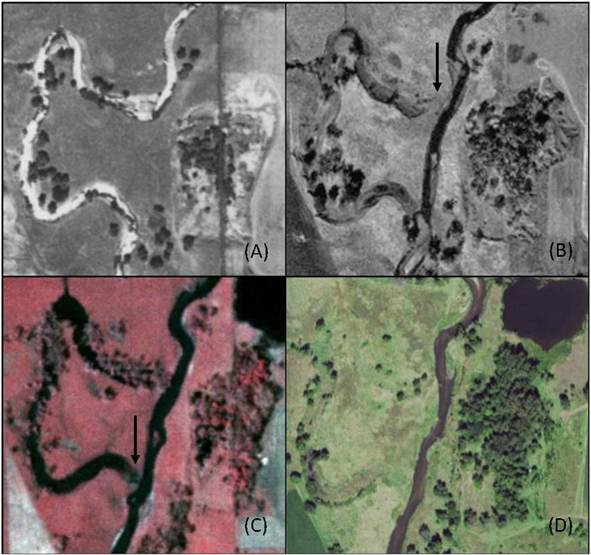
Figure 1. These aerial images of a creek show the formation of an oxbow in Iowa, and the stages of formation as described in Kondolf 2011. (A) 1930s—the main channel of a Creek, (B) 1950s—upstream end plugs with sediment forming an Oxbow Slough, (C) 1980s CIR—downstream end also plugs with sediment forming an Oxbow Lake, (D) 2015—oxbow lake fills with sediment and transitions to Upland (Note: a site assessment needs to be conducted to verify the vegetation is completely or predominantly Upland, the oxbows current hydrology, and the amount of accumulated sediment).
Because degraded oxbows are highly prevalent in the landscape, there is great opportunity for restoration to achieve environmental goals. In particular, specific goals addressed by restorations outlined in this paper are improving the loss of fish and wildlife habitat for endangered species like Topeka Shiner (Notropis topeka) while also providing the opportunity to improve water quality. In Iowa, there are numerous sources of funding for restored oxbows, many CSP who implement the practice, and plenty of farmers and landowners interested in enhancing the conservation value of their land. However, an important consideration is that many oxbows, even those partially filled with sediment, are still providing critical wetland functions naturally, so not every oxbow needs to be restored. Instead, the decision to restore an oxbow should be based upon an assessment of multiple factors including its current stage of formation, natural resource concerns, specific restoration goals, and logistical feasibility.
It is important to recognize that the oxbow formation process naturally consists of sediment erosion and deposition and that restoration does not change that natural process; however, recommendations are provided in the design section to ensure the longevity of the restoration. Though stream re-meandering is a natural process and a useful conservation practice, it is out of the scope of this manuscript. The purpose of the oxbow restoration practice discussed in this manuscript is to maximize the longevity and environmental benefits provided by a restored oxbow that is adjacent but isolated from the main stream during base flow. Stream restoration with the purpose of re-meandering an oxbow is a separate conservation practice that requires additional planning, a more vigorous permitting process, and increased costs compared to oxbow restoration. In Iowa, stream re-meandering is often incompatible with landowner goals, and therefore less likely to be adapted as a conservation practice.
The content of this paper is adapted from the Oxbow Restoration Toolkit (The Nature Conservancy, 2021), a step-by-step guide to restoring oxbows in Iowa, which has been utilized by many different organizations. Although the content was developed for Iowa, there are oxbows in every state and country, so oxbow restoration as a conservation practice may be implement in states across the United States, and globally. The purpose of this article is to provide CSPs with the tools, resources, and knowledge needed to complete an oxbow restoration from start to finish, and to increase the implementation of oxbow restorations as a multi-purpose practice (Figure 2). Oxbow restorations completed in the Boone River Watershed formed the basis for this article and the examples given.
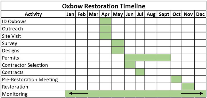
Figure 2. An example of an oxbow restoration timeline. Time to complete restorations can greatly vary by location, weather, and complexity.
2 Methods: the oxbow restoration process
2.1 Identification, mapping, and prioritization
Identifying potential oxbow restoration sites is the first step in the restoration process. A full understanding of the oxbow formation process is necessary to correctly identify them on the landscape, either while analyzing aerial imagery or while visiting a site.
An effective method to identify and map oxbows and prospective oxbow restoration sites is to compare current and historic aerial imagery maps (e.g., 1930s—present) to locate areas where the river has changed or has meandered and been cut off (Figure 3). A combination of aerial imagery, LIDAR, and flood risk maps are useful for identifying an ecological reference in the same watershed (preferred) or region. However, due to the current altered state of many floodplains, it can be difficult to identify quality reference sites. In this case, it may be necessary to develop a conceptual design or model for the oxbow restoration based on a modern landscape context, the desired function, and specific goals. Those same tools can also be used to identify specific impairment(s) or natural resource concerns, the oxbow’s current formation stage, and the likelihood of the oxbow changing stages for any reason in the foreseeable future (e.g., oxbows on the outside bend of a river). These details should then be more closely evaluated during the site visit.
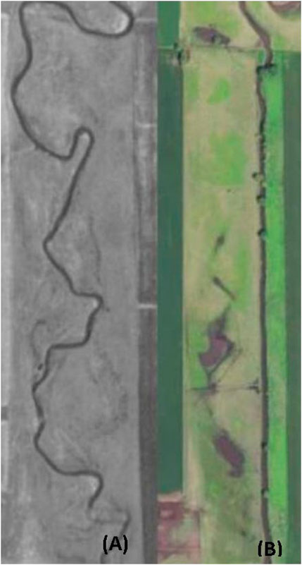
Figure 3. Aerial imagery of the same Iowa stream reach from the 1930s (A) and 2021 (B). Note that the stream was straightened between the 1930’s and 2021.
Aerial maps, however, may not show oxbows that were formed prior to available aerial imagery. In this case, utilizing GIS layers such as the national wetlands inventory, lidar, and/or 2′ contours provides the ability to search for depressions along stream corridors and their floodplains that may not be visible from aerial imagery; however, these maps may overlook oxbows that are entirely filled with sediment and are in the upland stage. As a best practice, it is recommended to use a combination of spatial data (e.g., aerial, LiDAR, and contour layers) to search for and identify oxbows. A mapping tool created by Iowa State University, called the Agriculture Conservation Planning Framework (ACPF) may also be used for modeling data if a watershed is supported by the ACPF. The ACPF tool uses high resolution geospatial data layers to identify site-specific opportunities to install conservation practices, such as oxbow restorations, across small watersheds. The tool does have limitations and is only available in select states, therefore using multiple methods to identify potential sites is recommended. Once a potential oxbow site is identified, map editing tools should be used to save the location of the oxbow, ensuring it can be viewed later in the planning process.
There are several key variables to consider when prioritizing which oxbows to pursue for restoration. At the watershed scale, it is important to determine if other agencies and partners have identified oxbow restoration as a priority conservation practice and, if so, to know if and how much funding is available. It is also crucial to understand the characteristics of each specific watershed that the oxbows are located in, including water resource issues and any specific threatened species, endangered species, or species of greatest conservation need that would benefit from these restorations. For example, the Boone River watershed in north central Iowa has prioritized oxbow restorations as a conservation practice to restore habitat for Topeka Shiner. Topeka Shiner, a federally endangered 3-inch-long minnow that lives and breeds in low-order prairie streams of the Great Plains states, occurs in the Boone River watershed and relies on healthy oxbow habitat. The alteration of the Boone River watershed, and other prairie stream watersheds within the Topeka Shiner range, has resulted in habitat degradation, followed by significant population declines (U.S. Fish and Wildlife Service, 2023).
On a site-specific scale, an important factor to consider is whether an oxbow restoration in that particular stream reach will help achieve specific landowner goals or contribute to larger landscape goals. For instance, restoring an oxbow in a specific stream reach may be important for achieving conservation goals for a specific species of fish, because other reaches of the stream do not have suitable habitat or have barriers that prevent dispersal. Additionally, spatial data or different map layers in ArcGIS may be useful to determine if a particular oxbow restoration will be too costly or logistically challenging to restore because of access issues, heavy forestation, or a lack of spoil placement locations nearby.
As potential oxbow restoration sites are assessed, any information or comments about each site should be documented, which will be useful during the prioritization process. If using ArcGIS, adding fields to an attribute table with labels such as “Landowner Name and Address,” “Conservation Goals,” and “Comments” is recommended to track critical information associated with each site. After a thorough analysis of the site from an aerial perspective using a relevant set of imagery, landowner outreach is the next step to gather potential interest and schedule a site visit to confirm the findings.
2.2 Landowner outreach
Landowner outreach is essential for cultivating landowner interest in restoring degraded oxbows. Many landowners will likely not know what an oxbow is, whether they have an oxbow on their property, or the restoration potential of the site.
A first step when reaching out to a prospective landowner is to send an introductory letter containing information about what an oxbow is, the location of the potential restoration site, the benefits that an oxbow provides, cost-share opportunities, and contact information for the CSP. Adding personalization to the letter by handwriting the names and addresses on the envelope may reduce the likelihood of the letter being thrown away immediately as junk mail. Since letters are often thrown away or forgotten, following up with a phone call a few weeks after sending the letter will establish if the landowner received the letter, is interested in more information, or is disinterested in the practice. If the landowner is interested, the CSP should seek to schedule a meeting at the restoration site or in an office setting to further discuss the restoration opportunity.
There are several effective outreach approaches for raising awareness of oxbow restorations. Messaging should focus on the multiple benefits that restored oxbows can provide for water quality, floodwater storage, wildlife habitat, livestock, scenery, and the conservation value of the land. For landowners with potential restoration sites on their land, field days are a powerful tool that can connect the landowners to CSPs and to local advocate landowners that have completed oxbow restorations on their property. Landowners with past oxbow restorations on their property may be useful contact points for reaching and building trust with neighbors who have potential restoration sites on their property. General public outreach opportunities may include presenting at meetings or conferences, creating and sharing educational brochures, writing newspaper articles, posting on websites and social media, and sharing resources with partner organizations who can help promote the practice. Partner organizations may include ag retailers, local extension and outreach offices, and state and federal government agencies.
2.3 Site visit
When a landowner of a potential oxbow restoration has expressed interest in learning more about the potential restoration, the next step is for the landowner and CSP to visit the site together. The individual(s) who has(have) authority to make decisions about the land should be present at the site visit. This is not always the landowner if another person has power of attorney or if tenants are involved. If multiple landowners are listed on the deed, permission will need to be granted from all interested parties.
The purpose of the site visit is to gather more detailed information about the property, oxbow, stream, and landowner. This includes verification of impairment(s) or natural resource concerns, the oxbow’s current formation stage, and the likelihood of the oxbow changing stages for any reason in the foreseeable future. Information gathered will help determine if a project is feasible and will meet the objectives of the landowner, address resource concerns, fulfill funding source requirements, and determine which permits may be required. Site visits also provide information for components of the survey and design. Multiple visits may be required to collect all the necessary information.
Site visits are also an opportunity to learn about the landowner’s long-term goals for and concerns with their property (Engaging Landowners, 2024). Example goals may include bird viewing, hunting, fishing, and/or improving the land for future generations. Ensuring that the restoration aligns with the landowner’s goals will help ensure the long-term protection of the oxbow. During this meeting, elements of the restoration project should be discussed with the landowner, tenant, and other stakeholders, to ensure that the restoration will fulfill the goals of all the stakeholders and address specific resource concerns.
Prior to the site visit, it is recommended to prepare maps to help understand the site, including a general site map that contains an overview of where the oxbow fits within the adjacent landscape. Other elements to include in the maps are property boundaries, potential heavy equipment access points and routes, and potential spoil placement sites. Additional spatial data that can be included are satellite imagery, floodplain boundaries, elevation data with LiDAR or contour maps, national wetland inventory boundaries, tile and drainage infrastructure, and soil data. These maps help identify the exact location of the oxbow when present at the site, especially when the oxbow location may be difficult to find because the oxbow is completely filled with sediment or is located in dense tree cover.
While at the site, the current function of the oxbow should be assessed. Factors to be discussed with the landowner may include the oxbow’s current capacity to retain water, the duration of water retention, and the presence of wildlife and native plants. Unless the oxbow is in the upland stage of formation, it is likely providing habitat for some wetland-dependent species of fish, wildlife, and/or plant. In this case, restoration may not be necessary or may have a negative impact on some species. Therefore, additional monitoring and assessment of oxbow hydrology may be needed to evaluate the current status of the oxbow.
Oxbow hydrology is unique in that it is greatly influenced by both fluvial processes (e.g., sediment erosion and deposition) and climatic conditions (e.g., drought and flooding). Consequently, oxbow hydrology often exhibits seasonal, annual, and decadal variation. For instance, an oxbow partially or unevenly filled with sediment may have surface water continuously for multiple years during average or above average precipitation, but the same oxbow may go dry for multiple months during drought conditions. Therefore, an assessment of the hydrological inputs and outputs, such as surface flow, tile drainage, groundwater, and stream connection can be useful in understanding how the oxbow will function hydraulically and hydrologically. For instance, if the stream is very disconnected from the oxbow via a levee or deeply incised streambanks, a channel connecting the oxbow to the stream may need to be created or enhanced to optimize hydrology and achieve specific goals (e.g., fish movement in and out of the oxbow).
The current and future land use plans should be discussed to better understand how an oxbow restoration will fit in with the landowner’s operations and to ensure the longevity of the restoration. For instance, it may be short-sighted to restore an oxbow if the landowner intends to convert the area to crop production as a result of high crop prices. The site visit and landowner conversation should also include an inventory of other conservation programs the land is currently enrolled in. Certain conservation practices can be beneficial when paired with oxbow restorations, such as planting cover crops in an adjacent farm field or planting a buffer strip to prevent erosion into the oxbow. Conversely, oxbow restorations may not be compatible with some conservation programs or certain funding sources.
A suitable location for the excavated spoil should also be identified during the site visit. Typically, in Iowa, fertile black topsoil is removed from the oxbow, which can be appealing for increasing the productivity of an adjacent farm field. In one case, a landowner reported an increase of 20 bushels per acre after spreading oxbow spoil in his farm field (K. Law, personal communication, 12 July 2023). It is recommended to place the excavated spoil on previously disturbed ground such as a crop field (but not in hydric soils and not on remnant prairie where the sod has never been broken) and outside of the regulatory floodplain to reduce the likelihood of the spoil eroding into the restored oxbow or the stream. However, it may be possible to spread the spoil within the floodplain if there are no other cost-effective options for spoil placement and the floodplain permit regulations for the area allow for spoil placement in the floodplain.
The desired size of restoration should also be discussed, and is influenced by the goals, adjacent land use, and historic size of the oxbow when it was formed. For example, if floodwater storage is the goal, then maximizing the depth and extent of the restoration may be most beneficial.
Restoration sites previously or currently located adjacent to a farm field may present an opportunity to maximize water quality and storage benefits through the interception of subsurface tile and drainage infrastructure. If available, maps identifying drainage infrastructure should be brought to the site visit and discussed. If this data is not available, the site visit is an opportunity to work with the landowner to scout for and identify any potential tile outlets that may be intercepted by the oxbow. It is important to check if routing tile into an oxbow is allowed by the funding source used and to consider how tile drainage into an oxbow may affect the function (e.g., hydrology) and other abiotic factors (e.g., water temperature, nutrients, etc.).
The presence of sensitive areas or sensitive plant and animal species should be taken into consideration in the restoration plan. Sensitive areas may include but are not limited to steep slopes (which often contain remnant prairie because the sod has never been broken), livestock areas, crop areas, grassed waterways, tile outlets, remnant prairie locations, and habitat for threatened species, endangered species, or species of greatest conservation need. For streams with unstable meanders, other restoration or stabilization techniques may need to be considered to reduce the likelihood of re-meandering the stream when restoring an oxbow.
Tree presence is another major site factor that should be analyzed prior to and during the site visit. Information collected relating to trees should include the different tree species present within the site, the number of trees that will need to be removed during restoration, and landowner input on any trees they want to keep. Trees that are cleared should be removed from the floodplain, burned, or incorporated into the project to create habitat (e.g., large woody debris installation to provide habitat for amphibians, fish, and birds). Trees within and around an oxbow can be a major barrier to heavy equipment access. The removal of such trees can be a time consuming and expensive addition to restoration costs. A more cost-effective alternative to complete tree removal is to girdle trees that do not need to be removed for heavy equipment access purposes.
2.4 Funding
Relevant funding opportunities are critical to identify early on when planning an oxbow restoration project, because costs can vary greatly by contractor, geography, and design elements. Assessing all potential sources of funding, including which funds can be paired together, will help to decide which funding source is best in each project situation. It is also pertinent to identify which funding source will be utilized early in the process, because each funding source will have its own set of requirements and standards to follow throughout the restoration process. For instance, funding sources may have guidelines or requirements on how a survey should be conducted, exactly what elements need to be included in the designs, or which permits are needed.
In Iowa, there are many state, federal, and private programs that provide funding for oxbow restorations (The Nature Conservancy, 2021). Program eligibility can vary by geography, area resource concerns such as priority species and habitats, or presence of other watershed projects. In deciding which funding source is best, it is helpful to determine the project goals, evaluate the resource concerns, determine program eligibility, and receive landowner, tenant, or other stakeholder input in the decision. In many cases, it is possible to leverage multiple funding sources for a single project, but program eligibility should be verified with the lead agency for each funding source before pairing.
2.5 Elevation survey
The purpose of the survey is to collect precise elevation data at the project site to accurately assess an oxbow’s current function and to create a technically and biologically-sound design. Elevation data are also essential to calculate accurate quantities of spoil to be removed and the volume of the oxbow pool, which are important components of the design and permits. A survey form and map should be created prior to the survey to identify required data to be collected, in order to maximize the efficiency of the on-site survey and ensure important elevation data are captured. A template is provided to guide the basic content that should be collected during a survey in the Supplementary material section.
During the survey, cross-sectional elevations should be captured at each substantial change in topography or at least every 100 feet along the length of the oxbow. Adjacent stream elevations should be taken near the downstream connection of the oxbow, and should include water elevation, stream bed elevation at the thalweg, stream top width and bottom width, and a cross-section of the existing stream channel. It is also important to take elevations of any infrastructure that could impact the oxbow, such as nearby drainage tiles, culverts, roads, or berms. Since the water level in the restored oxbow will be defined by the downstream hydraulic control (e.g., stream riffle and beaver dam), the upstream oxbow plug, and the downstream oxbow plug, a stream survey will help identify the stream riffle that will establish the minimum water level in the excavated oxbow and will provide the proper oxbow dimensions as formed by the stream (Figure 4).
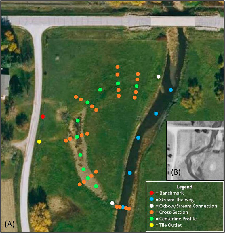
Figure 4. An example of pre-restoration survey (elevation) locations to be used inthe assessment and design processes. Image (A) is aerial imagery from 2023 and (B) is the same stream reach from the 1930s.
The elevation of the spoil placement is important, especially in regard to its proximity to the floodplain. Finally, multiple soil cores within the oxbow can help to verify the depth of the historic stream bed (i.e., depth to dig) and likely spoil composition.
Two common methods for surveying the elevation of an oxbow are point surveys or continuous topographic surveys. A survey is usually completed using a survey-transit (e.g., grade rod and laser), total station (e.g., Trimble S6), or survey-grade GPS equipment (e.g., Trimble R12); the choice may be influenced by equipment availability, site topography, and tree canopy cover. Semi-permanent or temporary benchmarks should be established and marked prior to implementing the site survey for future reference and evaluation of site conditions post-construction. Existing survey and design standards should be followed (as applicable) prior to conducting a site survey (The Nature Conservancy, 2021). It may be helpful to upload a preliminary design sketch from GIS into a GPS device to help identify the oxbow boundary while in the field.
It is also helpful to establish permanent photo points during the initial site survey. Photos are useful to reference when creating the design and can also be included with permitting documents and reporting requirements, as well as pre- and post- monitoring efforts.
2.6 Design
The design of an oxbow restoration should correspond to the primary goals of the project and result in habitat that is similar to intact oxbow habitat or an ecological reference site within the same watershed. The landowner and other stakeholders should determine the most important goals for the restoration and state the goals as specifically as possible in the designs. Some possible examples of general goals may include improved water quality, improved wildlife habitat (e.g., improving roosting and foraging habitat for waterfowl during spring and fall migration), or increased floodwater storage. When possible, goals should be specific and measurable, such as improving water quality by reducing nitrate-nitrogen by >40%, restoring the hydrology and hydroperiod of the oxbow to provide suitable habitat for Topeka Shiner and other fish, or increasing floodwater storage by 50%. It is also important to consider the historic, current, and future oxbow habitat function, condition, and land-use, as viewed as a continuum of change. Prior communications with the landowner, and observations during the site visit and survey will all help inform the design.
The complexity of an oxbow restoration design will vary by site and depend on the goals of the project (Figure 5). Best practice recommendations are as follows (The Nature Conservancy, 2021):
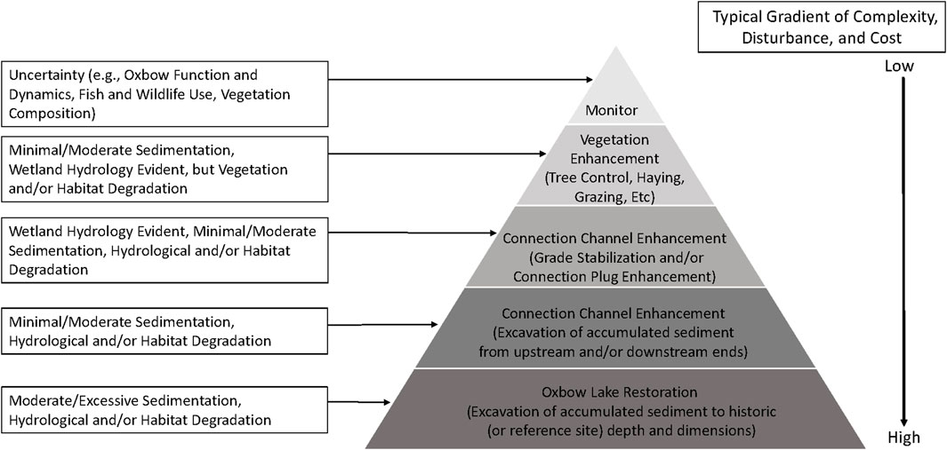
Figure 5. A variety of oxbow restoration and enhancement activities can be implemented based on natural resource concerns, specific goals, and comparison with an ecological reference oxbow. Complexity, disturbance, and cost will vary by activity. If a conservation professional is unsure about an oxbows current function and/or wildlife use, additional monitoring (e.g., game cameras, multiple site visits throughout the seasons, and seining) is recommended.
Water depth within an oxbow can affect water quality and the fish community (Goetz et al., 2015; Carlson Mazur et al., 2022), and the hydroperiod can affect amphibian assemblages (Henning and Sherato, 2006) and plant communities (Penfound, 1953). Therefore, creating bathymetric diversity and uneven bottoms will have a substantial impact on the oxbow habitat and hydroperiod. These design elements should be considered based on the goals for vegetation community and structure, and fish and wildlife habitat. In most cases, the historic stream thalweg elevation should be exposed during restoration and can be determined by a soil investigation and through survey elevation data from the current adjacent stream (Figure 6). Similarly, the width and length of the oxbow should follow the historic shape and size of the oxbow, or a reference site, based on historic aerial photos and on-the-ground site investigations. Restored bank width may need to be wider than historic bank width to account for more gentle slopes, incised streams, and/or project goals.
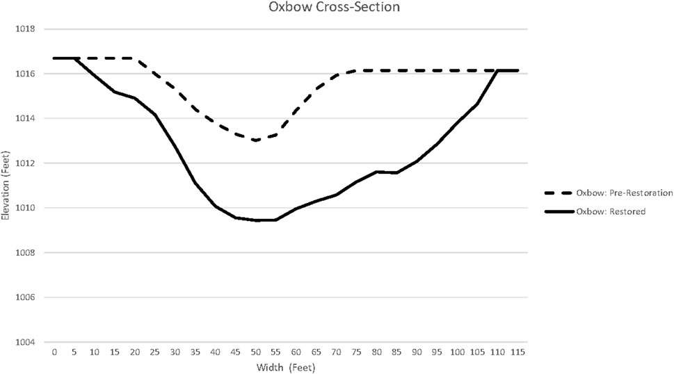
Figure 6. A cross-section of an oxbow before- and after-restoration in Iowa. Prior to restoration, the oxbow was primarily in the “Upland” stage based on vegetation, hydrology, and the amount of accumulated sediment, but the oxbow did still hold a relatively small amount of water after precipitation and flood events in some areas with less sediment deposition. Note that the resource concerns were excessive sedimentation and fish habitat degradation. The conservation goals of the project were to restore the oxbow to the “Oxbow Lake” stage by removing accumulated sediment (Post-Settlement Alluvium) to specifically benefit Topeka shiner (and other fish and wildlife), and to increase floodwater storage, extend the oxbow hydroperiod (the restored oxbow holds more water from precipitation events and was reconnected to the groundwater), and improve water quality due to the increased water residence time of surface runoff into the oxbow. The “Oxbow-Restored” dimensions are based on a conceptual model using the dimensions of the main channel adjacent to the oxbow because we could not identify an ecological reference oxbow in the watershed or region that had the desired function, structure, or dynamics to achieve the conservation goals. The “Oxbow-Restored” depth was based on a soil investigation and is the same as the historic thalweg elevation.
A simple way to estimate the volume of sediment that will need to be removed from the oxbow when the inside and outside slopes are the same elevation is to use the trapezoidal prism formula:
(((top width + bottom width)/2) × depth) × length = cubic feet to be excavated
It is helpful to determine how active the floodplain is, how frequently the oxbow may connect with the stream, and if a connection channel needs to be created or modified to accomplish the oxbow restoration goals (Figure 7). Connectivity is an important factor affecting the fish community (Fischer et al., 2018). If a natural connection exists between the stream and the oxbow on the downstream end of the oxbow, the connection channel may be sufficient. As an example, if the oxbow is located within Topeka Shiner habitat range, the oxbow should connect with the stream annually or biennially to facilitate dispersal during bank-full stage (or greater) flood events. Flood frequency can be gleaned from personal or landowner knowledge of flood history and from flood risk maps. In some states (e.g., Iowa), landowners and CSPs can also request base flood elevations from regulatory agencies. Modifying an existing channel or creating a new connection channel at the upstream end of the oxbow could result in the stream re-meandering. Therefore, additional design considerations (e.g., grade-stabilization or inlet/outlet structures) may be needed if the upstream end of the oxbow will be restored or enhanced.
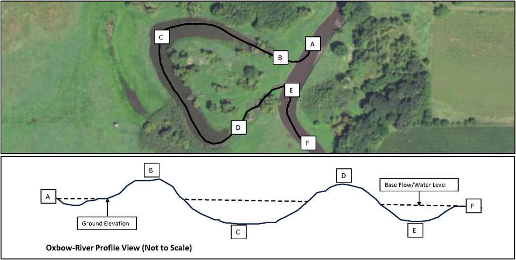
Figure 7. When the adjacent stream (A, E, F) is at base flow, the water level in an oxbow (C) will be similar and is determined by the hydraulic control in the creek that is downstream of the oxbow (F), which is often a riffle or beaver dam. An oxbows maximum water level (Full Pool) that can be maintained is determined by the elevation of the upstream plug (B) and downstream plug (D). The hydraulic control elevations (F, D, B) will also determine the frequency an oxbow will connect with the adjacent stream; a higher (F) elevation and/or lower (D) and/or (B) elevations will result in increased oxbow-stream surface water connections whereas a lower (F) elevation and/or higher (D) and (B) elevations will result in decreased oxbow-stream surface water connections. If it’s desirable to increase the oxbow-stream connection frequency, an oxbow-stream connection channel is typically created on the downstream end of the oxbow (between (D, E)).
To maximize water quality and quantity benefits, it is possible to intercept subsurface tile into restored oxbows if doing so is compatible with project goals and funding sources. However, further research on the impacts of tile or outputs from other conservation practices (e.g., bioreactors) on aquatic ecosystems is needed.
The design should include seeding after the restoration is completed to benefit wildlife and stabilize the banks of the oxbow. However, exact seed mixes will depend on landowner goals (e.g., pasture mix vs. native seed mix). A quick growing nurse cover crop can be seeded to quickly stabilize the banks and prevent sediment erosion into the oxbow.
When considering tree removal at the site, the restoration goals, resource concerns, equipment access, number of trees to remove, and cost of removal all should be taken into account. Other factors to take into consideration include the site’s historic tree cover, whether anoxic events from decaying leaf litter may negatively affect target aquatic species, and if there are any desirable trees to preserve. Tree girdling is an alternative to tree felling that can also improve the habitat adjacent to the oxbow. Felled trees could be placed in the oxbow as large woody debris to achieve in-water structure or other wildlife habitat goals, such as turtle basking habitat. However, placing woody debris in oxbows makes post-restoration fish sampling more difficult and may require additional design consideration such as the need for anchoring large wood to prevent movement during flood events.
Oxbow restoration designs should, at a minimum, include all elements requested in the floodplain permit application. Examples of information to include in a design are: a plan view of the project area, at least one cross-section showing current and proposed elevations and slopes, a profile or side view showing current and proposed elevations, proposed spoil placement locations, an estimate for the quantity of spoil to be removed, equipment access routes and staging areas, elevations of other relevant features (e.g., tiles, culverts, roads, and berms), connection channel dimensions, tree clearing and pile locations, re-seeding instructions, relevant construction and material specifications, relevant notes, and photos of the current site conditions or a reference site (Figure 8).

Figure 8. An example of an oxbow restoration design from Hamilton County, Iowa.
Whenever possible and appropriate, existing conservation practice standards should be followed. When Natural Resources Conservation Service (NRCS) funding is used for oxbow restoration, design specifications should follow the NRCS Wetland Restoration Conservation Practice Standard (Natural Resources Conservation Service, 2023d). Post-restoration seeding of native species should also be completed in all disturbed areas and spoil areas, following the NRCS Critical Area Planting Conservation Practice Standard (Natural Resources Conservation Service, 2023a). Enhancing seed mixes with plants beneficial to pollinators should be considered when possible. If a channel connecting the oxbow to the river will be constructed and/or tree clearing will be required, the NRCS Grade Stabilization Structure Conservation Practice Standard (Natural Resources Conservation Service, 2023b) and NRCS Land Clearing Conservation Practice Standard (Natural Resources Conservation Service, 2023c) should be followed, respectively. In Iowa, meeting or exceeding NRCS standards can fast-track floodplain permitting. Additional design requirements may need to be followed if threatened or endangered species (e.g., Topeka Shiner or Long-eared bat) occur within the project area (refer to the permitting section).
2.7 Contracts and landowner agreements
Contracts and/or landowner agreements are necessary documents whenever funding and/or technical assistance are provided to implement an oxbow restoration and should clearly articulate expectations, cost-share allocations, and project duration.
Terms of contracts and agreements will vary in scope from agency to agency and are an important topic of discussion early in the conservation planning process. It is imperative that each party involved understands their roles and responsibilities to ensure the oxbow will be a successful conservation project for years to come.
2.8 Permits
A variety of federal, state, and local permits may be required to ensure project activities and effects are documented. Permits minimize negative effects to land, infrastructure, and wildlife, and ensure regulatory requirements are met. In Iowa, construction, excavation or filling in of streams, lakes, wetlands, or floodplain may require permits from both the U.S Army Corps of Engineers and Iowa Department of Natural Resources (Iowa Department of Natural Resources, 2023). Following established practice standards as applicable, establishing agency-specific procedures for permitting, and developing a formal landowner agreement will streamline the permitting process. However, permitting for projects in a floodplain can be complex and permit applications often require multiple levels of governmental review and several months for approval. There are also many different types of permits that correspond to different impacts, such as floodplain construction, threatened and endangered species, and cultural resources. Although it is up to the landowner to ensure all required federal, state, and local permits are obtained, regulatory agencies will provide guidance to help landowners and CSP’s understand and meet applicable rules.
In Iowa, it is most effective and efficient to use the online Permit and Environmental Review Management Tool (PERMT) to determine if floodplain permits may be needed and, if so, to apply for permits by submitting a Joint Application. By submitting a Joint Application using PERMT, the applicant is able to submit project information simultaneously to the USACE for review under Section 404 of the Clean Water Act and to the DNR (U.S. Environmental Protection Agency, 2023). The Oxbow Restoration Toolkit provides a more detailed example of the permitting process in Iowa (The Nature Conservancy, 2021). The permitting process will vary by state and may also vary at the county or local level.
2.9 Contractors
In most cases, a contractor will need to be hired to excavate the oxbow, remove trees, and re-seed any disturbed areas. Typically, a contractor will need to have access to and be able to operate an excavator, dump truck, bulldozer, and other heavy equipment necessary for restoration. They should be licensed and insured, and have experience with land improvement or wetland restoration projects. At key points, the CSP or landowner should be onsite during construction to answer questions that arise and ensure design plans are followed. Depending on the funding source, three or more competitive bids may be needed to ensure a fair price is paid for the project. When possible, the project should be advertised as broadly as possible, making sure to include minority, women, and small local businesses. Knowing the average cost per cubic yard for excavations in the geography of the project will confirm if bids are a reasonable price. Site conditions, geography, and logistics (especially spoil placement distance and tree removal) vary by site and can greatly impact the actual cost of restoration.
Information for the contractor should include restoration designs, oxbow location, estimates of cubic yards to be removed, and the number and size of trees to be removed. Contractors should know that working conditions may be wet and muddy, be aware of the timeline for when work should be completed by (month and year), and understand the seasons and conditions in which work cannot be completed because of impacts to wildlife and landowner preference. Contractors may also need to wait for excavated spoil to dry before final grading.
2.10 Project management
Active project management is important to make sure the project is completed as designed and in a timely manner. Contractors may not be familiar with how to restore oxbows, since it is a relatively new conservation practice. Creating clear and precise guidelines for the contractor, and being onsite when they begin the restoration ensures that all design components and target depths are understood.
Communication is key when it comes to project management, with frequent site visits and phone calls needed. Keeping all parties informed and up to date on the status of the project will create a smooth restoration process. Restoration meetings should be held before, during, and at completion of the project and include project managers, contractors, landowners, tenants, and any other parties involved to ensure that concerns are addressed along the way.
Before restoration begins, and ideally before bidding, the perimeter of the project should be clearly marked for the contractor to see the extent of the excavation. Photo points or game cameras can be used to monitor and track progress (Figure 9).
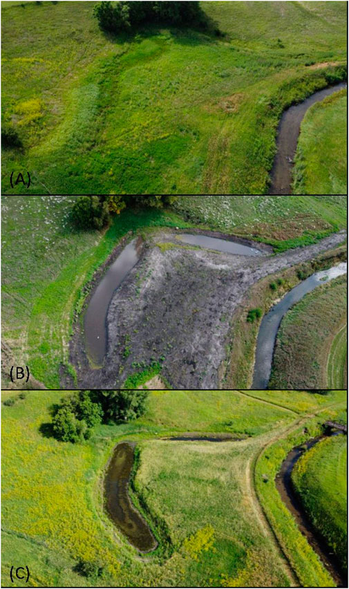
Figure 9. Drone photos of an oxbow before restoration (A), during restoration (B), and after restoration (C).
2.11 Lessons learned and best practices
It is common to learn something new with each restoration due to the uniqueness of each oxbow. Included below is a non-exhaustive list of lessons learned by conservation professionals across Iowa.
⁃ Tradeoffs exist with regard to species or goals. Not every species can benefit from the restoration and not every goal can be met. It is the CSPs job to utilize the best available science and evaluation tools to make decisions that will have the greatest benefits.
⁃ Last minute changes should be expected and taken into consideration in the designs. When they occur, they should be documented in writing. For example, a tenant may verbally agree to spread the stockpiled spoil in the adjacent farm field after restoration but may change their mind when they realize it is more work than planned for. This may result in having to hire another contractor to spread the spoil last minute or to find another spoil placement location. Landowners should be encouraged to only pay for work that has been completed. Any revisions to soil placement locations should be confirmed by the CSP and be consistent with the permit’s terms and conditions, and the landowner’s preferences.
⁃ There is often a very short window for restoring oxbows. Excavated spoil is often placed in an adjacent farm field, resulting in oxbows that can only be excavated between crop harvest and planting. Contractors are often busy with more profitable projects during the fall, and many prefer not to work in the winter because frozen ground is hard on equipment. The project timeframe is also limited by weather conditions; too much snow may make it hard to see the topography and spring floods may leave the site too wet to work in. To the extent possible, a broad timeline (2–3 years) should be planned for to complete the project.
⁃ All required permits should be obtained and understood, including the ‘terms and conditions’ of each permit. In the case of an unexpected situation arising during restoration, a primary contact should be identified. (e.g., a potential cultural resource is unearthed during excavation).
⁃ The progress of the restoration should be monitored frequently to ensure that design specifications and standards are being met. Oxbow restoration is a fairly new conservation practice, and for many contractors, it may be their first time on a restoration project. There have been cases of contractors digging in the wrong spot, not digging deep enough, and digging too deep.
⁃ A back-up plan should exist for the excavated spoil, or the landowner should sign an agreement on spoil placement. There have been cases where a local contractor agreed to haul the dirt off site in order to utilize at a later time, but backed out after restoration already began. The contractor should be specific with spoil placement locations and any revisions to these locations will need to be consistent with all permit terms and conditions. Additionally, a backup plan should be in place for where to place excavated soil that contains more sand or rocks than anticipated. Landowners and tenants will likely not want soil that is too sandy, rocky, or has substantial woody debris to be spread in their farm field.
⁃ If quicksand is unearthed during excavation, it may be best to stop restoration in that specific area and try to dig other areas of the oxbow.
⁃ Taking one or more soil cores when putting together a restoration plan can be helpful in ensuring the calculations for depth-to-dig are accurate. There have been cases where the historic riverbed (gravel, bedrock, or blue clay) has been encountered to be shallower or deeper than the target depth elevation (e.g., 1.5 feet instead of the 3.5 feet that were in the plans), which often occurs in floodplains where natural streams have been altered (e.g., dredged, ditched, and filled).
⁃ The sole decision maker(s) for the property should be involved. If multiple landowners are on the deed, permission from all landowners may be necessary. There have been cases where a restoration could not be completed because of the logistical challenges and disagreements from having several landowners being interested in the same property.
⁃ Beavers are often attracted to these features. Having resident beavers at a restored oxbow could help hold excess water and be beneficial for increased water quality improvements and fish habitat. However, a beaver dam may backup excess water into an adjacent farm field or field tile, which could result in the tenant or landowner blaming the restored oxbow for water in their field. Beavers also may impede restoration activities if they dam water into the oxbow immediately before excavation. If beaver removal is necessary, a professional should be contacted to assist with relocation or provide contact information for landowners that want to reestablish beaver populations.
⁃ The restoration site should be checked for potential sensitive species (e.g., bat habitat and eagle nests), which may impact work-window requirements (e.g., tree removal may need to occur from 1st October–31st March to minimize impact to bats) and best management practices outlined in federal and state permits.
⁃ Although native seeding is encouraged around restorations, native seed may be difficult to establish if the surrounding area is overrun with invasive or weedy plants (such as reed canary grass). A plan should be created to establish (e.g., seeding and mowing requirements) and manage (e.g., tree control and prescribed fire) native seed in the floodplain. Native species should be included that are easy to establish, appropriate for the location, good long-term competitors (e.g., prairie cordgrass, troublesome sedge, fox sedge, Virginia wildrye, and switchgrass), and/or provide substantial food resources for migratory birds (e.g., Pennsylvania smartweed, rice cutgrass, wild rice, American sloughgrass, arrowhead, wild celery, and bulrush species) and pollinators (e.g., swamp milkweed, sneezeweed, joe-pye weed, ironweed, cup plant, and blue vervain).
⁃ Oxbows should be re-visited after restoration and open communication should be maintained with the landowner to ensure that the restoration is still preforming as planned into the future. For example, a restoration near a county road was accidently drained when the county was repairing the roadside ditch and culvert.
⁃ With oxbow restoration being a newer conservation practice, there are often individuals with misconceptions or concerns. It is critical to have a response prepared for those who may be opposed to or unfamiliar with the practice. A few common questions to be prepared for include questions relating to mosquito attraction at oxbow sites, water retention concerns, and government involvement.
3 Results
Monitoring can help verify that the restoration goals have been achieved, fulfill reporting requirements, and aid in outreach efforts. Previous research has focused on wildlife and water quality monitoring. Unpublished fish monitoring research by the U.S. Fish and Wildlife Service and the DNR over the past 10 years detected 57 species of fish at restored oxbows in Iowa, and often in quantities over 10,000 fish per half acre. Simpson et al., 2019, found increased occurrence and abundance of Topeka Shiner in restored versus unrestored oxbows, and Pierce et al. (2019), found that the present distribution and status of Topeka Shiner has greatly improved over the past decade. Shaver et al. (2022), discovered 70 species of birds at restored oxbows, compared to 58 at unrestored oxbows. Finally, studies have found that tile-fed restored oxbows improve water quality by reducing an average of 62% of the nitrate from water (Schilling et al., 2017; Schilling et al., 2018a; Schilling et al., 2018b; Schilling et al., 2019; Pierce and Schilling, 2023). All of this previous research points to restored oxbows providing significant benefits for fish, birds, and water quality.
Further research is needed to improve our understanding of the impacts of oxbow restorations and to improve future designs to maximize benefits. For example, bathymetric monitoring of projects over time can help our understanding of the lifespan of restorations. Previous monitoring documented only two inches of sedimentation 15 years after restoration (A. Kenney, personal communication, 8 March 2024). When compared with the four and a half feet of sediment that was removed at restoration, this research suggests that restored oxbows may take upwards of 400 years to completely fill with sediment again. However, this monitoring was only conducted on one restored oxbow and the rate of sedimentation can vary greatly among watersheds and based on site-specific characteristics. Future monitoring of additional sites would increase our confidence on the estimated lifespan of oxbow restorations.
Further research is also needed to help understand the long-term impacts that tile water has on oxbow hydrology (Figure 10) and how it affects fish and wildlife use of the oxbow. For example, Leberg et al. (2023) documented that the average water temperature in multi-purpose (tile-fed) oxbows was 74.5F, whereas the average water temperature in non-tile- fed oxbows was 79.3F. While not statistically significant, the water temperature difference between tile-fed and non-tile-fed oxbows may be biologically significant for fish species that require water temperature above 75F for reproduction. Additional research is also needed to determine if chemicals are transported through tile water, and their impact on the biological communities.
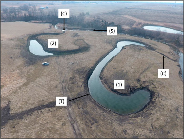
Figure 10. These drone images (February 2024; Photo credit: Brandon Iddings, Iowa Soybean Association) show the difference in hydrology of (1) a multi-purpose (tile-fed) and (2) a standard oxbow (no tile). Both oxbows were restored in Iowa in October 2023, but neither oxbow has connected with the adjacent stream (S). However, oxbow (1) has completely filled with water because it receives tile water (T), whereas oxbow (2) has only partially filled with water because it does not receive tile water; instead, the water in oxbow (2) groundwater that has seeped into the same elevation as the adjacent stream (S). A small connection (C) channel, similar in dimensions to a beaver slide, was excavated on the downstream end of both oxbows to increase the likelihood that each oxbow have a 2-year (50% annual chance) of connecting with the adjacent stream (S); note that the upstream end of both oxbows remained “plugged” with sediment.
Research on the impacts of different design characteristics can help improve future designs to maximize multiple benefits. Future research topics may include the best seeding techniques and seed mixes to effectively re-establish vegetation within and around the restored oxbow, the benefits of varying bank slopes (e.g., 1:1 vs. 4:1) and depths for longevity of oxbow and benefits to wildlife, and exploring the best flood frequency elevation of the connection channel to the adjacent stream for fish access and survival in the oxbow.
Although much research exists on the impacts of restored oxbows on fish and birds, future research could focus on other species such as mussels and amphibians.
Personal communication with farmers revealed that the excavated spoil spread in the adjacent farm field boosted yields for the farmer, however research could help confirm and bring increased attention to this benefit.
Finally, on a larger scale, it would be helpful to understand how many acres of oxbow restorations are needed within a watershed to improve water quality at the watershed scale, to provide a population level effect on wildlife, or to reduce flood peaks by a specific percentage.
This is not an exhaustive list of all the potential research opportunities that would benefit our understanding of restored oxbows and improve future restoration designs.
4 Discussion
In the 20 years of oxbow restoration practice in Iowa, lessons have been learned, steps have been added, omitted, and refined, research has been conducted, and partnerships have been built to produce the information in this manuscript. Inter-organizational collaboration has been identified as an essential ingredient in the success of each restoration project, with the government agencies, non-profits, and farmer-led organizations involved in this practice each contributing unique insights, capabilities, and resources. Leaning on these partner strengths has led to nearly 50 restoration projects being implemented in 1 year. As a result, in Iowa the Topeka Shiner is being considered for downlisting from an endangered species to a threatened species (USFWS, 2021), research has found a 62% average reduction in NO3-N in tile-fed oxbows (Pierce and Schilling, 2023), and hundreds of species have been found to inhabit or have some need met by restored oxbows.
Ultimately, as climate change and other human-driven landscape changes persist, healthy oxbows will continue play a key role in providing and sustaining essential environmental functions in floodplains throughout the world. However, significant challenges lie ahead. Foremost among them is minimizing the impacts of the Anthropocene on the further degradation of river systems and oxbows that currently exist on the landscape, while simultaneously designing and constructing resilient oxbow restorations that withstand the test of time in the face of human-caused change. Continued monitoring and expanded research are needed to provide insight into the ability of this practice to achieve present and future conservation goals. Therefore, our hope is that CSPs find the methods described herein as a useful addition to their conservation toolbox, and framework for adapting this practice in their pursuit of conservation objectives that benefit people, wildlife, and our river ecosystems.
Data availability statement
The original contributions presented in the study are included in the article/Supplementary Material, further inquiries can be directed to the corresponding author.
Author contributions
KW: Writing–original draft, Writing–review and editing. AR: Writing–original draft, Writing–review and editing. DW: Writing–original draft, Writing–review and editing. BI: Writing–original draft, Writing–review and editing. SW: Writing–original draft, Writing–review and editing.
Funding
The authors declare that no financial support was received for the research, authorship, and/or publication of this article.
Acknowledgments
We would like to give special thanks to the following organizations for reviewing the Oxbow Restoration Toolkit and for sharing their expertise and knowledge of oxbow restoration as a conservation practice. Natural Resources Conservation Service, Iowa Department of Natural Resources, U.S. Army Corps of Engineers, U.S. Fish and Wildlife Service, Iowa Department of Agriculture and Land Stewardship, Iowa Soybean Association, The Nature Conservancy.
Conflict of interest
The authors declare that the research was conducted in the absence of any commercial or financial relationships that could be construed as a potential conflict of interest.
Publisher’s note
All claims expressed in this article are solely those of the authors and do not necessarily represent those of their affiliated organizations, or those of the publisher, the editors and the reviewers. Any product that may be evaluated in this article, or claim that may be made by its manufacturer, is not guaranteed or endorsed by the publisher.
References
Carlson Mazur, M. L., Smith, B., Bird, B., McMillan, S., Pyron, M., and Hauswald, C. (2022). Hydrologic connectivity and land cover affect floodplain lake water quality, fish abundance, and fish diversity in floodplain lakes of the Wabash-White River Basin. River Res. Appl. 38, 160–172. doi:10.1002/rra.3888
Engaging Landowners (2024). Engaging landowners in conservation: a complete guide to designing programs and communications. Available at: https://www.engaginglandowners.org/sites/default/files/documents/resources/EngagementGuide-Complete.pdf (Accessed on January 10, 2024).
Fischer, J. R., Bakevich, B. D., Shea, C. P., Pierce, C. L., and Quist, M. C. (2018). Floods, drying, habitat connectivity, and fish occupancy dynamics in restored and unrestored oxbows of West Central Iowa, USA. Aquatic Conservation Mar. Freshw. Ecosyst. 28, 630–640. doi:10.1002/aqc.2896
Fuller, M. R., Doyle, M. W., and Strayer, D. L. (2015). Causes and consequences of habitat fragmentation in river networks. Ann. N.Y. Acad. Sci. ISSN, 31–51. doi:10.1111/nyas.12853
Gell, P., Fluin, J., Tibby, J., Hancock, G., Harrison, J., Zawadzki, A., et al. (2009). Anthropogenic acceleration of sediment accretion in lowland floodplain wetlands, Murray–Darling Basin, Australia. Geomorphology 108 (1–2), 122–126. doi:10.1016/j.geomorph.2007.12.020
Gleason, R. A., and Euliss, N. H. (1998). Sedimentation of prairie wetlands. Gt. Plains. Res. 8 (1), 97–112. Available at: https://digitalcommons.unl.edu/greatplainsresearch/363/.
Goetz, D., Miranda, L. E., Andrew, C., and Andrews, C. (2015). The role of depth in regulating water quality and fish assemblages in oxbow lakes. Environ. Biol. Fishes 98, 951–959. doi:10.1007/s10641-014-0330-z
Henning, J. A., and Sherato, G. (2006). Amphibian use of chehalis river floodplain wetlands. Northwest. Nat. 87, 209–214. doi:10.1898/1051-1733(2006)87[209:auocrf]2.0.co;2
Iowa Association of Naturalist (2001). Iowa waterways: Iowa’s biological community series. Available at: https://www.iowanaturalists.org/wp-content/uploads/2018/07/IAN205.pdf (Accessed on January 4, 2024).
Iowa Department of Natural Resources (2023). Permit and Environmental Review Management Tool (PERMT). Available at: https://programs.iowadnr.gov/permt/ [Accessed on November 10, 2023]
Iowa Flood Center (2023). Iowa flood risk management map. Available at: https://ifis.iowafloodcenter.org/ifis/newmaps/risk/map/ (Accessed on November 9, 2023).
Kondolf, G. M. (2011). Setting goals in river restoration: when and where can the river “heal itself”? Available at: https://calsalmon.org/sites/default/files/files/Kondolf_2011_SettingGoals.pdf (Accessed January 4, 2024).
Leberg, S., Osterhaus, D., Pierce, C., and Stewart, T. (2023). Restored oxbow wetlands within an agricultural landscape: using physical and biological characteristics to evaluate impacts of tile drainage input. Wetlands. doi:10.21203/rs.3.rs-3299444/v1
Natural Resources Conservation Service (2023a). Permit and Environmental Review Management Tool. Available at: https://programs.iowadnr.gov/permt/ (Accessed April 22, 2024).
Penfound, Wm. T. (1953). Plant communities of Oklahoma lakes. Ecology 34 (3), 561–583. doi:10.2307/1929728
Pierce, C. L., Simpson, N. T., Bybel, A. P., Zambory, C. L., Weber, M. J., and Roe, K. J. (2019). Status of the topeka shiner in Iowa. Am. Midl. Nat. 182, 109–117. doi:10.1674/0003-0031-182.1.109
Pierce, S., and Schilling, K. E. (2023). Nutrient retention in tile-fed and non-tile reconstructed oxbows in north central Iowa. J. Am. Water Resour. Assoc. 59 (5), 913–928. doi:10.1111/1752-1688.13124
Schilling, K. E., Haines, B. J., Jones, C. S., and St Clair, M. (2018a). Effectiveness of a newly reconstructed floodplain oxbow to reduce NO3-N loads from a spring flood. J. Environ. Manage. 215, 385–393. doi:10.1016/j.jenvman.2018.03.070
Schilling, K. E., Kult, K., Seemon, A., Wilke, K., and Jones, C. (2018b). Nitrate-N load reduction measured in a central Iowa restored oxbow. Ecol. Eng. 124, 19–22. doi:10.1016/j.ecoleng.2018.09.018
Schilling, K. E., Kult, K., Wilke, K., Streeter, M., and Vogelgesang, J. (2017). Nitrate reduction in a reconstructed floodplain oxbow fed by tile drainage. Ecol. Eng. 102, 98–107. doi:10.1016/j.ecoleng.2017.02.006
Schilling, K. E., Wilke, K., Pierce, C. L., Kult, K., and Kenney, A. (2019). Multipurpose oxbows as a nitrate export reduction practice in the agricultural Midwest. Agric. Environ. Lett. 4, 190035. doi:10.2134/ael2019.09.0035
Shaver, M. K., Giese, J. C., and Schulte, L. A. (2022). The effect of Oxbow Lake restoration on breeding birds in an agricultural landscape. Ecol. Restor. 40, 168–172. doi:10.3368/er.40.3.168
Simpson, N. T., Bybel, A. P., Weber, M. J., Pierce, C. L., and Roe, K. J. (2019). Occurrence, abundance, and associations of Topeka shiners (Notropis topeka) in restored and unrestored oxbows in Iowa and Minnesota, USA. Aquatic Conservation Mar. Freshw. Ecosyst., 1–14. doi:10.1002/aqc.3186
The Nature Conservancy (2021). Oxbow restoration Toolkit. Available at: https://www.nature.org/content/dam/tnc/nature/en/documents/Oxbow-Restoration-Toolkit.pdf (Accessed November 9, 2023).
U.S. Environmental Protection Agency (2023). Section 404 of the clean water Act. Available at: https://www.epa.gov/cwa-404/permit-program-under-cwa-section-404 (Accessed November 10, 2023).
U.S. Fish and Wildlife Service (2021). Collaborations leads to improved status of topeka shiner. Available at: https://www.fws.gov/press-release/2021-08/collaborations-leads-improved-status-topeka-shiner (Accessed on January 12, 2023).
U.S. Fish and Wildlife Service (2023). Environmental conservation online system - topeka shiner (Notropis topeka (=tristis)). Available at: https://ecos.fws.gov/ecp/species/4122 (Accessed on November 9, 2023).
Keywords: anthropocene, river, restoration, conservation, water quality, habitat, wildlife, climate change
Citation: Wilke K, Rust A, Weissenfluh D, Iddings B and Wulf S (2024) Shaping the future of conservation: a model for restoring oxbows in Iowa and beyond. Front. Environ. Sci. 12:1370512. doi: 10.3389/fenvs.2024.1370512
Received: 14 January 2024; Accepted: 11 April 2024;
Published: 28 May 2024.
Edited by:
Jason DeBoer, Illinois Natural History Survey, United StatesReviewed by:
Luther Aadland, Aadland River Restoration, United StatesKristen Bouska, United States Department of the Interior, United States
Copyright © 2024 Wilke, Rust, Weissenfluh, Iddings and Wulf. This is an open-access article distributed under the terms of the Creative Commons Attribution License (CC BY). The use, distribution or reproduction in other forums is permitted, provided the original author(s) and the copyright owner(s) are credited and that the original publication in this journal is cited, in accordance with accepted academic practice. No use, distribution or reproduction is permitted which does not comply with these terms.
*Correspondence: Karen Wilke, a3dpbGtlQHRuYy5vcmc=
†These authors have contributed equally to this work and share first authorship