 Tao Wu
 Zhen Yuan1
 Mingjing Li
94% of researchers rate our articles as excellent or good
Learn more about the work of our research integrity team to safeguard the quality of each article we publish.
Find out more
ORIGINAL RESEARCH article
Front. Environ. Sci. , 16 February 2024
Sec. Land Use Dynamics
Volume 12 - 2024 | https://doi.org/10.3389/fenvs.2024.1327535
As a promising planning strategy for urban sustainability, transit-oriented development (TOD) has been widely encouraged and adopted to integrate land use and transport systems. Because of the different applications in form, function and impact, it is necessary to explore context-based TOD typologies to better map the TOD specificities and focus on strategic planning. As the best-known method, the node-place model provides a useful analytical framework to evaluate TOD typologies. However, by using two indexes to aggregate the node and place value, details of some important TOD characteristics are disregarded in this model. Proposing a multi-axial indexes system, the butterfly model can perform a more detailed evaluation of node and place. In this research, we have revised and optimized the butterfly model and taken Tianjin Metro Line 1 as a case study. We find that all stations can be divided into five TOD types with significant spatial variations. TOD principles have already been implemented in Tianjin with good integration between metro system and land use. The method demonstrated in this paper equips urban planners with a useful tool for evaluating TOD performance and adopting more targeted strategies.
Rapid urbanization, accelerating population growth, and the overwhelming use of private transport worldwide have caused many urban problems, such as traffic congestion and environmental pollution (Yu et al., 2022). A fundamental reason for this phenomenon is the absence of clear and effective integration of land use with transportation (Vale et al., 2018). In recent decades, scholars and urban planners have been committed to proposing planning strategies to mitigate these adverse consequences (Li et al., 2019). Transit-oriented development (TOD) has been regarded as an efficient urban planning strategy for achieving such integration (Dou et al., 2021). The basic philosophy of TOD is advocating the geographic concentration and orderly construction of urban developments around public transport nodes and creating communities with moderate to high densities, diverse land use, and walkable street network (Cervero and Kockelman, 1997; Rahman et al., 2022). Metro transit systems, as the core of urban public transport, have gained increasing attention because of their fast-speed, heavy-passenger capacity, and low-pollution, and have been long playing a significant role in urban development. Metro stations provide greater accessibility to their surrounding areas and offer sufficient opportunities for high density and diversity development, as well as pedestrian-friendly neighbourhood environment (Malekzadeh and Chung, 2019). TOD put forward by Calthorpe takes land use and public transportation into consideration simultaneously and promotes diversified development in land use and the pedestrian-friendly environment (Calthorpe, 1993). Therefore, the implementation of TOD strategies in metro station areas has become a significant concern in the field of urban planning.
Although the basic philosophy of TOD can be applied to all metro station areas, not all metro stations present the same characteristics in form, function and impact. Therefore, there is an urgent need to develop context-based TOD typologies for better quantitatively evaluating TOD performance. The essence of TOD typology is to classify station areas with common morphological and functional characteristics (Lyu et al., 2016). Various studies have attempted to develop TOD typology based on the various features of stations and their surroundings, while the node-place model is the best-known and frequently-applied approach (Ibraeva et al., 2020).
However, limitations of this model, details of some important TOD characteristics which might be extremely useful for making planning are missed, if indexes were used to aggregate node and place value. Even though some effort of the extension of nod-place model has been made, the implementation is not efficient and sophisticated. What’s more, in the literature, studies mainly focused on TOD planning at spatial scales of station, city, and region. Typically, a metro line crosses different parts of a metropolis, requiring coordinated efforts at both the station and corridor levels (Liu et al., 2020; Su et al., 2021). Simply adding up individual TODs along metro corridors might fail to fully utilize the corridor advantages. Thus, conducting a baseline study to describe the locality-specific differences and similarities of TOD performance along the metro corridor is of paramount importance.
In this regard, this paper attempts to fill these gaps and develops an analytical model for TOD typologies in Chinese metropolises, focusing on corridor TOD. We extend the butterfly model with indicators which assess the characteristics of Chinese metropolises and follow the ‘three-Ds’ principles (density, diversity, and design) discerned by (Cervero and Kockelman, 1997). The butterfly model, a theoretical model which was introduced by Deltametropolis Association based on Bertolini’s node-place model is more efficient and easy-operating (Chorus, 2020). And the butterfly model treated as an extension of the node-place model by a multi-axial system presents a more detailed assessment of node and place and has become a promising solution which can tackle with the limitation mentioned above (Caset et al., 2018; Vale et al., 2018). Despite its benefits have been acknowledged, the butterfly model has not been used in Chinese TODs. Thus, the modified butterfly model is employed in this study to better explore the significant TOD characteristics and construct a framework for evaluation with Chinese context. A case study of Tianjin Metro Line 1 in China, illustrates the TOD typologies at the corridor scale.
TOD has been adopted as an effective sustainable planning strategy across the world to achieve the integration of transport systems and land use. Even though the basic philosophy of TOD seems to be similar in all contexts, literature has shown a great deal of variation in its application for cases (Phani Kumar et al., 2020). For example, in America, TOD focuses mainly on re-centering suburban sprawl around transit nodes (Ewing et al., 2017). In Netherlands, TOD underlines the redevelopment of existing transit neighbourhoods (Singh et al., 2017). In India, TOD is regarded as a means of channelling metropolitan growth along transit corridors (Phani Kumar et al., 2018). Recent studies have developed typologies based on the characteristics of the existing urban structure, in order to reveal the spatial variation in TOD application. TOD typology is beneficial to urban planners and decision-makers to develop more targeted strategies based on the similar characteristics of each type.
There are two main methodologies in recent literature for developing TOD typologies: qualitative description and quantitative analysis. The qualitative description involves classifications based on the geographical and functional characteristics of neighbourhoods, whereas the quantitative analysis involves classifications by the quantitative segmentation of neighbourhoods (Phani Kumar et al., 2020). With the advantages of being able to test, analyze and compare, the development of quantitative analysis becomes more and more of significance for quantifying spatial diversity of TODs (Yang et al., 2021). The best-known approach for quantitatively segmenting neighbourhoods into TOD typologies is the node-place model. Developed by (Bertolini, 1999), the model integrates environmental characteristics into two dimensions: node and place (Figure 1). The node dimension refers to transport characteristics, and the place dimension represents urban development characteristics. The basic principle of the node-place model is balancing these two dimensions to achieve a state of integration of transport and urban development (Zhang et al., 2019).
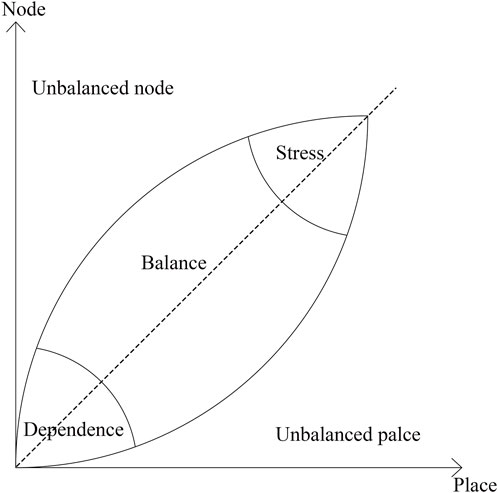
FIGURE 1. The node-place model (Bertolini, 1999).
Over the past 2 decades, the node-place model has been expanded in methodology and applications. One major modification is the expansion of indicators while maintaining the two original node and place indexes. Reusser et al. (2008) developed six indicators in addition to those proposed in the original model based on expert questionnaires. Monajem and Nosratian (2015) added spatial indices which might determine the structure of station area development. In addition to adding different indicators, some scholars introduced a third dimension to extend the node place model, considering factors such as the urban design features (Vale, 2015; Vale et al., 2018; Zheng and Austwick, 2023), the functional and morphological interrelation between transportation and urban conditions (Lyu et al., 2016; Su et al., 2021; Cummings and Mahmassani, 2022), traveller-related attributes (Cao et al., 2020; Dou et al., 2021; Zhou et al., 2023), and ecological environment (Yang et al., 2023).
Although several improvements have been made to the node-place model, they still have limitations. Using indexes to aggregate information about the two or three dimensions, some important types of detailed TOD features are missed. Therefore, one possible enhancement of the node-place model is to propose a multi-axial model to perform a detailed evaluation. Caset et al. (2018) has done a pioneer study along this line and introduced the butterfly model. This model is similar to the shape of a butterfly because it has two “wings”: the left-wing contains node-related indicators, while the right-wing contains place-related indicators (Figure 2). Each wing can also be divided into different parts instead of using a simple aggregated index. In this theoretical idea, each site area consists of a node value and a place value. The node value represents the traffic supply of a site area and the place value represents the spatial development of a site area. The model increases the node value of a location by improving accessibility, thereby creating favourable conditions for further development of the location. In turn, a place develops because of its growing transport demand, which favours the promotion of further development of the transport system. It assumes that a site area functions optimally when the node and location values are balanced. The butterfly model further elaborates this point. It is based on three salient features of node value and three salient features of place value. The determinants of node value are its status in the public transport, road and cycle networks. The determinants of place value are the density of residents, workers and tourists, the mix of land uses and their centrality. The latter refers to the extent to which the station itself functions as the centre of its surroundings. The butterfly model locates the interrelationships of these six features, i.e., the node values represent the positional values of the left wing and the place values representing the right wing. The station area functions best when the two wings of the butterfly are in balance with each other. The minimum requirement for a station area is that its location in the public transport network should match the density of residents, workers and tourists.
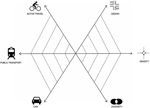
FIGURE 2. The butterfly model applied to the Brussels RER network (Caset et al., 2018).
Compared to previous approaches, the butterfly model is able to evaluate TOD characteristics in more detail. And this more disaggregate way to visualize the components of each dimension allows urban planners to better evaluate and understand the development status of metro stations.
Although the butterfly model can be applied to all major cities around the world, the indexes must be modified to reflect the characteristics of TODs in China. We optimize the butterfly model based on the characteristics of TODs in China. We have constructed three first-class indexes at the node dimension and place dimension respectively. The node dimension is linked to the accessibility of the station and can be divided into three facets: accessibility of metro mode, accessibility of bus feeder mode, and accessibility of bicycle feeder mode. In terms of the place dimension, we add environmental features and spatial parameters into it and recategorize the place dimension following the ‘three-Ds’ principles (density, diversity, and design) discerned by (Cervero and Kockelman, 1997). Finally, the butterfly model with six indexes’ system is established, which is constituted by two levels: 6 first-class indexes and 21 second-class indicators. Below, a more thorough discussion of the indicators’ operationalization will be provided.
Figure 3 illustrates the butterfly model we developed for the context of China. According to the TOD theory, the Chinese 10-min life circle (Peng et al., 2023), and observations of walking distance in Tianjin (Wu and Yan, 2020), this study’s analysis threshold of distance is defined as 600 m. Eleven second-class indicators of node dimension are presented in Table 1. Table 1 also includes the ten second-class indicators of place dimension.
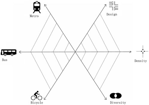
FIGURE 3. The butterfly model for the context of China.
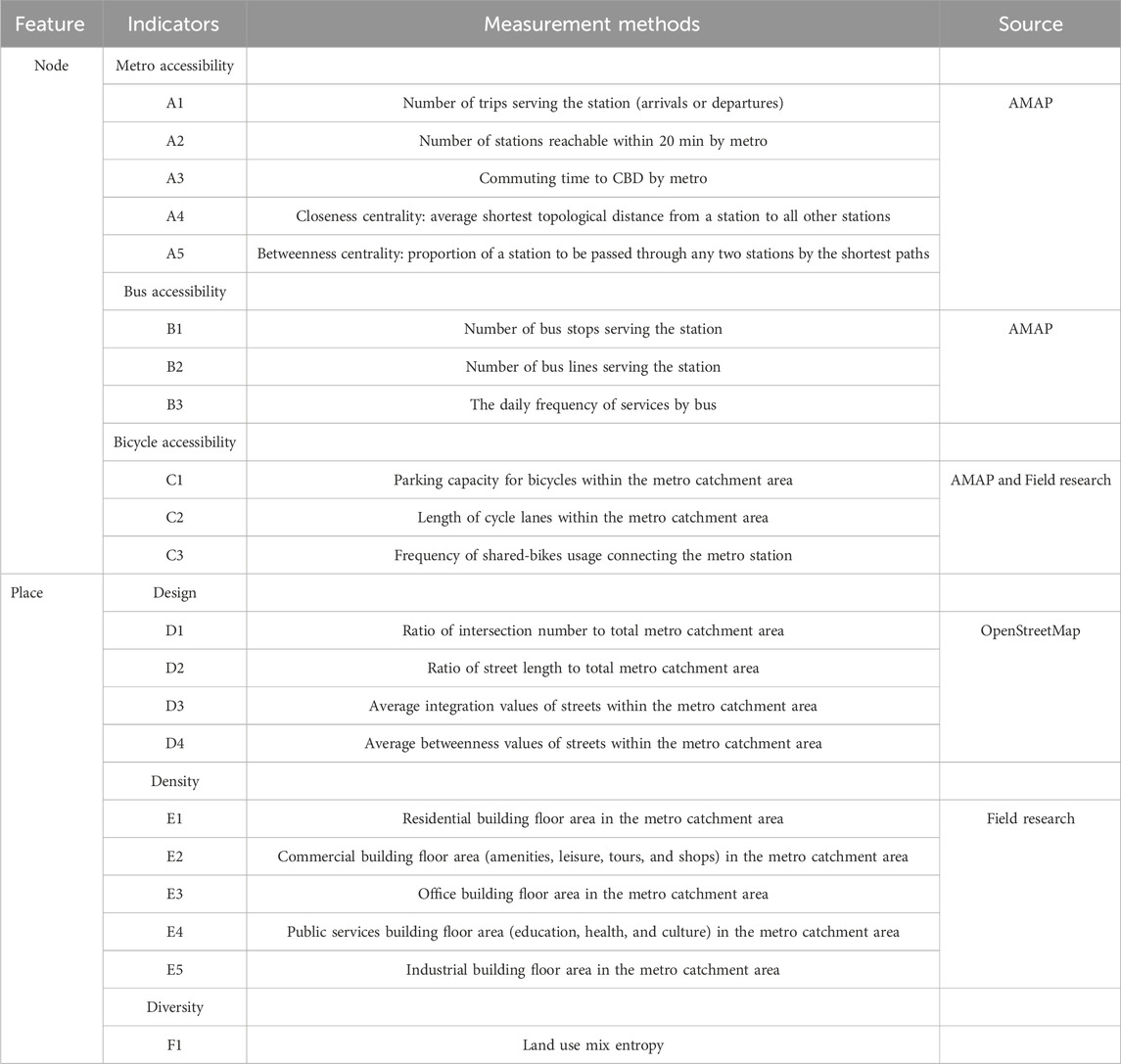
TABLE 1. Indicators overview and measurement.
Metro accessibility measures the accessibility of the metro stations and consists of five secondary-class indicators. A1-A3 reflect the geographical connectivity of the metro network which was used by (Lyu et al., 2016). Specifically, indicator A1 indicates the total number of trips (arrivals or departures) served by the metro. Indicator A2 measures the number of reachable stations with 20min by metro. Indicator A3 indicates the travel times to Central Business District (CBD) by metro.
When using the metro, passengers usually have a vague perception of space and distance, and they are more concerned about the number of transfers and stations passing through (Li et al., 2017). Thus, space syntax analysis earlier utilized by (Wu and Zhou, 2022) on topological connectivity of the metro network is adapted in this paper. Indicator A4 measures the closeness centrality which is defined as the average shortest topological distance from a station to all other stations in the metro network, while indicator A5 measures the betweenness centrality which is defined as the proportion of a station to be passed through between any two stations by the shortest paths. Reflecting the possibility that people access and traverse stations, these two indicators are calculated by Depthmap, a Space syntax software.
Bus accessibility presents the ease of interchanging between metro and bus systems, and consists of three second-class indicators that are in line with (Caset et al., 2018) and other studies (Vale et al., 2018; Cao et al., 2020). Indicator B1 measures the number of bus stops serving the station. Indicator B2 measures the number of bus lines serving the station. Indicator B3 indicates the daily frequency of services by bus. All these data are collected from AMAP.
Bicycle accessibility presents the ease of interchanging between metro and bicycle, and includes three second-class indicators used in (Caset et al., 2018; Rodríguez and Kang, 2020). Indicator C1 measures the bicycle parks within the metro catchment area. Indicator C2 measures the length of bicycle lanes within the metro catchment area. With the development of bike-sharing services in China, it provides a new way for the feeder mode. Therefore, we add indicator C3 which measures the frequency of shared-bikes usage connecting the metro station. Data for indicators C1, C2 and C3 are collected by the AMAP and field research.
Urban design is regarded as a significant feature of TODs, since it has a major impact on metro patronage and active ways of travel. We measure design value by two facets: walking environment and spatial parameters. The intersection density (D1) and the street network density (D2) are selected as walkability indicators which were used in earlier work by (Su et al., 2021) and both of them were calculated by processing the Tianjin road network downloaded in OpenStreetMap in ArcGIS software. In reference to the work of (Pezeshknejad et al., 2020), space syntax analysis is used to quantify spatial parameters, including the street integration (D3) and the street betweenness (D4). Indicator D3 measures average integration values after angular analysis in terms of walking radius (600 m) within the metro catchment area in Depthmap software, reflecting the ability of a space to attract arriving traffic as a destination, the higher the integration degree of the space, the higher the accessibility, the stronger the centrality, the easier it is to gather people. Indicator D4 measures the average betweenness value after angular analysis in terms of walking radius (600 m) within the metro catchment area in Depthmap software, reflecting the possibility that people traverse space, the higher street betweenness of the space, the more likely it is to be walked through.
Development density reflects the concentration of different urban functions within the metro catchment area. Caset et al. (2018) used official home and office addresses to calculate the number of residents and jobs. While this study focuses on the local scale, official statistical data can not accurately reflect urban development. Therefore, we use the floor area of various urban functions which are absent from previous studies to measure development density. There are five second-class indicators, including E1-residential building floor area, E2-commercial building floor area (amenities, leisure, tourism, and shops), E3-office building floor area, E4-public services building floor area (education, health, and culture), and E5-industrial building floor area.
Diversity reflects the functional mix of land use and can be measured by land use mix entropy in Eq. 1 (Sun and Ren, 2021). We consider the five density indicators E1, E2, E3, E4 and E5 in calculating the diversity.
Where
Cluster analysis is then applied to identify the classes which have common TOD features. Two-step cluster analysis is employed in this study in line with (Phani Kumar et al., 2020). Compared with k-means clustering (Zhang et al., 2019) and hierarchical clustering (Rodríguez and Kang, 2020), this method has two advantages. First, it can deal with categorical and continuous variables efficiently. More importantly, two-step cluster analysis can automatically determine the optimal cluster numbers. Before cluster analysis, we use the Min-Max standard method to normalize and standardize all the indicators between 0 and 1. In Eq. 2, Xij is the value of indicator i for station j, max Xij is the maximum value and min Xij is the minimum value of indicator i for all stations. Positives represent a greater value with a positive contribution and negatives denote a higher value with a negative contribution.
Almost all indicators are positively correlated with the logic of the butterfly model, with the exception of A3. Then, each first-class index is calculated by the average of all second-class indicators referring to them.
China is undergoing rapid urbanization and massive expansion of metro network during the past decades. While the metro systems have become the backbones of public transit, the implementation of TOD is considered as a potential solution for the sustainable development of metropolises in China. As the second city with a metro system in China, Tianjin began to operate the metro system in 1984. The metro system in Tianjin has undergone notable growth since 2006, and the total mileage increased from 26 km in 2006 to 238 km in 2019. As of 2019, there were 6 metro lines with 157 stations, and the daily ridership reached 1.44 million. The metro is responsible for more than 60% of Tianjin’s public transport patronage, improving the travelling conditions of the residents and driving the development of the surrounding land.
Among these metro corridors, Metro Line 1 is the earliest metro line in Tianjin. With a total of 23 stations in operation, Metro Line 1 passes through six administrative districts, namely, Beichen District, Hongqiao District, Nankai District, Heping District, Hexi District and Jinan District, making it the metro line with the largest passenger flows (Figure 4). It is noteworthy that Metro Line 1 has undergone several decades of development, boasting relatively well-established facilities. The government has demonstrated commitment to sustainable urban development, thereby fostering the application of TOD principles in this area. This gives Tianjin Metro Line 1 an initial foundation in the field of TOD research.
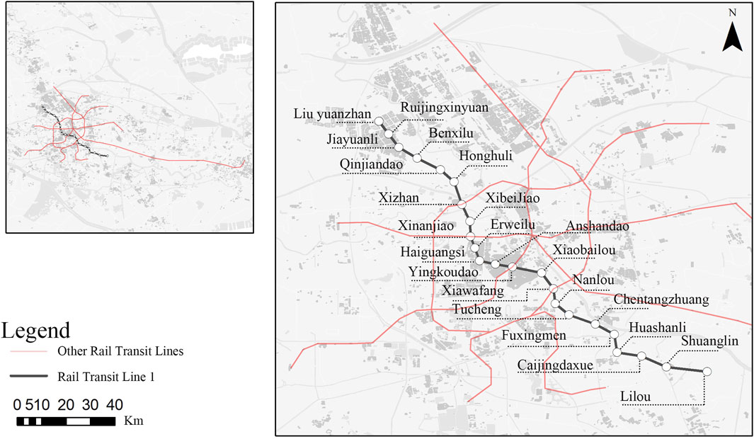
FIGURE 4. Study area and Tianjin metro system.
The interaction between metro stations and the surrounding environment occurs in a certain area, so it is necessary to delimit the size of the catchment area of the metro stations. Previous researches have demonstrated various case-specific distance thresholds, such as a radial distance varying from 400m to 800 m (Reusser et al., 2008; Zemp et al., 2011; Wu et al., 2023), or a walking distance varying from 10-min to 15-min (Singh et al., 2017; Li et al., 2019). Wu and Yan (2020) used methods of GPS tracking and observation to obtain more accurate walking characteristics which connect metro service, demonstrating that 600 m could be the comfortable walking distance in Tianjin (Wu and Yan, 2020). According to the TOD theory and observations of walking distance in Tianjin, we use 600 m as the delineation threshold of each station to define TOD areas. This specific threshold value can reduce boundary overlaps between station areas and better reflect the characteristics of each station area. The basic spatial data, such as land use and shared-bikes usage, was obtained by field research. The urban big data such as street network and station information, was collected by Python crawler from the office website, OpenStreetMap and AMAP. More details about data sources have been shown in Table 1.
The twenty-three stations have been classified into five types by the two-step cluster analysis, namely, urban TODs, balanced TODs, specific TODs, future TODs, and unbalanced TODs. Each of the five categories has their own unique characteristics. Their spatial distributions are illustrated in Figure 5, while their corresponding numerical distributions and realistic circumstance of the representative stations of each cluster are displayed in Figure 6. Table 2 reports the levels of TOD indexes of each cluster.
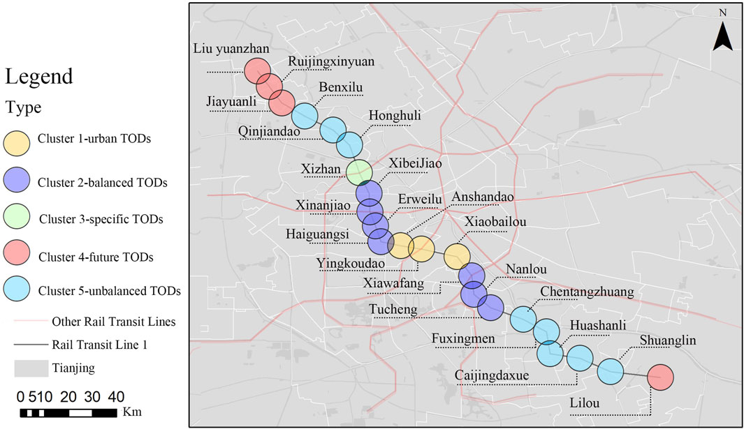
FIGURE 5. Geographical distribution of the five station types based on the butterfly model.
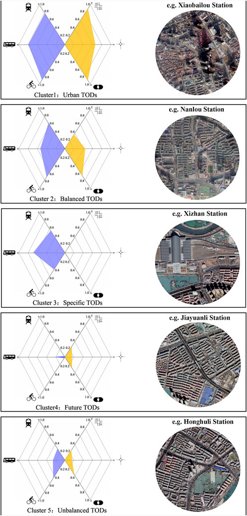
FIGURE 6. Overview of TOD types and characteristics and realistic circumstance of the representative stations of each cluster.
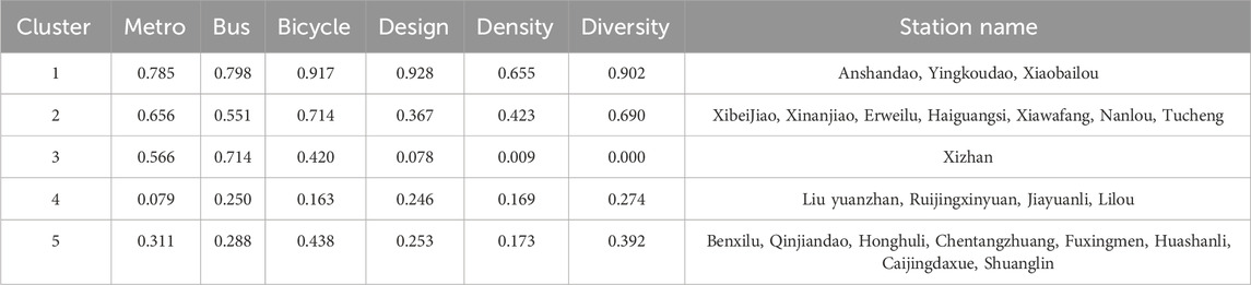
TABLE 2. Cluster description and summary means on indicators.
Three stations are classified as the urban TODs. The main features distinguishing this cluster from the other ones are the highest scores of all indexes. Located in the city center and serving the CBD, these stations have characteristics of high-density development, diverse land use and pedestrian-friendly street network. On the inner palm of the metro network, these stations have the highest metro accessibility and are easy to reach other stations. There are also adequate bus and bicycle facilities in the metro catchment area. Cluster 1 is balanced and performs at maximum efficiency.
Cluster 2 is a big cluster and the number of stations is 7. Cluster 2 is similar to cluster 1 with a balanced development status, but the values of all the six indexes are lower. It is noteworthy that cluster 1 and cluster 2 are all located in the urban areas, but cluster 2 is further from the city center. The values of most indexes are just above the average, except the design index, which is slightly below the average. Overall, this cluster exhibits a balanced butterfly visualization, with a slight inferiority of place features due to the low value of the design index.
Cluster 3 includes only one station, namely, Xizhan. As the most special station, it is a transport hub for high-speed railways and the metro system, and has relatively high metro accessibility and bus accessibility, as well as moderate bicycle accessibility. However, the values of the three place indexes are extremely low. Apart from the traffic function, there are few other urban functions in the catchment area. At the same time, the connectivity of the street network around the station is poor due to the fragmentation of the railway line. It fails to fully recognize the catalytic effect of a transport hub for regional economy.
Future TODs (the number of stations is 4), is characterized by the lowest scores of all indexes. Located at the ends of the metro line and far away from the interchange stations, these stations display inadequate accessibility. Meanwhile, located in the city periphery, their urban development is also insufficient and in lower demand for transportation. But they are more likely to constitute TODs in the future than those areas without metro system, and should be given additional attention. The expansion of metro network can also promote the accessibility of these stations, and may change the type of these stations.
Cluster 5 has the majority of stations (the number of stations is 8), which is distinguished by a low score on density index, but moderate scores on the other indexes. Despite having a comparatively low place value to cluster 4, cluster 5 has a substantially greater node value, mainly because stations in cluster 5 are geographically closer to the centre of the metro network and have a higher degree of accessibility. In general, transport facilities are more developed than urban activities in cluster 5, which formed an unbalanced situation.
TOD profoundly influences urban development, enhances transportation efficiency, boosts economic vitality by attracting businesses and creating jobs, optimizes land use, fosters community cohesion, improves environmental quality, and increases property values. Overall, TOD serves as a catalyst for sustainable urban growth by addressing transportation, economic, social, and environmental aspects. The TOD typology of metro stations provides valuable insights into TOD planning, equipping city managers and planners with a useful tool for developing more targeted strategies and avoiding the ‘one-size-fits-all’ solution. On the whole, the TOD development of Tianjin Metro Line 1 shows a “high-medium-low” spatial disparity from the city centre to the suburbs, presenting an obvious urban transect. Relative to its transportation supply, the degree of development of Cluster 3 is exceptionally low and it might be given priority by urban planners to maximize the benefits of investment. This may include increasing public service facilities, improving transportation connectivity, and attracting commercial investments. Elevating the development in this area could effectively balance urban development disparities and maximize investment returns. Cluster 1 has the highest indexes and the development potential has been fully exploited. For this cluster, it can be regarded as an organism integrating the metro and land use planning. “Urban Acupuncture”, which is a strategy of urban renewal focusing on the key urban area, could be used to stimulate urban vitality and emphasis should shift towards sustainable development measures, emphasizing the integration of urban planning and environmental conservation to ensure long-term sustainability. Although exhibiting a balanced butterfly visualization, cluster 2 can achieve a more ideal development pattern by improving pedestrian-friendly environment. Improving the quality and convenience of sidewalks would further optimize its development pattern, enhancing the region’s attractiveness and residents’ quality of life. Regarding Cluster 5’s relatively low density, exploring high-density development strategies is suggested. Advocating for moderate high-density development may enhance accessibility and attractiveness, promoting TOD’s advancement in the area.
In this paper, we use the revised and optimized butterfly model to assess the TOD typologies in the metropolitan context of China. Although the original node-place model is very simple and powerful as a framework for investigating the interaction between transport and land use, details of some important characteristics are disregarded by using indexes to aggregate node and place values. Using the multi-axial approach to extend the node-place model, the butterfly model can perform a more detailed evaluation and generate a better understanding of TOD characteristics. An empirical case study of Tianjin Metro Line 1 demonstrates the effectiveness of the approach.
This study obtains three major findings. First, the analysis reveals that stations in Tianjin Metro Line 1 have good integration between the metro system and land use, indicating that TOD principles have already been implemented. However, some stations need more attention because of the mismatch between the node and place value. Second, we identify five TOD typologies, which reflect different degrees of metro network accessibility, bus service, bicycle service, density, diversity and design, and they present significant spatial variations. The number of TOD typologies in this study is in line with the previous study (Wu and Yan, 2020), but more details and TOD characteristics are found under the modified butterfly model. Cluster 1 is located in the centre of the city with the highest scores on all indicators, whereas cluster 4 is located at the ends of the metro lines and the suburb areas with the low scores on all indicators. Cluster 2 is similar to cluster 1 with a balanced development status, but the scores are much lower. Cluster 3 includes only one station, namely, Tianjin West Railway Station. As an urban transportation hub, it has not developed too many urban functions except the transportation function. As for cluster 5, the values of node indexed are much higher than that of place indexes, exhibiting an unbalanced situation. Third, our focus on the metro corridor finds that stations with high TOD index values are located in the urban centre, and the TOD index values show high-medium-low spatial disparity from city centre to suburb areas. It means that TOD constructions in Tianjin’s central urban area are very effective.
This study presents several limitations. First, the differences in the weight of the indicators are not considered in the construction of the indicator system, and methods such as Analytic Hierarchy Process and Entropy Weighting (Yang et al., 2023) can be used in future research to identify the weight of each indicator. Second, focusing on one corridor Tianjin Metro Line 1, we do not consider the differences between corridors, and comparative analysis among different corridors can be conducted in the future. Finally, the aspect of the population, such as resident and employee also have not been taken into consideration in this study and this aspect should not be ignored in the future study.
The raw data supporting the conclusion of this article will be made available by the authors, without undue reservation.
TW: Conceptualization, Funding acquisition, Investigation, Methodology, Software, Writing–original draft, Writing–review & editing. ZY: Conceptualization, Data curation, Software, Validation, Writing–original draft. LG: Conceptualization, Methodology, Writing–review & editing. MZ: Methodology, Validation, Writing–original draft. ML: Conceptualization, Investigation, Methodology, Validation, Writing–original draft.
The author(s) declare financial support was received for the research, authorship, and/or publication of this article. This work is supported by Wuhan Science and Technology Bureau, grant number 2022010801020310; Philosophy and Social Sciences Research Project of Department of Education of Hubei Province, grant number 22Q025; Hubei Changjiang National Cultural Park Construction Research Project, Hubei Provincial Department of Culture and Tourism, grant number HCYK 2022Y08; and 2021 Construction Science and Technology Plan Project of Department of Housing and Urban-Rural Development of Hubei Province, grant number 202115.
Author LG was employed by Central & Southern China Municipal Engineering Design And Research Institute, Co., Ltd. Author MZ was employed by Beijing Urban Construction Design and Development Group Co., Limited.
The remaining authors declare that the research was conducted in the absence of any commercial or financial relationships that could be construed as a potential conflict of interest.
All claims expressed in this article are solely those of the authors and do not necessarily represent those of their affiliated organizations, or those of the publisher, the editors and the reviewers. Any product that may be evaluated in this article, or claim that may be made by its manufacturer, is not guaranteed or endorsed by the publisher.
Bertolini, L. (1999). Spatial development patterns and public transport: the application of an analytical model in The Netherlands. Plan. Pract. Res. 14, 199–210. doi:10.1080/02697459915724
Calthorpe, P. (1993). The next American metropolis: ecology, community, and the American dream. Hudson, NY, USA Princeton architectural press.
Cao, Z., Asakura, Y., and Tan, Z. (2020). Coordination between node, place, and ridership: comparing three transit operators in Tokyo. Transp. Res. Part D Transp. Environ. 87, 102518 doi:10.1016/j.trd.2020.102518
Caset, F., Vale, D. S., and Viana, C. M. (2018). Measuring the accessibility of railway stations in the Brussels regional express network: a node-place modeling approach. Netw. Spatial Econ. 18, 495–530. doi:10.1007/s11067-018-9409-y
Cervero, R., and Kockelman, K. (1997). Travel demand and the 3Ds: density, diversity, and design. Transp. Res. Part D Transp. Environ. 2, 199–219. doi:10.1016/s1361-9209(97)00009-6
Chorus, P. (2020). 25. Making places with transit-oriented development: the case of north holland. Handbook of Sustainable Transport. Edward Elgar Publishing, 238.
Cummings, C., and Mahmassani, H. (2022). Does intercity rail station placement matter? Expansion of the node-place model to identify station location impacts on Amtrak ridership. J. Transp. Geogr. 99, 103278. doi:10.1016/j.jtrangeo.2022.103278
Dou, M., Wang, Y., and Dong, S. (2021). Integrating network centrality and node-place model to evaluate and classify station areas in Shanghai. ISPRS Int. J. Geo-Information 10, 414. %@ 2220-9964. doi:10.3390/ijgi10060414
Ewing, R., Tian, G., Lyons, T., and Terzano, K. (2017). Trip and parking generation at transit-oriented developments: five US case studies. Landsc. Urban Plan. 160, 69–78. doi:10.1016/j.landurbplan.2016.12.002
Ibraeva, A., Correia, G. H. D. A., Silva, C., and Antunes, A. P. (2020). Transit-oriented development: a review of research achievements and challenges. Transp. Res. Part A Policy Pract. 132, 110–130. doi:10.1016/j.tra.2019.10.018
Li, L., Ren, H., Zhao, S., Duan, Z., Zhang, Y., and Zhang, A. (2017). Two dimensional accessibility analysis of metro stations in Xi’an, China. Transp. Res. Part A Policy Pract. 106, 414–426. doi:10.1016/j.tra.2017.10.014
Liu, L., Zhang, M., and Xu, T. (2020). A conceptual framework and implementation tool for land use planning for corridor transit oriented development. Cities 107, 102939. doi:10.1016/j.cities.2020.102939
Li, Z., Han, Z., Xin, J., Luo, X., Su, S., and Weng, M. (2019). Transit oriented development among metro station areas in Shanghai, China: variations, typology, optimization and implications for land use planning. Land Use Policy 82, 269–282. doi:10.1016/j.landusepol.2018.12.003
Lyu, G., Bertolini, L., and Pfeffer, K. (2016). Developing a TOD typology for Beijing metro station areas. J. Transp. Geogr. 55, 40–50. doi:10.1016/j.jtrangeo.2016.07.002
Malekzadeh, A., and Chung, E. (2019). A review of transit accessibility models: challenges in developing transit accessibility models. Int. J. Sustain. Transp. 14, 733–748. doi:10.1080/15568318.2019.1625087
Monajem, S., and Nosratian, F. E. (2015). The evaluation of the spatial integration of station areas via the node place model; an application to subway station areas in Tehran. Transp. Res. D Transp. Environ. 40, 14–27.
Peng, J., Liu, Y., Ruan, Z., and Yang, H. (2023). Study on the optimal allocation of public service facilities from the perspective of living circle—a case study of Xiangyang High-tech Zone, China. J. Urban Manag. 12, 344–359. doi:10.1016/j.jum.2023.07.004
Pezeshknejad, P., Monajem, S., and Mozafari, H. (2020). Evaluating sustainability and land use integration of BRT stations via extended node place model, an application on BRT stations of Tehran. J. Transp. Geogr. 82, 102626. doi:10.1016/j.jtrangeo.2019.102626
Phani Kumar, P., Ravi Sekhar, C., and Parida, M. (2018). Residential dissonance in TOD neighborhoods. J. Transp. Geogr. 72, 166–177. doi:10.1016/j.jtrangeo.2018.09.005
Phani Kumar, P., Ravi Sekhar, C., and Parida, M. (2020). Identification of neighborhood typology for potential transit-oriented development. Transp. Res. Part D Transp. Environ. 78, 102186. doi:10.1016/j.trd.2019.11.015
Rahman, M. H., Ashik, F. R., and Mouli, M. J. (2022). Investigating spatial accessibility to urban facility outcome of transit-oriented development in Dhaka. Transp. Res. Interdiscip. Perspect. 14, 100607. doi:10.1016/j.trip.2022.100607
Reusser, D. E., Loukopoulos, P., Stauffacher, M., and Scholz, R. W. (2008). Classifying railway stations for sustainable transitions – balancing node and place functions. J. Transp. Geogr. 16, 191–202. doi:10.1016/j.jtrangeo.2007.05.004
RodríGUEZ, D. A., and Kang, C.-D. (2020). A typology of the built environment around rail stops in the global transit-oriented city of seoul korea. Cities, 100, 102663 doi:10.1016/j.cities.2020.102663
Singh, Y. J., Lukman, A., Flacke, J., Zuidgeest, M., and Van Maarseveen, M. F. A. M. (2017). Measuring TOD around transit nodes - towards TOD policy. Transp. Policy 56, 96–111. doi:10.1016/j.tranpol.2017.03.013
Sun, W., and Ren, C. (2021). The impact of energy consumption structure on China’s carbon emissions: taking the Shannon–Wiener index as a new indicator. Energy Rep. 7, 2605–2614. doi:10.1016/j.egyr.2021.04.061
Su, S., Zhang, H., Wang, M., Weng, M., and Kang, M. (2021). Transit-oriented development (TOD) typologies around metro station areas in urban China: a comparative analysis of five typical megacities for planning implications. J. Transp. Geogr. 90, 102939. doi:10.1016/j.jtrangeo.2020.102939
Vale, D. S. (2015). Transit-oriented development, integration of land use and transport, and pedestrian accessibility: combining node-place model with pedestrian shed ratio to evaluate and classify station areas in Lisbon. J. Transp. Geogr. 45, 70–80. doi:10.1016/j.jtrangeo.2015.04.009
Vale, D. S., Viana, C. M., and Pereira, M. (2018). The extended node-place model at the local scale: evaluating the integration of land use and transport for Lisbon's subway network. J. Transp. Geogr. 69, 282–293. doi:10.1016/j.jtrangeo.2018.05.004
Wu, T., Li, M., and Zhou, Y. (2023). Measuring metro accessibility: an exploratory study of wuhan based on multi-source urban data. ISPRS Int. J. Geo-Information 12, 18. doi:10.3390/ijgi12010018
Wu, T., and Yan, J. (2020). Accessibility measurement and evaluation of urban rail transit stations: an application in Tianjin. Geogr. Geo-Information Sci. 36, 75–81.
Wu, T., and Zhou, Y. (2022). Measuring the accessibility of metro stations in Tianjin: an origin-destination approach. J. Asian Archit. Build. Eng. 22, 693–704. doi:10.1080/13467581.2022.2049276
Yang, B., Ling, L., Tangshan, H., and Dazhi, J. (2021). TOD typology: a review of research achievements. J. Southeast Univ. Ed. 37, 11. doi:10.3969/j.issn.1003.7985.2021.03.011
Yang, W., Yan, W., Chen, L., Wei, H., and Gan, S. (2023). Developing a TOD assessment model based on node–place–ecology for suburban areas of metropolitan cities: a case in Odawara. Environ. Plan. B Urban Anal. City Sci. 0(0), 1–15. doi:10.1177/23998083231202880
Yu, Z., Zhu, X., and Liu, X. (2022). Characterizing metro stations via urban function: thematic evidence from transit-oriented development (TOD) in Hong Kong. J. Transp. Geogr. 99, 103299. doi:10.1016/j.jtrangeo.2022.103299
Zemp, S., Stauffacher, M., Lang, D. J., and Scholz, R. W. (2011). Classifying railway stations for strategic transport and land use planning: context matters. J. Transp. Geogr. 19, 670–679. doi:10.1016/j.jtrangeo.2010.08.008
Zhang, Y., Marshall, S., and Manley, E. (2019). Network criticality and the node-place-design model: classifying metro station areas in Greater London. J. Transp. Geogr. 79, 102485. doi:10.1016/j.jtrangeo.2019.102485
Zheng, L., and Austwick, M. Z. (2023). Classifying station areas in greater Manchester using the node-place-design model: a comparative analysis with system centrality and green space coverage. J. Transp. Geogr. 112, 103713. %@ 0966-6923. doi:10.1016/j.jtrangeo.2023.103713
Keywords: metro station, transit-oriented development (TOD), typology, butterfly model, China
Citation: Wu T, Yuan Z, Gao L, Zhang M and Li M (2024) TOD typologies for metro stations based on the butterfly model. Front. Environ. Sci. 12:1327535. doi: 10.3389/fenvs.2024.1327535
Received: 25 October 2023; Accepted: 05 February 2024;
Published: 16 February 2024.
Edited by:
Riccardo Buccolieri, University of Salento, ItalyReviewed by:
Yalcin Yildirim, Bursa Technical University, TürkiyeCopyright © 2024 Wu, Yuan, Gao, Zhang and Li. This is an open-access article distributed under the terms of the Creative Commons Attribution License (CC BY). The use, distribution or reproduction in other forums is permitted, provided the original author(s) and the copyright owner(s) are credited and that the original publication in this journal is cited, in accordance with accepted academic practice. No use, distribution or reproduction is permitted which does not comply with these terms.
*Correspondence: Tao Wu, d3V0YW9Ad3VzdC5lZHUuY24=
Disclaimer: All claims expressed in this article are solely those of the authors and do not necessarily represent those of their affiliated organizations, or those of the publisher, the editors and the reviewers. Any product that may be evaluated in this article or claim that may be made by its manufacturer is not guaranteed or endorsed by the publisher.
Research integrity at Frontiers
Learn more about the work of our research integrity team to safeguard the quality of each article we publish.