 Lijun Ma1
 Shi Yin
94% of researchers rate our articles as excellent or good
Learn more about the work of our research integrity team to safeguard the quality of each article we publish.
Find out more
ORIGINAL RESEARCH article
Front. Environ. Sci., 30 October 2023
Sec. Environmental Economics and Management
Volume 11 - 2023 | https://doi.org/10.3389/fenvs.2023.1294180
This article is part of the Research TopicRealization of Ecological Product Value, Land Use Change and EnvironmentView all 11 articles
This study focuses on the counties and districts of Hebei Province as the research unit. It adopts a supply-demand perspective to analyze the spatial-temporal evolution characteristics of farmland utilization transformation in the province, investigate the coordination of this transformation, and explore the influencing factors. The weight of indicators is calculated using the entropy weighting method and Analytic Hierarchy Process The comprehensive evaluation model is then applied to calculate the supply-demand transformation index of farmland utilization in Hebei Province for the years 2005, 2010, 2015, and 2020. Furthermore, the spatial-temporal evolution characteristics are analyzed using the kernel density estimation method. The coupling coordination degree model is selected to explain the relationship between the supply-demand transformation of farmland utilization. Finally, the influencing factors are analyzed using the geographical detector model. The research findings are as follows: 1) The supply-demand transformation index of farmland utilization in Hebei Province has shown an increasing trend during the study period. The standard deviation of the supply transformation index has increased over time, while the demand transformation index has increased at a faster rate. High-density supply transformation is concentrated in the southeast, particularly in the eastern part of Shijiazhuang. Conversely, the northwest exhibits a low-density supply transformation. High-density demand transformation is observed in urban areas across the province, with a significant expansion from 2010 to 2015. 2) There is a strong correlation between the supply and demand transformation of farmland utilization. The coupling coordination degree has gradually improved from 2005 to 2015, transitioning from rapid to stable growth. The level of coupling coordination has shifted from imbalance to coordination. The mountainous areas in the northwest of Hebei Province exhibit relatively lower coupling coordination degrees, while the plains in the southeast demonstrate higher levels. 3) The supply transformation of farmland utilization is closely correlated with the natural environment, particularly elevation and topography. On the other hand, the demand transformation is closely associated with socio-economic development, with a scarcity of supply driving an increase in the demand transformation index. Industrial developed areas show a higher intensity of demand for farmland utilization. 4) To ensure the sustainable utilization of farmland while meeting food production needs, it is crucial to enhance contiguous farmland and mechanization levels, promote the integration of agriculture and tourism, establish an ecological barrier around Beijing-Tianjin, and optimize the ecological compensation mechanism for farmland. The above findings provide valuable insights into farmland utilization transformation and suggest important strategies for its sustainable development.
The study on the transformation of land use is derived from the analysis of the spatiotemporal evolution of forest land by Mather and Grainger. Both cultivated land and forest land belong to the land system, and the transformation between cultivated land and forest land is an important component of land use transformation (Grainger, 1995; Lu et al., 2020; Ma et al., 2022). The transformation of cultivated land use is based on the transformation of land use, and it is a change in the way of cultivated land use driven by multiple factors such as natural conditions, economic level, and regional development policies. Long and Li pointed out that the transformation of land use corresponds to the stage of social development, and cultivated land is the core element of rural transformation and development (Li, 2002; Long et al., 2019). The research system of the transformation of cultivated land use includes the explicit changes in the quantity of cultivated land, the implicit changes in the nature of cultivated land, the changes in the structure of cultivated land, and the transformation of the functions of cultivated land. The comprehensive changes in multiple factors cause the transformation of the cultivated land system (Long and Li, 2006; Song et al., 2014). Extensive research has been conducted at home and abroad on the transformation of cultivated land use, involving various fields such as economy, society, and management in terms of research content, methods, and scales. Under the background of information utilization of cultivated land, the coordinated development of agricultural production and ecological security is the future development trend. Conducting research on the influencing factors of the transformation of cultivated land use helps to explore the minimal limiting factors and enhance the supply capacity of cultivated land.
The transformation of cultivated land use involves multiple aspects such as agricultural production, economic development, food security, and ecosystems. Research on the transformation of cultivated land use continues to deepen in areas such as agricultural development, rural construction, and farmers’ income growth. Lv et al. analyzed the characteristics of farmland utilization transformation from both spatial and functional perspectives (Lv et al., 2022). Improving the quality of arable land through measures such as fallow cultivation is an international trend. Kong pointed out that the goal of arable land use protection transformation is the security of arable land resources, and explored the policy system for arable land protection transformation (Kong et al., 2021). It is crucial to protect the quantity, quality, and ecology of cultivated land in the process of transformation of cultivated land utilization. Kuang et al. analyzed the correlation between green transformation of cultivated land and socio-economic development based on changes in cultivated land structure (Kuang et al., 2021). The research content on the coupling and coordination relationship of farmland use transformation is mostly combined with rural development, covering the correlation between farmland use transformation and food production (Sun, 2018), the marginal effects of rural economic development and farmland use transformation (Lu et al., 2019), and the multi-functional coupling and coordination scheduling of farmland (Du et al., 2021). The research on the spatiotemporal evolution of cultivated land use transformation is mostly based on the temporal changes in dimensions, which can be divided into continuous time changes and phased time changes from a time scale. Continuous changes can be used for mutation point detection, and phased changes have stronger operability, making comparative analysis more significant (Jiang et al., 2022).
The research on the driving factors of farmland utilization transformation mainly includes two aspects: firstly, the selection of relevant influencing factors’ indicators, and secondly, the comprehensive impact of macro policies and micro effects. The classification system for the influencing factors of cultivated land use is extensive, which can be divided into the conditions of cultivated land itself, farmers’ cultivated land methods, and agricultural policy guidance based on the main body. Overall, natural conditions are the core elements that affect the transformation of cultivated land use. Li divided the influencing factors of cultivated land use transformation into two categories: formation driving and development driving, with natural factors leading the formation driving force and social and economic factors leading the development driving force (Li, 2017). Yang et al. pointed out that natural factors are the core influencing factors of farmland utilization transformation, such as altitude, precipitation, and geological disasters (Yang et al., 2018). Under similar natural conditions, the transformation of cultivated land use is greatly influenced by planting conditions, labor force changes, and farmers’ behavior. Zhang et al. pointed out that changes in urbanization rate lead to changes in farmers’ income and expenditure structure, labor force changes affect the value of cultivated land, and changes in input factors and planting structure affect the function of cultivated land (Zhang et al., 2021). Tang et al. analyzed the driving mechanism of transformation between highway infrastructure and farmland utilization, and found that the occupation of farmland by infrastructure construction leads to a decrease in the number of farmland. The construction project has the function of attracting employment and increasing the income of surrounding residents (Tang et al., 2021).
The research methods for farmland utilization transformation can be divided into qualitative and quantitative analysis. Quantitative analysis methods often use evaluation methods to describe the process of farmland utilization transformation, and construct evaluation models for comprehensive analysis from aspects such as changes in farmland area, farmland products, and farmland input. Based on relevant indicators of farmland, farmland utilization changes are reflected (Niu et al., 2020). The evaluation method has strong operability and is easy to compare and analyze the correlation between explicit transformation, implicit transformation, green transformation, and efficiency transformation of cultivated land. There is a strong correlation between the transformation of farmland use and farmland use policies. Changes in land, labor force, and means of production during the process of socio-economic development cause changes in farmers’ behavior. Scholars such as Song, based on the theory of induced production substitution, quantitatively analyze structural changes in farmland planting, labor force, and investment at the provincial level, and analyze the laws of farmland use transformation in conjunction with the stages of socio-economic development (Song and Li, 2019). The transformation of cultivated land utilization has strong regional characteristics, and there are convergence and spillover effects in the regional cultivated land planting structure. The analysis of influencing factors should fully consider geographical spatial characteristics (Lu et al., 2021; Song and Xin, 2021). The qualitative analysis method is often based on policy guidance, and constructs a theoretical framework for the transformation of farmland utilization systems from multiple perspectives such as farmland development and consolidation, changes in planting behavior, changes in farmland production and management, and modern agricultural development (Du et al., 2022).
Taking administrative divisions as the basic research unit has the advantages of strong operability and heterogeneity, and the research scale should be matched with the research content. For example, research on the transformation of cultivated land use such as paddy fields and drylands is mostly conducted at the national or provincial level (Xie et al., 2022). There are many studies focusing on the watershed as the research area to analyze the influencing factors of farmland use transformation: Chen takes the Sichuan Basin as the research area to analyze the relationship between farmland function transformation and economic and social development (Chen, 2022). An et al. used Dongting Lake County as the research area to analyze the characteristics and influencing factors of multifunctional transformation of arable land (An et al., 2022). Gai used the Songhua River Basin as the research area to calculate the carbon emissions during the transformation process of arable land use (Gai et al., 2022). The transformation of cultivated land use is the result of the joint action of cities and rural areas. Conducting research on the transformation of cultivated land use in urban agglomerations can contribute to the development of urban-rural integration. Fu et al. used the Beijing Tianjin Hebei urban agglomeration as a research unit to explore the explicit and implicit changes in cultivated land use (Fu et al., 2020). Jin et al. analyzed the characteristics and influencing factors of farmland utilization transformation in the Pearl River Delta urban agglomeration from the perspectives of structure, function, and efficiency (Jin and Wang, 2022).
The connotation of cultivated land utilization supply originates from land supply, which can be divided into two categories: natural supply and economic supply. Economic supply refers to the benefits obtained by relying on natural supply, and the natural supply of cultivated land can be increased through land remediation and other methods. The economic supply of cultivated land emphasizes the efficiency of cultivated land utilization, with human beings as the main body and serving people. The connotation of the demand for arable land utilization is the direct or indirect demand for arable land resources for socio-economic development, and the demand for arable land products is higher in areas with high population density. The demand for social development of arable land is reflected in both social stability and agricultural population security. Regions with large urban-rural income disparities have low stability. The ecological needs of cultivated land include the need to improve the living environment and the need for aesthetic appreciation (He, 2019; Zhou et al., 2020). The connotation of supply and demand for arable land use is the organic unity of the arable land use system. Based on the changes in the connotation of supply and demand for arable land use, research points out the connotation of the supply and demand transformation of arable land use: the supply and demand transformation of arable land use is a change in the natural attributes of arable land to provide services. The transformation of demand for arable land utilization is a phased change in arable land required for human activities. The research on the supply and demand transformation of arable land utilization aims to enhance the supply capacity of arable land, which is a new way to achieve sustainable development of arable land, promote stable economic and social operation, and guide macroeconomic policy regulation.
In summary, research on the transformation of arable land use is rich in content. Most studies explore the path of arable land use transformation by combining regional natural environment and development trends. The transformation of arable land use based on the perspectives of arable land protection and green utilization is gradually improving, and there are few studies on arable land use transformation from the perspective of supply and demand. The research methods for the transformation of cultivated land use are rich, and quantitative analysis methods are often used to construct models for calculating the transformation of cultivated land use. The theory of induced production substitution can reflect the relationship between structure and function. The material quality method intuitively reflects changes in input and output of cultivated land. The comprehensive evaluation method has strong operability and is helpful in analyzing the coupling and coordination characteristics of the arable land subsystem. The process of arable land utilization is a coupling development of multiple systems such as nature, society, economy, and ecology, with strong correlation between subsystems. The research on the coupling coordination relationship of arable land utilization transformation focuses on the coupling between the functions of arable land systems, the coupling of arable land structure transformation, arable land spatial transformation, and arable land function transformation, as well as the coupling of external quantitative characteristics and internal influencing factors of arable land, lacking provincial and regional coordination Coupling analysis of supply and demand for arable land use at different scales such as city and county levels. The influencing factors of farmland utilization transformation are mostly selected from natural and human activities, and there is a decay effect overall. With the improvement of agricultural technology, the influence of natural factors gradually decreases, while the influence of economic and social factors increases rapidly. There is a lack of research on influencing factors from the perspective of supply and demand.
In the current context of promoting integrated urban-rural development and modernizing agriculture and rural areas, a crucial issue we face is finding new driving forces for land use transformation. It is imperative to facilitate the orderly development of land use transformation and promote rational development and utilization of land resources. Taking a supply and demand perspective, it is essential to establish an evaluation index system for land use transformation, employ a kernel density estimation model to analyze the spatio-temporal evolution characteristics of land use supply and demand transformation, utilize a coupling coordination model to examine the correlation of land use supply and demand transformation, and investigate the influencing factors by selecting natural environment and socio-economic indicators. These approaches will provide new research ideas for measuring the levels of land use supply and demand transformation. This study expands the analysis of land use transformation from the supply and demand perspective, establishes an analytical framework for studying the influencing factors of land use transformation, and conducts a comprehensive examination of the transformation of land use in Hebei Province. This research contributes to exploring the changes and influencing factors of land use transformation in Hebei Province, identifying areas with production and ecological advantages, alleviating population, food, and environmental pressures in the region, ensuring the sustainable utilization of land resources, promoting the adjustment of the agricultural industrial structure, facilitating the development and protection of regional land resources, providing a scientific basis for agricultural production, and offering insights for the rational utilization and formulation of land protection policies. Overall, this study provides valuable insights and guidance for promoting sustainable land use and achieving balanced regional development in Hebei Province.
Hebei Province is located between longitude 113°27′ to 119°50′ east and latitude 36°05′ to 42°40’ north. The terrain in the southeast and northwest is significantly different, and the east is connected to the Bohai Sea. To the west is the Taihang Mountains, mostly mountainous areas with large elevation differences. The southern region is a plain area with low terrain undulation. To the north, there are the Bashang Plateau and the Yanshan Mountains, with a wide plateau adjacent to the mountains. Hebei Province has a temperate continental monsoon climate with good light and heat conditions, suitable for crop growth. Winter is cold and dry, and rainfall is mostly concentrated in summer, resulting in less total water resources. Hebei Province includes 11 prefecture level cities, with 167 districts and counties under its jurisdiction. There are a large number of districts and counties, with a smaller area in the southeast and sparsely populated areas in the northwest. Hebei Province has a high population density and a large agricultural population, with a rural population of 28.45 million by the end of 2022. Hebei Province is a major grain producing province in China, and the southeastern plain is an important grain producing area. In 2022, the total grain output was 38.6506 million tons, and the total power of agricultural machinery increased by 1.88% year-on-year. There are significant differences in arable land resources among cities, with dry land being the main cultivated land.
The 30 m resolution land use status data of Hebei Province in 2005, 2010, 2015, and 2020, based on Landsat TM and Landsat 8 remote sensing data interpretation. DEM digital elevation data is sourced from the geospatial data cloud platform (http://www.gscloud.cn). Vegetation coverage data is sourced from the Land Product Processing and Distribution Data Center (https://lpdaac.usgs.gov). County population, effective irrigation area, grain sowing area, total grain output, per capita net income of rural residents, total retail sales of consumer goods, total industrial output value, and per capita vegetable consumption in urban and rural areas are all sourced from the 2006 to 2021 “Hebei Rural Statistical Yearbook”, “Hebei Economic Yearbook”, “China County Statistical Yearbook”, and “China Statistical Yearbook”. The socio-economic data of some municipal districts are obtained through statistical yearbooks and statistical bulletins of each city.
The utilization supply of cultivated land refers to the ability of cultivated land to provide services and support. With reference to relevant literature, the transformation level of cultivated land utilization supply can be reflected from four aspects: the supply of cultivated land quantity, the supply of cultivated land production, the supply of social security, and the supply of cultivated land ecology. Based on this, 11 indicators are selected for quantitative analysis, using counties and districts in Hebei Province as the research units to construct an evaluation index system for the transformation of cultivated land utilization supply (He, 2019). The ratio of sloping cultivated land refers to the ratio of the area of cultivated land with a slope greater than 15 degrees to the total area of cultivated land. The higher the ratio of sloping cultivated land, the greater the difficulty in farming. The land development rate refers to the ratio of the total area of cultivated land to the total area of land. The chemical load of cultivated land refers to the ratio of fertilizer application amount to the area of cultivated land. Taking into account the regional characteristics of cultivated land utilization, the carbon sequestration of cultivated land is calculated based on the yield of six crops, including wheat, corn, soybeans, oil crops, cotton, and vegetables. Detailed calculation formulas can be found in relevant literature (Gu and Zha, 2012; Chen et al., 2016). The remaining indicators are directly obtained through statistical yearbooks. The evaluation index system for the transformation of arable land use supply is shown in Table 1.
TABLE 1. Evaluation index system of cultivated land use supply transformation.
The transformation of land utilization demand is the change in land resources required by human social activities. The consumption of agricultural products directly reflects the demand for arable land, while the changes in arable land caused by human activities indirectly reflect the demand for arable land. By referring to relevant literature and focusing on factors such as farmers, population, social development, and policies, 11 indicators were selected from five aspects: grain consumption demand, rural development demand, national economic demand, social construction demand, and ecological civilization demand, to construct an evaluation index system for the transformation of land utilization demand in counties and districts in Hebei Province. The grain demand is estimated by multiplying the total population of the county by the per capita grain consumption. The vegetable consumption is calculated by multiplying the population by the per capita vegetable consumption, separately for urban and rural areas, and then summing them up. The population density is the ratio of the total population of the research unit to its administrative area. The per capita net income of rural residents, total agricultural machinery power, balance of urban and rural savings deposits, and total retail sales of consumer goods are obtained directly from statistical yearbooks. The proportion of construction land area is the ratio of the area used for construction to the total land area. The proportion of arable land to ecological land is the ratio of the arable land area to the ecological land area. The higher the proportion, the stronger the regional demand for arable land landscape ecology. Ecological land includes farmland, gardens, forests, and water areas. Please see Table 2 for the evaluation index system of land utilization demand transformation.
TABLE 2. Evaluation index system of cultivated land use demand transformation.
Referring to existing research, entropy method and Analytic Hierarchy Process are selected from both subjective and objective aspects to comprehensively determine the weights. Adopting range standardization method for dimensionless processing. In the evaluation index system for the transformation of arable land use and supply, the proportion of sloping arable land, pesticide application amount, and arable land chemical load are negative indicators, while the rest are positive indicators. The evaluation index system for the transformation of cultivated land use demand is all positive indicators. Use the comprehensive index method to calculate the transformation index of arable land use supply and demand, respectively (Wei et al., 2022).
In the formula, W1 is the comprehensive weight, W2 is the entropy method weight, W3 is the weight of the Analytic Hierarchy Process, μ takes a value of 0.50, n is the number of evaluation units, Ki is the standardized value, F is the comprehensive score.
The utilization of arable land exhibits spillover effects in terms of supply and demand, and to investigate the correlation between different counties, the kernel density estimation method is applied to analyze the spatial evolution characteristics of arable land utilization transformation (Yin and Kang, 2022). The kernel density estimation method simulates probability distribution zones in space and uses the spatial analysis function of ArcGIS software to describe the kernel density changes in the transformation of arable land use supply and demand. The formula is as follows:
In the formula, k(x) is the kernel density function, n is the number of evaluation units, h is the search radius, xi is the transformation index of arable land use supply and demand, which determines the sample point location based on the centroid of the evaluation unit.
In order to analyze the correlation between supply and demand of cultivated land use, the study is based on the transformation index of supply and demand of cultivated land use. The coupling coordination degree model is used to analyze the development coordination level of the supply and demand system of cultivated land use, and the calculation results are charted and expressed using ArcGIS software (Zhang Y. et al., 2023). The coupling coordination degree reflects the strength of the coupling relationship, and the formula is as follows:
In the equation, C is the coupling degree, and the result interval is 0–1, F1 is the transformation index of farmland utilization supply, F2 is the transformation index of arable land use demand, T is the weighted sum of the supply and demand transformation index for arable land use, α and β is the undetermined coefficient, with a value of 0.50, D refers to coupled co scheduling.
The factors affecting the transformation of land utilization supply and demand include natural environment and socio-economic factors. A study based on the Geographical Detector Model examines six indicators selected from both the natural environment and socio-economic perspectives, analyzing the degree of influence of these factors on the transformation of land utilization supply and demand (Wang and Xu, 2017; Guo et al., 2023). The formula is as follows:
In the equation, q represents the explanatory power of the factors influencing the transformation of supply and demand in cultivated land use, which is positively correlated with the degree of impact, h is the number of layers, Nh refers to the number of units within a layer, N is the total number of units,
The research analyzes the spatiotemporal evolution pattern of cultivated land utilization transformation in Hebei Province using a 5-year time frame. The ArcGIS software is employed to visualize the transformation scores of cultivated land utilization supply and demand. The transformation index of cultivated land utilization supply and demand is divided into five levels based on the index magnitude. The spatiotemporal pattern characteristics of cultivated land utilization supply and demand transformation are analyzed using time series analysis. The results of the classification can be seen in Figure 1 and Figure 2.
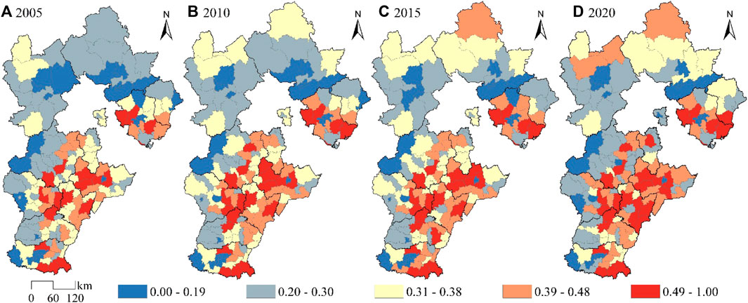
FIGURE 1. Spatio-temporal evolution pattern of cultivated land use supply transformation index.
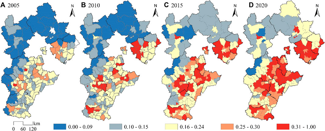
FIGURE 2. Spatio-temporal evolution pattern of cultivated land use demand transformation index.
During the research period, the transformation index of land utilization supply and demand in Hebei Province showed an upward trend. The greatest increase in the transformation index occurred between 2005 and 2010. Moreover, the standard deviation of the transformation index of land utilization supply and demand has been increasing year by year, indicating that the differences in land supply capacity among various districts and counties have been continuously expanding.
(1) The index of transformation in the utilization of cultivated land supply showed a growing trend from 2005 to 2010. The transformation index of cultivated land utilization and supply in Luanzhou, Leting, and Zunhua of Tangshan City increased rapidly. With the gradual improvement of cultivated land production conditions, the total agricultural production value and total grain yield increased. The region is relatively close to Beijing and Tianjin, with well-developed transportation conditions, which is conducive to the production, circulation, and sales of cultivated land crops. The junction of Hengshui City, Xingtai City, and Shijiazhuang City is a high-value area for the transformation index of cultivated land use and supply. The supply capacity of cultivated land in areas such as Jizhou and Fucheng in Hengshui City has improved rapidly. This area is located in the Hebei Plain area, with good water and thermal conditions for cultivation. The transformation index of cultivated land use and supply in areas adjacent to Hengshui City, such as Wuqiao and Nangong, has increased significantly.
(2) From 2010 to 2015, the transformation index of cultivated land utilization and supply in Chengde City grew at the fastest rate, with a significant increase in the supply capacity of cultivated land in areas such as Weichang, Fengning, Longhua, and Pingquan. The region is short of water resources, with little change in effective irrigation area, and a significant increase in the ecological supply capacity of cultivated land. The agglomeration degree of the transformation index of farmland utilization and supply in the western districts and counties of Handan City has increased, and the pattern of east-west differentiation is significant. From the perspective of the quantity supply of farmland, the proportion of slope farmland in the eastern mountainous areas far exceeds that in the western plains. There are many saline alkali lands in coastal areas such as Huanghua in the eastern part of Cangzhou City, making development difficult. The main crops such as corn in Hejian, Xianxian, and Cangxian in the eastern part have high yields, and the transformation of arable land utilization and supply refers to long-term high levels.
(3) The growth rate of the transformation index of arable land utilization and supply from 2015 to 2020 has slowed down, and the agglomeration of arable land supply capacity in the southeastern part of Hebei Province is relatively high. The grain planting area in Huanghua and Dongguang in Cangzhou has increased significantly, and the yield of arable land has been increased through planting salt alkali tolerant plants and soil improvement techniques. The ancient cities of Hengshui, such as Zaoqiang and Wuyi, have a large agricultural population, with rural residents mainly relying on agriculture for their income and strong ability to guarantee arable land. The natural conditions at the junction of Shijiazhuang and Hengshui are similar, and the supply capacity of arable land is strong. Baoding City, Shijiazhuang City, Xingtai City, and Handan City are located in the western Taihang Mountains, with high labor costs. The distribution of arable land in the mountainous areas is scattered, and the degree of fragmentation is low. The growth rate of the transformation index of arable land utilization and supply is relatively low.
During the research period, the transformation index of land utilization demand in Hebei Province exhibited significant growth. The eastern part of Hebei Province experienced a higher increase in the transformation index of land utilization demand. The most substantial increase in the transformation index occurred between 2010 and 2015. Compared to the transformation of land utilization supply, the transformation of land utilization demand is more influenced by policy adjustments and exhibits more pronounced agglomeration effects. The changes in land utilization demand within evaluation units are more drastic, while the external effects of land utilization demand between evaluation units are stronger.
(1) From 2005 to 2010, the transformation index of arable land use demand showed a relatively low range of changes, with some districts and counties experiencing significant growth in arable land use demand. Rural residents in Jinzhou, Gaocheng, and Xinji in the western part of Shijiazhuang City experienced significant income growth, while agricultural development also led to an increase in rural residents’ consumption levels, resulting in an increased demand for arable land for rural development. The increase in urbanization construction speed occupies the arable land space around the city, and the demand for the quantity of arable land resources increases. The primary and secondary industries in Fengnan, Fengrun, and Yutian in the western part of Tangshan City have developed rapidly, and the demand for rations, industrial grains, and feed has increased. The low demand for arable land utilization in districts and counties of Handan City has undergone significant changes, such as Wu’an City and Congtai District. During this period, the arable land area in Handan City continued to grow.
(2) The transformation index of cultivated land use demand from 2010 to 2015 showed significant differences: the population in the eastern part of Hebei Province flowed from rural areas to urban areas, and population mobility was a direct factor in the growth of cultivated land use demand. The demand for cultivated land increased faster in urban areas with higher population density and surrounding areas, such as Shijiazhuang and Baoding urban areas. Langfang City undertakes the population of Beijing and Tianjin, while Tangshan City undertakes some industries. The population and industries have increased the regional price level, and the economic demand for arable land has increased. The growth rate of the demand transformation index for arable land utilization in the northwest of Hebei Province is relatively low, and the growth rate is relatively fast. For example, in the municipal districts of Zhangjiakou City, Xuanhua, and Yuxian, there is unemployment while economic development, and the demand for employment protection for arable land is outstanding and perfect.
(3) The transformation index of land utilization demand in the eastern counties of Hebei Province from 2015 to 2020 has further improved, forming a significant high-value agglomeration zone from Tangshan to Shijiazhuang. This region is mostly plains and has well-developed transportation conditions in terms of location. There is a large income gap between urban and rural areas, requiring the guarantee of land resources to ensure social stability. The growth of the transformation index of land utilization demand in Xingtai City and Handan City is concentrated in the eastern region, such as Nong and Weixian. The agricultural mechan level in Botou, Cxian, and Hejian of Cangzhou City is relatively high, with large areas of rural settlements. The adaptability of agricultural labor and mechanization level is strong, and there is a higher demand for rural development based on land production.
To analyze the spatial evolution characteristics of land utilization supply and demand transformation, and to explore the development trends and factors influencing the spatial changes in land utilization transformation, a kernel density estimation model is selected. Formula (3) is used to calculate the kernel density of land utilization supply and demand transformation in Hebei Province. The natural break classification method is applied to classify the kernel density of land utilization supply and demand transformation into low-density, medium-density, and high-density areas. The analysis of the spatial patterns of land utilization supply and demand transformation is conducted by examining the area and spatial changes of the density zones. Please refer to Figure 3 and Figure 4 for the kernel density maps of land utilization supply and demand transformation in Hebei Province.
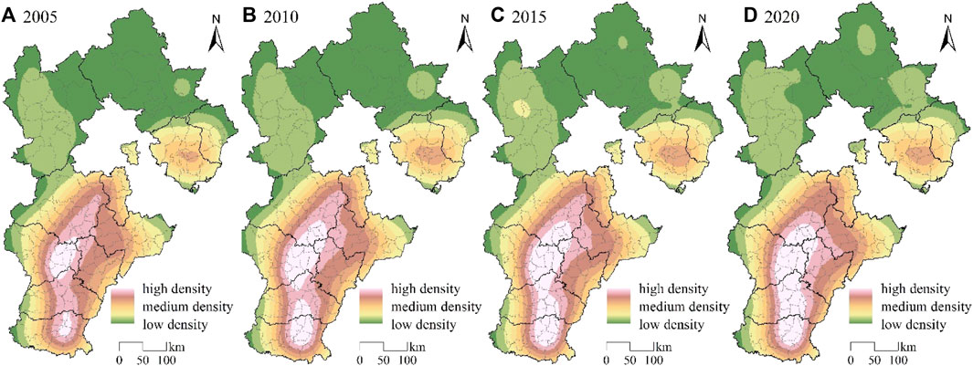
FIGURE 3. Kernel density estimation of cultivated land use supply transformation index.
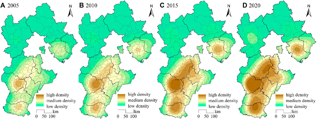
FIGURE 4. Kernel density estimation of cultivated land use demand transformation index.
During the research period, the overall distribution of the nuclear density of cultivated land use supply transformation was high in the south and low in the north. The center of the high-density area was in the eastern part of Shijiazhuang City, while the medium density area was mainly distributed at the edge of Tangshan City and the high-density area. Chengde City had the lowest nuclear density of cultivated land use supply transformation, followed by Zhangjiakou City.
(1) From 2005 to 2010, there was little change in the total area of high-density areas, with core areas such as the intersection of Shijiazhuang, Baoding, and Hengshui experiencing a growth in nuclear density. The area of high-density areas at the intersection of Handan and Xingtai in the south slightly expanded. The medium density area is widely distributed in Tangshan City, Cangzhou City, the western part of Baoding City, and the western part of Shijiazhuang City. The area has a wide distribution range, high environmental advantage, and potential improvement ability in arable land utilization and supply. The proportion of low-density areas is the largest, and the farming infrastructure in northern Hebei Province is weak, lacking irrigation water sources, making it suitable for the combined development of planting and animal husbandry.
(2) The improvement direction of the transformation index of arable land use and supply from 2010 to 2015 is mainly in the southeast, with relatively small changes in the number of high-density areas and counties in Xingtai City. Affected by the spillover effect of Shijiazhuang City in the north and Handan City in the south, the supply capacity of arable land use has been enhanced. The range of changes in medium density areas is relatively small, mainly distributed in transitional areas with significant changes in arable land supply capacity. The range of medium density areas has slightly decreased compared to the previous period, and some medium density areas have been transformed into high-density areas. The potential of arable land in this area is gradually developed, and agriculture and tourism are integrated in the western mountainous areas. The area of low-density areas in Chengde and Qinhuangdao cities expanded, and the supply capacity of arable land gradually stabilized during this period.
(3) The density area of the transformation index of cultivated land use and supply from 2015 to 2020 showed relatively small changes, while the area of high-density areas increased significantly compared to the initial stage of the study. In terms of space, it covers Shijiazhuang, Baoding, Hengshui, Cangzhou, Xingtai, and Handan cities. The soil texture of this area is suitable for cultivated land, and the terrain is flat, forming a belt shaped area with advantages in cultivated land use and supply. There are scattered expansion patches in the low-density area, and the transformation index of arable land utilization and supply in some districts and counties has increased. For example, the paddock in Chengde City has a significant advantage in the development of the aquaculture industry, with multiple pastures serving as an ecological barrier in the north. Sightseeing agriculture and characteristic agricultural product processing industry are gradually developing.
The overall distribution of cultivated land use demand transformation density areas is high in the south and low in the north. The southern high-density areas are constantly expanding with the urban area as the core, while the transformation index of cultivated land use demand in the northern low-density areas is gradually increasing. Overall, the change in the area of low-density areas is relatively small.
(1) From 2005 to 2010, the high-density areas had a relatively large circle area, and the radiation effect of the transformation of arable land use demand was relatively low. This indicates that the degree of dispersion of the transformation index of arable land use demand in districts and counties was high, and the degree of mutual influence was weak. During this period, the degree of large-scale utilization of arable land was low, with agricultural grain as the main demand for arable land and low level of agricultural mechanization. The medium density area in the eastern part of Baoding City has evolved into a high-density area, with a small and densely populated county area and a significant transformation in demand for arable land utilization. Low density areas are widely distributed in Zhangjiakou and Chengde cities, with significant differences from medium density areas.
(2) From 2010 to 2015, the area of high-density areas in the transformation of arable land use demand significantly expanded. The development of high-density areas was influenced by Beijing and Tianjin, with Shijiazhuang City as the core and expanding towards the northeast. The spillover effect of nuclear density in the eastern part of Shijiazhuang City, which has a high demand for arable land use, on the surrounding areas was significant. The tourism industry in Zhangjiakou urban area, Xuanhua, and Wanquan is developing in combination with agriculture and animal husbandry, transitioning from low density areas to medium density areas. The overall development direction is mainly towards the south, and the overall utilization level of arable land, forest land, and grassland is increasing.
(3) From 2015 to 2020, there was a significant expansion of high-density areas. The core high-density areas include the downtown area of Shijiazhuang, Xiong’an New Area, and economically developed counties, indicating a close connection between changes in land demand and economic development. The demand for cultivated land has shifted from agricultural product demand to the needs of social stability and rural development. The medium-density area in the southeast plain of Hebei Province gradually decreased during this period, mainly concentrated in the coastal cities of Cangzhou and Qinhuangdao. Qinhuangdao has witnessed rapid development in fisheries and tourism, and it has a relatively small total population in the region. The low-density areas in Zhangjiakou and Chengde transitioned into medium-density areas, and the expansion of demand is focused on the flat southern counties.
There are differences between the direction and speed of transformation of land utilization supply and demand in Hebei Province. A coupling coordination model is selected for analysis, and the coupling coordination degree of land utilization supply and demand transformation is calculated using Formula (6). The spatial correlation between the transformation of land utilization supply and demand in Hebei Province from 2005 to 2020 is explored. The lowest value of the coupling coordination degree of land utilization supply and demand in Hebei Province is 0.21, and the highest value is 0.79. Divided by intervals of 0.10, the coupling coordination degree of land utilization supply and demand is classified into six levels: moderate imbalance, mild imbalance, imminent imbalance, precarious coordination, primary coordination, and intermediate coordination, as shown in Figure 5.
(1) In 2005, the average coupling coordination degree of land utilization supply and demand transformation was 0.45, indicating mild imbalance. From the perspective of the coupling coordination degree, there is a strong correlation between land utilization supply and demand systems. The number of counties in imminent imbalance is the highest, with a total of 66 counties, accounting for 42.58% of the total. The second highest is precarious coordination, with a total of 40 counties, accounting for 25.80% of the total. The transformation index of land utilization supply and demand is low, and there are no counties in the intermediate coordination level. In terms of spatial distribution, primary coordination and intermediate coordination of land utilization supply and demand transformation are mainly concentrated in Shijiazhuang, Baoding, Cangzhou, and Tangshan. The level of land utilization supply and demand is relatively low, with most counties having a higher land utilization supply transformation index than demand. The coupling coordination degree of land utilization supply and demand transformation in Zhangjiakou and Chengde is lower than that in surrounding areas, with mainly mild and imminent imbalances, and a few counties with developed agriculture and animal husbandry are in moderate imbalance, such as Chicheng, Xinglong, and Kuancheng.
(2) In 2010, the average coupling coordination degree of land utilization supply and demand transformation was 0.48, with an overall improvement compared to 2005. During this period, the land production capacity increased, the transformation index of land utilization demand continued to grow, and the gap between land utilization supply and demand narrowed. From the perspective of the coupling coordination degree, there were 19 counties in mild imbalance, accounting for 12.26%, a decrease of 11 compared to 2005. The number of counties in imminent coordination remained unchanged. There were 46 counties in precarious coordination, accounting for 29.68%. In terms of spatial distribution, most counties in Hengshui and Handan were in precarious coordination. Primary coordination was mainly concentrated in Tangshan and Cangzhou, such as Fengrun, Yutian, Renqiu, Hejian, and Cangxian, with large administrative areas and rich resources. The transformation of land utilization supply and demand was synchronous. The climatic and natural conditions in Shijiazhuang and Baoding are similar, and there is a significant difference in the coupling coordination degree between eastern and western counties. Most eastern counties are in precarious coordination, while western counties are in imminent imbalance.
(3) In 2015, the average coupling coordination degree of land utilization supply and demand transformation was 0.52, transitioning from mild imbalance to precarious coordination. The growth rate of the transformation index of land utilization demand was faster than that of supply, indicating a relatively balanced index. From the perspective of the coupling coordination degree, the number of counties in imminent imbalance decreased to 59, accounting for 38.06%, and the number of counties in precarious coordination increased to 55, accounting for 35.48%. In terms of spatial distribution, a gradually improving northwest-southeast spatial pattern was formed. The mountainous areas in the northwest of Hebei Province have lower land utilization demand, and the improvement of land supply capacity is affected by labor migration. The southeast of Hebei Province has a rapid growth in land utilization demand, and the coupling coordination degree gradually develops towards intermediate coordination. The number of counties in moderate imbalance and mild imbalance decreased. Fuping, Xinglong, and Laiyuan counties changed from moderate imbalance to mild imbalance. These three areas have a small population density and limited agricultural labor resources, which restrict the speed of land utilization transformation in the region.
(4) In 2020, the average coupling coordination degree of land utilization supply and demand transformation was 0.54, further improving compared to 2015. The land protection policies in Hebei Province were continuously improved. From the perspective of the coupling coordination degree, there were no counties in moderate imbalance, and the number of counties in imminent imbalance and precarious coordination changed slightly, with 53 and 56 counties respectively. The number of counties in primary coordination changed significantly, increasing from 27 to 37, accounting for 23.87%. This indicates a gradual transformation in land utilization supply and demand towards high supply and high demand. In terms of spatial distribution, the coupling coordination degree of land utilization supply and demand steadily increased. The largest increase in the coupling coordination degree occurred between 2010 and 2015, transitioning from rapid rise to stable improvement. Combined with the index of land utilization supply and demand transformation, land utilization demand grew faster. The development differences in industries among the counties in Hebei Province led to heterogeneity in land demand. Soil conditions, water resources, and climate types should be fully considered to mitigate conflicts between land and other land types.
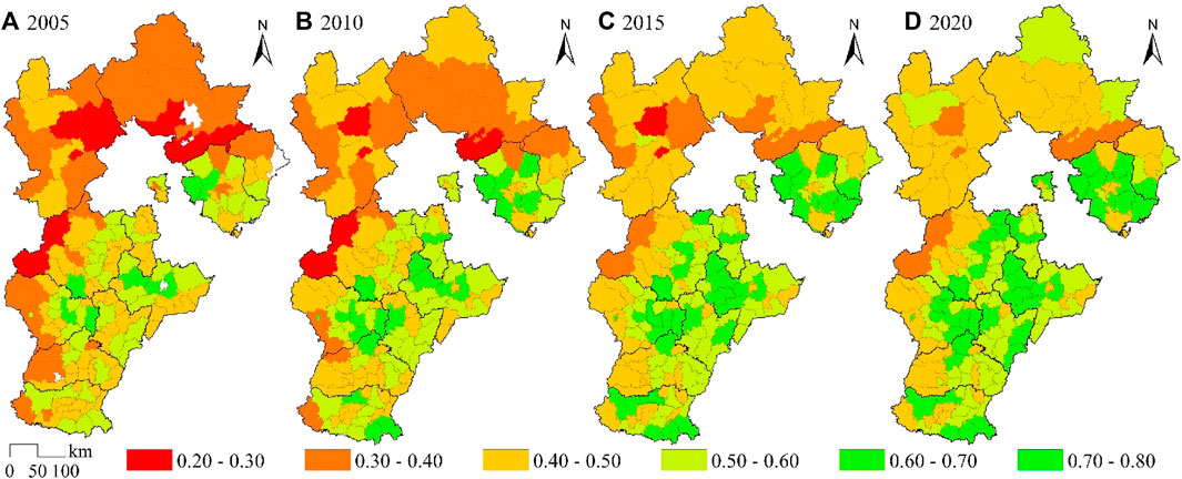
FIGURE 5. Coupling and coordination degree of cultivated land use supply and demand transformation.
The study selects three indicators from the perspective of natural environment: elevation, terrain undulation, and vegetation coverage. From the perspective of social economy, three indicators are selected: road mileage, urbanization rate, and total industrial output value. The factor detection function of geographic detectors is used to explore the influencing factors of the supply-demand transformation of farmland utilization. According to formula (7), the q value and significance of each influencing factor and the supply-demand transformation of farmland utilization are calculated, The higher the q value, the stronger the influence ability of this factor. The q value and significance of the transformation of arable land use supply and demand are shown in Table 3 and Table 4.
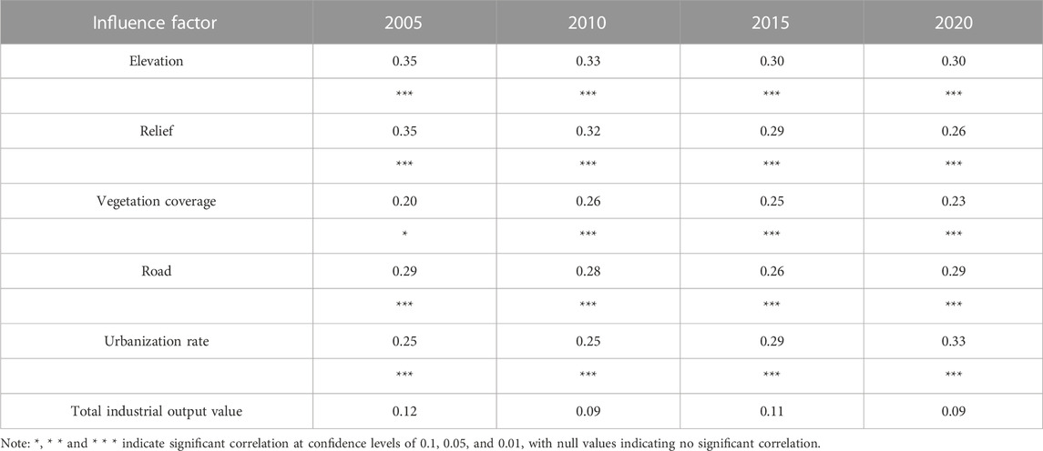
TABLE 3. Explanatory power and significance of influencing factors of cultivated land use supply transformation.
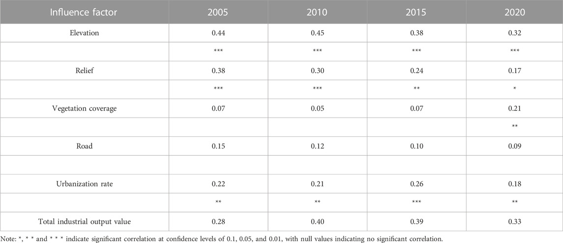
TABLE 4. Explanatory power and significance of influencing factors of cultivated land use demand transformation.
(2) From 2005 to 2020, the q-value of terrain fluctuation decreased from 0.35 to 0.26. Areas with lower terrain fluctuation were mainly distributed in the southeastern plain region and the northern plateau. Terrain fluctuation reflects the water, fertilizer, air, and thermal conditions of an area. The southeastern counties of Hebei Province had lower soil organic matter content. Improving soil physical and chemical properties is an effective measure to enhance the potential productivity of farmland. It is necessary to explore advantageous agricultural areas, utilize modern machinery in the agricultural production process, focus on the development of water-saving agriculture, and improve the quality of soil and water resources in order to promote the utilization and development of farmland and green areas (Zeng et al., 2022; Zeng, 2023).
(3) From 2005 to 2020, the q-value of vegetation coverage and the transformation of land utilization supply increased and then decreased, with significant enhancement after 2010. Regions with higher vegetation coverage were mostly areas with large forest and grassland areas. Vegetation coverage is strongly related to land utilization policies. The implementation of policies for converting cultivated land into forests and grasslands has effectively increased vegetation coverage, contributing to the construction of an ecological barrier around Beijing and Tianjin. Sloping farmland, which is difficult to develop and has low cultivation efficiency, should be planned for conversion into forests and grasslands. This will improve the regional ecological civilization level while also considering the rights and interests of farmers to enhance the social security supply capacity of cultivated land (Zhang P. et al., 2023).
(4) From 2005 to 2020, the urbanization rate was significantly correlated with the transformation of land utilization supply at a confidence level of 0.01. The q-value of the urbanization rate increased significantly after 2010, indicating that urbanization construction affects land supply capacity. Conflicts between urban construction land, residential land, and cultivated land have persisted for a long time. It is necessary to coordinate the utilization of construction land and cultivated land, reduce abandoned and fallow farmland in rural areas (Yu and Yin, 2023), and simultaneously enhance grain income and prioritize the cultivation of food crops to prevent non-food utilization of cultivated land and improve the food production capacity of cultivated land in order to ensure food security.
(5) From 2005 to 2020, the q-value of highway mileage initially decreased and then increased, and it was significantly correlated with the transformation of land utilization supply at a confidence level of 0.01, stabilizing at 0.29 overall. Highway mileage reflects the level of regional transportation development. Regional transportation costs and transportation time affect the prices of agricultural products. Improving transportation conditions and reducing transportation costs contribute to the circulation and further processing of agricultural products. Improving rural roads facilitates the circulation of agricultural products, the development of distinctive agricultural brands, and the enhancement of the added value of agricultural products.
Elevation and terrain undulation are the main natural factors affecting the transformation of arable land use and supply, and natural terrain is the primary factor limiting the transformation of arable land use and supply. The vegetation coverage gradually increased significantly after 2005. During the research period, there was a significant correlation between road mileage and urbanization rate and the transformation of arable land use supply at a confidence level of 0.01, while there was no significant correlation between total industrial output value and the transformation of arable land use supply. Analyzing the trend of q value changes in the transformation of arable land use supply from a factor perspective:
(1) From 2005 to 2015, the q value of elevation and arable land use supply transformation decreased from 0.35 to 0.30. With the development of modern agricultural technology, the impact of elevation gradually decreases, indicating that the degree of limitation of elevation on arable land use supply transformation has decreased. The supply of arable land can be improved through land consolidation, land reclamation, and other methods. Hebei Province has a high altitude difference, and the areas with higher elevations are mostly distributed in the Yanshan and Taihang Mountains. The terrain in this area is complex and not suitable for the use of modern agricultural machinery and large-scale utilization of arable land. The development and utilization of arable land are mostly based on households, and there are phenomena of abandonment and non grain cultivation of arable land. Therefore, it is necessary to strengthen land circulation and promote the rational utilization of arable land resources.
The driving factors for the transformation of arable land use demand include multiple levels such as food consumption, population mobility, land use conflicts, and economic development. Elevation, terrain undulation, urbanization rate, and total industrial output value are significantly correlated with the transformation of arable land use demand. Terrain conditions are the core factor limiting the transformation of demand for arable land use, causing differences in natural resources and economic development, thereby affecting the supply and demand level of arable land use in counties. Labor force is the core element of the agricultural industrial structure, indirectly affecting demand from the supply side.
(1) The correlation between elevation and the transformation of cultivated land use demand is strong. During the research period, the q value of elevation decreased from 0.44 to 0.32. Areas with higher elevations have greater difficulty in development and lower intensity of cultivated land use demand. The q value of terrain undulation decreases significantly, and the correlation with the transformation of arable land use demand is becoming weaker. It is the main limiting factor for the growth of arable land use demand at small scales such as urban areas. Regions with high terrain undulation have lower population agglomeration and density, lower demand for arable land resources, and flat terrain areas are suitable for urban construction and agricultural production. Urban construction and rural development require support from arable land resources, and the demand for arable land resources is high.
(2) The urbanization rate is significantly correlated with the transformation of farmland utilization demand, with the highest q value of 0.26 in 2015. The areas with higher urbanization rates are mostly municipal districts and surrounding areas. The population siphon effect is stronger in areas with higher urbanization rates. The increase in urbanization rates leads to a decrease in the proportion of agricultural population, and the transformation of labor forces leads to a scarcity of supply growth, indirectly affecting the demand for farmland utilization. The industrial structure of Hebei Province is in the process of transformation and development, gradually transitioning from being dominated by the secondary industry to being dominated by the tertiary industry. It is necessary to optimize the industrial structure, protect the ecological environment, and achieve the integrated development of agriculture and other industries.
(3) There is a positive correlation between the demand for farmland utilization and transportation conditions. The districts and counties with higher road mileage in Hebei Province are mostly located in Chengde City and Zhangjiakou City, which have larger administrative areas. The districts and counties with smaller administrative areas in the southeast of Hebei Province have lower road mileage, and the correlation between road mileage and farmland utilization demand is relatively low. The transportation advantage areas in Hebei Province are mostly located in Shijiazhuang, Tangshan, and Langfang. There is a high flow of people and industries in the Beijing Tianjin and surrounding areas. This area should pay attention to the circulation and complementarity of agricultural products, plan the use of arable land, and meet the needs of regional arable land use.
(4) The total industrial output value reflects the development level of the secondary industry in the region and is an important influencing factor for the transformation of farmland utilization demand. The q value first increases and then decreases, reaching a peak of 0.40 in 2010. The intensity of farmland utilization demand in industrial developed areas is high, with metal smelting as the main industry in Hebei Province. The proportion of agricultural and sideline food processing industry and food manufacturing industry is relatively low. While promoting agricultural industrialization, it should ensure the income of farmers. Promote the rational utilization of arable land resources in the process of urbanization and agricultural modernization, pay attention to the protection of the three in one system of arable land, broaden the channels for supplementing arable land, and improve the balance between supply and demand of arable land utilization.
During the research period, the supply and demand transformation index of arable land use in Hebei Province showed an upward trend. The agglomeration degree of the transformation index of cultivated land use supply in the southeast of Hebei Province is high, while the transformation index of cultivated land use supply in the northwest is relatively low. The transformation index of demand for arable land utilization has undergone significant changes. The demand for arable land in urban areas and surrounding areas with high population density has grown faster, and the demand for arable land has gradually transformed from agricultural products to social stability and rural development. At the same time as economic development, the ability to provide basic support for arable land has been enhanced. The overall distribution of the core density of supply and demand transformation for arable land use in Hebei Province is high in the southeast and low in the northwest. The improvement direction of the arable land use supply transformation index is mainly in the southeast, and the expansion trend of the density area of arable land use demand transformation is obvious. The dispersion degree of the arable land use demand transformation index between districts and counties is high.
The supply and demand system of cultivated land utilization in Hebei province has a strong correlation, and the coupling coordination of supply and demand of cultivated land utilization has steadily increased from 2005 to 2015. From 2015 to 2020, the coupling coordination has transformed from rapid growth to stable improvement, transitioning from imbalance to coordination at the provincial level, and gradually transforming toward high supply and high demand of cultivated land utilization. There is a significant spatial pattern differentiation in the coupling coordination of supply and demand for cultivated land utilization in Hebei province, with a overall spatial pattern of gradual improvement from northwest to southeast. The coupling coordination of the transformation of supply and demand of cultivated land utilization in the mountainous areas of the northwest is relatively low, and the improvement of land supply capacity is influenced by both labor migration and geographic environment. The southeast has seen rapid growth in demand for cultivated land utilization, and the level of coupling coordination has gradually increased.
The transformation of supply of cultivated land utilization in Hebei province is strongly correlated with the natural environment, and elevation and topographical fluctuation are the primary factors influencing the transformation of land supply. Highway mileage is significantly correlated with the transformation of land supply of cultivated land utilization, and improving transportation conditions and reducing transportation costs contribute to the development of the agricultural land industry. The transformation of demand for cultivated land utilization is closely related to social and economic development (Yin et al., 2022), and areas with flat terrain are suitable for urban construction and agricultural production. Urban construction and rural development require the support of land resources. Areas with higher urbanization rates have a greater population agglomeration, and the scarcity of supply stimulates the growth of the index of transformation of demand for cultivated land utilization. The total industrial output value is an important influencing factor for the transformation of demand for cultivated land utilization, and areas with developed industries such as Tangshan have a higher intensity of demand for cultivated land utilization. In the process of industrialization, urbanization, and agricultural modernization, attention should be paid to the protection of the three-dimensional cultivated land, expanding the ways of supplementary land, and improving the balance of supply and demand for cultivated land utilization.
Cultivated land utilization needs to ensure the current supply of grain production and meet the rigid demand for land utilization, while also adopting measures such as fallow rotation to enhance land productivity and achieve sustainable utilization of cultivated land. The southeastern part of Hebei province has flat terrain, and the level of contiguous cultivated land and mechanization should be improved. The support system for agricultural mechanization policies should be improved, and the comprehensive mechanization of the crop production process should be promoted to prevent non-food land utilization. The priority order of land utilization should be clarified to ensure the cultivated area for basic food crops. The northern part of Hebei province has a favorable natural environment, and the integration of agriculture and tourism should be promoted. Measures such as developing leisure agriculture, improving public facilities, and enhancing service levels should be taken to promote the integration of agriculture and tourism. In the western part of Hebei province, efforts should be made to build an ecological barrier around Beijing and Tianjin, carry out rural fallow trials, coordinate the arrangement of land retirement, afforestation, and grass planting, and optimize the ecological compensation mechanism for cultivated land.
The raw data supporting the conclusion of this article will be made available by the authors, without undue reservation.
LM: Conceptualization, Supervision, Writing–original draft, Writing–review and editing. FG: Software, Visualization, Writing–original draft, Writing–review and editing. HH: Methodology, Software, Validation, Writing–original draft, Writing–review and editing. YG: Formal Analysis, Investigation, Methodology, Writing–original draft, Writing–review and editing. LX: Formal Analysis, Funding acquisition, Project administration, Writing–original draft, Writing–review and editing. SY: Conceptualization, Methodology, Resources, Writing–original draft, Writing–review and editing.
The authors declare financial support was received for the research, authorship, and/or publication of this article. This research was funded by 2022 Annual Research Project on Development of Social Sciences in Hebei Province (20220303087); Research Project on Basic Scientific Research Funds of Provincial Universities in Hebei Province (KY2022100); Research Project on Humanities and Social Sciences in Universities in Hebei Province (SQ2023207).
The authors declare that the research was conducted in the absence of any commercial or financial relationships that could be construed as a potential conflict of interest.
All claims expressed in this article are solely those of the authors and do not necessarily represent those of their affiliated organizations, or those of the publisher, the editors and the reviewers. Any product that may be evaluated in this article, or claim that may be made by its manufacturer, is not guaranteed or endorsed by the publisher.
An, Y., Tan, X., Li, Y., Zhou, Z., Yu, H., and Ren, H. (2022). Study on the spatiotemporal evolution characteristics and influencing factors of cultivated land function in the Dongting Lake area. Geogr. Sci. 42 (7), 1272–1282.
Chen, L., Hao, J., Wang, F., Yin, Y., Gao, Y., Duan, W., et al. (2016). Research on carbon fixation function of cultivated land in the huanghuaihai plain based on carbon cycle. Resour. Sci. 38 (6).
Chen, L. (2022). The spatial scale characteristics and driving mechanisms of the transformation of cultivated land use function: an investigation of the jialing River Basin in sichuan province. Res. Soil Water Conservation 05, 327–335+342.
Du, G., Chai, L., and Li, Y. (2022). Theoretical analysis and research framework of farmland utilization system. Prog. Geogr. Sci. 2022.
Du, G., Guo, K., and Yu, F. (2021). Suggestions for the transformation and regulation of cultivated land utilization function in reclamation areas of heilongjiang province. Res. Agric. Mod. 42 (4), 589–599.
Fu, H., Liu, Y., Sun, H., and Zhou, G. (2020). Spatiotemporal characteristics and dynamic mechanism of cultivated land use transition in the Beijing-Tianjin-Hebei region. Prog. Geogr. Sci. 39 (12), 1985–1998. doi:10.18306/dlkxjz.2020.12.003
Gai, Z., Zhan, W., Wang, H., and Du, G. (2022). Research on the spatiotemporal differentiation characteristics and formation mechanism of carbon emissions from farmland utilization transformation. J. Agric. Mach. 07, 187–196.
Gu, J., and Zha, L. (2012). A study on the dynamic changes of crop carbon storage in the wanjiang urban belt. Resour. Environ. Yangtze River Basin 21 (12), 1507–1513.
Guo, J., Zhang, Y., Zhang, Z., Hou, L., and Zeng, W. (2023). Land use change and its driving mechanism in the mountainous and canyon areas of southeastern Tibet based on geographic detectors. J. China Agric. Univ. 28 (4), 210–226.
He, S. (2019). “Research on multifunctional evaluation and use zoning of cultivated land based on multisource information,” (Hangzhou, China: Zhejiang University). Doctoral dissertation.
Jiang, M., Li, Z., Li, J., and Liu, X. (2022). Detection and spatiotemporal characteristics of abrupt changes in farmland utilization transformation: a case study of Dongchuan District, Kunming City. Chin. Land Sci. 2022.
Jin, Y., and Wang, F. (2022). Analysis of the spatiotemporal evolution characteristics and influencing factors of farmland utilization transformation in the Pearl River Delta. Res. Soil Water Conservation 2022.
Kong, X., Wang, J. S., and Yang, H. (2021). Upregulation of lncRNA DARS-AS1 accelerates tumor malignancy in cervical cancer by activating cGMP-PKG pathway. J. Soc. Sci. Hunan Normal Univ. 50 (3), 1–11. doi:10.1002/jbt.22749
Kuang, B., Fan, B., and Lu, X. (2021). The spatiotemporal differentiation characteristics and influencing factors of green transformation efficiency in farmland utilization in China. Trans. Chin. Soc. Agric. Eng. 37 (21).
Li, Q. (2017). Research on the characteristics and mechanisms of farmland utilization transformation in the middle reaches of the Yangtze River. Wuhan: China University of Geosciences.
Long, H., Hua, D., and Wang, J. (2019). Research progress and prospects on the coupling of land use transformation and rural transformation development. ACTA Geogr. SIN. 74 (12).
Long, H., and Li, X. (2006). The Transformation of Cultivated Land and Land Consolidation in China: Research progress and framework. Prog. Phys. Geogr. 5, 67–76.
Lu, H., Hu, L., Zheng, W., Yao, S., and Qian, L. (2020). Impact of household land endowment and environmental cognition on the willingness to implement straw incorporation in China. J. Clean. Prod. 262, 121479. doi:10.1016/j.jclepro.2020.121479
Lu, H., Xie, H., Lv, T., and Yao, G. (2019). Determinants of cultivated land recuperation in ecologically damaged areas in China. Land Use Policy 81, 160–166. doi:10.1016/j.landusepol.2018.10.052
Lu, X., Wang, H., Tang, Y., and Jiang, X. (2021). A Study on the Spatial Spillover Effect of the Transformation of Cultivated Land Utilization on Farmers’ Income in Hubei Province. resour. environ. Yangtze River Basin 30 (7), 1757–1767.
Lv, T., Fu, S., Zhang, X., Wu, G., Hu, H., and Tian, J. (2022). Assessing cultivated land–use transition in the major grain-producing areas of China based on an integrated framework. Land 11 (10), 1622. doi:10.3390/land11101622
Ma, L., Xu, S., Guo, F., Xu, L., and Yin, S. (2022). Spatial differentiation and influencing factors of rural-area multi-functionality in Hebei province based on a spatial econometric model. Front. Environ. Sci. 10, 773259. doi:10.3389/fenvs.2022.773259
Niu, S., Fang, B., Cui, C., and Huang, S. (2020). Analysis of the spatiotemporal pattern and path of farmland utilization transformation from the perspective of rural revitalization - taking the Huaihai Economic Zone as an example. J. Nat. Resour. 35 (8), 1908–1925.
Song, H., and Xin, L. (2021). Research on the differentiation characteristics and influencing factors of cultivated land use intensity in China. Trans. Chin. Soc. Agric. Eng. 37 (16).
Song, X., and Li, X. (2019). Theoretical explanation and empirical study on the transformation of regional cultivated land utilization function. J. Geogr. 74 (5), 992–1010.
Song, X., Wu, X., and Ouyang, Z. (2014). Discussion on the research path of cultivated land transformation. Geogr. Res. 33 (3).
Sun, Y. (2018). A study on the coupling relationship between the transformation of cultivated land use and grain yield in shaanxi province. China’s Agric. Resour. zoning 39 (7), 14–20.
Tang, Y., Lu, X., and Zhang, X. (2021). Research on the impact and threshold effect of highway infrastructure construction on the transformation of cultivated land use. Chin. Land Sci. 35 (1), 59–68.
Wei, X., Lin, L., Luo, P., Wang, S., Yang, J., and Guan, J. (2022). Analysis of the spatiotemporal pattern and driving forces of multifunctional coupling and coordinated development of cultivated land. Trans. Chin. Soc. Agric. Eng. 38 (4).
Xie, S., Yin, G., Lou, Y., and Wei, W. (2022). Analysis of the “water drought differentiation” pattern and mechanism of cultivated land use in China from 1990 to 2020. Land Sci. China 06, 113–124.
Yang, L., Min, J., and Kong, X. (2018). The transformation of cultivated land in the three gorges reservoir area and its influencing factors. Resour. Dev. Mark. 34 (11), 1511–1519.
Yin, S., Wang, Y., and Xu, J. (2022). Developing a conceptual partner matching framework for digital green innovation of agricultural high-end equipment manufacturing system toward agriculture 5.0: a Novel Niche Field Model Combined with Fuzzy VIKOR. Front. Psychol. 13, 924109. doi:10.3389/fpsyg.2022.924109
Yin, Z., and Kang, Z. (2022). Advances in kernel density estimation supported by time geography. Prog. Geogr. Sci. 41 (01), 64–72. doi:10.18306/dlkxjz.2022.01.006
Yu, Y., and Yin, S. (2023). Incentive mechanism for the development of rural new energy industry: new energy enterprise–village collective linkages considering the quantum entanglement and benefit relationship. Int. J. Energy Res. 2023, 1–19. doi:10.1155/2023/1675858
Zeng, J., Chen, X., Cui, R., and Zhao, P. (2022). How does the enterprise green innovation ecosystem collaborative evolve? Evidence from China. J. Clean. Prod. 375, 134181. doi:10.1016/j.jclepro.2022.134181
Zeng, J. (2023). Exploring the influence of ecological relationship on knowledge interaction in green innovation cooperation. Environ. Sci. Pollut. Res. 2023 (30), 45369–45387. doi:10.1007/s11356-023-25436-4
Zhang, P., Lu, H., Geng, X., and Chen, Y. (2023b). How do outsourcing services affect agricultural eco-efficiency? Perspectives from farmland scale and technology substitution. J. Environ. Plan. Manag. 2023, 1–25. doi:10.1080/09640568.2023.2246170
Zhang, W., Zhang, Z., Dong, J., Zhang, H., Gao, F., and Gong, W. (2021). Analysis of the transformation and driving forces of cultivated land use function from a multiscale perspective - taking gansu province as an example. Geogr. Sci. 41 (5), 900–910.
Zhang, Y., Dai, Y., Chen, Y., Ke, X., and Yu, X. (2023a). The spatiotemporal evolution and driving factors of multifunctional coupling coordination of cultivated land in China. J. Agric. Eng. 35 (07), 244–249. doi:10.3760/cma.j.cn121430-20220815-00745
Keywords: transformation of land use, supply and demand, spatiotemporal evolution, influencing factors, Hebei Province
Citation: Ma L, Guo F, Hu H, Guo Y, Xu L and Yin S (2023) Analysis of temporal and spatial evolution characteristics and influencing factors of land use transformation in Hebei Province from the perspective of supply and demand. Front. Environ. Sci. 11:1294180. doi: 10.3389/fenvs.2023.1294180
Received: 15 September 2023; Accepted: 06 October 2023;
Published: 30 October 2023.
Edited by:
Hua Lu, Jiangxi University of Finance and Economics, ChinaReviewed by:
Jian Hou, Henan Agricultural University, ChinaCopyright © 2023 Ma, Guo, Hu, Guo, Xu and Yin. This is an open-access article distributed under the terms of the Creative Commons Attribution License (CC BY). The use, distribution or reproduction in other forums is permitted, provided the original author(s) and the copyright owner(s) are credited and that the original publication in this journal is cited, in accordance with accepted academic practice. No use, distribution or reproduction is permitted which does not comply with these terms.
*Correspondence: Lei Xu, eHVsZWkwOUAxNjMuY29t; Shi Yin, c2h5c2hpMDMxNEAxNjMuY29t
†ORCID: Shi Yin, https://orcid.org/0000-0001-6885-7412
Disclaimer: All claims expressed in this article are solely those of the authors and do not necessarily represent those of their affiliated organizations, or those of the publisher, the editors and the reviewers. Any product that may be evaluated in this article or claim that may be made by its manufacturer is not guaranteed or endorsed by the publisher.
Research integrity at Frontiers
Learn more about the work of our research integrity team to safeguard the quality of each article we publish.