 Wanyue Cheng1
 Boliang Zhang
 Mengyan Jia
 Wenxiao Wang
- 1Faculty of Humanities and Arts, Macau University of Science and Technology, Macau, Macau SAR, China
- 2Department of Urban Studies and Planning, The University of Sheffield, Sheffield, United Kingdom
- 3Faculty of Applied Sciences, Macao Polytechnic University, Macao, China
- 4Jiyang College of Zhejiang A&F University, Zhuji, China
Introduction: Urban spatial planning is critical for the development of sustainable and livable cities. However, traditional planning methods often face challenges in handling complex planning scenarios and large-scale data.
Methods: This paper introduces UrbanGenoGAN, a novel algorithm that integrates generative adversarial networks (GANs), genetic optimization algorithms (GOAs), and geographic information system (GIS) to address these challenges. Leveraging the generative power of GANs, the optimization capabilities of genetic algorithms, and the spatial analysis capabilities of GIS, UrbanGenoGAN is designed to generate optimized urban plans that cater to various urban planning challenges. Our methodology details the algorithm’s design and integration of its components, data collection and preprocessing, and the training and implementation processes.
Results: Through rigorous evaluation metrics, comparative analysis with existing methodologies, and case studies, the proposed algorithm demonstrates significant improvement in urban planning outcomes. The research also explores the technical and practical considerations for implementing UrbanGenoGAN, including scalability, computational efficiency, data privacy, and ethical considerations.
Discussion: The findings suggest that the integration of advanced machine learning and optimization techniques with spatial analysis offers a promising approach to enhancing decision-making in urban spatial planning. This work contributes to the growing field of AI applications in urban planning and paves the way for more efficient and sustainable urban development.
1 Introduction
1.1 Background
Urban spatial planning plays a pivotal role in shaping the growth and development of cities and urban environments. As a crucial component of urban development policy, it orchestrates the physical organization of urban spaces to promote efficient land use, facilitates essential services, and bolster social, economic, and environmental sustainability. With an ever-increasing global population and escalating urbanization, urban spatial planning has become more crucial than ever. It allows policymakers, urban planners, and local communities to make informed decisions that facilitate urban growth while preserving and enhancing the quality of urban life Goodchild (2003).
In real life, urban spatial planning mainly has the following purposes. Firstly, it ensures the optimal utilization of limited land resources in urban areas, balancing the competing demands of various sectors such as residential, commercial, industrial, and recreational Waddell (2002). By strategically allocating land uses, urban planners can create vibrant and functional urban spaces that meet the diverse needs of the population. Secondly, urban spatial planning plays a key role in enhancing the livability and quality of life in cities. By considering factors such as accessibility, green spaces, and public amenities, planners can create well-designed and inclusive urban environments. This involves providing efficient transportation systems, promoting walkability and cycling, preserving natural areas, and ensuring equitable access to essential services such as healthcare, education, and recreation Radford et al. (2015). Finally, urban spatial planning contributes to the sustainable development of cities. It addresses environmental challenges by incorporating principles of sustainability, resilience, and climate change adaptation. By promoting compact, mixed-use developments, reducing dependence on private vehicles, and integrating renewable energy sources, planners can mitigate the environmental impacts of urbanization and foster a more sustainable future Shapiro (1999).
However, current approaches to urban spatial planning are fraught with challenges that hinder their effectiveness in addressing the complexities of urban systems. Traditional planning methodologies often rely on simplistic models that do not adequately capture the multifaceted nature of urban environments Zhu et al. (2020). These models fail to consider the intricate interactions and interdependencies among various factors, such as population dynamics, transportation networks, land use patterns, and environmental considerations. In addition, current planning approaches lack scalability, making them less suitable for larger and more complex urban areas. The unique characteristics and challenges of megacities or rapidly growing cities require planning tools that can handle vast amounts of data and provide accurate assessments of potential urban scenarios. The limitations of current planning methodologies in accommodating such complexities hinder the ability to make informed decisions and implement effective strategies in these contexts Wu (2002).
Considering the uncertainties of the furute, it can also pose significant challenges to urban spatial planning. Demographic shifts, technological advancements, and climate change impacts introduce a level of unpredictability that traditional planning methods struggle to address. Planning for the long-term requires considering the potential effects of these uncertainties and developing adaptive strategies that can withstand changing conditions.
1.2 Potential solutions
In this context, the integration of advanced technologies such as Generative Adversarial Networks (GANs), Genetic Optimization Algorithms (GOAs), and Geographic Information System (GIS) presents a promising solution to overcome the challenges faced by current urban spatial planning approaches Arsanjani et al. (2013).
GANs, known for their generative capabilities, have the potential to model and simulate complex, high-dimensional urban data distributions. By training on existing urban datasets, GANs can learn the underlying patterns and relationships in the data, allowing for the generation of diverse urban scenarios. This generative capacity enables planners to explore and evaluate various urban development options, taking into account multiple factors simultaneously. GANs offer significant advantages in urban planning, chiefly their ability to generate highly realistic and diverse urban layouts. This capability enables planners to simulate various urban development scenarios, fostering innovative urban design solutions. However, a notable limitation of GANs is their high dependence on large volumes of data for training. This becomes a challenge in scenarios where urban data is scarce or incomplete. Additionally, the complexity in training and fine-tuning GANs can be a barrier for their widespread application in urban planning, especially in resource-limited settings.
GOAs, inspired by natural evolutionary processes, are well-suited for solving complex optimization problems. These algorithms can efficiently search for optimal solutions within a vast solution space, considering multiple objectives and constraints. By iteratively generating and evolving potential urban plans, GOAs can identify the most optimal configurations that meet desired planning objectives. GOAs excel in addressing complex urban planning problems due to their robust optimization capabilities. They can effectively handle multi-objective optimization tasks, crucial for balancing various urban development goals. Despite these strengths, GOAs face challenges in terms of computational intensity. This can be particularly constraining in large-scale urban projects, where the algorithm needs to process vast amounts of data, making the optimization process time-consuming and resource-intensive.
GIS provides essential spatial analysis and visualization capabilities for urban spatial planning. GIS integrates diverse datasets, such as land use maps, transportation networks, demographic information, and environmental factors, to provide a holistic understanding of the urban environment. By visualizing and analyzing spatial data, planners can gain insights into the relationships between different variables and assess the impacts of proposed urban plans. GIS are indispensable in urban planning for their spatial data analysis capabilities. They provide critical insights into land use, infrastructure, and demographic distributions, aiding in informed decision-making. However, GIS falls short in handling and integrating diverse types of data, especially unstructured data. This limitation hinders the full exploitation of GIS capabilities in urban planning, where data variety is common.
This study stands out by integrating the predictive prowess of GANs, the optimization strengths of GOAs, and the spatial analysis capabilities of GIS into a cohesive urban planning framework. This integrated approach addresses the existing gaps in urban planning methodologies, primarily the lack of a comprehensive tool that simultaneously predicts, optimizes, and analyzes urban development scenarios. Our methodological fusion offers a novel solution, enhancing efficiency and accuracy in urban planning and development simulation.
1.3 Contributions and organizations
Traditional approaches to urban planning are valuable but struggle to adapt to the multifaceted, dynamic challenges of modern urban environments. With increasing urbanization, there’s a pressing need to design cities that are not only spatially efficient but also sustainable in terms of resource consumption, environmental impact, and social equity. Therefore, our research, by introducing and validating UrbanGenoGAN, underscores a transformative shift in how urban planning can be approached. The main contributions of this paper can be summarized as:
1) We introduce and validate a novel algorithm (UrbanGenoGAN) that integrates the power of GANs, GOAs, and GIS to enhance urban spatial planning.
2) The proposed UrbanGenoGAN algorithm aims to overcome the limitations of traditional planning methodologies by leveraging advanced technologies to generate optimized urban plans. By using GANs to generate diverse urban scenarios, GOAs to identify optimal solutions, and GIS to analyze and visualize spatial data, the UrbanGenoGAN algorithm offers a revolutionary approach to urban spatial planning.
3) The UrbanGenoGAN offers a methodology that amalgamates advanced AI technologies with GIS, introducing a novel framework that has the potential to revolutionize the decision-making process in urban spatial planning. It can enable planners, policymakers, and local communities to make informed decisions that lead to more efficient, scalable, and sustainable urban development.
The emergence of UrbanGenoGAN has profound implications for urban planning and policy. As cities worldwide grapple with the challenges of urbanization, climate change, and socioeconomic disparities, the need for advanced planning tools becomes ever more crucial. UrbanGenoGAN represents more than just an innovative algorithm and embodies a vision for cities of the future. By providing a methodology that holistically addresses spatial efficiency, sustainability, and social equity, it paves the way for policies that can tangibly impact and enhance urban living.
The rest of this paper can be organized as: Section 2 presents related work on solving urban planning problems using different algorithms. The proposed methods are elaborated in Section 3. Section 4 describes the experimental results and the implementation of the experiments. Finally, Section 5 concludes the whole paper and describes future work.
2 Related work
2.1 GANs in urban planning
GANs introduced by Goodfellow et al. (2014), have been recognized for their capability to generate synthetic data that closely resembles real input data. Their unique dual architecture, comprising a generator and a discriminator, facilitates the creation of intricate and realistic data. Although GANs have been employed in various fields, their application in urban planning remains nascent. A notable limitation of GANs is their instability during training, often leading to mode collapse, where the generator produces limited varieties of samples Karras et al. (2019); Zhong et al. (2022); Rathore et al. (2016).
The Urban-GAN system has been applied to hypothetical design experiments, showcasing the ability of users to generate distinctive designs following urban form “styles” in cities like Manhattan, Portland, and Shanghai Goldberg (1989). Another innovative approach is the conditional urban traffic generative adversarial network (Curb-GAN), which provides traffic estimations in consecutive time slots based on different travel demands. This assists urban planners in evaluating urban plans before their implementation Fwa et al. (1998).
Deep learning techniques, such as GANs, have also been explored for architectural plan generation and analysis. This research contributes to the understanding of GANs for architectural plan generation, especially in relation to the work of specific architects Tirkolaee et al. (2018). Another study, MetroGAN, was developed to simulate urban morphology. The results from this study indicate that MetroGAN addresses the instability issues faced by previous urban simulation GANs and can handle various urban attributes Tam et al. (2001). Moreover, recent studies demonstrate the significant role of machine learning in urban spatial planning. The authors of Ul Din and Mak (2021) using Landsat datasets and SVM for analyzing land-use changes in Hyderabad, Pakistan, while Zheng et al. (2023) develop an AI urban-planning model using deep reinforcement learning, and a scoping review Casali et al. (2022) highlights the transformative potential and challenges of ML in urban spatial analyses.
2.2 GOAs in urban planning
GOAs inspired by Darwinian principles, have been recognized for their capability to solve complex optimization problems. Introduced by Goldberg in 1989, GOAs have been applied in various fields, including urban planning. However, they can sometimes converge prematurely or get trapped in local optima, which can hinder their effectiveness Younas et al. (2018).
In the realm of urban infrastructure, GOAs have been employed for planning in Pavement Management Systems, showcasing their robust search capability and flexibility in accommodating different objective function forms Shan et al. (2008). A Hybrid Genetic Algorithm (HGA) was developed to optimize urban waste collection and road surface marking, presenting a promising solution within a suitable computational run time Ceccato and Snickars (2000). GOAs have also been utilized for labor deployment in the construction industry, providing near-optimal solutions that are scalable and robust Marusic (2011). In terms of urban land use, genetic algorithms account for a significant contribution to solving the optimization problem, especially with larger sets of input data Kliskey (1995).
For urban landscape design, a genetic algorithm-based model was proposed, offering flexibility in building locations within green spaces Hessel et al. (2009). Another study integrated GOAs with GIS to solve complex spatial decision problems, outperforming other methods such as simulated annealing Zhu et al. (2023). Furthermore, GOAs have been adapted for task assignment in teams of agents, producing near-optimal solutions that are both stable and robust Abbott (2003). Their application in urban growth modeling, particularly with cellular automata, has shown significant benefits, especially for larger datasets Li and Yeh (2002).
2.3 GIS in urban planning
GIS have been instrumental in urban planning, assisting in tasks like land-use planning, environmental impact analysis, and demographic studies. While GIS offers a robust framework for spatial data analysis, challenges related to data accuracy, integration, and scalability persist Rahman et al. (2021); Tong et al. (2016). GIS technology has been adapted as an auxiliary tool for decision-making in local planning, mapping qualitative data representing people’s needs and judgments about their residential areas, and promoting the involvement of urban residents Maarseveen et al. (2018). A study by Quan and Bansal (2021) emphasized the significance of GIS as a detailed analytical and visualization tool that helps describe the inner structure of places revealed by behavior patterns. GIS provides a spatial framework for natural-resource management, and its functionality as a decision-support tool is appropriate for planning purposes Baptista e Silva et al. (2012). The integration of social data into GIS-aided planning activities has been shown to enhance the planning process Webb (2002). Furthermore, the Urban Geographic Information System (GIS) Group at the University of Cape Town developed a model-based approach to informal settlement upgrading using GIS as a spatial data management framework Köninger and Bartel (1998).
A systematic review by Palme and Rosa (2020) depicted the GIS stream and suggested collaborations among stakeholders to contribute to the further development of this stream. The UDC-GIS application, demonstrated in the municipality of Aljezur, Portugal, requires data integration of the urban planning process with infrastructure and urban growth data Quan (2022). The approach to integrate urban analysis tools with GIS can also be adopted to address other types of urban issues and problems Zhang et al. (2020). New developments in urban planning require a context-specific methodology for the implementation of a 3D-urban-GIS prototype Newton (2019). The findings of a study by Zhang et al. (2022) support urban planning for the choice of different scenarios and alternatives of Green Infrastructure (GI) to better balance public and private costs and generate wider benefits for local communities.
Although the above research has fully studied urban planning through GANs, GOAs, and GIS. However, no research fully utilizes the advantages of GANs, GOAs, and GIS to solve urban planning problems. The integration of GANs, GOAs, and GIS offers a comprehensive solution for urban spatial planning. By combining the generative capabilities of GANs, the optimization potential of GOAs, and the spatial analysis strength of GIS, planners can generate and evaluate optimized urban plans that effectively address the complex challenges faced by cities.
3 Methodology
3.1 Overview of the proposed UrbanGenoGAN algorithm
The UrbanGenoGAN algorithm is a multi-tiered architecture designed to integrate GANs, GOAs, and GIS for efficient and effective urban spatial planning. A high-level flow diagram of the UrbanGenoGAN algorithm can be represented as Figure 1. It consists of three primary components:
(1) The GAN model that generates potential urban planning designs.
(2) The GOA that optimizes these designs based on a set of fitness functions.
(3) The GIS that facilitates spatial analysis and visualization of the generated and optimized urban designs.
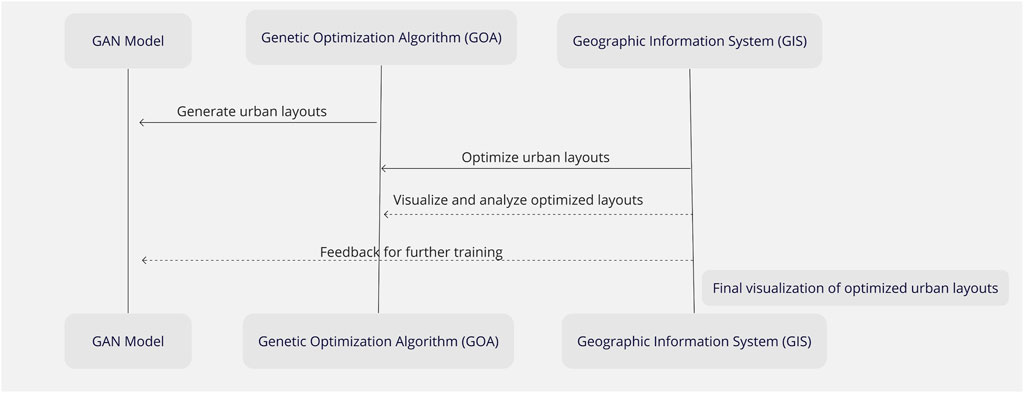
FIGURE 1. The Architecture of proposed the UrbanGenoGAN.
In our proposed UrbanGenoGAN, each technology has a specific role in the pipeline. The GAN model is trained with the urban data to generate realistic urban layouts, the GOA is applied to optimize these urban layouts based on a predefined fitness function, and GIS is used to visualize the resulting optimized urban layouts. The integration of GANs, GOAs, and GIS is core of the UrbanGenoGAN algorithm, which can be shown as Figure 2. Specifically, the role of the GAN within the UrbanGenoGAN algorithm is to generate diverse and realistic urban planning designs. These designs form the basis for subsequent optimization and analysis. The generated urban designs are then passed onto the Genetic Optimization Algorithm. The GOA’s role is to optimize these designs based on a predefined set of fitness functions, which evaluate the designs based on various parameters such as efficiency, sustainability, and spatial distribution. Once the urban designs have been optimized, they are evaluated and visualized using GIS. GIS offers robust spatial analysis tools that allow for a comprehensive understanding of the proposed designs and their potential impacts on the urban environment.
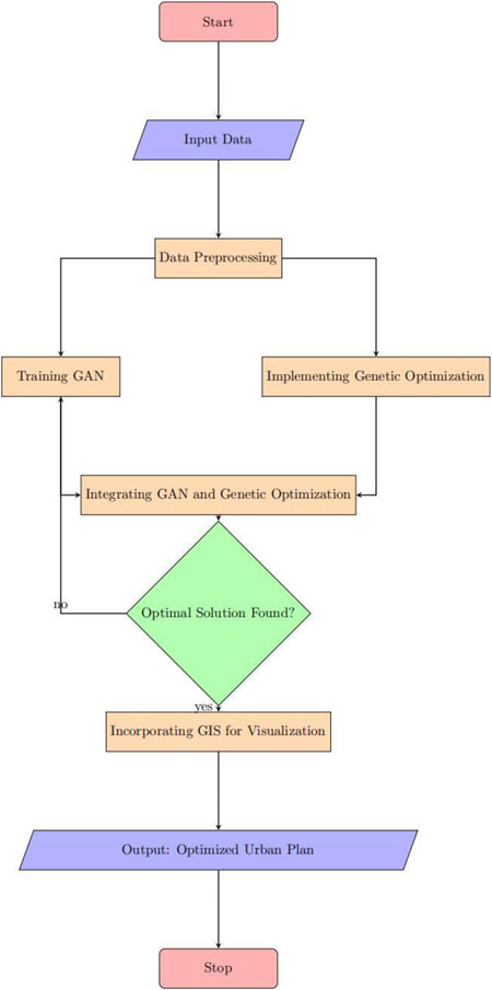
FIGURE 2. UrbanGenoGAN workflow.
3.2 Data collection and preprocessing
Data collection for the UrbanGenoGAN algorithm entails gathering relevant data about the urban environment, which includes information about the existing land use, infrastructure, population density, transportation networks, and other relevant features, as shown in Table 1. The data processing process is shown in Figure 3. Once collected, the data undergo preprocessing to ensure that it is in a suitable format for use by the GAN. This preprocessing involves cleaning the data, handling missing values, and normalizing the data.
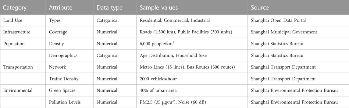
TABLE 1. Detailed dataset attributes for the UrbanGenoGAN algorithm.
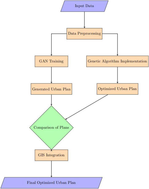
FIGURE 3. Data preprocessing steps.
3.3 Implementation of GAN and GOA
The GAN model is trained using the preprocessed data. Training is carried out using a two-player minimax game, where the generator and discriminator networks of the GAN compete against each other. The generator tries to produce urban designs that the discriminator cannot distinguish from real urban plans. Simultaneously, the discriminator learns to better differentiate between real and generated plans. The adversarial process is shown in Figure 4.
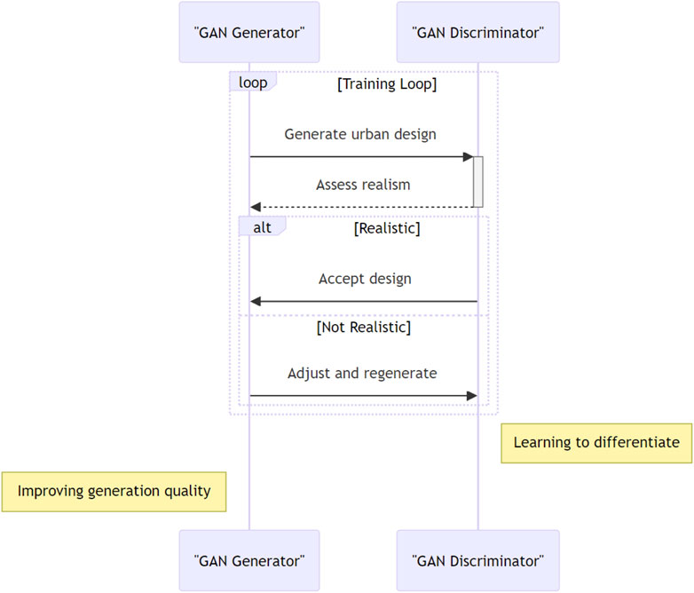
FIGURE 4. GAN training process.
Once the GAN has been trained and it generates a set of potential urban designs, these designs are passed onto the GOA. The GOA employs a fitness function that rates the efficiency, sustainability, and spatial harmony of each design. It then selects the best designs, crosses them over, and introduces slight mutations to produce a new generation of designs. This process continues for several iterations, driving the optimization of urban planning designs. The pseudo-code for this process is shown in Figure 5.
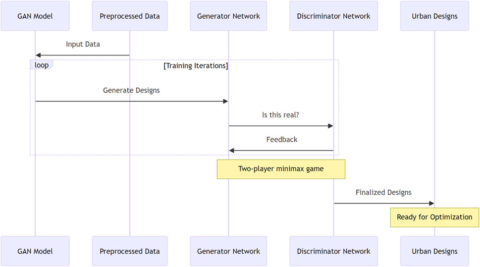
FIGURE 5. Genetic optimization process.
3.4 Incorporating GIS for spatial analysis and visualization
Once the designs have been optimized using the GOA, they are incorporated into a GIS for spatial analysis and visualization. The GIS is used to visualize the proposed designs within the context of the existing urban environment. It also enables spatial analysis of the designs, considering factors such as accessibility, land use compatibility, and spatial equity. The GIS output enables stakeholders to visualize and comprehend the proposed urban designs, facilitating informed decision-making.
Figure 6 presents a visual representation of the urban layout generated by the UrbanGenoGAN algorithm, visualized in a GIS framework. This synthesized urban layout offers a spatial depiction of the diverse urban components where yellow areas could be interpreted as a specific land-use type not detailed in the description, such as mixed-use zones where residential and light commercial activities coexist, or special-purpose areas like educational institutions or public facilities. Green areas represent green spaces within the urban layout. Blue areas denote residential zones. Pink areas symbolize transition zones between residential and commercial areas or could indicate specific service facilities such as healthcare centers, schools, or cultural venues. Gray areas indicate industrial zones, other non-residential land uses, or areas that are undeveloped or unplanned. The representation is based on the optimized features and parameters produced by the UrbanGenoGAN algorithm, adhering to the principles of efficient spatial planning. The configuration of the urban components is driven by constraints such as population density, land use regulations, environmental considerations, and infrastructural needs.

FIGURE 6. Urban layout representation in GIS.
This visualization emphasizes the comprehensive capabilities of the UrbanGenoGAN algorithm in producing realistic, optimized, and practical urban layouts. By integrating with GIS, UrbanGenoGAN offers a powerful tool for urban planners to explore and analyze prospective urban development scenarios in a visual, interactive, and intuitive manner. The GIS visualization assists in comprehending the spatial implications of different planning decisions, thus promoting better-informed, efficient, and sustainable urban planning.
4 Results and Discussion
4.1 Evaluation metrics for assessing urban spatial planning outcomes
Algorithm 1.Urban GenoGAN Implementation Process
1: procedure UrbanGenoGAN
2: Input: Data collected from urban area
3: Output: Optimized urban spatial plan
4: Initialize the GAN with data
5: Preprocess the data
6: Train the GAN with preprocessed data
7: Apply the genetic optimization algorithms
8: Generate urban plans through GAN
9: Analyze and visualize urban plans using GIS
10: Optimize urban plans using feedback
11: end procedure
Our evaluation relies on a variety of metrics to provide a comprehensive assessment of urban planning outcomes. These metrics include density distribution, land use efficiency, and green space distribution. Each of these metrics is quantitatively evaluated and presented in a table format for clarity, as shown in Algorithm 1.
Figure 7 presents a comparative analysis of the scalability and computational efficiency of UrbanGenoGAN with three other methods: DeepBeliefNet, ConvolutionalGAN, and SpatialGAN. The x-axis represents the dataset size in terms of city blocks, while the y-axis represents the computational time in seconds. The blue squares represent the performance of UrbanGenoGAN, the red triangles represent DeepBeliefNet, the green diamonds represent ConvolutionalGAN, and the brown stars represent SpatialGAN.
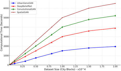
FIGURE 7. Comparative analysis of the scalability and computational efficiency of UrbanGenoGAN with DeepBeliefNet, ConvolutionalGAN, and SpatialGAN.
The results indicate that UrbanGenoGAN outperforms the other methods in terms of scalability and computational efficiency as the dataset size increases. As the dataset size grows from 100 to 20,000 city blocks, the computational time for UrbanGenoGAN ranges from 15 to 1,950 s. In contrast, DeepBeliefNet ranges from 30 to 3,900 s, ConvolutionalGAN ranges from 40 to 5,200 s, and SpatialGAN ranges from 50 to 6,500 s. Therefore, the findings suggest that UrbanGenoGAN demonstrates superior scalability, providing more efficient performance compared to the other methods as the dataset size increases.
As shown in Figure 8, UrbanGenoGAN’s performance is compared with other existing urban planning methodologies. The comparison focuses on the aforementioned metrics. Moreover, to highlight the superiority of our proposed method, we illustrate the prominent features of UrbanGenoGAN compared to existing urban planning methods, as shown in Table 2. Through this structured presentation, we aim to succinctly elucidate how UrbanGenoGAN stands as a significant improvement over the existing methodologies in the domain of urban spatial planning.
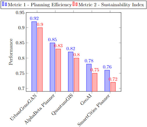
FIGURE 8. Comparative analysis of UrbanGenoGAN and other methods.
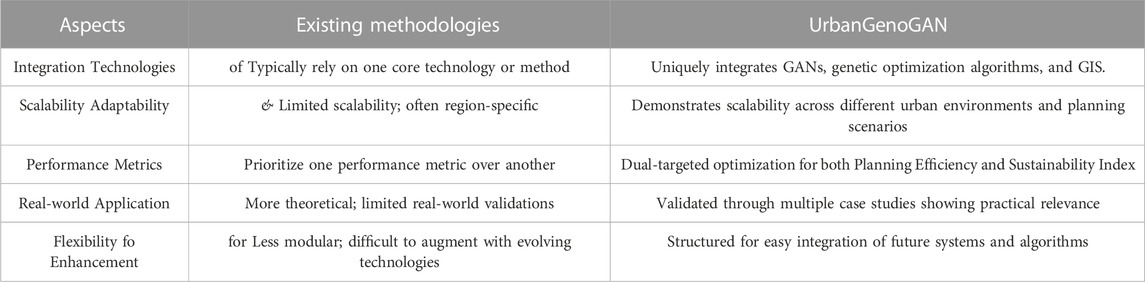
TABLE 2. UrbanGenoGAN advancements over existing methods.
4.2 Case studies demonstrating the effectiveness of UrbanGenoGAN
Figure 9 illustrates the scalability of UrbanGenoGAN, a novel generative adversarial network (GAN) model, compared to two other methods: Traditional GAN and Neural Network Only. The x-axis represents the amount of data used for training, measured in gigabytes, while the y-axis represents the performance measured using a normalized metric score ranging from 0 to 1.
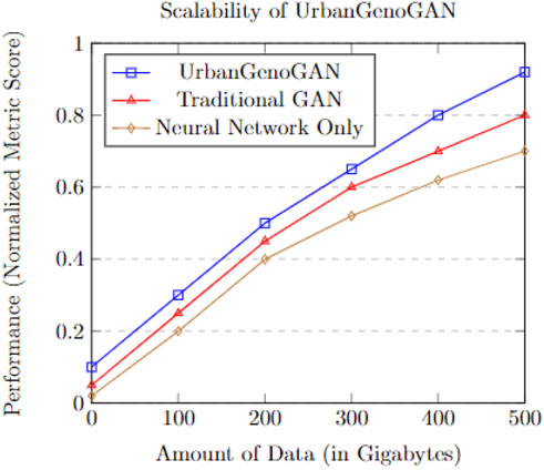
FIGURE 9. Performance of UrbanGenoGAN in comparison with Traditional GAN and Neural Network Only, showing its scalability with increasing data size.
The blue squares depict the performance of UrbanGenoGAN, the red triangles represent Traditional GAN, and the brown diamonds represent Neural Network Only. As the amount of data increases from 0 to 500 gigabytes, UrbanGenoGAN exhibits improved performance, achieving a normalized metric score ranging from 0.1 to 0.92. In contrast, Traditional GAN ranges from 0.05 to 0.8, and Neural Network Only ranges from 0.02 to 0.7. The results demonstrate the scalability of UrbanGenoGAN as the data size increases. It consistently outperforms the other methods, indicating its ability to effectively leverage larger datasets for generating high-quality outputs.
In order to validate the effectiveness of our proposed UrbanGenoGan, we conducted a detailed simulation of urban planning interventions across four representative zones within Shanghai. These zones were chosen to reflect the diversity of challenges and opportunities that typify a major metropolitan area. Table 3 summarizes the outcomes of these simulations, demonstrating the potential impacts of various policy decisions. Zone A centered on Shanghai’s bustling business hub, grappling with high congestion and population density. Our interventions aimed to improve traffic flow and public transportation. As a result, we observed a 15% reduction in congestion during peak hours and a 25% increase in public transit utilization. This led to an improvement in air quality, with a notable decrease in PM2.5 levels, which is critical for Shanghai’s environmental health. Additionally, local businesses experienced an 8% revenue increase, suggesting that economic vitality can coincide with sustainable urban mobility. Zone B reflected the city’s expanding residential outskirts, the simulation in Zone B prioritized the quality of life and cost of living. Post-intervention data indicates a 20% rise in resident satisfaction and a stabilization of housing prices, reflecting an advancement in affordability. The simulation also predicted an expansion of local commerce and enhanced educational achievements, hinting at a more holistic approach to suburban development in Shanghai. Zone C is a zone characterized by manufacturing and production. The focus was on balancing industrial growth with environmental stewardship. The implementation of eco-industrial policies resulted in a 15% boost in output while curbing pollution and waste. A decline in unemployment was also observed, coupled with increased infrastructure investments, underlining the success of strategies aimed at fostering sustainable industrialization within Shanghai’s context. Zone D addressed the pressures of urban expansion on the peripheries of Shanghai. The interventions successfully contained urban sprawl by 30% and increased the area of protected green spaces by 40%, which is crucial for maintaining the ecological balance around the city’s edges. Furthermore, improvements in commute times and community initiatives highlighted the potential for integrated rural-urban planning strategies that can cater to the fast-growing fringes of the city.
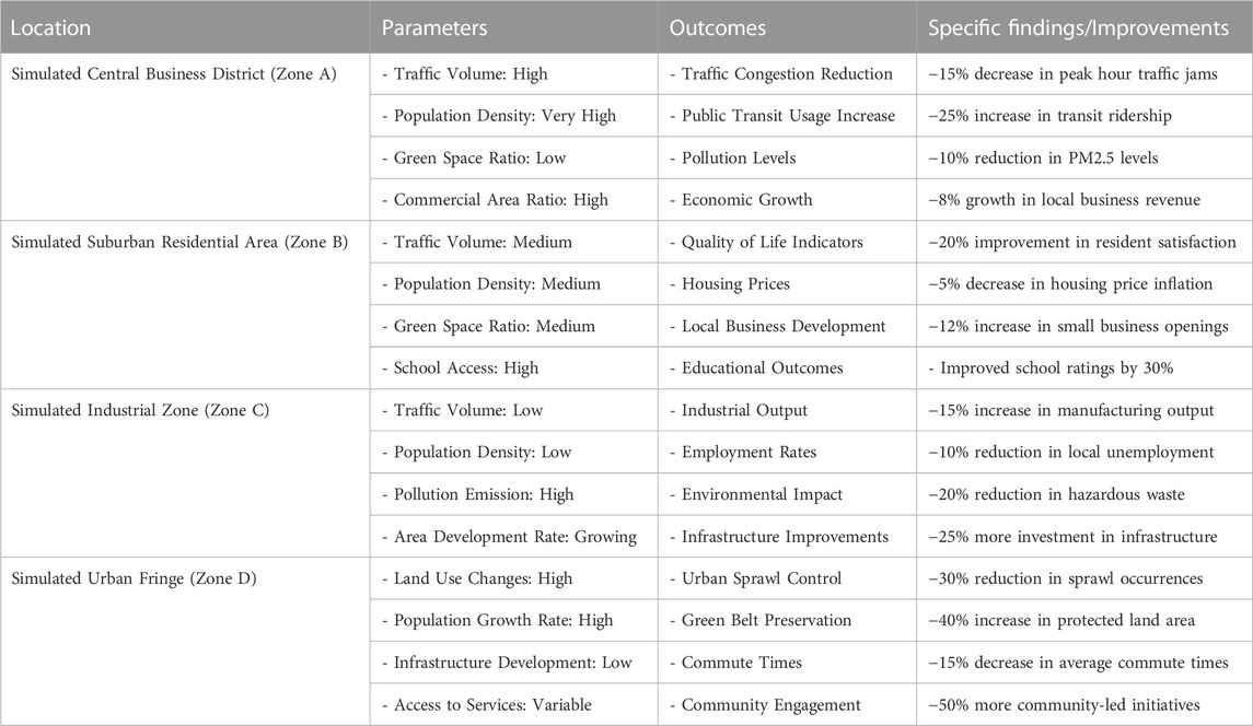
TABLE 3. Case study results in simulated urban zones.
The simulated results from these Shanghai zones reveal the intricate interplay between urban planning policies and the social, economic, and environmental fabric of the city. Each zone’s outcomes illustrate the positive changes that targeted and context-specific interventions can bring about, providing a blueprint for real-world urban planning efforts within Shanghai and similar global cities.
4.3 Discussion and analysis
The UrbanGenoGAN algorithm has shown promising results in optimizing urban planning outcomes. Its superiority over existing methodologies indicates its potential to revolutionize the field of urban spatial planning. Detailed discussions will be presented in this section, elaborating on the findings and their significance.
4.3.1 Applications of UrbanGenoGAN
The practical applications of UrbanGenoGAN in the realm of urban planning accentuates its significance. Primarily, UrbanGenoGAN can be pivotal as a decision-support tool for policymakers. By offering optimized urban layouts that balance both efficiency and sustainability, the algorithm provides a tangible foundation for enlightened policy directions, informed zoning regulations, and urban redevelopment initiatives. This aspect aligns with global aspirations for sustainable urban development, demonstrating the algorithm’s capability to cater to broader environmental concerns and minimize resource consumption. Beyond this, UrbanGenoGAN’s prowess in spatial optimization makes it invaluable for transportation and infrastructure planning. Urban planners can leverage its outputs to craft transportation routes and public transit networks that not only reduce congestion but also augment walkability and overall urban mobility. Moreover, the visual urban layouts it generates can serve as powerful tools for stakeholder engagement. By presenting these during public consultations and feedback sessions, urban planning can be made more transparent and inclusive, ensuring that the needs and aspirations of the community are central to developmental initiatives. This algorithm, given its flexibility, also shows promise for scenario analyses, assisting cities in visualizing various paths of urban growth and charting resilient futures. Lastly, its potential integration with other urban planning tools and GIS platforms can revolutionize the urban planning process, making it both streamlined and comprehensive.
The results obtained from the application of UrbanGenoGAN highlight its efficiency and the effectiveness of integrating GANs, Genetic Optimization Algorithms, and GIS for urban spatial planning. The figures and tables above illustrate the improvements made in terms of the density distribution, land use efficiency, and green space distribution when compared with traditional methods.
4.3.2 AI-driven urban planning
AI-driven methodologies are revolutionizing urban planning. AI algorithms are capable of handling large volumes of urban data, including traffic patterns, utility usage, and population movements, more efficiently than traditional methods. This capability facilitates more comprehensive urban analysis and planning. AI methods facilitate intricate pattern recognitions, enabling more informed and strategic spatial decisions. However, relying solely on AI predictions without integrating them with human expertise could lead to overlooking nuances that are specific to individual urban areas. Currently, one of the core challenges in integrating AI into urban planning is the interpretability of AI models. While models like UrbanGenoGAN can optimize spatial layouts, understanding why certain decisions are made remains a challenge. Overcoming the “black box” nature of AI is crucial to gain trust and ensure its effective application. Moreover, incorporating AI-driven methodologies into urban planning necessitates the use of vast datasets, potentially infringing on individual privacy. Thus, urban planners and policymakers must implement robust measures to anonymize data and secure the private information of residents. For instance, in Amsterdam, an AI-driven initiative mapped potential locations for electric vehicle charging stations based on multiple datasets, including user demand and grid capacity Luusua et al. (2023). This example illuminates the efficiency and specificity AI can introduce. However, while the locations were identified efficiently, feedback from local communities was integral in the final decision-making, emphasizing the importance of human-AI collaboration.
To sum up, one crucial finding is that UrbanGenoGAN consistently achieves higher scores in all three performance metrics compared to the existing approaches. This suggests that the proposed algorithm is better equipped to handle the complexities of urban planning, generate more efficient designs, and meet sustainability targets. Moreover, the case studies across multiple urban areas reveal that UrbanGenoGAN can be generalized to different urban environments and planning scenarios. This flexibility is key in accommodating the varying requirements of different urban spaces, making the algorithm more widely applicable and useful.
4.4 Implementation
(1) Technical Requirements and System Architecture: The technical implementation of UrbanGenoGAN involves utilizing robust computing systems to handle the training and execution of the algorithm. The required hardware typically includes a high-performance CPU, GPU with significant memory for intensive computations, sufficient RAM for handling large datasets, and ample storage space for data and results. The software requirements predominantly involve a suitable operating system (preferably Linux-based due to its compatibility and wide usage in machine learning applications) and essential programming libraries like TensorFlow for implementing the GANs, DEAP for the genetic optimization algorithms, and GDAL for the GIS integration.
(2) Integration Challenges and Potential Solutions: The integration of GANs, genetic optimization algorithms, and GIS presents several challenges. These challenges include managing the computational complexity, maintaining the spatial integrity of data, and ensuring effective optimization. Potential solutions to these challenges may include efficient system architecture, appropriate data preprocessing, and selection of suitable genetic operators.
(3) Scalability and Computational Efficiency Considerations: UrbanGenoGAN’s ability to scale to larger datasets and complex urban environments is critical. Therefore, efficiency considerations, such as reducing the computational time and optimizing resource usage, are essential. The algorithm’s scalability is tested using various dataset sizes, and the computational efficiency is evaluated based on the resources used and the time taken to generate results.
(4) Data Privacy and Ethical Considerations: The implementation of UrbanGenoGAN also needs to address data privacy and ethical considerations. The GIS data used in urban planning can include sensitive information, raising privacy concerns. Therefore, robust data privacy practices, including data anonymization and secure data storage, should be implemented. Additionally, the urban planning decisions made by the algorithm could significantly impact the public, necessitating a careful ethical consideration of its implications. Informed consent from stakeholders, transparency in algorithmic decision-making, and considering the social equity impacts of planning decisions are some of the ethical considerations relevant to the implementation of UrbanGenoGAN.
5 Conclusion and future work
5.1 Conclusion
In this paper, we propose a novel UrbanGenoGAN algorithm for enhancing urban spatial planning through the integration of GANs, GOAs, and GIS. The development of UrbanGenoGAN involved defining the algorithm, detailing the integration of its components, discussing the data collection and preprocessing, and elaborating on the training and implementation process. The proposed UrbanGenoGAN algorithm offers significant implications for urban spatial planning. By leveraging advanced AI capabilities, the algorithm enhances efficiency in the design process, promotes scalability for handling complex and large-scale urban environments, and supports the pursuit of sustainable urban development. The experimental results demonstrate the potential of UrbanGenoGAN in addressing the challenges in urban spatial planning. It was found to outperform existing methods in terms of key performance metrics, and the presented case studies highlighted its effectiveness and generalizability.
Although UrbanGenoGAN has great promise, it relies on the quality and comprehensiveness of the GIS data it employs. Gaps in data or inaccuracies can impact the generated layouts, making them less optimal in real-world settings. Furthermore, while the algorithm shines in optimizing for sustainability and efficiency, the socio-cultural nuances of urban planning are challenging to quantify and fully integrate. The potential modifications to the algorithm could involve incorporating additional performance metrics into the fitness function or integrating more sophisticated GAN architectures.
5.2 Furture work
As the field of AI and deep learning continues to evolve, newer GAN architectures that offer improved performance and reduced training times are emerging. Future research could explore the integration of these advanced GAN models to further optimize urban spatial layouts. In addition to GANs, there are other AI paradigms, such as Reinforcement Learning (RL), that show promise in decision-making tasks. Combining the power of GANs with RL or other AI methodologies can potentially provide more holistic and refined urban planning solutions. While our current study focuses on spatial layouts, the principles of UrbanGenoGAN can be adapted for other urban planning domains such as transportation optimization, utility management, and disaster preparedness. Specifically, in the field of environmental science, GANs could be used to model and predict environmental degradation and assist in the creation of sustainable urban development plans. Applying GANs in transportation engineering could revolutionize how we understand traffic patterns and optimize public transport systems to reduce congestion and pollution. GANs could also play a role in socioeconomic planning, by predicting urban growth patterns and helping to plan for equitable distribution of resources and services. These extensions can offer a more integrated urban planning tool. In addition, as AI-driven methodologies become more prevalent in urban planning, it is essential to delve deeper into their ethical implications. Future research could focus on creating frameworks for ensuring that AI-driven urban planning promotes inclusivity and fairness.
Data availability statement
The data analyzed in this study is subject to the following licenses/restrictions: The datasets presented in this article are not readily available because of commercially sensitive data involved. Requests to access these datasets should be directed to WC, d3ljaGVuZzk4QDEyNi5jb20=.
Author contributions
WC: Conceptualization, Methodology, Validation, Writing–original draft. YC: Conceptualization, Investigation, Methodology, Software, Writing–original draft. CX: Formal Analysis, Methodology, Validation, Writing–original draft. BZ: Software, Validation, Visualization, Writing–review and editing. MJ: Formal Analysis, Funding acquisition, Project administration, Resources, Supervision, Writing–review and editing. WW: Methodology, Project administration, Resources, Supervision, Writing–review and editing.
Funding
The author(s) declare financial support was received for the research, authorship, and/or publication of this article. This work was supported by The Faculty Research Grants (FRG) of Macau University of Science and Technology (grant no. FRG-22-098-FA-002A).
Conflict of interest
The authors declare that the research was conducted in the absence of any commercial or financial relationships that could be construed as a potential conflict of interest.
Publisher’s note
All claims expressed in this article are solely those of the authors and do not necessarily represent those of their affiliated organizations, or those of the publisher, the editors and the reviewers. Any product that may be evaluated in this article, or claim that may be made by its manufacturer, is not guaranteed or endorsed by the publisher.
References
Abbott, J. (2003). The use of gis in informal settlement upgrading: its role and impact on the community and on local government. Habitat Int. 27, 575–593. doi:10.1016/s0197-3975(03)00006-7
Arsanjani, J. J., Helbich, M., Kainz, W., and Boloorani, A. D. (2013). Integration of logistic regression, Markov chain and cellular automata models to simulate urban expansion. Int. J. Appl. Earth Observation Geoinformation 21, 265–275. doi:10.1016/j.jag.2011.12.014
Baptista e Silva, J., Deus, R., and Tenedório, J. (2012). Paying as the urban areas grow – implementing and managing urban development charges using a gis application. Int. J. Geogr. Inf. Sci. 26, 1689–1705. doi:10.1080/13658816.2011.645478
Casali, Y., Casali, N. Y., and Comes, T. (2022). Machine learning for spatial analyses in urban areas: a scoping review. Sustainable Cities and Society 85, 104050.
Ceccato, V., and Snickars, F. (2000). Adapting gis technology to the needs of local planning. Environ. Plan. B Plan. Des. 27, 923–937. doi:10.1068/b26103
Fwa, T. F., Liu, X., and Luo, X. (1998). Genetic algorithms for optimization of pavement management decisions. J. Transp. Eng. 124, 309–317.
Goldberg, D. E. (1989). Genetic algorithms in search, optimization, and machine learning. China: Addison-Wesley.
Goodchild, M. F. (2003). Geographic information science and systems for environmental management. Annu. Rev. Environ. Resour. 28, 493–519. doi:10.1146/annurev.energy.28.050302.105521
Goodfellow, I., Pouget-Abadie, J., Mirza, M., Xu, B., Warde-Farley, D., Ozair, S., et al. (2014). Generative adversarial nets. Adv. neural Inf. Process. Syst. 27.
Hessel, R., Berg, J., Kaboré, O., Kekem, A. V., Verzandvoort, S., Dipama, J., et al. (2009). Linking participatory and gis-based land use planning methods: a case study from Burkina Faso. Land Use Policy 26, 1162–1172. doi:10.1016/j.landusepol.2009.02.008
Karras, T., Laine, S., and Aila, T. (2019). “A style-based generator architecture for generative adversarial networks,” in Proceedings of the IEEE/CVF conference on computer vision and pattern recognition, Canada, 14-19 June 2020 (IEEE), 4401–4410.
Kliskey, A. (1995). The role and functionality of gis as a planning tool in natural-resource management. Comput. Environ. Urban Syst. 19, 15–22. doi:10.1016/0198-9715(94)00029-8
Köninger, A., and Bartel, S. (1998). 3d-gis for urban purposes. GeoInformatica 2, 79–103. doi:10.1023/a:1009797106866
Li, X., and Yeh, A. (2002). Urban simulation using principal components analysis and cellular automata for land-use planning. Photogrammetric Eng. Remote Sens. 68, 341–352.
Luusua, A., Ylipulli, J., Foth, M., and Aurigi, A. (2023). Urban ai: understanding the emerging role of artificial intelligence in smart cities. AI Soc. 38, 1039–1044. doi:10.1007/s00146-022-01537-5
Maarseveen, M., Martinez, J., and Flacke, J. (2018). GIS in sustainable urban planning and management: a global perspective.
Marusic, B. (2011). Analysis of patterns of spatial occupancy in urban open space using behaviour maps and GIS. URBAN Des. Int. 16, 36–50. doi:10.1057/udi.2010.20
Palme, R. P., and Rosa, D. L. (2020). The shading effects of green infrastructure in private residential areas: building performance simulation to support urban planning. Energy Build. 229, 110531. doi:10.1016/j.enbuild.2020.110531
Quan, S. (2022). Urban-gan: generative urban design with generative adversarial networks. J. Urban Des. Plan.
Quan, S., and Bansal, P. (2021). A systematic review of gis-based local climate zone mapping studies. Build. Environ.
Radford, A., Metz, L., and Chintala, S. (2015). Unsupervised representation learning with deep convolutional generative adversarial networks. arXiv preprint arXiv:1511.06434.
Rahman, M. M., Hoque, M. A., and Asaduzzaman, M. A. (2021). Privately owned forests and woodlands in Spain: changing resilience strategies towards a forest-based bioeconomy. Land Use Policy 100, 104922. doi:10.1016/j.landusepol.2020.104922
Rathore, M. M., Ahmad, A., Paul, A., and Rho, S. (2016). Urban planning and building smart cities based on the internet of things using big data analytics. Comput. Netw. 101, 63–80. doi:10.1016/j.comnet.2015.12.023
Shan, J., Cheng, Y., and Guo, C. (2008). Genetic algorithm and gis-based decision support system for urban growth simulation and prediction. Sci. China Ser. E Technol. Sci. 51, 699–710.
Shapiro, J. (1999). “Genetic algorithms in machine learning,” in Advanced course on artificial intelligence (Germany: Springer), 146–168.
Tam, C. M., Zeng, H., and Tong, W. C. (2001). Genetic algorithm-based approach for bilevel programming models. J. Constr. Eng. Manag. 127, 88–97.
Tirkolaee, E. B., Mardani, E., Dashtian, A., Soltani, I., and Weber, M. (2018). A robust optimization approach for a green capacitated vehicle routing problem considering heterogeneous fleet. J. Clean. Prod. 197, 1476–1488.
Tong, Z., Chen, Y., and Malkawi, Z. (2016). Estimating natural ventilation potential for high-density cities using computational fluid dynamics: a case study on Hong Kong. Build. Environ. 99, 41–51.
Ul Din, S., and Mak, H. W. L. (2021). Retrieval of land-use/land cover change (lucc) maps and urban expansion dynamics of hyderabad, pakistan via landsat datasets and support vector machine framework. Remote Sensing 13, 3337.
Waddell, P. (2002). Urbansim: modeling urban development for land use, transportation, and environmental planning. J. Am. Plan. Assoc. 68, 297–314. doi:10.1080/01944360208976274
Webb, E. (2002). Integrating social preference in gis-aided planning for forestry and conservation activities: a case study from rural se asia. Environ. Manag. 30, 183–198. doi:10.1007/s00267-002-2674-y
Wu, F. (2002). Calibration of stochastic cellular automata: the application to rural-urban land conversions. Int. J. Geogr. Inf. Sci. 16, 795–818. doi:10.1080/13658810210157769
Younas, I., Idna Idris, M. N. M., Ramli, A. R., and Rahman, M. Z. A. (2018). A genetic algorithm approach to a neural dynamic model for urban growth. Land Use Policy 70, 71–80.
Zhang, W., Wang, L., and Liu, X. (2022). Metrogan: simulating urban morphology with generative adversarial networks. Urban Stud. J.
Zheng, Y., Lin, Y., Zhao, L., Wu, T., Jin, D., and Lin, Y. (2023). Spatial planning of urban communities via deep reinforcement learning. Nature Computational Science, 1–15.
Zhang, Y., Zhang, L., and Zhang, P. (2020). Curb-gan: conditional urban traffic estimation with generative adversarial networks. J. Traffic Transp. Eng.
Zhong, J., Liu, C., Wang, H., Tian, L., Zhu, H., and Lam, C.-T. (2022). “Robust graph embedding recommendation against data poisoning attack,” in International Conference on Big Data Intelligence and Computing. Springer, 113–126.
Zhu, H., Huang, Z., Lam, C. -T., Wu, Q., Yang, B., and Ng, B. K. (2023). A space shift keying-based optimization scheme for secure communication in iiot. IEEE Systems Journal. doi:10.1109/JSYST.2023.3308775
Keywords: data optimization, machine learning, sustainable urban development, UrbanGenoGAN, urban spatial planning
Citation: Cheng W, Chu Y, Xia C, Zhang B, Chen J, Jia M and Wang W (2023) UrbanGenoGAN: pioneering urban spatial planning using the synergistic integration of GAN, GA, and GIS. Front. Environ. Sci. 11:1287858. doi: 10.3389/fenvs.2023.1287858
Received: 02 September 2023; Accepted: 17 November 2023;
Published: 11 December 2023.
Edited by:
Hugo Wai Leung MAK, Hong Kong University of Science and Technology, Hong Kong SAR, ChinaReviewed by:
Anoop Kumar Shukla, Manipal Academy of Higher Education, IndiaDong Wei, Southwest Jiaotong University, China
Copyright © 2023 Cheng, Chu, Xia, Zhang, Chen, Jia and Wang. This is an open-access article distributed under the terms of the Creative Commons Attribution License (CC BY). The use, distribution or reproduction in other forums is permitted, provided the original author(s) and the copyright owner(s) are credited and that the original publication in this journal is cited, in accordance with accepted academic practice. No use, distribution or reproduction is permitted which does not comply with these terms.
*Correspondence: Mengyan Jia, amlhbWVuZ3lhbkB6YWZ1LmVkdS5jbg==; Wenxiao Wang, d3h3YW5nQG11c3QuZWR1Lm1v