 Yan Xu
 Runsen Zhang2
- 1School of Geography Science and Geomatics Engineering, Suzhou University of Science and Technology, Suzhou, China
- 2Graduate School of Frontier Sciences, The University of Tokyo, Kashiwa, Japan
- 3Social Sciences Division, Japan International Research Center for Agricultural Sciences, Tsukuba, Japan
Urbanization and industrialization in developing countries has contributed to great changes in rural settlements, which presents an increasing threat to rural sustainability. Spatiotemporal changes in rural settlements at the county level are significant to land use planning and are not clear in the highly urbanized regions. This study considered Jiangsu, one of the most urbanized provinces of China, as an example and investigated the spatial variation in rural settlements and their socioeconomic driving factors during the period of 2000–2020 using mixed geographic weighted regression. The results showed that the area of rural settlements in the highly urbanized province expanded from 2000 to 2015 following a decrease in the rural population, but then began to decrease from 2015. There were obvious spatial differences in the rural settlements in the counties of Jiangsu Province. The area of rural settlements in the different counties maintained a positive association with the rural population and cropland but had a negative correlation with the rural production value in 2000. By 2020, the area of rural settlements was only positively associated with the rural population. The correlation between the area of rural settlements and rural population continually decreased from 2000 to 2020. The area of rural settlements had no significant association with the area of urban settlements. The expansion of rural settlements mainly occurred at the expense of cropland. The decrease in the rural settlements was accompanied by an increase in the urban settlements and an expansion of cropland. The policy implications arising from this study are presented to provide guidance for rural development at the county level and ensure rural sustainability.
1 Introduction
Due to global urbanization, less than half of the world’s population (46%) lived in rural areas by 2014, and the proportion is expected to further decrease to 34% by 2050 (Leeson, 2018). In 2018, rural communities still accounted for more than half of the population in other developing countries, such as India (65%) and Cambodia (76%). The population of rural areas depends on agricultural and pastoral practices in agricultural societies and varies spatially and temporally, with changes driven by industrialization and urbanization, which has altered the livelihoods and social stability of rural communities (Wright et al., 2012). The rural population has been exhibiting a persistently declining trend (Song and Liu, 2014). Rural settlements represent a multifaceted blend of physical and non-physical resources that play a crucial role in sustaining farming livelihoods. They serve as a significant, tangible manifestation of the human-land relationship (Zhao et al., 2019; Zhu et al., 2020). As the rural population dwindles, the vitality of most rural communities has progressively diminished, posing a significant challenge to sustainable urban development and regional sustainability. Monitoring the spatiotemporal changes of rural settlements can offer valuable practical insights into the evolving interaction between rural populations and their environment, thereby promoting the sustainable development of rural areas.
The type, form, and configuration of rural settlements was investigated as early as the 1930s (Hall, 1931; Scofield, 1938; Trewartha, 1946). With the development of remote sensing (RS) and geographic information system (GIS) technology, many researchers have described and explained the location, distribution, patterns, structure, changing characteristics, and function transition of rural settlements (Rey and Bachvarov, 1998; Gude et al., 2006; Feng et al., 2007; Yan et al., 2014; Jiang et al., 2022). The factors and driving forces affecting the evolution of rural settlements have been clarified and include natural geographic elements, demographics, infrastructure, industrial transformation, macroeconomic policies, and household behavior (Long and Li, 2012; Conrad et al., 2015; Amado et al., 2018; Rosner and Wesołowska, 2020; Zhang et al., 2023). Changes to rural settlements have nonnegligible environmental impacts, such as farmland and paddy soil loss in metropolitan areas (Chen and Taniguchi, 2016; Zhou et al., 2022) and environment damage in watersheds (Liao et al., 2023).
Rural revitalization is officially conducted in both developed and developing countries (Chen Y. et al., 2022). Rural revitalization is a way of positively transforming rural areas for present and future generations to create vibrant rural areas that can attract and retain employed, educated, and healthy rural residents. Rural settlements are growing in some developed countries due to rural revitalization movements (Knight, 1994). In addition, the decline of agglomeration economies has led to counter-urbanization, and polarized urban areas have been replaced with medium cities and rural locations in Italy (Salvia et al., 2020). Since the reform and opening-up policies of 1978, China has experienced substantial socioeconomic development and rapid urbanization, which has been characterized by a large population shift from rural to urban areas. As the rural population has declined, rural settlements have experienced complex changes. Rural residents have tended to migrate to urban areas to seek employment opportunities, resulting in the “hollow villages” phenomenon (Chen et al., 2017; Ma et al., 2018; Huang et al., 2020). To revitalize rural areas, national macroeconomic strategies in China emphasized the building of a “new countryside” in the early 2000s (Long et al., 2012).
Due to rapid economic growth and the population increase in cities, built-up urban areas have continued to sprawl into the surrounding countryside, which has led to a reduction in the area of rural settlements. Conversely, it has been argued that the area of rural settlements is not diminished by rural–urban migration due to China’s dual system of land ownership and dual-track structure of rural–urban development (Long et al., 2009). Rural settlements in China are part of a complex process and serve as crucial land control indicators that the Chinese government considers during the planning process (Zou et al., 2020). The spatial heterogeneity of these settlements at the county level is pivotal for sustainable rural development and regional planning. In China’s top-down land planning system, the responsibility of planning tasks falls on county-level management departments. These departments respond to indicators provided by higher level departments (Han et al., 2021), focusing on the intensity and methodology of resource development, environmental quality, and degree of stress.
Understanding the spatiotemporal characteristics and driving forces behind the evolution of rural settlements at the county level is fundamental to developing plans for the construction of new rural areas and sustainable regional planning. While numerous studies have examined on the spatiotemporal variation of rural settlements (Tian et al., 2014; Qu et al., 2017; Li and Song, 2019; Jia et al., 2020; Chen Z. et al., 2022; Tang et al., 2022), the current methods for identifying the driving factors of rural settlements primarily rely on traditional statistical analysis techniques such as regression analysis (Wang and Zhang, 2021; Liao et al., 2023), coupled analysis (Zhu et al., 2020), and redundancy analysis (Li et al., 2020). However, these methods do not consider spatial heterogeneity, where sample distributions vary across different regions and the factors influencing the dependent variable differ significantly between regions. Therefore, it is necessary to incorporate spatial relationships into the model. Mixed geographically weighted regression (MGWR) can address the limitations of traditional statistical methods by considering spatial heterogeneity for investigating the socioeconomic factors driving the development of rural settlements, especially in regions with significant spatial disparities. In this study, we determined how rural settlements have changed at the county level from 2000 to 2020 in a developed province of China. We considered three key questions: What are the spatiotemporal characteristics of changes in the area of rural settlements in a rapidly urbanized area during the last 2 decades? Is the area of rural settlements reduced by urban land expansion? What is the spatial heterogeneity of rural settlements and its relationship with socioeconomic factors? The findings will contribute to an integrated urban-rural development model, and provide a reference for land use planning, enabling managers to respond to the pressure of rapid urbanization and regional inequality.
The remainder of this paper is structured as follows. Section 2 introduces the study area, data, and research methods. Section 3 presents an analysis of the changes in the area of rural settlements, and the spatial heterogeneity of rural settlements and its driving forces. Section 4 presents a discussion of the results and the policy implications of the study. Section 5 offers some concluding insights and perspectives for future research.
2 Materials and methods
2.1 Study area
Jiangsu is an eastern-central coastal province in China, and is one of the most developed and densely populated areas of the country. It is located between 116°18′–121°57′E and 30°45′–35°20′N (Figure 1). Jiangsu has the second highest GDP of all Chinese provinces, after Guangdong. The province has a population of 85.05 million, with a population density of 793 people per km2 in 2021. It covers a total area of 107,200 km2, including 13 prefecture-level divisions and 77 county-level divisions. The province can be subdivided into three regions, i.e., northern, central, and southern Jiangsu. Central Jiangsu can be considered a transition zone between southern and northern Jiangsu. It has benefited from the reforms of 1978, with the most rapid urbanization in China occurring in Jiangsu associated with industrialization and economic development. However, a large south–north imbalance has been generated in conjunction with the economic development (Wei et al., 2020). In 2000, GDP per capita was 22,297 CNY in southern Jiangsu, but it was only 9,298 and 6,288 CNY in central and northern Jiangsu. Thus, Jiangsu Province can be considered a rapidly urbanized area and a typical case study to investigate how rural settlements have changed under the pressure of urbanization and regional inequality.
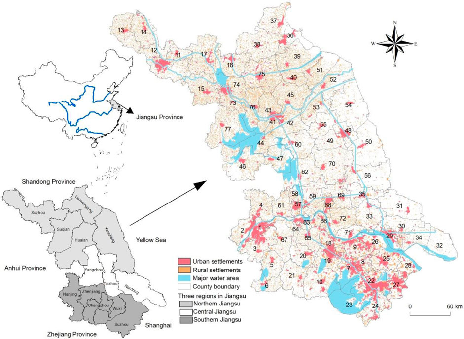
FIGURE 1. Location of the study area. The corresponding of the number and county name is at the Supplementary Table S1.
2.2 Data source
Land use and cover data with a spatial resolution of 30 × 30 m for Jiangsu province in 2000, 2005, 2010, 2015, and 2020 were obtained from the Chinese Academy of Sciences (http://www.resdc.cn/, Figure 2). Land use data were classified as cropland, forest land, grassland, water area, urban settlements, rural settlements, other built-up land, and unused land. The economic and demographic data of the 77 counties in Jiangsu Province were collected from the Jiangsu Rural Statistical Yearbook (2001–2021).
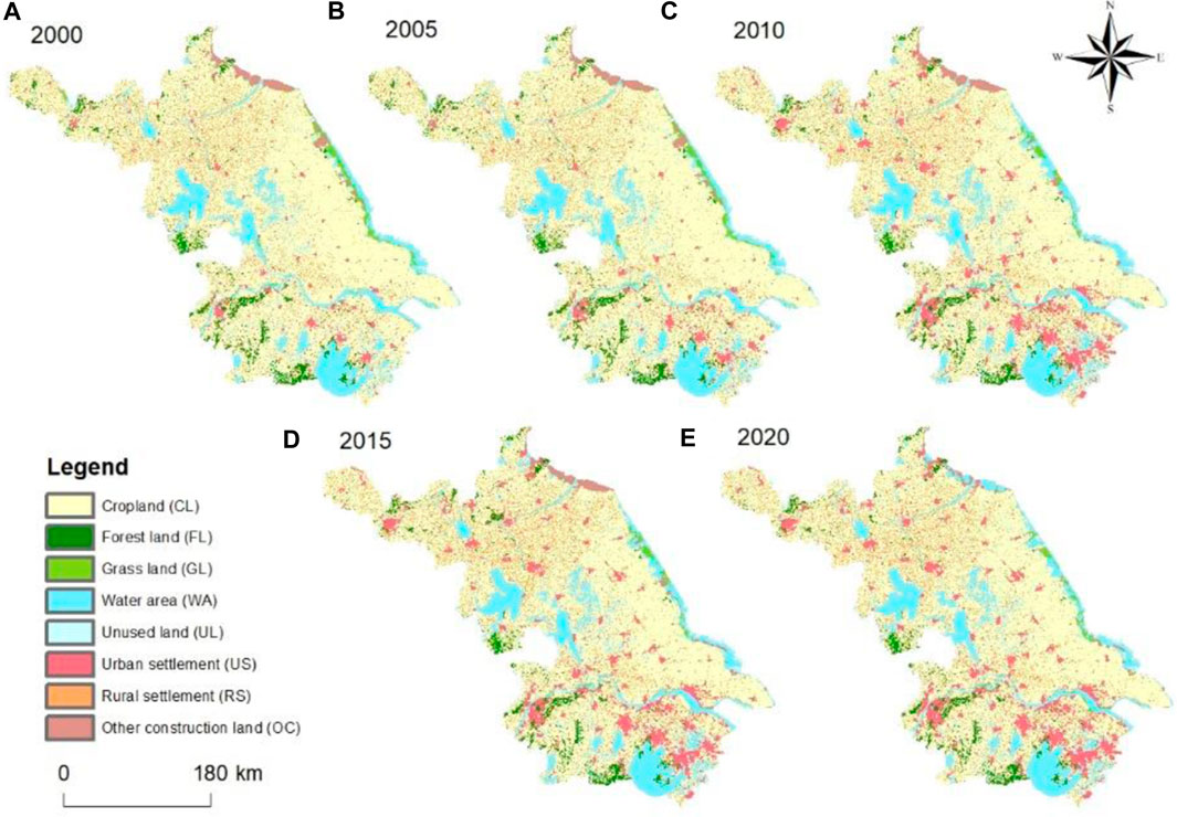
FIGURE 2. Classified land use map of Jiangsu province in 2000 (A), 2005 (B), 2010 (C), 2015 (D), and 2020 (E).
2.3 Methods
2.3.1 Degree of change index
To represent the change characteristics of rural settlements during 2000–2020, an index of the speed of change in rural settlements was used to indicate the degree of change and intensity of rural settlements at different time intervals (Li et al., 2020):
where CR is the rate of change in rural settlements at different time intervals, Aa is the area of rural settlements in the first stage, Ab is the area of rural settlements in the final stage, and T is the time interval between periods a and b.
2.3.2 Land use conversion index
In previous studies, the land use conversion structure significance index (CSS) has been used to quantify the proportional conversion of land use type i of the total net changes in rural settlements over a set period (Li et al., 2020). However, when applied in this study some information was lost in the net changes. Thus, the land use conversion index was calculated to identify the gross proportional conversion of land use type i in the total gross changes in rural settlements during the study period. The formula was as follows:
where LCIi is the proportional contribution of land use type i, and LCI varies from 0 to 1; Ar,i is the area of rural settlement converted from land use type i; Ai,r is the area of rural settlement converted into land use type i; Ain is the total area of rural settlement converted from all other land use types; and Aout is the total area of rural settlement converted into all other land use types.
2.3.3 Mixed geographic weighted regression (GWR) model
The multiple linear regression (MLR) and mixed GWR models used in this research were used to identify the driving forces of the spatial heterogeneity of rural settlements. Geographic weighted regression is a regression technique that extends the traditional regression framework by allowing the estimation of local rather than global parameters. It is a useful regression model for working with non-stationary data because it can detect where locally weighted regression coefficients move away from their global values. In GWR, the fitted coefficient values of a global model fitted to all the data may not adequately represent the detailed local variation in the data. GWR is a typical regression model with geographically varying parameters that was considered suitable for location data processing in this research. The traditional MLR model assumes that the explanatory variables are spatially stationary and only provides the global effects (Xie et al., 2021). A mixed GWR model estimates the explanatory variables with both local and global effects (Kang et al., 2010), and was formulated as follows in this study:
where yi is the dependent variable at location i, which is the area of rural settlement in county i; βj (μi,νi) is the value of the estimated parameter of the jth explanatory variable at location i; xij is the jth explanatory variable at location i, which could be rural population, rural production value, cropland area, and area of urban settlement in county i; Zim is the mth explanatory variable without local effects; rm is the coefficient of Zim and is invariant across locations; and εi is an error term.
3 Results
3.1 Spatiotemporal characteristics of rural settlements during 2000–2020
The total area of rural settlements in Jiangsu Province showed a gradually increasing trend from 10,362.98 km2 in 2000 to 11,718.07 km2 in 2015. Interestingly, the increases in the area of rural settlements from 2000 to 2015 were not consistent with the changes in rural demographics (Figure 3). After 2015, the area of rural settlements at the provincial level began to decrease, reaching 11,467.05 km2 in 2020. Figure 4 illustrates the spatial pattern of rural residential areas in Jiangsu Province, characterized by a higher concentration in the northern and western regions, and a lower concentration in the southern and eastern regions. The spatial distribution of per capita rural residential areas in this province generally aligns with the overall distribution of residential areas. Furthermore, there is a consistent upward trend in per capita rural residential areas throughout Jiangsu Province. The area of rural settlements in 77 counties of Jiangsu Province increased during 2000–2005 and 2010–2015, consistent with the provincial trend (Figure 5). The area of rural settlements in the southeastern and northwestern regions of Jiangsu Province decreased from 2005 to 2010, which differed from the provincial trend. The area of rural settlements around the Nanjing and Su-Xi-Chang metropolitan areas and the northern part of Jiangsu Province decreased from 2015 to 2020, which contrasted with the provincial trend.
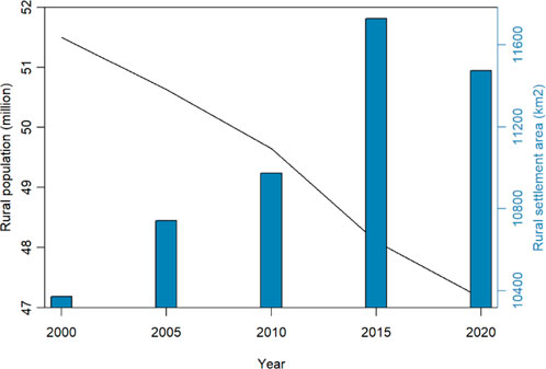
FIGURE 3. Rural population and the area of rural settlements during 2000–2020.
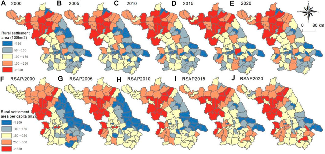
FIGURE 4. Rural settlement area of 77 counties in Jiangsu province in the years 2000 (A), 2005 (B), 2010 (C), 2015 (D), and 2020 (E). Rural settlement area per capita of 77 counties in Jiangsu province in the years 2000 (F), 2005 (G), 2010 (H), 2015 (I), and 2020 (J).
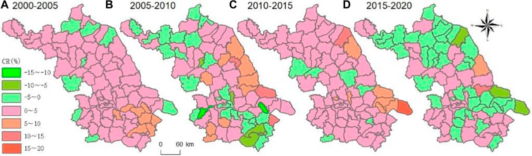
FIGURE 5. Changes in the area of rural settlements during (A) 2000–2005, (B) 2005–2010, (C) 2010–2015, and (D) 2015–2020.
3.2 Spatiotemporal characteristics of rural settlement transformation
As shown in Figure 6, there was a net increase in the area of rural settlements during 2000–2005 and 2010–2015. Cropland loss made a substantial contribution to the increased area of rural settlements, while only a small area of rural settlements was converted into cropland for food production. From 2005 to 2010, the decrease in the area of rural settlements was comparable to the increase. During this period, many rural settlements were consumed by urban settlement due to disorderly urban sprawl. From 2015 to 2020, the decrease in the area of rural settlements was much larger than the increase. Many rural settlements were converted into cropland for food production. Relatively little cropland was converted into rural settlements during the periods of 2005–2010 and 2015–2020. Changes in the area of rural settlements were mainly caused by land use transitions to cropland and urban settlements. Spatially, the proportional contribution of cropland to changes in rural settlements was very high in most counties of Jiangsu Province (Figure 7). The proportional contribution of urban settlements and other built-up land to changes in rural settlements was high in the southern counties of Jiangsu Province in both periods.
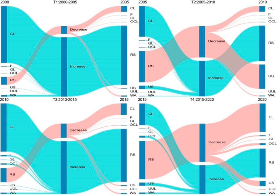
FIGURE 6. Land use transition in Jiangsu Province during (T1) 2000–2005, (T2) 2005–2010, (T3) 2010–2015, and (T4) 2015–2020. CL: cropland; F: forest; GL: grassland; OCL: other built-up land; RS: rural settlement; US: urban settlement; UUL: unused land; WA: water area.
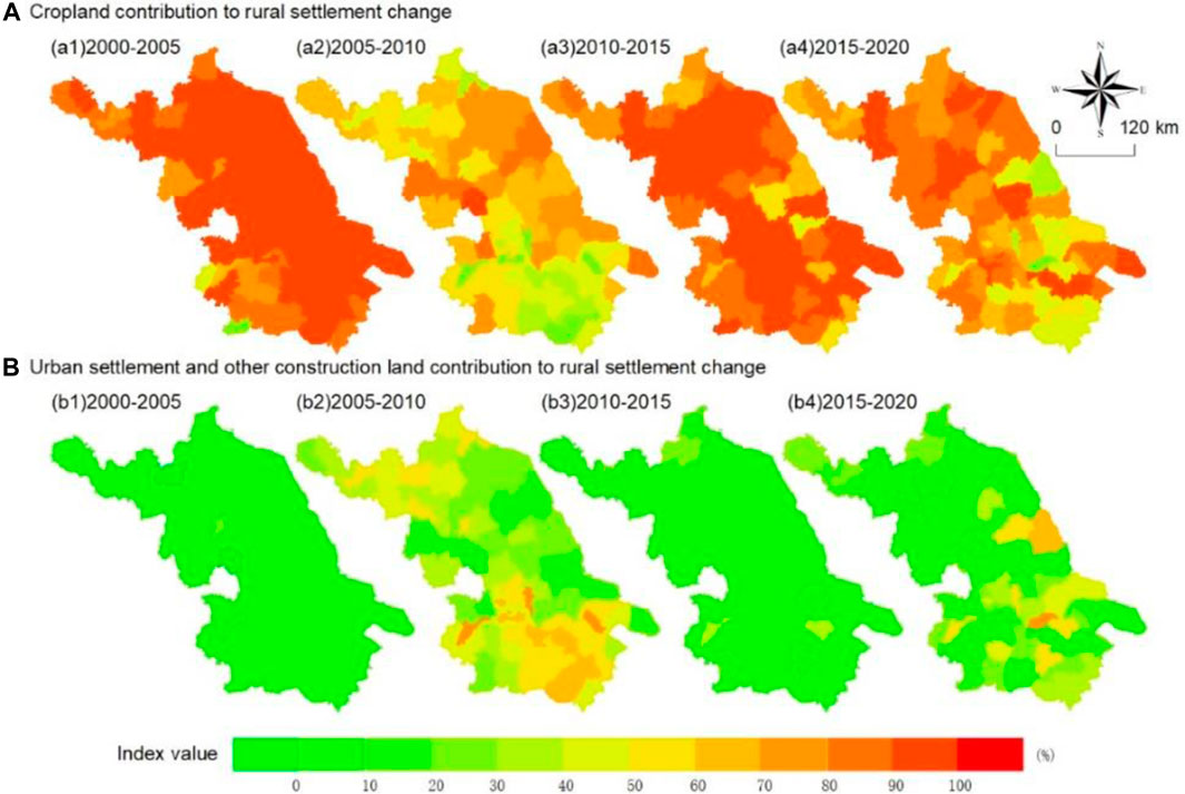
FIGURE 7. Proportional contribution of cropland to changes in the area of rural settlements at the county level in Jiangsu Province during (a1) 2000–2005, (a2) 2005–2010, (a3) 2010–2015, and (a4) 2015–2020. Urban settlement, and other built-up land to changes in the area of rural settlements at the county level in Jiangsu Province during (b1) 2000–2005, (b2) 2005–2010, (b3) 2010–2015, and (b4) 2015–2020.
3.3 Factors influencing the spatial heterogeneity of rural settlements
The performance of the MLR and mixed GWR models was compared. All variables were standardized before the estimation and their parameters were directly comparable. The variance inflation factor (VIF) values (Table 1) were all much smaller than 10, suggesting that none of the explanatory variables had collinearity issues. Both the adjusted R2 and AIC values suggested that the mixed GWR model outperformed the MLR model. The adjusted R2 values in the MLR were 0.372 and in the mixed GWR were 0.786 in 2020.
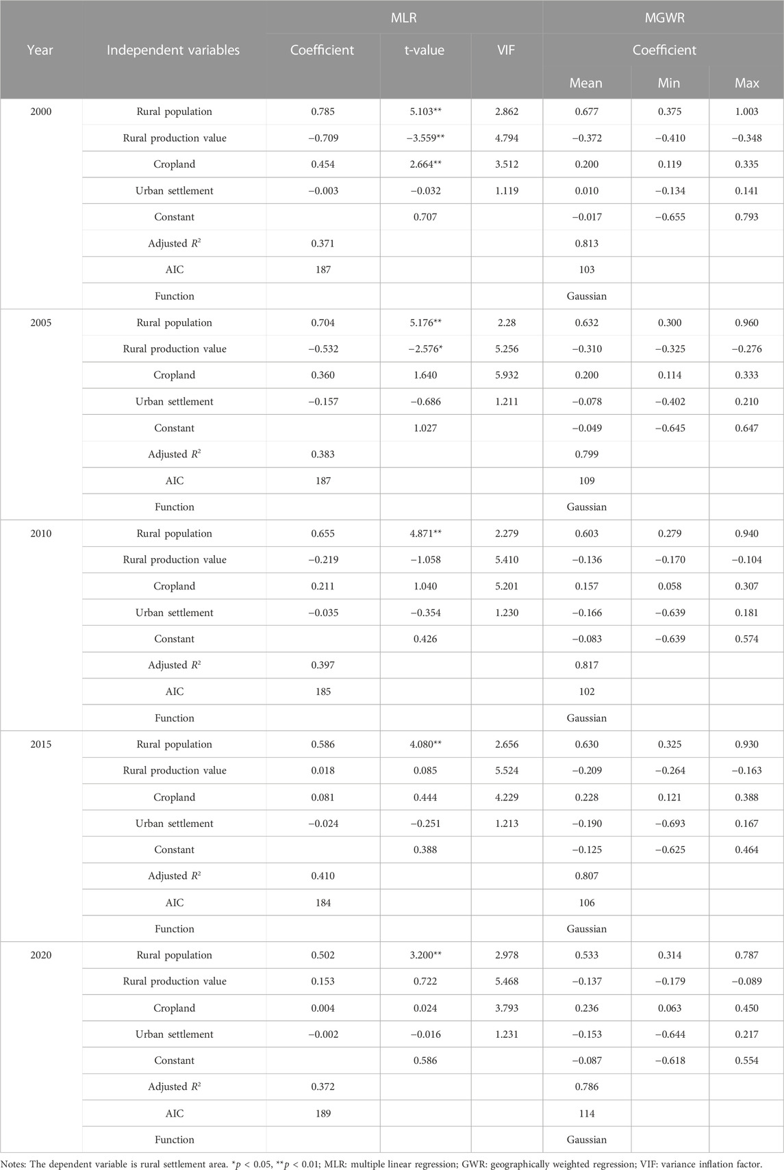
TABLE 1. Standardized estimation results of the MLR and mixed GWR models.
For the four variables with global effects, the rural population was positively associated with the area of rural settlements, and both associations were statistically significant from 2000 to 2020 (p < 0.001). Cropland was positively associated with the area of rural settlements from 2000 to 2020, although the association was only statistically significant in 2000 (p < 0.001) and was not significant from 2005 to 2020. The rural production value had a negative association with the area of rural settlements from 2000 to 2020, although the association was only significant from 2000 to 2010 (p < 0.05) and was not significant from 2010 to 2020. The area of urban settlements had a negative association with the area of rural settlements; however, the association was not statistically significant from 2000 to 2020.
Table 1 summarizes the correlation coefficients estimated from the mixed GWR model, including the average, maximum, and minimum values. The rural population had the strongest association (0.677) with the area of rural settlements, followed by the rural production value (−0.372) and cropland (0.200) in 2000. The mixed GWR results indicated that all of the variables with local effects also produced a range of estimates.
3.4 Spatial distribution of the factors influencing the area of rural settlements
Figure 8 shows the spatial differentiation of the correlations of the explanatory variables with the area of rural settlements across the counties of Jiangsu Province in 2000, 2005, 2010, 2015, and 2020. In rural areas, the correlation coefficients were positive for all counties in 2000. There were strong correlations in the northern part of Jiangsu Province and weaker correlations in the southern part. Negative associations of the rural production value with the area of rural settlements were found in all counties of Jiangsu Province at the 0.01 significance level in 2000. The correlation coefficients were similar among the different counties and were higher in the western part of Jiangsu Province. Regarding the correlation coefficients for the relationship between cropland and the area of rural settlements, most of the strong positive correlations were observed in the northwestern part of Jiangsu Province, most of which were statistically significant in 2000. There were weaker positive correlations in the eastern part of Jiangsu Province in 2000. The correlation coefficients decreased from 2005 to 2010 and increased after 2010.
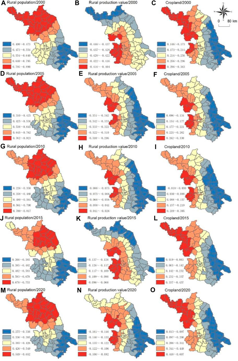
FIGURE 8. Spatial distribution of the impacts of the rural population on the area of rural settlements in the years 2000 (A), 2005 (D), 2010 (G), 2015 (J), and 2020 (M). Spatial distribution of the impacts of the rural production value on the area of rural settlements in the years 2000 (B), 2005 (E), 2010 (H), 2015 (K), and 2020 (N). Spatial distribution of the impacts of the cropland on the area of rural settlements in the years 2000 (C), 2005 (F), 2010 (I), 2015 (L), and 2020 (O).
4 Discussion
The spatial variation in the area of rural settlement and its relationships with the rural population, rural production value, cropland, and urban settlements was quantified at the prefecture level in the rapidly urbanized Jiangsu Province for the period from 2000 to 2020. In previous studies, rural settlements have often been investigated at the village (Liu et al., 2010; Wang et al., 2016) and town (Ma et al., 2018; Li et al., 2020) levels to investigate the changes in the area of rural settlements. However, planning to establish the goals and policies for long-term land use decisions typically occurs at the county level (Theobald et al., 2000). Spatial patterns and the socioeconomic factors influencing the area of rural settlements are the basic information required for regional planning. Traditionally, these driving forces have been explored using statistical models that do not consider the different spatial locations of the object being investigated (Su et al., 2020). A mixed GWR is the optimal method for analyzing the relationships among variables, particularly when there are large spatial disparities (Sun et al., 2017). This has policy implications for future sustainable rural development.
4.1 Changes in rural settlement following urbanization
Rural settlements have undergone significant changes due to urbanization and the increase in income for rural residents who move to work in cities. In developed countries, the counter-urbanization process, marked by a substantial number of people relocating to rural areas, spurs the growth of rural settlements (Gude et al., 2006). In Jiangsu Province, the trend of rural settlement expansion was observed from 2000 to 2015, followed by a contraction from 2015 to 2020, concurrent with steady decline in rural population due to urbanization (Figure 9). The average per capita residential area in rural sectors rose from 201.39 m2 in 2000 to 243.85 m2. However, it slightly reduced to 243.30 m2 by 2020. Notably, the per capita rural residential land in Jiangsu Province significantly exceeds the Chinese village and town planning standard (GB50188-93) of 150 m2 per person. Rural settlements increased in the early stages of urbanization in China, because a large number of rural residents worked in the city and took their salary back to the rural area to enlarge their settlements. After entering the rapid urban sprawl stage, some villages located near urban areas were swallowed by cities. We found that the total area of rural settlements was not reduced by the expansion of built-up urban area, which differs from previous studies that have concluded that the migration of residents from rural areas to the city for employment opportunities results in the shrinking of rural communities and settlements (Chen and Ye, 2014). Urban settlement has encroached upon cropland (57.14%) and rural settlements (23.42%) in Beijing (Liu et al., 2017). A similar situation has also been reported in Shandong Province (Qu et al., 2017). The expansion of urban and rural settlement in China has mainly been based on the loss of cropland, which has drawn the attention of the central and local governments because it endangers national food security. Since 2000, the government of Jiangsu Province has implemented several rounds of land consolidation planning (2001–2010, 2010–2020, 2015–2020). The aim of these initiatives is to increase both the area and quality of arable land, as well as promote the intensive use of construction land. Nonetheless, the per capita rural settlement area did not begin to decrease until 2015, finding that aligns with other studies (Rao, 2022). Concurrently, with a significant outflow of population, China’s rural areas began to experience recession and an aging trend. Beginning in 2017, the Chinese government introduced the concept of rural revitalization to stimulate vitality in these areas. Rural revitalization will thus be another significant factor influencing regional rural settlement trends. The rural revitalization projects necessitate careful selection of rural villages to enhance their multifunctionality. In the national rural revitalization plan, rural villages are classified into categories of urban-rural integration, concentration and enhancement, and preservation and demolition, all aimed at promoting rural development. The primarily reduction of rural settlement is seen in villages categorized for demolition.
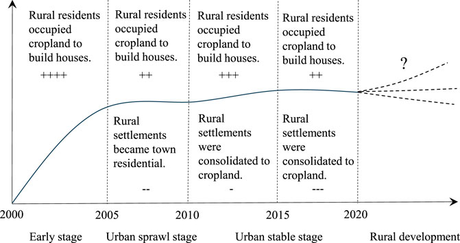
FIGURE 9. Changes in rural settlements following urbanization.
4.2 Socioeconomic driving factors of rural settlements
Rural settlements have strong connections with the rural population. From the perspective of the 77 counties in Jiangsu Province, we found that rural settlement had a strong positive relationship with the rural population, i.e., the greater the rural population, the greater the area of rural settlement. However, this relationship weakened over the period from 2000 to 2020. However, across the whole province, the area of rural settlements has shown a tendency to increase since China’s reform and opening up despite the continuous decline in the rural population. An important reason for the impact of population on changes in the area of rural settlements is the household registration system (commonly known as the hukou system) in China. Due to this system, rural–urban labor mobility only enables access to job opportunities rather than the acquisition of urban citizenship. Migrant peasant workers from rural areas are marginalized and excluded by the social security and household registration systems that prevent them from securing residency permits. These migrant workers and their families are unable to make use of the facilities and services available to non-migrant urban residents, including social insurance, healthcare, education, municipal services, and affordable housing. Therefore, they tend to keep their houses and land in rural areas and have been described as forming a “migratory bird group” in urban areas due to their bird-like migration pattern. China’s dual system of land ownership decrees that rural collectives’ own farmland and the state owns urban land. Rural residents have homestead rights although they are migrant peasant workers. They are not forced to return these rights to their collective economic organizations and therefore are inclined to hold the homestead as a rural security system. This also explains the “hollow village” phenomenon (Huang et al., 2020). In 2004, the central government of China promulgated a new land use policy named “increasing vs decreasing balance” (Gao et al., 2021). From 2005 to 2010, there was a large decrease in the area of rural settlements to accommodate the expansion in urban settlements. From 2015 to 2020, a large area of rural settlements was transferred into cropland. The costs of converting rural settlements were so high that they were covered by urban land rents and cropland conservation foundations.
In addition to the rural population, the rural production values of counties in Jiangsu Province also had a negative relationship with the area of rural settlements in 2000. Traditionally, rural settlements are associated with agriculture. For the residents of rural areas, agricultural production is the main source of family income and employment. In counties with a high rural production value, rural settlements will have agglomeration benefits (Meijers and van der Wouw, 2019). Therefore, the higher the rural production value, the lower the area of rural settlements. However, other types of rural communities have arisen due to the changing economic trends within the rural regions. The development of non-agricultural industries such as business, tourism, and manufacturing has led to a new relationship among land, people, and industry in rural areas (Rosner and Wesołowska, 2020). As one of the most developed and urbanized regions in China, Jiangsu, and particularly southern Jiangsu, has been at the forefront of rural industrialization in China. Rural enterprises and industries are considered a major vehicle in the development of rural areas, which will evolve into multifunctional rural regions.
4.3 Policy implications
Rural settlements in different counties have experienced different spatial and temporal changes due to the combined effects of multiple driving factors. The per capita rural residential area across various counties in Jiangsu Province significantly surpasses the standards established by the Chinese rural township system. Consequently, the task of consolidating and planning land and rural residential areas in Jiangsu Province presents substantial challenges. The consolidation and planning of rural residential areas within this Province should be conducted with regional differentiation in mind, specifically considering the unique needs and characteristics of the northern, southern, central, and eastern regions. For remote regions far from metropolitan areas, such as the northern, central and eastern part of Jiangsu Province, the construction of small towns and concentration of rural settlements is an important pathway for urbanization and rural development. In rural areas near to metropolitan areas, such as the southern part of Jiangsu, urban and rural construction growth need to be strictly monitored and controlled because the area of rural settlements will increase with urban land expansion, which could cause a reduction in the extent of both natural land and cropland. Although the “increasing vs decreasing balance” land use policy might appear to resolve the conflict between the demand for built-up land and the preservation of agricultural land, it is not easy to implement due to the huge financial, administrative, and social costs. The policy has been criticized because it has become a campaign to consolidate villages, and built-up land quotas and revenues have been used for urban construction rather than rural development.
A further policy implication arising from the results of our study is the need to provide affordable housing for urbanized rural residents in cities. A policy to provide affordable housing would motivate migrant peasant workers to move to urban areas and thereby give up their reliance on the rural residential land they retain as a social security system. However, the current affordable housing system in China is targeted only at urban dwellers who have city residence permits as part of the household registration system. Migrant workers, floating populations, and others without urban residence permits are not included. The government could provide affordable housing by subsidizing commercial housing purchases or by offering low-rent public housing to urbanized rural families. With a reform of the household registration system, migrant peasant workers who can access affordable housing would be likely to settle in urban areas and exchange their rural residential land for urban accommodation. Such an affordable housing policy would be effective even without a state-led policy of land consolidation, because the cost of the affordable housing would be regulated by the market mechanism and would be financially sustainable. Such a policy would be particularly important for south Jiangsu because an increasing number of migrant workers are moving there from the center and north of Jiangsu and north-central-south regional inequality is increasing.
Due to the lack of land use data for rural enterprises, the spatiotemporal characteristics of the changes in built-up rural land for industrial and production activities were not analyzed in this study. However, to determine how the economic and industrial policies in China have affected the spatiotemporal patterns of land use for rural enterprises and industries since the adoption of the reform and opening-up policy there is a need to assess the characteristics of changes in built-up rural land over the past 2 decades. This analysis will require more detailed land use information to be extracted from rural settlements.
5 Conclusion
This study investigated spatiotemporal changes in rural settlements under the pressure of rapid urbanization and widening regional inequality at the county level, taking Jiangsu Province in China as a case study. Following urbanization in the Jiangsu Province, rural settlement increased from 2000 to 2015 due to rural migrant workers expanding their settlement after making money in urban areas. Rural settlements decreased from 2015 to 2020 because of the land consolidation planning designed by the government. In accordance with policy guidance, numerous rural residential areas were transformed into towns between 2005 and 2010, and then re-designated as cultivated land from 2015 to 2020. In 2000, the area of rural settlements exhibited a positive correlation with the rural population and cropland, but a negative correlation with the rural production value. The correlation between the area of rural settlements and population decreased from 2000 to 2020. Spatial disparities between rural settlement areas and the rural population mirror the existing south-center-north imbalance. Therefore, government planning and policies should acknowledge the regional differences in the northern, central, eastern, and southern parts of Jiangsu Province. They should innovate within the rural-urban dual system and implement land consolidation strategies based on rural population size to promote sustainable rural development. Although this study revealed some details of the spatial distribution and different features of the changes in the area of rural settlements under the background of rapid urbanization and regional inequality, further studies are needed to fully address the unresolved issues.
Data availability statement
The raw data supporting the conclusion of this article will be made available by the authors, without undue reservation.
Author contributions
YX initiated this study, conducted the whole data analysis and wrote this manuscript. RZ and WW suggested the methods for this research. CY, CX, DC, and YL collected data and conducted some data analysis. All authors contributed to the article and approved the submitted version.
Funding
This study was supported by the Japan Society for the Promotion of Science (23H03600), the Humanities and Social Science Fund of Ministry of Education of China (22YJCZH208), the National Natural Science Foundation of China (41701609), and the China Scholarship Council (202208320169).
Conflict of interest
The authors declare that the research was conducted in the absence of any commercial or financial relationships that could be construed as a potential conflict of interest.
Publisher’s note
All claims expressed in this article are solely those of the authors and do not necessarily represent those of their affiliated organizations, or those of the publisher, the editors and the reviewers. Any product that may be evaluated in this article, or claim that may be made by its manufacturer, is not guaranteed or endorsed by the publisher.
Supplementary material
The Supplementary Material for this article can be found online at: https://www.frontiersin.org/articles/10.3389/fenvs.2023.1213548/full#supplementary-material
References
Amado, A. R., Amado, M., Silva, F. N., Heitor, T. V., Rodrigues, E. M., Ramalhete, I. M., et al. (2018). Planning without baseline information: Delimitation of urban and rural settlements in Oé-Cusse Ambeno, Timor-Leste. J. Urban Plan. Dev. 144, 05018016. doi:10.1061/(ASCE)UP.1943-5444.0000462
Chen, C., Gao, J. L., and Chen, J. L. (2017). Institutional changes, land use dynamics, and the transition of rural settlements in suburban China: A case study of Huishan district in Wuxi city. Habitat Int. 70, 24–33. doi:10.1016/j.habitatint.2017.09.011
Chen, H., and Taniguchi, M. (2016). Measuring sustainability for rural settlement development: Environmental balance assessment based on the ecological footprint. J. Urban Plan. Dev. 142, 04016020. doi:10.1061/(asce)up.1943-5444.0000337
Chen, M. X., and Ye, C. (2014). Differences in pattern and driving forces between urban and rural settlements in the coastal region of Ningbo, China. Sustainability 6, 1848–1867. doi:10.3390/su6041848
Chen, Y., Yu, P., Chen, Y., and Chen, Z. (2022a). Spatiotemporal dynamics of rice–crayfish field in Mid-China and its socioeconomic benefits on rural revitalisation. Appl. Geogr. 139, 102636. doi:10.1016/j.apgeog.2022.102636
Chen, Z., Li, Y., Liu, Z., Wang, J., and Liu, X. (2022b). Impacts of different rural settlement expansion patterns on eco-environment and implications in the loess hilly and gully region, China. Front. Environ. Sci. 10, 279. doi:10.3389/fenvs.2022.857776
Conrad, C., Rudloff, M., Abdullaev, I., Thiel, M., Löw, F., and Lamers, J. (2015). Measuring rural settlement expansion in Uzbekistan using remote sensing to support spatial planning. Appl. Geogr. 62, 29–43. doi:10.1016/j.apgeog.2015.03.017
Feng, W., Li, A., and Zhou, W. (2007). Spatial pattern of rural settlements in the upper reaches of the Minjiang River. J. Mt. Sci. 4, 146–154. doi:10.1007/s11629-007-0146-9
Gao, W., de Vries, W. T., and Zhao, Q. (2021). Understanding rural resettlement paths under the increasing versus decreasing balance land use policy in China. Land Use Policy 103, 105325. doi:10.1016/j.landusepol.2021.105325
Gude, P. H., Hansen, A. J., Rasker, R., and Maxwell, B. (2006). Rates and drivers of rural residential development in the Greater Yellowstone. Landsc. urban Plan. 77, 131–151. doi:10.1016/j.landurbplan.2005.02.004
Hall, R. B. (1931). Some rural settlement forms in Japan. Geogr. Rev. 21, 93–123. doi:10.2307/208949
Han, B., Jin, X., Xiang, X., Rui, S., Zhang, X., Jin, Z., et al. (2021). An integrated evaluation framework for Land-Space ecological restoration planning strategy making in rapidly developing area. Ecol. Indic. 124, 107374. doi:10.1016/j.ecolind.2021.107374
Huang, Q., Song, W., and Song, C. (2020). Consolidating the layout of rural settlements using system dynamics and the multi-agent system. J. Clean. Prod. 274, 123150. doi:10.1016/j.jclepro.2020.123150
Jia, K., Qiao, W., Chai, Y., Feng, T., Wang, Y., and Ge, D. (2020). Spatial distribution characteristics of rural settlements under diversified rural production functions: A case of taizhou, China. Habitat Int. 102, 102201. doi:10.1016/j.habitatint.2020.102201
Jiang, G., Chen, T., Zhang, R., Tian, Y., and Wu, S. (2022). A spatial patterns identification method of rural residential land change integrating dynamic and multi-scale information. Front. Environ. Sci. 10, 585. doi:10.3389/fenvs.2022.902556
Kang, D.-W., Kim, M.-y., Cho, D.-h., and Lee, S.-w. (2010). The effects of urban development pressure on agricultural land price: Application of a mixed GWR model. J. Rural Development/Nongchon-Gyeongje 33, 63–83. doi:10.22004/ag.econ.174483
Knight, J. (1994). Rural revitalization in Japan: Spirit of the village and taste of the country. Asian Surv. 34, 634–646. doi:10.2307/2645373
Leeson, G. W. (2018). The growth, ageing and urbanisation of our world. J. Popul. Ageing 11, 107–115. doi:10.1007/s12062-018-9225-7
Li, G., Jiang, C., Du, J., Jia, Y., and Bai, J. (2020). Spatial differentiation characteristics of internal ecological land structure in rural settlements and its response to natural and socio-economic conditions in the Central Plains, China. Sci. Total Environ. 709, 135932. doi:10.1016/j.scitotenv.2019.135932
Li, H., and Song, W. (2019). Expansion of rural settlements on high-quality arable land in tongzhou district in beijing, China. Sustainability 11, 5153. doi:10.3390/su11195153
Liao, B., Wang, Z., He, J., Wu, J., and Su, J. (2023). The driving mechanisms for human settlement and ecological environment in the upper minjiang watershed, China. Front. Environ. Sci. 11, 176. doi:10.3389/fenvs.2023.1097801
Liu, Y., Liu, Y., Chen, Y., and Long, H. (2010). The process and driving forces of rural hollowing in China under rapid urbanization. J. Geogr. Sci. 20, 876–888. doi:10.1007/s11442-010-0817-2
Liu, Y. S., Yang, Y. Y., Li, Y. R., and Li, J. T. (2017). Conversion from rural settlements and arable land under rapid urbanization in Beijing during 1985–2010. J. Rural Stud. 51, 141–150. doi:10.1016/j.jrurstud.2017.02.008
Long, H., and Li, T. (2012). The coupling characteristics and mechanism of farmland and rural housing land transition in China. J. Geogr. Sci. 22, 548–562. doi:10.1007/s11442-012-0946-x
Long, H., Li, Y., Liu, Y., Woods, M., and Zou, J. (2012). Accelerated restructuring in rural China fueled by ‘increasing vs. decreasing balance’land-use policy for dealing with hollowed villages. Land use policy 29, 11–22. doi:10.1016/j.landusepol.2011.04.003
Long, H., Liu, Y., Wu, X., and Dong, G. (2009). Spatio-temporal dynamic patterns of farmland and rural settlements in Su–Xi–Chang region: Implications for building a new countryside in coastal China. Land Use Policy 26, 322–333. doi:10.1016/j.landusepol.2008.04.001
Ma, W. Q., Jiang, G. H., Wang, D. Q., Li, W. Q., Guo, H. Q., and Zheng, Q. Y. (2018). Rural settlements transition (RST) in a suburban area of metropolis: Internal structure perspectives. Sci. Total Environ. 615, 672–680. doi:10.1016/j.scitotenv.2017.09.152
Meijers, E., and van der Wouw, D. (2019). Struggles and strategies of rural regions in the age of the ‘urban triumph’. J. Rural Stud. 66, 21–29. doi:10.1016/j.jrurstud.2019.01.027
Qu, Y., Jiang, G., Zhao, Q., Ma, W., Zhang, R., and Yang, Y. (2017). Geographic identification, spatial differentiation, and formation mechanism of multifunction of rural settlements: A case study of 804 typical villages in Shandong province, China. J. Clean. Prod. 166, 1202–1215. doi:10.1016/j.jclepro.2017.08.120
Rao, J. (2022). Comprehensive land consolidation as a development policy for rural vitalisation: Rural in Situ Urbanisation through semi socio-economic restructuring in Huai Town. J. Rural. Stud. 93, 386–397. doi:10.1016/j.jrurstud.2020.09.009
Rey, V., and Bachvarov, M. (1998). Rural settlements in transition–agricultural and countryside crisis in the Central-Eastern Europe. GeoJournal 44, 345–353. doi:10.1023/A:1006850525893
Rosner, A., and Wesołowska, M. (2020). Deagrarianisation of the economic structure and the evolution of rural settlement patterns in Poland. Land 9, 523. doi:10.3390/land9120523
Salvia, R., Egidi, G., Salvati, L., Rodrigo-Comino, J., and Quaranta, G. (2020). In-between ‘smart’urban growth and ‘sluggish’rural development? Reframing population dynamics in Greece, 1940–2019. Sustainability 12, 6165. doi:10.3390/su12156165
Scofield, E. (1938). The origin of settlement patterns in rural New England. Geogr. Rev. 28, 652–663. doi:10.2307/210308
Song, W., and Liu, M. (2014). Assessment of decoupling between rural settlement area and rural population in China. Land Use Policy 39, 331–341. doi:10.1016/j.landusepol.2014.02.002
Su, Y., Qian, K., Lin, L., Wang, K., Guan, T., and Gan, M. (2020). Identifying the driving forces of non-grain production expansion in rural China and its implications for policies on cultivated land protection. Land Use Policy 92, 104435. doi:10.1016/j.landusepol.2019.104435
Sun, P. L., Xu, Y. Q., Liu, Q. G., Liu, C., and Wang, H. L. (2017). Spatiotemporal evolution and driving forces of changes in rural settlements in the poverty belt around Beijing and Tianjin: A case study of Zhangjiakou city, Hebei Province. J. Mt. Sci. 14, 980–997. doi:10.1007/s11629-016-4059-3
Tang, L., Li, J., and Ding, W. (2022). Geomorphological change and rural settlement patterns: Study of the formation mechanisms of strip villages in Jiangsu, China. River Res. Appl., 1–16. doi:10.1002/rra.3944
Theobald, D. M., Hobbs, N. T., Bearly, T., Zack, J. A., Shenk, T., and Riebsame, W. E. (2000). Incorporating biological information in local land-use decision making: Designing a system for conservation planning. Landscape Ecol. 15, 35–45. doi:10.1023/A:1008165311026
Tian, G. J., Qiao, Z., and Gao, X. L. (2014). Rural settlement land dynamic modes and policy implications in Beijing metropolitan region, China. Habitat Int. 44, 237–246. doi:10.1016/j.habitatint.2014.06.010
Trewartha, G. T. (1946). Types of rural settlement in colonial America. Geogr. Rev. 36, 568–596. doi:10.2307/211416
Wang, C., Huang, B., Deng, C., Wan, Q., Zhang, L., Fei, Z. H., et al. (2016). Rural settlement restructuring based on analysis of the peasant household symbiotic system at village level: A case study of Fengsi village in Chongqing, China. J. Rural Stud. 47, 485–495. doi:10.1016/j.jrurstud.2016.07.002
Wang, J., and Zhang, Y. (2021). Analysis on the evolution of rural settlement pattern and its influencing factors in China from 1995 to 2015. Land 10, 1137. doi:10.3390/land10111137
Wei, Y. D., Wu, Y., Liao, F. H., and Zhang, L. (2020). Regional inequality, spatial polarization and place mobility in provincial China: A case study of Jiangsu province. Appl. Geogr. 124, 102296. doi:10.1016/j.apgeog.2020.102296
Wright, H. L., Lake, I. R., and Dolman, P. M. (2012). Agriculture—A key element for conservation in the developing world. Conserv. Lett. 5, 11–19. doi:10.1111/j.1755-263X.2011.00208.x
Xie, X., Wu, T., Zhu, M., Jiang, G., Xu, Y., Wang, X., et al. (2021). Comparison of random forest and multiple linear regression models for estimation of soil extracellular enzyme activities in agricultural reclaimed coastal saline land. Ecol. Indic. 120, 106925. doi:10.1016/j.ecolind.2020.106925
Yan, X., Lijie, P., and Lifang, Z. (2014). Spatial pattern and the process of settlement expansion in Jiangsu province from 1980 to 2010, eastern China. Sustainability 6, 8180–8194. doi:10.3390/su6118180
Zhang, G., Roslan, S. N. A., Quan, L., and Yuan, P. (2023). Simulation of spatiotemporal patterns of habitat quality and driving mechanism in Anhui province, China. Front. Environ. Sci. 11, 510. doi:10.3389/fenvs.2023.1145626
Zhao, X., Sun, H., Chen, B., Xia, X., and Li, P. (2019). China's rural human settlements: Qualitative evaluation, quantitative analysis and policy implications. Ecol. Indic. 105, 398–405. doi:10.1016/j.ecolind.2018.01.006
Zhou, C., Zhang, D., Cao, Y., Wang, Y., and Zhang, G. (2022). Spatio–temporal evolution and factors of climate comfort for urban human settlements in the Guangdong–Hong Kong–Macau Greater Bay Area. Front. Environ. Sci. 10, 1001064. doi:10.3389/fenvs.2022.1001064
Zhu, Z., Kong, X., and Li, Y. (2020). Identifying the static and dynamic relationships between rural population and settlements in Jiangsu province, China. Chin. Geogr. Sci. 30, 810–823. doi:10.1007/s11769-020-1150-z
Keywords: land use, human-land relationship, rural development, geographic weighted regression, spatial analysis
Citation: Xu Y, Zhang R, Wu W, Xu C, Yu C, Chen D and Liu Y (2023) Dynamic changes and driving factors of rural settlements at the county level in a rapidly urbanizing province of China from 2000 to 2020. Front. Environ. Sci. 11:1213548. doi: 10.3389/fenvs.2023.1213548
Received: 28 April 2023; Accepted: 28 June 2023;
Published: 10 July 2023.
Edited by:
Salvador García-Ayllón Veintimilla, Technical University of cartagena, SpainReviewed by:
Ying Wang, China University of Geosciences Wuhan, ChinaAnlu Zhang, Huazhong Agricultural University, China
Copyright © 2023 Xu, Zhang, Wu, Xu, Yu, Chen and Liu. This is an open-access article distributed under the terms of the Creative Commons Attribution License (CC BY). The use, distribution or reproduction in other forums is permitted, provided the original author(s) and the copyright owner(s) are credited and that the original publication in this journal is cited, in accordance with accepted academic practice. No use, distribution or reproduction is permitted which does not comply with these terms.
*Correspondence: Yan Xu, eWFueHVAdXN0cy5lZHUuY24=