
94% of researchers rate our articles as excellent or good
Learn more about the work of our research integrity team to safeguard the quality of each article we publish.
Find out more
ORIGINAL RESEARCH article
Front. Environ. Sci., 25 May 2023
Sec. Water and Wastewater Management
Volume 11 - 2023 | https://doi.org/10.3389/fenvs.2023.1179283
 S. Elkhalki1
 R. Hamed2
 S. Jodeh2*M. Ghalit1,3R. Elbarghmi1
 K. Azzaoui4
 G. Hanbali2K. Ben Zhir5B. Ait Taleb5
 A. Zarrouk6
 A. Lamhamdi1*
Groundwater is an indispensable source of water for drinking water supply, agriculture and industry worldwide. In arid and semi-arid regions, groundwater has seriously deteriorated in recent decades due to environmental changes, anthropogenic activities and marine intrusion. A total of 79 groundwater samples from the Nekor-Ghiss plain were sampled for major chemical ion analysis. These analyzes showed that the water samples were highly mineralized (>1,500 mg/L), with hardness (83.5% of the samples were very hard) and high concentrations of chemical elements, such as Cl−, Mg2+, Na+ and SO42-. To assess the quality of water in the study area for irrigation and consumption purposes, we used the quality index (GWQI) as well as a multi-criteria analysis based on “geographic information system” by assigning a weight to the different water quality parameters. Also, Piper and Durov diagram was investigated. The results of the study were focused on the water quality parameters of the collected groundwater samples, such as the sodium adsorption rate (SAR), the percentage of soluble sodium (Na%), the Residual Sodium Carbonate (RSC) and Permeability Index (PI) Majority of water samples in the study area are suitable to be used for irrigation. Magnesium Risk (MH) and Kelley’s Ratio Kelly ratio. 51.9% unsuitable samples to 59.49% good samples for irrigation purposes. Monitoring the quality and quantity of groundwater is crucial for the effective and sustainable management of this valuable resource. According to the results obtained, it appears that 92% of all the samples are located in the domain of frequent recharge waters of limestone and dolomitic aquifers, namely, Ca-Mg-HCO3. About 8% of the samples measured have a composition of the Ca-Na-Mg-HCO3 type.
Our life support system depends on groundwater, which is mostly exploited for irrigation and drinking. Water resources’ quality and quantity have increased recently as a result of population and industrial growth (Loucks and Van Beek, 2017; Adimalla and Li, 2019).
The Ghis-Nekor plain located in the North-East of Morocco is characterized by qualitative disturbances and a high density of wells, leading to overexploitation of the aquifer due to drought over the past two decades (Chafouq et al., 2018). However, overexploitation of groundwater can negatively impact groundwater quality, especially in shallow aquifers (Bouselsal and Saibi, 2022).
Particularly arid and semi-arid regions, characterized by unpredictable rainfall, often face overexploitation of groundwater and high evaporation, leading to lower groundwater levels (Hssaisoune et al., 2020). This drop in water level can also increase the risk of groundwater contamination. Despite this, the demand for drinking water in this region continues to increase. Thus, the management of water resources is a major challenge to meet this growing demand.
Natural factors like seawater intrusion, the influence of nearby aquifers, hydrodynamic conditions, the dissolution of evaporitic rocks, the influence of springs, and the effects of climate change are predominantly criticized for the degradation of groundwater quality (Ledesma-Ruiz et al., 2015; Alfarrah and Walraevens, 2018; Ouhamdouch et al., 2021; Subramaniyan et al., 2022).
Because it significantly impacts how groundwater is used for irrigation, domestic purposes, and industrial needs, comprehensive knowledge of water chemistry is crucial for accurately measuring groundwater quality, especially in rural regions (Biswas et al., 2020; Bera et al., 2021). One of the fundamental human activities on Earth is agriculture, which requires a massive million cubic meters of groundwater for plant growth (Khan et al., 2020). Access to quality water is essential to preserve a healthy environment, guarantee good health and promote the wellbeing of the population. Indeed, water is a vital resource for human beings and ecosystems. Thus, it is crucial to ensure that the water available is clean and safe, in order to prevent any contamination or risk to public health (Hunter et al., 2010; Palaniappan et al., 2010).
The “Water Quality Index” (WQI) can be defined as a parameter reflecting the overall quality of water in a given location, i.e., the cumulative effect of different water quality parameters. In the literature, various authors have described “WQI” for groundwater. In this context, the assessment of groundwater for consumption and irrigation has become necessary for the management of current and future groundwater quality (Sobeih et al., 2017; Mehrazar et al., 2020; Gabr et al., 2021).
Several studies have been conducted to assess the occurrence of seawater intrusion and the hydrochemistry of groundwater in the region, including those of Ghalit et al. (2017), Benyoussef et al., 2022, Chafouq et al. (2018), Gharibi et al. (2017), Benyoussef et al. (2021), Bouaissa et al. (2021a, 2022), Nouayti et al. (2022) and Wilcox, 1955. However, the spatial variation of irrigation water quality parameters, essential to provide useful maps for sustainable water management, has not been assessed in the study area.
In the present study, the evaluation of the physicochemical quality of groundwater in the study area is based on several water classification methods. As well as, assess the spatial extent of groundwater quality and its suitability for irrigation using a set of quality indicators. A groundwater quality index (GWQI) was generated for the entire study area to determine the suitability of water for drinking and irrigation purposes and to provide useful information for sustainable water management in the region.
As part of this work, we proceeded to a regular grid of the studied area and we selected a representative network of 79 wells, the results of which will be analyzed in this work. These wells have been the subject of surveys of measurements of the physical parameters of the water in situ [temperature (T), pH, and electrical conductivity (E.C)].
Thus, taking water samples in polythene bottles is for chemical analysis in the laboratory. Sampling and analyzes were carried out in April 2021 at the chemistry laboratory at the National School of Applied Sciences of Al-Hoceima and the National Institute of Agronomic Research (Imzouren), according to the method: The analysis water (ninth edition) (Rodier et al., 2009).
The parameters analyzed include calcium (Ca2+), magnesium (Mg2+), chlorides (Cl−), bicarbonates (HCO3−), nitrates (NO3−), nitrites (NO2−), ammonium (NH4+), ortho-phosphate (PO43-), sulphates (SO42-), sodium (Na+) and potassium (K+). Methods used included volumetric method with EDTA for calcium and magnesium, silver nitrate method (0.1 N) for chlorides, hydrochloric acid method (0.1 N) for bicarbonates, and the colorimetric assay method using a UV-VIS spectrophotometer (LANGE HACH DR-6000) for nitrates, nitrites, ammonium, ortho-phosphate and sulphates. Sodium and potassium were analyzed using a flame photometer (Model: ELICO CL 378).
The evaluation and visualization of the results were carried out using Excel 2019, AquaChem. 2014.2 and software for the Geographic Information System GIS (ArcGIS 10.8).
Piper diagram is known to be one of the most commonly used graphical tools for underground water classification based on normalized percentages of major cations (Na1+, K1+, Ca2+ and Mg2+) and major anions (Cl−, HCO3− and SO42-). Major cations and anions are depicted in Piper trilinear graphs, which are analytical tools for evaluating water samples based on their hydrochemical type and hydrological relationships. Piper charts are used to visualize the ionic composition of water samples and help determine the chemical nature of water, as well as its geological and hydrological origin.
The Nekor-Ghiss plain is part of the province of Al-Hoceima in northern Morocco on the Mediterranean coast (Figure 1). The Nekor-Ghiss plain between 3°46′, 3°49′and 3°54′West longitude and 35°13′, 35°05′and 35°12′North latitude. The study area belongs to the Riffian zone, which includes the Riffian domain extending downstream from the Nekor and Ghiss basins. It is surrounded by schist-sandstone flysch, impermeable as a whole, except in the North-West sector where limestones appear and in the North-East sector where Tortonian andesites outcrop (Chalouan et al., 2008; Salhi et al., 2008; Benabdelouahab et al., 2019).
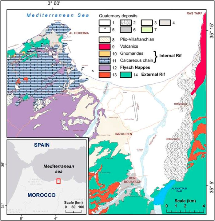
FIGURE 1. Geographical location of the Nekor-Ghiss plain.
Climate change is a major issue for many regions of the world, including the North-East of Morocco. The increase in temperatures and the reduction in precipitation forecast for this area in the years to come may accentuate the existing water deficit. The region is characterized by a semi-arid climate composed of two seasons, a wet season with a cold climate (October—May) and a dry season with a hot climate that extends from June to September (Bouras et al., 2019). It is a climate marked by an average annual precipitation of 340 mm but also by a strong seasonal and interannual irregularity (Figure 2). This irregularity is reflected in the hydrological regime of the Nekor wadi by brief and violent floods and prolonged low water levels, followed by mechanical erosion which is among the highest in Morocco (Ghalit et al., 2017).
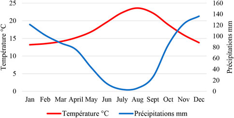
FIGURE 2. Ombrothermal diagram of the Al-Hoceima station.
The most crucial consideration is the groundwater’s quality because it is the primary determinant of its suitability for irrigation and consumption in the studied region. Table 1 presents the descriptive statistics for the different physico-chemical parameters of the groundwater samples. These data make it possible to better understand the distribution of the values of the various parameters and to describe the variability of the chemical characteristics of the water samples.
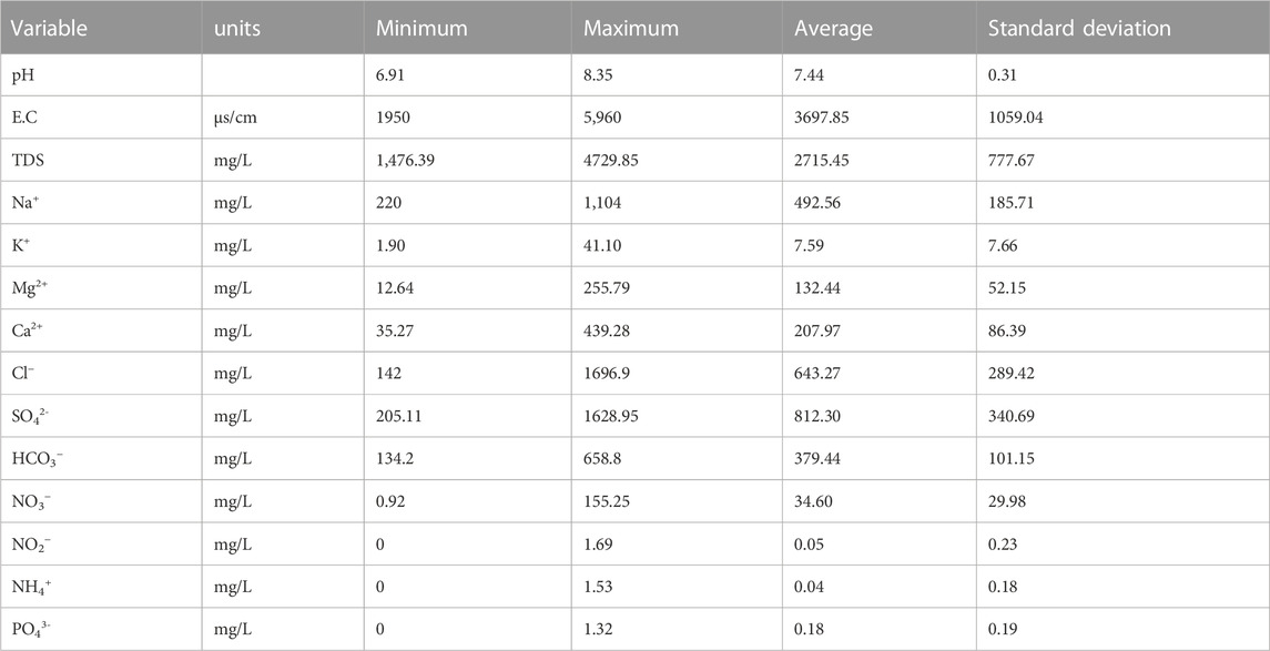
TABLE 1. Descriptive statistics of major parameters.
Numerous geological processes, including ion exchange, reverse ion exchange, evaporation, silicate weathering, water-rock interactions, sulfate reduction, oxidation processes, and human activity, have an impact on electrical conductivity (Yusuf et al., 2021; Hao et al., 2022). The findings (Table 1) demonstrate that the samples examined compared to the WHO (2022) standard (1,500 μs/cm).
According to the above classification (Table 2) of electrical conductivity, 60% of the total water samples from the study area revealed the lightly mineralized water type, and 37.97% of the water samples were moderately mineralized. The presence of a saline intrusion could be the cause of the average enrichment in electrical conductivity (EC) in the study area. Indeed, saline waters can lead to an increase in the electrical conductivity of groundwater, which can have negative effects on its use for irrigation or human consumption.
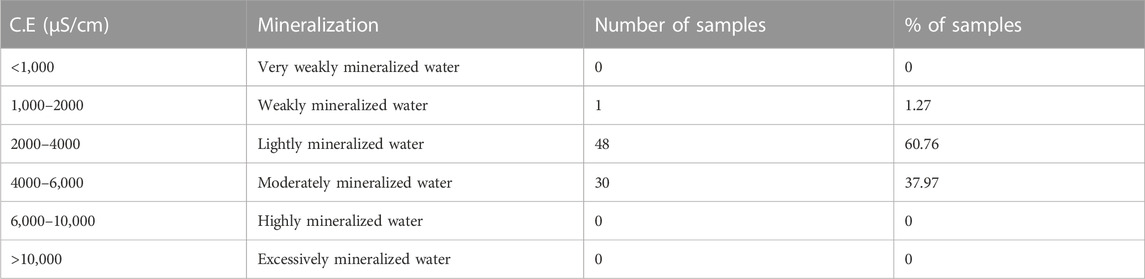
TABLE 2. Classification of groundwater samples in the Nekor-Ghiss plain according to EC (Adimalla and Taloor, 2020).
The total dissolved solids (TDS) content in groundwater in the study area ranged from 1476.39 to 4729.85 mg/L, with an average of 2715.45 mg/L (Table 3).
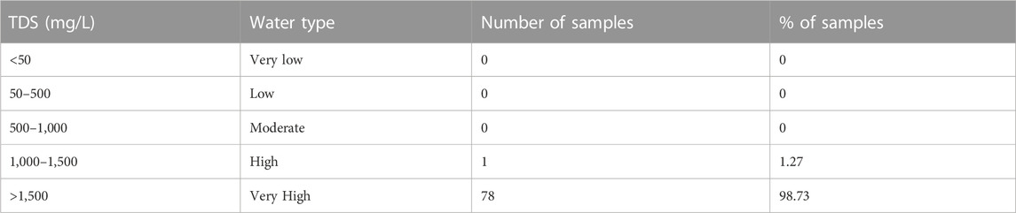
TABLE 3. Classification of groundwater samples in the Ghis-Nekor plain according to TDS (Van der Aa, 2003; Codex Alimentarius Commission, 2007).
According to the groundwater classification of Van der Aa (2003), 98.73% of the total groundwater samples had very high mineralization (TDS >1,500 mg/L) (WHO, 2022). This concentration can also be increased by marine intrusion and human activities such as domestic wastewater discharges that seep into groundwater.
Total hardness is an essential characteristic that indicates the quality of groundwater and is defined as the sum of calcium and magnesium cation concentrations expressed in mg/L (WHO, 2022). Total hardness can have an impact on the use of water for various applications, including irrigation, human consumption or even industry (Rosborg and Kozisek, 2016).
The total hardness of the groundwater studied ranges from 88 to 1096.05 mg/L of CaCO3, with an average of 592.03 mg/L of CaCO3.
According to the above classification (Table 4), only 5.06% of the total groundwater samples are Moderately Hard; 11.4% belong to the hard class; 83.54% belong to the Very hard category, which means that the majority of water samples in the study area are very hard.
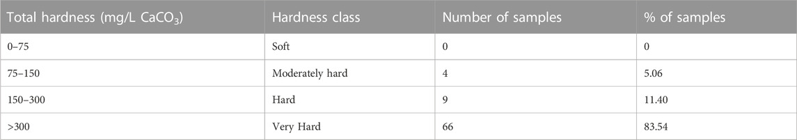
TABLE 4. Classification of groundwater samples in the Nekor-Ghiss plain based on total hardness (Sawyer and McCarty, 1967; AFSSA, 2008).
Table 5 shows the groundwater classification in the Nekor-Ghiss plain based on the dominant ions in the water.
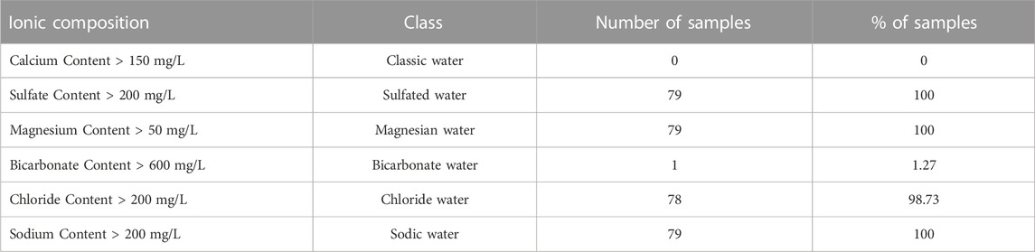
TABLE 5. Classification of groundwater samples in the Nekor-Ghiss Plain according to the dominant ions (Van der Aa, 2003).
As shown by the results in Table 5, the majority of water samples from the study area were characterized by significant mineralization, due to high concentrations of sulfate, magnesium, chloride, and sodium ions.
Across many parts of the world, groundwater quality for drinking has been evaluated using the GWQI (Adimalla and Taloor, 2020; Bouaissa et al., 2021b). A multivariate analysis is developed to create a groundwater quality index (GWQI), in order to rank the wells most suitable for human consumption.
To calculate GWQI, we based ourselves on 13 parameters (EC, TDS, HCO3−, Cl−, SO42-, PO43-, NO3−, Ca2+, Mg2+, Na+, K+, NO2− and NH4+) to which we assigned weights (wi) according to their perceived importance in the overall quality of drinking water and their impact on human health (Table 6).
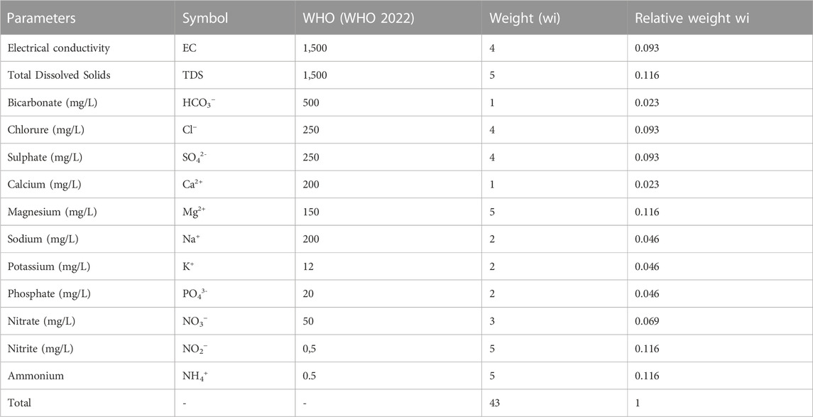
TABLE 6. Groundwater quality parameters, and their relative weights, used in the calculation of the groundwater quality index (GWQI) (WHO, 2022).
The following steps play a major role in estimating the GWQI.
(a) Calculation of relative weight (Wi): A relative weight (Wi) is calculated by the following equation:
where: “Wi”: relative weight, “wi”: weight of each parameter, “n”: number of parameters (Table 6).
(b) Quality Rating (Qi): the calculation of Qi:
where: Ci: concentration of each groundwater quality parameter, Qi: the quality rating, Si: the recommended guideline value for each chemical parameter.
According to WHO guidelines, a Quality Rating (Qi) scale for each parameter is derived from its concentration in each water sample by its respective standard and then multiplied by 100.
Finally, (c) Sub-index (SIi) and GWQI: The sub-index (SIi) and the GWQI were calculated by the following equations:
where: SIi: sub-index of the ith parameter, Qi: score based on the concentration of the ith parameter, “n”: total number of parameters.
The methodology is based on the definition of GWQI using the value of 13 cationic and anionic parameters for 79 water samples. The results of the calculations are given in Table 7.
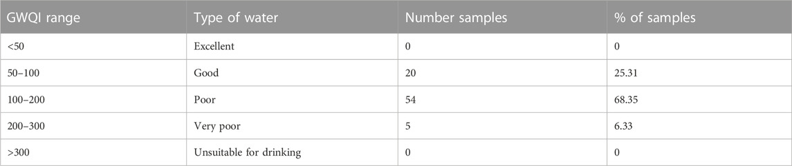
TABLE 7. Classification of groundwater intended for consumption according to the groundwater quality index (GWQI).
According to Table 7, the majority of the samples (68.35%) were classified as having “poor” quality water based on their WQI scores. This suggests that there may be issues with water quality in the study area that could have negative impacts on human health and the environment. Table 7 also notes that 25.31% of the samples were classified as having “good” quality water. This suggests that there are areas within the study area where the water quality is relatively good and may be suitable for various uses, such as drinking or irrigation. It is also worth noting that a small percentage of the samples (6.33%) were classified as having “very poor” quality water. This indicates that there are areas within the study area where the water quality is significantly degraded and may pose a risk to human health and the environment.
Overall, the results presented in Table 7 suggest that the quality of water in the study area is variable, with some areas having relatively good water quality while others are experiencing issues with water quality. The identification of areas with poor water quality is an important step in addressing water management issues and protecting human health and the environment.
According to Figure 3, most of the area was classified as having “poor quality” water based on the Water Quality Index (WQI) scores, except for the few points in the east in the study area which belonged to the good consumption class.
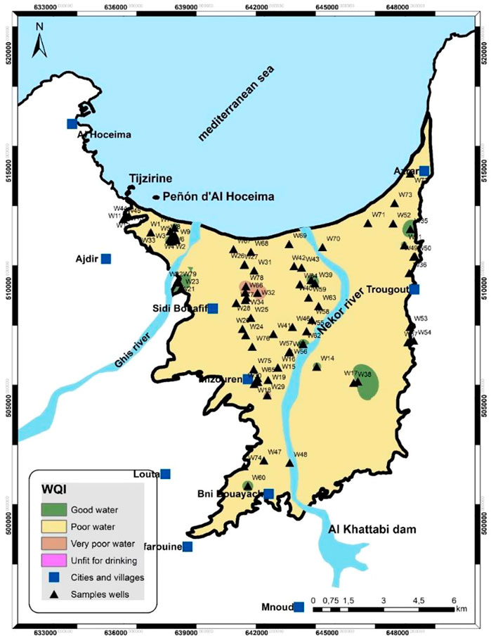
FIGURE 3. Groundwater quality index map of the plain Nekor-Ghiss.
Different indices of salinity such as electrical conductivity (EC), chloride (Cl), sodium absorption ratio (SAR), percentage of sodium (Na%), residual sodium carbonate (RSC), ratio Magnesium uptake (MAR), permeability index (PI) and Kelly ratio (KR) are important parameters for assessing groundwater quality for agricultural use. These indices are used to determine the salinity and toxicity of groundwater based on different criteria, such as the ability of water to be absorbed by soils, the amount of salt dissolved in the water. Evaluation of these indices is crucial in determining the suitability of groundwater for irrigation and other agricultural uses (Salifu et al., 2017).
Overall, these indices are essential tools for evaluating the suitability of groundwater for agricultural use and can help in managing soil and water resources effectively. By evaluating and mapping these parameters, farmers and irrigation professionals can make informed decisions about water use and management.
According to the EC value, groundwater samples are classified into different categories (Table 1). The Conductivity of the samples studied varies between 1950 and 5,960 (µs/cm), with an average of 3697.85 (µs/cm), the majority of the samples from the study area are not acceptable for agricultural use. The origin of chloride in groundwater can be from various sources such as saltwater intrusion and windblown salt in precipitation.
The most predominant ions in irrigation water are chloride and sodium, both of which can impact crops (Şener et al., 2022). The origin of chloride in groundwater can be from various sources such as saltwater intrusion and salt carried by the wind in precipitation (Li et al., 2020). Excess chloride in water is generally taken as an index of pollution and considered as a tracer of groundwater contamination (Boateng et al., 2016). Chloride determinations can be used to indicate the intrusion of waters of different composition or to trace and measure the velocities and volumes of water mass movements.
In our study area, the chloride contents of the groundwater analyzed ranged from 4 meq/L to 47.86 meq/L, with an average of 18.14 meq/L. Only 20.25% of the water samples are of acceptable quality for agricultural use.
Chloride is higher in the area between the rivers (Nekor and Ghis) and the eastern edge of the plain (Figure 5).
The sodium absorption ratio (SAR) is one of the most crucial factors in assessing the danger of soil sodification (Madene et al., 2022). The SAR is determined by the following equation which is invented by Richards (1954):
Classification of groundwater samples based on SAR values shows that 92.41% of water samples from the study area had SAR values below 12, which shows that the majority of samples were suitable for irrigation (Figure 4).

FIGURE 4. SAR values for the water samples studied.
SAR values are low in most of the study area, except for a few points on the eastern edge of the plain (Figure 5).
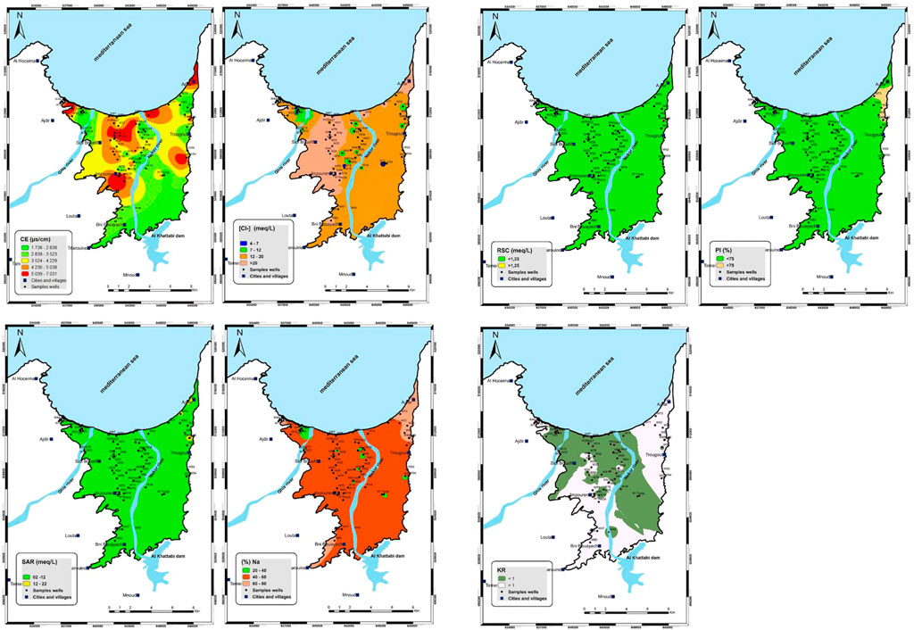
FIGURE 5. Spatial distribution maps of irrigation water quality assessment indices in the study area: EC, Cl−, SAR, Na%, RSC, PI and KR.
When analyzing the quality of water for agricultural consumption, another essential indicator to take into account is the percentage of sodium. The %Na is calculated using the equation as follows:
The results of the quality assessment of groundwater samples based on Na% (Wilcox and Durum, 1967) shows that 21.52% of the samples are of good quality in the western edge of the plain, about 56.96% of the samples are permissible for irrigation in most of the study area and only about 21.52% have questionable class in the eastern edge of the plain (Table 8; Figure 5).
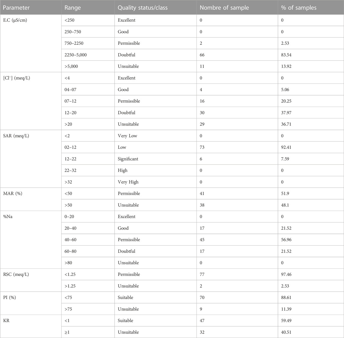
TABLE 8. Methodology for determination of different parameters/indices of groundwater quality for agricultural use.
High levels of carbonate and bicarbonate relative to magnesium and calcium in groundwater samples can affect soil permeability (Amiri et al., 2021). Evaluation of the RSC index is important in determining the quality of groundwater for irrigation, because a high RSC can indicate the presence of an excessive amount of carbonate and bicarbonate in the water, which can affect the ability of soils to absorb water and nutrients needed for crop growth.
This behavior can be demonstrated by calculating residual sodium carbonate (RSC) from the following equation (Eaton, 1950):
In the study area, 77 water samples had RSC values below 1.25 meq/L (Figure 4), indicating that the quality of 97.46% of the water samples was suitable for irrigation according to their RSC values (Table 8; Figure 4).
Magnesium excess in groundwater can affect the structure of the soil and lower agricultural productivity (Nagaraju et al., 2014). According to the values of (MAR) (in %), the samples are classified into two classes, appropriate (MAR ≤50) or inappropriate (MAR >50). The MAR is calculated by the following formula:
Based on MAR values (in %), the results show that 41 studied water samples had good quality (MAR ≤50) for irrigation, and 38 groundwater samples exceeded the excess threshold. of MAR (MAR >50), which means that 48.1% of water samples had poor quality for irrigation based on their MAR values (Figure 5).
The soil permeability index (Doneen, 1964) is calculated using the relationship below:
The concentrations of the water samples are quantified in milliequivalents per liter (meq/L). The results show that 70 water samples had PI values lower than 75%, indicating the good quality of the majority of groundwater for irrigation (Figure 5).
Kelly’s ratio is used to determine the quality of irrigation water (Kelley, 1940), This ratio measures the concentration of Na+ in the water relative to the total concentration of Mg2+ and Ca2+, the KR is given by the following formula:
Based on KR, when KR is <1, it means the water quality is suitable for irrigation, on the other hand, KR is >1, it means the water quality for irrigation is inappropriate, as shown in the table. 47 wells studied had KR values <1, which means that 59.49% of these waters had good quality for agricultural use, on the other hand, 32 water samples had KR values >1, which indicates that 40.51% were unsuitable for irrigation (Figure 5).
The results were plotted using the Piper diagram (Piper, 1944) and were classified as terrestrial alkaline waters with a predominance of bicarbonates, as shown in Figure 6. About 92% of the samples were classified as the Ca-Mg-HCO3 domain, which generally corresponds to groundwater fed by limestone and dolomitic aquifers. About 8% of the samples showed a chemical composition of Ca-Na-Mg-HCO3 type. The use of the Piper diagram is useful for understanding groundwater quality in terms of its chemical composition, which can help identify potential sources of contamination and hydrological processes that affect water quality.
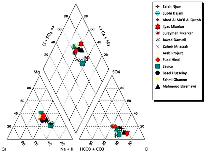
FIGURE 6. Piper Trilinear Plot for Jericho wells for fall and spring rounds Combined.
The Ghis-Nekor aquifer in northern Morocco was investigated to evaluate the quality of groundwater and to determine whether the groundwater in this study region is adequate for use in agriculture and human consumption. This coastal plain is mainly fed by the Nekor River, the Ghis River which intervenes in the northwestern end, and the Al-Khattabi Dam. The groundwater of this aquifer is characterized by significant mineralization (>1,500 mg/L). For this reason, the majority of the wells sampled show high values of electrical conductivity with an average of 3697.85 μs/cm. The interpretation of Physico-chemical analyzes reveals that the majority of groundwater in the region is very hard. According to the (GWQI), groundwater quality in the study area is generally poor to good for drinking purposes. The classification of groundwater according to its chemical composition shows that the main dominant cations and anions in our study area are the following Cl−, SO42-, Na+, and Mg2+. On the other hand, according to our results based on the values of SAR, %Na, RSC, and PI, the majority of groundwater wells analyzed were considered permissible for all agricultural use. According to the parameters of KR, 59.49% of the water samples belong to the category suitable for irrigation. On the other hand, the MAR values show that almost half of the water samples belong to the category permissible for irrigation. The results also shows that 92% of all samples are falling in the domain of Ca—Mg—HCO3 which frequently recharges water in limestone and dolomite aquifers and about 8% of the measured samples showed the water type of Ca-Na-Mg-HCO3.
In particular, this study is very useful for farmers and inhabitants of the region to take the necessary management and protection measures and adopt rational behaviors for sustainable use of these groundwaters. It is therefore essential to continue efforts to better understand the quantity and quality of groundwater in coastal areas, as well as to work towards the development of viable management policies.
The original contributions presented in the study are included in the article/supplementary material, further inquiries can be directed to the corresponding authors.
All authors listed have made a substantial, direct, and intellectual contribution to the work and approved it for publication.
The authors declare that the research was conducted in the absence of any commercial or financial relationships that could be construed as a potential conflict of interest.
All claims expressed in this article are solely those of the authors and do not necessarily represent those of their affiliated organizations, or those of the publisher, the editors and the reviewers. Any product that may be evaluated in this article, or claim that may be made by its manufacturer, is not guaranteed or endorsed by the publisher.
Adimalla, N., and Li, P. (2019). Occurrence, health risks, and geochemical mechanisms of fluoride and nitrate in groundwater of the rock-dominant semi-arid region, Telangana State, India. Hum. Ecol. Risk Assess. 25 (1–2), 81–103. doi:10.1080/10807039.2018.1480353
Adimalla, N., and Taloor, A. K. (2020). Hydrogeochemical investigation of groundwater quality in the hard rock terrain of South India using Geographic Information System (GIS) and groundwater quality index (GWQI) techniques. Groundw. Sustain. Dev. 10, 100288. doi:10.1016/j.gsd.2019.100288
Afssa, (2008). Guidelines for the safety assessment of natural mineral waters. Maisons-Alfort: French Food Safety Agency.
Alfarrah, N., and Walraevens, K. (2018). Groundwater overexploitation and seawater intrusion in coastal areas of arid and semi-arid regions. Water 10 (2), 143. doi:10.3390/w10020143
Amiri, V., Bhattacharya, P., and Nakhaei, M. (2021). The hydrogeochemical evaluation of groundwater resources and their suitability for agricultural and industrial uses in an arid area of Iran. Groundw. Sustain. Dev. 12, 100527. doi:10.1016/j.gsd.2020.100527
Benabdelouahab, S., Salhi, A., Himi, M., El Messari, J. E. S., and Ponsati, A. C. (2019). Geoelectrical investigations for aquifer characterization and geoenvironmental assessment in northern Morocco. Environ. earth Sci. 78 (6), 209–216. doi:10.1007/s12665-019-8221-4
Benyoussef, S., Arabi, M., El Ouarghi, H., Ghalit, M., El Yousfi, Y., Azirar, M., et al. (2022). Qualitative assessment of the waters of the coastal aquifer Ghis-Nekor (Central Rif, Northern Morocco) in view of agricultural use. J. Water Land Dev. doi:10.24425/jwld.2022.140395
Benyoussef, S., El Ouarghi, H., Arabi, M., El Yousfi, Y., Azirar, M., and Boughrous, A. A. (2021). “Assessment of the impact of Imzouren city’s WWTP on the quality of the surrounding groundwater, at the Rif Central (Northern Morocco),” in E3S web of conferences (Les Ulis, France: EDP Sciences), 240, 01008. doi:10.1051/e3sconf/202124001008
Bera, A., Mukhopadhyay, B. .P., Chowdhury, P., Ghosh, A., and Biswas, S. (2021). Groundwater vulnerability assessment using GIS-based DRASTIC model in Nangasai River Basin, India with special emphasis on agricultural contamination. Ecotoxicol. Environ. Saf. 214, 112085. doi:10.1016/j.ecoenv.2021.112085
Biswas, S., Mukhopadhyay, B. .P., and Bera, A. (2020). Delineating groundwater potential zones of agriculture dominated landscapes using GIS based AHP techniques: A case study from uttar dinajpur district. West bengal. Environ. Earth Sci. 79 (12), 302–325. doi:10.1007/s12665-020-09053-9
Boateng, T. K., Opoku, F., Acquaah, S. O., and Akoto, O. (2016). Groundwater quality assessment using statistical approach and water quality index in Ejisu-Juaben Municipality, Ghana. Environ. Earth Sci. 75, 489–514. doi:10.1007/s12665-015-5105-0
Bouaissa, M., Ghalit, M., Taupin, J. D., Patris, N., Khattabi, J. E., and Gharibi, E. (2021b). Assessment of medium mountain groundwater for consumption and irrigation using quality index method: Application to the bokoya massif (central rif, northern Morocco). Arabian J. Geosciences 14 (4), 242–313. doi:10.1007/s12517-021-06592-8
Bouaissa, M., Gharibi, E., Ghalit, M., Taupin, J. D., Boukich, O., El Khattabi, J., et al. (2022). The changing face of HR professionals' expectations amidst COVID-19: A comparison in between Sri Lanka and foreign context. Int. J. Environ. Anal. Chem. 22, 1–20. doi:10.1007/s11135-022-01533-3
Bouaissa, M., Gharibi, E., Ghalit, M., Taupin, J. D., and El Khattabi, J. (2021a). Identifying the origin of groundwater salinization in the Bokoya massif (central Rif, northern Morocco) using hydrogeochemical and isotopic tools. Groundw. Sustain. Dev. 14, 100646. doi:10.1016/j.gsd.2021.100646
Bouras, E., Jarlan, L., Khabba, S., Er-Raki, S., Dezetter, A., Sghir, F., et al. (2019). Assessing the impact of global climate changes on irrigated wheat yields and water requirements in a semi-arid environment of Morocco. Sci. Rep. 9 (1), 19142. doi:10.1038/s41598-019-55251-2
Bouselsal, B., and Saibi, H. (2022). Evaluation of groundwater quality and hydrochemical characteristics in the shallow aquifer of El-Oued region (Algerian Sahara). Groundw. Sustain. Dev. 17, 100747. doi:10.1016/j.gsd.2022.100747
Chafouq, D., El Mandour, A., El Gettafi, M., Himi, M., Chouikri, I., and Casas, A. (2018). Hydrochemical and isotopic characterization of groundwater in the Ghis-Nekor plain (northern Morocco). J. Afr. Earth Sci. 139, 1–13. doi:10.1016/j.jafrearsci.2017.11.007
Chalouan, A., Michard, A., El Kadiri, K., Negro, F., de Lamotte, D. F., Soto, J., et al. (2008). “The rif belt,” in Continental evolution: The geology of Morocco (New York: Springer), 203–302. doi:10.1007/978-3-540-77076-3_5
Codex Alimentarius Commission (2007). Codex standard for natural mineral waters. Rome: Codex Alimentarius Commission.
Doneen, L. D. (1964). Notes on water quality in agriculture. Davis: Department of Water Science and Engineering, University of California.
Eaton, F. .M. (1950). Significance of carbonate in irrigation water. Soil Sci. 69 (2), 123–134. doi:10.1097/00010694-195002000-00004
Gabr, M. E., Soussa, H., and Fattouh, E. (2021). Groundwater quality evaluation for drinking and irrigation uses in Dayrout city Upper Egypt. Ain Shams Eng. J. 12 (1), 327–340. doi:10.1016/j.asej.2020.05.010
Ghalit, M., Yousfi, E. B., Zouhairi, M., Gharibi, E., and Taupin, J. D. (2017). Hydrochemical characterization of groundwater in the Nekor basin located in the North-East of the Rif of Morocco. Moroc. J. Chem. 5 (2), 5–2. doi:10.48317/IMIST.PRSM/morjchem-v5i2.8087
Gharibi, E., Ghalit, M., Taupin, J. D., and Lamhamdi, A. (2017). Effect of saltwater intrusion due to over-exploitation and earthquakes on mineralization processes of spring waters over the Massif Bokkoya (central Rif, Morocco). J. Water Supply Res. Technology-Aqua 66 (4), 279–286. doi:10.2166/aqua.2017.112
Hao, C., Sun, X., Xie, B., and Hou, S. (2022). Increase in fluoride concentration in mine water in Shendong mining area, Northwest China: Insights from isotopic and geochemical signatures. Ecotoxicol. Environ. Saf. 236, 113496. doi:10.1016/j.ecoenv.2022.113496
Hssaisoune, M., Bouchaou, L., Sifeddine, A., Bouimetarhan, I., and Chehbouni, A. (2020). Moroccan groundwater resources and evolution with global climate changes. Geosciences 10 (2), 81. doi:10.3390/geosciences10020081
Hunter, P. .R., MacDonald, A. .M., and Carter, R. .C. (2010). Water supply and health. PLoS Med. 7 (11), e1000361. doi:10.1371/journal.pmed.1000361
Kelly, W. .P. (1940). “Permissible composition and concentration of irrigated waters,” in Proceedings of the A.S.C.E (United States: asce library), 607.
Khan, A. F., Srinivasamoorthy, K., and Rabina, C. (2020). Hydrochemical characteristics and quality assessment of groundwater along the coastal tracts of Tamil Nadu and Puducherry, India. Appl. Water Sci. 10, 74–21. doi:10.1007/s13201-020-1158-7
Ledesma-Ruiz, R., Past´en-Zapata, E., Parra, R., Harter, T., and Mahlknecht, J. (2015). Investigation of the geochemical evolution of groundwater under agricultural land: A case study in northeastern Mexico. J. Hydrol. 521, 410–423. doi:10.1016/j.jhydrol.2014.12.026
Li, C., Gao, X., Li, S., and Bundschuh, J. (2020). A review of the distribution, sources, Genesis, and environmental concerns of salinity in groundwater. Environ. Sci. Pollut. Res. 27 (33), 41157–41174. doi:10.1007/s11356-020-10354-6
Loucks, D. P., and Van Beek, E. (2017). Water resource systems planning and management: An introduction to methods, models, and applications. Berlin, Germany: Springer.
Madene, E., Boufekane, A., Meddi, M., Busico, G., and Zghibi, A. (2022). Spatial analysis and mapping of the groundwater quality index for drinking and irrigation purpose in the alluvial aquifers of upper and middle Cheliff basin (north-west Algeria). Water Supply 22 (4), 4422–4444. doi:10.2166/ws.2022.107
Mehrazar, A., Bavani, A. .R. .M., Gohari, A., Mashal, M., and Rahimikhoob, H. (2020). Adaptation of water resources system to water scarcity and climate change in the suburb area of megacities. Water Resour. Manag. 34, 3855–3877. doi:10.1007/s11269-020-02648-8
Nagaraju, A., Kumar, K. .S., and Thejaswi, A. (2014). Assessment of groundwater quality for irrigation: A case study from bandalamottu lead mining area, guntur district, Andhra Pradesh, south India. Appl. Water Sci. 4 (4), 385–396. doi:10.1007/s13201-014-0154-1
Nouayti, N., Cherif, E. K., Algarra, M., Pola, M. L., Fernández, S., Nouayti, A., et al. (2022). Determination of physicochemical water quality of the ghis-nekor aquifer (Al hoceima, Morocco) using hydrochemistry, multiple isotopic tracers, and the geographical information system (GIS). Water 14 (4), 606. doi:10.3390/w14040606
Ouhamdouch, S., Bahir, M., and Ouazar, O. (2021). Seawater intrusion into coastal aquifers from semi-arid environments, Case of the alluvial aquifer of Essaouira basin (Morocco). Carbonates Evaporites 36, 5–12. doi:10.1007/s13146-020-00663-9
Palaniappan, M., Gleick, P. H., Allen, L., Cohen, M. J., Christian-Smith, J., Smith, C., et al. (2010). Clearing the waters: A focus on water quality solutions. Available at: http://hdl.handle.net/20.500.11822/7906.
Piper, A. M. (1944). A graphic procedure in the geochemical interpretation of water-analyses. Eos, Trans. Am. Geophys. Union 25 (6), 914–928. doi:10.1029/tr025i006p00914
Rodier, J., Legube, B., Merlet, N., and Brunet, R. (2009). L’analyse de l’eau [water analysis]. Paris: Dunod.
Rosborg, I., and Kozisek, F. (2016). Drinking water minerals and mineral balance. Springer International Pu.
Salhi, A., El Messari, J. S., Benabdelouahab, S., El Gettafi, M., Díaz, Y., Himi, M., et al. (2008). Cartografía comparativa de la vulnerabilidad del acuífero costero de Ghis-Nekor (Marruecos). Geogaceta 44, 167–170.
Salifu, M., Aidoo, F., Hayford, M. S., Adomako, D., and Asare, E. (2017). Evaluating the suitability of groundwater for irrigational purposes in some selected districts of the Upper West region of Ghana. Appl. water Sci. 7, 653–662. doi:10.1007/s13201-015-0277-z
Sawyer, C. .N., and McCarty, P. .L. (1967). Chemistry for sanitary engineers. 2nd edn. New York: McGraw-Hill, 518.
ŞenerŞener Ş, E., and Varol, S. (2022). Evaluation of irrigation water quality using GIS-based analytic hierarchy process (AHP) in kızılırmak delta (Turkey). Arabian J. Geosciences 15 (8), 678–719. doi:10.1007/s12517-022-10003-x
Sobeih, M. M., El-Arabi, N. E., Helal, E. E. D. Y., and Awad, B. S. (2017). Management of water resources to control groundwater levels in the southern area of the Western Nile delta, Egypt. Water Sci. 31 (2), 137–150. doi:10.1016/j.wsj.2017.09.001
Subramaniyan, A., Karthikeyan, B., and Lakshmanan, E. (2022). Geochemical evaluation of fluoride and groundwater quality for drinking and irrigation purposes in a weathered gneissic rock aquifer of southern penisular India. Environ. Earth Sci. 81 (9), 273–317. doi:10.1007/s12665-022-10395-9
Van der Aa, M. (2003). Classification of mineral water types and comparison with drinking water standards. Environ. Geol. 44 (5), 554–563. doi:10.1007/s00254-003-0791-4
Wilcox, L. .V., and Durum, W. (1967). “Quality of irrigation water,” in Irrigation of agricultural lands. Editors R. .M. Hagan, H. .R. Haise, and T. .W. Edminster (Madison: The American Society of Agronomy, Inc.), Vol. 11, 104–122. doi:10.2134/agronmonogr11.c9
World Health Organization (2022). Guidelines for drinking-water quality: Incorporating the first and second addenda. Geneva, Switzerland: World Health Organization.
Keywords: groundwater, irrigation, quality, GWQI, GIS, Nekor-Ghiss
Citation: Elkhalki S, Hamed R, Jodeh S, Ghalit M, Elbarghmi R, Azzaoui K, Hanbali G, Ben Zhir K, Ait Taleb B, Zarrouk A and Lamhamdi A (2023) Study of the quality index of groundwater (GWQI) and its use for irrigation purposes using the techniques of the geographic information system (GIS) of the plain Nekor-Ghiss (Morocco). Front. Environ. Sci. 11:1179283. doi: 10.3389/fenvs.2023.1179283
Received: 03 March 2023; Accepted: 09 May 2023;
Published: 25 May 2023.
Edited by:
Aydin Hassani, Near East University, CyprusReviewed by:
Abu Reza Md. Towfiqul Islam, Begum Rokeya University, BangladeshCopyright © 2023 Elkhalki, Hamed, Jodeh, Ghalit, Elbarghmi, Azzaoui, Hanbali, Ben Zhir, Ait Taleb, Zarrouk and Lamhamdi. This is an open-access article distributed under the terms of the Creative Commons Attribution License (CC BY). The use, distribution or reproduction in other forums is permitted, provided the original author(s) and the copyright owner(s) are credited and that the original publication in this journal is cited, in accordance with accepted academic practice. No use, distribution or reproduction is permitted which does not comply with these terms.
*Correspondence: S. Jodeh, c2pvZGVoQG5hamFoLmVkdQ==; A. Lamhamdi, YS5sYW1oYW1kaUB1YWUuYWMubWE=
Disclaimer: All claims expressed in this article are solely those of the authors and do not necessarily represent those of their affiliated organizations, or those of the publisher, the editors and the reviewers. Any product that may be evaluated in this article or claim that may be made by its manufacturer is not guaranteed or endorsed by the publisher.
Research integrity at Frontiers
Learn more about the work of our research integrity team to safeguard the quality of each article we publish.