 Xiaoke Guan
 Xiuli Wang2
95% of researchers rate our articles as excellent or good
Learn more about the work of our research integrity team to safeguard the quality of each article we publish.
Find out more
ORIGINAL RESEARCH article
Front. Environ. Sci. , 21 August 2023
Sec. Land Use Dynamics
Volume 11 - 2023 | https://doi.org/10.3389/fenvs.2023.1115640
This article is part of the Research Topic Agricultural Land and Environmental Risks: Evidence, Assessment and Conservation Transition View all 15 articles
China’s arable land is facing the dual constraints of increasing “non-grain” and tightening ecological control. However, extreme emphasis on food production or excessive attention to ecological protection cannot effectively solve the practical problems of cultivated land utilization. In this paper, evaluation indexes were selected from the aspects of ecological service, landscape integrity, ecological sensitivity, etc., and ecological importance evaluation system for territory space was constructed. The ecological importance of territorial space was divided into three ecological functional areas, namely, the extremely important regions, the relatively important regions and the general regions. The morphological characteristics of cultivated land use in different ecological function areas were described systematically, and the main problems of cultivated land use in different regions were analyzed. On the basis of ensuring the ecological security of territorial space, this paper puts forward the regulation and control plan of cultivated land in different ecological functional areas aiming at food security, and makes an empirical study with Mengjin County as the case area. The results showed that: under the guidance of food security objectives, the implementation of different types of cultivated land remediation programs according to the problems existing in different ecological functional areas could guarantee food security to the greatest extent and amplify the ecological and environmental effects of land remediation. By means of land consolidation and ownership adjustment, the abandoned farmland in general and relatively important ecological regions can be restored for food use, which can not only enhance the food supply capacity, but also without causing damage to the ecological environment. There is a large area of arable land in the ecologically extremely important regions. Large-scale ecological conversion will have a certain impact on food security supply. Promoting ecological farming is an important way to resolve the contradiction between food safety production and ecological environment protection. This study can provide reference for decision making of arable land consolidation in the new period.
Food security is an overarching and strategic issue concerning national development. In China, where human-land conflicts are relatively tense, maintaining the stability of cultivated land areas does not only guarantee food supply but is also the basic condition for realizing economic development, social stability and ecological security. Influenced by the COVID-19 pandemic and the Russia-Ukraine war, many countries have adopted restrictions or bans on food exports. As the alarm bell of the food crisis sounded, issues related to farmland protection and food security have re-escalated (Kong, 2020; Wang and Hou, 2021).
The safe use of cultivated land resources is the basic resource to ensure food security and the landscape matrix to maintain ecological security (Guo et al., 2015; Sun et al., 2020; Ye et al., 2020; Liu et al., 2021). In view of the practical trade-offs between the rigid management and control of cultivated land protection and the mismatch with regional resource spaces in this new era, experts of cultivated land protection have carried out key studies on the quality of cultivated land (Kong et al., 2018; Wen et al., 2019a; Feng et al., 2019; LV et al., 2020), healthy productivity (Gao et al., 2018; Wen et al., 2019b; Zhang et al., 2020), risk management and control (Tang et al., 2020; Zhao et al., 2020; Guan et al., 2020; Wei et al., 2021) and other fields. Relevant studies have provided beneficial information for developing a healthy agricultural system in the new era and supporting a healthy China.
China attaches great importance to cultivated land protection and has built a relatively perfect cultivated land protection system (Liu et al., 2020; Lu et al., 2021; Zhou et al., 2021). However, with the optimization and upgrading of the agricultural industrial structure and the continuous migration of the rural labor force to cities and towns, the trend of “non-grain” cultivation characterized by a decline in production has become increasingly intense (Yang and Zhang, 2021; Su et al., 2020; Guan et al., 2021; Guan et al., 2022). The essence of farmland “non-grain” is the adjustment of agricultural production structure. The main body of cultivated land management makes decisions on agricultural production and planting type under the influence of many factors such as cost-income benefit, natural resource endowment, national policy orientation and family characteristics (Sun et al. ,2020; Wei et al., 2023; Cheng et al., 2023). As “non-grain” cultivation is affected by multiple factors, such as market demand, management policies, farmers’ decisions and land conditions, it is necessary to take comprehensive measures to effectively resolve this problem. If the continuous development of “non-grain” cultivated land is allowed, it will certainly threaten the security of China’s cultivated land resources, the absolute security of national grain resources, and the natural ecological security of cultivated land. With the increasing attention of the state to ecological protection, most ecological functional areas are listed as the ecological red line. The construction of a good biological habitat environment and the struggle for more ecological space for nature will inevitably lead to the intensified conflict between agricultural space and ecological space. However, extreme emphasis on grain production or excessive attention to ecological protection cannot effectively solve the practical problems of cultivated land utilization. Therefore, on the basis of ensuring ecological security, it is of great significance to promote the resumption of grain production of cultivated land through effective control and management of “non-grain cultivated land” to maintain food security.
Traditional agricultural utilization mainly emphasizes the productive function of cultivated land. With the continuous development of modern agriculture, the human demand for cultivated land is different and changes in stages. The function of cultivated land is increasingly showing the characteristics of diversity, and the leisure and entertainment function of cultivated land is receiving increasing. At present, the multiple functions of cultivated land have been widely studied by researchers at home and abroad, and related research has gradually increased. These studies mainly include the concept and characteristics (Blum et al., 2006; Vander et al., 2009; Song and Ou., 2012; Coyle et al., 2016), research methods (Jiang et al., 2011; Li et al., 2017; Xin et al., 2017; Wang et al., 2018) and evolution of multi-functional cultivated lands (Wilson, 2008; Song and Liu, 2011; Yang and Tan., 2014; Shi et al., 2015). Compared with other land types, the food production function of cultivated land is irreplaceable by other land types. At the same time, the ecological and landscape cultural functions of cultivated land have much room for improvement and can replace other land functions to a certain extent (Zasada, 2011; Liu et al., 2018; Yang et al., 2022). Although with the economic and social development and the adjustment of national strategy, the academic circle’s attention to the function of cultivated land is constantly changing, the core issue is always around production function, living function and ecological function (Qian et al., 2020; Xiong, 2021; Zou et al., 2021). It is very important to effectively measure various functional values of cultivated land. However, there is no unified understanding on which indicators are scientifically standardized for the multifunctional evaluation of cultivated land, and unscientific functional division and indicator selection will affect the evaluation results (Zhang et al., 2018; Wang et al., 2022). For example, the use of chemical fertilizers and pesticides will change the production function of cultivated land, but also change the ecological function of cultivated land, which easily leads to the selection of different indicators will evaluate the different results.
China has a large population and little land, and cultivated land resources are extremely scarce. Only by giving full play to the multifunction of cultivated land resources can we meet the actual needs of national food security and ecological security. Based on this situation, this study established the ecological importance evaluation system of territory space, divided the ecological function zones of territorial space, identified the rigid bottom line of maintaining regional ecological security, systematically described the morphological characteristics of cultivated land use in different ecological functional regions, diagnosed the main problems existing in the utilization of cultivated land in different ecological functional regions. On the basis of ensuring ecological security, the multi-function of cultivated land utilization was given full play, and the direction of cultivated land consolidation and regulation in different ecological functional regions was proposed, in order to achieve the “double best” goal of food security and ecological improvement.
Firstly, according to the regional natural and ecological planning data, the ecological importance evaluation index system of territorial space was constructed from the aspects of ecological service, landscape integrity and ecological sensitivity, and the ecological function range of territorial space was identified. Secondly, the land structure, utilization status, landscape structure and spatial adjacency characteristics of cultivated land in different ecological functional areas were identified by overlaying the status of cultivated land utilization with the evaluation results of the ecological importance of territorial space, and the main problems in the utilization of cultivated land in different ecological functional areas were diagnosed. Finally, with the aim of food security supply and on the basis of ensuring ecological security, we put forward the path of arable land consolidation and optimization regulation in different ecological functional regions (Figure 1).
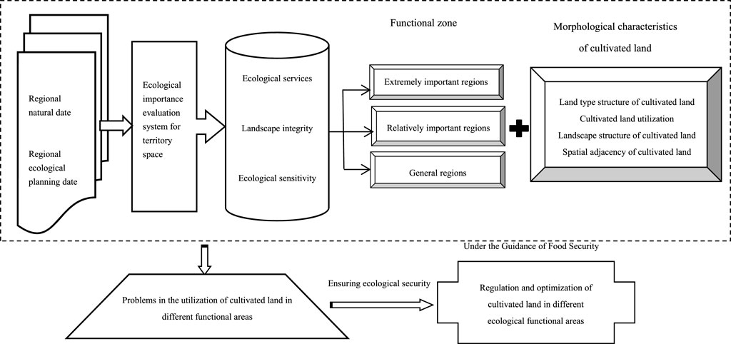
FIGURE 1. Framework of cultivated land consolidation in different ecological functional regions.
Ecological importance assessment of territorial space is the process of dividing regions into spatial units with different ecological functions based on the characteristics of regional ecosystems and the sensitivity of the ecological environment. This process involves systematically referring to existing research results on territorial space ecological security evaluations (Yu et al., 2009; Xie and Li, 2011; Guan et al., 2013; Guan et al., 2017; Fu, 2019), is based on the cognition of land ecosystem attributes, emphasizes the long-term stability of territorial space ecological security, gives full consideration to the representativeness of the indicators and the accessibility of the data by closely comparing them against the actual situation of the research area. Evaluation factors were selected from the aspects of ecological services, landscape integrity and ecological sensitivity, and an evaluation index system of territorial space ecological importance was scientifically constructed (Table 1).
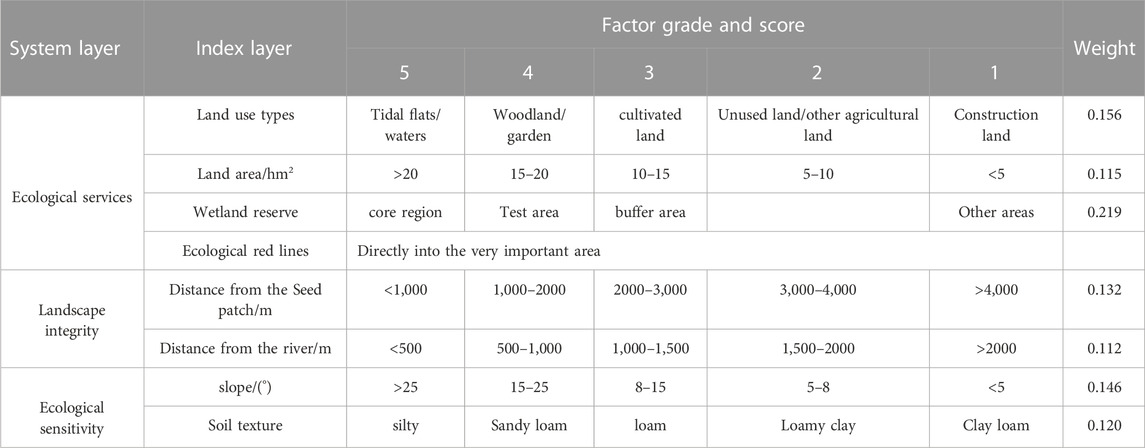
TABLE 1. Ecological importance evaluation system for territory space.
(1) Ecological services
Land use pattern changes affect ecological processes, which in turn affect ecosystem services that couple natural and social systems (Fu, 2019). The ecological importance of territorial space is closely related to the type of land use. The actual situation of the region is accurately understood, and water resource factors are regarded as the most rigid evaluation indices. The ecosystem service function of national space is related to plot area. The larger the area of a certain land use type is, the richer its biodiversity is and the stronger its anti-interference ability is. The smaller the plot area is, the weaker its ecological function is. Wetlands are known as the kidneys of the Earth. The published wetland conservation plan divides wetlands into core areas, pilot areas and buffer zones, and the evaluation score of the wetland reserve is determined according to the protection plan. The ecological red line plays a key role in maintaining the stability of the natural ecosystem and ensuring regional ecological security. Therefore, the land within the ecological red line is directly included as an extremely important area.
(2) Landscape integrity
The stability of the regional ecological structure and function can be realized only by maintaining the integrity of the ecosystem. Landscape integrity is an important indicator of territorial space ecological security. The mountains, water and wetlands constitute the main body of regional seed patches, which play an important role in maintaining the stability of the regional ecological structure. Rivers, as natural linear ecological structure elements, can effectively connect ecological patches to maintain the continuity of natural landscapes. Using GIS, regional seed patches and rivers are spatially buffered, and spatial values are assigned according to buffer distance to evaluate the integrity of the regional landscape structure.
(3) Ecological sensitivity
Ecological sensitivity refers to the degree of response of regional ecosystems to human disturbance and natural environmental changes. As the habitat of many microbial resources, soil itself has a buffering and filtering function. The more fragile the soil ecological environment is, the stronger the regional ecological sensitivity is. Based on an overall understanding of the regional natural situation and with reference to relevant studies (Xie and Li, 2011; Guan et al., 2013), the soil texture and topographic slope are combined to evaluate the regional ecological sensitivity.
Per the advice of multiple experts, the land parcel was determined to be a proper evaluation unit for index assignment and the analytic hierarchy process was used to determine the weight of the evaluation index (Table 1), and the ecological importance index of each land parcel was calculated through the comprehensive weighting model using the following formula:
The landscape pattern index of cultivated land is highly concentrated information of the spatial pattern of cultivated land, which can effectively reflect the structural composition and spatial morphological characteristics of cultivated land resources (Guan et al., 2013; Guan et al., 2017). After 10 m*10 m rasterization, the landscape pattern characteristics of cultivated land under different utilization modes were calculated using the landscape pattern analysis software Fragstats 4.2.
The function and structure of patches are closely related to their spatially adjacent patch types (Fu, 2019). By analyzing the characteristics of their spatially adjacent patches, the potential risks on the utilization form of target patches or the degree of influence of the surrounding land types can be effectively diagnosed. The characteristics of spatially adjacent cultivated land patches can be obtained by buffering and superposition cultivated land patches and global map patches.
Mengjin County is located in midwestern Henan Province at the geographical boundary of the middle and lower reaches of the Yellow River. Mangshan Mountain is a remnant of the Loess Plateau in midwestern Mengjin County, and the Yellow River terrace in the northeast is relatively flat (Figure 2). The highest altitude in the western mountain area is 471 m, and the lowest altitude on the eastern Yellow River beach is 120 m, which is 55.5 km long from east to west and 26.9 km wide from north to south, with a total area of 734.77 km2.
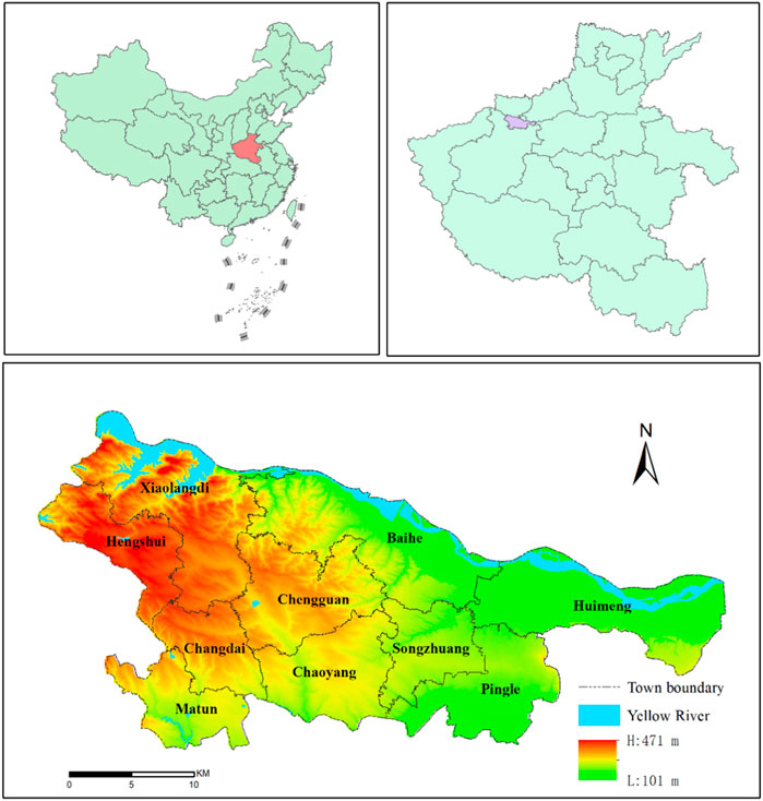
FIGURE 2. Location of the study area and the DEM of Mengjin Contry.
The Yellow River enters Mengjin from Xin’an County in the west and flows through the towns of Xiaolangdi, Baihe and Huimeng. Xiaolangdi Dam is located in the village of Xiaolangdi. The Xiaolangdi Reservoir covers a total area of 272 km2. The Xixiayuan Reservoir dam is located in the village of Xixiayuan. The Xixiayuan Reservoir is relatively open, with a total storage capacity of 145 million m3 and an average water depth of 4–6 m.
Mengjin County, as a typical county in the middle and lower reaches of the Yellow River, has a special geographical environment. Located in the northern part of the county are the Xiaolangdi Reservoir, Xixiayuan Reservoir and Yellow River channel. Since the operation of the Xiaolangdi Water Conservancy Project in July 2000, the main channel of the Yellow River has been controlled within a fixed channel, and the coastal tidal flat in the northeast of the county has changed from seasonal flooding to large-scale agricultural development, resulting in a continuous shrinkage of tidal flat wetlands. The influence of cultivated land development and utilization on regional ecological security was ignored. In the northwest is the loess gully region along the Xiaolangdi Reservoir, which is characterized by a steep topography, high field fragmentation, high ecological sensitivity and inconvenient farming. With the gradual attrition of the agricultural labor force, farming is frequently abandoned. The southern part of the county is adjacent to the urban area of Luoyang, and under the influence of urban expansion, high-quality agricultural space is constantly replaced by construction, which has creating some underlying concerns for food security production.
The land use data were obtained from three land survey databases provided by the Natural Resources Bureau of Mengjin County. Data on the ecological red line were obtained from the Natural Resources Bureau of Mengjin County. The water source and wetland protection regionalization data were from the Master Plan of Henan Yellow River Wetland National Nature Reserve (2012–2020). Digital Elevation Model (DEM) data and soil data were obtained from the Data Center of the Chinese Academy of Sciences (http://www.resdu.cn).
In terms of data processing, ArcGIS 10.2 was used to carry out unified spatial coordinate registration of the relevant vector data and to obtain basic data on the ecological importance evaluation of territorial space by spatial buffering of relevant evaluation indicators. Combined with the research needs, realistic characteristics of regional land use, and land use classification according to national spatial planning, land use data from 7 categories were included in the study area, including cultivated land (paddy fields, irrigated land, dry land), garden land (orchard, and other garden), forestland (arbor forestland, shrub land, other forestland), grassland (artificial grassland and other grass), other agricultural land (breeding pits, facilities, agricultural land, rural roads, pits or water), construction land (rural housing land, town/village roads, public facility land, science, education, culture and health land, special land, highway land, etc.), and unused land (river water surface, lake water surface, idle land, bare land, bare rock and gravel land, inland tidal flat, reservoir water surface), and a 10 m × 10 m rasterization treatment was performed.
The ecological importance of territorial space is reflected by the ecological importance index of territorial space. The higher the index is, the greater the ecological importance. The spatial ecological importance index of Mengjin County ranges from 1 to 4.333, and the natural fracture point method is adopted to divide the regional territorial space into extremely important regions (2.908–4.333), relatively important regions (2.001–2.908) and general regions (1–2.001).
As shown in Figure 3, the extremely important areas are mainly distributed in the Yellow River Valley along the Yellow River at the northern edge of Huimeng, Baihe and Xiaolangdi, with an area of 104.61 km2, accounting for approximately 14.24% of the county’s land area. The area belongs to the long and narrow valley terrace, there is a relatively flat terrain in the area, and the Yellow River serves as a very large ecological corridor. The Xiaolangdi Reservoir, Xixiayuan Reservoir, and the Yellow River wetland reserve effectively maintain the stability of the ecological structure, the regional landscape integrity is strong, the area is rich in biodiversity, the Yellow River Basin area maintains the water ecological security, and the area has an extremely important level of ecological importance.
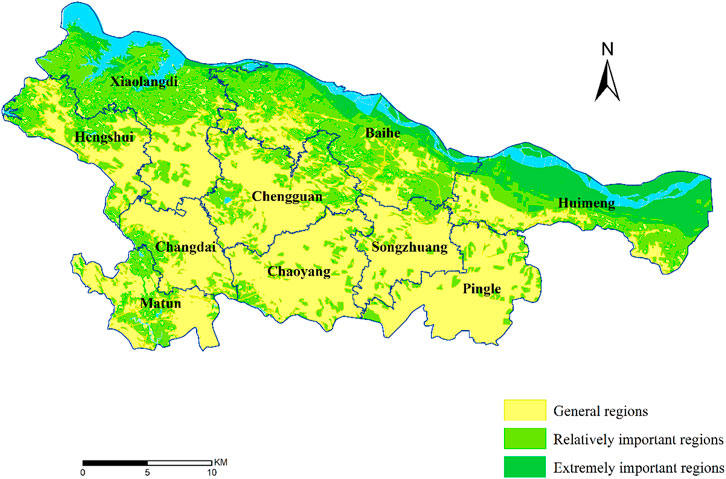
FIGURE 3. Spatial distribution of ecological importance within Mengjin County.
The relatively important areas are mainly distributed in southern Xiaolangdi, southern Baihe, southern Huimeng and western Hengshui on the periphery of the very important areas and are somewhat distributed in the towns of Changdai and Matun, with an area of 245.26 km2, accounting for 33.37% of the total land area. This region is a typical loess gully region with fragmented plots and a strong ecological sensitivity. Improper agricultural use easily causes soil and water loss. The land use in this region is based on forestland and cultivated land, and there are construction land patches with poor landscape integrity.
The general regions are mainly distributed in the towns of Chengguan, Chaoyang, Songzhuang and Pingle, with an area of 384.90 km2, accounting for approximately 52.38% of the county’s land area. These general regions make up the main body of Mengjin County’s land space. This area mostly has a gentle, hilly slope because the seasonal flow of the Chan River through the area leads to a lack of large habitat patches, the area of cultivated land and construction land being more mixed, landscape patches, a weak overall regional ecological service function, and a general level of ecological importance at the national scale.
The total cultivated land of Mengjin County is 29987.42 h m2, among which the paddy field area is 971.13 h m2, accounting for approximately 3.24% of the total cultivated land, which is mainly distributed along the Yellow River beach of the town of Huiming. The irrigated land area is 10166.5 h m2, accounting for 33.90% of the total cultivated land area, mainly distributed in Huimeng, Songzhuang, Chaoyang, Pingle and other towns. The dry land area is 18849.79 h m2, accounting for 62.86% of the total cultivated land area, mainly within Xiaolangdi, Hengshui, Changdai, Chengguan and other townships. The quality of cultivated land in Mengjin County as a whole is not high, and its distribution is shown in Figure 4.
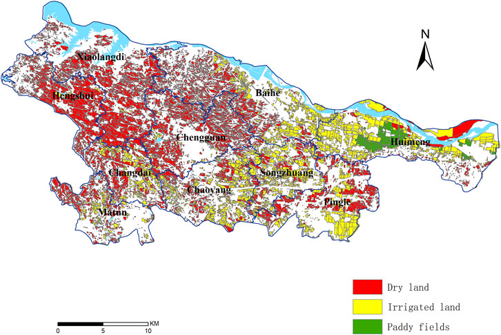
FIGURE 4. Spatial distribution of cultivated land use types in Mengjin County.
Because of the extremely important region near the Yellow River and the importance of the land along the river, the water resource conditions are relatively superior, with an ecologically extremely important paddy field area of 548.60 h m2, representing approximately 56.49% of the county’s area of paddy fields. Under the condition of limited water resources, rice cultivation has utilized a large amount of the region’s natural water source, which is also an important reason for the shrinkage of wetlands in the Yellow River beach area.
The relatively important region is on the outer area of the ecologically extremely important area, and its water resource condition is second only to the extremely important area. The paddy field area is 404.43 h m2, accounting for 41.64% of the paddy field area in the county. However, restricted by topographic conditions, the area of dry land in this region is 8363.96 h m2, accounting for approximately 73.01% of the area of cultivated land in ecologically important areas, and the basic conditions of agricultural production are relatively poor.
The general region is far from the Yellow River, and it is also the leading area of urban development in Mengjin County. Agricultural production in the area is limited by ecological factors, with a long history of agricultural development and a relatively perfect farmland infrastructure. The irrigated land area is 5462.88 h m2, accounting for 53.74% of the county’s irrigated land area, but there are certain terrain undulations in the area. The dryland area is also widely distributed (Table 2).
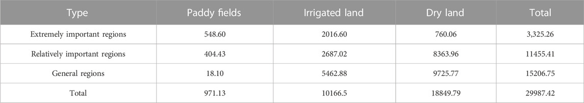
TABLE 2. Land type structure of cultivated land in different ecological function areas (hm2).
Therefore, water resources and topographic conditions are the basic factors affecting cultivated land utilization. Cultivated land regulation in Mengjin County should prioritize water saving, spatial balance and systematic management. On the basis of ensuring ecological security, microgeomorphic transformation should be actively implemented to continuously improve the utilization efficiency of water resources, reduce the proportion of dry land and systematically solve the objective constraints of congenital deficiency.
From the perspective of cultivated land utilization, there are five types of cultivated land utilization in Mengjin County, namely, arable land with rotation of grain and non-grain crops, cultivated land intercropped with forest and grain, abandoned arable land, cultivated land for growing nonfood crops, and arable land for growing food crops. The cultivated land without any grain production function is divided into two types, namely, abandoned arable land and cultivated land for growing nonfood crops. The area of abandoned arable land is 717.07 h m2, mainly distributed in the towns of Matun, Chaoyang and Pingle near the urban area of Luoyang in southern Mengjin. The cultivated land area for nonfood crops is 2135.68 h m2, mainly distributed in southern Xiaolangdi, eastern Baihe, western Huimeng and the central region of Songzhuang. The spatial distribution of cultivated land use in Mengjin County is shown in Figure 5.

FIGURE 5. Spatial distribution of cultivated land utilization in Mengjin County.
The rates of “non-grain” cultivated lands, which completely lack a food production function, are 7.66%, 8.93% and 10.38% in the extremely important, relatively important and general regions of Mengjin County, respectively.
Most of the cultivated land in the extremely important area is developed from the Yellow River tidal flat, with relatively flat terrain, sparse villages, and large average plot areas and wherein mechanized cultivation is convenient, which can realize the scale benefit of grain cultivation to a certain extent. Therefore, the degree of non-grain conversion of cultivated land in the extremely important area is relatively low. Some of the cultivated land in the important area is restricted by the terrain, the farmland facilities are not perfect, mechanical operation is inconvenient, and the benefits of planting food crops are generally low; in those areas, some farmers adapt by cultivating vegetables, medicinal materials, forest fruits and other cash crops, and most of the farmers improve their economic benefits of agricultural production through grain and non-grain crop rotation. The area of arable land with a rotation of grain and non-grain crops in this region is 366.02 h m2, accounting for approximately 52.13% of the total grain and non-grain rotation areas in the county.
In general, in areas affected by urban industrialization, cultivated land is constantly being converted into construction land, and some farmers convert their cultivated land into facilities for growing flowers or sightseeing destinations to maintain their operating profits. Due to the large number of opportunities for nonagricultural labor, many farmers are also induced to convert their cultivated land to forestland or completely give up cultivation and utilization of their land. The area of abandoned arable land in this region is 480.54 h m2, accounting for 67.01% of the uncultivated land area in the county, as shown in Table 3.
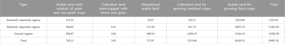
TABLE 3. Utilization of cultivated land in different ecological function areas in Mengjin County (hm2).
Therefore, accelerating the mechanization transformation of hilly and mountainous farmland, supporting the construction of grain processing facilities, extending the industrial chain, implementing large-scale and brand projects, and improving grain management benefits are important ways to reduce the non-grain conversion rate of cultivated land.
Due to the influence of topography and tillage patterns, there are great differences in the spatial structure and distribution form of cultivated land in different ecological function areas. The landscape pattern index could effectively reflect the detailed differences in cultivated land use form in different ecological function areas. The number of patches (NP) and average patch AREA (area-MN) are selected to characterize the patch size in Fragstats 4.2. Patch dispersion is characterized by ENN-MN and AI, and patch density (PD) and the landscape shape index (LSI) are used to characterize patch complexity.
As extremely important regions account for only 14.24% of the county’s land area, there are only 491 cultivated patches in ecologically important areas. Most of the cultivated land in the extremely important regions is developed from tidal flats. The average scale of the farmlands is large, and the shapes of the farmlands are relatively regular. Historically, few rural settlements have been sited in tidal areas, so the degree of concentration of farmland patches is relatively high.
The general regions area concentrated in the urban development area in Mengjin County. The cultivated land in the area is very fragmented by villages and roadways. As villages are developed, the cultivated land patches are constantly being fragmented and usurped by construction land, and the landscape shape index of cultivated land patches becomes more complex. The relatively important regions are in the transition zone between the extremely important regions and the general regions, and the cultivated land landscape pattern index in this region has an intermediate value. In addition, because the Yellow River channel passes through the ecologically important area, the cultivated land in the ecologically important area is distributed on both sides of the Yellow River, resulting in the maximum average nearest distance (ENN-MN) of the cultivated land patches in the ecologically important area, as shown in Table 4.
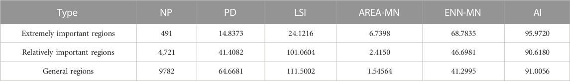
TABLE 4. Landscape pattern index of cultivated land with different ecological functions in Mengjin County.
The landscape pattern index of cultivated land reflects the overall spatial characteristics of cultivated land use in the region. Land consolidation in the main grain-producing areas should reduce the discreteness and complexity of cultivated land patches as much as possible and improve the scale efficiency of cultivated land use through consolidation. Land consolidation in urban development areas should be combined with urban landscape construction to improve the compound function of cultivated land. In the ecological core area, human disturbance should be reduced as much as possible to maintain the integrity of the natural landscape.
The spatial adjacency features of the patches can be used to explore spatially dependent paths, interaction intensity, and symbiotic or causal patterns between patches from massive amounts of spatial data. The higher the contiguous ratio between the patches and a certain land type, the stronger the correlation between the patches and the land type. If the contiguous ratio between a certain land type and the cultivated land is higher than 50%, it means that most of the cultivated land is surrounded by that land type, and it also indicates that the land lot and the cultivated land have a high possibility of conversion.
In the extremely important regions, the two land types with the largest contiguous proportions of cultivated land are other agricultural land and forestland because most of the cultivated land in this area is developed from the beach area, and there are a large number of pits and breeding ponds in the low-lying, cultivated land areas of the beach area. In addition, there is a large amount of unused land area in the beach area, a large amount of shrub land is distributed around the unused land, resulting in other agricultural land, and forestland is the largest adjacent land category of the cultivated land in this region.
In the relatively important regions, the two types of adjacent arable lands with the largest proportions are forestland and other agricultural land. This is because relatively important regions are traditionally agricultural production areas. When the benefit of grain planting is low, it is common for farmers to convert arable land to agricultural facility land. Farmers also convert farmland to forestland more often, resulting in a high proportion of farmland adjacent to forestland and other agricultural land.
The general regions are the core area of urban spatial development, where all kinds of construction land and cultivated land are interlaced. Under the guidance of a large-scale territorial space greening policy, a large number of landscape forest belts are planted on both sides of the main roadways, resulting in a high proportion of cultivated land, forestland and construction land adjacent to this area, as shown in Table 5. It can be known that the policy coordination between management departments is an important way to prevent disordered non-food.
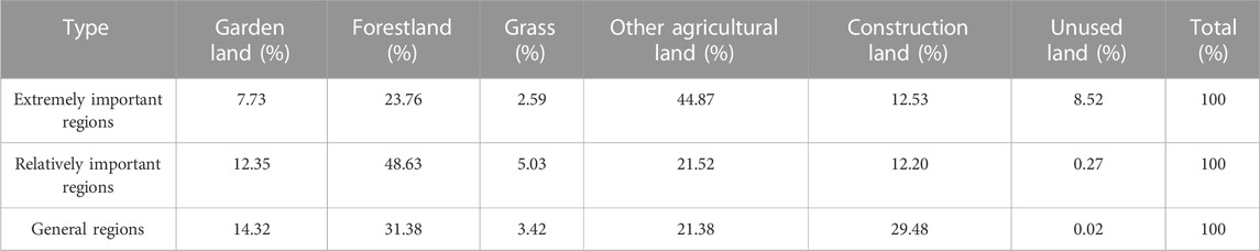
TABLE 5. Spatial adjacency of cultivated land in different ecological function zones in Mengjin County.
The spatial adjacency characteristics of the patches are important indicators of suitability for a certain land type. If the cultivated land is adjacent to wetland shrubs and the adjacent boundary is greater than 50%, it is feasible to restore the plot to wetland shrubs. Similarly, if the degree of adjacency between cultivated land patches and other agricultural land exceeds 50%, it means that the reclamation of other land interspersed in the cultivated land is also highly feasible. Therefore, in the process of land consolidation, on the premise of ensuring ecological security, some of the other fine patches within the cultivated land can be converted to cultivated land to reduce the degree of fragmentation of cultivated land and improve the scale efficiency of cultivated land use.
At present, cultivated land utilization in Mengjin County is faced with dual challenges of an increasing degree of “non-grain” cultivation and increasing environmental risks. Guided by the goal of food security, cultivated land regulation in Mengjin County needs to systematically balance production, living and ecological needs by combining the dominant land uses and socioeconomic bases of the region and building a distinct Yellow River ecological system through differentiated cultivated land optimization and regulation to enhance the combined effects of the national Yellow River ecological strategy.
The total area of cultivated land in the extremely important region is 3,325.26 h m2, accounting for 31.79% of the total area of the extremely important regions. The long-term and large-scale development of the beach area of the Yellow River leads to a sharp reduction in riverside wetlands and the destruction of natural vegetation and bird habitats. Especially after the tidal flat is transformed into cultivated land, improper agricultural utilization brings nonpoint source pollution to the Yellow River tidal area, and the regional ecological function seriously conflicts with the regional land use. Guided by the goal of food security, development of wetlands in the region should be strictly controlled, and the existing cultivated land should be “balanced”, “recyclable” and “diversified".
Regional cultivated land regulation scheme: Aiming at serving the ecological security of the Yellow River Basin, the development of unused land in the beach area is prohibited, and the ecological service of cultivated land in the beach area is comprehensively improved through comprehensive regulation. The ecological function restoration of the Yellow River tidal area is considered the ultimate goal of regulation and utilization, and the ecological red line is considered the rigid constraint condition. The ecological tillage of 2210.91 h m2 of cultivated land within the ecological red line is implemented, and the use of chemical fertilizers and pesticides is prohibited. The management of transit power lines is conducted underground, suitable environmental habitats are promoted, and transit power lines to the Yellow River wetlands are reduced to limit disturbance to waterfowl activities.
The total area of cultivated land in the relatively important regions is 11455.41 h m2, accounting for 46.71% of the total area of most important areas.
As a traditional main grain production area, this region has a limited cultivated land base, a high proportion of dry land area, many restrictions on large-scale utilization of the cultivated land, and a weak regional industrial foundation. Under the effect of the urban siphon effect, the long-term single population flow results in frequent cultivated land abandonment. Under the guidance of the goal of food security, comprehensive land consolidation should be carried out to reduce the “non-grain” and “abandoned” use of cultivated land and build high-quality and efficient core areas of grain production.
Regional cultivated land regulation scheme: With the goal of building a core area of regional grain production, the grain production function of “non-grain” and “abandoned” cultivated lands will be fully restored, and 211.56 h m2 of cultivated land will be prioritized for restoration to grain cultivation. In hilly areas, it is necessary to strengthen the improvement of cultivated land with good natural background conditions but that are inconvenient for cultivation and systematically support farmland infrastructure to lay the foundation for the use of labor-saving machinery and reduce the risk of the cultivated land being marginalized. In plain areas, the reclamation of inefficient construction land should be strengthened, and the adjustment of land ownership should be followed up on according to the transfer of the labor force to actively promote farmland consolidation and create conditions for large-scale farmland construction.
The total area of cultivated land in the general area is 15206.75 h m2, accounting for 39.51% of the total general areas. The urban development and agricultural production spaces in the region are highly superimposed. The cultivated lands near the Luoyang urban area and the Mengjin central urban area are fragmented by construction land, and the proportion of “non-food” use of cultivated land is high. Under the guidance of the national land greening policy, the cultivated land along the roadways is adjusted to forest landscapes on a large scale. Abandonment of cultivated land is more common. Under the guidance of food security goals, we should promote the organic integration of the landscape and production functions of cultivated land through comprehensive land consolidation and improve the food production function of cultivated land.
Regional cultivated land regulation plan: Fully abiding by the principle of matching rural production activities with landscape value and function orientation, promote the composite utilization of cultivated land, and prioritize the restoration of 480.54 h m2 of abandoned arable land to grain use. In the urban and rural interleaving farmland area, it is necessary to continuously expand spaces for leisure and sightseeing of beautiful farmlands, comprehensively improve the farming experience, ecological conservation, tourism and leisure and other diversified living functions of cultivated land, and promote the transformation of abandoned farmland to “shared farmland” and “shared manors” based on a socialization platform in accordance with the concepts of advancement and replacement to restore the food production function of cultivated land. In addition, the efficiency of resource utilization should be improved. In the farmland area outside the town, around the construction of a beautiful countryside, the cultivation of “high quality, high yield and high efficiency” farmland should be strengthened.
Due to the influence of land greening policies, it is common to convert cultivated land to forestland around towns and on both sides of roadways, thus increasing the amount of “non-grain” cultivated land. If the land that has been transformed into forestland is adjusted and restored to arable land, it will not only waste a large amount of funds but also cause damage to the ecological environment to a certain extent.
Therefore, under the goal of food security, the primary goal of land consolidation in Mengjin County is to reduce the non-grain rate of cultivated land. Through land consolidation and land ownership adjustment, the restoration of abandoned cultivated land in general ecological areas and in more important ecological areas for grain use and delaying the marginalization process of cultivated land should be prioritized. In this way, the food supply capacity can be maximally enhanced, and the basic interests of farmers can be maintained without causing damage to the ecological environment.
The dietary structure of people in urban and rural residential areas shows a trend of a reduced proportion of main grains and increased diversification. Therefore, under the guidance of food security goals, the concepts of “big agriculture” and “big food” should be established. These should not only meet people’s total energetic intake demand but also meet the increasingly diversified food consumption demand and improve the food security ability in a multidimensional way. Therefore, it is necessary to recognize how much “non-food” cultivated land is reasonable, allow a reasonable “food” use of cultivated land, strictly forbid the structural adjustment of cultivated land to “nonfood” purposes, and resolutely prevent the conversion of cultivated land to forestland and landscapes.
It is important to promote the modernization of farmland management systems to promote the coordinated energy efficiency of farmland protection management. In the past, the relevant state departments lacked a systematic understanding of ecological civilization construction and believed that increasing the forest coverage rate was a good policy for promoting ecological civilization construction. Through governments at all levels, large-scale greening projects were implemented on both sides of expressways, national roads, provincial roads and even county roads that helped to promote “non-grain” cultivated land to a certain extent. Policy coordination among departments, therefore, focuses on the local-scale governance of marginalized farmland recovery, mainly on policies at a regional scale, through the promotion of a regional ecological function in coordination with a food safety supply regulation mode, realizing the organic combination of ecology and the industrial chain.
A total of 66.48% of the cultivated land in the extremely important region is within the ecological red line. With its large scale, high degree of mechanization and low proportion of non-grain production, the cultivated land in the beach area is the production area of high-quality agricultural products in Mengjin County. If all the cultivated land is withdrawn from use, it will inevitably have an adverse impact on food safety production and a great impact on the livelihood of regional farmers.
Therefore, ecological farming in beach areas is an important way to resolve the conflicts between food safety production and ecological environment protection. Strict implementation of ecological farming in beach areas requires the allocation of corresponding planting structures according to the site conditions of the region and the reduction of human interference to the greatest extent through systematic control.
Income is an important factor affecting whether farmers adopt ecological farming. Therefore, in the near future, some suitable plots can be transformed into lotus ponds or fish ponds with wetland functions, and ecological tourism based on wetland bird watching, lotus pond rafting and fish pond fishing can make up for part of the loss of ecological farming. Under current farming conditions, most farmers tend to use chemical fertilizers and pesticides to maintain stable farming benefits, and corresponding control policies are needed to promote ecological farming in beach areas. To maximize the value of ecological agricultural products, we need to rely on the regionalization of agricultural distribution, the scale of operation, and the industrialization of products and overcome the value loss caused by ecological farming with standardized management.
(1) Guided by the goal of food security, the regulation and control of cultivated land in different ecological function zones in Mengjin County should fully connect with the national Yellow River Strategy and be carried out in different zones and categories based on the regional ecological red line, farmers’ development needs and the difficulty of making changes.
In the extremely important regions, the restoration of the ecological function of the Yellow River beach should be the ultimate goal of regulation and utilization, ecological farming of the beach land should be implemented, development of the beach wetland should be strictly controlled, and human disturbance should be reduced. In the relatively important regions, we should make full use of the existing cultivated land to ensure that more land does not become abandoned. Land consolidation should be strengthened, farmland infrastructure should be systemically supported, and combined with the adjustment of farmland ownership, and land consolidation should be actively promoted to create conditions for large-scale farmland construction. In the general regions, the principle of matching rural production activities with landscape value and function orientation should be fully observed, and the composite utilization of cultivated land should be promoted.
In the face of the surging consumption of high-end agricultural products, we should expand the space for leisure and beautiful agricultural land and promote the construction of “shared farmland” and “shared manors” in a timely way, promote the high-quality integrated development of urban and rural areas, pay attention to the landscape construction of large-scale farmland, and establish a more reliable food security base. This regulation scheme can guarantee grain safety production to the greatest extent and effectively enlarge the ecological and environmental effects of land consolidation.
(2)The low economic benefit is an important reason for the “non-grain” of cultivated land. However, due to the significant difference in production efficiency between non-grain crops and grain crops, farmers with a larger scale of land management prefer to plant grain crops. In the ecologically extremely important regions, uncultivated land is small and scattered, so it should be guided to implement “rewilding” utilization of uncultivated land in this regions. In ecologically relatively important regions, land transfer should be actively guided for uncultivated land, and large-scale and brand-oriented projects should be implemented through machine-oriented transformation of farmland in hills and mountains to comprehensively improve the scale benefits of non-grain planting. For cultivated land planted with vegetables and medicinal materials, industrial layout planning should be further improved to strengthen the agglomeration effect of cash crop planting. In the ecological general regions, the abandoned farmland should be restored for food use by developing substitute farming or sharing and experiential agriculture. For the cultivated land planted with flowers and nurseries in the region, we should actively develop water-saving urban agriculture and improve the water efficiency of facility agriculture.
(3)With the government’s increasing focus on the ecological protection of the Yellow River basin, most of the tidal flats along the Yellow River have been included in the ecological red line. However, due to the disordered development of tidal flats throughout history, there is a large area of cultivated land in the tidal area of the Yellow River, resulting in the conflict between ecological protection and food production. The Mengjin beach area is only a small part of the Yellow River beach area; if the Yellow River beach area is blindly restored into farmland, it will have a certain impact on the national food security supply; therefore, the implementation of ecological farming is an important way to solve the ecological protection and food security production. Currently, the compilation of national spatial planning should reflect the requirements of the national spatial development strategy, coordinate the relationship between food security, ecological civilization and sustainable development, use the consistency of national spatial management and control as guidance, reasonably delimit ecological, urban construction and agricultural development spaces, and optimize the management and control mode of spatial resources. This will ensure that the results of territorial space planning are forward-looking and scientific, improve the effectiveness of the work of relevant government administrative departments, and reduce the contradiction between multiple plans and joint management.
(4)The ecological red line is an important system for ecological environmental protection in China. In the process of delineating the ecological red line, the competent authorities often include the important, sensitive and vulnerable territorial space within the region into the red line, so as to maintain the basic ecosystem structure and function. In the arid and semi-arid areas of central and western China, most rivers, lakes and reservoirs and their surrounding areas are included in the ecological red line and strictly controlled, resulting in the dilemma of excellent agricultural conditions and shortage of irrigation water. How to support national food security and maintain the healthy development of ecological environment with limited water resources? It is one of the bottleneck problems that need to be solved urgently. The ecological red line is not a barrier to the tension between man and nature, nor is it a universal line to solve ecological problems. To establish an ecological civilization in which human beings coexist in harmony with nature, water resources should be regarded as the biggest rigid constraint. Under the premise of comprehensively considering the requirements of national food security, factors such as water resources conditions, farmland output capacity, irrigation capacity and level should be fully considered to scientifically determine the grain output of the basin and follow the concept of ecosystem services. In order to ensure that the withdrawn irrigation water plays its role in ecological protection, it is necessary to strictly control the expansion of irrigation area, introduce or improve relevant policies and measures, and promote the coordination of various functional departments in agricultural water-saving and ecological protection.
Based on the dominant space and social and economic basis of cultivated land in different ecological functional areas, this study systematically balanced people’s demands for production, living and ecological functions of cultivated land in different locations, took the safe supply of food as the target, and comprehensively considered the multifunctionality of cultivated land utilization, and proposed the remediation and optimization regulation paths of cultivated land in different ecological functional areas. This study improves the result instability caused by selecting cultivated land function evaluation index to measure cultivated land multifunction and function balancing. It enriched the research system of cultivated land multifunction, and provided a scientific basis for optimizing and adjusting the relationship of cultivated land multifunction according to local conditions under the guidance of food security goals.
Based on the conclusion of this study, the following policy suggestions are put forward: ① The cultivated land within the ecological red line should take into account ecological protection and agricultural production issues, avoid “one-size-fits-all”, implement the management mechanism of “functional zoning + control rules”, clearly prohibit the use of pesticides and fertilizers, and the cultivated land management system oriented by leading functions is fully implemented. ② To establish a comprehensive view of big food, we should acknowledge the practical needs of food diversification. The “non-grain” prevention and control of cultivated land is mainly to control the abandonment of farmland and planting trees, so as to avoid excessive adjustment to the direction of grain and harm to the vital interests of farmers.③ The policy in-coordination between management departments is also an important reason for the cultivated land “non-grain”, large-scale greening projects have caused the high-quality cultivated land along the traffic line to be adjusted to forest land, and the policy coordination between management departments is the basic condition to ensure the management of cultivated land “non-grain”. ④ The future land consolidation work should change the previous tendency of paying too much attention to improving the quality of cultivated land, and the focus of work should be shifted to ownership adjustment, through which large-scale cultivation of cultivated land should be promoted. At the same time, the overall policy of land allocation by water should be implemented. All irrigated farmland should be reformed for efficient water saving, and the development scale of irrigated area should be strictly controlled to achieve both water saving and efficiency improvement.
The original contributions presented in the study are included in the article/Supplementary Material, further inquiries can be directed to the corresponding author.
In this paper, XG processed the data and wrote the main contents of the paper. XW, JZ, and ZD provided ideas for the paper. All authors contributed to the article and approved the submitted version.
This work was supported by the National Natural Science Foundation of China (Grant No. 42101309), Humanities and Social Science Project of Ministry of Education (Grant No. 20YJCZH037), Henan Provincial Scientific and Technological Innovation Talents Support Program (Grant No. 2021-CX-052), Philosophy and Social Science Planning Project of Henan Province (Grant No. 2022BJJ110) and Key Project of Fundamental Research of Philosophy and Social Sciences in Universities of Henan Province (Grant No. 2023-JCZD-21).
The authors declare that the research was conducted in the absence of any commercial or financial relationships that could be construed as a potential conflict of interest.
All claims expressed in this article are solely those of the authors and do not necessarily represent those of their affiliated organizations, or those of the publisher, the editors and the reviewers. Any product that may be evaluated in this article, or claim that may be made by its manufacturer, is not guaranteed or endorsed by the publisher.
Blum, W, E, H., Warkentin, B, P., and Frossard, E. (2006). Soil, human society and the environment. London, England: Geological Society London Special Publications. doi:10.1144/GSL.SP.2006.266.01.01
Cheng, X., Chen, M., Lai, Z., and Xiao, S. (2023). Spatial differentiation pattern and correlation factors of “non-grain” cultivated land in mountainous counties. Trans. Chin. Soc. Agric. Eng. Trans. CSAE) 39 (2), 203–211. doi:10.11975/j.issn.1002-6819.202209269
Coyle, C., Creamer, R, E., Schulte, R, P, O., Sullivan, O, L., and Jordan, P. (2016). A Functional Land Management conceptual framework under soil drainage and land use scenarios. Environ. Sci. Policy 56, 39–48. doi:10.1016/j.envsci.2015.10.012
Feng, D., Liu, J., Shan, W., and Jin, X. (2019). Preliminary study on connotation extension and management mode of multi-functional and compound cultivated land protection. J. Land Econ. 1, 149–164.
Fu, B. (2019). Land resources system cognition and land ecological security pattern. China Land 12, 9–11. doi:10.13816/j.cnki.ISSN1002-9729.2019.12.03
Gao, H., Chen, W., and Yun, W. (2018). Discussion on cultivated land health and its management. China Land 12, 23–25. doi:10.13816/j.cnki.cn11-1351/f.2018.12.006
Guan, X., Wang, X., and Chen, W. (2022). Risk assessment and regulation strategy of farmland marginalization: A case study of Mengjin county, henan Province. Front. Environ. Sci. 10, 892665. doi:10.3389/fenvs.2022.892665
Guan, X., Wang, X., and Chen, W. (2020). Risk evaluation and verification of marginalization of farmland in county area. Trans. Chin. Soc. Agric. Mach. 2, 153–160. doi:10.6041/j.issn.1000-1298.2020.02.017
Guan, X., Wang, X., Zhang, F., Jiang, G., and Li, L. (2017). Rehabilitation and adjustment of rural residences in mountainous areas under rigid ecological constraints. Resour. Sci. 2, 220–230. doi:10.18402/resci.2017.02.05
Guan, X., Wang, X., and Zhao, Y. (2021). Morphological characteristics identification and optimization of “non-grain” cultivated land along Yellow River Basin. Trans. Chin. Soc. Agric. Mach. 10, 233–242. doi:10.6041/j.issn.1000-1298.2021.10.024
Guan, X., Zhang, F., Wang, X., Zhao, H., and Jiang, G. (2013). Spatial evolution of urban ecological land and its distribution optimization in Beijing. Areal Res. Dev. 3, 119–124. doi:10.3969/j.issn.1003-2363.2013.03.023
Guo, B., Jin, X., Yang, X., Guan, X., Lin, Y., and Zhou, Y. (2015). Determining the effects of land consolidation on the multifunctionlity of the cropland production system in China using a SPA-fuzzy assessment model. Eur. J. Agron. 63, 12–26. doi:10.1016/j.eja.2014.11.002
Jiang, G., Zhang, F., Kong, X., Zhao, H., and Zhou, D. (2011). Toxicological assessment of TiO2 nanoparticles by recombinant Escherichia coli bacteria. China Land Sci. 8, 42–48. doi:10.1039/c0em00499e
Kong, X. (2020). It is necessary to improve the collaborative management ability to prevent the "non-agricultural" of cultivated land. Chin. Cadres Trib. 10, 81–82. doi:10.14117/j.cnki.cn11-3331/d.2022.02.016
Kong, X., Zhang, B., Wen, L., Hu, Y., Lei, M., Yao, J., et al. (2018). Theoretical framework and research trends of cultivated land quality based on elements-process-function. China Land Sci. 9, 14–20. doi:10.11994/zgtdkx.20180824.095352
Li, G., Lu, K., and Huang, L. (2017). Reflection and reconstruction of cultivated land conversion value loss compensation under the subject rights. China Popul. Resour. Environ. 12, 137–145.
Liu, C., Xu, Y., Huang, A., Liu, Y., Wang, H., Lu, L., et al. (2018). Spatial identification of land use multifunctionality at grid scale in farming-pastoral area: A case study of zhangjiakou city, China. Habitat Int. 76, 48–61. doi:10.1016/j.habitatint.2018.05.010
Liu, H., Bi, R., Guo, Y., and Wang, J. (2021). Protection zoning of cultivated land based on form-structure-function multidimensional evaluation system. Trans. Chin. Soc. Agric. Mach. 2, 168–177. doi:10.6041/j.issn.1000-1298.2021.02.015
Liu, L., Zhou, D., Chang, X., and Lin, Z. (2020). A new grading system for evaluating China's cultivated land quality. Land Degrad. Dev. 31, 1482–1501. doi:10.1002/ldr.3547
Lu, X., Zhang, Y., and Zou, Y. (2021). Evaluation the effect of cultivated land protection policies based on the cloud model: A case study of xingning, China. Ecol. Indic. 131, 108247. doi:10.1016/j.ecolind.2021.108247
Lv, X., Niu, S., Gu, G., and Peng, W. (2020). Conceptual cognition and research framework on sustainable intensification of cultivated land use in China from the perspective of the "New Agriculture, Countryside and Peasants. J. Nat. Resour. 9, 2029–2043. doi:10.31497/zrzyxb.20200901
Qian, F., Chi, Y., and Lal, R. (2020). Spatiotemporal characteristics analysis of multifunctional cultivated land: A case-study in shenyang, northeast China. Land Degrad. &Development 31 (14), 1812–1822. doi:10.1002/ldr.3576
Shi, Y., Zhao, H., Yun, W., Tang, H., and Xu, Y. (2015). Analysis on spatial differentiation of arable land multifunction and socio-economic coordination model in Beijing. Resour. Sci. 2, 247–257.
Song, X., and Ou, Y. (2012). Connotation of multifunctional cultivated land and its implications for cultivated land protection. Prog. Geogr. 7, 859–868. doi:10.11820/dlkxjz.2012.07.004
Song, Z., and Liu, L. (2011). Spatial characteristics analysis for multifunctional transition of suburban agricultural areas in beijing. Sci. Geogr. Sin. 4, 427–433. doi:10.13249/j.cnki.sgs.2011.04.004
Su, Y., Qian, K., Lin, L., Wang, K., Guan, T., and Gan, M. (2020). Identifying the driving forces of non-grain production expansion in rural China and its implications for policies on cultivated land protection. Land Use Policy 92, 104435. doi:10.1016/j.landusepol.2019.104435
Sun, R., Jin, X., Zhao, Q., Han, B., Zhang, X., Li, H., et al. (2020). IL23 induces IL23R recycling and amplifies innate receptor-induced signalling and cytokines in human macrophages, and the IBD-protective IL23R R381Q variant modulates these outcomes. Trans. CSAE 7, 264–273. doi:10.1136/gutjnl-2018-316830
Tang, J., Wei, X., and Dai, J. (2020). The choice of differentiated cultivated land protection policies from the perspective of territorial space. China Land 8, 4–9. doi:10.13816/j.cnki.ISSN1002-9729.2020.08.02
Vander, P, J, D., Laurent, C., Blondeau, F., and Bonnafous, P. (2009). Farm diversity, classification schemes and multifunctionality. J. Environ. Manag. 90, S124–S131. doi:10.1016/j.jenvman.2008.11.022
Wang, C., Peng, Q., Tang, N., Li, H., and Ling, W. H., (2018). Spatio-temporal evolution and the synergy and trade-off relationship of cultivated land multi-function in 2005-2015: A case of shapingba district, chongqing city. Sci. Geogr. Sin. 4, 590–598. doi:10.1017/S0007114517003932
Wang, G., and Hou, S. (2021). Ensuring China’s food security in the global COVID-19 crisis: Contradictions and resolutions. J. Xinjiang Normal Univ. (Philosophy Soc. Sci. 1, 120–133. doi:10.14100/j.cnki.65-1039/g4.20200722.001
Wang, R., Zhao, X., Zhao, L., Guo, X., Guo, J., Kuang, L., et al. (2022). STAT3-NAV2 axis as a new therapeutic target for rheumatoid arthritis via activating SSH1L/Cofilin-1 signaling pathway. Trans. Chin. Soc. Agric. Eng. Trans. CSAE) 38 (20), 209–219. doi:10.1038/s41392-022-01050-7
Wei, H., Luo, M., Wu, K., and Chen, T. (2021). Ecological risk assessment of heavy metal pollution in cultivated soil at typical county level in yangtze river delta. Trans. Chin. Soc. Agric. Mach. 52 (11), 200–209. doi:10.6041/j.issn.1000-1298.2021.11.021
Wei, J., Chen, X., Wu, Y., Han, X., Ling, L., and Zhang, L. (2023). Analysis of the spatial and temporal evolution of arable land denudation in the northwest drylands –A case study of DA LI, Shanxi Province. Chin. J. Agric. Resour. Regional Plan. 44 (3), 24–34. doi:10.7621/cjarrp.1005-9121.20230403
Wen, L., Kong, X., Xin, Y., and Sun, X. (2019a). Evolution of cultivated land quality connotation and its recognition. J. china Agric. Univ. 3, 156–164. doi:10.11841/j.issn.1007-4333.2019.03.19
Wen, L., Zhang, Q., Kong, X., Zhang, B., Yun, W., Sun, X., et al. (2019b). Arable land consolidation zoning based on comprehensive evaluation of capacity and health. Trans. CSAE 22, 79–89. doi:10.11975/j.issn.1002-6819.2019.22.009
Wilson, G, A. (2008). From‘weak’to‘strong’multifunctionality: Conceptualising farm-level multifunctional transitional pathways. J. Rural Stud. 24, 367–383. doi:10.1016/j.jrurstud.2007.12.010
Xie, H., and Li, X. (2011). Spatial assessment and zoning regulations of ecological importance based on GIS for rural habitation in Changgang Town Xinguo County. Acta Ecol. Sin. 1, 230–238. doi:10.3321/j.issn:1000-0933.2008.10.048
Xin, Y., Kong, X., and Yun, W. (2017). Design and application of multi-functional evaluation index system for cultivated land in metropolitan fringe of Beijing: A case study in daxing district. China Land Sci. 8, 77–87. doi:10.11994/zgtdkx.20170831.151622
Xiong, C., Zhang, Y., Wang, Y., Luan, Q., and Liu, X. (2021). Multi-function evaluation and zoning control of cultivated land in China. China Land Sci. 35 (10), 104–114. doi:10.11994/zgtdkx.20210916.155106
Yang, Q., and Zhang, D. (2021). The influence of agricultural industrial policy on non-grain production of cultivated land: A case study of the "one village, one product" strategy implemented in guanzhong plain of China. Land Use Policy 108, 105579. doi:10.1016/j.landusepol.2021.105579
Yang, X., and Tan, M. (2014). Changes and relationships of arable land functions in Beijing in recent years. J. Nat. Resour. 5, 733–743. doi:10.11849/zrzyxb.2014.05.001
Yang, Y., Wang, X., Wang, J., Geng, Y., Chen, W., Wu, Q., et al. (2022). Evaluation and improvement of cultivated land leisure service function based on multisource spatial data. Land 11, 303. doi:10.3390/land11020303
Ye, s., Song, C., Kuzyakov, Y., Cheng, F., Kong, X., Feng, Z., et al. (2022). Preface: Arable land quality: Observation, estimation, optimization, and application. Land 11 (6), 947. doi:10.3390/land11060947
Yu, K., Wang, S., Li, D., and Li, C. (2009). The function of ecological security patterns as an urban growth framework in Beijing. Acta Ecol. Sin. 3, 1189–1204. doi:10.3321/j.issn:1000-0933.2009.03.015
Zasada, I. (2011). Multifunctional peri-urban agriculture—a review of societal demands and the provision of goods and services by farming. Land Use Policy 28, 639–648. doi:10.1016/j.landusepol.2011.01.008
Zhang, X., Wu, K., Yang, Q., and Li, X. (2020). Progress on connotation and evaluation index system of cultivated land healthy productivity. Chin. J. Soil Sci. 1, 245–252. doi:10.19336/j.cnki.trtb.2020.01.34
Zhang, Y., Long, H., Ma, L., Ge, D., Tu, S., and Qu, Y. (2018). Farmland function evolution in the Huang-Huai-Hai Plain: Processes, patterns and mechanisms. J. Geogr. Sci. 28 (6), 759–777. doi:10.1007/s11442-018-1503-z
Zhao, X., Zhou, Z., Zhu, M., Wang, L., and Wu, Y. (2020). Research on ecological risk of Karst rocky desertification cultivated land based on landscape pattern. Res. Soil Water Conservation 6, 362–369. doi:10.13869/j.cnki.rswc.2020.06.047
Zhou, Y., Li, X., and Liu, Y. (2021). Cultivated land protection and rational use in China. Land use policy 106, 105454. doi:10.1016/j.landusepol.2021.105454
Keywords: cultivated land, food security, ecological security, regulation, Mengjin
Citation: Guan X, Wang X, Zhang J and Dai Z (2023) Regulation and optimization of cultivated land in different ecological function areas under the guidance of food security goals-a case study of Mengjin County, Henan Province, China. Front. Environ. Sci. 11:1115640. doi: 10.3389/fenvs.2023.1115640
Received: 04 December 2022; Accepted: 03 August 2023;
Published: 21 August 2023.
Edited by:
Xiangbin Kong, China Agricultural University, ChinaReviewed by:
Bangbang Zhang, Northwest A&F University, ChinaCopyright © 2023 Guan, Wang, Zhang and Dai. This is an open-access article distributed under the terms of the Creative Commons Attribution License (CC BY). The use, distribution or reproduction in other forums is permitted, provided the original author(s) and the copyright owner(s) are credited and that the original publication in this journal is cited, in accordance with accepted academic practice. No use, distribution or reproduction is permitted which does not comply with these terms.
*Correspondence: Xiaoke Guan, Z3VhbjEwMTRAMTYzLmNvbQ==
Disclaimer: All claims expressed in this article are solely those of the authors and do not necessarily represent those of their affiliated organizations, or those of the publisher, the editors and the reviewers. Any product that may be evaluated in this article or claim that may be made by its manufacturer is not guaranteed or endorsed by the publisher.
Research integrity at Frontiers
Learn more about the work of our research integrity team to safeguard the quality of each article we publish.