 Mingdi Zhang
 Ziang Xie
 Lei He
95% of researchers rate our articles as excellent or good
Learn more about the work of our research integrity team to safeguard the quality of each article we publish.
Find out more
ORIGINAL RESEARCH article
Front. Environ. Sci. , 04 November 2022
Sec. Environmental Economics and Management
Volume 10 - 2022 | https://doi.org/10.3389/fenvs.2022.966157
This article is part of the Research Topic Land Governance, Integrated Socio-Ecosystem and Sustainable Development View all 33 articles
The international community has reached a consensus on promoting the sustainable development of global cities. As an important and irreversible space resource in a city, the development and utilization of urban underground space should follow the principle of sustainability and emphasize scientific and forward-looking planning. At present, most cities have formulated urban underground space master plans. However, due to the lack of an effective evaluation method, the plan quality is uneven, which directly affects the sustainability of underground space development and utilization. This paper proposes a set of sustainability evaluation framework of underground space planning based on relevant planning standards and plan quality evaluation protocol, and makes a comparative analysis of the 40 urban underground space master plans formulated in China from 2004 to 2020. The research found that the planning documents generally reflected the problem of emphasizing design strategies and engineering technology while neglecting implementation and humanistic care; administrative region, population density, land price and other variables closely related to the scarcity of urban space resources are the main factors affecting the quality of urban underground space planning. The conclusions of this paper can aid planners and researchers to identify the problems and influencing factors of underground space planning related to sustainability, and summarize the methods to improve the quality of underground space planning.
As the global urbanization rate reached 50% (United Nations, 2013), populations increasingly became concentrated in urban areas. However, urban diseases and problems, such as lack of resources, environmental degradation, and disorderly spatial expansion, caused by population accumulation have posed great challenges to global sustainable development. The development and utilization of urban underground space can alleviate the above problems, improve the efficiency of urban operation (Broere, 2016; Peng et al., 2021). Therefore, improving the efficiency of urban underground space is an important guarantee for urban sustainable development, and urban underground space planning is the basis for guiding the efficient utilization of underground space. High-quality and sustainable planning will promote the sustainable development of urban underground space and affect the sustainability of the whole city.
Civil air defense engineering was the earliest main form of underground space construction in China. With the rapid growth of the economy and the urban population, the development and utilization of underground space in some cities in China has entered a stage of rapid development. By May 2020, 42 of China’s four municipalities and 49 large cities have issued local underground space management measures (Zhang et al., 2017; Liu et al., 2022). Accordingly, underground space planning has been gradually developed. Since the Ministry of Construction issued the Regulations on the Development and Utilization of Urban Underground Space in 1997, which made it clear that underground space planning is an important part of urban planning, a large number of cities in China have compiled guidelines on underground space planning. The Standard for Urban Underground Space Planning (GB/T 51358–2019) (SUUSP) issued by the Ministry of Housing and Urban–Rural Development in 2019 further standardized the formulation of underground space planning on the national level. There is an urgent need to establish a set of sustainability evaluation system for underground space planning that is suitable for the characteristics of China’s planning system, so as to provide scientific reference for the preparation of underground space planning and improve the plan quality. In Section 2, on the basis of the existing urban plan evaluation methods and the technical standards and typical cases, this study constructed a sustainability evaluation system for designated urban underground space planning documents, (Supplementary Table S1). We requested several influencing planning departments in China, including China Academy of Urban Planning and Design, Shanghai Tongji Urban Planning and Design Institute, and Urban Planning and Design Institute of Shenzhen, etc., to provide former representative underground space master plans. After screening and de duplication, we selected 40 complete planning documents, and evaluated and analyzed these 40 cases as samples. The construction of the evaluation system is conducive to the standardization of urban underground space planning in China and can provide an effective method to explore the path of combining planning with the principle of sustainability, which helps to guide the formulation of better planning. In Section 3, based on the study of evaluating method, we designed a convenient procedure adjusting to our evaluation system. In Section 4, by evaluating the underground space planning of 40 case cities and comparing the evaluation results of each case, we identified the advantages and disadvantages of China’s underground space planning to help improve the level of underground space planning and promote the sustainable development and utilization of underground space. In Section 5, we also collected socio-economic data, such as economic region division, administrative area, population density, land price, and metro mileage, for 40 cases to analyze the influencing factors of the quality of planning documents and the significance of each influencing factor through regression analysis. We also explored the relationships between the quality of planning documents and local socio-economic factors. This work provides a reference for further research on the differences in underground space planning levels across China and can improve the quality of planning formulation by transforming the influencing factors. Through this study, we hope to improve the quality of urban underground space planning and enhance the sustainability of urban development.
Urban plan evaluation has the functions of perfecting planning schemes, ensuring planning implementation, promoting the realization of urban development goals, and balancing and mediating the interests of all social parties (Song et al., 2010). According to Talen (2001), Baer (1997), Berke et al. (2006), Lin and Shen (2009), Song et al. (2015) and other scholars who have provided definitions of the concept, urban plan evaluation can be divided into two parts: planning documents evaluation and planning implementation evaluation. This study mainly discusses the evaluation of planning documents. To scientifically evaluate the plan quality of urban underground spaces, this paper builds a quality evaluation framework of urban underground space planning that is suitable for the planning characteristics of China; it draws on the experiences of foreign researchers and the compilation standards and typical cases of underground space planning in China.
Since the 1990s, a large number of studies on the quality evaluation of planning documents have emerged in the United States. Berke and French (1994), Burby et al. (1997), and other scholars argued that the core of planning documents includes three aspects: goals, fact base, and policies. Baer (1997) offered a comprehensive comment on the theory of planning quality assessment and provided the overall guidelines for these evaluations (He et al., 2011). Based on the theoretical basis of Baer (1997) and Berke et al. (2006), Berke and Godschalk (2009), several studies (Berke, et al., 2012; Horney et al., 2017; Lyles et al., 2014) complemented the principles of plan evaluation as following: goals, fact base, policies, participation, coordination, implementation, and monitoring (Feinberg & Ryan, 2022).1) an internal effectiveness evaluation—evaluating the integrity and logic of the planning content, including information base and problem identification, planning vision and goals, and policies or strategies; 2) an external effectiveness evaluation—the evaluation of the consistency and coordination between “vertical-level” and “parallel-level” plans, including planning coordination, institutional coordination and public participation (Song et al., 2017; He et al., 2019). With reference to the Urban Underground Space Planning Standard and relevant research, we established a sustainability evaluation framework of designated underground space plan (Figure 1; Supplementary Table S2). We have to emphasize that this framework was designed for evaluation of designated underground space planning in China. While for regulatory detailed planning or construction detailed planning of underground space in key areas, which focuses on a smaller level, another evaluation criteria is needed. The specific evaluation indicators are as follows.
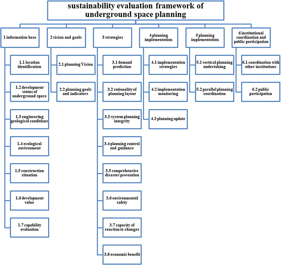
FIGURE 1. Sustainability evaluation framework of underground space plan.
It is the prerequisite for the formulation of sustainable underground space planning to comprehend accurate information of all aspects about the planning area. The planning document shall include the following basic information that has important limitations and reference functions for planning. First, it must include location identification; that is, the extent of the planning area and the vertical development depth shall be clearly defined. The scope of the planning area is the basic requirement of the planning. The planning depth should be defined according to the characteristics of the underground space planning. Second, the development status of the underground space is also needed. Compared with studies on the evaluation of various plan quality, the description of the core issues of the planning object is the necessary basic information; this is reflected in the description of the development status of the underground space in underground space planning. Third, engineering geological conditions not only determine the feasibility of the planning, but also have an important impact on the sustainability of the planning scheme. The development of underground space in areas with unfavorable engineering geology will increase construction and operation costs and energy consumption, resulting in negative externalities. The SUUSP requires that natural elements, such as landform, engineering geology, and hydrogeological conditions, must be evaluated. Fourth, the ecological environment, underground space resources, socio-economic conditions, human activities, and other basic elements together constitute the sustainable development system of urban underground space (Kong, 2006). There are complex interactions among the elements of underground space, so it is necessary to understand their relationship to realize the sustainable development of the system. Therefore, underground space planning should investigate the ecological environment, construction, and social and economic conditions of the planning area and explain them in the document. Fifth, the planning document must include a description of the construction situation. Sixth, the development value, including introduction to and analysis of social and economic situations and development interests in the planning area, must be outlined to demonstrate that the planning complies with local development requirements. Finally, a capacity evaluation must be provided. The planning must specify the realistic conditions that can support the planning, including the planning basis, a current plan evaluation, and financial capacity.
The development vision plays an important role in guiding the future construction of the city, reflecting breadth of values affected by the plan (Berke et al., 2012), and expressing future desired conditions grounded in community values (Horney et al., 2017). Therefore the following two layers must be stated in the planning document: 1) planning vision and 2) planning goals and indicators. First, as a part of urban planning, the development vision of underground space planning should adapt to the overall vision of the city to promote urban development and to reflect the relevant requirements of sustainability. Second, the underground space planning should establish specific construction goals and indicators on the economic, transportation, land use, and other elements involved, and should echo the requirements of sustainability.
Strategies are a guide to decision making to assure plan goals are achieved (Woodruff and Regan, 2019). The preparation of scientific and effective planning strategies and measures is the guarantee for the realization of sustainable objectives. The planning document should consider the following strategic measures conducive to the implementation of the plan.
The demand prediction for the development and utilization of underground space is the core question to be answered in the formulation of underground space planning (He et al., 2011). Accurately predicting the demand for underground space in the planning area can avoid over-development of underground space and balance the relationship between the environment and urban development. The SUUSP requires that in the overall planning stage, the urban underground space should “analyze and predict the scope, overall scale, zoning structure, leading functions, etc., of urban underground space utilization, and clarify the leading policy of urban underground space utilization.” In order to make the development of underground space more sustainable, it is very important to consider the quantitative indicators of underground space in the analysis process of demand prediction. Common quantitative indicators include the urban underground space volume, density, volume per person and premises floor area, etc (Bobylev, 2016).
Due to the non-renewable nature of underground space resources and the irreversibility of underground space development, the planning and layout of underground space should be justified in terms of plain, vertical, and development scale (Wang and Liu, 2014).
As a complete system, underground space includes subsystems, such as traffic facilities, municipal facilities, and civil air defense facilities. All subsystems need to be properly planned to realize the normal operation and sustainable development of the underground space system. This indicator item contains six coding items, covering eight categories of underground space facilities in the SUUSP.
One underground resource can provide competing or coexisting functions (Volchko et al., 2020), so underground space planning should play its role in balancing them. The planning document shall provide control and guidance on key issues of underground space development. The SUUSP refers to the guiding principles of functional integration, space humanization, and three-dimensional transportation for underground space.
Natural disasters, such as storms, tornados, and frost, rarely affect underground space. The probability of damage by fire in underground space is lower than above the ground (Sun and Xu, 2014). In addition, the underground space has good seismic and air defense performance. The planning document should consider the comprehensive disaster prevention measures of underground space.
During the preparation of underground space planning, attention should be paid not only to the development and utilization of underground space, but also to the improvement of the quality of human settlements and people’s use of underground space facilities (Wang, 2008).
Similar to other urban spaces, urban underground space is an uncertain dynamic system that changes with time. It is in the process of continuous evolution and development (Kong, 2006). Therefore, the adaptability of underground space to possible future changes should be considered in the planning, including the update of technology, the possibility of function transformation under different scenarios, such as peacetime and wartime, and future space expansion.
The construction of underground space must be economic and reasonable, and its social benefits can only meet the requirements of sustainability when they can make up for the construction expenditure.
Planning implementation is critical to the realization of sustainability. It can translate plan strategies into action, track progress toward goals (Woodruff and Regan, 2019), and clarify the attribution of responsibility.
To ensure the implementation of the plan, it is necessary to further decompose the objectives and strategies into specific action plans, including a project list, construction sequence, division of responsibilities, and so on. The current Urban Underground Space Planning Standard lacks this requirement.
The plan document shall formulate quantitative indicators to monitor the implementation of planning (Berke et al., 2012) to master the construction and operation and make timely adjustments.
Planning update is a vital means to adapt to future changes, including recognition of and approaches to overcome uncertainty (Woodruff and Regan, 2019). Corresponding to the characteristics of the dynamic evolution of underground space, underground space planning also needs to be revised with changes in various conditions. The planning document should specify the conditions for planning revision to ensure the sustainability after the external conditions change.
Urban planning is a complete system. In the planning system of China, underground space planning implements the requirements of urban master planning, serves as a guidance for detailed planning of underground space, and also coordinates with other special planning such as rail transit, public service facility and park facility (Zhao et al., 2016). The planning document should reflect how the underground space planning cooperates with other planning: 1) vertical planning undertaking, including accounting for the requirements of planning at higher levels and providing guidance to projects at lower levels; and 2) parallel planning coordination, which refers to the responses to other special plans at the same level.
Cooperating with other institutions and widely absorbing public opinions is an important means to improve the fairness and effectiveness of the planning. A platform to facilitate the communication among engineering geologists, civil engineers, architects, urban planners, urban designers and other stakeholders in spatial planning processes needs to be created (Volchko et al., 2020). It is a two-way communication process between the planning department and all sectors of the society. Its purpose is to ensure that the planning results are fully recognized by the public (Shao, 2014). The planning document should reflect: 1) coordination with other agencies, including other government departments and civil society; and 2) public participation; that is, the planning document should attract public participation through opinion solicitation and publicity to enhance public support for the plan.
As explained in Section 2, plan quality evaluation is generally evaluated according to an evaluation protocol. The main evaluation principles have been agreed and widely used in plan quality evaluation research and practice, especially in the United States. The content is basically fixed, while the indicators in the framework can be added or deleted according to the specific conditions.
We refer to the national adaptive plan evaluation system and the comprehensive disaster prevention plan evaluation system of the United States, and compare the underground space planning documents of Shenzhen, Suzhou, and other representative cities to adjust to China’s circumstances. We also add some indicators and coding items related to the development and construction of underground space, such as “above-ground and underground space compliance,” “underground temperature and humidity control,” and others.
Each coding item was divided into two categories according to its characteristic: “binary coding” or “degree coding” (He et al., 2019). An item coded as the former must be checked to determine whether there is corresponding content in the planning document. If there is no corresponding content, code 0; if there is corresponding content, code 1. For the degree coding category, we checked the depth of the description or discussion of the coding item in the document. If it is not mentioned, code 0; if the description or discussion is vague or lacking, code 1; if there is a detailed description or discussion, code 2.
Example:
1. Coding item 1.5.1 underground buried objects.
Zhuhai: 4.1.1 (3) ① Determine the natural ecological protection area, first-class water source protection area, ecological wetland protection area, ecological agriculture protection area, local unfavorable geological area, underground cultural relics burial area, national, provincial and municipal cultural relics protection units, and some urban special land as underground space prohibited construction areas.
5.2.1 (1) ⑥ Underground cultural relics burial areas include: sand dune site of Dong’ao Bay, Yapo Bay site of Qi’ao, Zhongshan port site, Chisha Bay site of Hengqin, ancient sand dune site of Caotang Bay, Xiahuan site of Nanxin Tang, Dahushui wellhead site, Gaolan Xieqianzui site, Baojing Bay site, underwater Tang dynasty ceramics site of Hebao island;
Score: Underground buried objects are considered and the specific area is defined; This encoding item is encoded as 2.
2. Coding item 3.5.3 earthquake resistance.
Shenzhen: Article 24 of Chapter VI: “Shenzhen should focus on the geological factors that may cause potential safety hazards, such as fracture zones, foundation Baering capacity, karst, groundwater, seawater intrusion, and earthquake liquefaction, and the city should take countermeasures in advance during the development and utilization of underground space.”
Score: The geological risk factors that should be paid attention to and take corresponding measures are mentioned, but there is no clear response strategy; This encoding item is encoded as 1.
Suzhou: 15.3 “Earthquake prevention”: “Generally speaking, under the earthquake action of design intensity, the underground structure should not be damaged or slightly damaged. Under the earthquake action of beyond design intensity, the structure may be damaged, but the main function will not be lost, or there will be no serious damage endangering the lives of people inside. The seismic structure design of underground space should be carried out according to the urban fortification intensity. The fortification intensity of important underground works, such as subway, lifeline works, important underground buildings, and underground roads, should be equal to that of underground buildings. Other underground works can be designed by reducing the basic fortification degree by one degree. The construction site of underground space shall avoid unfavorable engineering geological sites, such as fault fracture zones, steep bank slopes, and unstable hillsides. When the underground space structure supports the original soft clay, liquefied soil, or other uneven soil layers, it is advisable to take measures to strengthen the integrity and rigidity of the foundation. The structural members of underground space shall have sufficient strength, good deformation capacity and energy consumption capacity, strong corrosion resistance and durability. The structural system of underground space should have a reasonable and simple seismic action transmission path. Each unit is relatively independent and cannot affect another structural unit due to the damage of one structural unit.”
Score: There are clear anti-earthquake measures and design guidelines; This encoding item is encoded as 2.
In order to improve the reliability of planning document evaluation quality, the double coding technique is mostly used in research (Song et al., 2017; He et al., 2019). In this technique, at least two researchers are required to score the coding items of the planning document. In the first round, the two researchers should conduct a pre-evaluation test to ensure the consistency of understanding and scoring of the coding items of the evaluation framework. The second round, in the formal scoring phase, two researchers encode all items of each planning document, then the team computed an intercoder reliability score that indicates the percentage of items that were coded for the same value by both coders (Song et al., 2017). According to experience, when the coder reliability exceeds 70%, the result is considered credible (Berke and Godschalk, 2009). The double coding technique can better eliminate errors caused by the subjective knowledge and personal experience of the raters, and make the evaluation results more reliable.
The evaluation process of planning document in this paper is adjusted and improved on the basis of double coding technology. In order to ensure the credibility of the evaluation results, the planning document evaluation procedure in this paper is adjusted and improved on the basis of double coding technique. For 40 urban underground space master plans, four research assistants were invited to participate in the evaluation. In the first round, the two researchers should conduct a pre-assessment test to ensure the consistency of understanding and scoring of the coding items of the evaluation framework. First, all of assistants coded for all items in a test planning document. The coding items with large differences in the evaluation results were analyzed, discussed and corrected to ensure the consistency of the assistants’ understanding of the coding items. The new test document was selected for evaluation again, and the process is repeated until the coding consistency of the four assistants can pass the coder reliability test (using SPSS software, Kendall synergy coefficient >0.7). During the pre-evaluation test, we selected the Recent Construction Plan for the Development and Utilization of Urban Underground-Space in Zhuhai (2013–2020) for a credibility test. The result showed that the Kendall coefficient was 0.615, which did not meet the requirements. After discussing the differently scored coding items, the Urban Underground-Space Development and Utilization Master Plan of Nanjing (2017) was selected for evaluation. The result showed that the Kendall coefficient was 0.792, thus meeting the requirement. Therefore, it could be considered that the coders had reached a consensus on the evaluation standard.
After passing the reliability test, according to the optimal combination of coder reliability between two assistants, the assistants were divided into two groups, two assistants in each group. Then, each assistant was responsible for evaluating 10 underground space planning documents and scoring the first-round of evaluation. After the evaluation, the partners in the group exchanged the underground space planning document and revised the scoring results of the first-round. For the disputed coding items, the final results are given after negotiation. This method absorbs the advantages of the double coding technique, which can effectively eliminate the influence of the coders’ subjective knowledge and personal experience. At the same time, it avoids the coders’ repeated evaluation of the same document and improves the credibility of the results. Selecting a test planning document for a credibility test is helpful to improve the efficiency of the evaluation procedure.
Under this evaluation system, there are 24 coding items in the “information base” dimension, with a total score of 40; nine coding items in the “vision and goals” dimension, with a total score of 18; 34 coding items in the “strategies” dimension, with a total score of 67; 10 coding items in the “planning implementation” dimension, with a total score of 19; four coding items in the “planning coordination” dimension, with a total score of seven; and six coding items in the “institutional coordination and public participation” dimension, with a total score of 11. Considering that the number of coding items in each dimension varies greatly, and the scale of the two coding methods of “binary coding” and “degree coding” are different. In order to facilitate the comparison and analysis of the scores among various dimensions, and to clarify the strengths and weaknesses of China’s underground space planning, we standardized the scores of various dimensions and indicators. The standardization steps are as follows.
The coding items of “binary coding” was standardized to a 0–2 scale. On this basis, add the scores of coding items under each indicator item to obtain the total score of the indicator item. Calculate the standardized mean score of each indicator item using the total score:
Then add the standardized mean score of each indicator item under the same dimension to obtain the total score of the dimension. Similarly, the mean standardized score of each dimension can be calculated as follows:
The total score and the score of each dimension after standardization are showed in Supplementary Table S3.
In terms of geographical distribution, 30 case cities are located in eastern China, while 10 case cities are located in the central and western regions (Lanzhou, Xi’an, Wuhan, Wuhu, Bengbu, Changsha, Xiangtan, Nanning, Guangyuan, and Guang’an). Statistics show that there is a big gap between the quality of underground space planning documents in the central and western regions and the eastern region, with a difference of 0.43 in the mean total score. In all six dimensions, the mean score of the vision and goals dimension of the central and western regions was slightly higher than that of the eastern region, and the mean score of the other five dimensions was lower than that of the eastern region (Figure 2).
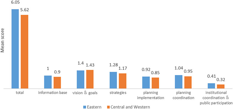
FIGURE 2. Comparison of eastern region with central and western regions.
By further analyzing the scores of cities located in different urban agglomerations, it was found that, as the two most important urban agglomerations in China, the Yangtze River Delta urban agglomeration and the Guangdong Hong Kong Macao Great Bay area had significantly higher scores, while cities in the Shandong Peninsula urban agglomeration, Middle Yangtze River urban agglomeration, and West Bank of the Taiwan Strait urban agglomeration had lower scores (Figure 3).
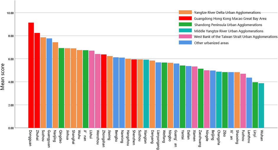
FIGURE 3. Scores divided by urban agglomerations.
In terms of planning time, 40 cases were divided into three stages: 2010 and before (n = 13), 2011–2015 (n = 15), and 2016–2020 (n = 12). The distribution was relatively uniform. We observed how the quality of the underground space planning document changed with time.
From the mean of the total scores, the scores of the latter two stages were slightly lower than those of the first stage. With reference to each dimension, we found that the scores for strategies, institutional coordination, and public participation have been increasing, and the scores for planning coordination and information base have also improved a little; however, the scores for vision and goals and planning implementation have been decreasing. Therefore, the quality of the planning document did not improve with time, but changed differently on each dimension (Figure 4).
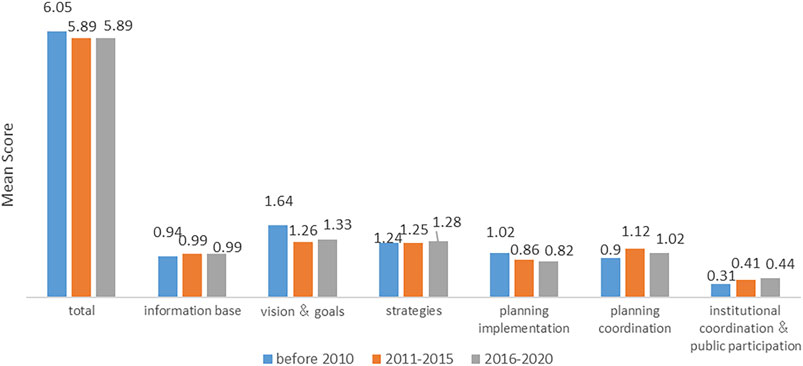
FIGURE 4. Comparison of formulation time.
The mean score for the information base was 0.97. The main reason for the low score might be that some cities did not include the relevant indicators in the planning document, or they only presented them in the annex (e.g., Bengbu, Ningbo, Shaoxing, Nanning, Shenzhen). The frequency distribution histogram also showed that there were many low-scoring cases (below 1 point) in this dimension, and the score differences between them were great (Figure 5).
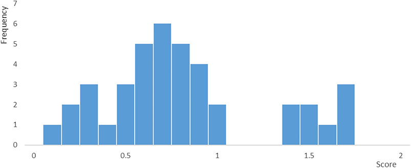
FIGURE 5. Score distribution of the dimension “information base”.
Taking the Shenzhen Underground-Space Resources Utilization plan (2020–2035) formulated in 2021 as an example, the document reached the mean level in the other five dimensions, but there was little description of the basic setting of the planning area. The fact-base dimension was only 0.25, far lower than that of Dongguan (1.70) and Shanghai (1.00) in the same period; this ultimately affected the overall score of the planning document.
By analyzing the scores of each indicator under this dimension, we observed that there were large gaps between items, and five of the seven indicators were lower than the mean score for this dimension (Figure 6). The score of indicator 1.3, “engineering geological conditions,” was significantly lower than the other six indicators. The engineering geological conditions have an important impact on the sustainability of the planning scheme and should be described in detail.
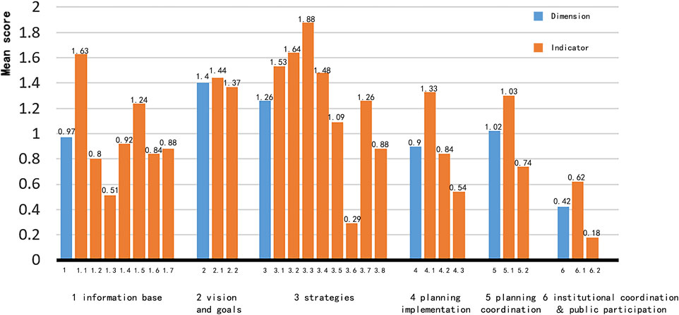
FIGURE 6. Scores of indicator items under the six dimensions.
The mean score of vision and goals was 1.40, which was the highest among the six dimensions, and the score distribution was relatively uniform, with few low scores. However, over time, the mean score on this dimension decreased after 2010. The decline might be mainly due to the more comprehensive planning objectives in the early documents that involved various fields, such as the economy, resources, transportation, and urban renewal. For example, the Plan for the Development and Utilization of Underground-Space of Xiamen City, prepared in 2007, posited goals on seven aspects, including land use and space capacity. The plans after 2010 were more targeted. They mainly put forward specific goals for the most urgent problems of underground space, rather than involving all aspects. For example, the Special Plan for the Development, Utilization and Protection of Underground-Space in Shanghai, prepared in 2020, only emphasized the four important concepts of strictly protecting underground space resources, building an efficient three-dimensional city, tapping the potential of space resources, and ensuring urban safety.
In general, the scores of the three indicators of this dimension are relatively close (Figure 6). In terms of specific development goals, such as the economy, function, and transportation involved in indicator 2.2 “planning objectives and indicators,” the scores of items 2.2.1 “economic objectives” and 2.2.5 “environmental protection objectives” were low. More attention should be paid to the economic and environmental indicators in the formulation of development goals.
The mean score of strategies was 1.26. This dimension mainly involves the core issues of underground space planning, such as demand forecasting, spatial layout, system planning, facilities planning, and disaster prevention. These indicators were highlighted in each document, and the scores slightly improved over time (Figure 4), indicating that the design method and technology of underground space planning have made some progress.
Since there are 34 coding items in this dimension, an overall analysis would be vague, so the score was analyzed using the specific indicators (Figure 6). The overall score of each item was good, and five of the eight items were at or above mean. The mean score of item 3.3 “system planning integrity” was the highest, reaching 1.88. Each case has a relatively full explanation of the layout of underground space facilities. The mean score of item 3.6 “environmental safety” was the lowest, only 0.29, which was far lower than the others and reduced the overall score of this dimension to a considerable extent. This indicator involves factors that are directly related to the user experience and control the underground space, such as lighting and ventilation, air quality, and temperature and humidity. The low score of this item suggested that there are still considerable deficiencies in the consideration of underground space design. The huge score difference between items 3.3 and 3.6 reflected that China’s underground space planning focused on engineering technology and facility layout, while neglecting user experience and space quality. In addition, the mean score of item 3.8 “economic benefit” was only 0.88. This item involves cost calculation, investment and financing, and ownership management. It plays an important reference role in the implementation of the project and should be given more attention.
The mean score of planning implementation was 0.90. This score was low and it decreased significantly over time (Figure 7). This dimension involves the implementation, adjustment, and feedback of the plan, and it plays a key role in realizing the sustainability goal of underground space planning.
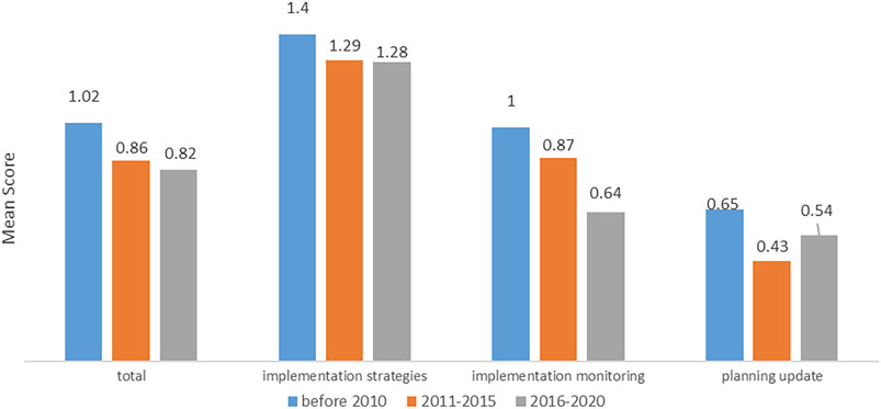
FIGURE 7. Scores of indicator items under the dimension “planning implementation,” by time period.
By observing the scores of each indicator on this dimension at different time stages, we found that the mean scores of all three items for the cases after 2010 were lower than those before 2010, especially the score for item 4.2 “implementation monitoring,” which dropped from 1.00 to 0.64, a large decline. If the guidance on planning implementation in the document is unclear, it may easily lead to difficulties in inspecting the planning implementation progress, distributing responsibilities, and a lack of a basis for planning adjustment.
By analyzing the scores of the indicators, we saw that there were large gaps (Figure 6). This reflected the problem that planning implementation focused more on implementation strategies while neglecting implementation monitoring and planning updates. As an irreversible process, underground space development should respond to possible changes in the future before implementation to update the planning over time. This is of great significance to the sustainability of underground space planning and should be prioritized.
China’s first urban underground space planning standard, the SUUSP was issued in 2019 and focused on resource assessment, demand analysis, spatial layout, special planning, and other topics. However, the lack of requirements for the implementation, coordination, and participation in the plan may lead to insufficient attention being paid to these dimensions going forward.
The mean score for planning coordination was 1.02, which was moderate, but the scores of the two indicators on these dimensions were different (Figure 6).
The mean score of item 5.1 “vertical planning undertaking” was 1.30, while the mean for item 5.2 “parallel planning coordination” was only 0.74. It can be seen that China’s underground space planning is relatively mature in connecting superior and subordinate planning, but there are still major deficiencies in coordinating other special plans at the same level. As a result, conflicts may arise in land use, affecting the implementation of the planning and the realization of the urban development goals.
The mean score of institutional coordination and public participation was 0.39. This dimension had the lowest score and a wide gap with other dimensions. Institutional coordination and public participation are serious deficiencies in the underground space planning system of China. Although the mean score increased from 0.31 before 2010 to 0.44 in 2016–2020, with the largest increment among the six dimensions, the absolute value of the dimension is still far from its counterparts, which needs to be improved.
In addition, the scores of items under this dimension were extremely uneven (Figure 6). According to the statistical results, the score of indicator 6.1 “coordination with other institutions” was 0.62, while the mean for indicator 6.2 “public participation” was only 0.18. For item 6.1, the mean score for item 6.1.1 “coordination within local government” was 1.58, while the means for 6.1.2 “coordination with local independent groups and non-governmental organizations” and 6.1.3 “coordination with institutions outside the administrative region” were only 0.23 and 0.05, respectively. This dimension had a serious problem of overemphasizing institutional coordination and neglecting public participation. In terms of institutional coordination, there were also problems of emphasizing local inter-governmental coordination, and neglecting regional institutional coordination and coordination with non-governmental organizations.
To study the characteristics of extreme value samples, we selected the Comprehensive utilization planning of underground space in Dongguan, with the highest score, and the Plan for Comprehensive Utilization of Underground Space in Wuhan, with the lowest score, for comparative interpretation. The formulated time of the two planning documents was near, and the social and economic indicators, such as city level, population, and per capita GDP of the corresponding cities, were close, which was suitable for comparative analysis.
Dongguan’s document scored well, receiving more than 1 point for all six dimensions; four of the dimensions scored more than 1.5, especially in the two dimensions of information base (0.78 higher than the mean) and institutional coordination and public participation (1.11 higher than the mean). In addition, Dongguan’s document was outstanding on some items that appeared weak overall. For example, in the information base dimension, indicator 1.2 “underground space development status” received 2.00 (1.20 higher than the mean for the 40 cases), indicator 1.3 “engineering geological conditions” received 1.25 (0.74 higher than the sample mean), indicator 3.6 “environmental safety” received 1.00 (0.71 higher than the mean), and indicator 3.8 “economic benefit” received 1.67 (0.79 higher than mean). The lack of weak indicator items was the key to the high score of Dongguan’s document.
The scores for Wuhan’s document had large gaps with the means on all dimensions, especially in vision and goals, planning implementation, and planning coordination. Specifically, Wuhan’s document reached or exceeded the mean level in terms of items related to the core issues of spatial planning, such as indicator 1.3 “engineering geological conditions,” indicator 1.4 “ecological environment,” indicator 3.2 “rationality of planning layout,” and indicator 3.3 “integrity of system planning.” This means that, as the plan for a developed megacity, Wuhan’s document met the requirements for engineering technology. The main reason for its low score was that the document seriously lacked consideration of “soft indicators,” such as planning conditions, system, and coordination.
Through a comprehensive review of the overall documents, we found that, except for the institutional coordination and public participation dimension, which was still in its infancy, the planning implementation dimension had the lowest score in both the mean and extreme cases, indicating that China’s underground space planning documents generally attaches importance to the vision and goals, but the attention to the implementation of planning is generally insufficient.
By comprehensively analyzing the evaluation scores of 40 urban underground space master plan documents selected in this study, the following conclusions can be drawn:
1) The overall score was not high, and the gaps between cases in the sample were large. The standardized mean score of the 40 cases was only 5.94, less than half of the theoretical full score, indicating that there is still room for improvement in the quality of underground space planning documents in China. At the same time, the score range was large, reaching 5.26, indicating that the quality of documents was uneven.
2) There were great regional differences. The mean scores of cities in the eastern region were higher than those in the central and western regions, especially for cities in the Yangtze River Delta urban agglomeration and the Guangdong Hong Kong Macao Great Bay area. This indicates that the level of regional economic development had a meaningful impact on the quality of documents.
3) There was a tendency to focus on the goals and strategies and ignore implementation. By analyzing the six dimensions, we found that the “vision and goals” and “strategies” categories had the highest scores, and the scores of each coding item were good, while the “planning implementation” and “institutional coordination and public participation” items had the lowest scores. This suggests serious deficiencies in the preparation of China’s current underground space planning document. Moreover, it demonstrates that China’s underground space planning is relatively mature in terms of traditional planning, such as goal formulation, spatial arrangement, design strategies, and other factors, but it still lacks consideration of planning implementation and social participation.
4) The document also emphasized engineering technology and ignored humanistic care. In terms of the various “strategies,” the score for item 3.2 “system planning integrity,” involving underground space system planning, was as high as 1.88, while the score on item 3.6 “environmental safety,” involving user experience and environmental comfort, was only 0.29. The dimension “institutional coordination and public participation,” which involves public participation and ensures planning fairness, scored the lowest. This indicates that the design method and technology of underground space planning in China were mature, but the human touches of underground space design and the fairness of planning were not considered enough. The study of extreme value documents also reflected this problem.
As a form of comprehensive planning, underground space planning and the quality of relevant documents may be affected by the objective needs of underground space development in the planned area and by subjective factors, such as the experience and qualifications of the planning department. On the basis of evaluating the underground space plans of 40 cases, this study further analyzed the relationships between the plan quality and socio-economic factors to find the main variables that affect the quality of planning documents.
In different regions of the city, the degree of scarcity of space resources, traffic conditions, and the level of economic development are different. These variables determine the development needs of urban underground space and are the fundamental motivation to promote underground space planning and construction (Zhang, 2020). Previous studies confirmed that the spatial distribution and characteristics of socio-economic factors have an important impact on the development potential of underground space, mainly including population, economy, transportation, location, and other factors. Xu et al. (2008), Wang (2008), and Liu et al. (2014) argued that location and economic factors are important indicators determining the development stage of underground space; Chen et al. (2007) and He et al. (2012) demonstrated that there is a strong correlation between urban population, urban economy, housing prices, and underground space development demand. Finally, Song (2008) and Sun et al. (2018) supplemented this work by exploring the impact of traffic factors on underground space development demand in addition to population and location factors.
Based on the above research and the analysis of plan quality presented here, we posited the following assumptions about the influencing factors.
Urban land resources with small administrative areas are relatively scarce, and local governments may pay more attention to the sustainability of underground space. The area of an administrative region is negatively correlated with the plan quality.
High population density means a city needs high-intensity development to accommodate its citizens, and it is therefore more necessary to develop sustainable underground space. Population density is positively correlated with the plan quality.
Compared with cities in western and central China, cities in eastern China pay more attention to the sustainable development of underground space. The plan quality of urban underground space master plans in eastern China is higher.
The land price index related to urban economic development can reflect the economic value of land and the value of developing underground space. Land price is positively correlated with the plan quality of urban underground space planning.
The length of the metro line represents the scale of underground space; that is, it indicates that the underground space planning may be more mature. The length of the metro line is positively correlated with the plan quality.
Taking the evaluation scores as dependent variables, this study selected five socio-economic factors as independent variables, including administrative area, population density, economic region division, land price, and length of the local metro line, to analyze the relationship between the objective demand of urban underground space development and the quality of planning documents. At the same time, it studied the relationship between the planning department and the plan quality.
After collecting socio-economic indicators from 40 cases (Supplementary Table S4), this study used SPSS software to conduct a multivariate regression analysis to test the impacts of five socio-economic factors on the plan quality scores. All five variables were included in the analysis. The results are shown in Table 1. The F-value is 9.839, and the p-value is 0.005; this means that the independent variables have a significant impact on the dependent variable. The R2 value is 0.786, suggesting that the independent variables explain 78.6% of the variation in the dependent variable. The model therefore has strong explanatory ability.
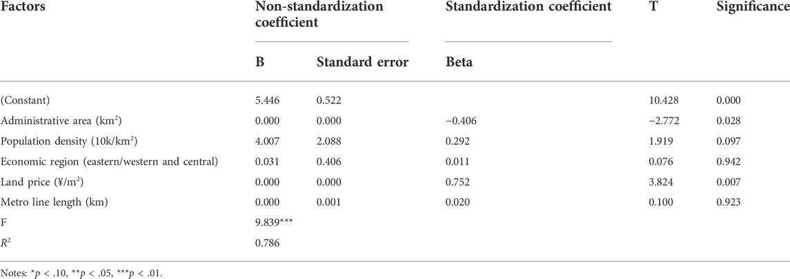
TABLE 1. Construction results of regression model.
According to the standardized regression coefficient and the significance of each variable, the two independent variables of economic region (east/middle west; b = 0.011, t = 0.076, p > 0.10) and metro line length (b = −0.020, t = 3.824, p > 0.10) have no significant impacts on the plan quality. Administrative area (b = −0.406, t = −2.772, p < 0.05) has a significant negative impact on the plan quality, while population density (b = 0.292, t = 1.919, p < 0.10) has a significant positive impact on the plan quality. Land price (b = 0.752, t = 3.824, p < 0.01) has a very significant positive impact on the plan quality.
As shown in Figure 8, the statistical analysis of the mean plan quality of urban underground space planning and the planning departments showed that there was a significant correlation: The documents formulated by domestic well-known design institutes had the highest mean score, followed by local planning institutes, foreign firms, joint compilation units, universities, local governments, and others.
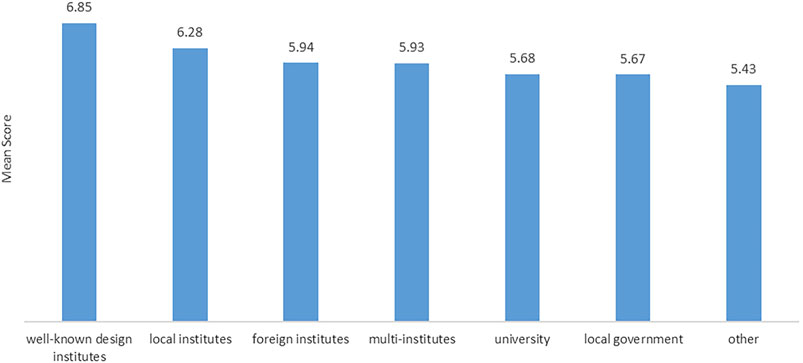
FIGURE 8. Mean scores for plan quality and the local planning departments.
1) The impact of land price on plan quality score showed the most significant positive correlation. Due to the high costs of developing underground space, it is relatively uneconomical to develop underground space in areas with low land prices. The higher the land price, the higher the economic value of the unit land, and the greater the benefits of developing underground space. The five cities with the lowest and highest land prices were selected to analyze their scores in each dimension. It was found that the top five cities (Shenzhen, Shanghai, Zhuhai, Dongguan, and Qingdao) received higher scores on five dimensions than the mean, especially for the dimensions of information base, planning coordination, institutional coordination, and public participation. The higher score of institutional coordination and public participation indicates that the market factor of high land prices makes cities more active, and underground space planning can take more account of the participation of social forces. The mean scores on the six dimensions for the bottom five cities (Guang’an, Linyi, Zaozhuang, Lanzhou, and Zibo) are lower than the mean, especially on vision and goals and planning coordination (Table 2).
2) The influence of the administrative area on the plan quality scores showed a significant negative correlation. The administrative area refers to the total amount of land resources under the jurisdiction of the local government. A smaller administrative area indicates that there are fewer land resources available for urban development and construction. The scarcity of land resources may lead local governments to pay more attention to the sustainable development and utilization of underground space. It was found that the five cities with the smallest administrative areas (Xiamen, Zhuhai, Zhongshan, Shenzhen, and Dongguan) scored higher than mean on five dimensions, except for the vision and goal dimension, which was slightly lower than mean. These cities also took a large lead in planning coordination, institutional coordination, and public participation. This suggests that these cities consider the external influencing factors of underground space more profoundly. The mean scores of the five cities with the largest administrative regions (Guangyuan, Beijing, Linyi, Lishui, and Nanning) received higher scores on vision and goals and lower scores for planning coordination. This indicates that cities with larger administrative areas have a large amount of available land resources and can put forward broader and more comprehensive underground space development goals. However, the concept of smart development is insufficient, and the coordination among different plans is weak.
3) The influence of population density on plan quality showed a significant positive correlation. In cities with high population density, the population is more concentrated and the urban development intensity is higher, which creates greater demand for the expansion of the city’s underground space. Making such changes can ease urban functions, accommodate more activities, and ease the tension created by urban development and sprawl. The five cities with the highest population density (Zhongshan, Xiamen, Dongguan, Suzhou, and Shenzhen) scored higher than the mean for all six dimensions, indicating that these cities had fully considered all dimensions of underground space planning. The overall scores of the bottom five cities for population density (Guang’an, Guangyuan, Lanzhou, Ningde, and Jinhua) are close to the mean level; the scores on vision and goals are very high, but the scores on information base and planning implementation are low.
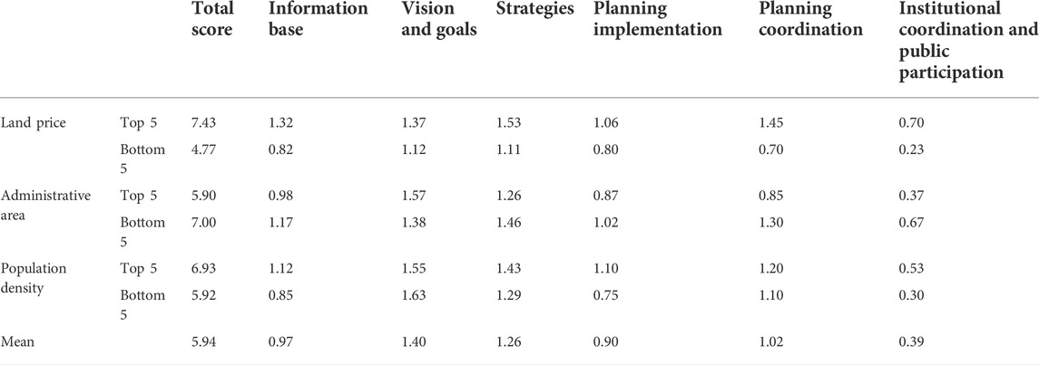
TABLE 2. Scores of top and bottom cities for each influencing factor.
Through the comprehensive analysis of the above three most significant influencing factors we found that land price directly reflects the development value of urban land, the size of the administrative area reflects the total amount of urban land resources, and population density reflects the development intensity required by the city. The above factors comprehensively show that the value of land resources is the core factor affecting the quality of underground space planning documents and the main driving force for urban underground space development.
4) The qualifications of planning and design departments had an important impact on the quality of urban underground space master plans. Well-known planning and design companies in China have a long history, abundant human resources, a nationwide market share, and technical accumulation in the field of underground space planning.
Comparing cities with high scarcity of urban space resources (Shenzhen, Shanghai, Zhuhai, Dongguan,Qingdao, Zhongshan, Suzhou) with their planning departments (Supplementary Table S1), we found that there might be a connection: cities with high scarcity of urban space resources generally chose well-known design companies. Therefore, to improve the quality of urban underground space planning, the local government should be more inclined to select well-known local design institutes to aid in this development. At the same time, these pioneer institutes are also obligated to take the lead in formulating technical guidelines and standards for the preparation of underground space planning, and to share relevant preparation experiences and technology with other planning departments.
The large-scale development and utilization of urban underground space in China began with the civil air defense construction. The formulation of underground space planning was also led by the civil air defense departments. With the improvement of the understanding and utilization of underground space, this has gradually become an important urban space resource. Now, the comprehensive planning and management departments are responsible for and lead the formulation of underground space planning. After 20 years of development, this form of urban planning has distinctive characteristics: it has relatively mature engineering technology, but the differences in the quality of the planning documents are still large, the development between regions is uneven, and there are problems of emphasizing design strategies and engineering technology while neglecting implementation and humanistic care, especially in social participation. Therefore, it is suggested that while maintaining the level of the engineering technology, efforts should be made to improve the weak items, pay more attention to planning implementation and social participation, and improve relevant legislation and regulations. The administrative area, population density, and land price are the main factors affecting the quality of urban underground space planning, and these variables are closely related to the scarcity of urban space resources, which is the main driving force for the development of urban underground space and the core influencing factor for its sustainability. The selection of planning departments also has an important impact on the quality of underground space planning. We suggest introducing policies to promote high-level, large-scale planning departments to provide personnel and technical support to underdeveloped areas.
Due to the limitations of sample size and data collection, there are still some limitations to this study. Since most of the cases are in eastern China, there might be a deviation in the reflection of the differences between the eastern region and the western and central regions. In addition, the lack of partial information on the development area of underground space, the number of motor vehicles, and the planning departments might also lead to an incomplete analysis of the influencing factors. In the future, more in-depth research can be carried out on the basis of optimizing samples and obtaining more comprehensive data in combination with international practices.
The original contributions presented in the study are included in the article/Supplementary Material, further inquiries can be directed to the corresponding author.
LH and ZX contributed to the study concept and design. ZX and MZ contributed to the acquisition of data. MZ contributed to the initial drafting of the manuscript. LH, MZ and ZX contributed to study supervision. All authors contributed to the critical revision of the report.
This work was supported by the National Key Research and Development Program of China (2020YFB2103901-2); National Natural Science Foundation of China 51778437) and Technical standard of Shanghai 2021 “Scientific and technological innovation action plan” (21DZ2206500).
The author would like to express deepest gratitude to the six research assistants who helped in this study: Qicheng Ma, Bosen Duan, Jingyi Ren, Xiaodong Chen, Yao Yao and Jing Zhao, who participated in the evaluation of the planning document and helped collect relevant data.
The authors declare that the research was conducted in the absence of any commercial or financial relationships that could be construed as a potential conflict of interest.
All claims expressed in this article are solely those of the authors and do not necessarily represent those of their affiliated organizations, or those of the publisher, the editors and the reviewers. Any product that may be evaluated in this article, or claim that may be made by its manufacturer, is not guaranteed or endorsed by the publisher.
The Supplementary Material for this article can be found online at: https://www.frontiersin.org/articles/10.3389/fenvs.2022.966157/full#supplementary-material
Baer, W. C. (1997). General plan evaluation criteria: An approach to making better plans. J. Am. Plan. Assoc. 63 (3), 329–344. doi:10.1080/01944369708975926
Berke, P. R., and French, S. P. (1994). The influence of state planning mandates on local plan quality. J. Plan. Educ. Res. 13 (4), 237–250. doi:10.1177/0739456x9401300401
Berke, P. R., Godschalk, D. R., Kaiser, E. J., and Rodriguez, D. A. (2006). Urban land use planning. Fifth Edition. New York: Oxford University Press.
Berke, P. R., and Godschalk, D. R. (2009). Searching for the good plan: A meta-analysis of plan quality studies. J. Plan. Literature 23 (3), 227–240. doi:10.1177/0885412208327014
Berke, P. R., Smith, G., and Lyles, W. (2012). Planning for resiliency: Evaluation of state hazard mitigation plans under the disaster mitigation act. Nat. Hazards Rev. 13 (2), 139–149. doi:10.1061/(asce)nh.1527-6996.0000063
Bobylev, N. (2016). Underground space as an urban indicator: Measuring use of subsurface. Tunn. Undergr. Space Technol. 55, 40–51. doi:10.1016/j.tust.2015.10.024
Broere, W. (2016). Urban underground space: Solving the problems of today’s cities. Tunn. Undergr. Space Technol. 55, 245–248. doi:10.1016/j.tust.2015.11.012
Burby, R. J., May, P. J., Berke, P. R., Kaiser, E. J., Dalton, L. C., and French, S. P. (1997). Making governments plan: State experiments in managing land use. Baltimore, Maryland, USA: JHU Press.
Chen, Z. L., Wang, Y. B., Liu, H., and Xiao, Q. F. (2007). Prediction of underground space needs. Planner 23, 9–13.
Feinberg, D. S., and Ryan, C. M. (2022). Mitigating natural hazards: County-level hazard mitigation plan quality in Washington state. J. Environ. Plan. Manag. 65 (12), 2318–2332. doi:10.1080/09640568.2021.1971955
He, L., Dai, S. Z., and Song, Y. (2011). A research on multi-hazard mitigation planning in China with a reference to US experience. Urban Plan. Forum 2011, 87–94.
He, L., Song, Y., Dai, S. Z., and Durbak, K. (2012). Quantitative research on the capacity of urban underground space–The case of Shanghai, China. Tunn. Undergr. Space Technol. 32, 168–179. doi:10.1016/j.tust.2012.06.008
He, L., Xie, Z. A., Peng, Y., Song, Y., and Dai, S. Z. (2019). How can post-disaster recovery plans be improved based on historical learning? A comparison of wenchuan earthquake and lushan earthquake recovery plans. Sustainability 11, 4811. doi:10.3390/su11174811
Horney, J., Nguyen, M., Salvesen, D., Dwyer, C., Cooper, J., and Berke, P. (2017). Assessing the quality of rural hazard mitigation plans in the southeastern United States. J. Plan. Educ. Res. 37 (1), 56–65. doi:10.1177/0739456x16628605
Kong, L. X. (2006). Evaluation model and policies for sustainable development of urban underground space. Master’s thesis (Shanghai: Tongji University).
Lin, L., and Shen, S. (2009). Progress and prospects in research on urban planning evaluation in China. Shanghai Urban Plan. Rev. 2009, 14–17.
Liu, C., Zhao, Z., and Li, H. (2022). Re-Understanding urban underground spaces planning in the spatial system. Urban Dev. Stud. 29, 48–53.
Liu, Y. F., Song, Z. Q., and Sun, H. L. (2014). Analysis of the influence of economic factors on the development and utilization of underground space in the city center. Appl. Mech. Mater. 2014, 584–586.
Lyles, W., Berke, P., and Smith, G. (2014). A comparison of local hazard mitigation plan quality in six states, USA. Landsc. urban Plan. 122, 89–99. doi:10.1016/j.landurbplan.2013.11.010
Peng, F. L., Qiao, Y. K., Sabri, S., Atazadeh, B., and Rajabifard, A. (2021). A collaborative approach for urban underground space development toward sustainable development goals: Critical dimensions and future directions. Front. Struct. Civ. Eng. 15, 20–45. doi:10.1007/s11709-021-0716-x
Shao, J. Z. (2014). Assessment system of sustainable development for underground space planning. J. PLA Univ. Sci. Technol. Nat. Sci. Ed. 15, 240–245.
Song, M. C. (2008). The evaluation of potential of urban underground space based on social and economic factors. Master’s thesis (Tianjing: Tianjin University of Commerce).
Song, Y., Jiang, Z. Y., Yang, X. C., and Chen, Y. P. (2010). Urban plan evaluation: Learning from American examples. Planners 26, 5–9.
Song, Y., Li, C. S., Olshansky, R., Zhang, Y., and Xiao, Y. (2017). Are we planning for sustainable disaster recovery? Evaluating recovery plans after the wenchuan earthquake. J. Environ. Plan. Manag. 60, 2192–2216. doi:10.1080/09640568.2017.1282346
Song, Y., Tang, Y., Ding, G. S., and Chen, Y. P. (2015). Content and methods of plan document evaluation: Case study of the US cities. Urban Plan. Int. 30, 71–76.
Sun, L. P., Li, X. Z., Zhou, D. K., Wang, R., and Liu, C. (2018). Study on the correlation between underground space development and socio-economic factors. Chin. J. Undergr. Space Eng. 14, 4–13.
Sun, X. J., and Xu, Y. F. (2014). Exploration and practice of urban underground space development and utilization. Value Eng. 36, 132–133.
Talen, E. (2001). School, community, and spatial equity: An empirical investigation of access to elementary schools in West Virginia. Ann. Assoc. Am. Geogr. 91 (3), 465–486. doi:10.1111/0004-5608.00254
United Nation (2013). World population prospects: The 2012 revision. New York City, NY, USA: United Nations, Department of Economic and Social Affairs, Population Division.
Volchko, Y., Norrman, J., Ericsson, L. O., Nilsson, K. L., Markstedt, A., Öberg, M., et al. (2020). Subsurface planning: Towards a common understanding of the subsurface as a multifunctional resource. Land Use Policy 90, art. no. 104316. doi:10.1016/j.landusepol.2019.104316
Wang, B. (2008). Exploration and practice of urban underground space development and utilization. Master’s thesis (Beijing: China University of Geosciences).
Wang, X., and Liu, S. Y. (2014). Evaluation for urban underground space detailed planning scheme based on combined evaluation method. J. Southeast Univ. Sci. Ed. 44, 1072–1077.
Woodruff, S. C., and Regan, P. (2019). Quality of national adaptation plans and opportunities for improvement. Mitig. Adapt. Strateg. Glob. Chang. 24 (1), 53–71. doi:10.1007/s11027-018-9794-z
Xu, G. Q., Zheng, S., and Hu, L. L. (2008). Demand forecast of the underground space based on the idea of harmonious development. Urban Plan. Forum 2008, 231–234.
Zhang, L., Chen, W. D., and Pan, Q. H. (2017). Implementation summarized and formulate suggestion for urban underground space development administration measure. Planners 33, 55–60.
Zhang, R. D. (2020). Research on forecast of urban underground facilities demand based on socio-economic factors. Master’s thesis (Beijing: Beijing University of Civil Engineering and Architecture).
Keywords: sustainability, underground space planning, plan evaluation, plan quality, text analysis
Citation: Zhang M, Xie Z and He L (2022) Does the scarcity of urban space resources make the quality of underground space planning more sustainable? A case study of 40 urban underground space master plans in China. Front. Environ. Sci. 10:966157. doi: 10.3389/fenvs.2022.966157
Received: 10 June 2022; Accepted: 17 October 2022;
Published: 04 November 2022.
Edited by:
Wenping Liu, Huazhong Agricultural University, ChinaReviewed by:
Nikolai Bobylev, Saint Petersburg State University, RussiaCopyright © 2022 Zhang, Xie and He. This is an open-access article distributed under the terms of the Creative Commons Attribution License (CC BY). The use, distribution or reproduction in other forums is permitted, provided the original author(s) and the copyright owner(s) are credited and that the original publication in this journal is cited, in accordance with accepted academic practice. No use, distribution or reproduction is permitted which does not comply with these terms.
*Correspondence: Lei He, bGVpaEB0b25namkuZWR1LmNu
Disclaimer: All claims expressed in this article are solely those of the authors and do not necessarily represent those of their affiliated organizations, or those of the publisher, the editors and the reviewers. Any product that may be evaluated in this article or claim that may be made by its manufacturer is not guaranteed or endorsed by the publisher.
Research integrity at Frontiers
Learn more about the work of our research integrity team to safeguard the quality of each article we publish.