 Sun-Gyu Choi1
 Hyo-Sung Song
94% of researchers rate our articles as excellent or good
Learn more about the work of our research integrity team to safeguard the quality of each article we publish.
Find out more
ORIGINAL RESEARCH article
Front. Environ. Sci., 24 August 2022
Sec. Freshwater Science
Volume 10 - 2022 | https://doi.org/10.3389/fenvs.2022.957842
This article is part of the Research TopicThe Urban Fluvial and Hydro-Environment SystemView all 21 articles
This study developed and verified landslide evacuation management criteria through the analysis of surface behaviors (the surface displacement and slope) to minimize casualties and property damage caused by landslides. First, for the surface-displacement–based evacuation management criteria, short-term–based management criteria were developed through the analysis of experimental results, and long-term–based evacuation management criteria were developed through the analysis of site collapse data. Furthermore, the reliability of the developed criteria was verified through additional experiments and comparison with the results of previous domestic and overseas studies. Next, surface-angle–based evacuation management criteria were developed through the analysis of experimental results, and the reliability of the developed criteria was verified through additional experiments. Finally, the phased management criteria of these two criteria categories were directly compared and their similar results (i.e., warning times) were verified. This analysis confirmed that the investigated surface-angle–based management criteria can serve as an auxiliary form of the surface-displacement–based evacuation management criteria.
Natural disasters causing human casualties and property damage occur every year worldwide. Recently, the frequency and scale of natural disasters have been increasing due to rapid climate change and industrialization. Moreover, human casualties and property damage due to natural disasters are on the rise due to the urbanization and broadening of regions with concentrated populations and resources. Landslides, which represent a high proportion of all natural disasters, are closely related to topographical, geological, and rainfall conditions (Popescu, 2002; Kim et al., 2022).
Geographically, approximately 70% of the land of South Korea is composed of mountainous areas; geologically, the proportion of saprolites, which are vulnerable to landslides, is high. In terms of climate, approximately 700 mm of precipitation occurs during the summer, thereby making this country vulnerable to landslides (Kim et al., 2017; Kim and Jeong, 2017; Park et al., 2018). Landslides represent a large percentage of all domestic disasters, and damage from these events has been increasing. According to the Korea Forest Service, the damaged area and cost of restoration due to the landslide are increasing every year, and this increasing trend is clearly observed by calculating the cost of restoration compared to the damaged area (Choi et al., 2019). This is thought to be due to the concentration of human and material resources in the wake of industrialization and urbanization.
Various studies have been conducted to respond to increasing landslide damage including studies related to the cause and characteristics of landslides (Song and Hong, 2007; Choi et al., 2011), the evaluation of vulnerabilities to landslide damage (Kang and Kim, 2015; Kim et al., 2019), landslide prevention and restoration measures (Lee et al., 2018; Jang et al., 2020), and the establishment and operation of evacuation management criteria to reduce human casualties from landslides (Park et al., 2018).
The importance of such topics as the establishment and operation of evacuation management criteria is increasing as it is related to the recent development of smart cities as well as the reduction of human casualties. With respect to evacuation management and operations, the Korea Forest Service manages areas surrounding mountains and has provided a nationwide danger notification service by constructing a landslide forecast and alarm system based on rainfall and geological conditions (Lee et al., 2009). Moreover, the Ministry of the Interior and Safety monitors mountains around residential areas, conducts continuous measurements for areas considered to require special management, and is implementing evacuation management criteria based on measurement information considering the potential collapse of mountains around residential areas (Ministry of the Interior and Safety (MOIS), 2016).
The measurement-based evacuation management criteria being implemented by the Ministry of the Interior and Safety consist of surface-displacement–based evacuation management criteria, which are direct indicators that measure the behaviors of mountains, which incorporate underground slope-, load-, and rainfall-based evacuation management criteria. These criteria are considered to be indirect indicators that consider changes in a measuring instrument rather than the measurement of surface behaviors, which are considered via pore-water-pressure–, volumetric-water-content–, and groundwater-level–based evacuation management criteria. Specifically, the surface-displacement–based evacuation management criteria were determined based on the cumulative displacement and displacement rate obtained by analyzing the measurement data of actual collapse sites. The underground slope–based evacuation management criteria were established by analyzing domestic and overseas management criteria, such as those of Japan’s Slope Stability Subcommittee and soil-retaining temporary facilities. The load-based evacuation management criteria were established by referring to load gauge management criteria for temporary soil-retaining facilities and management criteria that were applied to these sites. The rainfall-based evacuation management criteria were established based on rainfall data categorized by region by analyzing the rainfall and geological characteristics of various landslide damage sites. The pore-water-pressure–based evacuation management criteria were established based on excess pore-water-pressure data, while the volumetric-water-content–based evacuation management criteria were established based on the saturations of sandy and clay soils. Finally, the groundwater-level-based evacuation management criteria were established based on changes in the cumulative groundwater level.
Among the evacuation recommendation criteria, the surface-displacement–based management criteria are the most widely utilized evacuation management criteria worldwide in terms of their intuitiveness and ease of analysis using displacement measurements established through direct surface behavior measurements (Reid et al., 1999; Bazin, 2012). The displacement-based management criteria of the Ministry of the Interior and Safety, as described above, result from data gathered from 10 collapse sites that occurred in South Korea, but they require supplementation because these results were obtained through an analysis involving a small amount of data. Additionally, the underground slope–based evacuation management criteria require supplementation because they were obtained by analyzing relatively simple related criteria and include criteria related to temporary facilities instead of mountains.
Therefore, this study aims to improve the existing surface-displacement–based evacuation management criteria by analyzing data from various experiments (small- and full-scale flume experiments) and the field. We develop and propose surface-angle–based evacuation management criteria that can be utilized as a supplementary indicator of the surface-displacement–based management criteria. Furthermore, the reliability of these two types of evacuation recommendation criteria is analyzed through verification and step-by-step comparison of the two criteria types. This study aims to minimize human casualties by improving the measurement-based evacuation recommendation criteria currently used by the Ministry of the Interior and Safety.
Landslides are caused by geological and topographical factors, physical factors, and human activities. There are many different types of landslide failures, but they can be largely classified into polynomial, growth, and rapid models.
Among these models, the polynomial model is a general slope failure model that can be divided into three periods: the initial displacement, continuous increase of the displacement, and rapid increase of the displacement just before failure. This behavior mainly appears in soils with low adhesion, high confining pressures, and rocks, among other sites. Stages of this process can be determined according to slope failure based on the aforementioned slope failure characteristics, and measurement management criteria can be determined using these stages. Figure 1 shows the above-mentioned slope failure model, and Table 1 summarizes the stage divisions and division points determined based on Figure 1. For example, the slope failure behaviors of the polynomial model can be divided into the initial displacement, constant velocity, and acceleration periods. If these periods are set as measurement management criteria, they may be divided into the “initial displacement period” from the onset of displacement to the point of a constant-velocity displacement (OA), the “constant velocity period” in which the displacement increases at a constant rate (AB), and the “acceleration period” in which the displacement accelerates (BC). These periods can be designated as three levels of phased management criteria as “watch,” “caution,” “warning,” and “alert.” “Watch” begins at initial displacement (O), “caution” begins at the “start point of constant velocity (A),” “caution” occurs at the “end point of constant velocity (start point of acceleration) (B),” and alert occurs at the “end point of acceleration (C).”
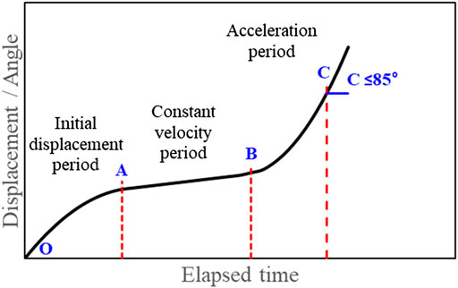
FIGURE 1. Landslide failure model and phased criteria setting points.

TABLE 1. Phased criteria setting points for the development of measurement management criteria.
The specific analysis method for these criteria is as follows. The “displacement/slope velocity” is calculated based on the velocity/slope displacement unit of the management criteria using the displacement data over time, and the “displacement/slope acceleration” is calculated based on the displacement/slope velocity. However, in the case of the end of the acceleration phase for determining the alert level, the maximum displacement/slope at which the displacement can be measured and the corresponding maximum acceleration values are generally calculated using the measured values. However, the measurement management criteria provide risk levels before considering the damage from failure; therefore, it is difficult to determine the alert level based on the end point of the acceleration phase. To complement this, Xu et al. (2011) analyzed the displacement/slope velocity at which a slope failure occurs using actual failure site data from Wang and Zhang (1999). The article found that the displacement velocity at slope failure may be converted into a slope angle of 89–89.5°. Based on this, the critical failure for pre-warning criteria of was to be 85°.
In this study, the polynomial model was utilized by applying the aforementioned criteria for four graded, initial displacement (O) for “watch,” start (A) and end (B) points of constant-velocity period for “caution,” “warning,” end point of acceleration (C) for “alert” in Table 1.
Domestic and overseas references, indoor experiments (including small- and full-scale flume experiments), and field data were analyzed to develop measurement-based management criteria for soil slope failure in this study. First, management criteria that can be used to examine the stability of slopes under construction were examined. Additionally, short-term–based management criteria considering short-term–based data, such as heavy rainfall over short time periods, and long-term–based management criteria considering the continuous measurement of the slope and soil were developed. Considering the short-term–based criteria, a slope failure experiment was conducted using small- and full-scale slope failure simulators at the National Disaster Management Research Institute. The surface behaviors were analyzed by installing a surface displacement gauge to verify the behaviors during the failure process. The values of phased management criteria were derived from the displacement measurement data, and the short-term–based management criteria were then developed. The final measurement-based management criteria were developed following the full-scale flume experiment considering the effects of scaling. The long-term–based management criteria were next developed by analyzing domestic and overseas references and field data of previous failures that have either occurred or are predicted to occur in South Korea.
The research on surface-angle–based measurement management criteria globally remains limited. Therefore, the surface-angle–based evacuation management criteria considered in this study were developed by analyzing the surface angle results acquired via the full-scale flume experiment at the National Disaster Management Research Institute.
Finally, the reliability of all management criteria was verified using small- and full-scale flume experiments with different conditions, as well as by considering the results of previous studies. The design and methodology of study is shown in Figure 2.
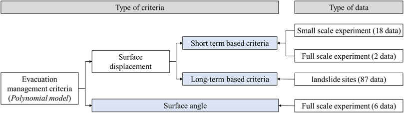
FIGURE 2. The design and methodology of this study.
The National Disaster Management Research Institute has a full-scale steep slope failure simulator. This full-scale steep slope failure simulator, which is the largest in Asia, is composed of an artificial rainfall reproduction device for reproducing rainfalls, a model container for constructing slopes, and a control room for the analysis of slope images and verification of the measurement results. The artificial rainfall reproduction device with a size of 4 × 21 m can reproduce a continuous rainfall across the entire slope, and the rainfall intensity can be adjusted from 10 to 160 mm. Furthermore, the injection method can be selected between left, right, and directly downward injections according to the experimental conditions. The model containers are divided into the first, second, and third containers, which have a variable structure in which the angle can be adjusted for different soil types. The first model container can be adjusted to 0–5°, the second model container to 0–15°, and the third model container to 15–40°. The soil layer can be built up to a height of 2.5 m, and soil can be piled up to approximately 250 t. Finally, the control room can adjust the rainfall intensity, method, and slope angle, as well as receive measurement data and acquire images. In addition, the National Disaster Management Research Institute has a small-scale slope failure simulator with a size that is 1/10 the scale of the large simulator.
A soil slope was constructed using the full-scale landslide failure simulator for landslide experiments and data acquisition. The soil used in this experiment was granite weathered soil that consists of 73.8% sand and 22% fine powder. The coefficient of uniformity (Cu) is 6.0, the coefficient of curvature (Cg) is 0.84, the liquid limit (LL) is 29.7%, and the plastic limit is 21.5%, so this soil is classified as SP. The engineering properties (friction angle and cohesion) of soil were measured to 32.1° for friction angle and 22.8 kPa for cohesion intercept. The bottom angle of the slope was 5° for the first model container, 15° for the second model container, and 35° for the third model container, and the surface angle of the slope was 35°. The dimensions of the slope size were 10.6 m in height, 15.2 m in length, 2.5 m in soil depth, and 4 m in width. The weight of the slope was approximately 220 t. When constructing the slope, the soil was built with a dry density of approximately 1.55 t/m3 and a water content of 10%. To measure the process of slope failure due to rainfall, three surface angle gauges were installed at the top (7.5 m), middle (6.3 m), and bottom (5.1 m) from the end of the slope. The surface displacement gauges were installed at the same heights as the surface angle gauges at approximately 1 m from the center of the slope (six gauges total). An imaging device was installed at the top front section of the slope to visually analyze the changes during the failure process.
Lastly, the rainfall was injected using the artificial rainfall reproduction device, and the rainfall intensity was set to 50 mm/h. Because the rainfall intensity (50 mm/h) was determined by average rainfall intensity (until slope failure) over six fields during typhoon “Mitag” in the year 2019. The coefficient of uniformity of the rainfall was 87.2%, which satisfied the reliability of the coefficient of uniformity for domestic and overseas rainfall devices (Jeong et al., 2019).
The slope dimensions, gauge types, and installation positions for the experiment are shown in Figure 3. This experiment was performed twice.
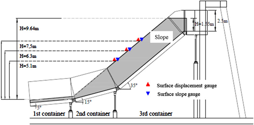
FIGURE 3. Geometry of the slope and gauge installation positions.
Closed-circuit televisions (CCTVs), surface displacement gauges, and surface angle gauges were used to analyze the surface behaviors and develop measurement management criteria. The CCTVs consist of nine cameras in total that can obtained videos at different locations and a recorder for recording videos. The surface displacement gauges are composed of a displacement sensor, a box that contains this sensor, and a fixture for fixing the displacement gauge. For the displacement sensor, a wire sensor (electrical resistance type) was used, which is widely used for surface displacement measurements. A device with a measurement range of up to 2,000 mm was used considering the scale of the empirical experiment. The measurement instrument and data logger for storing the data are interconnected by a wire. The surface angle gauge is composed of an integrated slope measurement instrument (composed of a slope gauge sensor and support) that can transmit data wirelessly, as well as a gateway that can send and receive the data. The slope gauge has an embedded battery, can measure 360° from the reference point, and has a resolution of 0.0001°.
A slope failure was induced by subjecting the above-described slope to a continuous rainfall. The images were acquired during the failure process, and measurements of the slope surface and surface displacement were acquired during failure. The analysis results of the imaging device and measurement instruments (slope surface and surface displacement) were obtained.
The imaging device results demonstrated that the failure behavior obtained via the first experiment occurred via a scour generated at the center approximately 20 min following the onset of rainfall, and the size and number of scours increased with time. Failure occurred at approximately 1000 min from the onset of rain. At the time of failure, a soil depth of approximately 1 m was generated. The failure behavior observed via the second experiment resulted from the generation of scours at approximately 25 min after the start of rainfall. The failure progressed similarly to that of the first experiment, but it progressed slower and occurred approximately 1300 min later the onset of rain. The final images of the slope failures are shown in Figure 4.
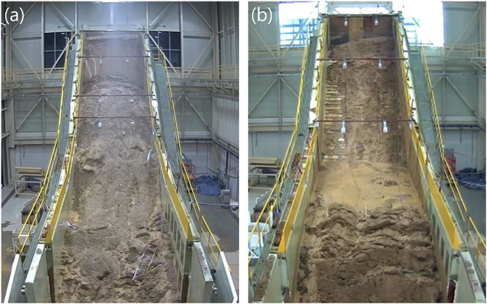
FIGURE 4. Images of the slope failure after each experiment: (A) first and (B) second experiments.
The results of the surface displacement analysis are shown in Figure 5A considering the surface displacement over time for the first experiment. The surface displacement behavior showed a tendency to increase either step-by-step or rapidly at various points during both the first and second experiments. In general, the bottom of the slope showed an abrupt increase, while a more gradual increase was observed toward the top. At the bottom of the slope, a rapid displacement occurred initially. Partial failure is considered to have occurred at the lower portion of the slope as saturation of the bottom portion of the slope occurred due to the continuous rainfall.
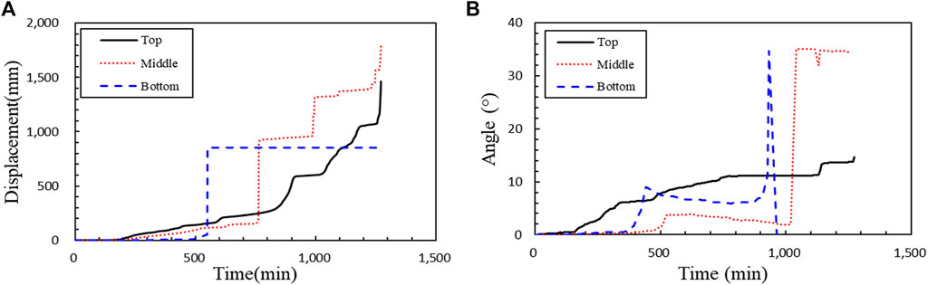
FIGURE 5. Surface behaviors by position over time: (A) surface displacement and (B) surface angle.
Finally, the surface angle analysis was conducted to investigate the variation of the slope angle over time as measured by the slope gauges, and the results are shown in Figure 5B. The slope angles in both experiments generally underwent cycles of increasing and decreasing over time. These results were likely obtained due to the creation of scours via the continuous rainfall. Furthermore, a rapid change occurred immediately before the slope failure, as was observed in the image analysis results. The slope angle partially increased or decreased over time depending on the section of the slope, while the slope angle at the actual failure point rapidly increased after slowly increasing.
For the surface-displacement–based measurement management criteria, short-term–based measurement management criteria that can be used to examine the stability of a slope under construction or applied when examining heavy rainfall over a short time period were considered. Moreover, long-term–based measurement management criteria that can be applied to soil slope and creep that require continuous management were developed. Furthermore, the reliability of the developed measurement management criteria was verified.
The short-term–based measurement management criteria were derived through 18 experiments using the small-scale slope failure simulator and two experiments using the full-scale slope failure simulator.
During the 18 small-scale experiments, measurements were performed while changing the rainfall intensity (30, 50, and 100 mm/h), slope gradient (35, 40, and 50°), and dry unit weight (1.30–1.50 g/cm3). Considering the measured data, four levels of management criteria were determined according to the criteria for each level described in Section 2. Therefore, “watch” (gray circle), “caution” (yellow triangle), “warning” (orange square), and “alert” (red diamond) were marked at the points corresponding to each level, as shown in Figure 6A. Regarding the results of the small-scale experiments, either the minimum or average values may be used to determine these levels. In this study, we utilized the hr. average values according to the method presented in the steep slope management practical handbook. The short-term–based management criteria obtained through the small-scale experiments were denoted as the point at which displacement first occurred for “watch,” 1 mm/min for “caution,” 5 mm/min for “warning,” and 31 mm/min for “alert.”

FIGURE 6. Phased management criteria points (surface displacement) obtained via (A) small-scale flume experiments and (B) full-scale flume experiments.
Next, two full-scale flume experiments were conducted using the conditions noted in Section 3, and the phased management criteria and averages were analyzed. The analysis method using the full-scale flume experiments was the same as that of the small-scale experiments. However, in the case of the full-scale flume experiments, the experimental time was approximately 18–21 h whereas it was ≤2 h for the small-scale experiments, and scours and partial failures occurred. Therefore, considering the measurement data of the full-scale flume experiments, the measurement management criteria were analyzed only using the data that was directly affected by failure (i.e., the final polynomial graph or total graph) instead of analyzing the entire experiment. Finally, the four aforementioned levels were indicated via this analysis. Figure 6B shows a figure of the phased management criteria points obtained using partial data of the full-scale experiment, and their values are shown in Table 2. The short-term–based measurement management criteria determined via the full-scale flume experiment were determined as the onset of displacement for “watch,” 1 mm/min for “caution,” 3 mm/min for “warning,” and 17 mm/min for “alert.”

TABLE 2. Results of the long-term–based evacuation management criteria (surface displacement).
To develop the short-term–based measurement management criteria through indoor experiments, the results of the small- and full-scale flume experiments were analyzed. It was found that the criteria determined through the small-scale experiments were higher than those determined through the full-scale flume experiments (except for “watch”). The average values of the small-scale experiments may have been greater due to large differences in the criteria values for each level considering various conditions (rainfall intensity, dry unit weight of soil, and slope angle). Moreover, it appears that the different amounts of time required for failure affected these results. The small-scale experiments were conducted over a relatively short period of approximately 2 h, whereas the full-scale flume experiments required more than 16 h. In the small-scale experiments, failure occurred relatively quickly and displacement occurred rapidly compared to the large-scale experiments due to size differences. Jeong et al. (2011) analyzed the progression of failure over time according to the sizes of the small- and full-scale flume experiments and confirmed that the small-scale experiment generated greater displacements over the same time period compared to the full-scale flume experiment.
Because the small-scale experiment cannot consider the scaling effects, the small- and full-scale flume experiments may not be directly compared. To address this problem, a weight (×2) was given to the results of the full-scale flume experiments, and the short-term–based measurement management criteria applicable to the soil slope were finally developed. Results show the short-term–based measurement management criteria determined through indoor experiments, which were the onset of displacement for “watch,” 1 mm/min for “caution,” 4 mm/min for “warning,” and 21 mm/min for “alert.”
The long-term–based evacuation management criteria were determined through the data analysis of measurements from eight domestic landslide sites (2012–2014). These data were used to determine the evacuation management criteria for landslides that occurred in 2016 by the Ministry of the Interior and Safety. We aim to improve upon these management criteria by using a different analysis method while considering the same data.
The conventional phased measurement management criteria apply one criterion for one data point, but this study determined multiple criteria for each level to reflect the actual behaviors of slope failure and improve the reliability of these criteria by considering more data. Figure 7A shows phased evacuation management criteria that were previously determined, whereas Figure 7B shows multiple phased evacuation management criteria points that were determined in this study. The evacuation management criteria shown in Figure 7B were determined using 87 data points instead of the eight data points used previously. As a result, “watch” was determined as the onset of displacement, “caution” as 2 mm/day, “warning” as 8 mm/day, and “alert” as 56 mm/day.
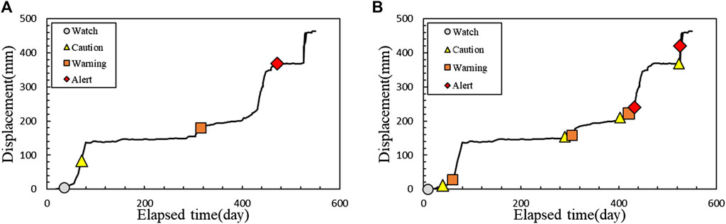
FIGURE 7. Phased management criteria points determined through an analysis of field measurement data: (A) previous analysis data [21] and (B) this study.
In this section, the short- and long-term–based evacuation management criteria developed in Sections 5.1 and 5.2 are verified. The short-term–based evacuation management criteria were verified using 10 small-scale flume experiments and two full-scale flume experiments with different experimental conditions. The soil used in these experiments was granite weathered soil with a specific weight of 2.59, liquid limit of 29.7%, plastic limit of 21.5%, and plasticity index of 6.8%. This soil was classified as SC-SM by the unified taxonomy, and the content of fine particles was analyzed to be approximately 38.0%. Furthermore, the slope conditions and positions of the measuring instruments were to the same as those in Section 5.2. The rainfall intensity was 50 mm/h, as in the previous experiments. The phased management criteria were calculated using the measurement management criteria method applied in this study using the displacement data measured during the 10 small-scale flume experiments and two full-scale flume experiments according to the above conditions. Figure 8 shows the phased criteria points according to the above experiments. The verified management criteria were determined to be the onset of displacement for “watch,” 1 mm/min for “caution,” 4 mm/min for “warning,” and 96 mm/min for “alert.” These criteria are greater than the values proposed in this study, which were onset of displacement, 1, 3, and 17 mm/min for “watch,” “caution,” “warning,” and “alert,” respectively. The criteria in this study were set more conservative than those for verification. Therefore, they are considered to be reasonable for application under various conditions.
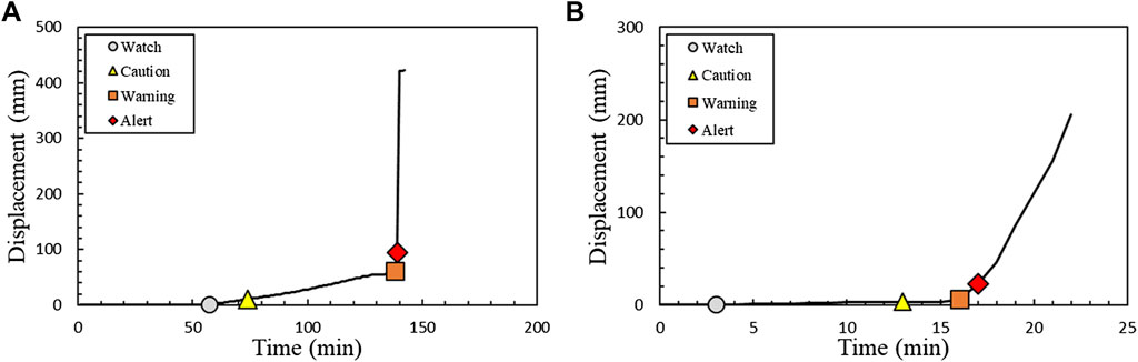
FIGURE 8. Phased management criteria points for verification (short-term perspective): (A) small-scale experiments and (B) full-scale flume experiments.
The long-term–based evacuation management criteria were verified through the surface-displacement–based measurement management analysis method that has been used both in Korea and elsewhere. The management criteria (mm/day) determined in previous studies that can be directly compared with the criteria proposed in this study were considered (Task Committee of Japanese Geotechnical Society (TCJGS), 1996; Japan Highways Organization (JHO), 1998; Ministry of the Interior and Safety (MOIS), 2015; Yoo, 2006; Yueping et al., 2010; Cheon et al., 2013). It was found that the average values of the management criteria were 7.4, 8.0, 19.2, and 84.5 mm/day for “watch,” “caution,” “warning,” and “alert,” respectively, as shown in Table 3.
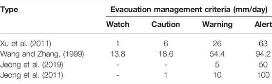
TABLE 3. Results of the long-term–based evacuation management criteria used for verification (surface displacement).
These criteria were more conservative than the long-term–based measurement management criteria proposed in this study, which were the onset of displacement, 2, 8, and 56 mm/day for “watch,” “caution,” “warning,” and “alert,” respectively. Therefore, the measurement management criteria determined in this study may be applied for various ground and geological conditions.
The surface-angle–based measurement management criteria were developed by analyzing the six surface angle datasets obtained using the experimental conditions described in Section 3.2. Figure 9 shows the results of the full-scale flume experiment over time. The measurement data showed a trend of slowly increasing after the onset of measurements and then rapidly increasing at a certain point. Therefore, according to the criteria defined in Section 2.1, the “watch” level was set to the onset of displacement, “caution” level to the beginning start of the constant velocity,” “warning” level to end point of the constant velocity, and “alert” level to the end point of the acceleration. The final surface-angle–based measurement management criteria were proposed by averaging the results of each dataset for each level. The final measurement management criteria for the full-scale flume experiment were determined as the onset of displacement for “watch,” 0.04°/min for “caution,” 0.22°/min for “warning,” and 1.74°/min for “alert.”
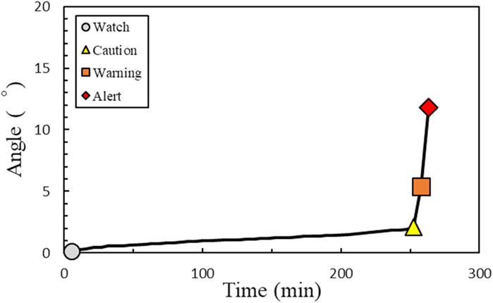
FIGURE 9. Phased management criteria points determined through the full-scale flume experiments (surface angle).
The surface-angle–based measurement management criteria developed in this Section 6.1 were verified. The results of the full-scale flume experiments conducted under the soil and experimental conditions described in Section 5.3 were used to verify the measurement management criteria, and the criteria determination method described in Section 6.1 was used as the verification method. Five datasets were analyzed through two full-scale flume experiments. As shown in Figure 10, the slope angle slowly increased after the onset of displacement and then rapidly increased. This trend was the same as the trend observed in Section 6.1. The final measurement management criteria were derived by averaging the individual data analysis results. As shown in Table 4, the “watch” level was determined as the onset of displacement, “caution” level as 0.04°/min, “warning” level as 0.18°/min, and “alert” level as 2.22°/min. These criteria were more conservative than those proposed in this study, which were the onset of displacement, 0.04, 0.22, and 1.74°/min for “watch,” “caution,” “warning,” and “alert,” respectively. Therefore, the measurement management criteria proposed in this study may be applied to various soil and geological conditions.
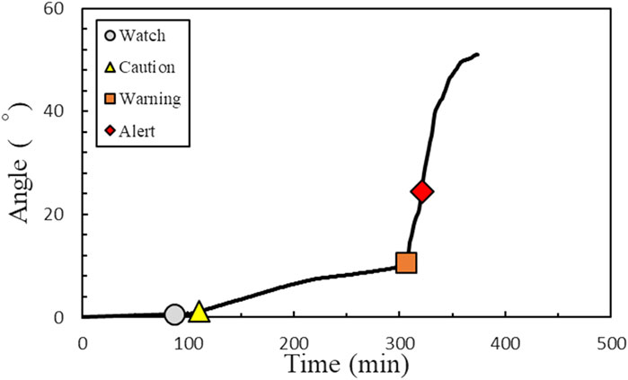
FIGURE 10. Analysis results for the verification of the measurement management criteria (based on the surface angle).
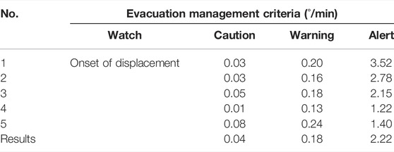
TABLE 4. Results of surface-angle–based evacuation management criteria for verification.
It should be noted that the surface-angle–based measurement management criteria proposed in this are not sufficiently reliable due to insufficient analysis data and a lack of existing research results. Therefore, it is recommended that the surface-angle–based measurement management criteria proposed in this study be used as supplementary criteria, for application to steep soil slopes where it is difficult to install surface displacement gauges.
The short-term–based evacuation management criteria were verified using 10 small-scale flume experiments and 2 full-scale flume experiments with different experimental conditions. The soil used in these experiments was granite weathered soil with a specific gravity of 2.59, liquid limit of 29.7%, plastic limit of 21.5%, and plasticity index of 6.8%. This soil was classified as SC-SM by the unified classification method, and the content of fine particles was approximately 38.0%. Furthermore, the slope conditions and gauge positions were similar to those in Section 5.2, and the rainfall intensity was set to 50 mm/h, as in the previous experiments. The phased management criteria were determined using the measurement management criteria method proposed in this study considering the displacement data measured via the small- and full-scale flume experiments. The final measurement management criteria for verification were determined, as shown in Table 4, which were the onset of displacement for “watch,” 0.04°/min for “caution,” 0.18°/min for “warning,” and 2.22°/min for “alert.” These criteria are greater than those proposed in this study, which were the onset of displacement, 1, 3, and 17°/min for “watch,” “caution,” “warning,” and “alert,” respectively. Therefore, the criteria proposed in this study were more conservative than the verification criteria, and the proposed criteria may be reasonably applied under various conditions.
Surface-displacement– and surface-angle–based management criteria were derived in this study by conducting failure experiments using surface displacement and surface angle gauges installed at the same positions. Therefore, the phased measurement times can be directly compared by analyzing the results of these two gauges.
Figure 11 shows the phased measurement management criteria determined based on the surface displacement and surface angle at the same height via empirical experiments. The displacement over time is indicated by the black line, and the phased measurement management criteria are indicated by the open symbols. The surface-displacement–based management criteria were calculated as approximately 170 and 1,238 min for the “caution” level, approximately 901 and 1,257 min for the “warning” level, and 1,172 and 1,260 min for the “alert” level. The slope angle over time is indicated by the blue dotted line, and the phased measurement management criteria are indicated by the closed symbols. The surface-angle–based management criteria were calculated as approximately 168 and 1,226 min for the “caution” level, 1,137 and 1,253 min for the “warning” level, and 1,142 and 1,274 min for the “alert” level. The two measurement management levels showed similar values of approximately 170 for the “caution” level, approximately 1,255 min for the “warning” level, and approximately 1,258 min for the “alert” level. By comparing these two measurement criteria systems, it was observed that the same management criteria for both the surface displacement and surface angle occurred at similar times. This confirmed that these two management criteria can be directly compared with and verified using one another, and the surface-angle–based management criteria can be used to supplement the surface-displacement–based evacuation management criteria.
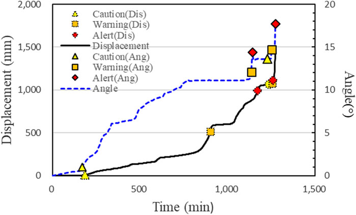
FIGURE 11. Comparison of the final management criteria for the surface displacement and surface angle at the same positions.
This study developed evacuation management criteria based on measurement data to minimize human casualties and property damage due to slope failures considering the criteria used by the Ministry of the Interior and Safety. Surface-displacement–based and surface-angle-based measurement management criteria that can analyze slope surface behaviors were developed. The results of this study may be summarized as follows:
1) Short-term–based measurement management criteria that can be applied to evaluate the stability of a slope under construction or heavy rainfall for a short period of time were developed. The management criteria were determined using small- and full-scale flume experiments, and a weight was given to the results of the full-scale flume experiments to improve the reliability of these experiments. The final short-term-based measurement management criteria proposed in this study were 1 mm/min for the “caution” level, 4 mm/min for the “warning” level, and 21 mm/min for the “alert” level.
2) Long-term–based measurement management criteria for application to soil slope and creep scenarios, which require continuous management, were also developed. These phased management criteria were determined by analyzing the results of domestic and overseas studies, as well as data from sites where failures have occurred or are predicted to occur. The final long-term–based measurement management criteria proposed in this study were 2 mm/day for the “caution” level, 8 mm/day for the “warning” level, and 56 mm/day for the “alert” level.
3) Surface-angle-based measurement management criteria were developed by considering the similarity between the surface angle and displacement behaviors. The measurement management criteria were determined for the four levels of watch-caution-warning-alert based on a polynomial model. The phased measurement management criteria were proposed as the onset of displacement for “watch,” 0.04°/min for “caution,” 0.22°/min for “warning,” and 1.74°/min for “alert.” Furthermore, the reliability of these criteria was verified via comparison with the results of empirical experiments conducted using varied experimental conditions. However, the surface-angle-based measurement management criteria proposed in this study exhibited reliability issues due to insufficient analysis data and a lack of existing research results. Therefore, it is recommended that these criteria be used to supplement the surface-displacement–based measurement management criteria or be applied to steep soil slopes where it is difficult to install surface displacement gauges.
The raw data supporting the conclusion of this article will be made available by the authors, without undue reservation.
Conceptualization: CS-G, SJ-W, and JM-S; Methodology: KH-S and JH-S; Formal Analysis: CS-G, KH-J and JH-S; Writing/Original Draft Preparation: CS-G; Writing Review and Editing: SH-S; Supervision: SH-S.
This research was supported by the project “Development of Slope Disaster Vulnerability Assessment based on Empirical Experiments (Ⅱ)” (No. NDMI-PR-2022-07-02) from the National Disaster Management Research Institute (NDMI).
The authors declare that the research was conducted in the absence of any commercial or financial relationships that could be construed as a potential conflict of interest.
All claims expressed in this article are solely those of the authors and do not necessarily represent those of their affiliated organizations, or those of the publisher, the editors, and the reviewers. Any product that may be evaluated in this article, or claim that may be made by its manufacturer, is not guaranteed or endorsed by the publisher.
Bazin, S. (2012). Guidelines for Landslide Monitoring and Early Warning Systems in Europe – Design and Required Technology. Vienna, Austria: Safeland, Deliverable D4, 8.
Cheon, D.-J., Park, Y.-J., Lee, S.-H., Kim, J.-S., and Jung, D.-Y. (2013). The Development of Landslide Predictive System Using Measurement Information Based on U-IT. J. Korea Academia-Industrial Coop. Soc. 14, 5115–5122. doi:10.5762/KAIS.2013.14.10.5115
Choi, J.-H., Kim, H.-T., Oh, J.-Y., and Kim, Y.-S. (2011). Analysis of the Controlling Factors of an Urban-type Landslide at Hwangryeong Mountain Based on Tree Growth Patterns and Geomorphology. J. Eng. Geol. 21 (4), 281–293. The Korean Society of Engineering Geology. doi:10.9720/kseg.2011.21.4.281
Choi, S.-G., Jeong, H., Song, H.-S., Kwon, T.-H., Kim, Y., and Lee, J.-M. (2019). Study of Korea Early Warning System for Slope Failure. J. Korean Soc. Hazard Mitig. 19, 73–81. doi:10.9798/KOSHAM.2019.19.5.73
Jang, S.-J., Lee, Y.-T., Lee, K.-Y., Kim, K.-N., Lee, J.-H., and Chun, K.-W. (2020). A Study of Disaster Prevention and Characteristics of Landslides Triggered by the 2019 Typhoon Mitag in Samcheok. J. Korean Soc. Hazard Mitig. 20, 221–227. doi:10.9798/KOSHAM.2020.20.2.221
Japan Highways Organization (Jho) (1998). Design Guideline, Tokyo, Japan: Japan Highways Organization, 1–37.
Jeong, H. S., Kang, H. S., Suk, J. W., and Kim, H. J. (2019). Rainfall Distribution Characteristics of Artificial Rainfall System for Steep-Slope Collapse Model Experiment. J. Korea Acad.-Ind. Coop. Soc. 20, 828–835. doi:10.5762/KAIS.2019.20.12.828
Jeong, J., Ji, Y., Kim, Y., and Lee, S. A. (2011). Study on the Scale Effect of Landslide Model Test. Korean Geo-Environmental Soc. 12, 5–12.
Kang, H.-S., and Kim, Y.-T. (2015). Study on Physical Vulnerability Curves of Buildings by Numerical Simulation of Debris Flow. J. Korean Soc. Hazard Mitig. 15, 155–167. doi:10.9798/KOSHAM.2015.15.5.155
Kim, J., Kim, Y., Jeong, S., and Hong, M. (2017). Rainfall-induced Landslides by Deficit Field Matric Suction in Unsaturated Soil Slopes. Environ. Earth Sci. 76, 1–17. doi:10.1007/s12665-017-7127-2
Kim, M.-I., Kwak, J., Jun, B., and Kim, N. (2019). Analysis of Landslide Risk Distribution Pattern under Extreme Precipitation. J. Korean Soc. Hazard Mitig. 19, 105–112. doi:10.9798/KOSHAM.2019.19.3.105
Kim, Y., and Jeong, S. (2017). Modeling of Shallow Landslides in an Unsaturated Soil Slope Using a Coupled Model. Geomechanics Eng. 13 (2), 353–370. doi:10.12989/GAE.2017.13.2.353
Kim, Y., Rahardjo, H., Nistor, M. M., Satyanaga, A., Leong, E.-C., and Sham, A. W. L. (2022). Assessment of Critical Rainfall Scenarios for Slope Stability Analyses Based on Historical Rainfall Records in Singapore. Environ. Earth Sci. 81, 39. doi:10.1007/s12665-021-10160-4
Lee, C. H., Eo, G., Lee, S. H., Oh, K. R., and Sim, O. B. (2018). Development of Multilayer Defense System Recovery Techniques for Flood and Landslide: For Residential and Industrial Complex in Chuncheon City. J. Korean Soc. Hazard Mitig. 18, 123–131. doi:10.9798/KOSHAM.2018.18.6.123
Lee, C., Youn, H. J., and Woo, C. S. (2009). Development and Verifying of Calculation Method of Standard Rainfall on Warning and Evacuation for Forest Soil Sediment Disaster in Mountainous Area by Using Tank Model. Jour. Korean For. Soc. 98, 272–278. (in Korean).
Ministry of the Interior and Safety (Mois) (2015). The R&D Research on Construction of Monitoring Management System for Evacuating Inhabitant in Steep Slope Site and Development of Monitoring Specification. Sejong, Korea: Ministry of the Interior and Safety.
Ministry of the Interior and Safety (Mois) (2016). Guideline of Steep-Slope Management. (in Korean) Sejong, Korea: Ministry of the Interior and Safety.
Park, S.-J., Lee, C.-W., Lee, S., and Lee, M.-J. (2018). Landslide Susceptibility Mapping and Comparison Using Decision Tree Models: A Case Study of Jumunjin Area, Korea. Remote Sens. 10, 1545. doi:10.3390/rs10101545
Popescu, M. E. (2002). “Landslide Causal Factors and Landslide Remediation Options,” in 3rd International Conference on Landslides, Slope Stability and Safety of Infra-structures, Singapore, 61–81.
Reid, M. E., LaHusen, R. G., and Ellis, W. L. (1999). Real-Time Monitoring of Active Landslides. Reston, Virginia: United States Department of the Interior, United States Geological Survey.
Song, Y. S., and Hong, W. P. (2007). A Case Study on the Analysis of Cause and Characteristics of a Landslide at the Sedimentary Rock Area. J. Eng. Geol. 17 (1), 101–113. The Korean Society of Engineering Geology.
Task Committee of Japanese Geotechnical Society (TCJGS) (1996). Manual for Zonation on Rain-Induced Slope Failure. Tokyo, Japan: Japanese Geotechnical Society.
Wang, J. D., and Zhang, Z. Y. (1999). Systematic Project Research on Typical High Speed Loess Landslide (In Chinese). Chengdu: Sichuan Science and Technology Publishing House, 140–153.
Xu, Q., Yuan, Y., Zeng, Y., and Hack, R. (2011). Some New Pre-warning Criteria for Creep Slope Failure. Sci. China Technol. Sci. 54, 210–220. doi:10.1007/s11431-011-4640-5
Yoo, B. S. (2006). A Study of Failure Analysis Methods Based on Real-Time Monitoring Data for Landslide Warning System. Ph.D. Thesis. Gumi, Korea: Kumoh National Institute of Technology.
Keywords: landslide, evacuation management criteria, surface displacement, surface angle, full-scale experiment
Citation: Choi S-G, Jung M-S, Suk J-W, Kim H-J, Kang H-S, Jeong H-S and Song H-S (2022) New Evacuation Management Criteria for Potential Landslides Based on Experimental Studies. Front. Environ. Sci. 10:957842. doi: 10.3389/fenvs.2022.957842
Received: 31 May 2022; Accepted: 23 June 2022;
Published: 24 August 2022.
Edited by:
Snehasis Kundu, National Institute of Technology, IndiaReviewed by:
Yongmin Kim, University of Glasgow, United KingdomCopyright © 2022 Choi, Jung, Suk, Kim, Kang, Jeong and Song. This is an open-access article distributed under the terms of the Creative Commons Attribution License (CC BY). The use, distribution or reproduction in other forums is permitted, provided the original author(s) and the copyright owner(s) are credited and that the original publication in this journal is cited, in accordance with accepted academic practice. No use, distribution or reproduction is permitted which does not comply with these terms.
*Correspondence: Hyo-Sung Song, c29uZzMyQGtvcmVhLmty
Disclaimer: All claims expressed in this article are solely those of the authors and do not necessarily represent those of their affiliated organizations, or those of the publisher, the editors and the reviewers. Any product that may be evaluated in this article or claim that may be made by its manufacturer is not guaranteed or endorsed by the publisher.
Research integrity at Frontiers
Learn more about the work of our research integrity team to safeguard the quality of each article we publish.