 Li Liu1†
 Xiujuan Zhang
94% of researchers rate our articles as excellent or good
Learn more about the work of our research integrity team to safeguard the quality of each article we publish.
Find out more
ORIGINAL RESEARCH article
Front. Environ. Sci., 08 June 2022
Sec. Environmental Economics and Management
Volume 10 - 2022 | https://doi.org/10.3389/fenvs.2022.944936
This article is part of the Research TopicTechnology-Enabled Circular Economy Practices in Energy Production and Consumption PatternsView all 23 articles
In this paper, the spatial distribution maps of Sanmen Bay’s landscape genres between 1995 and 2020 were drawn based on spectra, GPS data, and the genres’ information extracted through remote-sensing imagery, in a way to fundamentally evaluate the region’s coupling and coordinated development. Moreover, to provide a science-based reference point for protecting and utilizing the Bay’s wetlands, changes of landscape genres were examined through a transition matrix, and the drivers of these dynamics were analyzed on a Logistic regression model. In addition, a theoretical and appraisal system compatible with the comprehensive evaluation of a bay’s ecosystem was built upon the analysis of Sanmen Bay’s land and sea areas. This would provide a scientific basis for bay ecosystem preservation by complementing the theoretical architecture of comprehensively evaluating a bay’s environment and keeping the evaluation more timely and complete. Beyond that, we investigated the region’s social development and its spatial improvement over the marine economy from the perspective of a bay’s coupled society-economy-ecology system, which took into account manifest and latent environmental factors that have been absent in conventional bay development planning. Finally, through empirical analysis, to improve the social and economic landscape of Sanmen Bay provides effective policy recommendations, the study also made new efforts to explore and promote the sustainability of China’s Gulf ecosystem.
As an area of various marine resources, a bay is of importance to absorb pollutants, purify water, and regulate climate (Chen et al., 2007; Khan et al., 2021a; Yang et al., 2021). Meanwhile, it constitutes an integral part of the socio-economic growth of coastal cities that see common human activities, providing the vital living landscape and ecosystem services for regions (Hou et al., 2016; Jones and Wynn, 2021; Liu et al., 2021; Seetharaman et al., 2022). By leveraging the advantageous geolocations, natural environments, and vast hinterlands of ports and bays, the bay area economy is featured by an open economic structure, strong international collaboration, and well-positioned to allocate and pool resources effectively. As the China-proposed Belt and Road Initiative and the development plans of coastal provinces and cities are being implemented, the bay area economy has already developed into a new force driving the marine economy and enhancing its overall strength. In the context of prosperity in common policy, for instance, the Zhejiang Greater Bay Area (ZGBA) constructing in common prosperity demonstration zone must build upon a traditional bay area and grow sustainable if it is to take the lead in constructing a scenic metropolitan gateway. On this note, ZGBA is designed to shape a pioneer area for common prosperity in a new era. Ocean utilization, as was made clear at the 19th National Congress of the Communist Party of China in 2017, needed to center on coordinated land and marine development, and the guiding principle for growing the new-type marine economy and ultimately building China into a strong maritime country was articulated. ZGBA and the Hangzhou Greater Bay Area (HGBA) have epitomized the coordinated growth of Zhejiang’s six greater bay areas, and as their collaborated innovation systematically grows, ZGBA is on track to become a world-class bay area. As a typical planned bay area in ZGBA, Sanmen Bay serves as a bridge for the building of ZGBA as a whole. Unlike HGBA, Sanmen Bay, which covers the counties of Sanmen and Ninghai, borders Xiangshan Harbor and stimulates the development of Ningbo, Taizhou, and Wenzhou, remains to be further explored, thus calling for a new ocean development solution when it comes to utilizing and preserving marine resources (China Bay Record Committee, 1992).
The deep blue sea and white sands are just as valuable as gold and silver. The philosophy must always be upheld in developing the Ningbo-Taizhou-Wenzhou port industrial belt, and the green development enshrined in Sanmen Bay’s ecosystems, economy, and society must be reflected in all aspects of utilizing and conserving the marine environment.
Over the past four decades, the consistent policy of reform and opening-up has contributed to a soaring regional economy. That, however, has inevitably resulted in unignorable ecological degradation in several bay areas and coastal zones in Zhejiang. These environmental concerns include lower underground water levels, deteriorated hydrogeological conditions, disintegrated foundation and compaction material pollution in reclaimed areas, and worse seawater quality and marine pollution, coupled with increasing land reclamation projects for greater land supply driven by an excessively growing population and more threats to the survival and sustainability of mangrove forests (Xu et al., 2021). The underlying “gold and silver” environmental philosophy must be upheld if we are to foster harmonious and sustainable bay areas, give full play to the inner force of the Maritime Silk Road, and tap the potential of building a community with a shared future for humankind. The significant philosophy has a role in growing the marine environment and must be firmly followed through. Therefore, green development should be pursued as we build the Ningbo-Taizhou-Wenzhou port industrial belt, economically and socially (Jiao, 2001). As a large semi-enclosed Bay dotted with various islets and abundant in aquatic products, mudflats, the tide, and ports (Zhou et al., 2021; Yu et al., 2022) in Zhejiang Province, Sanmen Bay enjoys enormous potential to grow the bay area economy since it connects Hangzhou Bay to the Wenzhou-Taizhou Economic Corridor. Nonetheless, its self-purification capacity is weak, and the environment is fragile due to its semi-enclosed landform. Beyond that, conflicts (Song et al., 2017; Wang et al., 2022a) among polderization, farming on mudflats, and port building put the carrying capacity of the Bay’s ecosystem services at risk, thus holding back its sustainable development. All these realities can be found in the chronological changes in Sanmen Bay’s landscape genres, which show the thread of the Bay’s socio-economic development and ecological progress and major events that occurred. And the application of various remote-sensing data, particularly the high-precision Chinese-developed “Gaofen” satellite data, can readily produce the imagery of the Bay’s typical studied areas in different periods to identify and compare surface features. This requires an investigation for fundamentally understanding the Bay’s development landscape and, more importantly, the scenario analysis of different models mixing society and economy with ecology. This is how we can step aside misunderstanding and put its growth on a fast track.
Situated at the mid coastal area of Zhejiang Province and China’s mid-shoreline, Sanmen Bay (28°57′–29°22″N, 121°25′–121°58″E) is surrounded by Jinqimen Village, Sanmen Island, and Niutou Mountain, overlooking the East China Sea, and under the jurisdiction of Taizhou and Ningbo (Figure 1). As one of the province’s three semi-enclosed bays, Sanmen Bay borders Xiangshan Harbor to the north and Taizhou Bay to the south. Surrounded by lands on three sides, the palm-shaped Bay spans from northwest to southeast and connects the ocean through Shipu Watercourse, north of Jianyang Island. The distance between its mouth and top is approximately 40 km, and the width of the mouth ranges from about 22 km (between Nanshan Mountain and Qingyu Mountain) to around 10 km (between the Niushanzui water area and Hua’ao Island) (Xia and Xie, 1996). As a natural bay and, more specifically, a bedrock erosion-stacking bay, Sanmen Bay boasts abundant water resources, with the water area accounting for 62% of its total area, and a shape coefficient of 0.4 makes it a narrow strip.
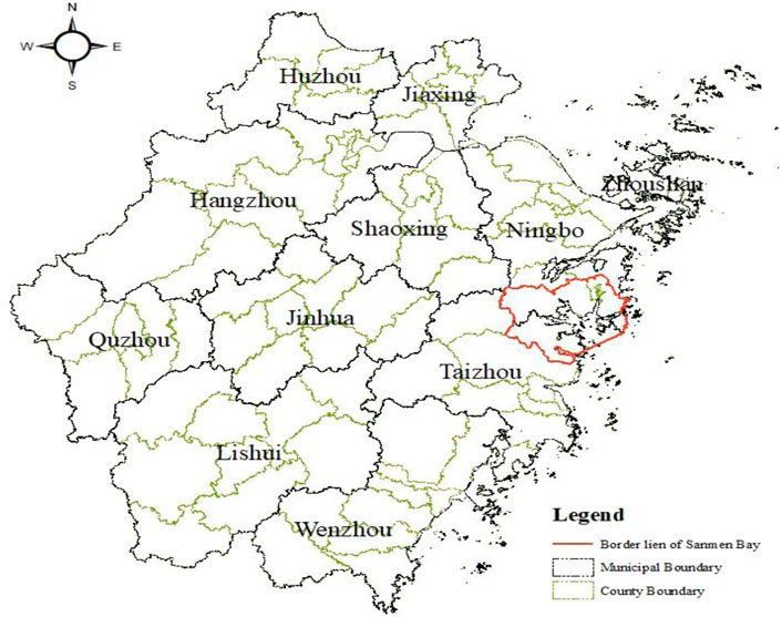
FIGURE 1. Geographical map of Sanmen Bay.
The southwest bank of Sanmen Bay is under the jurisdiction of Sanmen County, Taizhou; its west bank belongs to Ninghai County, Ningbo; its north bank is governed by Xiangshan County, Ningbo. In total, the Bay covers 33 towns/townships, including 14 in Sanmen (namely Huaqiao, Lipu, Xiaoxiong, Jiantiao, Hengdu, Zhu’ao, Tingpang, Haiyou, Shaliu, Liu’ao, Gaoshi, Silin, Yanchi, and Shepan), 11 in Ninghai (namely Yishi, Sangzhou, Qiantong, Huangtan, Chalu, Changjie, Liyang, Chayuan, Huchen, Yuexi, and Yuelong Sub-district), and eight in Xiangshan (namely Dingtang, Xinqiao, Hepu, Shipu, Sizhoutou, Xiaotang, Maoyang, and Gaotangdao) (Figure 2). Those flowing to the Bay are mainly mountain streams, such as Zhuyou and Tingpang streams in Sanmen, and Zhongbao Stream in Ninghai, as well as Qingxi and Baixi shared by the two counties. Given the reality of the Bay’s water system, its surrounding area is divided into seven watersheds (named Puba, Jiantiao, Haiyou, Qimen, Liyang, Baijiao, and Shipu) (Zhang et al., 2013; Yang and Chen, 2018).
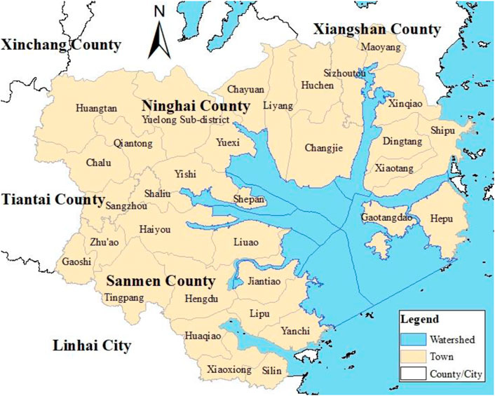
FIGURE 2. Administrative map of Sanmen Bay.
The coastal areas in Sanmen Bay boast a developed social economy, with its counties of Xiangshan and Ninghai ranking 63rd and 89th, respectively, according to the list of top 100 counties or cities by the socio-economic growth index. That shows that its surrounding areas are economically strong. To be specific, Xiangshan is a shipbuilder and a producer of clothes, knitting, and electrical products; Ninghai specializes in automobile maintenance and the production of light fixtures, stationery, and molds; Sanmen, a county, is proud of its handicrafts, rubber manufacturing, and machine building. With a different industrial focus, though, they have a weak influence on each other. Meantime, the Bay has yet to be fully urbanized and is dotted with a majority of small cities. That means it cannot stimulate the development of its neighboring region as it falls short of the economic support from large and medium-sized cities. Furthermore, many small designated towns scattering across the Bay means a lack of cohesion and stimulation, thus disrupting the influx of capital into towns and infrastructure construction.
Sanmen Bay is rich in marine resources, among which fisheries, ports, mudflats, and tourism are significant to local economic development. Ocean industries comprise both traditional port transportation and emerging forms of business, such as coastal tourism and sea farming. Beyond that, the economically developed coastal counties and cities are joined by a growing port industry, thriving marine fisheries, and emerging oceanic tourism. Among the industrial structures of coastal counties and cities, the proportion of the primary industry is lower than 20%, while that of the secondary industry is higher than 50% in Xiangshan and Ninghai (excluding Sanmen). And the tertiary industry accounts for one-third of the economy. Overall, the Bay is not playing its due role in growing a featured marine economy, and the abundant marine resources it has to offer are not well leveraged, resulting in a waste of some resources. The Marine Function Zoning of Zhejiang Province makes clear that Sanmen Bay’s sea areas should focus on coastal tourism and the ecological port-centered industry and that efforts should be made to control land reclamation and explore the establishment of a mechanism for coordinated management of cross-administrative regions. And the Plan for Sanmen Bay (2009–2030) states that the Bay is designed to grow into an ecological, livable place for emerging industries and a scenic city cluster with a strong economy and a harmonious society. Also, the blueprint sets out the strategy of building the Bay into a growth driver of “Zhejiang at Sea” (Lu, 2013; Yao and Huang, 2015).
The research data in this paper mainly include digital image data, socio-economic data, and environmental survey reports. Among them, digital image data cover the land-use data of Zhejiang Province spanning from 1995 to 2005 (provided by China’s National Earth System Science Data Sharing Infrastructure—Yangtze River Delta Branch) and in 2015, remote sensing images of Sanmen Bay between 1995 and 2020 and ASTER GDEM. Socio-economic data encompass the statistics yearbooks of counties and cities; environmental survey reports contain bulletins on marine fisheries and marine environment and pollutant surveys. Specifics can be found in Table 1.

TABLE 1. Data specifics.
Landsat images in 1995, 2005, and 2015 were used as data sources, and the 2015 GF1 satellite images and google earth imagery were employed for correction and assisted interpretation of Landsat imagery.
Following pretreatment, all the remote-sensing data displayed the band combinations of Landsat images (RGB 543, RGB 941, or RGB 432) via visual interpretation. The spatial configuration and Type of the Sanmen Bay shoreline were extracted with reference to the coastline interpretation marks in the Technical Specifications for Coastline Surveying and the coastline classification system under the Technical Specifications for Surveying on Island Coasts with Satellite Remote Sensing, combined with such features (Zhou et al., 2020) as the color, vein and material components of the shoreline and on-site investigation documents. Mudflats near the shore are transitional zones, where the marine ecosystem is interwoven with its terrestrial counterpart. As provided by the Ramsar Convention on Wetlands of International Importance, the depth of coastal wetlands from the sea level shall not exceed 6 m. The depth of water in Sanmen Bay fluctuates as the water turns to be increasingly shallower from the mouth to the top of the Bay. If the 6-m-depth contour is applied to define the exterior boundary of the coastal mudflats, the area delineated will be much larger than the area in real terms. As a result, considering tidal dynamics, mudflat silting, among other factors, the paper used the 0-m-depth contour to define the exterior boundary for research on the coastal mudflat. The first step for research on spatial-temporal changes of off-shore mudflats is classification. However, currently, there is no universally recognized and clear-cut provision governing mudflat classification in the world.
Therefore, the Sanmen Bay landscape genre classification system was built on reference to relevant documents, China’s National Standard for Current Land Use Classification, and Anderson’s land use classification system in combination with the realities of the natural ecosystem and land use of Sanmen Bay (Figure 3). The approach of supervised classification to extract and identify the information on the types of landscape falls short of ensuring the precision of the information extracted, whereas visual interpretation is both time- and labor-consuming, In accordance with the Sanmen Bay land use classification system and with reference to the historical images of Google Earth, the paper applied the two approaches in unison to the extraction of the vector information on land use of Sanmen Bay so as to grasp the spatial-temporal changes in landscape genres of Sanmen Bay. The result of primary classification was calibrated on the basis of an on-site survey and high-resolution imagery. According to the sample test, 90% of the classification was precise in accordance with data of Google Earth and on Zhejiang’s land use. ArcGIS overlay analysis and spatial calculation were used to measure the indices of changes in the shoreline, mudflat reclamation intensity, and landscape genres of Sanmen Bay.
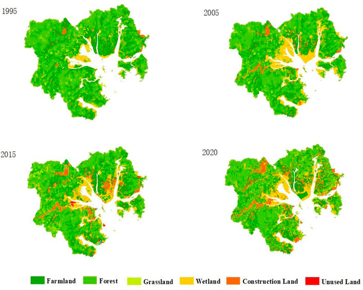
FIGURE 3. Diagram of processing remote-sensing data.
The Logistic regression model is a statistically classified probability model that is discrete in time, space and condition, and features spatial interaction and temporal causality. It has a strong capacity for complicated and parallel computing, characterized by highly dynamic property and spatial concepts. It is designed for the prediction of binary response of a certain class of dependent variables to one or more independent variables (Su et al., 2016). It often adopts the receiver operating characteristic (ROC) curve to examine the Logistic regression model’s interpretation capacity. Usually, the ROC value ranges from 0.5 to 1. A greater ROC value indicates stronger interpretation capacity. Its basic principle is well-grounded in calculating the probability of the genre of each grid unit, denoting the target variables with the binary variable data, and identifying the quantitative relationships between target variables through explanatory variables (including various social drivers) (Wang et al., 2022b). The model can be expressed as follows:
Where P is the probability of the occurrence of Type i; X represents a driving factor; n denotes the number of driving factors; β0 is a constant; β1∼βn suggests the partial regression coefficient in the Logistic regression equation, with a greater value accompanied by a stronger correlation between Type i and each driving factor.
The Logistic regression model is a grid-based spatial probability model, where the predicted values cannot be used in subsequent analysis. Widely applied in the prediction of land-use changes, the model is built on a basic principle designed to denote the binary probability of a certain type of decision or result (Khan et al., 2021b). Hence, in building the Logistic regression model, the study considered historical changes in the landscape genres of the Bay and the impacts of other factors, simulated changes in landscape genres dynamically, screened those factors indicative of comparatively great influence on the changes in the genres and eased the rest to stand better placed to predict the changes.
The spatial distribution maps of Sanmen Bay’s landscape genres between 1995 and 2020 were drawn based on spectra, GPS data, and the genres’ information extracted through remote-sensing imagery and UVA pictures (Figure 4).

FIGURE 4. Diagram of Sanmen Bay’s landscape genres in 1995, 2005, 2015, and 2020.
As shown in Figure 4, the 1995–2020 period saw a remarkable change in land use across the region, as evidenced by a significant increase in the areas of construction land and wetland, a reduction in farmland and forest areas, and a fluctuation in grassland areas. Specifically, the area of construction land expanded from 58.3 km2 in 1995 to 277.05 km2 in 2020, and that of wetland soared from 132.16 to 313.12 km2 in the same period. This was attributed to more frequent socio-economic activities by humans in the region after 2000, resulting in some off-shore mudflats used for farming and deep-water harbors converted into piers. Some mudflats disappeared after the construction of sea embankments and degraded into salt pans or farming areas over time. Since the founding of New China, people have begun land reclamation and enclosure by branching streams. Between 2005 and 2015, a majority of reclamation projects were launched at the top area of Sanmen Bay, which occupied 30% of the total reclaimed area. These projects mainly involved the tidelands of Shepan and Xiayang and the mudflats of Yangshi and Yanzhan in Jiantiao Port. The forest area plunged from 1,622.93 km2 in 1995 to 1,264.91 km2 in 2020. The trend of a shrinking grassland area slowed down between 1995 and 2005 before being reversed from 2005 onwards.
To further explore how the Bay’s landscape genres have changed, we employed a land-use transition matrix to examine the changing genres between 1995 and 2020 (Table 2).
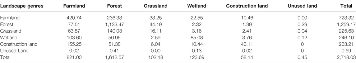
TABLE 2. Transition matrix on Sanmen Bay’s landscape genres from 1995 to 2020 (km2).
Table 3 shows that among areas of land-use changes in Sanmen Bay between 1995 and 2020, the area of farmland converted from the forest was the largest, at 236.33 km2, followed by 155.25 km2 of construction areas transformed from farmland and 140.03 km2 of the forest-turned grassland. That demonstrates the past 25 years saw accelerating urbanization and a surge in demand for land, which has turned vast forests into farmland and farmland into construction areas, ultimately making forests suffer. That is how dramatic changes to the Bay’s landscape genres have been made.
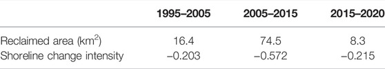
TABLE 3. Intensity of Sanmen Bay’s shoreline change between 1995 and 2020.
Sanmen Bay is a semi-enclosed bedrock bay abundant in islands but deficient in coastal land resources. Since the founding of New China, especially in the 1980s, the Bay has witnessed rapid population growth. In response to the shortage of land and freshwater resources, large-scale land reclamation projects were rolled out principally for the purpose of land tillage and freshwater storage via port blockade. On a large scale are the reclamation projects of Xiayang Mudflat, Shepan Mudflat, and Yanzhan Mudflat. Situated in the northeast of the Bay’s top area, the Xiayang Mudflat project benefits the towns of Liyang and Changjie and is designed for sea farming and cultivation. The reclaimed area, coupled with a tide gate and a check gate, becomes more capable of withstanding storm surges in a way that lowers construction costs and delivers socio-economic benefits. The project has not only offered a lot of land resources, but created more space for the development of the new coastal region in the south of Ningbo. Shared by the counties of Ninghai and Sanmen, the Shepan Mudflat project comprises two seawalls, namely South Seawall that starts at Dongsha Town in Ninghai and runs eastward to the Phase-III seawall in Shepan, and North Seawall that travels from the foot of Shuangpan Mountain to Shepan’s Phase-III seawall. Positioned to commercialize ecological cultivation, the area centers on national wetland parks and modern parks for ecological fisheries. The Yanzhan Mudflat project borders the ports of Qimen and Haiyou and connects Huagu Island, Yanzhan Mudflat, and Lanman Mudflat with the land in a bid to create more construction areas for the coastal new town in Sanmen County. Apart from the above-mentioned projects, Sanmen Bay also boasts Yangshi Mudflat for sea farming and the Niushan Thermal Power Plant for industrialization, as well as the reclaimed areas of Sanshan Mudflat and Shuangpan Mudflat (Phase II).
Remarkable changes (Figure 5) have been made to the shoreline of Sanmen Bay at different times due to the interplay of activities caused by the land, sea, and humans. Reclamation activities are the main reason that the straight muddy-soil shoreline of Sanmen Bay has been artificially twisted and shortened between 1995 and 2020. Due to intensifying economic activity (such as farming on mudflats, sightseeing tourism, and city building), the volatility of the man-made shoreline increases, while that of the natural one declines, and overall, the shoreline is becoming shorter. Overlay analysis showed that the Bay’s coastal areas had been expanding to a varying degree. Specifically, shoreline changes between 1995 and 2005 were mainly in the south of Ninghai and the north of Sanmen. For instance, Shepan Island and Huagu Island in north Sanmen turned into Shepan Town and Hairun Sub-district, respectively, due to their connection to the mainland, which was attributed to the land reclamation and sea farming projects. The 2005–2020 period saw an increase of 24.1 km in shoreline, which resulted from land reclamation projects that either expanded the land or linked islands to the mainland. Shoreline changes in this period could be found in the south of Ninghai, such as the reclaimed areas of Shepan Mudflat and Xiayang Mudflat. The Xiayang Mudflat project contributed to the integration of Xiayang Mudflat with Changjie Town, Ninghai, and the newly-established zone has served as a core industrial development area of the new coastal town in south Ningbo.

FIGURE 5. Diagram of reclaimed areas in Sanmen Bay between 1995 and 2020.
Designed to enlarge the land area, land reclamation projects have been an important measure to ease the shortage of land, gain momentum for agricultural growth, and produce more space for economic development. Projects on land reclamation and freshwater storage ensure more supply of land and water resources, but at the cost of the local marine environment. On top of that, malmanagement would render some reclaimed areas useless. For instance, farmers were supported and subsidized by local land authorities to plant crops on these reclaimed lands. But due to poor land quality and less economic benefits, these farmers preferred aquafarming to crop planting. The conflict between the two parties resulted in reclaimed areas lying in waste, a tremendous waste of marine resources.
To quantify the change and intensity of land reclamation in the studied area, indicators including the reclaimed area and the intensity of shoreline change were adopted, and their absolute values were used to demonstrate how the shoreline has varied. With that, the reclaimed area and intensity of shoreline change in Sanmen Bay between 1995 and 2020 are shown in Table 3.
As is displayed in Table 3, in terms of the spatial layout, Sanmen Bay’s shoreline saw a major change in hidden inner-bay areas, including the mudflats of Sanshan, Xiayang, and Shepan. Chronologically, land reclamation activities and shoreline changes varied at different stages, with the intensity of changes ranging from −0.203% to −0.572%. Since the founding of New China, large-scale reclaimed areas in this region have been used for the development of livestock, leading to a larger proportion of farmland. The trend had, however, threatened to destroy the environment, particularly since the 1990s. With more awareness of environmental protection came the more science-based development of the cultivation industry. With that in mind, harbor-related resources were tapped, and such forms of business as shipping, piers, and power plants thrived. That turned the Bay’s farmland into construction land. Port building stimulates regional economic growth and the rise of coastal areas, such as cities counting on the port economy and their hinterlands. Therefore, ports and port cities serve as the growth drivers of an open regional economy. Between 1995 and 2005, the Bay’s reclamation work slowed down, and its development was far from diversified and intensified for a shifting economic structure that saw thriving secondary and tertiary sectors. But the trend was reversed in the 2005–2015 period, with a host of engineering projects designed to reclaim land from the sea and mudflats of Shepan, Xiayang, and Yanzhan. With the socio-economic development of Sanmen Bay, all industries witnessed an increasing demand for the land, which, together with frequent human activities, made a significant difference to landscape genres. Besides, as mudflats were exploited, the shoreline’s functions changed, with natural wetlands giving rise to constructed ones. The 2015–2020 period saw a plunge in land reclamation activities mainly because of the stronger control and monitoring of authorities, an effort to properly address long-term land-reclamation concerns while giving top priority to restoring the environment along the coast for a longer natural shoreline.
In the light of the status quo concerning Sanmen Bay, the paper selected six drivers on the social, economic, and environmental fronts. Pretreatment was carried out at the primary stage to prevent spatial autocorrelation from affecting the results of the model. The data of the grids set for landscape classification and involved in all the covariates were generated independently before being converted into ASCII format. Subsequently, the data was imported to the IDRISI model, where landscape classification and drivers were processed on a binary basis with the application of Logistic modules. Finally, the ROC test values of all the landscape types were calculated (Table 4).
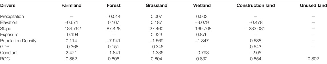
TABLE 4. Results from the Logistic regression analysis of Sanmen Bay.
Table 4 shows that in Sanmen Bay, the layout of farmland is predominantly driven by elevation, slope, exposure, and population density, the layout of the forest by slope and exposure, the layout of grassland by slope and population density, and the layout of wetland by elevation, slope, and population density. The layout of land used for construction is negatively correlated with slope. Eventually, the ROC test values of all the landscape genres reached 0.8, a testament to the credibility of the Logistic regression model in the case of analysis on drivers regarding Sanmen Bay.
To achieve overall optimization of land and sea resources, coordination efforts must be made between coasts and hinterlands, between sea islands and coastal zones, and between bays and the ocean.
First, the industrial landscape of ZGBA’s coastal areas has taken on a new look. Specifically, traditional labor-intensive industries cause great energy consumption and severe pollution or require large development space to be relocated to more land-locked areas for a longer industrial chain. At the same time, holding polluters and developers accountable helps grow the economy of relocated areas, and by relocating industries, the ecological carrying capacity of bays is enhanced, and the shortage of space in coastal regions eased. Second, amid advancing new urbanization, the development of featured and beautiful administrative villages and towns in coastal areas encourages the appropriate use of space along the coast and the planning and utilization of sea islands, including uninhabited islands and reefs. That means the synchronized development of sea island-based industries by leveraging local or nearby resources, human resources, and administrative division makes space utilization in sea islands and coastal zones more efficient and ensures accountability in conserving the marine environment. Third, coordination between bays and the ocean is essential for the utilization of ZGBA’s spatial resources. Buildings featured free trade areas and duty-free zones necessitate reasonable shipping routes, strong ocean transport capabilities, and efficient transportation systems in port areas. Likewise, to foster sea farming, modern fishing ports are a must. Bays and the ocean need to grow hand-in-hand as they have a shared stake.
The principle of developing land resources based on the ocean must be followed through, meaning the ocean needs to control how lands are used and protected.
The socio-economic activities of humans and the progress of civilization have centered on land for a long time. As the largest waterbody on the Earth, the ocean is often regarded as an area to expand land resources. The deep-rooted idea has put the planning and development of lands above those of the ocean. However, the once-popular stereotype has its own limitations, and therefore, the ocean should never become a desperate resort to a larger landmass or a bag for garbage from lands. Given that, the carrying and self-purification capacities of the ocean should be taken into account when it comes to waste dumping, and resources can never be tapped through land reclamation. That means the ocean and land should be treated equally, and their spatial development should also be subject to the conservation of the sea, bays, and coastal areas.
In Sanmen Bay, the declining shoreline and wetland shrinkage contribute to the lower capacity of seawater for self-purification, rampant eutrophication, and worsening biological diversity, posing a grave hazard to its ecosystem. The concentration of inorganic nitrogen and reactive phosphate in Sanmen Bay can meet the quality standard for the second-class seawater if the focus is on the heavily polluted areas and other ecological function areas that have a greater capacity for pollutant load. The blue bay ecological governance plan needs to be carried out with the launch of coastline ecological restoration and rigorous regulation on and control over reclamation conducts in Sanmen Bay. Meantime, under the vision of improving its ecological environment, the comprehensive values of islands in the Bay should be raised, and efforts should be made to build the Bay into an ecologically economic pilot zone that meets the targets set in the development of a maritime ecological civilization.
According to analysis on the capacity of terrestrial catchments for pollutant load, as the capacity for pollutant load drops expressly, it is necessary to adopt stringent measures of regulation and control across the entire process of waste discharge by factories along the coast, such as cutting the incidents of incomplete combustion of sulfide and lowering the frequency of acid rain in terrestrial catchments. It is advisable to vigorously promote sophisticated mariculture technology, control the density and intensity of mariculture and carry out science-based planning for the makeup and layout of mariculture. Besides, we should make good use of the environmental capacity of the interior part of the Bay and harness fodders and drugs in proper manners to lessen the severity of eutrophication and hazards of red tide. With more frequent exchange between the water and the rest of the environment, the water is better placed to spread pollution, facilitating the movement and transmission of pollutants. Meanwhile, regulation and control over the coastline port shipyards should be stepped up. For instance, the toxic substances, including toxic gas emitted by volatile organic compounds, arising in the course of ship paint brushing should be recycled collectively to alleviate the hazards posed by secondary pollution. On top of that, following the discrepancy in self-purification capacity between different water zones, those areas hit mildly by pollution are first selected as the recipients of sewage discharged by the factories, if conditions permit. The accomplishment of long-term emission reduction targets entails more sources of pollution put under control at their onset, compounded by reasonable planning for industrial layout and the implementation of a system for control over aggregated emission. Besides, efforts should be redoubled to develop the renewable energy industry along the coast, ranging from nuclear power generation represented by the Sanmen nuclear power plant, hydroelectricity represented by the Sheshan pumped-storage hydroelectric station, to wind and tidal power generation, with a view to building Sanmen Bay into a pilot zone for clean energy.
Sanmen Bay is geographically in a critical position to connect itself with the neighboring regions. However, diverse ecological issues have arisen from excessive development. In this connection, the contradiction between the severe resource shortage and mankind’s insatiable demands should not be flouted, new ways to development should be explored, and the ecological conservation of Sanmen Bay be stepped up. For instance, reducing the discharge of living and industrial sewage into the sea not only upgrades the capacity of Sanmen Bay’s terrestrial catchments for pollutant load, but eases pressure on the marine ecosystem. Hence, it is imperative to proactively ramp up concentrated treatment of sewage and improve sewage treatment techniques, such as the processing of living sewage in cities in a concentrated manner and subsequent discharge on condition that it meets the quality standard for surface water and second-class seawater. This is how we can preserve the surface water resources of terrestrial catchments and the quality and environment of seawater. Cutting emission from the source of pollution necessitates detoxification treatment of pollution produced by husbandry. A case in point is dehydrating and lightening the dung via composting, and it is also feasible to recycle the dung to fertilize the field or transform it into renewable energy via secondary treatment in biodigesters. Actions should be taken to vigorously promote a new model of highly efficient fertilizers, raise the utility of fertilizers and fertility of soil while reducing the volume of fertilizers in use, and ease the pressure imposed by traditional cultivation modes on the ecological environment. It is advisable to make reasonable use of the marine resources of Sanmen Bay to ensure coordination among ecological conservation, industrial advancement, and well-off life.
Large-scale reclamation activities around Sanmen Bay shorten its natural shoreline, cut its capacity for tidal prism, and weaken the waters’ capacity for exchange. On this note, reclamation activities should be put under strict control and improved through technology, policy, and management. Therefore, various positive measures should be taken holistically to sustain the improvement of Sanmen Bay’s ecosystem, and investment in infrastructure should be scaled up. A reasonable order governing the development of marine resources and the mechanism for cross-regional coordination and management should be set up via exploration, and such basic functions of the Bay as harbor, industrial hub, and seaboard tourism destination should persist.
Geographically well-positioned, Sanmen Bay should fully leverage its strength with the launch of integrated governance on the coast. With importance attached to ecological development, ecological progress should be made along with socio-economic development. In pursuit of harmonious co-existence between men and nature, typical practices involve orderly advancing the pilot project of wetland restoration, making full use of coastlines of ecological value and wetland landscape, expediting the development of national-level wetland ecotourism, and phasing in restoring the lost ecosystem services across various oceanic areas.
On such issues as marine overfishing and the decrease of marine biological resources in Sanmen Bay, great efforts should be made to develop ecological fishing without compromise, and the traditional ways to development should be altered. For instance, it is sensible to roll out the fish stocking and set up marine pasture. Beyond that, action should be taken to step up pollution governance in aquaculture and preserve oceanic ecological environment aquatic biological resources to develop modern fishing into an industry with reasonable layout, advanced science and technology, and distinctive regional characteristics. It is advisable to make full use of the abundant natural and cultural landscape and ecological and coastal resources of Sanmen Bay, and take further steps to draw up ecotourism planning to build the Bay into a regionally distinctive ecotourism destination.
Based on the overall realities of Sanmen Bay’s coupled society-economy-ecology system and the demands for maritime ecological development, professional staff training should be carried out, and environmental monitoring stations laid out to elevate the capabilities of surveying and monitoring the environment. Meaningful practices involve the real-time monitoring of major projects that use oceanic areas, the establishment of long-term red tide monitoring and prediction system, the formulation of marine disaster contingency plan and measures, the stepped-up research on the restoration of polluted waters in mariculture zones, the integrated planning and governance of pollution outfalls, and the improvement of the environment of marine life.
The master and special plans for development and utilization in local areas should be improved based on the ecological environment and social development of Sanmen Bay and in alignment with the urban planning of the counties of Sanmen, Ninghai, and Xiangshan. In addition, a multilevel all-dimensional system for developing and protecting Sanmen Bay should be established to upgrade the utility of its marine resources and improve its ecological environment. In the meantime, an effective mechanism for regional coordination and compensation, coupled with a comprehensive system for managing the ecological environment, should be built to make clear the division and cooperation of environmental regulators, further propel the comprehensive administration of the Bay, and ensure its sustainability.
The original contributions presented in the study are included in the article/Supplementary Material, further inquiries can be directed to the corresponding author.
LL conceived the conceptualization, acquired the funding and administrated the project; XZ conducted the investigation, analyzed data and refined the methodology; LL and XZ wrote the original draft; ZC, HZ, and CL reviewed and YC editing the final paper.
The paper is co-funded by the 2021 Soft Science Research Project of Zhejiang Province titled “Research on evaluating green development of typical bays in Zhejiang from the perspective of ecological progress—A case study of Sanmen Bay” (2021C35083), 2020 Basic Scientific Research Project of Zhejiang Tongji Vocational College of Science and Technology titled “Research on the evaluation system and construction path of “Blue Bay” from the perspective of ecological civilization” (FRF20PY001) and the 2020 Basic Scientific Research Project of Provincial Universities in Zhejiang titled “Research on ideological progress on water culture integration from the perspective of ecological progress” (2021XZ009).
The authors declare that the research was conducted in the absence of any commercial or financial relationships that could be construed as a potential conflict of interest.
All claims expressed in this article are solely those of the authors and do not necessarily represent those of their affiliated organizations, or those of the publisher, the editors and the reviewers. Any product that may be evaluated in this article, or claim that may be made by its manufacturer, is not guaranteed or endorsed by the publisher.
Thanks to Tourism and Exhibition Department affiliated with School of Economics and Social Welfare that aided the efforts of the authors.
Hou, X., Hou, W., and Wu, T. (2016). Shape Changes of Major Gulfs along the Mainland of China since the Early 1940S[J]. Acta Geogr. Sin. 71 (1), 118–129.
Jiao, N. (2001). Ecological Processes and Sustainable Development of Typical Coastal Water Ecosystems in China. Beijing: Science Press.
Jones, P., and Wynn, M. G. (2021). The Circular Economy, Resilience, and Digital Technology Deployment in the Mining and Mineral Industry. Int. J. Circular Econ. Waste Manag. (IJCEWM) 1 (1), 16–32. doi:10.4018/ijcewm.2021010102
Khan, S. A. R., Ponce, P., Thomas, G., Yu, Z., Al-Ahmadi, M. S., and Tanveer, M. (2021a). Digital Technologies, Circular Economy Practices and Environmental Policies in the Era of COVID-19. Sustainability 13 (22), 12790. doi:10.3390/su132212790
Khan, S. A. R., Zhang, Y., and Sharif, A. (2021b). No Silver Bullet for De-carbonization: Preparing for Tomorrow, Today. Resour. Policy 71, 101942. doi:10.1016/j.resourpol.2020.101942
Liu, C., Liu, G., Yang, Q., Luo, T., He, P., Franzese, P. P., et al. (2021). Emergy-based Evaluation of World Coastal Ecosystem Services. Water Res. 204, 117656. doi:10.1016/j.watres.2021.117656
Lu, C. (2013). SWOT Analysis and Strategic Choices for Accelerating the Regional Development in Sanmen Bay[J]. Mar. Econ. 3 (01), 49–53. doi:10.19426/j.cnki.cn12-1424/p.2013.01.009
Seetharaman, A., Shah, M., and Patwa, N. (2022). A Transition to a Circular Economic Environment. Int. J. Circular Econ. Waste Manag. (IJCEWM) 2 (1), 1–13. doi:10.4018/ijcewm.288500
Song, Z., Shi, W., Zhang, F., Wu, Q., Yang, B., Zhou, Y., et al. (2017). Field Observation and Analysis on the Characteristics of Tidal Dynamics in Sanmen Bay[J]. J. Appl. Oceanogr. 36 (2), 279–285. doi:10.3969/J.ISSN.2095-4972.2017.02.0159
Su, H., Hou, X., and Di, X. (2016). Spatio-temporal Characteristics and Scenario Analysis of Land-Use Change in the Beibu Gulf Economic Rim Coastal Area, China[J]. Mar. Sci. 40 (09), 107–116. doi:10.11759/hykx20150708001
Wang, S., Tao, Z., Sun, P., Chen, S., Sun, H., and Nan, L. (2022b). Spatiotemporal Variation of Forest Land and its Driving Factors in the Agropastoral Ecotone of Northern China[J]. J. Arid Land 14 (01), 1–13. doi:10.1007/s40333-022-0001-4
Wang, W., Lin, C., Jiang, R., Liu, Y., Sun, X., Lin, H., et al. (2022a). Distribution, Source Identification and Environmental Risk Assessment of Potentially Toxic Elements (PTEs) in the Surface Sediment of Sanmen Bay, Zhejiang Province, China. Mar. Pollut. Bull. 174, 113237. doi:10.1016/j.marpolbul.2021.113237
Xia, X., and Xie, Q. (1996). Coastal Evolution and Comprehensive Development of Sanmenwan Bay, Zhejiang Province[J]. Mar. Sci. Bull. 15 (4), 49–56.
Xu, Y., Gao, H., Xiao, W., and Zhu, J. (2021). The Effects of Reclamation Activity and Yellow River Runoff on Coastline and Area of the Laizhou Bay, China[J]. J. Ocean Univ. China 20 (03), 729–739. doi:10.1007/s11802-021-4746-8
Yang, R. J., Liu, J. T., Su, C. C., Chang, Y., Xu, J. J., and Kit, L. H. (2021). Land-Ocean Interaction Affected by the Monsoon Regime Change in Western Taiwan Strait [J]. Front. Mar. Sci. 8. doi:10.3389/fmars.2021.735242
Yang, S., and Chen, P. (2018). Characteristics of Natural Environment and Sustainable Utilization of Resources in Sanmen Bay. Qingdao: China Ocean University Press.
Yao, Y., and Huang, X. (2015). Research on Marine Environment Capacity and Total Pollutant Load Control in Sanmen Bay. Beijing: Maritime Press.
Yu, Z., Khan, S. A. R., and Umar, M. (2022). Circular Economy Practices and Industry 4.0 Technologies: A Strategic Move of Automobile Industry. Bus. Strat. Env. 31 (3), 796–809. doi:10.1002/bse.2918
Zhang, H., Xia, X., Pan, J., et al. (2013). Realities of Marine Environment and Resources in Zhejiang Province. Beijing: Maritime Press.
Zhou, Y., Dou, Y., Yu, X., Zhang, L., Huang, C., Wang, Y., et al. (2020). Examining Health of Wetlands with Multiple Ecosystem Services as Targets in China's Coastal Regions[J]. Chin. Geogr. Sci. 30 (04), 600–613. doi:10.1007/s11769-020-1137-9
Keywords: ecological progress, sustainability, bay, common prosperity, Sanmen Bay
Citation: Liu L, Zhang X, Chen Z, Zhou H, Li C and Chen Y (2022) Assessment of Ecological Sustainability for International Bays in the Context of Common Prosperity—A Case Study of Sanmen Bay in Zhejiang Province. Front. Environ. Sci. 10:944936. doi: 10.3389/fenvs.2022.944936
Received: 16 May 2022; Accepted: 26 May 2022;
Published: 08 June 2022.
Edited by:
Syed Abdul Rehman Khan, Xuzhou University of Technology, ChinaReviewed by:
Laeeq Razzak Janjua, Vistula University, PolandCopyright © 2022 Liu, Zhang, Chen, Zhou, Li and Chen. This is an open-access article distributed under the terms of the Creative Commons Attribution License (CC BY). The use, distribution or reproduction in other forums is permitted, provided the original author(s) and the copyright owner(s) are credited and that the original publication in this journal is cited, in accordance with accepted academic practice. No use, distribution or reproduction is permitted which does not comply with these terms.
*Correspondence: Xiujuan Zhang, emhhbmd4aXVqdWFuX3p4akBvdXRsb29rLmNvbQ==, emhhbmd4aXVqdWFuQHpqdS5lZHUuY24=
†These authors have contributed equally to this work and share first authorship
Disclaimer: All claims expressed in this article are solely those of the authors and do not necessarily represent those of their affiliated organizations, or those of the publisher, the editors and the reviewers. Any product that may be evaluated in this article or claim that may be made by its manufacturer is not guaranteed or endorsed by the publisher.
Research integrity at Frontiers
Learn more about the work of our research integrity team to safeguard the quality of each article we publish.