 Yuanlai Wu1
 Houtian Tang
 Ping Jiang
94% of researchers rate our articles as excellent or good
Learn more about the work of our research integrity team to safeguard the quality of each article we publish.
Find out more
ORIGINAL RESEARCH article
Front. Environ. Sci., 24 June 2022
Sec. Land Use Dynamics
Volume 10 - 2022 | https://doi.org/10.3389/fenvs.2022.909554
This article is part of the Research TopicTowards Sustainable Urban Development: Use of Geographic Big Data for Spatial PlanningView all 25 articles
The rural residential land (RRL) in natural reserves has been deeply transformed due to the disturbance constrained by ecological protection policies. Exploring the distribution characteristics and driving factors of RRL in natural reserves and non-natural reserves will help to promote the governance of land space and alleviate the contradiction of land use. Therefore, taking 122 county-level administrative regions in Hunan Province as an example, this article analyzes and compares the spatiotemporal distribution characteristics of RRL in natural reserves and non-natural reserves by using land use change dynamics, nuclear density analysis, the transfer matrix model, and the ordinary least-squares model and explores how the establishment of natural reserves affects the RRL area change. The results show that (1) the overall RRL area in Hunan changed from 171,162.27 hm2 in 2000 to 169,914.6 hm2 in 2020, with a total reduction of 1,247.67 hm2 and a decrease of 0.73%, and the distribution of the RRL area change presented a hot trend in the northeast and a cold trend in the southwest. (2) The occupation of urban construction land is the main reason for the reduction in RRL area, and the transformation of cultivated land and forestland into RRL is the main source of the increase in RRL area. (3) During 2000–2020, the overall RRL in natural reserves increased by 1,538.37 hm2, with an increase of 0.11%, while the overall RRL in non-natural reserves decreased by 2,786.04 hm2, with a decrease of 0.14%. (4) The establishment of natural reserves has a significant negative correlation with the area of RRL in 2000, 2010, and 2020, indicating that the establishment of natural reserves can limit the growth speed of the RRL area to a certain extent, but is affected by factors such as economic development and rural population growth; it cannot directly promote the overall reduction of RRL area. The results of this study can provide a reference for decision-making related to the spatial structure optimization of natural reserves and non-natural protected RRL and the coordinated development of urban and rural areas.
The contrast between urban expansion and rural recession is becoming increasingly serious (Long et al., 2012; Bai et al., 2014; Liu and Li, 2017; Li K. et al., 2021). As a very important land use type in rural areas, rural residential land (RRL) is an important carrier of farmers’ production and life (Chen et al., 2019; Yang R. et al., 2019). Since its emergence in the specific natural and cultural environment, it has been affected by the natural increase and decrease in the rural population and the slow growth of the rural economy (Qu et al., 2017). However, with the rapid development of rural economies around the world, the functions and layout of rural settlements have changed significantly and are evolving toward heterogeneity and non-simplification (Zhu et al., 2014; Li G. et al., 2020; Rosner and Wesołowska, 2020). Meanwhile, due to the interaction of historical origin, customs, resource endowment, transportation convenience, and other factors, the spatial layout of RRL is mostly formed by the independent selection and lack of unified planning (Shcherbina and Gorbenkova, 2019; Wang and Zhang, 2021). This continuous disorderly expansion also exacerbates the fragmentation of RRL (Li G. et al., 2020). During the early stages, developed countries such as South Korea and Germany were the first to realize the importance of spatial planning of rural settlements and conducted the consolidation movement of RRL, including the “New Village Movement” in South Korea (Suh, 2015) and the “Village Renewal” in Germany (Zasada and Piorr, 2015). Moreover, with the gradual prominence of the contradiction between man and land, developing countries such as China, Uzbekistan, and Myanmar have paid more attention to the spatial planning of RRL and have issued corresponding policies (Conrad et al., 2015; Hoffman-Hall et al., 2019; Zhou et al., 2021). However, unlike developed countries, developing countries have some disadvantages in experience, technology, and capital, which makes it difficult to realize the consolidation of RRL (Njoh, 2011; Trukhachev, 2015; Rosner and Wesołowska, 2020). Therefore, promoting RRL consolidation has always been a thorny problem faced by China and other countries lacking land resources, and it is of great significance to make the rational use of RRL and alleviate the contradiction between land supply and demand (Li et al., 2014; Kong et al., 2021).
In consideration of social and economic development, China’s urban construction and development are relatively rapid, and relevant guidance planning and supporting infrastructure construction are also relatively abundant (Fernández, 2007; Guan et al., 2018; Li Y. et al., 2020). However, the construction and development of RRL lack planning guidance, which leads to the increasingly prominent phenomena of scattered layout, high degree of fragmentation, low utilization efficiency and serious illegal land occupation of RRL (You and Chen, 2019; Wen et al., 2020; Li J. et al., 2021). Moreover, it has further derived problems such as the extensive use of RRL, the lack of living infrastructure, and the fragile ecological environment, which have led to the continuous decline of rural development potential (Wu et al., 2017; Li Y. et al., 2018; Ristić et al., 2019). Nevertheless, with the improvement of rural residents’ income level, lifestyle transformation, and rural cultural progress, rural residents have also put forward new requirements for production, living conditions, and environment quality (Zhou et al., 2020; Deng et al., 2021). Using the Hunan Province of China as an example, statistical yearbooks of the Hunan Provincial Bureau of Statistics, the urbanization rate increased from 29.75% in 2000 to 58.76% in 2020, with extremely rapid growth. In the context of rapid urbanization, the nonagricultural rural population has led to a significant reduction in the rural resident population; a large amount of rural construction land has been gradually abandoned and left idle, and the abandonment of houses in villages has become very serious, which further intensifies the sharp contradiction between the current tight supply of urban construction land and the idle waste of land resources in rural settlements (Li L. et al., 2020; Huang et al., 2020; Zhu et al., 2020).
Previous studies have conducted rich theoretical research and practical explorations of RRL (Linard et al., 2012; Phokaides, 2018; Li S. et al., 2021; Nandi and Mistri, 2022). Scholars generally believe that the spatial distribution and evolution of rural settlements are the result of the comprehensive action of physical and geographical conditions and socioeconomic development (Yu et al., 2018; Li G. et al., 2020). The scale, shape, distribution, and other characteristics of rural settlements are closely related to natural conditions such as landform, soil, hydrology, climate, and vegetation and are affected by factors such as government regulation, economic development, urbanization level, traffic conditions, and scientific and technological strength (Linard et al., 2012; Liu et al., 2016; Tu et al., 2018; Cyriac and Firoz, 2022). Meanwhile, in a short period of time, RRL changes are more affected by human factors (Wang and Zhang, 2021). Specifically, in the existing studies, the research contents of rural settlements are relatively diversified, mainly focusing on the characteristics of spatiotemporal evolution and its driving factors, spatial layout optimization, functions, etc., gradually enriching the content system of rural settlement research (Heng et al., 2021; Tan et al., 2021). Moreover, the research on RRL also presents different research scales, including mainly analyses of the overall evolution and driving mechanism of RRL at the macroscale, explorations of the structure, function, and spatial layout optimization of RRL, and the gradual transformation from the national and provincial macroscale to the shrinking of the county, town, and even village at the microscale (Li G. et al., 2018; Chirisa, 2021). In addition, the research methods on rural settlements are diverse, mainly involving multifactor comprehensive evaluation methods, spatial econometric analysis, spatial autocorrelation, geographic information systems, geographic detectors, and other methods and models, revealing the general or local characteristics of the research content of rural settlements (Yang et al., 2019a; Gosch et al., 2021; Kong et al., 2021).
However, only a few scholars have conducted research on RRL in the natural reserve. Among them, Yao and Xie (2016) believed that the scale of RRL in the natural reserve should be the smallest, while the scale of ecological land should be the largest. Abelairas-Etxebarria and Astorkiza (2012) compared the difference in land prices within and outside the natural reserve and found that the policy of establishing a natural reserve has a highly restrictive effect on land transaction volume and land use change. Martín and Chehébar (2001) researched indigenous communities and RRL inhabited by migrant populations in the federal protected area system of Argentinian Patagonia and found that the growth of RRL directly threatened the ecological environment. Previous studies have neglected to explore and compare the spatiotemporal variation characteristics of RRL in natural reserves and non-natural reserves. As an area designated by relevant government departments to protect special ecosystems for scientific research, natural reserves have played an important role in soil and water conservation, environmental improvement, biodiversity protection, and ecological balance (Zhou and Chen, 2006; Yang et al., 2019b). In the natural reserve, to protect the ecological environment, the government has issued a variety of policies and measures to encourage the relocation of residents in the ecological reserve or limit the new expansion of existing rural settlements, which makes the rural settlements in the natural reserve form a completely different spatiotemporal evolution characteristic (Yu et al., 2018). Therefore, comparing the spatiotemporal evolution characteristics of RRL in the natural reserves and non-natural reserves can not only enrich the research topics related to RRL in the natural reserve but also provide policy suggestions for the management organization of the natural reserve to optimize and reduce the land use of RRL.
Therefore, we explore the differences in the spatiotemporal evolution characteristics, change intensity, and driving factors of RRL between natural reserves and non-natural reserves. Based on the relevant spatial and panel data of rural settlements in natural reserves and non-natural reserves of Hunan Province, China, and combined with the methods of land use dynamics, kernel density analysis, transfer matrix model, and ordinary least-squares model, this article intends to solve the following issues. (1) What are the overall spatiotemporal change characteristics of RRL in Hunan Province? (2) What are the spatiotemporal evolution characteristics of RRL in natural reserves and non-natural reserves? What is the difference? (3) What is the impact of the establishment of natural reserves on the spatiotemporal changes in RRL? Moreover, we believe that the results of this study can provide a decision-making reference for the spatial structure optimization of natural reserves and non-natural protected RRL and the coordinated development of urban and rural areas.
China’s Hunan Province governs 14 prefecture-level cities (including autonomous prefectures), with a total of 122 county-level administrative regions (including county-level cities, districts, and autonomous counties, uniformly called counties), and is located in the middle reaches of the Yangtze River (Figure 1). Superior natural conditions have created the characteristics of rich animals and plant biodiversity and a beautiful natural landscape in Hunan Province (Ding et al., 2022; Fan et al., 2022). Provincial or national natural reserves in Hunan Province were distributed in 27, 42, and 44 counties in 2000, 2010, and 2020, respectively. By 2021, the permanent resident population of Hunan Province was 66.44 million, and the regional gross domestic product was 4,606.3 billion RMB. With the rapid development of the social economy, the disposable income of farmers has been significantly improved, and its urbanization rate has increased from 29.75% in 2000 to 58.76% in 2020. However, due to the geographical conditions, the industrial structure and economic development of various regions in Hunan Province are quite different, resulting in the structure and functional space of RRL being significantly differentiated, which is mainly reflected in the scattered layout of RRL, a high degree of fragmentation, and obvious differences in hollowing (Tang et al., 2018; Han et al., 2021), especially in natural reserves and non-natural reserves. Therefore, this article selects Hunan Province with the characteristics of typical natural reserves and non-natural reserves as the research area, which has strong practical significance for the multifunctional promotion and coordinated optimization of RRL.
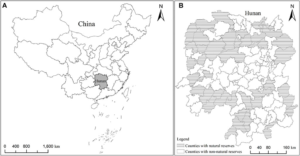
FIGURE 1. Study area. [Panel (A): geographical location of the Hunan Province in China. Panel (B): geographical location of counties with natural reserves and non-natural reserves in Hunan Province in 2020].
The land use data and the provincial, municipal, and county-level administrative division boundary data of Hunan in this article are from the Resource and Environmental Science and Data Center of the Institute of Geographical Sciences and Resources, Chinese Academy of Sciences (https://www.resdc.cn/). Among them, the land use data cover the three periods of 2000, 2010, and 2020, with a 30 m resolution. Using the reclassify function of ArcGIS10.5 software, the land types were reclassified into eight categories: cultivated land, forestland, grassland, water area, urban construction land, RRL, other construction land, and unused land; the area data of each land type were obtained. In addition, the rural population, economic, and social data involved in the study are mainly from the statistical yearbooks of the Hunan Provincial Bureau of Statistics (http://tjj.hunan.gov.cn/). On this basis, ArcGIS10.5 software is used to form the basic database for the study of RRL area change in Hunan Province through the spatial matching and link between attribute data and county-level administrative units, which lays the data foundation for this study.
The dynamic degree model of land use change is the quantitative change of a certain land use type in the study area during the study period (Stumpf et al., 2018). Through the dynamic degree of land use change, the area and change speed of various land types in the region at different time points can be obtained, the general change trend and structural evolution trend in different research periods can be grasped, and the core of the model is reflected by land use transfer flow (Gallant et al., 2004; Öztürk et al., 2013). This article uses this model to analyze the spatiotemporal changes in RRL in Hunan Province. The calculation formula is as follows:
where K represents the dynamic degree of RRL change in the study period;
The transfer matrix model can effectively describe the structural characteristics and transformation direction of land use change in the study area and can also analyze the change characteristics of the spatial conflict level of various land types during different periods (Romero-Calcerrada and Perry, 2004; Xue et al., 2018). This article uses this model to analyze the direction and quantity of mutual transformation between RRL and other land use types in Hunan Province. The calculation formula is as follows:
where n represents the number of land use types; i and j represent the land use types at the beginning and end of the study periods, respectively; and Tij represents the area converted from land use type i to land use type j during the study period.
Kernel density estimation is a nonparametric calculation method that usually uses the built-in spatial analysis tool of ArcGIS10.5 software to define the nearest-neighbor object and realize the measurement of density distribution (Elgammal et al., 2002). At present, the kernel density estimation method has been applied to the study of spatial distribution patterns and change characteristics of various land use types (Gong et al., 2019). The higher the value of kernel density is, the greater the distribution density of RRL (Lin et al., 2022). This method mainly analyzes the spatiotemporal distribution pattern and change characteristics of RRL in natural reserves and non-natural reserves in Hunan Province. The calculation formula is as follows:
where
Getis-Ord Gi* hot-spot analysis is used to measure the spatial clustering intensity between each unit in the study area and its surrounding units. It mainly detects whether each geographical element belongs to a high-value or low-value aggregation mode in space by calculating the relationship between the geographical attributes of a location and the geographical attributes of its adjacent locations (Gao et al., 2019; Tan and Guan, 2021). This article uses this method to explore the degree of change and difference in RRL between natural reserves and non-natural reserves in Hunan Province. The calculation formula is as follows:
where Gi* represents the statistical value of Getis-Ord;
The ordinary least-squares method is used to evaluate the relationship between two or more element attributes. The principle of this method is to minimize the sum of squares of errors between the predicted value and the actual observed value of the regression empirical model (Sanchez, 2020; Liang and Qamruzzaman, 2022). This method is mainly used to explore the factors affecting the change in RRL. This article uses the change in the RRL area as the dependent variable and determines the model with better fitting through the forward stepwise regression method. The MNL-1 model only adds the influencing factors of the RRL area change, while the MNL-2 model adds the interactive term based on the MNL-1 model. The calculation formula is as follows:
The global parameter estimation vector can be obtained by using the ordinary least-squares model
where
The area change in RRL is closely related to natural, socioeconomic, land management, and other factors (Liu et al., 2013; Li G. et al., 2018, Li et al., 2020 G.). Based on the actual situation of Hunan Province and the availability of data, referring to previous research results (Zhou et al., 2013; Ristić et al., 2019; Wang and Zhang, 2021), and following the principles of scientificity and comprehensiveness, this article takes the area of RRL as a dependent variable. Meanwhile, four dimensions, including natural reserves, urban expansion, economic growth, and rural development situation, were selected, including 11 dependent variable indicators as the influencing factors of the change in the RRL area (Table 1).
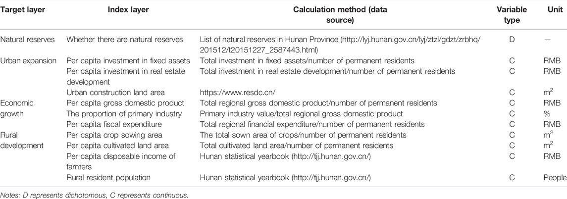
TABLE 1. Factors influencing RRL.
First, due to the high intensity of environmental regulation policies within the scope of natural reserves (Zhou et al., 2014), the delimitation of natural reserves may have a significant impact on the change in RRL areas. The indicator of whether there are natural reserves set in this article only explores whether the county-level administrative units have provincial or national nature reserves.
Second, there is a certain contradiction between urban expansion and RRL because the rapid expansion of urban areas will accelerate the urbanization process of rural populations and may reduce the demand area of RRL (Liu et al., 2017; Yang et al., 2018). Therefore, the urban expansion dimension in this article includes three indicators: per capita investment in fixed assets, per capita investment in real estate development, and the urban construction land area. Among them, the per capita investment in fixed assets represents the local construction investment level, the per capita investment in real estate development represents the local investment level in urban housing construction, and the urban construction land area represents the actual situation of local urban expansion.
Third, rapid economic growth can increase the per capita gross domestic product, increase government fiscal expenditure, adjust the structure of local industries, promote the improvement of the speed of rural economic development, and affect the number of people engaged in agricultural production, resulting in affecting the change rate in the RRL area (Ma et al., 2018; Qu et al., 2021). Therefore, the economic growth dimension of this article also includes three indicators: per capita gross domestic product, the proportion of primary industry, and per capita fiscal expenditure. Among them, the per capita gross domestic product represents the economic development of the research county, the proportion of the primary industry represents the importance of the primary industry in the local industrial structure, and the per capita fiscal expenditure represents the fiscal expenditure capacity of the local government.
Finally, there is a strong correlation between rural development and the change in the RRL area. Generally, areas with better rural development have greater population mobility, and farmers are more likely to change their place of residence due to work, transportation, and other factors (Sun et al., 2021). The dimensions of rural development in this article mainly include four indicators: per capita crop sowing area, per capita cultivated land area, per capita disposable income of farmers, and rural resident population. Among them, the per capita sown area of crops represents the agricultural planting status of the local rural surplus labor force, the per capita cultivated land area represents the cultivated land resources owned by local farmers to carry out basic agricultural production, the per capita disposable income of farmers represents the development degree of the local rural economy, and the rural resident population represents the number of people living in rural areas for a long time.
Based on the area change transfer matrix between RRL and other land types from 2000 to 2020 (Supplementary Appendix) and the spatiotemporal change distribution characteristic of RRL (Figure 2), the RRL area decreased from 171,162.27 hm2 in 2000 to 169,914.60 hm2 in 2020, with a total reduction of 1,247.67 hm2 and a decrease of 0.73%. The reason can be found that in 2000–2020, although RRL occupied the largest area of cultivated land, the net occupied area of cultivated land was as high as 5,773.32 hm2. However, due to a large number of RRLs occupied by urban and other construction lands, the RRL showed a downward trend from 2000 to 2020. This phenomenon can also be confirmed in Figure 2. The red spots (representing the gain of RRL) are significantly greater than the green spots (representing the loss of RRL). Specifically, the RRL area decreased by 5,165.10 hm2 in 2000–2010; that is, the RRL area transferred out at this stage was greater than the area transferred in, while the RRL area increased by 3,917.43 hm2 in 2010–2020. The main reason is that the urban expansion was relatively rapid, requiring higher amounts of urban construction land, resulting in a large amount of RRL occupied by urban construction land in 2000–2010. Moreover, due to the vigorous implementation of policies such as converting farmland to forestland during that time, some areas that reclaimed RRL were transferred to forestland. In 2010–2020, due to the stricter control over the expansion of urban construction land, the occupation of urban construction land to RRL was effectively alleviated. However, due to the reduction in the RRL area in 2000–2010 and the strong demand of farmers for RRL, a large amount of cultivated land and forestland around RRL was occupied. In addition, the distribution of RRL is too scattered, which is not obvious in Figure 2, but the overall density is high in the northeast and low in the southwest. The reason for this scattered layout may be that northeastern Hunan is a traditional agricultural area with high residential density.
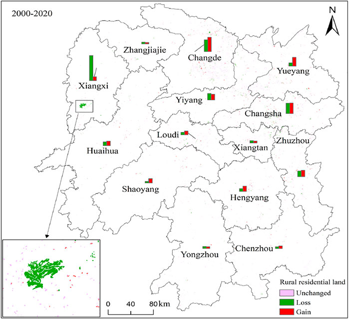
FIGURE 2. Distribution of RRL change in 2000–2020.
By analyzing the changes in the RRL area in 14 prefecture-level cities in Hunan Province from 2000 to 2020 (Table 2), it can be found that the RRL area in different prefecture-level cities shows different changes, and the changes in RRL in the same prefecture-level city at different stages also show significant differences. It is worth noting that in 2000–2010 and 2010–2020, excluding the dynamic change degree of the RRL area in Xiangxi, which has been in a negative growth state, other prefecture-level cities showed an initial decreasing and then increasing or continuously increasing trend. Specifically, the reduction rate of the residential land area in Xiangxi in 2000–2020 is much higher than that in other prefecture-level cities, and the dynamic degree of the change of the RRL area in this prefecture in 2000–2010 indicates that the comprehensive improvement intensity of RRL in Xiangxi during 2000–2010 is high, which causes the area of RRL in this stage to show a significant trend of reduction. In addition, among the other 13 prefecture-level cities, the overall change dynamics of RRL in Xiangtan, Zhangjiajie, Yiyang, and Yongzhou showed negative growth in 2000–2020, indicating that the area of RRL in these cities decreased. In contrast, the dynamic change degree of the RRL area in Changsha, Zhuzhou, Hengyang, Shaoyang, Yueyang, Changde, Chenzhou, Huaihua, and Loudi positively increased and showed a small growth trend in 2000–2020.
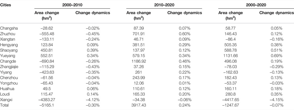
TABLE 2. RRL change in prefecture-level cities from 2000 to 2020.
The cold-spot and hot-spot analyses of RRL identify the spatial cluster distribution of high- and low-function values based on the spatial distribution of each function value domain. The hot-spot analysis tool in ArcGis10.5 software is used to identify the statistically significant distribution characteristics of cold and hot spots in the current situation and changes in the RRL area in 122 counties of Hunan Province. Among them, the value of
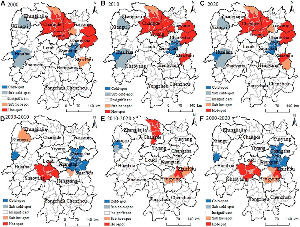
FIGURE 3. Cold-spot and hot-spot distributions of the RRL area and change dynamics at the county level in Hunan Province from 2000 to 2020. [Panels (A–C) show the distribution of cold spots and hot spots in the current area of RRL in various counties of Hunan Province in 2000, 2010, and 2020, respectively. Panels (D–F) show the distribution of the change dynamics of RRL in various counties of Hunan Province in 2000–2010, 2010–2020, and 2000–2020, respectively.]
Table 3 shows that from 2000 to 2020, the RRL area in natural reserves and non-natural reserves decreased in 2000–2010 but increased in 2010–2020. It is worth noting that the overall area of RRL in natural reserves increased by 1,538.37 hm2 in 2000–2020, with an increase of 0.11%, while the overall area of RRL in non-natural reserves decreased by 2,786.04 hm2 in 2000–2020, with a decrease of 0.14%. According to the dynamic degree of change in the RRL area of counties in natural reserves and non-natural reserves in 2000–2010, 2010–2020, and 2000–2020, it was divided into five intervals by using the natural break method in ArcGIS 10.5 software (Figures 4A–C). Meanwhile, to intuitively express the change characteristics of the RRL area in counties of natural reserves and non-natural reserves, the kernel density of the RRL area change in counties of natural reserves and non-natural reserves in 2000–2010, 2010–2020, and 2000–2020 can be obtained by using the kernel density estimation method (Figures 4D–F). It can be found that the area and kernel density change of RRL in Hunan in 2000–2010 are very similar to that in 2000–2020, mainly concentrated in the non-natural reserves in the middle and the natural reserves in the northeast and northwest. We found that the growth of the RRL area in non-natural reserves is mainly affected by economic factors, while the growth of the RRL area in natural reserves is mainly affected by economic and policy factors. Furthermore, the area of RRL reduction is mainly concentrated in non-natural reserves, and the economic growth factor is the main factor of RRL change.
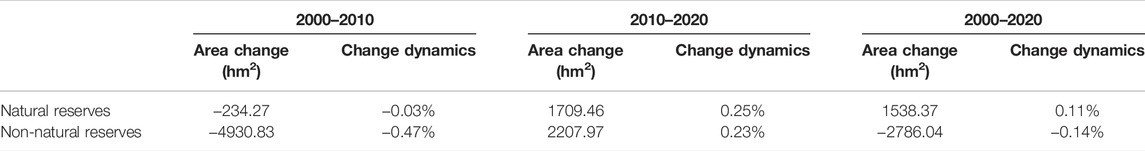
TABLE 3. The overall change in the RRL area in natural reserves and non-natural reserves.
FIGURE 4. The change dynamics and kernel density of the RRL area in natural reserves and non-natural reserves. [Panels (A–C) show the change dynamics of the RRL area in counties of natural reserves and non-natural reserves in 2000–2010, 2010–2020, and 2000–2020, respectively. Panels (D–F) show the kernel density of the RRL area change in counties of natural reserves and non-natural reserves in 2000–2010, 2010–2020, and 2000–2020, respectively.]
Moreover, it is also worth noting that from the change dynamics and kernel density of the RRL area in 2010–2020, the RRL area of non-natural reserves in Zhuzhou and Changde show a significant growth trend, while the counties with a small growth of the RRL area are mainly concentrated in the non-natural reserves in Chenzhou and Yiyang and the natural reserves in Changde and Yueyang. It can also be found that the counties with the increase in the RRL area in 2010–2020 are mainly concentrated in the plain areas with high economic development and dense populations in eastern and northern Hunan. In addition, the RRL area in most regions of Hunan has decreased slightly, while the RRL area in some non-natural reserves in Huaihua and Xiangxi has decreased significantly. Additionally, this study found that urbanization and the poverty alleviation and relocation policy are the main factors for the reduction of RRL in these regions.
Due to the different units and magnitudes of each index, the data are standardized to narrow the fluctuation range of the data to [0,1] to better show the changes to each index and the area of RRL in Hunan Province (Huyan and Li, 2021). Meanwhile, by analyzing the research data, we find that the dependent variable RRL in this article satisfies the normal distribution; the influencing factors are independent of each other as independent variables, and there is no multicollinearity problem, and there is a linear relationship between the dependent variable and the independent variable. Therefore, the research data in this article meet the requirements of using an ordinary least-squares model for analysis (Gómez et al., 2020).
The calculation results of the ordinary least-squares model (Table 4) show that the overall significance level of all models is within 1%. Compared with the R-squared values of various models in 2000, 2010, and 2020, it is found that the MNL-2 model has a better fitting and is more suitable for further research. Overall, the presence of natural reserves has a negative correlation with the area of RRL within the significance level of 5%, indicating that the delimitation of the natural reserve will limit the growth of the area of local RRL to a certain extent. The per capita cultivated land area and the rural resident population are significantly positive at the 1% level, indicating that with the growth of per capita cultivated land area and the rural resident population, the RRL area will also increase. It is worth noting that the urban construction land area did not show a significant correlation in 2010, while the proportion of the primary industry showed a significant negative correlation at the 10% level, indicating the growth of the urban construction land area after 2000. The area of RRL also showed a trend of initial growth and then decline. Meanwhile, the reduction of the proportion of the primary industry will promote the reduction of RRL areas. In addition, there is a significant positive correlation between the per capita crop sowing area in 2000 and the per capita investment in fixed assets in 2020 at the 5% level, indicating that the growth of the crop sowing area and fixed asset investment will also promote the growth of the RRL area.
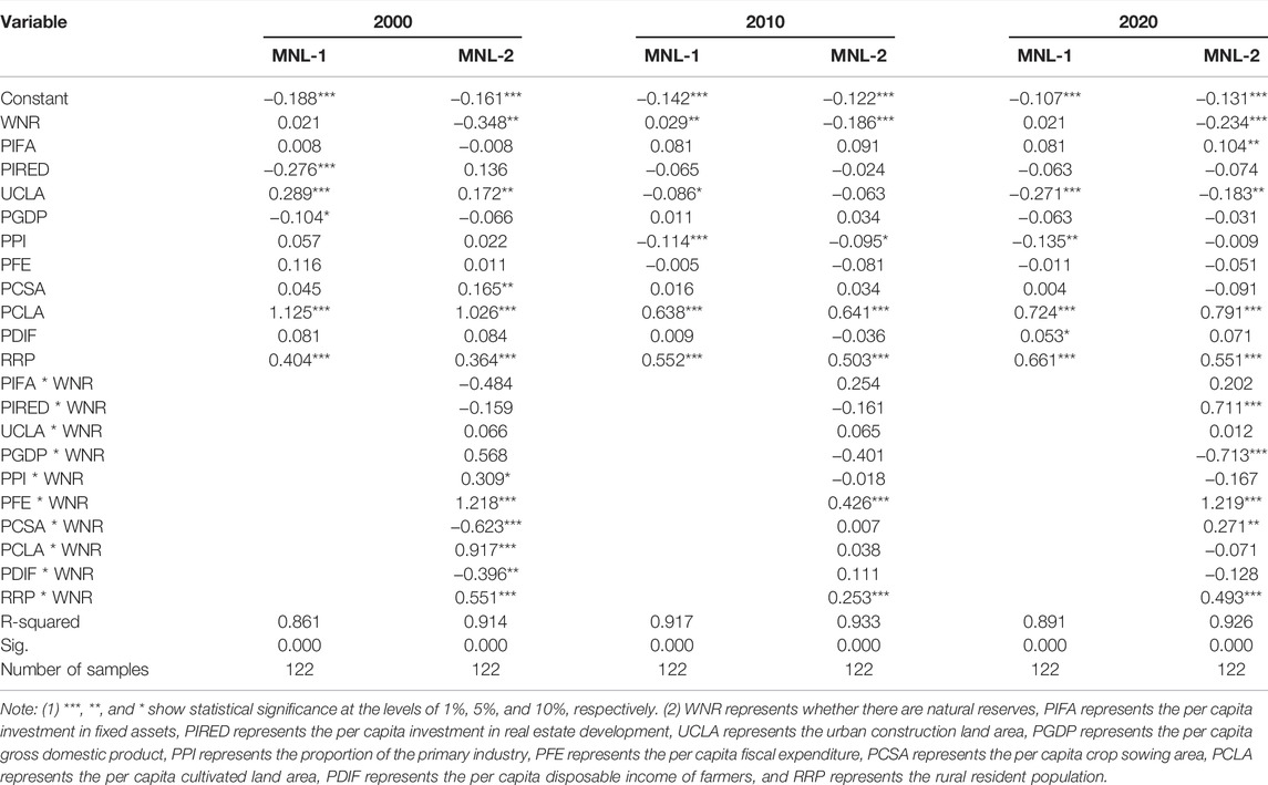
TABLE 4. Ordinary least-squares regression results of influencing factors of RRL.
From the overall results of the interaction analysis of influencing factors, the interaction items of whether there are natural reserves and per capita financial expenditure and whether there are natural reserves and rural resident population are significantly positive at the 5% level, indicating that with the government delimiting the natural reserve, the impact of financial expenditure and rural resident population on the change in the RRL area in the natural reserve will increase. In 2000, the interaction terms of whether there are natural reserves and the proportion of the primary industry and whether there are natural reserves and the per capita cultivated land area were significantly positive at the levels of 10% and 1%, respectively, indicating that the growth of the proportion of the primary industry and the per capita cultivated land area will lead to the growth of the RRL area of the natural reserve. This growth may be because the proportion of the primary industry and the growth of per capita cultivated land area will lead to an increase in rural population, while the growth of farmers’ per capita disposable income will lead to the improvement of rural residents’ consumption ability and accelerate the process of farmers’ urbanization, which restricts the growth of the RRL area. Different from 2000 to 2020, the interaction between whether there were natural reserves and the per capita crop sowing area in 2010 was not significant, while the per capita cultivated land area in 2010 greatly affected the change in the RRL area in the natural reserve. Moreover, it is worth noting that in 2020, the interaction term between whether there are natural reserves and per capita real estate development investment and whether there are natural reserves and per capita GDP is significant, indicating that the delimitation of natural reserves will enhance the impact of GDP on the growth of the RRL area and improve the impact of per capita real estate development investment.
The current RRL area showed a trend of hot in the northeast and cold in the southwest from 2000 to 2020. The hot spots were mainly concentrated in Changsha, Changde, Yueyang, and other cities, while the cold spots were concentrated in some counties of Xiangtan and Huaihua. Among them, economic development was the main factor affecting the increase in RRL (Fan et al., 2019). The difference is that the RRL area in Xiangxi decreased the most (4,417.65 hm2). In addition to economic factors, the government’s policy of poverty alleviation and relocation in other places also has an important impact. In addition, the change dynamics of RRL also show significant spatial differences. The RRL area is growing due to the constraints of economic development and the farmers’ thought of “going home” in eastern Shaoyang and Hengyang. For the counties in the middle of Changsha, east of Xiangtan, and north of Zhuzhou, the demand for urban construction land increases due to the development of the Chang Zhu Tan metropolitan area, which leads to the occupation of RRL, resulting in a significant reduction in the area of RRL (He et al., 2019). Furthermore, we explore the change forms of transfer in and transfer out of RRL and find that the main reason for the reduction of RRL is the occupation of urban construction land, which is mainly caused by the strong demand for urban construction land with rapid urbanization. However, the increase in RRL mainly comes from the cultivated land and forestland around the original RRL. The main reason is that the occupied cultivated land and forestland close to the original RRL are more convenient to develop into new homesteads, and the protection intensity of cultivated land and forestland by the local government is not enough. Moreover, different from other countries and regions, the distribution and change in RRL in Hunan Province of China are not only related to the terrain and socioeconomic development but also closely related to the immigration and relocation policies implemented by the government (Liu et al., 2020).
By analyzing the changes in the RRL area in natural reserves and non-natural reserves from 2000 to 2020, we found that the area of RRL in natural reserves increased by 1,538.37 hm2, while the area of RRL in non-natural reserves decreased by 2,786.04 hm2. Combined with the local social, economic, and policy constraints, it is found that to protect the healthy and sustainable development of the natural environment, the local government has formulated relatively strict land control policies for the natural reserve, limiting the speed of its socioeconomic development and urbanization, resulting in the urbanization development speed of the natural reserve being lower than that of the non-natural reserve. Therefore, the area of RRL in the non-natural reserve shows a significant reduction trend. It is worth noting that although the establishment of natural reserves is negatively correlated with the change of RRL, the RRL area in natural reserves is increasing. The main reason for this increase is that the growth of RRL is affected by many other factors, such as rural economic development and population growth, and the factor of whether there is a natural reserve cannot directly promote the overall reduction of the RRL area.
Meanwhile, some residents who moved to the urban areas did not change their registered residence. To enjoy the dividend policy brought by the establishment of natural reserves, the new rural settlements in the natural reserves were brought to the advantage by their registered residents in rural areas, which to a certain extent led to the increase of the RRL area in the natural reserves (Ristić et al., 2019). It is worth noting that the RRL area in wetland nature reserves, such as the East Dongting Lake National Nature Reserve in Yueyang, increased rapidly in 2000–2020. When analyzing the management policy of the natural reserve, it is found that the management department divides the wetland natural reserve into three levels: core area, test area, and buffer area. The core area is prohibited from development, the test area is moderately developed, and the buffer area is allowed to be fully developed. However, the test area and buffer area do not strictly restrict the expansion of RRL, which leads to the rapid growth of RRL in these areas to a certain extent (Xiao et al., 2021). Although the area of RRL in the natural reserve shows a trend of growth, through the analysis of the ordinary least-squares model, it is found that the presence of natural reserves has a significant negative correlation with the area of RRL, which also shows that the establishment of natural reserves still limits the growth rate of RRL to a certain extent.
Although the spatial distribution change of RRL is the result of the joint action of natural, social, and economic factors (Liu et al., 2019), the establishment of natural reserves limits the change of RRL from the aspects of social economy and land management policies to a certain extent. Through the analysis of the ordinary least-squares model, it is found that the growth of per capita cultivated land area and rural resident population from 2000 to 2020 leads to a large number of farmers living in rural areas, and more RRL is needed to build new houses. The growth of urban construction land area during the early stage has no direct impact on the growth of the RRL area, while the promotion of urbanization needs to absorb a large rural population, and this factor reduces the demand for the RRL area to a certain extent. In addition, the establishment of natural reserves will enhance the impact of government financial expenditure and rural resident population on RRL; that is, in natural reserves, more government financial expenditure and an increase in rural resident population will promote the growth of the RRL area. The per capita crop sowing area from 2000 to 2020 shows the influence of first limiting and then promoting the growth of the RRL area. The summary and analysis can divide the driving factors of RRL change in Hunan Province into three categories: endogenous demand for urbanization development, exogenous catalysis of unbalanced regional development, and policy resettlement measures (Yang et al., 2016). The establishment of natural reserves does not play a decisive role but regulates some factors affecting the change in RRL and then affects the change in the RRL area through the comprehensive action of multiple factors.
The research contributions of this article are as follows: (1) based on the perspective of whether there are natural reserves, this article compares and analyzes the spatiotemporal change characteristics of RRL between natural reserves and non-natural reserves in Hunan Province; and (2) this article analyzes the influencing factors of the RRL area change and explores how the establishment of natural reserves affects RRL.
There are some deficiencies in this study. (1) Although this article selects 11 influencing factors based on the relevant literature and the actual conditions of RRL in Hunan Province, it does not involve the level of subjective factors such as farmers’ will, which requires data to be obtained through field research. (2) Due to the weak protection and policy constraints of county-level natural reserves, this article only considers provincial and national nature reserves. (3) Since the research scale of this article is 122 county-level administrative regions in Hunan Province, the research results of this article may not apply to all regions of China but can provide some reference for regions with similar natural, social, and economic conditions.
Based on the spatial and panel data of 122 county-level administrative regions in Hunan Province, this article analyzes the spatiotemporal distribution characteristics of RRL in natural reserves and non-natural reserves by using land use change dynamics, nuclear density analysis, transfer matrix modeling, and ordinary least-squares modeling and explores how the establishment of natural reserves affects RRL. The results show that (1) affected by rapid urbanization, the overall RRL area in Hunan shifted from 171,162.27 hm2 in 2000 to 169,914.6 hm2 in 2020, with a total reduction of 1,247.67 hm2 and a decrease of 0.73%, and the distribution of the RRL area change presented a hot trend in the northeast and a cold trend in the southwest. (2) The spatial distribution of RRL has significant heterogeneity due to natural conditions. The traditional agricultural areas in the east and northeast of Hunan have high residential density and large land scale, while the RRL in the hills and mountainous areas in the west and southwest of Hunan has low aggregation degree and obvious sporadic distribution characteristics, and the RRL area in western Hunan shows a sharp reduction trend due to immigration policy. (3) The occupation of urban construction land is the main reason for the reduction in RRL area, and the transformation of cultivated land and forestland into RRL is the main source of the increase in the RRL area. (4) There are significant differences in the spatiotemporal variation characteristics of the RRL area between natural reserves and non-natural reserves. The RRL area mainly shows an increasing trend in natural reserves, while it mainly shows a decreasing trend in non-natural reserves. Furthermore, the growth of the RRL area is mainly concentrated in the non-natural reserves in central Hunan and the natural reserves in northeast and northwest China, while the non-natural reserves are the main areas where the RRL area decreases. (5) The establishment of natural reserves cannot directly promote the overall reduction of the RRL area. Although there is a significant negative correlation between the establishment of natural reserves and the area of RRL, the total area of RRL in the natural reserve still shows an increasing trend, indicating that the area of RRL is more affected by economic development, government financial expenditure, rural permanent population, etc. Meanwhile, the per capita cultivated land area and rural resident population promote the growth of the RRL area, while urban construction land initially limits and then promotes the growth of the RRL area from 2000 to 2020.
In addition, this article puts forward the following policy implications for the optimization of RRL in natural reserves. (1) The government should strengthen the planning and management of RRL in natural reserves and relocate RRL that are not suitable for living or have a fragile ecological environment. (2) The government can strictly restrict the construction of new RRL in the natural reserve and protect and merge the original RRL suitable for living in the natural reserve to strictly control the growth of RRL in the natural reserve. (3) If farmers have a high demand for RRL, the local government needs to protect and develop the natural reserve according to local conditions. For example, the construction of new RRL is prohibited in the core zone, and the area of RRL is strictly limited in the experimental zone and buffer zone. (4) The local government should also introduce relevant welfare policies to encourage residents in natural reserves to migrate to non-natural reserves and to reduce the area of RRL in natural reserves.
The original contributions presented in the study are included in the article/Supplementary Material; further inquiries can be directed to the corresponding author.
YW: Formal analysis, software, and writing—review and editing. HT: Conceptualization, formal analysis, data curation, software, visualization, and writing—original draft. PJ: Conceptualization, formal analysis, data curation, software, methodology, supervision, writing—review and editing, and funding acquisition. JC: Data curation. All authors contributed to this article and approved the submitted version.
This research was supported by the National Key Research and Development Program of China (2018YFD1100801).
The authors declare that the research was conducted in the absence of any commercial or financial relationships that could be construed as a potential conflict of interest.
All claims expressed in this article are solely those of the authors and do not necessarily represent those of their affiliated organizations, or those of the publisher, the editors, and the reviewers. Any product that may be evaluated in this article, or claim that may be made by its manufacturer, is not guaranteed or endorsed by the publisher.
The Supplementary Material for this article can be found online at: https://www.frontiersin.org/articles/10.3389/fenvs.2022.909554/full#supplementary-material
Abelairas-Etxebarria, P., and Astorkiza, I. (2012). Farmland Prices and Land-Use Changes in Periurban Protected Natural Areas. Land Use Policy 29, 674–683. doi:10.1016/j.landusepol.2011.11.003
Bai, X., Shi, P., and Liu, Y. (2014). Society: Realizing China's Urban Dream. Nature 509, 158–160. doi:10.1038/509158a
Chen, Z., Liu, Y., Feng, W., Li, Y., and Li, L. (2019). Study on Spatial Tropism Distribution of Rural Settlements in the Loess Hilly and Gully Region Based on Natural Factors and Traffic Accessibility. J. Rural Stud. doi:10.1016/j.jrurstud.2019.02.014
Chirisa, I. (2021). Opportunities in Master and Local Planning for Resilient Rural Settlement in Zimbabwe. J. Rural Stud. 86, 97–105. doi:10.1016/j.jrurstud.2021.05.026
Conrad, C., Rudloff, M., Abdullaev, I., Thiel, M., Löw, F., and Lamers, J. P. A. (2015). Measuring Rural Settlement Expansion in Uzbekistan Using Remote Sensing to Support Spatial Planning. Appl. Geogr. 62, 29–43. doi:10.1016/j.apgeog.2015.03.017
Cyriac, S., and Firoz, M. (2022). Dichotomous Classification and Implications in Spatial Planning: A Case of the Rural-Urban Continuum Settlements of Kerala, India. Land Use Policy 114, 105992. doi:10.1016/j.landusepol.2022.105992
Deng, Z., Dai, L., Deng, L., and Peng, P. (2021). Analysis of Farmers' Perceptions and Behavioral Response to Rural Living Environment Renovation in a Major Rice-Producing Area: a Case of Dongting Lake Wetland, China. Cienc. Rural. 51, e20200847. doi:10.1590/0103-8478cr20200847
Ding, M., Liu, W., Xiao, L., Zhong, F., Lu, N., Zhang, J., et al. (2022). Construction and Optimization Strategy of Ecological Security Pattern in a Rapidly Urbanizing Region: A Case Study in Central-South China. Ecol. Indic. 136, 108604. doi:10.1016/j.ecolind.2022.108604
Elgammal, A., Duraiswami, R., Harwood, D., and Davis, L. S. (2002). Background and Foreground Modeling Using Nonparametric Kernel Density Estimation for Visual Surveillance. Proc. IEEE 90, 1151–1163. doi:10.1109/JPROC.2002.801448
Fan, J., Han, Q., Tan, S., and Li, J. (2022). Evaluation of Six Satellite-Based Soil Moisture Products Based on In Situ Measurements in Hunan Province, Central China. Front. Environ. Sci. 10, 1–12. doi:10.3389/fenvs.2022.829046
Fan, P., Ouyang, Z., Nguyen, D. D., Nguyen, T. T. H., Park, H., and Chen, J. (2019). Urbanization, Economic Development, Environmental and Social Changes in Transitional Economies: Vietnam after Doimoi. Landsc. Urban Plan. 187, 145–155. doi:10.1016/j.landurbplan.2018.10.014
Fernández, J. E. (2007). Resource Consumption of New Urban Construction in China. J. Ind. Ecol. 11, 99–115. doi:10.1162/jie.2007.1199
Gallant, A. L., Loveland, T. R., Sohl, T. L., and Napton, D. E. (2004). Using an Ecoregion Framework to Analyze Land-Cover and Land-Use Dynamics. Environ. Manag. 34 (Suppl. 1), S89–S110. doi:10.1007/s00267-003-0145-3
Gao, J., Liu, Y., Chen, J., and Cai, Y. (2019). Demystifying the Geography of Income Inequality in Rural China: A Transitional Framework. J. Rural Stud. doi:10.1016/j.jrurstud.2019.01.010
Gong, J., Jian, Y., Chen, W., Liu, Y., and Hu, Y. (2019). Transitions in Rural Settlements and Implications for Rural Revitalization in Guangdong Province. J. Rural Stud. doi:10.1016/j.jrurstud.2019.10.037
Gosch, M. S., Parente, L. L., Santos, C. O. d., Mesquita, V. V., and Ferreira, L. G. (2021). Landsat-based Assessment of the Quantitative and Qualitative Dynamics of the Pasture Areas in Rural Settlements in the Cerrado Biome, Brazil. Appl. Geogr. 136, 102585. doi:10.1016/j.apgeog.2021.102585
Guan, X., Wei, H., Lu, S., Dai, Q., and Su, H. (2018). Assessment on the Urbanization Strategy in China: Achievements, Challenges and Reflections. Habitat Int. 71, 97–109. doi:10.1016/j.habitatint.2017.11.009
Han, Z., Jiao, S., Zhang, X., Xie, F., Ran, J., Jin, R., et al. (2021). Seeking Sustainable Development Policies at the Municipal Level Based on the Triad of City, Economy and Environment: Evidence from Hunan Province, China. J. Environ. Manag. 290, 112554. doi:10.1016/j.jenvman.2021.112554
He, Y., Zhou, G., Tang, C., Fan, S., and Guo, X. (2019). The Spatial Organization Pattern of Urban-Rural Integration in Urban Agglomerations in China: An Agglomeration-Diffusion Analysis of the Population and Firms. Habitat Int. 87, 54–65. doi:10.1016/j.habitatint.2019.04.003
Heng, J., Wang, H., Fan, Y., Wang, Z., and Gao, Y. (2021). Simulation and Optimization of Urban–Rural Settlement Development from the Perspective of Production–Life–Ecology Space: A Case Study for Aksu City. Sustainability 13, 7452. doi:10.3390/su13137452
Hoffman-Hall, A., Loboda, T. V., Hall, J. V., Carroll, M. L., and Chen, D. (2019). Mapping Remote Rural Settlements at 30 M Spatial Resolution Using Geospatial Data-Fusion. Remote Sens. Environ. 233, 111386. doi:10.1016/j.rse.2019.111386
Huang, Q., Song, W., and Song, C. (2020). Consolidating the Layout of Rural Settlements Using System Dynamics and the Multi-Agent System. J. Clean. Prod. 274, 123150. doi:10.1016/j.jclepro.2020.123150
Huyan, W., and Li, J. (2021). Research on Rural Tourism Service Intellectualization Based on Neural Network Algorithm and Optimal Classification Decision Function. J. Ambient. Intell. Hum. Comput. doi:10.1007/s12652-021-03039-6
Kong, X., Liu, D., Tian, Y., and Liu, Y. (2021). Multi-objective Spatial Reconstruction of Rural Settlements Considering Intervillage Social Connections. J. Rural Stud. 84, 254–264. doi:10.1016/j.jrurstud.2019.02.028
Li, G., Jiang, C., Du, J., Jia, Y., and Bai, J. (2020a). Spatial Differentiation Characteristics of Internal Ecological Land Structure in Rural Settlements and its Response to Natural and Socio-Economic Conditions in the Central Plains, China. Sci. Total Environ. 709, 135932. doi:10.1016/j.scitotenv.2019.135932
Li, G., Jiang, G., Jiang, C., and Bai, J. (2018a). Differentiation of Spatial Morphology of Rural Settlements from an Ethnic Cultural Perspective on the Northeast Tibetan Plateau, China. Habitat Int. 79, 1–9. doi:10.1016/j.habitatint.2018.06.002
Li, J., Lo, K., Zhang, P., and Guo, M. (2021a). Reclaiming Small to Fill Large: A Novel Approach to Rural Residential Land Consolidation in China. Land Use Policy 109, 105706. doi:10.1016/j.landusepol.2021.105706
Li, K., Geng, H., Yue, L., Li, K., and Huang, L. (2021b). Spatial Differentiation Characteristics and Driving Mechanism of Rural Settlements Transformation in the Metropolis: A Case Study of Pudong District, Shanghai. Front. Environ. Sci. 9, 1–16. doi:10.3389/fenvs.2021.755207
Li, L., Li, X., Hai, B., Wang, X., and Xu, J. (2020b). Evolution of Rural Settlement in an Inland Nonmetropolitan Region of China at a Time of Rapid Urbanisation: The Case of Gongyi. J. Rural Stud. 79, 45–56. doi:10.1016/j.jrurstud.2020.08.003
Li, S., Zhu, C., Lin, Y., Dong, B., Chen, B., Si, B., et al. (2021c). Conflicts between Agricultural and Ecological Functions and Their Driving Mechanisms in Agroforestry Ecotone Areas from the Perspective of Land Use Functions. J. Clean. Prod. 317, 128453. doi:10.1016/j.jclepro.2021.128453
Li, Y., Jia, L., Wu, W., Yan, J., and Liu, Y. (2018b). Urbanization for Rural Sustainability - Rethinking China's Urbanization Strategy. J. Clean. Prod. 178, 580–586. doi:10.1016/j.jclepro.2017.12.273
Li, Y., Kong, X., and Zhu, Z. (2020c). Multiscale Analysis of the Correlation Patterns between the Urban Population and Construction Land in China. Sustain. Cities Soc. 61, 102326. doi:10.1016/j.scs.2020.102326
Li, Y., Liu, Y., Long, H., and Cui, W. (2014). Community-based Rural Residential Land Consolidation and Allocation Can Help to Revitalize Hollowed Villages in Traditional Agricultural Areas of China: Evidence from Dancheng County, Henan Province. Land Use Policy 39, 188–198. doi:10.1016/j.landusepol.2014.02.016
Liang, Z., and Qamruzzaman, M. (2022). An Asymmetric Investigation of the Nexus between Economic Policy Uncertainty, Knowledge Spillover, Climate Change, and Green Economy: Evidence from BRIC Nations. Front. Environ. Sci. 9, 1–16. doi:10.3389/fenvs.2021.807424
Lin, H., Wang, H., Wang, J., Yin, J., and Yang, J. (2022). A Novel Ship Detection Method via Generalized Polarization Relative Entropy for PolSAR Images. IEEE Geosci. Remote Sens. Lett. 19, 1–5. doi:10.1109/LGRS.2020.3019196
Linard, C., Gilbert, M., Snow, R. W., Noor, A. M., and Tatem, A. J. (2012). Population Distribution, Settlement Patterns and Accessibility across Africa in 2010. PLoS One 7, e31743. doi:10.1371/journal.pone.0031743
Liu, M., Feng, X., Wang, S., and Qiu, H. (2020). China’s poverty alleviation over the last 40 years: successes and challenges†. Aust. J. Agric. Resour. Econ. 64, 209–228. doi:10.1111/1467-8489.12353
Liu, W., Henneberry, S. R., Ni, J., Radmehr, R., and Wei, C. (2019). Socio-cultural Roots of Rural Settlement Dispersion in Sichuan Basin: The Perspective of Chinese Lineage. Land Use Policy 88, 104162. doi:10.1016/j.landusepol.2019.104162
Liu, Y., Kong, X., Liu, Y., and Chen, Y. (2013). Simulating the Conversion of Rural Settlements to Town Land Based on Multi-Agent Systems and Cellular Automata. PLoS One 8, e79300–14. doi:10.1371/journal.pone.0079300
Liu, Y., and Li, Y. (2017). Revitalize the World’s Countryside. Nature 548, 275–277. doi:10.1038/548275a
Liu, Y., Yang, Y., Li, Y., and Li, J. (2017). Conversion from Rural Settlements and Arable Land under Rapid Urbanization in Beijing during 1985-2010. J. Rural Stud. 51, 141–150. doi:10.1016/j.jrurstud.2017.02.008
Liu, Y., Ye, Q., Li, J., Kong, X., and Jiao, L. (2016). Suitability Evaluation of Rural Settlements Based on Accessibility of Production and Living: A Case Study of Tingzu Town in Hubei Province of China. Chin. Geogr. Sci. 26, 550–565. doi:10.1007/s11769-015-0771-0
Long, H., Li, Y., Liu, Y., Woods, M., and Zou, J. (2012). Accelerated restructuring in rural China fueled by ‘increasing vs. decreasing balance’ land-use policy for dealing with hollowed villages. Land Use Policy 29, 11–22. doi:10.1016/j.landusepol.2011.04.003
Ma, W., Jiang, G., Wang, D., Li, W., Guo, H., and Zheng, Q. (2018). Rural Settlements Transition (RST) in a Suburban Area of Metropolis: Internal Structure Perspectives. Sci. Total Environ. 615, 672–680. doi:10.1016/j.scitotenv.2017.09.152
Martin, C. E., and Chehébar, C. (2001). The National Parks of Argentinian Patagonia - Management Policies for Conservation, Public Use, Rural Settlements, and Indigenous Communities. J. Roy. Soc. New Zeal. 31, 845–864. doi:10.1080/03014223.2001.9517680
Nandi, S., and Mistri, T. (2022). Transformation of Rural Settlement in Salanpur Community Development Block, West Bengal, India. GeoJournal 5, 214–221. doi:10.1007/s10708-021-10565-5
Njoh, A. J. (2011). Municipal Councils, International NGOs and Citizen Participation in Public Infrastructure Development in Rural Settlements in Cameroon. Habitat Int. 35, 101–110. doi:10.1016/j.habitatint.2010.04.001
Öztürk, M., Copty, N. K., and Saysel, A. K. (2013). Modeling the Impact of Land Use Change on the Hydrology of a Rural Watershed. J. Hydrology 497, 97–109. doi:10.1016/j.jhydrol.2013.05.022
Phokaides, P. (2018). Rural networks and planned communities: Doxiadis Associates’ plans for rural settlements in post-independence Zambia. J. Archit. 23, 471–497. doi:10.1080/13602365.2018.1458044
Qu, Y., Jiang, G., Zhao, Q., Ma, W., Zhang, R., and Yang, Y. (2017). Geographic Identification, Spatial Differentiation, and Formation Mechanism of Multifunction of Rural Settlements: A Case Study of 804 Typical Villages in Shandong Province, China. J. Clean. Prod. 166, 1202–1215. doi:10.1016/j.jclepro.2017.08.120
Qu, Y., Jiang, G., Ma, W., and Li, Z. (2021). How Does the Rural Settlement Transition Contribute to Shaping Sustainable Rural Development? Evidence from Shandong, China. J. Rural Stud. 82, 279–293. doi:10.1016/j.jrurstud.2021.01.027
Ristić, D., Vukoičić, D., and Milinčić, M. (2019). Tourism and sustainable development of rural settlements in protected areas - Example NP Кopaonik (Serbia). Land Use Policy 89, 104231. doi:10.1016/j.landusepol.2019.104231
Romero-Calcerrada, R., and Perry, G. L. W. (2004). The role of land abandonment in landscape dynamics in the SPA 'Encinares del rı́o Alberche y Cofio, Central Spain, 1984-1999. Landsc. Urban Plan. 66, 217–232. doi:10.1016/S0169-2046(03)00112-9
Rosner, A., and Wesołowska, M. (2020). Deagrarianisation of the Economic Structure and the Evolution of Rural Settlement Patterns in Poland. Land 9, 523–619. doi:10.3390/land9120523
Gómez, R., Rodríguez Sánchez, A., García, C. G., and García Pérez, J. (2020). The VIF and MSE in Raise Regression. Mathematics 8, 605–628. doi:10.3390/math8040605
Sanchez, J. M. (2020). Linear Calibrations in Chromatography: The Incorrect Use of Ordinary Least Squares for Determinations at Low Levels, and the Need to Redefine the Limit of Quantification with This Regression Model. J. Sep. Sci. 43, 2708–2717. doi:10.1002/jssc.202000094
Shcherbina, E., and Gorbenkova, E. (2019). Factors Influencing the Rural Settlement Development. IFAC-PapersOnLine 52, 231–235. doi:10.1016/j.ifacol.2019.12.478
Stumpf, F., Keller, A., Schmidt, K., Mayr, A., Gubler, A., and Schaepman, M. (2018). Spatio-temporal Land Use Dynamics and Soil Organic Carbon in Swiss Agroecosystems. Agric. Ecosyst. Environ. 258, 129–142. doi:10.1016/j.agee.2018.02.012
Suh, J. (2015). Communitarian Cooperative Organic Rice Farming in Hongdong District, South Korea. J. Rural Stud. 37, 29–37. doi:10.1016/j.jrurstud.2014.11.009
Sun, P., Zhou, L., Ge, D., Lu, X., Sun, D., Lu, M., et al. (2021). How Does Spatial Governance Drive Rural Development in China's Farming Areas? Habitat Int. 109, 102320. doi:10.1016/j.habitatint.2021.102320
Tan, M. J., and Guan, C. (2021). Are People Happier in Locations of High Property Value? Spatial Temporal Analytics of Activity Frequency, Public Sentiment and Housing Price Using Twitter Data. Appl. Geogr. 132, 102474. doi:10.1016/j.apgeog.2021.102474
Tan, S., Zhang, M., Wang, A., and Ni, Q. (2021). Spatio-Temporal Evolution and Driving Factors of Rural Settlements in Low Hilly Region-A Case Study of 17 Cities in Hubei Province, China. Int. J. Environ. Res. Public Health 18, 2387–2418. doi:10.3390/ijerph18052387
Tang, C., He, Y., Zhou, G., Zeng, S., and Xiao, L. (2018). Optimizing the Spatial Organization of Rural Settlements Based on Life Quality. J. Geogr. Sci. 28, 685–704. doi:10.1007/s11442-018-1499-4
Trukhachev, A. (2015). Methodology for Evaluating the Rural Tourism Potentials: A Tool to Ensure Sustainable Development of Rural Settlements. Sustainability 7, 3052–3070. doi:10.3390/su7033052
Tu, S., Long, H., Zhang, Y., Ge, D., and Qu, Y. (2018). Rural Restructuring at Village Level under Rapid Urbanization in Metropolitan Suburbs of China and its Implications for Innovations in Land Use Policy. Habitat Int. 77, 143–152. doi:10.1016/j.habitatint.2017.12.001
Wang, J., and Zhang, Y. (2021). Analysis on the Evolution of Rural Settlement Pattern and its Influencing Factors in China from 1995 to 2015. Land 10, 1137. doi:10.3390/land10111137
Wen, Y., Zhang, Z., Liang, D., and Xu, Z. (2020). Rural Residential Land Transition in the Beijing-Tianjin-Hebei Region: Spatial-Temporal Patterns and Policy Implications. Land Use Policy 96, 104700. doi:10.1016/j.landusepol.2020.104700
Wu, Y., Shan, L., Guo, Z., and Peng, Y. (2017). Cultivated Land Protection Policies in China Facing 2030: Dynamic Balance System versus Basic Farmland Zoning. Habitat Int. 69, 126–138. doi:10.1016/j.habitatint.2017.09.002
Xiao, J., Watanabe, T., Lu, X., Chand, M. B., Umarhadi, D. A., Chen, X., et al. (2021). Integrating Land Use/land Cover Change with Change in Functional Zones’ Boundary of the East Dongting Lake National Nature Reserve, China. Phys. Chem. Earth, Parts A/B/C 126, 103041. doi:10.1016/j.pce.2021.103041
Xue, J., Lyu, D., Wang, D., Wang, Y., Yin, D., Zhao, Z., et al. (2018). Assessment of Soil Erosion Dynamics Using the GIS-Based RUSLE Model: A Case Study of Wangjiagou Watershed from the Three Gorges Reservoir Region, Southwestern China. Water 10, 1817. doi:10.3390/w10121817
Yang, J., Song, C., Yang, Y., Xu, C., Guo, F., and Xie, L. (2019a). New Method for Landslide Susceptibility Mapping Supported by Spatial Logistic Regression and GeoDetector: A Case Study of Duwen Highway Basin, Sichuan Province, China. Geomorphology 324, 62–71. doi:10.1016/j.geomorph.2018.09.019
Yang, J., Yang, J., Luo, X., and Huang, C. (2019b). Impacts by Expansion of Human Settlements on Nature Reserves in China. J. Environ. Manag. 248, 109233. doi:10.1016/j.jenvman.2019.07.004
Yang, R., Xu, Q., and Long, H. (2016). Spatial Distribution Characteristics and Optimized Reconstruction Analysis of China's Rural Settlements during the Process of Rapid Urbanization. J. Rural Stud. 47, 413–424. doi:10.1016/j.jrurstud.2016.05.013
Yang, R., Xu, Q., Xu, X., and Chen, Y. (2019c). Rural Settlement Spatial Patterns and Effects: Road Traffic Accessibility and Geographic Factors in Guangdong Province, China. J. Geogr. Sci. 29, 213–230. doi:10.1007/s11442-019-1593-2
Yang, Y., Liu, Y., Li, Y., and Du, G. (2018). Quantifying Spatio-Temporal Patterns of Urban Expansion in Beijing during 1985-2013 with Rural-Urban Development Transformation. Land Use Policy 74, 220–230. doi:10.1016/j.landusepol.2017.07.004
Yao, G., and Xie, H. (2016). Rural Spatial Restructuring in Ecologically Fragile Mountainous Areas of Southern China: A Case Study of Changgang Town, Jiangxi Province. J. Rural Stud. 47, 435–448. doi:10.1016/j.jrurstud.2016.07.014
You, L., and Chen, C. (2019). Planning and Implementing Smart Shrinkage of Rural China: The Case of Chengdu’s Rural Settlement Consolidation with SGME Model. jrcp 30, 62–75. doi:10.5614/jpwk.2019.30.1.5
Yu, Z., Xiao, L., Chen, X., He, Z., Guo, Q., and Vejre, H. (2018). Spatial Restructuring and Land Consolidation of Urban-Rural Settlement in Mountainous Areas Based on Ecological Niche Perspective. J. Geogr. Sci. 28, 131–151. doi:10.1007/s11442-018-1464-2
Zasada, I., and Piorr, A. (2015). The Role of Local Framework Conditions for the Adoption of Rural Development Policy: An Example of Diversification, Tourism Development and Village Renewal in Brandenburg, Germany. Ecol. Indic. 59, 82–93. doi:10.1016/j.ecolind.2015.02.002
Zhou, D., Wang, Z., Lassoie, J., Wang, X., and Sun, L. (2014). Changing Stakeholder Relationships in Nature Reserve Management: A Case Study on Snake Island-Laotie Mountain National Nature Reserve, Liaoning, china. J. Environ. Manag. 146, 292–302. doi:10.1016/j.jenvman.2014.07.018
Zhou, G., He, Y., Tang, C., Yu, T., Xiao, G., and Zhong, T. (2013). Dynamic Mechanism and Present Situation of Rural Settlement Evolution in China. J. Geogr. Sci. 23, 513–524. doi:10.1007/s11442-013-1025-7
Zhou, J., Hua, C., Wu, S., Wang, Z., and Wang, X. (2021). Sustainable Village Planning Indicator System in Rural Transformation: Application to Xufu Village in the Yangtze River Delta Region in China. J. Urban Plann. Dev. 147, 05021050. doi:10.1061/(asce)up.1943-5444.0000768
Zhou, W., and Chen, B. (2006). Biodiversity of Bitahai Nature Reserve in Yunnan Province, China. Biodivers. Conserv. 15, 839–853. doi:10.1007/s10531-004-1869-3
Zhou, Z., Liu, J., Zeng, H., Zhang, T., and Chen, X. (2020). How does soil pollution risk perception affect farmers' pro-environmental behavior? The role of income level. J. Environ. Manag. 270, 110806. doi:10.1016/j.jenvman.2020.110806
Zhu, F., Zhang, F., Li, C., and Zhu, T. (2014). Functional Transition of the Rural Settlement: Analysis of Land-Use Differentiation in a Transect of Beijing, China. Habitat Int. 41, 262–271. doi:10.1016/j.habitatint.2013.07.011
Keywords: rural residential land, natural reserves, driving factors, China, spatiotemporal variation characteristics
Citation: Wu Y, Tang H, Jiang P and Chen J (2022) What Is the Impact of the Establishment of Natural Reserves on Rural Residential Land? An Empirical Study From Hunan Province, China. Front. Environ. Sci. 10:909554. doi: 10.3389/fenvs.2022.909554
Received: 31 March 2022; Accepted: 06 May 2022;
Published: 24 June 2022.
Edited by:
Jiaxing Cui, Central China Normal University, ChinaReviewed by:
Shuyao Wu, Shandong University, ChinaCopyright © 2022 Wu, Tang, Jiang and Chen. This is an open-access article distributed under the terms of the Creative Commons Attribution License (CC BY). The use, distribution or reproduction in other forums is permitted, provided the original author(s) and the copyright owner(s) are credited and that the original publication in this journal is cited, in accordance with accepted academic practice. No use, distribution or reproduction is permitted which does not comply with these terms.
*Correspondence: Ping Jiang, bG9uZ2thbmdrYW5nQHdodS5lZHUuY24=
Disclaimer: All claims expressed in this article are solely those of the authors and do not necessarily represent those of their affiliated organizations, or those of the publisher, the editors and the reviewers. Any product that may be evaluated in this article or claim that may be made by its manufacturer is not guaranteed or endorsed by the publisher.
Research integrity at Frontiers
Learn more about the work of our research integrity team to safeguard the quality of each article we publish.