 Libang Ma
 Yao Yao1
- 1College of Geography and Environmental Science, Northwest Normal University, Lanzhou, China
- 2Key Laboratory of Resource Environment and Sustainable Development of Oasis, Lanzhou, China
- 3Institute of Urban and Rural Development and Collaborative Governance of Northwest, Lanzhou, China
Studying the gradient differentiation of rural ecological land (REL) from a microscopic perspective is conducive to the pattern optimization, scientific control, and protection of REL. This has far-reaching significance for the improvement of village appearance and the delineation of an ecological safety network. Taking Longxi County as an example, this research studied the spatial pattern of REL based on the landscape pattern index and analyzed the multi-dimensional gradient spatial differentiation characteristics of REL. Therefore, we can clarify the impact of natural and human factors on EL under different gradients. The results show 1) the rural ecological background conditions of Longxi County are good, and the area of ecological land (EL) accounts for 90.45% of the total area of the county; 2) there are significant differences between the spatial feature index and spatial pattern of REL in Longxi County. Its diversity, dominance, and shape index were mainly at low and medium levels. The degrees of fragmentation were mainly at low and high levels; and 3) the REL in Longxi County has different evolution laws in different gradients.
1 Introduction
Ecological land (EL) has ecological functions such as water conservation, soil protection, climate regulation, environmental purification, and biodiversity protection. As a “barometer” (Yu et al., 2015) for measuring ecological quality, EL plays an important role in balancing regional and global ecosystems (Colding, 2007; Feng et al., 2021a), ensuring national land ecological security, coping with global climate change, and improving the quality of human life (Guan et al., 2018). However, with the global environmental change and the disturbance of human activities (Song et al., 2015), EL is facing more serious problems of loss and degradation than ever before (Puskás et al., 2021). These problems not only destroy the balance of the ecosystem but also have a serious impact on the quality of life of future generations (Folke et al., 2004). These issues have attracted widespread attention from academia and governments. To solve this problem, the United Nations has implemented a series of initiatives such as the 2030 Agenda for Sustainable Development and the Convention on Biological Diversity [Tóth et al., 2018; UNCCD (United Nations Convention to Combat Desertification), 2017]. As an important part of ecological space, rural ecological land (REL) not only provides ecological support for various production and living activities in rural areas but also plays an important role in guaranteeing the comprehensive and sustainable development of the social economy in rural areas (Yao et al., 2021). The quantity and spatial distribution of REL will have an important impact on rural livability. REL is used as a “buffer zone” for slowing down the destruction of EL in the loess hilly area (Li et al., 2020a). Studying the multi-dimensional gradient differentiation of EL and its influence mechanism has far-reaching significance for the pattern optimization, scientific control and protection of REL, and the maintenance of the ecosystem in arid areas.
In recent years, the spatial pattern of REL has been affected by various factors. In the period of low social productivity, it is mainly affected by the natural environment, such as topography and climate (Sevenant and Antrop, 2007). Since the 20th century, with the acceleration of global industrialization, urbanization, and informatization, both developed and developing countries have faced significant improvements in rural production and living standards, increasing land use intensity, and increasing demand for construction land. Socio-economic factors have gradually become the main factors affecting the spatial pattern of EL use (Li et al., 2020b). EL in developed countries such as Europe and North America is first affected by socio-economic aspects such as traffic conditions and geographic location (Gonzalez-Abraham et al., 2007; Peng et al., 2016; Gong et al., 2018). In China, there is a strong “land grab” phenomenon between ecological protection and economic development (Fei et al., 2020), which seriously affects the regional ecological security and the sustainable development of the rural ecological environment. How to avoid a series of problems such as the encroachment of rural ecological space, ecological destruction, environmental pollution, and disorderly development of land space has become a practical problem that needs to be solved urgently today. Therefore, it is of great significance to study the spatial pattern of EL and analyze the distribution type, fragmentation degree, concentration, and shape complexity of REL under different natural geographical environments and socio-economic backgrounds for guiding future EL protection and promoting the optimization of REL use pattern.
In recent years, with the in-depth study of rural land ecosystems and the concept of EL, the classification system of EL has been further developed. The classification of EL types from the perspective of land use/land cover has become a method recognized by the academic community. Foreign countries pay more attention to ecological attributes in land use classification and land use management (Deng et al., 2009). Most of the classification of EL is carried out according to the natural characteristics and ecological significance of the land (Frondoni et al., 2011; Qu et al., 2019), and the classification results of EL are used in various research. Pickett et al. (2001)applied the EL classification system to the assessment of environmental conditions. Wassmann et al. (2011)used it to estimate ecological functions, and Capotorti et al. (2012)used it to protect regional biodiversity. In 1898, E. Howard et al. put forward the theory of “garden city,” changing the structure of urban and suburban land and alleviating the environmental damage, thereby beginning to study the ecological landscape pattern (Zube, 1986). Hietala-Koivu (1999) studied the evolution of agricultural landscape patterns in southwestern Finland by landscape index analysis. Seppelt and Voinov (2002) optimized the spatial structure of watershed land use by constructing an ecological security pattern . L. Pamela used remote sensing technology and ground observation data to study the dynamic changes in the ecological landscape (Nngler et al., 2008). Joppa assessed the effectiveness of nature reserves to protect species diversity (Joppa and Pfaff, 2011). The research on El by early Chinese scholars mostly focused on the definition of EL (Deng et al., 2009; Yu et al., 2015), the identification of EL (Zhou et al., 2015; Fei et al., 2020; Liu et al., 2021), the construction of the classification system (Yu et al., 2015), the analysis based on landscape security pattern (Yu et al., 2009; Li et al., 2011), the identification and protection of ecological space (Li et al., 2016), and the relationship between EL and cities (Wang and Li, 2006; Su et al., 2007). In 2017, after the implementation of China’s “Land Use Status Classification System” (GB/T 21010–2017), there was a renewed upsurge in the study of EL. In recent years, the research focus has mainly been on ecosystem service function and value assessment (Guan et al., 2018; Qu et al., 2019), pattern change and differentiation trend (Wei et al., 2021), and protection effectiveness assessment (Gao et al., 2021). Existing research shows that the research on EL has gradually evolved from qualitative to quantitative and specific, and more emphasis has been placed on the optimization and management of EL patterns.
However, there are still some urgent problems to be solved in the current research. For example, the research on REL started late, and the research content mostly focuses on the identification, classification, and protection of EL. The research areas are mostly concentrated in typical key ecological function areas and suburban areas, ignoring the importance of REL as a powerful reserve for the ecological resource in China. In addition, there is currently a lack of research on the differentiation characteristics of the spatial pattern of REL from a gradient perspective. The existing research on the spatial gradient of land is mainly analyzed from the perspective of a single gradient such as topography and economy. With the rapid development of society and economy and the need to revitalize the world’s rural areas, the scientific protection and rational utilization of REL are increasingly important (Li et al., 2020b). This is an essential foundation for the comprehensive and sustainable development of rural society and economy and an essential means to supplement and improve urban functions. Therefore, there is an urgent need to carry out research on the differential mechanism of REL and the impact of different gradients on the spatial distribution of REL.
Longxi County is located in the hilly loess area of Longzhong, with complex and fragmented topography and a fragile ecological environment. Ecological space protection and utilization are crucial in northwest China, considering the significant differences in topographic conditions, per capita income, and town development levels in different regions of Longxi County. Based on the topographical, economic, and administrative gradient differences of “ecological land-dimensional space,” this study comprehensively studied the gradient differences in the spatial structure of REL from multiple dimensions, thereby strengthening the comprehensiveness of geographical gradient research. The main purpose of this study is to explore the gradient differentiation characteristics and laws of REL under different gradients, analyze the impact of different terrains, township development levels, and economic income on the spatial differentiation of REL, and explain its impact mechanism. It is expected to provide a scientific basis for the rational layout, scientific management and control, optimal protection, and sustainable utilization of REL in the loess hilly area of Longzhong. This provides a case reference for the construction of an ecological safety network in the inland areas of northwest China and other places.
The topographic, economic, and administrative gradient differences of “ecological land-dimensional space,” take the administrative village as the evaluation unit to reveal the REL structure. The main purpose is to explore the gradient differentiation characteristics and laws of REL under different gradients, analyze the impact of different terrains, township development levels, and economic income on the spatial differentiation of REL, and explain its impact mechanism on EL (Li et al., 2020b). It is expected to provide a scientific basis for the rational layout (Wei et al., 2021), optimal protection, and intensive utilization of REL in the hilly loess area of Longzhong, and provide new ideas and methods for timely adjustment of REL management and improvement of REL management policies, and provide technical support for constructing an ecological safety network in the northwest inland area.
2 Study Areas and Data
2.1 Overview of the Study Areas
Longxi County is located in the southeast of Gansu Province, China, in the middle of Dingxi City (34°50′-35°23′N, 104°18′-104°54′E), with a total area of 2,408 km2 (Figure 1). The elevation of Longxi County is between 1, 612–2, 762 m. Since Longxi County is located between the edge of the northwest Loess Plateau and the hilly area of the Qinling Mountain and accompanied by the Wei River flowing from west to east. The loess hills and valleys are high in the northwest and low in the southeast. The northern part of Longxi County is in the loess hills and gully area, the middle part is in the valley plain landform, the south part is in the middle and low hills, the middle and north part is in the temperate arid area, and the south part is in the warm and cold semi-humid area. The geographical environment has significant spatial differences. Longxi County has a temperate continental monsoon climate with four seasons, abundant sunshine, and a mild climate. The average annual temperature is 8.1°C. The annual sunshine hours are 2, 210 h. The annual rainfall is 415 mm, and the annual frost-free period is 160 days.
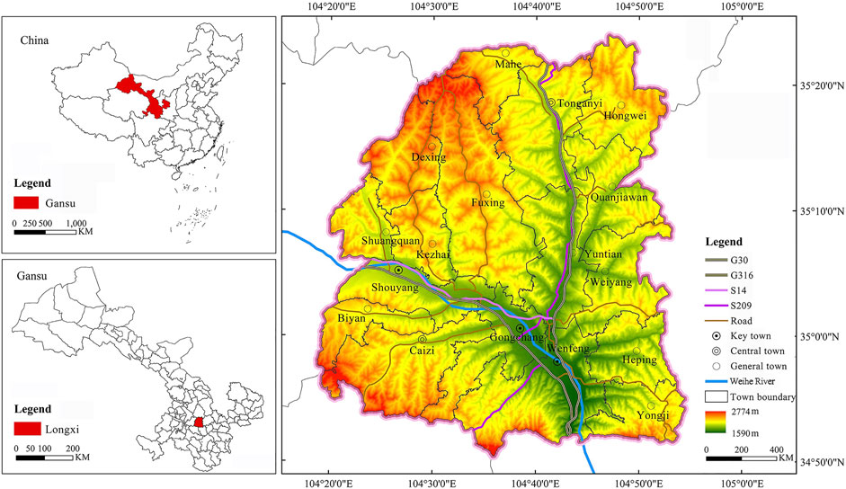
FIGURE 1. Location of Longxi County.
The superior geographical location and suitable natural environment of Longxi County not only laid a material foundation for early agricultural production but also provided an ideal settlement for the ancestors to thrive. Longxi County governs 12 towns, 5 townships, 213 administrative villages, 11 communities, and 1, 287 villager groups. The total population is 52.48 × 10⁴, of which the agricultural population is 43.3 × 10⁴, accounting for 82.51% of the total population (Longxi County Statistical Bulletin 2020). Longxi County has 11.06 × 10⁴ km2 of arable land, and the per capita arable land is only 0.25 km2 (Longxi County People’s Government, 2020). In recent years, with the acceleration of urbanization and rapid socio-economic development, the flow of population, land, and other elements between urban and rural areas has accelerated, resulting in significant changes in the quantity and structure of rural EL. Longxi County is a typical ecologically sensitive area in the inland northwest China. The fragile ecological environment and unique loess plateau landforms have created a series of ecological and environmental problems such as drought and fragmentation of the surface, ecological severe land loss, and decline in soil quality. This has a significant impact on the quality of the ecological environment and the service functions of the ecosystem. Therefore, it is of great significance to study the spatial distribution and multi-dimensional gradient differentiation characteristics of EL in Longxi County for ecological environment protection and the maintenance of ecosystem stability in the northwest inland region.
2.2 Data Source
This study took 213 administrative villages outside the built-up area of Longxi County as the evaluation unit. The data mainly comes from four aspects: 1) basic map: Longxi County Vector Administrative Boundary (1: 250,000), from the National Geomatics Center of China (National Geomatics Center of China, 2021). 2) DEM data: DEM data was from the Geospatial Data Cloud. We obtained elevation and slope data of Longxi County through ArcGIS image correction. 3) Socio-economic statistics: basic data such as the population and economic income of 213 administrative villages in Longxi County were derived from field survey data and the “Statistical Bulletin of National Economic and Social Development of Longxi County in 2020” (Longxi County People’s Government, 2020). 4) Land use data: the land use data of Longxi County comes from the 2020 Longxi County Land Use Change Database. The research team conducted a 26-day field survey in Longxi County in May, August, and September 2020. Among them, August-September was a supplementary survey. The survey area is mainly distributed in Quanjiawan Town, Tong’anyi Town, Kezhai Town, Yongji Township, Weiyang Township, and Gongchang Town. The research team learned about the general situation and future development trends of the EL of each township by holding meetings and communicating with the leaders of the township. We cooperated with the Longxi County Land Planning Project Department to know the problematic region of the townships’ land rectification and ecological restoration.
In addition, the village profiles, demographic characteristics, basic information on social security, public service facilities, infrastructure, economic conditions, population mobility and employment, industrial conditions, homestead usage, rural development types, and village development intentions or existing problems of 213 administrative villages were obtained through a questionnaire survey. The information related to this research mainly includes village profile, demographic characteristics, economic situation, industrial situation, and type of village development. We collected income data for the division of county economic gradients. The survey showed that the ecological background conditions of Longxi County are relatively good, and the EL area accounts for 90.45% of the total area of the county. However, there are great differences in the distribution and utilization of EL in different regions, closely related to the local terrain, township level, and income.
2.3 Research Methods
2.3.1 The Classification of Rural Ecological Land
At present, the “classification of ecological land” is a hot topic in academic research and debate. Scholars have different views and can be roughly classified into two categories. One is to classify land use types on a national scale and according to different theoretical systems. The other is to classify land use types on a local and regional scale and according to specific ecological functions required. Land use status classification is a widely used land use classification system. Different EL types have different ecological functions, and the performance of their ecological functions will be affected by location, physical geography, social economy, and other aspects. Analyzing the gradient differentiation of EL will help the sustainable use of EL and the construction of livable villages in rural revitalization.
In this study, we referred to Li et al. (2020b) classification of EL and follow the national standard for land use classification in the “Land Use Status Classification System” (GB/T 21010–2017) from the government of China (GB/T 21010-2017, 2017). We defined seven types of land use with ecological attributes, including cultivated land, garden land, forest land, grassland, water area, water conservancy facility land, and other lands, as EL. We used the spatial extraction tool of ArcGIS 10.4 to extract EL from the data of the third land use survey in Longxi County in 2020. Since there are few secondary land use types in Longxi County, we divided the extracted EL cover patches into four types: cultivated land, forest land, grassland, and water body (Table 1).

TABLE 1. Classification and definition of EL types.
2.3.2 Gradient Division of Rural Ecological Land
REL is not only a process of natural selection (or adaptation) but also the crystallization of humans’ long-term social and economic activities, which contains dual attributes of nature and social economy. The development and transformation of REL run through the whole process of economic and social development of the urban-rural regional system. It is a process of multi-scale, multi-dimensional, multi-level, multi-agent, and multi-factor evolution and reorganization in the evolution of rural human—land relationship regional system (Yang and Luo, 2020). The differentiation of geographical space will inevitably lead to the “gradient” differentiation of nature, society, and economy. It is the existence of this “gradient” that has led to the spatial differences of REL in different gradient areas. In this study, we drew on the previous research on the division of gradients and chose the most classic gradient division method from the three aspects of nature, society, and economy that can mostly affect the spatial layout of REL, that is, from the three aspects of terrain, township level, and economic income. This is the most basic and representative perspective to analyze the gradient differences of EL. The terrain is an important factor affecting landscape patterns and land use. Terrain gradients reflect the spatial differentiation of regional, physical, and geographical conditions. The township level reflects the differences in regional and local policies, fiscal revenue, industrial investment, and social and administrative levels. This will have an impact on the spatial distribution of EL. The township gradient is a specific reflection of the township level. Economic income affects the consumption level, construction scale, industrial investment, and employment status of a region to a certain extent, and the economic gradient reflects the spatial differentiation of regional economic levels.
Based on this, this study analyzes the gradient differences of EL in natural, social, and economic aspects from the three most basic and representative perspectives of terrain, township level, and economic income. The topographic gradient shows the spatial differentiation of the regional natural geographic conditions (Pignatti, 1993; Shi et al., 2021). The township gradient shows the spatial differentiation of regional social administrative levels (Ma et al., 2021a). The economic gradient shows the spatial differentiation of regional economic levels (Qu et al., 2017).
2.3.2.1 The Division of Topographic Gradient
The topographic gradient is divided by the topographic position index (Zhou and Chen, 2013; Gong et al., 2014), which comprehensively analyzes the elevation and slope attribute information of any spatial grid. It can integrate the elevation and slope information to reflect the terrain distribution of a certain area. Therefore, we used the topographic position index to quantitatively describe the correlation between the spatial pattern characteristics of EL use and topographic gradients (Zhou et al., 2021). The calculation formula is as follows:
where T is the topographic position index; E and E0 are the elevations and average elevation of any grid in the space, respectively; S and S0 are the slope and the average slope of any grid in the space, respectively. Generally, a grid with a low elevation and a small slope has a small topographic position index. On the contrary, the larger the topographic position index is, the position with a higher elevation but a small slope or a small elevation with a higher slope will have a middle topographic position index (Xu et al., 2020).
2.3.2.2 The Division of Township Gradient
The township gradient dominated the differences in local policies, fiscal economy, and industrial investment. It dramatically impacts rural ecological land’s spatial layout, protection, and use. According to the “Longxi County Urban Overall Planning (2011–2030)”, the “Longxi County Urban and Rural Overall Planning (2015–2030)”, and the “Notice of the Ministry of Housing and Urban-Rural Development on Announcement of the List of National Key Towns” issued by the Ministry of Housing and Urban-Rural Development of the People’s Republic of China in 2014 (Ministry of Housing and Urban-Rural Development of the People’s Republic of China, 2014), we divided the 17 townships in Longxi County into three gradients: key towns, central towns, and general towns. The key towns include Gongchang Town, Wenfeng Town, and Shouyang Town, located in the Weihe River Valley. The central towns include Caizi Town and Tonganyi Town, located at the north and south ends of Longxi County. General towns include Yuntian Town, Mahe Town, Fuxing Town, Biyan Town, Heping Township, Weiyang Township, Quanjiawan Township, Hongwei Township, Shuangquan Township, Kezhai Township, Dexing Township, and Yongji Township.
2.3.2.3 The Division of Economic Gradient
The economic gradient reflects the differences in the financial economy, industrial input, and consumption levels to some extent (错误!未定义书签。), which in turn affects the number of types, fragmentation, concentration, and complex shapes of REL patches. Referring to relevant research, we took the per capita GDP of each administrative region as the basis for dividing the economic gradient (Qiao and Li, 2008; Liu et al., 2010). Due to the limited availability of data, we took the per capita annual net income of farmers in each administrative village in Longxi County in 2020 as an indicator to measure the rural economic gradient based on raster data and statistical survey data.
2.3.3 Spatial Pattern of Rural Ecological Land
The quantity, shape, size, quality, and spatial structure of REL play critical roles in regulating the village’s functional structure, ecological balance, suitability of life, and local climate (Zhou and Guo, 2003). In this study, diversity index, fragmentation index, dominance index, and shape index are selected to analyze the spatial differentiation characteristics of EL (Figure 2). At the same time, the hot and cold spot analysis method is used to analyze the clustering areas of similar values of different spatial characteristic indices.
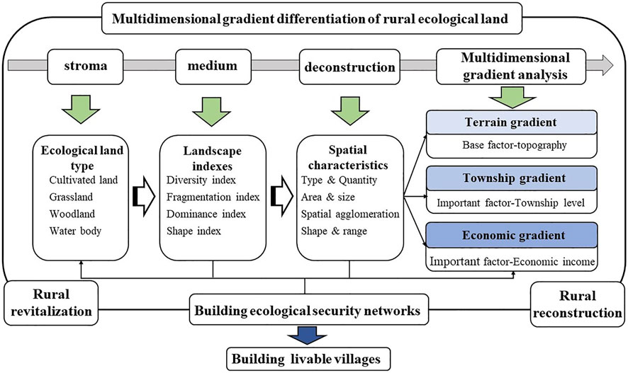
FIGURE 2. The research framework of REL.
2.3.3.1 Spatial Characteristic Index of Ecological Land
2.3.3.1.1 Diversity Index
Using the Gibbs-Martin diversity index (Zhang et al., 2018) to analyze the spatial diversity of EL, the formula is
where
2.3.3.1.2 Fragmentation Iindex
The fragmentation index (Chen and Fu, 1996) is often interpreted as the fragmentation degree of the landscape segmentation in landscape ecology. In this study, the total number of EL patches per unit area is used to reflect the fragmentation degree of REL patches. The formula is as follows:
where C is the fragmentation degree of EL.
2.3.3.1.3 Dominance Index
The dominance index (Zhou and Guo, 2003) is the degree of centralization of the dominant land use in REL. The formula is
where D is the ecological dominance degree.
2.3.3.1.4 Shape Index
The landscape shape index (Chen et al., 2017; Li et al., 2021) is often used to reflect the regularity of patches. We calculated the degree of deviation between the shape of REL and the circle (square) of the same area to show the complexity of the spatial form of REL. The formula is
where LSI is the landscape shape index.
2.3.3.2 Analysis of Hot and Cold Spots
The hot spot method was used to identify the spatial distribution position of the similar value aggregation area of the EL spatial characteristic index in Longxi County to make up for the lack of the global spatial autocorrelation and ArcGIS natural breakpoint method in the analysis of the spatial distribution relationship characteristics.
3 Result Analysis
3.1 Overall Characteristics of Rural Ecological Land
In 2020, the total area of REL in Longxi County will be 2,177.24 km2, accounting for 90.45% of the total area. Among them, the cultivated land area is the largest, reaching 1,497.62 km2, accounting for 68.79% of the REL. The grassland area is 363.24 km2, accounting for 16.68% of the REL. The woodland area is 309.61 km2, accounting for 14.22% of the REL. The water body area is the smallest, 6.76 km2, only accounting for 0.31% of the REL. The EL in Longxi County is mainly cultivated land and forest land. The cultivated land is evenly distributed in the county area (except the central urban area). The forest, grassland, and water bodies are mostly distributed along the Weihe River and in the valley.
In the township distribution of REL, there are significant differences in the distribution of different EL types in each township (Figure 3). Cultivated land is the EL type that accounts for the largest proportion of each township. The cultivated land of Wenfeng Town, Caizi Town, and Tonganyi Town accounted for more than 40% cultivated land of the county. The cultivated land of Gongchang Town, where the county government is located, accounts for a relatively small proportion of the county’s cultivated land, accounting for only 4.14%. The proportion of forest land is second, Tong’anyi Town’s forest land accounts for the highest proportion of the county’s forest land, accounting for 10.23%, and Shuangquan Town’s forest land accounts for the lowest proportion of the county’s forest land, only 2.74%. The proportion of grassland is relatively low. The proportion of grassland in Fuxing Town is the highest in the county, accounting for 17.81%. The proportion of grassland in Biyan Town is the lowest, only 1.54%. The proportion of water bodies in the county is the smallest. The water body in Tong’anyi Town accounts for the most significant proportion of water bodies in the county, accounting for 16.57%. The water bodies of Shouyang Town and Wenfeng Town along the Weihe River account for the following highest proportion of the county’s water body, accounting for 15.09% and 14.94%, respectively. In general, Tong’anyi Town takes significant advantages in cultivated land and forest land. Grassland and water resources are poor. Fuxing Town has the largest grassland area. Water bodies are less distributed in the county.
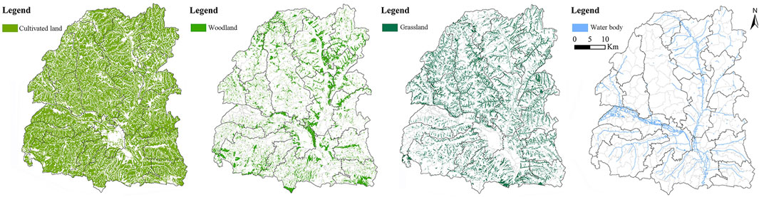
FIGURE 3. Spatial distribution map of REL.
3.2 Spatial Characteristics of Rural Ecological Land
3.2.1 Spatial Pattern Characteristics of Rural Ecological Land
We calculated the diversity index, fragmentation index, dominance index, and shape index of REL in 213 administrative villages and divided them into five categories, lowest, low, medium, high, and highest through the natural breakpoint method in ArcGIS. (Figure 4).
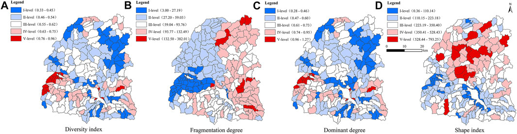
FIGURE 4. landscape index distribution map of REL.
The REL diversity index is between 0.33–0.96 (Figure 4A), with an average value of 0.57. The REL diversity indexes of 97 administrative villages are greater than the average value, accounting for 45.54% of the total administrative villages. The diversity of REL is mainly low and medium, including 54 and 67 administrative villages, accounting for 25.35 and 31.46% of the total administrative villages, respectively. Only 15 administrative villages have the highest diversity index, accounting for 7.04% of the total administrative villages. This shows that there are fewer types of EL in the administrative villages of Longxi County, and the degree of diversity is low. The areas with high and highest values of diversity index are mainly distributed in the south of the Weihe River. The lowest value areas are mainly distributed along the Weihe River and the arid mountainous areas in the north. The low and median areas show a continuous staggered distribution. The central region belongs to the valley terrain, with a high density of population settlements and more diverse types of EL use. Therefore, the high-value area of the diversity index is mainly distributed in the central region.
The REL fragmentation index is between 3.00 and 382.01 (Figure 4B), with an average value of 72.15. There are 101 administrative villages with a REL fragmentation index greater than the average value, accounting for 43.72% of the total administrative villages. The fragmentation degree of REL is mainly low and high, including 67 and 60 administrative villages, accounting for 31.46 and 28.17% of the total number of administrative villages, respectively. The number of administrative villages with the highest value is relatively small, only 11, accounting for 5.16% of the total number of administrative villages. There are significant differences in the spatial distribution of REL fragmentation, showing an outward expansion centered on the seat of the county government. The county seat and the east of G30 Lianhuo Expressway are mainly high level, with a relatively high degree of fragmentation. The northwest of the county to the west of the G30 Lianhuo Expressway and the northwest of the Weihe River is dominated by low values, and the degree of fragmentation is relatively low. The inlet of the Weihe River is dominated by the lowest value, and the south is dominated by medium value. The central area is a river valley with a good ecological environment, and the western area is less disturbed by traffic. Therefore, the fragmentation index of EL in the central and western areas is relatively low.
The REL dominance index is between 0.28 and 1.27 (Figure 4C), with an average of 0.62. The dominance index of REL for 100 administrative villages is greater than the average value, accounting for 46.95% of the total administrative villages. The dominance index of REL for 126 administrative villages is mainly low and medium value, accounting for 59.15% of the total number of administrative villages. The highest value is only 12, accounting for 5.63% of the total number of administrative villages. The dominance index of the central river valleys and the southern hills and mountains is high. The dominance index of the northern mountainous areas is mainly at the lowest and middle levels. This indicates that the concentration of REL in the central and southern regions is greater than that in the northern mountains. The central part is the river valley, the terrain is relatively flat, and the utilization rate of EL is high.
The REL shape index is between 0.36 and 793.25 (Figure 4D), with an average value of 261.92. The shape indexes of REL of 93 administrative villages are greater than the average value, accounting for 43.66% of the total administrative villages. The shape index of REL is mainly of low and medium value, including 63 and 68 administrative villages, accounting for 29.58 and 31.92% of the total number of administrative villages, respectively. There are only 36 administrative villages at a high level, accounting for 16.90% of the total number of administrative villages. The shape indexes of most of the northern and central regions are significantly greater than that of the southern region. The highest value areas are mainly concentrated in Dexing Township, Fuxing Town, Tonganyi Town, Quanjiawan Town, and Caizi Town. This indicates that the spatial shape of EL patches in the northern and central regions is complex. The northern and central regions belong to the loess hilly and gully region, and the shape of the EL with the ravines vertical and horizontal is more complex and diverse than the topography of the southern river valleys. The northern and central areas belong to the loess hilly and gully area, with the vertical and horizontal gully. The shape of EL is more complex and diverse than that of the southern river valley.
3.2.2 Analysis of Hot (Cold) Spots of Rural Ecological Land
We further analyzed hot spots and cold spots in different spaces of REL through the spatial hot spot detection method. In addition, we tested whether there are statistically significant higher- and lower-value areas. The red area in Figure 5 is the hot spot area, which represents the high-value clusters of the REL diversity index, fragmentation index, dominance index, and shape index. The blue area is cold spots, representing the lower-value areas of the REL diversity index, fragmentation index, dominance index, and shape index. The hot spots and cold spots of different characteristics of REL have significant regional differentiation. The diversity index showed a “hot spot” area in Shouyang Town and Biyan Town at the entrance of the Weihe River, and the “cold spot” area was scattered. On the contrary, the fragmentation index has formed a larger cold spot in Kezhai Town, Shouyang Town, Biyan Town, and Shuangquan Town, where the Wei River flows. Some towns in the north and east of the county have formed four small hot spots. The distribution of hot spots and cold spots in the dominance index is similar to the diversity index, and the area has increased. The shape index forms a large-scale of hot spots in Dexing Township, Fuxing Town, Yuntian Town, Quanjiawan Town, and Tonganyi Town in the central part of the county. Two larger cold spots are formed in Shouyang Town, Biyan Town, Wenfeng Town, and the periphery of the county where the Wei River flows.
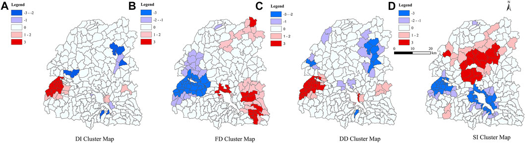
FIGURE 5. analysis of hot spots and cold spots of the landscape index of REL.
3.3 Multi-Dimensional Gradient Differentiation of Rural Ecological Land
3.3.1 Topographic Gradient Differentiation of Rural Ecological Land
The spatial pattern index of rural ecological land use in different topographic gradients is quite different (Figure 6). As the topographic gradient rises, the diversity index and dominance index first decrease and then increase, and the fragmentation index and shape index constantly increase. The average values of the diversity index in low, medium, and high topographic gradients are 0.66, 0.55, and 0.56, respectively. The average values of the fragmentation index are 78.04, 79.73, and 61.23, respectively. The average values of the dominance index are 0.76, 0.59, and 0.62, respectively. The average values of the shape index are 108.67, 260.04, and 309.27, respectively. In the lower-value area of the topographic gradient, the diversity index, fragmentation index, and dominance index fluctuate more significantly with the increase of the topographic level index. In addition, the fluctuation range is large, and the shape index shows a steady rise. The fluctuation trends of the diversity index and the dominance index are similar, and the fragmentation index is the opposite—the greater the diversity index and dominance index, the smaller the fragmentation index. In addition, when the topographic index is between 41 and 50, the diversity and dominance indexes show a sharply downward trend. The shape index and fragmentation index increase slowly. In the median area of the topographic gradient, the diversity index, fragmentation index, and dominance index show a slow rise in fluctuation with the increase of the topographic level index, but it was not significant. The shape index increases rapidly when the topographic position index is between 81 and 130 and then decreases. The fluctuation trends of the diversity index and the dominance index are also similar, and the fragmentation index is the opposite. In the higher-value area of the topographic gradient, the diversity index, fragmentation index, dominance index, and shape index generally show a trend of fluctuation and decline as the topographic level index increases. The diversity index and dominance index increased slightly when the topographic index was between 133 and 150 as well as 171–190 and then decreased rapidly.
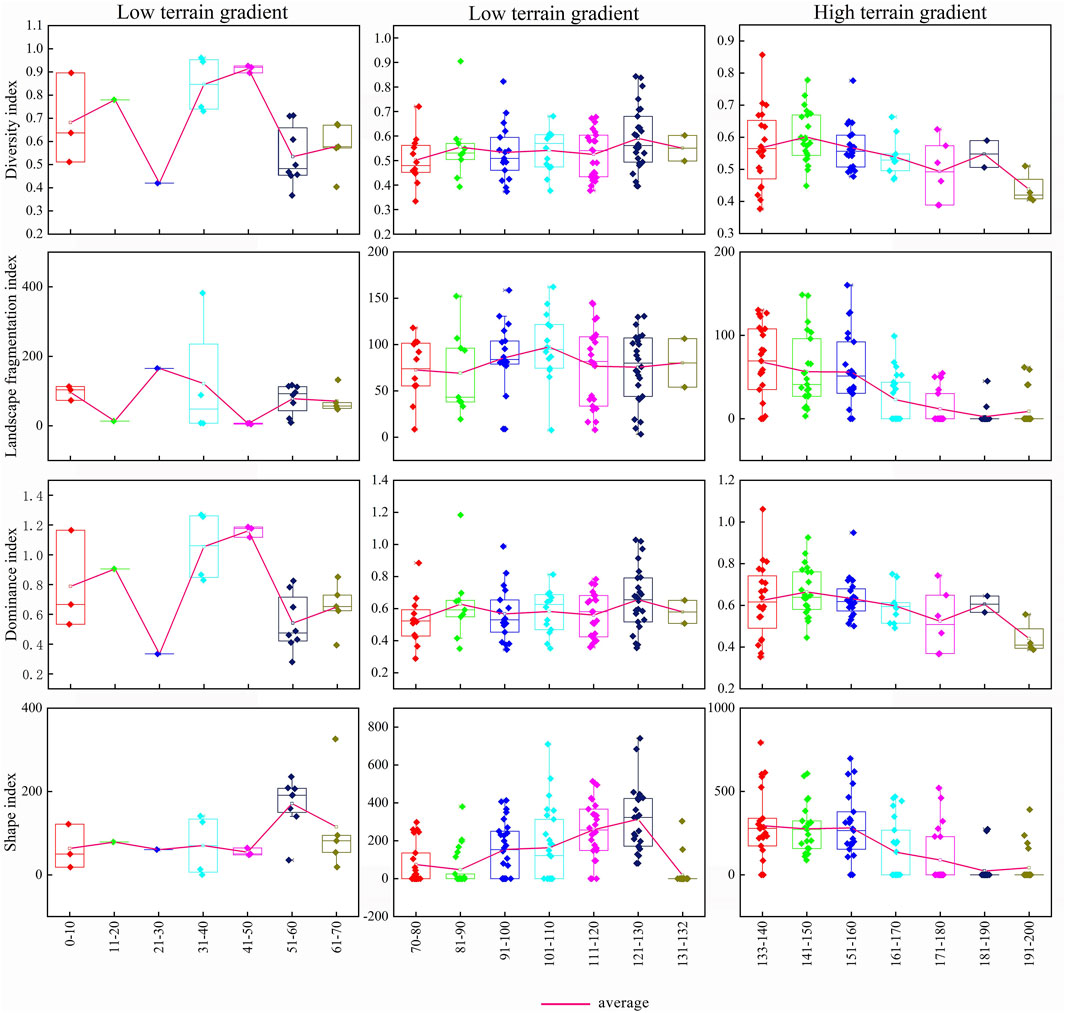
FIGURE 6. Topographic gradient differentiation map of the landscape index of REL.
3.3.2 Township Gradient Differences in Rural Ecological Land
The spatial differentiation characteristics of REL differ significantly in different township gradients (Figure 7). As the township level rises, the diversity index and dominance index increase accordingly. The fragmentation index and shape index present a normal distribution, which is relatively high in the central town. The average values of the diversity index in the general town, central town, and key town are 0.55, 0.56, and 0.60, respectively. The average values of the fragmentation index in them are 72.42, 88.69, and 64.65, respectively. The average values of the dominance index in them are 0.59, 0.61, and 0.68, respectively. The average values of the shape index in them are 308.79, 348.59, and 140.64, respectively. For the general town, the diversity index, fragmentation index, and dominance index show regular fluctuations as the distance from the township government increases. Both the diversity index and the dominance index decrease first and then increase, while the change of the fragmentation index is just the opposite. The shape index shows a steady rise. At a distance of 6–7 km, the diversity index, fragmentation index, dominance index, and shape index all show an increasing trend. In the central town, the diversity index and dominance index show a clear upward trend with increasing distance from the township government. However, the law of change is opposite to that of general town, all of which increase rapidly and then decrease. The change in the fragmentation index is the opposite. The shape index is still showing a steady upward trend. Taking 3–4 km as the boundary, the fluctuation range of the diversity index, fragmentation index, and dominance index show a trend of “large first and then small.” The growth rate of the shape index starts to slow down at 4–5 km. In the key town, the diversity index and dominance index show a significant fluctuation and decreasing trend as the distance from the township government increases. The fragmentation index and shape index show an increasing trend, and the shape index increases significantly.
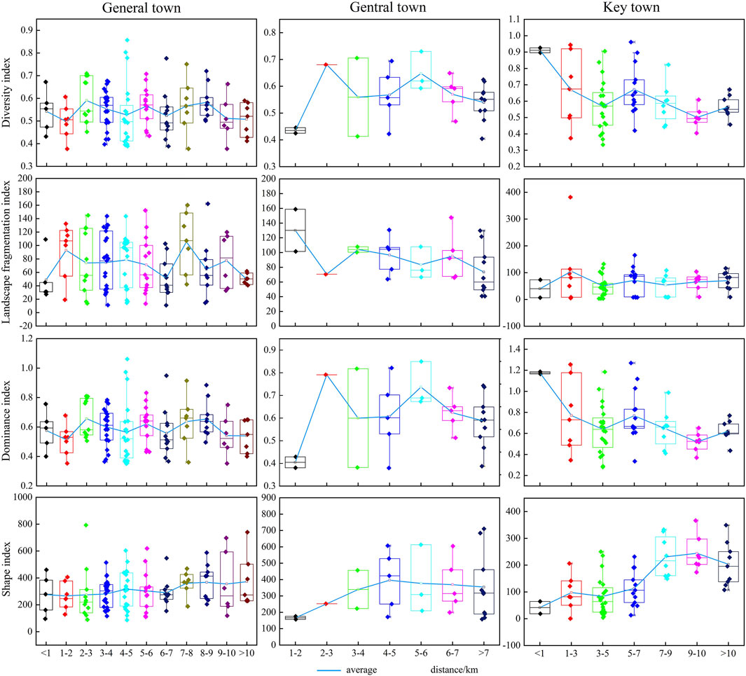
FIGURE 7. Township gradient differentiation of the landscape index of REL.
3.3.3 Economic Gradient Differences in Rural Ecological Land
The spatial pattern index of REL under different economic gradients is quite different (Figure 8). Overall, as the economic gradient increases, the diversity index and dominance index show a slow increase in the average value of the index. The fragmentation index and shape index show a trend of rapid decline at first and then gradually flattening. The average values of the diversity index in low, medium, and high economic gradients are 0.54, 0.56, and 0.59, respectively. The average values of the fragmentation index in them are 79.15, 73.09, and 63.18, respectively. The average values of the dominance index in them are 0.59, 0.61, and 0.66, respectively. The average values of the shape index in them are 307.26, 290.02, and 180.20, respectively. On low economic gradients, although the four types of indexes fluctuate, their amplitudes are relatively small. The diversity index and dominance index rose slowly, while the fragmentation index and shape index declined slowly. In the middle economic gradient, the fluctuation range of the four types of indexes increased significantly. The turning point is when the per capita annual net income of farmers reaches 7,000–7,500 yuan. The diversity index and dominance index showed a trend of first decreasing and then increasing. The fragmentation index and shape index showed a trend of first increasing and then decreasing. With respect to high economic gradients, the four types of indexes have smaller fluctuations amplitude than the medium economic gradients, and the fluctuation trend is the same as that of the low economic gradients. The diversity index and dominance index maintained a relatively high level of fluctuation. At the same time, the fragmentation index and the shape index are the opposite. In general, with the increase of the economic gradient, the types of EL used for human development and utilization are more abundant, and the shape of EL is more regular and orderly. Therefore, the diversity index and shape index generally show an increasing trend. In low economic gradient areas, EL is less affected by external factors, and the spatial characteristics do not change significantly. When the economic gradient reaches a certain level, the fragmentation of EL gradually decreases under certain development and planning. However, the dominant type is weakened. However, when developed to a certain extent, the drawbacks of ecological land development and utilization gradually appeared because of the instability of the rural economy. The degree of fragmentation and concentration increased and stabilized.
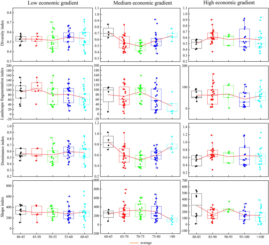
FIGURE 8. Economic gradient differentiation of the landscape index of REL.
4 Discussion
4.1 Gradient Differentiation Mechanism of Rural Ecological Land
With the industrialization and urbanization of China, the spatial distribution of rural land use has undergone tremendous changes and reconstruction. Accurately grasping the spatial differentiation characteristics of EL in different dimensions is the key to ecological, environmental protection, and the base of governance and optimization of land space (Han et al., 2021). The spatial distribution of REL results from the combined effects of multiple factors. It is closely related to the geographical topography, climatic conditions, economic development level, customs, culture, policy control, and other factors (Li et al., 2020b). It has a vital impact on all aspects of the rural ecosystem. Topography is the fundamental driving factor that affects the structure of REL, which will impact the type, scale, and form of the land. The location of towns and their resource endowments determines the rank of towns, and it is an accelerating factor for changes in the structure of REL. Different levels of cities and towns have different effects on REL. As a driving factor of the internal rural land use structure, the level of rural economic development is closely related to the rural industrial structure and land use types. There is a complex interaction mechanism between the two.
(1) The EL characteristic index varies significantly by changing the topographic gradient level. With the rise of the topographic gradient, the diversity index and fragmentation index of EL decreased overall, while the dominance index and shape complexity increased significantly. In the river valley areas with little difference in altitude and slope, and a small topographic index, there are no prominent regular characteristics in the type of REL, the degree of fragmentation of patches, the degree of land concentration, and the complexity of spatial forms. Its spatial difference depends more on its location and the concentration of human activities. In hilly and mountainous areas where the altitude and slope have increased to a certain extent, and the topographic index is relatively large, the types of REL have increased significantly—the degree of fragmentation of patches and the degree of centralization of land use increase accordingly. The complexity of the spatial form has also significantly increased. In mountainous areas with high altitudes and slopes and greater topographic index, the topography conditions become relatively complex. The availability of REL has been significantly reduced. The type of land used tends to be single, mostly grassland and woodland, and the patches are well concentrated and contiguous, and the plots are relatively regular.
(2) The EL characteristic index varies significantly by the changes in the township gradient level. With the rise of the township gradient, ecological land’s diversity index and dominance index generally increased, while the fragmentation and shape complexity first increased and then decreased. Due to various factors such as poor soil and a backward economy, the overall geographical environment of general towns is poor. Except for the government seat, most are located in mountainous and hilly areas as the distance from the township government increases, the type of REL, the degree of fragmentation of patches, the degree of concentration of land use, and the degree of complexity of spatial form have no significant change characteristics (Ma et al., 2021a). The overall change range is small, and the influence of the township government is not significant. The township government significantly affects the EL within 3 km outside the central town. The topography in this area is relatively flat, the cultivated land is relatively concentrated, and the degree of concentration is good. As the distance from the township government increases, the types of REL tend to be diversified. However, due to the division of rivers, roads, settlements, and other elements, the land is relatively irregular, and the impact of the township government is not significant beyond 3 km of EL. The key towns are mainly distributed in the river valley areas along the Weihe River. Gongchang Town, Wenfeng Town, and Shouyang Town are arranged along the river, and the layout of EL is greatly affected by the river. The types of EL within 1 km of the periphery of the river are relatively diverse, and the degree of concentration is good. The land patches are concentrated and contiguous, and the degree of fragmentation is low and relatively regular. As the distance from the township government station and the river increases, the types of REL, the degree of centralization of patches were significantly reduced, the degree of fragmentation of patches was increased, and the degree of shape complexity was significantly enhanced.
(3) The EL characteristic index of Longxi County varies greatly due to the changes in economic gradient levels. With the rise of the economic gradient, the diversity index and dominance index of EL generally increased, and the fragmentation and shape complexity showed a downward trend. Villages with low economic gradients are mostly located in mountainous areas, strongly restricted by topography, with poor agricultural production conditions and fragile ecological environments. In addition, they are far away from urban areas and townships, making industrial development difficult, and the number of migrant workers is enormous. The type of land used tends to be single and fragmented. The degree of fragmentation is small, and the patches are relatively regular. The distribution of villages in the middle economic gradient is relatively concentrated, mostly located in hilly areas, with relatively good agricultural production conditions, and are4 close to towns and villages. The types of EL have increased significantly. The land used for agriculture, forestry, water, and the grass is staggered, and the patches of EL tend to be fragmented, centralized, and complex in shape. Most of the villages in the high economic gradient area are located along the Weihe River and the main roads, which are close to the urban area and township area, and the transportation is convenient. The more diverse the use types of EL, the higher the concentration of the dominant EL, and the simpler the shape accordingly.
4.2 Suggestions on the Guarantee Policy of Rural Ecological Land
REL directly provides the ecological service guarantee for various production and living activities in rural areas. It is an essential ecological source for absorbing urban life pollution and industrial pollution (Fei et al., 2020). Therefore, scientifically protecting and making good use of REL is an essential foundation for the overall sustainable development of rural society and economy and an essential means to supplement and improve urban functions (Zhou et al., 2016; An, 2018). REL should be classified, optimized, protected, and used based on full consideration of its topographic gradient, township gradient, and economic gradient. First, correctly handle the relationship between man and nature, the relationship between production and ecology, and the relationship between ecology and people’s livelihood, scientifically plan the spatial layout of bare, auxiliary, and preservation EL and non-ecological land, and combine the gradient differences of EL in each village. Formulate EL layout and ecological protection goals in different regions, effectively protect the ecological environment and ecological space on which human beings depend, and promote sustainable economic and social development (Qiu et al., 2022). Second, it is necessary to build a county-level ecological security pattern, optimize the county-level grain production and land use pattern, and coordinate the contradiction between regional product development and ecological protection. At the same time, it is actively carrying out the consolidation of agricultural land, tapping the potential of unused land, cultivating or restoring green according to local conditions, increasing the rural ecological space, and improving the rural living environment (Gao, 2017; Yang et al., 2017). Finally, from the perspective of the gradient heterogeneity of EL, we insist on implementing policies based on local conditions and implementing differentiated REL optimization and protection paths (Zhang and Ren, 2016; Zhao et al., 2020).
4.3 Prospects for the Future Research on Rural Ecological Land
REL is an important part of territorial space, and it is of great significance for maintaining regional ecological balance and promoting sustainable urban–rural relations. At present, REL has become a hot field of academic research. Existing studies have analyzed the changes and differentiation trends of EL patterns on a long-term scale. Also, they have studied the effectiveness of different ecological spaces on a time scale. Based on the gradient of “important ecological space-surrounding area space,” the gradient difference of the protection effect is analyzed. It is concluded that the protective effect of EL in important ecological spaces is better than that of surrounding external areas (Gao et al., 2021). With the development of urbanization, the relationship between urban and rural areas has entered a critical period of strategic transformation. The development and evolution of regional humanities, nature, society, and other factors will inevitably drive the evolution of the spatial pattern of REL. However, at present, there are few studies on the spatial differentiation and impact mechanism of REL under different gradients from the multi-dimensional gradient of nature, society, and economy. Therefore, this study used the landscape index to explore the differentiation characteristics of the spatial pattern of REL in different dimensions. This not only reflects the spatial pattern characteristics of REL but also reveals the differentiation law of REL under multi-dimensional gradient. This study is of great scientific significance for the adjustment of rural land use structure, the promotion of urban–rural integration construction, the delimitation of regional ecological protection red line (Guan et al., 2018), and the improvement of the ecosystem service function. However, due to the availability of data and the constraints of research perspectives, this study has many uncertainties and limitations. First, according to the traditional land use classification system, this study classifies EL into four categories: woodland, grassland, water body, and cultivated land, without considering the ecological attributes and ecological functions of each land use (Li et al., 2020b). Second, this study attempts to study the spatial differentiation characteristics of REL from a multi-dimensional gradient. This study considers the impacts and differences of multiple factors such as topographical conditions, township development level, and socio-economic conditions on the spatial distribution of REL. However, the interaction of multiple factors on the spatial distribution of EL is not considered (Feng et al., 2021b). In addition, the spatial distribution of REL under different gradients obtained in this study does not mean that the distribution of REL in other areas follows this result. Research on EL in different regions should consider its regional characteristics, local conditions, and socio-economic situations (Ma et al., 2021a).
Ecological civilization has become a national strategy for the construction of a socialist society with Chinese characteristics (Fei et al., 2020). The new situation requires us to accurately identify the spatial differentiation characteristics of REL so as to optimize the reconstruction of rural ecological space, improve the scientific control of rural ecological space, and promote the construction of an ecological safety network (Long et al., 2015; Wen et al., 2017). In the follow-up EL research, we will strengthen the planning and control strategy analysis of EL and the evaluation and analysis of the implementation of institutional mechanisms so that the research results of EL will help to play better a guiding role (Chen et al., 2008; Qi et al., 2016).
5 Conclusion
The number of REL in Longxi County is relatively large, and the spatial pattern is significantly different. The area of EL accounts for 90.45% of the county’s total area. It has an excellent ecological background and is dominated by cultivated land, accounting for 68.79% of the REL. Grassland is second, accounting for 16.68% of REL. The area of water bodies is the least, accounting for only 0.31% of the REL. EL is one of the important types of land use. Accurately grasping the spatial distribution and scale of different types of EL is of great significance for accurately protecting EL and using EL according to local conditions. In the future, Longxi County should focus on protecting the main ecological resource of Cultivated land while taking into account the protection of grassland, forest land, and water bodies.
Second, the spatial characteristic index and spatial pattern of REL in Longxi County are significantly different. The diversity, dominance, and shape index are mainly at low and medium levels, while the fragmentation degree is mainly at low and high levels. In the protection and utilization of EL, we should increase the protection of different types of EL and improve the effectiveness of protection measures according to the spatial characteristics of different types of EL.
The diversity, dominance, fragmentation, and shape index gradients of REL in Longxi County were significantly different. With the increase of the topographic position index, the types of REL increased significantly, the fragmentation degree of patches and the degree of concentration of land use increased, and the complexity of the spatial form also increased significantly. After the local topographic position index reaches a certain level, the availability of REL is significantly reduced. The type of land use tends to be single, the concentration of patches is poor, and the shape of the plot is relatively complex. In addition, REL is also affected by the township level. The higher the level, the more significant the impact, but smaller the impact range. REL of the general township is not significantly affected by the township government, but the township government within 3 km outside the central town is affected significantly. Within 1 km of the key township are significantly affected by the township government. The impact of the economic gradient on REL is closely related to the geographical environment where the village is located. With the rise of the economic gradient, the geographical environment becomes better, the types of land use gradually increase, and the degree of concentration increases, but the fragmentation and morphology show the trend of rising and then falling. Under the division of different gradients, the characteristic indices of EL have different evolution laws. Studying the spatial characteristics of EL from multiple dimensions is conducive to a comprehensive understanding of the internal trends and mechanisms of EL distribution and plays a vital role in national land spatial planning and national land ecological security protection. The protection of REL in Longxi County should fully consider the topography, townships, and economic gradients where it is located, integrate the spatial differentiation characteristics of the diversity, fragmentation, dominance, and shape indexes, and take protection measures according to local conditions. From the aspects of formulating ecological protection goals in different regions, constructing county ecological security patterns, and coordinating the contradiction between regional product development and ecological protection, it proposes differentiated paths for REL optimization and protection to optimize the spatial development pattern of the country and promote the construction of a rural living environment that is livable and suitable for business.
Data Availability Statement
The raw data supporting the conclusion of this article will be made available by the authors, without undue reservation.
Author Contributions
LM and YY designed the study and processed the data and gave comments and suggestions on the manuscript. All authors contributed to the results, related discussions, and manuscript writing.
Funding
This research was funded by the National Natural Science Foundation of China, grant number 41961033, and the National Natural Science Foundation of Gansu Province, grant number 20JR5RA519.
Conflict of Interest
The authors declare that the research was conducted in the absence of any commercial or financial relationships that could be construed as a potential conflict of interest.
Publisher’s Note
All claims expressed in this article are solely those of the authors and do not necessarily represent those of their affiliated organizations, or those of the publisher, the editors, and the reviewers. Any product that may be evaluated in this article, or claim that may be made by its manufacturer, is not guaranteed or endorsed by the publisher.
References
An, G. (2018). Spatio-temporal Evolution and Conservation Zoning of Ecological Land in Shandong Province Based on EKC & Lorenz Curve. China Land Sci. 32, 89–96.
Capotorti, G., Guida, D., Siervo, V., Smiraglia, D., and Blasi, C. (2012). Ecological Classification of Land and Conservation of Biodiversity at the National Level: The Case of Italy. Biol. Conserv. 147, 174–183. doi:10.1016/j.biocon.2011.12.028
Chen, L., and Fu, B. (1996). Analysis of Impact of Human Activity on Landscape Structure in Yellow River Delta—A Case Study of Dongying Region. Acta Ecol. Sin. 16, 337–344.
Chen, S., Liu, Y., and Peng, L. (2008). Dynamics of Urban Ecological Space Evolution and Policy Responses: A Case Study of Nanjing City. Acta Ecol. Sin. 28, 2270–2278. doi:10.3321/j.issn:1000-0933.2008.05.044
Chen, W., Liu, Y., Yin, C., Jing, Y., and Guan, X. K. (2017). Layout Optimization for Rural Settlements Based on Iterative Evaluation Method and its Remediation Strategies. Trans. Chin. Soc. Agric. Eng. 33, 255–263. doi:10.11975/j.issn.1002-6819.2017.17.034
Colding, J. (2007). 'Ecological Land Use Complementation' for Building Resilience in Urban Ecosystems. Landsc. Urban Plan. 81, 46–55. doi:10.1016/j.landurbplan.2006.10.016
Deng, H., Chen, C., Liu, X., and Wu, G. (2009). Conception and Function Classification of Regional Ecological Land. Acta Ecol. Sin. 29, 1519–1524.
Fei, J., Xia, J., Ou, D., Shu, X., and Hu, J. (2020). Integrated Identification and Classification of Rural Ecological Land. Chin. J. Ecol. 39, 1045–1055. doi:10.13292/j.1000-4890.202003.031
Feng, R., Wang, F., and Wang, K. (2021). Spatial-temporal Patterns and Influencing Factors of Ecological Land Degradation-Restoration in Guangdong-Hong Kong-Macao Greater Bay Area. Sci. Total Environ. 794, 148671. doi:10.1016/j.scitotenv.2021.148671
Feng, R., Wang, F., Wang, K., Wang, H., and Li, L. (2021). Urban Ecological Land and Natural-Anthropogenic Environment Interactively Drive Surface Urban Heat Island: An Urban Agglomeration-Level Study in China. Environ. Int. 157, 106857. doi:10.1016/j.envint.2021.106857
Folke, C., Carpenter, S., Walker, B., Scheffer, M., Elmqvist, T., Gunderson, L., et al. (2004). Regime Shifts, Resilience, and Biodiversity in Ecosystem Management. Annu. Rev. Ecol. Evol. Syst. 35, 557–581. doi:10.1146/annurev.ecolsys.35.021103.105711
Frondoni, R., Mollo, B., and Capotorti, G. (2011). A Landscape Analysis of Land Cover Change in the Municipality of Rome (Italy): Spatio-Temporal Characteristics and Ecological Implications of Land Cover Transitions from 1954 to 2001. Landsc. Urban Plan. 100, 117–128. doi:10.1016/j.landurbplan.2010.12.002
Gao, J., Liu, X., Wang, C., Wang, Y., Fu, Z., Hou, P., et al. (2021). Evaluating Changes in Ecological Land and Effect of Protecting Important Ecological Spaces in China. Acta Geogr. Sin. 76, 1708–1721. doi:10.1007/s11442-021-1896-y
Gao, Y. (2017). Strengthen Research on Ecological Space Protection and Use Control. China Land 12, 16–18.
Gb/T 21010-2017, (2017). Current Land Use Classification. China: standardization administration, State Administration for Market Regulation.
Gong, J., Gao, Y., Zhang, L., Xie, Y., Zhao, C., and Qian, D. (2014). Distribution Characteristics of Ecological Risks in Land Use Based on Terrain Gradient and Landscape Structure: Taking Bailongjiang Watershed as an Example. J. Lanzhou Univ. Nat. Sci. 50, 692–698. doi:10.13885/j.issn.0455-2059.2014.05.019
Gong, J., Jiang, C., Chen, W., Chen, X., and Liu, Y. (2018). Spatiotemporal Dynamics in the Cultivated and Built-Up Land of Guangzhou: Insights from Zoning. Habitat Int. 82, 104–112. doi:10.1016/j.habitatint.2018.10.004
Gonzalez-Abraham, C. E., Radeloff, V. C., Hawbaker, T. J., Hammer, R. B., Stewart, S. I., and Clayton, M. K. (2007). Patterns of Houses and Habitat Loss from 1937 to 1999 in Northern Wisconsin, USA. Ecol. Appl. 17, 2011–2023. doi:10.1890/06-1963.1
Guan, Q., Hao, J., Shi, X., Gao, Y., Wang, H., and Li, M. (2018). Study on the Changes of Ecological Land and Ecosystem Service Value in China. J. Nat. Resour. 33, 195–207. doi:10.11849/zrzyxb.20161400
Han, M., Kong, X., Li, Y., Wei, F., Kong, F., and Huang, S. (2021). Eco-environmental Effects and its Spatial Heterogeneity of Ecological-Production-Living’ Land Use Transformation in the Yellow River Delta. Sci. Geogr. Sin. 41, 1009–1018. doi:10.13249/j.cnki.sgs.2021.06.010
Hietala-Koivu, R. (1999). Agricultural Landscape Change: a Case Study in Yläne, Southwest Finland. Landsc. Urban Plan. 46, 103–108. doi:10.1016/s0169-2046(99)00051-1
Joppa, L. N., and Pfaff, A. (2011). Global Protected Area Impacts. Proc. R. Soc. B 278, 1633–1638. doi:10.1098/rspb.2010.1713
Li, H., Yi, N., Yao, W., Wang, S., Li, Z., and Yang, S. (2011). Shangri-La County Ecological Land Use Planning Based on Landscape Security Pattern. Acta Ecol. Sin. 31, 5928–5936. doi:10.1016/j.chnaes.2010.11.006
Li, M., Tian, F., and Dong, Y. (2016). Space Identification of Ecological Importance and Protection on Urban Ecological Land in Yanji-Longjing-Tumen Area. Sci. Geogr. Sin. 36, 1870–1876. doi:10.13249/j.cnki.sgs.2016.12.012
Li, D., Xu, E., and Zhang, H. (2020). Influence of Ecological Land Change on Wind Erosion Prevention Service in Arid Area of Northwest China from 1990 to 2015. Ecol. Indic. 117, 106686. doi:10.1016/j.ecolind.2020.106686
Li, G., Jiang, C., Du, J., Jia, Y., and Bai, J. (2020). Spatial Differentiation Characteristics of Internal Ecological Land Structure in Rural Settlements and its Response to Natural and Socio-Economic Conditions in the Central Plains, China. Sci. Total Environ. 709, 135932. doi:10.1016/j.scitotenv.2019.135932
Li, J., Zhang, P., and Guo, M. (2021). Spatial Distribution and Optimized Reconstructing Mode of Rural Settlement at the Village Scale of Jilin Province. Sci. Geogr. Sin. 41, 842–850. doi:10.13249/j.cnki.sgs.2021.05.012
Liu, L., Lei, D., Ran, Y., and Zhang, Y. (2021). Identification of Critical Ecological Land in Dianchi Watershed Based on the Perspective of Ecosystem Service Function. Trans. Chin. Soc. Agric. Eng. 37, 277–284. doi:10.11975/j.issn.1002-6819.2021.11.031
Liu, Y., Liu, Y., and Guo, L. (2010). Spatial Difference Analysis of the Rural Residents'Net- Income along the Bohai Rim in China. Econ. Geogr. 30, 992–997.
Long, H., Liu, Y., Li, T., Wang, J., and Liu, A. (2015). A Primary Study on Ecological Land Use Classification. Ecol. Environ. Sci. 24, 1–7.
Longxi County People's Government (2020). Statistical Communiqué on Longxi County's National Economic and Social Development in 2020. Available online: http://www.cnlongxi.gov.cn/art/2021/7/5/art_10710_1427503.html/November accessed on 10, 2021).
Ma, L., Cui, X., Yao, Y., and Liu, S. (2021a). Gradient Difference of Structure of Rural Construction Land in Loess Hilly Region: A Case Study of Yuzhong County, Gansu Province, China. Land 10, 349. doi:10.3390/land10040349
Ministry of Housing and Urban-Rural Development of the People's Republic of China (2014). Circular of the Ministry of Housing and Urban-Rural Development and Other Departments on Publishing the List of National Key Towns. Available online: https://www.mohurd.gov.cn/gongkai/fdzdgknr/tzgg/201407/20140731_218612.html (accessed on November 10, 2021).
National Geomatics Center of China (2021). National Geomatics Center of China. Available online: http://www.ngcc.cn/ngcc/February accessed on 6, 2021).
Nngler, P., Glenn, E., and Hinojosa-Huerta, O. (2008). Synthesis of Ground and Remote Sensing Data for Monitoring Ecosystem Functions in the Colorado River Delta, Mexico. Remote Sens. Environ. 113, 1473–1485. doi:10.1016/j.rse.2008.06.018
Peng, L., Liu, S., and Sun, L. (2016). Spatial-temporal Changes of Rurality Driven by Urbanization and Industrialization: A Case Study of the Three Gorges Reservoir Area in Chongqing, China. Habitat Int. 51, 124–132. doi:10.1016/j.habitatint.2015.10.021
Pickett, S. T. A., Cadenasso, M. L., Grove, J. M., Nilon, C. H., Pouyat, R. V., Zipperer, W. C., et al. (2001). Urban Ecological Systems: Linking Terrestrial Ecological, Physical, and Socioeconomic Components of Metropolitan Areas. Annu. Rev. Ecol. Syst. 32, 127–157. doi:10.1146/annurev.ecolsys.32.081501.114012
Pignatti, S. (1993). Impact of Tourism on the Mountain Landscape of Central Italy. Landsc. Urban Plan. 24, 49–53. doi:10.1016/0169-2046(93)90082-o
Puskás, N., Abunnasr, Y., and Naalbandian, S. (2021). Assessing Deeper Levels of Participation in Nature-Based Solutions in Urban Landscapes – A Literature Review of Real-World Cases. Landsc. Urban Plan. 210, 104065. doi:10.1016/j.landurbplan.2021.104065
Qi, F., Li, X., and Liu, K. (2016). System Research of Natural Ecological Space Use Control. China Land 12, 21–23.
Qiao, J., and Li, X. (2008). Classification of Rural Henan Economy from the Microscopic Perspective. Econ. Geogr. 28, 832–840.
Qiu, S., Peng, J., Zheng, H., Xu, Z., and Meersmans, J. (2022). How Can Massive Ecological Restoration Programs Interplay with Social-Ecological Systems? A Review of Research in the South China Karst Region. Sci. Total Environ. 807, 150723. doi:10.1016/j.scitotenv.2021.150723
Qu, Y., Jiang, G., Zhang, B., Li, H., and Wei, S. (2017). Spatial Characteristics of Rural Residential Land Transition and its Economic Gradient Differentiation. Acta Geogr. Sin. 72, 1845–1858. doi:10.11821/dlxb201710009
Qu, L., Liu, Y., Zhou, Y., and Li, Y. (2019). Spatio-temporal Evolution of Ecologically-Sustainable Land Use in the Luoxiao Mountains and Responses of its Ecosystem Services: A Case Study of Jinggangshan City in Jiangxi Province. Acta Ecol. Sin. 39, 3468–3481. doi:10.5846/stxb201806011223
Seppelt, R., and Voinov, A. (2002). Optimization Methodology for Land Use Patterns Using Spatially Explicit Landscape Models. Ecol. Model. 151, 125–142. doi:10.1016/s0304-3800(01)00455-0
Sevenant, M., and Antrop, M. (2007). Settlement Models, Land Use and Visibility in Rural Landscapes: Two Case Studies in Greece. Landsc. Urban Plan. 80, 362–374. doi:10.1016/j.landurbplan.2006.09.004
Shi, Y., Han, R., and Guo, L. (2021). Ecosystem Service Value and Is Spatial Response to Urbanization Based on Terrain Gradient in Southern Hilly and Mountainous Region: A Case Study in Northern Guangdong, China. Acta Ecol. Sin. 41, 7238–7248. doi:10.5846/stxb202006121526
Song, W., Deng, X., Yuan, Y., Wang, Z., and Li, Z. (2015). Impacts of Land Use Change on Valued Ecosystem Service in Rapidly Urbanized North China Plain. Ecol. Model. 318, 245–253. doi:10.1016/j.ecolmodel.2015.01.029
Su, W., Yang, G., and Zhen, F. (2007). Ecological Land Fragmentation and its Connectivity with Urbanization in the Yangtze River Delta. Acta Geogr. Sin. 62, 1309–1317. doi:10.11821/xb200712007
Tóth, G., Hermann, T., Ravina da Silva, M., and Montanarella, L. (2018). Monitoring Soil for Sustainable Development and Land Degradation Neutrality. Environ. Monit. Assess. 190, 57. doi:10.1007/s10661-017-6415-3
Unccd (United Nations Convention to Combat Desertification) (2017). Global Land Outlook. Bonn, Germany: Secretariat of the United Nations Convention to Combat Desertification.
Wang, Z., and Li, R. (2006). Classification, Ecosystem Service, Protection and Utilization of the Urban Ecological Land——A Case Study of Liaocheng City. Res. Soil Water Conservation 13, 306–308. doi:10.3969/j.issn.1005-3409.2006.06.098
Wassmann, P., Duarte, C. M., Agustí, S., and Sejr, M. K. (2011). Footprints of climate change in the Arctic marine ecosystem. Glob. Change Biol. 17, 1235–1249. doi:10.1111/j.1365-2486.2010.02311.x
Wei, X., Zhang, J., Wang, S., Liu, K., Wang, N., and Liu, Y. (2021). The evolution and differentiation trend of ecological land pattern in the Yellow River Basin from 2000 to 2020. Chin. J. Ecol. 40, 3424–3435. doi:10.13292/j.1000-4890.202111.019
Wen, B., Zhu, G., Xia, M., Zhang, K., Liu, Y., and Wang, W. (2017). Ecological land classification protection is based on the landscape security pattern in Yixing City. Acta Ecol. Sin. 37, 3881–3891. doi:10.5846/stxb201603170478
Xu, C., Gong, J., Li, Y., Yan, L., and Gao, B. (2020). Spatial distribution characteristics of typical ecosystem services based on terrain gradients of BailongjiangWatershed in Gansu. Acta Ecol. Sin. 40, 4291–4301. doi:10.5846/stxb201911152447
Yang, R., and Luo, X. (2020). Progress and Prospects in Rural Space Diversification, Reconstruction, and Governance from a Development Perspective. Trop. Geogr. 40, 575–588. doi:10.13284/j.cnki.rddl.003240
Yang, T., Kuang, W., Liu, W., Liu, A., and Pan, T. (2017). Optimizing the layout of eco-spatial structure in Guanzhong urban agglomeration based on the ecological security pattern. Geogr. Res. 36, 441–452. doi:10.11821/dlyj201703004
Yao, Y., Ma, L., Che, X., and Dou, H. (2021). Simulation study of urban expansion under ecological constraint-Taking Yuzhong County, China as an example. Urban For. Urban Green. 57, 126933. doi:10.1016/j.ufug.2020.126933
Yu, F., Li, X., Zhang, L., Xu, W., Fu, R., and Wang, H. (2015). Study of ecological land in China: Conception, classification. and spatial-temporal pattern. Acta Ecol. Sin. 35, 4931–4943. doi:10.5846/stxb201311052672
Yu, K. J., Qiao, Q., Li, D. H., Yuan, H., and Wang, S. S. (2009). Ecological land use in three towns of eastern Beijing: a case study based on landscape security pattern analysis. Ying Yong Sheng Tai Xue Bao 20, 1932–1939.
Zhang, J., and Ren, Z. (2016). Spatiotemporal pattern and terrain gradient effect of land use change in Qinling-Bashan mountains. Trans. Chin. Soc. Agric. Eng. 32, 250–257. doi:10.11975/j.issn.1002-6819.2016.14.033
Zhang, T., Zhou, J., Zhang, F., Xie, Z., and Zhang, B. (2018). Research on land use evolution in rural residential areas under the background of industrialization and urbanization. J. China Agric. Univ. 23, 147–157. doi:10.11841/j.issn.1007-4333.2018.02.18
Zhao, Y., Cao, J., Zhang, X. D., and He, G. (2020). Topographic gradient effect and spatial pattern of land use in Baota District. Arid. Land Geogr. 43, 1307–1315. doi:10.12118/j.issn.1000-6060.2020.05.16
Zhou, Q., and Chen, D. (2013). Researched the Topographic Differentiation of Land Use in Chongqing Mountainous Metropolitan Area. Res. Soil Water Conservation 20, 86–91.
Zhou, T., and Guo, D. (2003). GIS-based study on the spatial structure of urban greenbelt landscapes: Taking Ningbo City as an example. Acta Ecol. Sin. 23, 901–907.
Zhou, R., Wang, X., Su, H., and Lou, Y. (2015). Identification and security pattern of ecological land in Pingdingshan newly developed area. Acta Ecol. Sin. 35, 2003–2012. doi:10.5846/stxb201305241169
Zhou, Z., Meng, J., Qi, Y., and Peng, F. (2016). Importance of ecological lands and their pattern optimization in China: A review. Chin. J. Ecol. 35, 218–225. doi:10.13292/j.1000-4890.201601.030
Zhou, X., He, Y., Huang, X., and Zhang, M. (2021). Topographic gradient effects of habitat quality and its response to land use change in Hubei Section of the Three Gorges Reservoir. Trans. Chin. Soc. Agric. Eng. 37, 259–267. doi:10.11975/j.issn.1002-6819.2021.11.029
Keywords: rural ecological land, spatial pattern, gradient differentiation, loess hilly area in China, Longxi County
Citation: Ma L, Yao Y, Tao T and Zong Y (2022) Spatial Pattern of Rural Ecological Land and Its Multidimensional Gradient Differentiation in a Loess Hilly Region: A Case Study of Longxi County, Gansu Province, China. Front. Environ. Sci. 10:900801. doi: 10.3389/fenvs.2022.900801
Received: 21 March 2022; Accepted: 18 April 2022;
Published: 26 May 2022.
Edited by:
Yongsheng Wang, Institute of Geographic Sciences and Natural Resources Research (CAS), ChinaReviewed by:
Ren Yang, Sun Yat-sen University, ChinaFang Su, Shaanxi University of Science and Technology, China
Copyright © 2022 Ma, Yao, Tao and Zong. This is an open-access article distributed under the terms of the Creative Commons Attribution License (CC BY). The use, distribution or reproduction in other forums is permitted, provided the original author(s) and the copyright owner(s) are credited and that the original publication in this journal is cited, in accordance with accepted academic practice. No use, distribution or reproduction is permitted which does not comply with these terms.
*Correspondence: Libang Ma, bWFsYjA2MTNAMTYzLmNvbQ==