 Yuqing Jian
 Yuangong Chen2
- 1Guangzhou University, Guangzhou, China
- 2Hong Kong Polytechnic University, Kowloon, Hong Kong SAR, China
- 3Guangdong Party Institute of Chinese Communist Party, Guangzhou, China
The use of spatio-temporal statistical combination method to explore the land use transition in urban suburbs provides an essential resource for promoting urban-rural integration and management of further urbanization. A combination of Space Time Cube and Geodetector methods was used to quantitatively identify the dominant morphology of land use change, and explore the recessive morphology and driving mechanism in Baiyun District, a suburb of Guangzhou from 1980 to 2020. Between these years, the land use changes were dominated by the expansion of built-up land and the shrinkage of cropland. The expansion took place in southern (1990-2000) to central (2000-2005) areas of the jurisdiction, followed by large-scale decentralization (2005-2010). Land use activities showed a downward trend. A continuous cold spot was mainly distributed in the southeast and remote areas near the urban center, whereas a continuous hot spot was spatially characterized by a multinuclear pattern, mainly concentrated in the center and south. Socioeconomic factors significantly affected the spatial pattern of land use activities. The trend turning in land use morphology of land use change can be divided into four stages: land primitivation from 1980 to 1990, land fragmentation from 1990 to 2000, land overflow from 2000 to 2010, and land intensification from 2010 to the present. Baiyun District is at the forefront of China’s development and has typical “suburban” characteristics, which can provide a reference for other suburbs in China to develop in stages. Today, urban suburbs in China face the problems of limited land resources and mixed land use space. Taking advantage of the new national strategic environment could effectively solve these land use issues in urban suburbs and achieve sustainable development. New trends in land use morphology research, also considering land use effects and land use change mechanisms in an integrated manner, are conducive to further deepening the understanding of land use transitions. Moreover, spatiotemporal statistical methods have innovated the field of mining the spatiotemporal characteristics of land use. Based on a scientific method for spatiotemporal analysis, we were able to reconstruct the three-dimensional space of land and improve the methods applied for research into land use change.
1 Introduction
Transformation refers to the process of fundamental changes in the structural form of things, their mode of operation and people’s perceptions (Asquith et al., 2018). In 1995, geographer Grainer, inspired by the Forest Transformation Hypothesis, extended the Nation-al Land Use Morphology theory to the National Land Use Transition process theory, which focuses on forestry. This theory states that most countries that have forestry as a significant component of their economy show varying degrees of change in land use morphology over time. This is caused by a range of underlying socio-economic factors that are ultimately controlled through policy measures and lead to a new equilibrium in land use morphology (Grainger, 1995a; Grainger, 1995b). As human-driven changes to the Earth’s surface generate dramatic land use change, global environmental change and socio-economic sustainability require integrated management (Turner et al., 2007). Several scholars have developed land use transition theories on the basis of Grainer’s process theory, focusing on the current land use change and major issues of land use management. For example, Long Hualou proposed the “land use morphology transition” based on the theory that land use morphology includes the dominant morphology of land use type structure and the recessive morphology, which is dependent on the dominant morphology and has multiple attributes such as quality and property rights. The land use morphology transition refers to the transition of regional land use morphology caused by each land use type transfer within a specific period of time (Long and Qu, 2018). DeFries pointed out that the transition of land use functions has gradually changed from purely natural ecology to intensive human use (DeFries et al., 2004). Lambin stated that the mechanism behind land use transition are mainly endogenous socio-ecological forces and exogenous socio-economic factors (Lambin and Meyfroid, 2010). During the period, international research on land use transition came to the following consensus: 1) the loss of cropland and the expansion of built-up land are the most typical forms of land use transition; 2) land use transition is non-linear and evolves in accordance with the socio-economic development stage of a country or region (DeFries et al., 2004; Foley et al., 2005; Lambin and Meyfroid, 2010; Long and Qu, 2018). Correspondingly, the concept of land use transition has been deepened and defined as the trend turning of land use morphology in a certain region in long-term changes under socio-economic development. This includes the trend turning of specific land use types such as cropland, forest, built-up land, rural land, and also in the overall land use morphology of the region (Song, 2017). “Trend turning” is often used in climatology, for example, when long time series are analyzed, two temporally close periods may show significantly different trends (Zuo et al., 2019). Land use transition focuses on trend turning in land use morphology, defined as the development of land use change to a certain stage, resulting in a land use morphology with a set of typical stage characteristics corresponding to a certain stage of socio-economic development (Li, 2021).
Trend turning of land use transition could improve the explanation of the various stage characteristics of the transition of dominant morphology and the analysis of the land use problems indicated by the transition of recessive morphology. This information can then be used to identify suitable response strategies for the regulation of the transition (Yang et al., 2018; Li, 2021). Internationally, scholars have focused on the trend turning of land use morphology from different perspectives, such as long time series of area change (Hailu et al., 2020); spatiotemporal pattern of a certain land type (Li et al., 2020); spatial expression of landscape features accompanying land use changes (Asabere et al., 2020), the “ecological-social-economic” benefits of land use change (Chen et al., 2021), and the factors of land phase change (Qu et al., 2020), have been studied in stages. Existing studies generally focus on the geographic patterns, processes, change rules and mechanisms, and have researched land use morphological (dominant and recessive) transition, land use functional transition, land use transition mechanisms. However, these approaches should be strengthened with tools and further methodological improvements to visualize the research findings.
In recent years, the rise of Spatiotemporal statistics has brought new ideas and methods to geographical research. Spatiotemporal statistics procedures use computers to visualize complex and abstract spatiotemporal data interactively. By reconstructing and analyzing the change process of spatial position and attribute of the geographical phenomenon over time, we can identify the specific relationships and detect anomalies. Furthermore, the mathematical model of spatiotemporal processes can be established to identify the driving factors behind geographical phenomena. Spatial correlation analysis tools such as Kriging, Moran’s I, LISA, GWR, Bayes have been widely used for these purposes (Spöck and Pilz, 2015). Therefore, with reference to spatiotemporal statistical research, this study proposed the combined application of the Space Time Cube and Geodetector methods for identifying land use morphology changes. Space Time Cube measures trends in the values of each spatial location across time, identifying emerging hot and cold spots and outliers (Esri, 2021). Geodetector is then used to detect the spatial heterogeneity of different geographical phenomena and their driving forces (Wang et al., 2010). The combined application has the potential to quickly and intuitively obtain the spatiotemporal characteristics of the dominant land use morphology and analyze the recessive land use morphology changes under the potential mechanism.
As a result of urbanization in recent decades, rural production elements in China have become concentrated towards cities, leading to considerable transformation of urban and rural boundaries (Liu and Li, 2017). In this process, the traditional rural core periphery has gradually evolved into a transitional space of urban elements based on a dualistic structure such as the urban suburbs (also known as urban fringe, edge cities and urban-rural transition zone, etc.) (Gu, 2020). Similar to the natural ecotone (Hansen et al., 1988), the suburban territorial space also has the unique heterogeneous characteristics of adjacent areas, forming a unique land use transition problem. For example, the dominant morphology of land use, such as the rapid non-agriculturalization of cropland and the disorderly expansion of built-up land (Ma et al., 2020); There are particular problems associated with land use recessive morphology, such as “village in city,” and the related issues of mixed ownership and the pollution of “production-living-ecology” space(Yao and Tian, 2020); The development problems associated with land use stage, such as resource and environmental constraints (Cao et al., 2021; Elahi et al., 2022a), the conception lag behind of natives (Elahi et al., 2022b), backward industrial technology and uncontrollable extreme weather (Elahi et al., 2021; Nath et al., 2022). The dominant morphology dominated by the land structure and the recessive morphology have gradually become projected in the suburban space (Yanbo et al., 2021). Suburbs in China have quietly undergone an irreversible and difficult land use transition. However, there has been relatively little research on the growth and characteristics of these suburban areas. For example, research is usually based on a comparative analysis of the dominant morphologies of each period in terms of both “quantity” and “spatial structure,” and research on the trend transition of land use morphology in suburban comprehensive period is currently lacking. These omissions are not conducive to revealing the transitional and phased spatial characteristics of suburban land use change and the transitional and periodic characteristics of associated land use change. Moreover, it is not easy to excavate the hybridity of its characteristics in the vertical direction. This study takes Baiyun District, Guangzhou, a suburb in a developing metropolis in China, as the study area. A three-module quantitative study of land use transition paths (Section 3.1), spatiotemporal evolution morphology (Section 3.2) and master control factors (Section 3.3) was conducted through the integrated application of the Space Time Cube and Geodetector methods. Based on these results, the trending transitional development of land use morphology in the study area was analyzed in local development history (Section 3.4). The study’s contributions are specifically addressed: 1) enrich the theories related to land use transition in suburbs, 2) couple spatio-temporal statistics and land system science through spatiotemporal pattern mining methods, 3)provide a scientific basis for strategic decisions to promote urban-rural integration.
2 Materials and Methods
2.1 Study Area
Baiyun District is located in the central and western part of Guangzhou City (Figure 1). It is in the transition zone between the low mountains of central Guangdong and the plains of the Pearl River Delta, high topography in the north and northeast and low in the west and south. It belongs to the southern subtropical monsoon climate zone, with high precipitation and temperatures occurring in the same period and an average annual temperature of 21.8 °C and annual rainfall of 1,694 mm. It contains the Baiyun Mountain Scenic Area and the Maofeng Mountain Forest Park, and is thus considered a region of Guangzhou with a good natural environment (Baiyun District Information Database in Guangzhou, 2021).
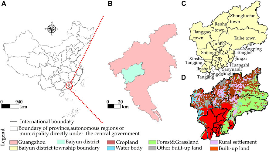
FIGURE 1. The location of Baiyun, Guangzhou (A,B), boundaries of each township (C) and spatial distribution of land use in 2020 (D).
In the 1980s, the study area was officially renamed “Baiyun District” from its original name of “Suburban District” and was included in the urban area of Guangzhou. In 2010, Baiyun District had 14 streets and four towns under its jurisdiction, making it the largest administrative district in Guangzhou’s central urban area with the largest external population (Guangzhou Statistic Bureau, 2021). The complexity and diversity of diverse administrative jurisdictions and the frequent mixing of resource flows have resulted in Baiyun District having considerable urban suburban characteristics, and its land use activities are typical of urban areas.
2.2 Data Sources
This study used eight periods of land use raster data for 1980, 1990, 1995, 2000, 2005, 2010, 2015 and 2020 with a spatial resolution of 30 m (http://www.resdc.cn/) provided by the Resource and Environment Science Data Center of the Chinese Academy of Sciences. With reference to the Classification of Land Use Status (GB/T21010-2007) and taking into account the actual situation of the study area, the land use types in the study area were subdivided into six categories: cropland, forest and grassland, water body, built-up land, rural settlement, and other built-up land.
The geographical detector data were obtained from NASA SRTM3 elevation at a spatial resolution of 90 m. The annual average precipitation and temperature data were spatially interpolated datasets with a spatial resolution of 1 km in 2000 and 2015 from the Data Center for Resource and Environmental Sciences of the Chinese Academy of Sciences (http://www.resdc.cn/data.aspx?DATAID=264). The road network data were obtained from Open Street Map for 2000 and 2020 vector data obtained from Open Street Map (https://www.openstreetmap.org/). Socioeconomic data were taken from the information database of Baiyun District, Guangzhou and the website of Baiyun District People’s Government, Guangzhou. In addition, the 2010 administrative boundaries were used as the standard to maintain the integrity of statistical data and the consistency of administrative divisions.
2.3 Space Time Pattern Mining Methods
This paper visualizes the land-transfer paths at different stages with the help of the Sankey energy shunt map. The Space Time Cube and the spatiotemporal hotspot analysis method were combined to visualize the spatial trends and temporal characteristics of cold and hot spots of land activities. The geographical detector method was used to detect the attribution of land change within each township. Finally, the historical evolutionary process behind different land use development stages was considered with local development history.
2.3.1 Land Transfer Path Analysis
The land use transfer matrix approach obtains a two-dimensional matrix through the generation of a land use transfer path, and explains this path concerning the structural characteristics of land use change and the direction of transfer between types (Li C et al., 2021). In particular, the different land use types are identified by codes in a fixed order (1, 2 and 3). For example, the change path of cropland to “forest and grassland” and “forest and grassland” can be expressed as 1-2-2. Finally, a Sankey diagram was created to visualize different land transfer paths from 1980 to 2020.
2.3.2 Trend Analysis of Cold and Hot Spots Based on Space Time Cube
The Space Time cube is a three-dimensional cube proposed by Hagerstrand (1968). A two-dimensional plane is used to express the spatial location and region, and another dimensional time axis expresses the temporal change in the location of the two-dimensional plane (Figure 2) (https://desktop.arcgis.com/). The analysis process includes the identification of land use cold spots and hot spots in two dimensions, the creation of a Space Time Cube, and a statistical test for cold and hot spots, as follows:
1) Land Use Hotspot Identification. The accuracy of the land use data, the size of the study area and the visualization of the data were all taken into account in this study. After a preliminary test to identify the most suitable scale (data not presented), a 600 m * 600 m grid was selected as the study unit. The area of land use change at different times within each unit was first obtained, and then the Getis-Ord Gi* tool was used to calculate and compare the local sum of adjacent elements within each grid with the sum of all elements, thus allowing the analysis of the local spatial aggregation of area change at different times.
2) Space Time Cube. The Space Time Cube was constructed as a NetCDF data structure by calculating point counts and aggregating specified attributes using stereograms (bars). All bar location count trends and aggregated field values were then further evaluated to identify the evolution of a geographical phenome-non or scalar with a location attribute over a time series.
3) Statistical analysis. The Mann–Kendall statistical method was used to analyze the spatiotemporal change trend of land activity. The change trend of cold and hot spots was evaluated for each land activity location with data and presented on the map (Figure 3) (https://desktop.arcgis.com/). The analysis results of spatiotemporal cold and hot spots included 17 patterns, such as new hot spots and continuous hot spots, and the basis for the classification is shown with reference to the official website.
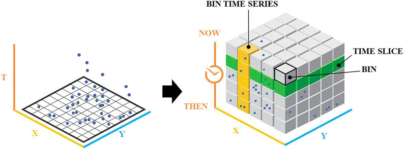
FIGURE 2. Space Time cube.
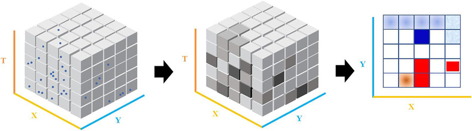
FIGURE 3. The process of spatiotemporal cold and hot spot analysis.
All trend analysis operations were completed in ArcGis 10.7.
2.3.3 Factor Detector
The Geodetector method (http://www.geodetector.org/) is based on statistical principles for spatial variance analysis. It represents a set of statistical methods to detect spatial variance and its mechanisms. This method is mainly applied to detect the spatial variance and to what extent factor explains the spatial variance of attribute.
Where q is the spatial variance of a factor indicator, which is used to detect the factor’s influence on land use activities. N is the sample size of the whole region.
In this paper, 18 townships were used as detection areas. Based on the existing studies and data accessibility, the accumulated area of land change in each township between 2000 and 2020 as a proportion of its administrative area was Y. The socioeconomic factors (change in GDP X1, change in the agricultural output value X2, change in the gross industrial output value X3, and change in the road network density X4) and natural environment (DEM X5, slope X6, average annual temperature change X7, and average annual precipitation change X8), for a total of eight factors. Since the statistical objects of socioeconomic data changed considerably from 1980 to 2000, this study also took the local development history into account to provide a context for the identified land activity mechanisms.
3 Results
3.1 Land Use Change and Transfer Path
As shown in Table 1, from 1980 to 2020, the land use changes in Baiyun District of Guangzhou were dominated by urbanization. The built-up land area increased from 26.1 km2 (1980) to 164.3 km2 (2020), an expansion of 138.2 km2. The growth rate was as high as 529.6%. From 1990 to 2000, the new built-up land was mainly distributed in the southern part of Baiyun District (the southern part of Shijing, Jiahe, the western part of Yongping, the eastern part of Songzhou, the southern part of Tonghe, the western part of Huangshi and the central part of Jingxi). From 2000 to 2005, it was mainly distributed in the central part of Baiyun District (the western parts of Taihe, Junhe and Yong-ping). From 2005–2010, it showed a large-scale scattered expansion in the study area (Taihe, Jinsha, bordering Shijing, Junhe and Jianggao, and the central part of Renhe) (Figure 4). Table 1 shows that the cropland area decreased from 340.1 km2 (1980) to 193.3 km2 (2020), a reduction of 146.8 km2 (43.2%). During this process, the percentage change in the area of forest and grassland, water body, rural settlement and other built-up land relative to built-up and cropland was only a maximum of 4%, and the overall land activity was stable. This indicates that the new built-up land was mainly transferred from cropland.
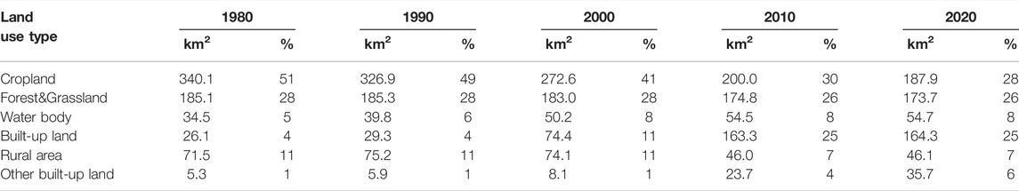
TABLE 1. Land-use changes in Baiyun District.
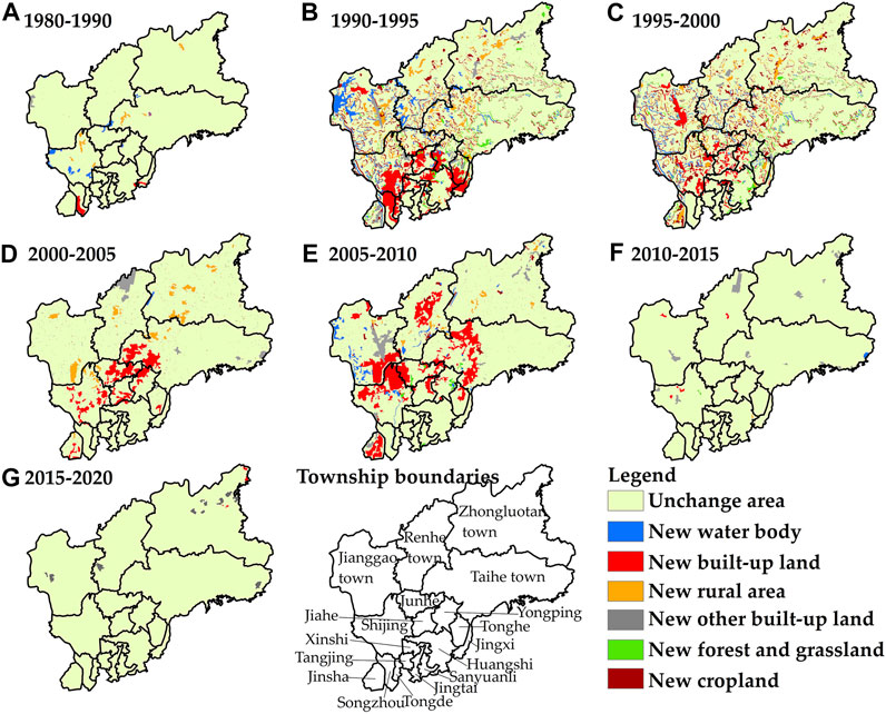
FIGURE 4. Spatial distribution of new land in each township at different times (A–G).
There were 936 land transfer paths from 1980 to 2020, so this paper only considers the land transfer paths with the amount of 2 km2 (Figure 5). In terms of transfer amount, land use change in Baiyun District was dominated by the invariance of each land type. The largest areas were 159.2 km2 of cropland and 154.4 km2 of forest and grassland (Table 2). The Sankey diagram shows that the period of 1990–2010 was the most diverse and active in land transfer paths, mainly in the form of transfers out of cropland into built-up land. Among these, the land transfer paths involving land between cropland and built-up land were cropland (1980–1990) to built-up land (1995–2020), cropland (1980–2005) to built-up land (2010–2020), cropland (1980–2000) to built-up land (2005–2020) and cropland (1980) to built-up land (1990–2020), with a transfer amount of 61.4 km2. The amount of land transfer of rural settlement was also significant and was mainly converted to built-up land and cropland. The total amount of rural settlements transferred to built-up land in different periods was 26.9 km2. The transfer of built-up land to cropland was the most notable, with all of it being transferred from cropland first and then back to cropland.
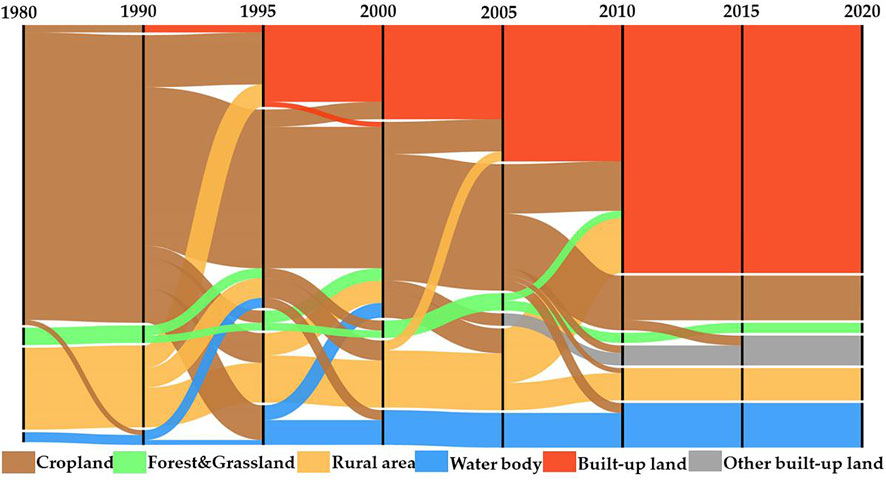
FIGURE 5. Land-transfer paths within different time periods, 1980-2020.
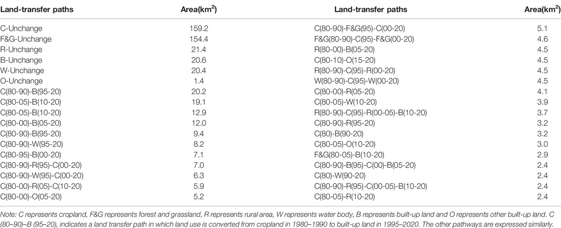
TABLE 2. Quantities of different land-transfer paths in 1980–2020.
In general, during 1980–2020, the main trend in land use change in Baiyun District was a large-scale decrease in cropland, which was mainly transformed into built-up land. Built-up land expanded massively by transforming large amounts of cropland and rural settlements. Although this land use change was dramatic, land transfer paths were dominated by the invariance of each land use type.
3.2 Spatiotemporal Cold and Hot Spots Distribution of Land Activity
The temporal distribution trend analysis of land activities in the cell grid was analyzed, and the Z-score was −2.44 with a p-value of 0.01. The land activity showed a decreasing trend throughout the study period. As shown in Figure 6, land activity in Baiyun District was dominated by continuous cold spots from 1980 to 2020, covering an area of up to 190.6 km2, accounting for 29% of the entire study area. It was mainly concentrated in the southeast near the urban center (Sanyuanli, Huangshi, Xinshi, Tangjing and Jingtai), and widely distributed in remote areas (Zhongluotan and the forest-dominated eastern part of Taihe). The second most prominent pattern was the Oscillating Cold Spot pattern, adjacent to or interconnected with the Consecutive Cold Spot and New Cold Spot areas. A multinuclear pattern spatially characterizes the Consecutive Hot Spot pattern. The most prominent areas showing this pattern were those bordering Jianggao, Shijing and Junhe, followed by the central part of Jinsha, the north-central part of Renhe and the local area of Taihe township (Figure 6).
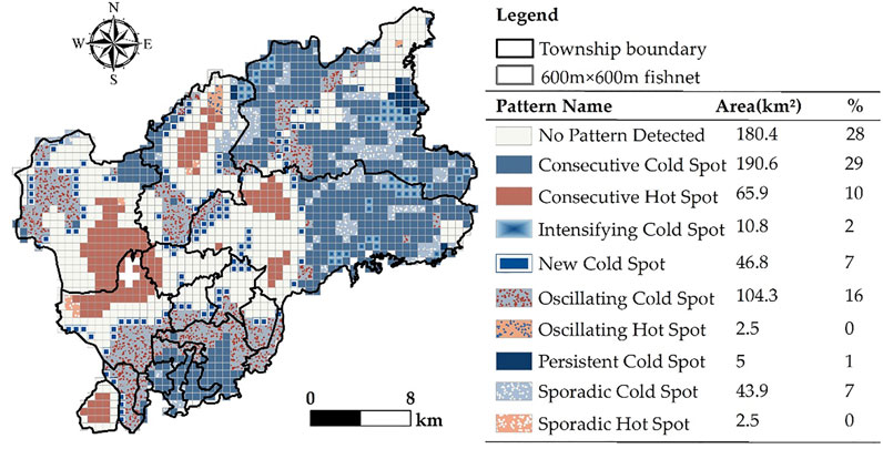
FIGURE 6. Distribution of spatiotemporal cold and hot spot trend and the quantity of each pattern in Baiyun District, 1980-2020.
The number and location of hot and cold hotspots of land activity in Baiyun District from 1980–2020 varied over time. The non-statistically significant cold or hot spots pattern was dominant in each period, but there were still obvious stable hot spots (Figure 7). During 1980–2010, a multinuclear pattern of land activity hotspots was very prominent and was mainly concentrated in the central and southern parts of the study area. Since 2010, however, the pattern of hotspots has rapidly weakened. It is noteworthy that the cold spot pattern, relative to land activity by period, only appeared for 1990–1995 and 1995–2000. Its main distribution is consistent with the spatiotemporal trends described above.
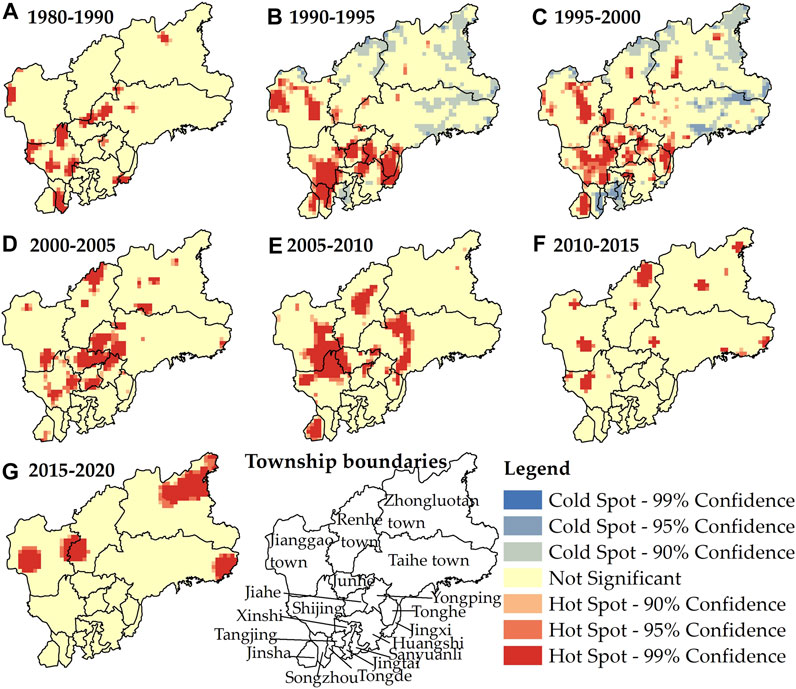
FIGURE 7. Analysis on hot spots of land activities in different periods from 1980 to 2020 (A–G).
3.3 Mechanisms Driving Spatial Heterogeneity of Land Activities
Based on a combination of expert experience and the Natural Breaks (Jenks) method, the classification method uniformly discretizes numerical quantities into type quantities. Natural environmental and socioeconomic factors were classified into 2 and 5 categories, respectively, using the Natural Breaks (Jenks) method (Table 3). The results show that over the past 20 years, socioeconomic factors significantly impacted the spatial pattern of land activities in Baiyun District, whereas the influence of natural environmental factors was relatively insignificant. In descending order of intensity, the main influencing factors (all having passed the significance test) were as follows: X1 (0.47) for change in GDP, X3 (0.44) for change in the gross industrial output value, X7 (0.35) for change in the average annual temperature, X5 (0.27) for DEM, X6 (0.27) for slope, X2 (0.26) for change in the agricultural output value, X4 (0.21) for change in the road network density and X8 (0.07) for change in average annual precipitation.
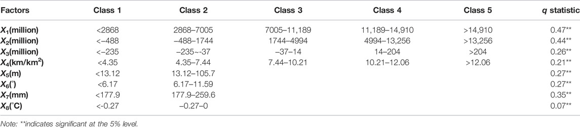
TABLE 3. The influencing factors and detection results of land-use change in Baiyun District, 2000-2020.
The interactions of different factors on the impact of land activity positively reinforce a single factor’s influence. The interaction detection results show that a two-factor enhancement dominated the interaction type. Compared with the single factor, the q-values of each factor increased to different degrees (Table 4). The changes in the average annual precipitation X7 had the most substantial influence on the interaction of socio-economic factors. The next most prominent performance was the interaction of road network density change X4 on GDP change X1 and agricultural output value change X2, which increased several times compared with its individual effects. The socioeconomic factors were bi-factorially enhanced in terms of the type of interaction. The exception was road network density change X4, which was non-linearly enhanced with GDP change X1 and agricultural output value change X2. It is worth noting that the interaction type between the change of road network density X4 and the natural environment factors was a nonlinear enhancement.
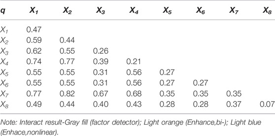
TABLE 4. Interactive detection results of regional differentiation of land-use change in Baiyun District, 2000-2020.
3.4 The Trend Turning of Land Use Morphology Process in Baiyun District Guangzhou From 1980 to 2020
The trend turning of land use morphology is the core of land use transition re-search, since regional land use morphology often changes in accordance with changes in the economic and social development stage. During the studied period, the land conversion caused conflicts in land use morphology, which were subsequently alleviated through corresponding policy measures. This process of land use conflict mitigation is known as land use transition. By combining the characteristics of the spatial heterogeneity mechanisms described in the previous section and local development history, we considered the changes in land use morphology, the conflicts, and alleviation methods in the development process of land use transition in Baiyun District. The land use transition process was divided into the following three stages and then applied to explore further the mechanism of the long-term land use transition (Figure 8).
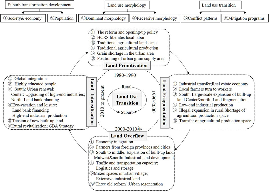
FIGURE 8. Suburban development patterns in different period of Baiyun District. Note: “Three old reform” refers to the transformation mode unique to Guangdong Province: old town, old factory, and old village transformation. “HCRS” refers to the Household contract responsibility system, a form of agricultural production responsibility system in which farmers contract land and other means of production and production tasks from collective economic organizations (mainly villages and groups) on a household basis. “GBA” refers to Guangdong-Hong Kong-Macao Greater Bay Area.
3.4.1 Land Primitivation in 1980–1990
Baiyun District is located in the transition zone between the low mountains of central Guangdong Province and the Pearl River Delta Plain. The north and northeast of Baiyun District are characterized by large hills and mountains, preserving large areas of pristine ecological forest. In the west and south, there are flat, broad alluvial plains with fertile soil and various soil types and genera, providing favorable conditions for a number of plantations (rice, vegetables, drought-tolerant cereals, peanuts, forestry). Therefore, since the reform and opening up, industrialization and urbanization were delayed in Baiyun District compared with the main urban area of Guangzhou. Traditional agricultural activities still dominate the study area, forming a stable spatial pattern of natural spaces and large-scale agricultural production. In the early stage, under the premise of not changing land use, the farmer families contracted the land to the collective and enjoyed full management autonomy as the primary production unit. As a result, the rural economy grew rapidly and provided sufficient labor and land for subsequent industrialization (Baiyun District Information Database in Guangzhou, China, 2021).
3.4.2 Land Fragmentation in 1990–2000
Since 1990, with the second wave of global industrial transfer and the promotion of the second round of the contract management responsibility system, low-end industries have become the target of foreign investment, and a large amount of rural collective land has been expropriated or illegally occupied (Long, 2012; Gong et al., 2019). At the same time, industrial production has also created a large number of employment opportunities. Local farmers have entered the workforce, and migrants from the surrounding cities and counties around Guangzhou have moved in to work (Yang, 2019). This has led to a boom in the informal expansion of self-housing and external leasing in remote areas. The real estate planned economy (1990-1995) and the real estate market economy (1996-2000) directly contributed to the large-scale construction of commercial housing in the southern part of Baiyun District (Su et al., 2005). Therefore, the 1990-2000 presented in Figure 4 also verifies the construction development in the north and south of Baiyun District. In addition, The “rural land capitalization” of Baiyun District has led to the rapid shrinkage of cropland area. However, the shortage of cropland in the urban area of Guangzhou and the timely open policy of purchasing and selling agricultural products caused Baiyun District to become the main grain supply source area for urban Guangzhou. At the same time, Baiyun District also became prominent in the northern transportation and export of agricultural products. As a result, the agricultural production space gradually shifted from the suburbs to the middle and outer suburban agricultural areas (Baiyun District Information Database in Guangzhou, China, 2021). The land space dominated by traditional agriculture in Baiyun District reduced rapidly, and the fragmentation of land development intensified. Spatially, there was a large area of built-up land in the south and fragmentation of land in the center and north.
3.4.3 Land Overflow in 2000–2010
Since the turn of the 21st century, the global economy has been developing in an integrated way, with industrial adjustment and upgrading and international transfer occurring in parallel (Yang et al., 2020). Baiyun District, which used to rely on traditional agriculture and low-end industries, was facing unprecedented challenges. Under the government’s leadership, there was a massive transfer of agricultural production space to urban residential and public built-up land in 2000–2010 relative to previous periods. The built-up land expanded from the south to the center of the district, and the urban villages formed in a low-cost way, outside of the modern urban management, and the land uses were highly mixed (Yang, 2019; Yao and Tian, 2020). Driven by the “Strong Industrial Zone,” “Modern Logistics Development Plan” and “Optimized Northern Development” polices, a large number of professional markets, logistics parks or industrial agglomeration areas were built the central and western regions and the northern part of remote areas. Thus, as shown in Figure 4, the expansion of other construction land (industrial land) from 2000 to 2010 was particularly significant relative to other periods. This also validates the significant role of gross industrial output as the second influencing factor on land use change. This construction was reliant on the transfer of rural collective land, which had the advantage of cheaper prices than urban areas (Baiyun District Information Database in Guangzhou, China, 2021). As a result, a large number of laborers from the surrounding inland provinces of Guangdong Province were absorbed. Since 2000, in response to the requirements of the tenth Five-Year Plan for developing the national economy, the north of Renhe Town in Baiyun District developed large-scale infrastructure land to construct the new Baiyun International Airport (Yang et al., 2020). In general, under the government’s coordination, the land activities during this period showed a significant trend of spatially pushed development from the middle to the north.
3.4.4 Land Intensification in 2010 to Present
The rapid population growth and urban expansion in the first decade of the 21st century led to the shortage of new built-up land and reserve land for further development (Gong et al., 2018a). In 2009, Baiyun District government mapped idle land, low-utility land, old factories and hillsides to supplement cropland (Baiyun District Information Database in Guangzhou, China, 2021). Under the premise of maintaining the current land use, the southern part of Baiyun District carried out the reconstruction of urban villages, evacuation of villages to build houses or revitalization of the stock of built-up land (Li et al., 2019). Thanks to better transport facilities and lower land rents, the central and northern parts took over the urban capital from the south (Gong et al., 2018b). In central Baiyun District, the old factories and historical sites were rebuilt into a fine chemical industrial zone, innovation industrial zone or science and technology park in the process of the “Exit the secondary industry and enter the tertiary industry” policy, and develop an “industrial clustering” regional model (Lin et al., 2019). The northern part focused on implementation as a land reserve planning region. Since 2010, Baiyun District has seen a decrease in the overall land-use changes under the land-intensive approach of limiting incremental land and excavating stock land. However, under the guidance of local and national planning divisions, the land functions have diversified, leading to a spatial pattern of ecological tourism in the east, Baiyun New City in the south, a creative industry gathering area in the middle, an industrial logistics area in the west, and an airport economic zone in the north of the district (People’s Government of Baiyun District, Guangzhou City, 2022a; People’s Government of Baiyun District, Guangzhou City, 2022b).
3.5 Discussion
3.5.1 The Trend Turning of Land Use Morphology in Urban Suburb
Our research results confirm that the trend turning of land use morphology can integrate land use morphology, use function, land use effect and the mechanism of land use change, and systematically sort out land use transition. Meanwhile, this study innovatively combines the history, policy measures and socio-economic development of the study area for a time-phased refinement analysis, which further confirms that land use transition in urban suburbs is a spatiotemporal evolution process of a complex man-land relationship. It is also the most direct result of multiple forces such as physical geography and socioeconomic conditions on land use morphology (Gong et al., 2019; Yao and Tian, 2020; Cao et al., 2021). The unique natural environment has shaped the original farming style, and the continuous improvement of the agricultural business system after the founding of New China has injected continuous momentum into agricultural production (Li H et al., 2021; Zhou et al., 2021). Since the reform and opening up, the original dual/dualistic structure has collapsed/subsequently disintegrated, and the urban suburbs have gradually developed on the periphery of the traditional rural core (Yang, 2019). The combination of foreign capital and local resource liberalization has contributed to the conversion of land use morphology from hybridization to large-scale development. The limited land resources are gradually formed into the regional space of specific function positioning types under the rational allocation planning (Gong et al., 2018a). However, urban suburbs continue to be faced with the problem of limited land resources. Even under the multiple constraints of the “Controlling growth and forcing storage” policy, the problems of mixed tenure, spatial fragmentation, poor living environment and industrial inefficiency continue to persist (Gong et al., 2019; Yang, 2019; Yao and Tian, 2020; Cao et al., 2021). The recent construction of the Guangdong-Hong Kong-Macao Bay Area and the national strategy of rural revitalization have brought new opportunities and challenges to the urban suburbs of the Pearl River Delta (Gong, et al., 2019). However, it remains unclear how the new circumstances could help to solve the problem of land use transition and stimulate the vitality of land use development in the urban suburbs. In addition, the reshaping of the position of urban suburbs in the urban-rural relationship and consideration of how the urban suburbs should act as a bridge between urban and rural area need to be topics of further research.
3.5.2 Reliability of Land Use Transition Method
With the accumulation of spatiotemporal data and the advent of the big data era, feature mining of spatiotemporal data with geology as the object of analysis with statistical methodology has brought a new opportunity for land use research. For example, it can solve the problems of massive data analysis and visualization on different spatial units and in different periods (Wang et al., 2014). Moreover, it can also meet the needs of attribute diversification, function differentiation and mechanism diversification, and realize long time series of evolutionary laws, interactive dynamics and prediction research. The spatiotemporal feature mining method selected in the current study is an effective coupling of spatiotemporal statistics and land system science. The method focuses on the breakthrough of land use research from traditional two-dimensional plane space to the realization of three-dimensional spatial visualization, which is a fundamental attempt to study the mono-temporal land use morphology to long-temporal land use transition (Esri, 2021; Wang et al., 2010). As in this study, the cold hotspot analysis of land activities breaks through the traditional two-dimensional land transfer, effectively visualizing the multidimensional land use morphology and revealing the dominant land use morphology. Based on this approach, we deeply explored the changes of recessive land use morphology, for example, to reveal the process of land substitution caused by the changes of socioeconomic development stages (such as industrial transfer, infrastructure projects) and the real problems derived from it. However, this study considered a combination of existing spatiotemporal data analysis methods, which continue to have associated problems such as the scale disunity of the source data, the lack of data attributes and the required improvement to the detection factor system. In addition, the uneven distribution of data acquisition at large spatial scales leads to a lack of spatiotemporal slice information, and the type data generation is biased (Wang et al., 2014; Zhou et al., 2020). Therefore, it remains necessary to conduct considerable spatiotemporal data analysis practice alongside the further innovation and development of spatiotemporal statistical methods and theoretical systems.
Conclusion
This study explores the land use transition path of a typical suburb using a spatio-temporal statistical combination approach. The combination of Space Time Cube and Geodetector methods revealed that land use in Baiyun District, a suburb of Guangzhou, has been dominated by the expansion of built-up land and the shrinking of cropland since 1980. Over the same period of land activity showed a continuous cold spot pattern, followed by an oscillating cold spot pattern. The overall land activity showed a downward trend. In the context of local history, we found that socioeconomic factors significantly affected the conversion of land use types in different development periods, leading to different conflict patterns. The land use transition in the urban suburb was transformed from morphology to quality, mainly through policy measures and continuous spatial transfer. Combined with the variability of spatiotemporal characteristics of land use, the study region was divided into four stages of land development: Land Primitivation from 1980 to 1990, Land Fragmentation from 1990 to 2000, Land Overflow from 2000 to 2010 and Land Intensification from 2010 to the present. The study region is at the forefront of China’s development, and its “urban suburb” identity is typical. So the results of this paper can provide a reference for the development of other urban suburbs in China. In addition, this study confirms that the introduced spatio-temporal statistical methods can be used to assist further research on land use transition. However, the factors influencing this paper still need to be further refined, especially those closely related to those areas with intensive land use activities.
Data Availability Statement
The raw data supporting the conclusion of this article will be made available by the authors, without undue reservation.
Author Contributions
YJ and JG: substantial contributions to conception and design, acquisition of data, analysis and interpretation of data; YC and CW: drafting the article and revising it critically for important intellectual content; CW: collecting the data.
Funding
National Natural Science Foundation of China NSFC project number:42071123 Approval of the year:2020.
Conflict of Interest
The authors declare that the research was conducted in the absence of any commercial or financial relationships that could be construed as a potential conflict of interest.
Publisher’s Note
All claims expressed in this article are solely those of the authors and do not necessarily represent those of their affiliated organizations, or those of the publisher, the editors, and the reviewers. Any product that may be evaluated in this article, or any claim that may be made by its manufacturer, is not guaranteed or endorsed by the publisher.
References
Asabere, S. B., Acheampong, R. A., Ashiagbor, G., Beckers, S. C., Keck, M., Erasmi, S., et al. (2020). Urbanization, Land Use Transformation and Spatio-Environmental Impacts: Analyses of Trends and Implications in Major Metropolitan Regions of Ghana. Land Use Policy 96, 104707. doi:10.1016/j.landusepol.2020.104707
Asquith, M., Backhaus, J., Geels, F., Golland, A., Hof, A., Kemp, R., et al. (2018). Perspectives on Transitions to Sustainability. Kongens, Denmark: European Environment Agency. ISSN 1725-9177. doi:10.2800/332443
Baiyun District Information Database in Guangzhou, China (2021). Baiyun District People’s Government. Available at: http://www.by.gov.cn/ (Accessed March 30th, 2022).
Cao, W., Zhou, S., and Zhou, M. (2021). Operational Pattern of Urban-Rural Integration Regulated by Land Use in Metropolitan Fringe of China. Land 10 (5), 515. doi:10.3390/land10050515
Chen, Z., Zhang, Q., Li, F., and Shi, J. (2021). Comprehensive Evaluation of Land Use Benefit in the Yellow River Basin from 1995 to 2018. Land 10, 643. doi:10.3390/land10060643
DeFries, R. S., Foley, J. A., and Asner, G. P. (2004). Land-use Choices: Balancing Human Needs and Ecosystem Function. Front. Ecol. Environ. 2 (5), 249–257. doi:10.1890/1540-9295(2004)002[0249:lcbhna]2.0.co;2
Elahi, E., Khalid, Z., Tauni, M. Z., Zhang, H., and Lirong, X. (2021). Extreme Weather Events Risk to Crop-Production and the Adaptation of Innovative Management Strategies to Mitigate the Risk: A Retrospective Survey of Rural Punjab, Pakistan. Technovation [in press], 102255. doi:10.1016/j.technovation.2021.102255
Elahi, E., Khalid, Z., and Zhang, Z. (2022b). Understanding Farmers' Intention and Willingness to Install Renewable Energy Technology: A Solution to Reduce the Environmental Emissions of Agriculture. Appl. Energ. 309, 118459. doi:10.1016/j.apenergy.2021.118459
Elahi, E., Zhang, Z., Khalid, Z., and Xu, H. (2022a). Application of an Artificial Neural Network to Optimise Energy Inputs: An Energy- and Cost-Saving Strategy for Commercial Poultry Farms. Energy 244, 123169. doi:10.1016/j.energy.2022.123169
Esri.(2021). Arcgis 10.3 for Desktop Web Help: Create Space Time Cube. Available at: Http://Desktop.Arcgis.Com/En/Arcmap/10.3ltools/Space-Time-Pattern-Mining-Toolbox/Create-Space-Time-Cube.Htm (Accessed March 30, 2022).
Foley, J. A., DeFries, R., Asner, G. P., Barford, C., Bonan, G., Carpenter, S. R., et al. (2005). Global Consequences of Land Use. Science 309 (5734), 570–574. doi:10.1126/science.1111772
Gong, J., Hu, Z., Chen, W., Liu, Y., and Wang, J. (2018a). Urban Expansion Dynamics and Modes in Metropolitan Guangzhou, China. Land Use Policy 72, 100–109. doi:10.1016/j.landusepol.2017.12.025
Gong, J., Jian, Y., Chen, W., Liu, Y., and Hu, Y. (2019). Transitions in Rural Settlements and Implications for Rural Revitalization in Guangdong Province. J. Rural Stud. [in press]. doi:10.1016/j.jrurstud.2019.10.037
Gong, J., Jiang, C., Chen, W., Chen, X., and Liu, Y. (2018b). Spatiotemporal Dynamics in the Cultivated and Built-Up Land of Guangzhou: Insights from Zoning. Habitat Int. 82, 104–112. doi:10.1016/j.habitatint.2018.10.004
Grainger, A. (1995a). National Land Use Morphology: Patterns and Possibilities. Geography 80 (3), 235–245. Available at: https://www.jstor.org/stable/40572668.
Grainger, A. (1995b). The Forest Transition: An Alternative Approach. Area 27 (3), 242–251. Available at: https://www.jstor.org/stable/20003580.
Gu, C. L. (2020). “Urbanization,” in International Encyclopedia of Human Geography. 2nd Edn. Elsevier, 141–153. ISBN: 9780081022955.
Guangzhou Statistic Bureau (2021). Information Database in Guangzhou, China. Available at: http://tjj.gz.gov.cn/?msclkid=724e5938b02b11ec901d076de0a5227a (Accessed March 30th, 2021).
Hagerstrand, T. (1982). Diorama, Path and Project. Tijd voor Econ. Soc. Geog 73 (6), 323–339. doi:10.1111/j.1467-9663.1982.tb01647.x
Hailu, A., Mammo, S., and Kidane, M. (2020). Dynamics of Land Use, Land Cover Change Trend and its Drivers in Jimma Geneti District, Western Ethiopia. Land Use Policy 99, 105011. doi:10.1016/j.landusepol.2020.105011
Hansen, A. J., Castri, F. D., and Naiman, R. J. (1988). Ecotones: what and Why? in a New Look at Ecotones: Emerging International Projects on Landscape Boundaries. Biol. Int. 17, 9–16.
Lambin, E. F., and Meyfroidt, P. (2010). Land Use Transitions: Socio-Ecological Feedback versus Socio-Economic Change. Land Use Policy 27 (2), 108–118. doi:10.1016/j.landusepol.2009.09.003
Li, C. (2021). Analysis Path of Diagnosis and Regulation of Regional Land Use Transition. Geographical Res. 40 (5), 1464–1477. doi:10.11821/dlyj020200457
Li, C., Wu, Y., Gao, B., Zheng, K., Wu, Y., and Li, C. (2021). Multi-scenario Simulation of Ecosystem Service Value for Optimization of Land Use in the Sichuan-Yunnan Ecological Barrier, China. Ecol. Indicators 132, 108328. doi:10.1016/j.ecolind.2021.108328
Li, H., Wang, L., Gong, J., Zhu, A.-X., and Hu, Y. (2021). Land-Use Modes of the Dike-Pond System in the Pearl River Delta of China and Implications for Rural Revitalization. Land 10 (5), 455. doi:10.3390/land10050455
Li, X., Hui, E. C. M., Chen, T., Lang, W., and Guo, Y. (2019). From Habitat III to the New Urbanization Agenda in China: Seeing through the Practices of the "three Old Renewals" in Guangzhou. Land Use Policy 81, 513–522. doi:10.1016/j.landusepol.2018.11.021
Li, Y., Li, Y., Karácsonyi, D., Liu, Z., Wang, Y., and Wang, J. (2020). Spatio-temporal Pattern and Driving Forces of Construction Land Change in a Poverty-Stricken County of China and Implications for Poverty-Alleviation-Oriented Land Use Policies. Land Use Policy 91, 104267. doi:10.1016/j.landusepol.2019.104267
Lin, X., Huang, B., Wu, J., Ge, M., and Lin, J. (2019). Industrial Upgrading with Innovation Production Service System: Evidence from Guangzhou, China. Proced. CIRP 83, 351–357. doi:10.1016/j.procir.2019.04.083
Liu, Y., and Li, Y. (2017). Revitalize the World's Countryside. Nature 548, 275–277. doi:10.1038/548275a
Long, H. L. (2012). Land Use Transition and Rural Transformation Development. Prog. Geogr. 31 (2), 131–138. doi:10.11820/dlkxjz.2012.02.001
Long, H., and Qu, Y. (2018). Land Use Transitions and Land Management: A Mutual Feedback Perspective. Land Use Policy 74, 111–120. doi:10.1016/j.landusepol.2017.03.021
Ma, L., Long, H., Tu, S., Zhang, Y., and Zheng, Y. (2020). Farmland Transition in China and its Policy Implications. Land Use Policy 92, 104470. doi:10.1016/j.landusepol.2020.104470
Nath, S., Shams, J., vanLaerhoven, F., and Driessen, P. (2022). The Impact of Decision-Making on Conflict: Rethinking the Roles of Technocrats and Residents during Tidal River Management in Coastal Bangladesh. Land Use Policy 117, 106103. doi:10.1016/j.landusepol.2022.106103
People's Government of Baiyun District, Guangzhou City (2022a). Baiyun District Functional Area Land Use Master Plan (2013-2020). Available at: http://www.by.gov.cn/gzjg/sghhzrzyjbyqfj/cxgh/content/post_4686258.html (Accessed March 30th, 2022a).
People's Government of Baiyun District, Guangzhou City (2022b). General Land Use Plan of Baiyun District, Guangzhou City (2010-2020). Available at: http://www.by.gov.cn/gzjg/sghhzrzyjbyqfj/cxgh/content/post_4671580.html(Accessed March 30th, 2022b).
Qu, S. J., Hu, S. G., Li, W. D., Wang, H., Zhang, C. R., and Li, Q. F. (2020). Interaction Between Urban Land Expansion and Land Use Policy: An Analysis Using the DPSIR Framework. Land Use Pol. 99, 104856. doi:10.1016/j.landusepol.2020.104856
Song, X. Q. (2017). Discussion on Land Use Transition Research Framework. Acta Geographica Sinica 72 (3), 471–487. doi:10.11821/dlxb201703009
Spöck, G., and Pilz, J. (2015). Incorporating Covariance Estimation Uncertainty in Spatial Sampling Design for Prediction with Trans-gaussian Random fields. Front. Environ. Sci. 3 (39), 1–22. doi:10.3389/fenvs.2015.00039
Su, J. Z., Wei, Q. Q., and Guo, H. L. (2005). The Mechanism and Adjustment of Urban Sprawl of Guangzhou. Acta Geographica Sinica 60 (4), 626–636. doi:10.11821/xb200504011
Turner, B. L., Lambin, E. F., and Reenberg, A. (2007). The Emergence of Land Change Science for Global Environmental Change and Sustainability. Proc. Natl. Acad. Sci. U.S.A. 104 (52), 20666–20671. doi:10.1073/pnas.0704119104
Wang, J. F., Ge, Y., Li, L. F., Meng, B., Wu, J. L., Bo, Y. C., et al. (2014). Spatiotemporal Data Analysis in Geography. Acta Geographoca Sinica 69 (9), 1326–1345. doi:10.11821/dlxb201409007
Wang, J. F., Li, X. H., Christakos, G., Liao, Y. L., Zhang, T., Gu, X., et al. (2010). Geographical Detectors‐Based Health Risk Assessment and its Application in the Neural Tube Defects Study of the Heshun Region, China. Int. J. Geographical Inf. Sci. 24 (1), 107–127. doi:10.1080/13658810802443457
Yanbo, Q., Guanghui, J., Wenqiu, M., and Zitong, L. (2021). How Does the Rural Settlement Transition Contribute to Shaping Sustainable Rural Development? Evidence from Shandong, China. J. Rural Stud. 82, 279–293. doi:10.1016/j.jrurstud.2021.01.027
Yang, Q. K., Duan, X. J., Wang, L., and Jin, Z. (2018). Land Use Transformation Based on Ecological-Production-Living Spaces and Associated Eco-Environmental Effects: A Case Study in the Yangtze River delta. Scientia Geographica Sinica 38, 97–106. doi:10.13249/j.cnki.sgs.2018.01.011
Yang, R. (2019). Spatial Differentiation and Mechanisms of Typical Rural Areas in the Suburbs of a metropolis: A Case Study of Beicun Village, Baiyun District, Guangzhou. Acta Geographica Sinica 74 (8), 1622–1636. doi:10.11821/dlxb201908010
Yang, R., Zhang, J., Xu, Q., and Luo, X. (2020). Urban-rural Spatial Transformation Process and Influences from the Perspective of Land Use: A Case Study of the Pearl River Delta Region. Habitat Int. 104, 102234. doi:10.1016/j.habitatint.2020.102234
Yao, Z., and Tian, L. (2020). How Did Collectivity Retention Affect Land Use Transformation in Peri-Urban Areas of China? A Case of Panyu, Guangzhou. J. Rural Stud. 79, 1–10. doi:10.1016/j.jrurstud.2020.08.009
Zhou, C. H., Sun, J. L., Su, F. Z., Yang, X. M., Pei, T., Ge, Y., et al. (2020). Geographic Information Science Development and Technological Application. Acta Geographoca Sinica 75 (12), 2593–2609. doi:10.11821/dlxb202012004
Zhou, Y., Li, X., and Liu, Y. (2021). Cultivated Land protection and Rational Use in China. Land Use Policy 106, 105454. doi:10.1016/j.landusepol.2021.105454
Keywords: land use transition, trend turning, space time cube, geodetector, urban suburb
Citation: Jian Y, Chen Y, Gong J, Wenli C and Chen K (2022) Application of Spatiotemporal Pattern Mining Methods for Land Use Transition Research: A Case Study of Baiyun District in Guangzhou. Front. Environ. Sci. 10:893217. doi: 10.3389/fenvs.2022.893217
Received: 10 March 2022; Accepted: 01 April 2022;
Published: 21 April 2022.
Edited by:
Jinlong Gao, Nanjing Institute of Geography and Limnology (CAS), ChinaReviewed by:
Qiao Weifeng, Nanjing Normal University, ChinaEhsan Elahi, Shandong University of Technology, China
Copyright © 2022 Jian, Chen, Gong, Wenli and Chen. This is an open-access article distributed under the terms of the Creative Commons Attribution License (CC BY). The use, distribution or reproduction in other forums is permitted, provided the original author(s) and the copyright owner(s) are credited and that the original publication in this journal is cited, in accordance with accepted academic practice. No use, distribution or reproduction is permitted which does not comply with these terms.
*Correspondence: Jianzhou Gong, Z29uZ2p6aDY2QDEyNi5jb20=