- 1School of Management Engineering, Shandong Jianzhu University, Jinan, China
- 2School of Civil Engineering, Shandong Jiaotong University, Jinan, China
- 3School of Public Administration, South China Agricultural University, Guangzhou, China
Land ecological security plays an important role in the sustainable land resources utilization and social economic development. In this study, the Pressure-State-Response (PSR) model was constructed to measure the land ecological security pattern based on grids scale of Jinan from 2006 to 2016. Then, Moran’s index was used to explore the spatial autocorrelation of the land ecological security score. Finally, the driving factors of land ecological security pattern differentiation in Jinan were revealed by using geographical detector method. The results showed that the level of land ecological security in Jinan, generally, decreased at the beginning and then gradually increased during the research periods. More specifically, land ecological security was represented as a downward trend in the central region and an upward trend in the southern mountainous area. The apparent regional heterogeneity of land ecological security level in Jinan showed the overall distribution pattern “low in the middle and high around” and the direction of urban expansion consistent with the low-level land ecological security. Land ecological security presented a significant spatial autocorrelation. The differentiation of land ecological security pattern was mainly driven by social and economic development factors, among which urban expansion was most important, so urban development should try to avoid occupying those areas with high level of land ecological security. From the study, the valuable information could be provided in the improvement of land ecosystem environment and in the facilitation of sustainable development.
1 Introduction
Land is the material basis for the survival and development of human society and the basic premise for the healthy development of an ecosystem (Zhang et al., 2007; Wu et al., 2019a; Liu et al., 2020). With the acceleration of industrialization and urbanization, human demand for land is increasing (Chen, 2007; Long et al., 2012; Wu and Zhang, 2012). Unreasonable land use not only makes more apparent the contradiction between increasing population and land use, but it also causes a series of ecological problems (Kim et al., 2009; Nunes et al., 2011). With the ecological problems attracting broad attention by the government, ecological security has gradually become a hot topic in the international ecological environment research field and a new theme of the sustainable development of the human economy and society (Steffen et al., 2015). Numerous studies have been carried out worldwide and a series of significant developments have been achieved (Yang et al., 2018).
The concept of land ecological security originates from ecological security, representing the health of environment and sustainability of land resources and ecosystems, which can provide steady ecological services and meet ecological needs for future generations (Wen et al., 2021). Studies have shown that land use can greatly influence the regional environment and ecosystem services, and land ecological security is important to the ecosystem (Liu et al., 2019b; Wu et al., 2019b). Especially with the rapid increase of population, the excessive pursuit of economic benefits of land use has destroyed the land ecology to a certain extent. Conversely, land ecological destruction has increasingly restricted human social and economic activities, and reduced land sustainability. At present, many regions are in a critical period of ecological environment quality transformation (Cohen, 2006). As the capital of Shandong, Jinan is in the stage of rapid urbanization and is faced with considerable discussion on land use and ecological environmental protection (Qi et al., 2020; Liu et al., 2021a). The systematic evaluation and analysis of land ecological security and its influencing factors have important significance for ecological civilization construction and high-quality social economic development in Jinan.
In recent years, land ecological security has attracted much attention (Yan et al., 2015; Feng et al., 2018; Guo et al., 2021). From the research content, scholars mainly carry out land ecological security evaluation from different research scales, indexes, and methods (Li et al., 2014; Li et al., 2019a; Liu et al., 2019a; Yang and Cai, 2020). Research scales are generally divided into time scale and space scale. The time scale includes static and dynamic. The spatial scale is mainly concentrated on provinces, cities, counties, a few important economic zones, and watersheds. The evaluation indexes of land ecological security are mainly constructed by Pressure-State-Response (PSR), Economy-Environment-Society, and Driving Force-Pressure-State-Impact-Response (DPSIR) (Wolfslehner and Vacik, 2008; Sekovski et al., 2012; Geissdoerfer et al., 2017). The evaluation methods mainly include the comprehensive index method, matter element model, gray correlation method, ecological footprint method, TOPSIS method, etc. (Behzadian et al., 2012; Gong et al., 2012; Li et al., 2019b; Ma et al., 2019; Seyedmohammadi et al., 2019). The existing research has enriched the research content of land ecological security and promoted the process of ecological civilization construction. However, the current research mainly focuses on large-scale regions (city and country), and it is difficult to accurately express the evaluation results. It is imperative to analyze the land ecological security based on a spatial scale of grids. Besides, the difficulty of existing evaluation index in adapting to the regional characteristics of the study area will cause poor management of specific land. In addition, the core of land ecological security lies in effective identification of key influencing factors which include such factors as social-economic development and human activities that tend to be ignored in previous studies, and thus should be given a comprehensive consideration.
From what has been discussed above, this study analyzed the spatiotemporal differentiation of land ecological security and its influencing factors based on multi-source data in Jinan from 2006 to 2016. The evaluation index system was established at the beginning by the use of the PSR model reflecting the interaction mechanisms between the natural and the social ecosystem. Then, land ecological security was evaluated based on 1 km*1 km grids determining the index weights by the entropy weight and analytic hierarchy process (AHP) method, and the spatiotemporal pattern was analyzed thoroughly. Finally, the geographical detector method was employed to identify the dominant factors influencing the spatial differentiation of land ecological security from four aspects. The results can provide meaningful insights for sustainable land use and sustainable urban development, and facilitate decision-makers to formulate refined optimization countermeasures. The objectives of this study were (1) to evaluate the land ecological security and analyze the spatiotemporal pattern in Jinan; and (2) to investigate the influencing factors driving the spatial differentiation of land ecological security.
2 Materials and Methods
2.1 Study Area
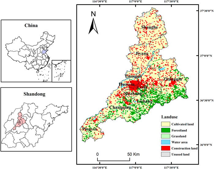
Jinan, located in the middle of the Shandong province in China, stands at the edge of a foothill and an alluvial plain with high topography in the south and low topography in the north (Figure 1). Its location close to the mountain Tai in the south and the Yellow River in the north makes the city vital to ecological environmental protection. Because of the “72 famous springs,” it also has the reputation as a “Spring City.” Meanwhile, it is one of the central cities in the south of Bohai Rim and the middle and lower reaches of the Yellow River.
2.2 Data Source
The data is divided into land spatial statistics and socio-economic statistics. The land spatial statistics obtained from the Jinan Land Resources Department and other relevant departments, include current land utilization statistics, land use annual alteration investigation statistics, investigation achievement of cultivated land backup resources, capital farmland delimitation, ecological function delimitation, biodiversity conservation, and ecological conservation district data. The socio-economic data was collected from Jinan Statistical Yearbook (for 2007, 2012, and 2017), the environmental collection bulletin, and the 13th Five-Year-Plan forestation development strategy. Through recalculation, the data is recalculated into 8460 grids (1 km*1 km).
2.3 Methodology
2.3.1 Establishment of PSR Model Index System
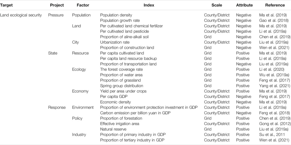
The study, based on the PSR model, selected 24 indicators to construct the land ecological security evaluation index system in Jinan (Table 1). Among the system, the direct influences on the land ecological security exerted by different utilization patterns can be reflected by the project “Pressure,” from which the indexes were constructed from seven indicators: population density, population growth rate, per cultivated land chemical fertilizer, per cultivated land pesticide, proportion of aline-alkali soil, urbanization rate, and proportion of construction land. The project “State” indicated the current situation or future tendency of the target, containing ten indicators for the construction of the indexes: per capita cultivated land, per capita land resource backup, proportion of transportation land, forest coverage rate, proportion of water area, proportion of grassland, spring group distribution, yield per area under crops, per capita GDP, and economic density. “Response,” another project in the system, representing the efforts made in environmental rehabilitation and adjustments, included seven more indicators to construct the indexes: proportion of environmental protection investment in GDP, carbon emission per billion yuan in GDP, proportion of forestation, effective irrigation area, natural reserve, proportion of primary industry in GDP, and proportion of tertiary industry in GDP. On the whole, the PSR model reflects the integration of nature, society, and human beings.
2.3.2 Standardization of the Index
Given the great dimensional variations between different indicators, we performed logarithmic transformation and standardized all evaluation indicators within each grid cell. In total, 13 positive indicators and 11 negative indicators were established considering the impact of each indicator on land ecological security. The formulas for standardization were indicated below (Zhang et al., 2017).
where
2.3.3 Determination of Weights
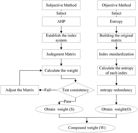
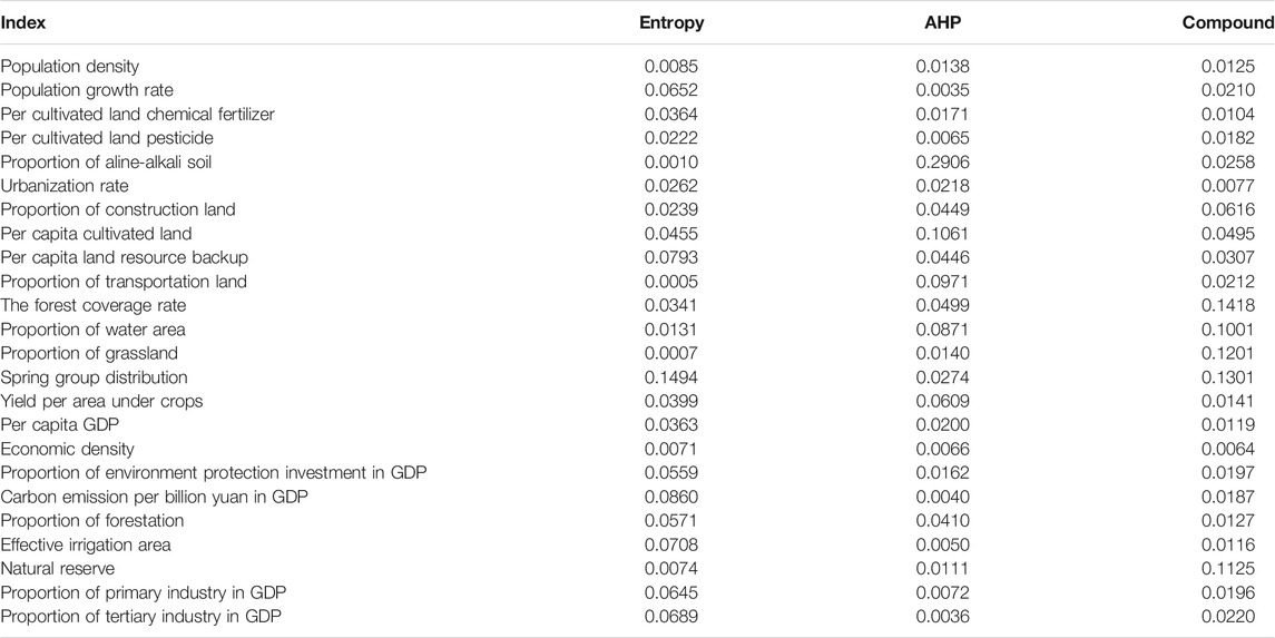
The determination of weight plays a very important role in multi-index comprehensive evaluation. The methods of weight determination can be divided into subjective and objective. The main methods of subjective evaluation include Delphi, cycle score, AHP, and empirical estimation (Okoli and Pawlowski, 2004; Geist, 2010). The main methods of objective evaluation include factor analysis, cluster analysis, principal component analysis, and entropy weight method (Blashfield and Aldenderfer, 1978; Lansangan and Barrios, 2009; Li et al., 2010; Liu et al., 2021b). Subjective methods are easily limited and influenced by the judge’s own conditions while objective methods cannot flexibly add the experience of experts. Therefore, this study usesd entropy weight method and AHP to determine the index weight so as to establish a scientific and reasonable index weight system (Figure 2). The formula of compound weight is shown in formula 3. The calculation results of compound weight were as follows (Table 2).
where
The result was based on the principle that the single score of each grid cell was calculated by multiplying the standardized data with the corresponding weight. Then, we added up all the scores of each indicator so as to get the results of land ecological security. The equation for this formulation was indicated below.
where
2.3.4 Classification of Land Ecological Security
In order to make the overall characteristics of land ecological security more prominent, the Jenks Natural Breaks method was used to classify the regional types (Feng et al., 2017; Liu et al., 2019a). The result further showed that the land ecological security of Jinan was divided into five levels: Secure (I), Sub-secure (II), Moderate (III), Sensitive (IV), and Severe (V) (Table 3).
2.3.5 Spatial Autocorrelation Analysis
Exploratory spatial data analysis was performed to quantify spatial heterogeneity, detect spatial autocorrelation patterns, and identify clusters of similar incidence and outliers (Oom and Pereira, 2013). Spatial autocorrelation analysis consists of global and local spatial autocorrelation. Global spatial autocorrelation can be observed by the global Moran’s I statistic. However, the global statistic gives a measure of overall clustering but it is still under investigation as well in the location of clusters or outliers or the type of spatial correlation that may exist in the data. Therefore, a detailed characterization of the clustering characteristics of the land ecological security was conducted by local indicators of spatial autocorrelation (LISA) and Moran scatterplots. The formulas were indicated below.
where n represents the number of all grid cells; Xi and Xj represents the observation of location i and j, respectively; Wij represents the element of the spatial weights matrix w corresponding to the observation pair (i,j), and represents the component that incorporates “space.” The scores of both indexes range from −1 to 1, but Moran’s I demonstrate that the positive mean grid cells with similar values cluster together, as well as the negative means grid cells with dissimilar values. The nature of spatial association can be categorized into four types: “High-High” (I, first quadrant) and “Low-Low” (III, third quadrant) with spatial cluster of similar grid cells; “Low-High” (II, second quadrant) and “High-Low” (IV, fourth quadrant) with spatial cluster of dissimilar grid cells.
2.3.6 Geographical Detector Analysis
Geographical detector is a statistical method to detect spatial differentiation and reveal the driving factors behind it (Yang et al., 2019; Zhu et al., 2020). There are spatial differences in land ecological security which is affected by many factors. For an illustrative purpose, this study quantitatively explored the dominant factors driving the spatial differentiation of land ecological security level by using the geographical detector in different periods. In this method, the larger the q-statistic, the stronger the explanatory power of the factor. The q-statistic ranges from 0 to 1. The calculation formula was as follows:
where
3 Results
3.1 Variation of Land Ecological Security Structure
In 2006, moderate and sub-secure regions covered an area of 4,054.39 km2, accounting for over half of the study area (Figure 3). Specifically, moderate security areas added up to 2,039.35 km2 taking the largest proportion of the entire city (i.e., 25.5%); what’s more, sub-secure areas added up to 2,015.04 km2 accounting for 25.19%. In 2011, the area of moderate security area reached 2231.19 km2, accounting for 27.89% of the total area and followed by sensitive area, accounting for 24.90%. Both of the two areas respectively increased by 9.41 and 52.78% compared to 2006. However, secure areas covered an area of 1,050.79 km2, decreasing by 35.79% from 2006. Sub-secure and severe areas covered about 1,758.75 and 966.31 km2 respectively, accounting for 21.99 and 12.08% of the total area, decreasing by 12.72 and 3.77%, respectively. On the whole view, the land ecological security of Jinan decreased from 2006 to 2011. Specifically, levels of secure and sub-secure areas were converted into moderate and sensitive areas while some scattered instances of severe areas were converted to sensitive.
In 2016, secure areas added up to 1,219.03 km2, increasing by 16.01% from 2011. Sub-secure areas covered about 1,832.13 km2 accounting for 22.91% of the total area, and increasing by 4.17% from 2011. Moderate areas added up to 3,220.01 km2 and accounted for 40.26% of the total area, increasing by 44.32% from 2011. Sensitive and severe areas covered 1,159.82 and 567.76 km2 accounting for 14.50 and 7.10%, decreasing by 41.77 and 41.24% respectively compared to 2011. The results show that the overall condition of land ecological security has improved from 2011. All these changes are benefited from Jinan’s great emphasis on environmental protection. The awareness of environmental protection has been widely publicized among the people and heavily polluted industries have been forced to move outside of the middle region of Jinan. Furthermore, since the establishment of 12th Five-Year Plan of China, the local government worked hard in upgrading the tertiary industry as the predominant so as to improve the land ecological security.
3.2 Analysis of Spatiotemporal Pattern
The land ecological security of Jinan has continuously changed with the development and construction of the city. The land ecological security of Jinan was characteristically low in the middle, but relatively high in the surrounding areas. The ecological security in the middle region was overwhelmingly negative categorized at the severe level. In contrast, the east, west, south, and north regions were categorized in a positive ecological condition. This was because most construction had been concentrated in the middle region, which is the political, economic, and cultural center of Jinan.
In 2006, the situation of land ecological security was better in Jinan, and the main types were moderate and sub-secure (Figure 4A). The levels of land ecological security varied from different regions. More specifically, land ecological security in the central regions (Lixia, Shizhong, Huaiyin, Tianqiao, and the north of Licheng) was represented as severe and sensitive, influenced by the high population density, high urbanization rate, and almost full load of land carrying capacity. Land ecological security was represented as secure and sub-secure in the southern regions (the south of Licheng, Zhangqiu, and Changqing) due to the regions’ status as the ecological conservation area where the forests and water area were widely distributed and human activities were very little. In the middle and north of Jiyang and Zhangqiu, land ecological was mainly represented as moderate and sensitive, which could be because the development of secondary and tertiary industries led to many human activities in the region, seriously interfering with the ecological environment. The land ecological security was represented as sensitive in the middle and west of Changqing and the middle and north of Pingyin. In a word, the rapid development in the region may cause a negative ecological security situation.
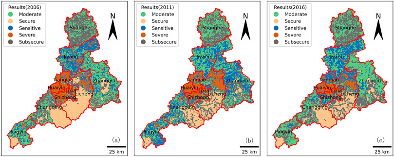
FIGURE 4. Land ecological security of Jinan from 2006 to 2016. (A–C) represent the results in 2006, 2011 and 2016.
In 2011, the overall land ecological security of Jinan worsened (Figures 4B). The ecological security of the north exhibited a mostly moderate pattern. In particular, the general ecological security of Shanghe decreased. In contrast, the land ecological security of Jiyang improved with fewer areas categorized as sensitive or severe. Decision-makers in the Jiyang strengthened controls on environmental governance, increased the environmental protection investment, shut down heavily polluting industries, and reduced carbon emission gradually to improve the ecological condition. The land ecological security of the south also deteriorated. Specifically, the ecological effect in the fringe of the area weakened with fewer areas classified as secure and moderate. The land ecological security of the east also deteriorated, with a wide occurrence of sensitive areas. The ecological condition of the middle of Zhangqiu worsened because of the rapid development of the secondary industries, in conjunction with little environmental investment. Conversely, the south of Zhangqiu was in a better ecological condition, possessing more water area and woodlands. Furthermore, the ecological condition of the west seriously declined due to the rapid development of secondary and tertiary industries resulting in a decrease of per capita cultivated land and increase of transportation land.
In 2016, areas classified as Severe dropped in the middle region of Jinan and were converted to Sensitive, especially in the north of the Licheng (Figure 4C). This trend was also observed in the Tianqiao and Shizhong. The overall ecological condition improved as demonstrated by Shanghe. The area with land ecological security represented as moderate in the middle region changed distinctly and then converted into a considerable proportion of sub-secure areas, which was due to a rapid increase in environmental protection investment, predominant development of the tertiary industry, and allocating more resources for afforestation to improve ecological security. The improvement of land ecological security in the east of Jinan City was attributed to the implementation of Zhangqiu’s policy of not sacrificing nature reserves and reducing carbon emission. At the same time, the strict management measures also improved land ecological security in the south of Jinan. The areas characterized as sensitive decreased by 87.78% and the areas characterized as moderate increased in the west of Jinan.
Generally speaking, the spatial difference of land ecological security in Jinan was obvious. The level of ecological security in the central built-up area was low. In recent years, the areas with land ecological security represented as severe continues to increase, and the scope of increase is basically consistent with the direction of urban expansion. Due to the underdevelopment of the area, the southern ecological conservation area was of great significance to maintain the ecological balance. As it is difficult to recover from the damage, the area was a key area for strengthening control. The situation of land ecological security in Jiyang, northern Zhangqiu, and western Changqing was poor, while it in the south of Shanghe and Pingyin was good. Urbanization not only improved people’s living standards but also caused the incomplete structure and irreversible function of regional land ecosystem. Coordinating the relationship between economic development and ecological protection, strengthening the supervision of key ecological protection areas will significantly improve the level of land ecological security in Jinan.
3.3 Exploration of Spatial Agglomeration Characteristics
The weight matrix based on a spatial distance relationship was established by employing the data from the evaluation results of land ecological security in 2006, 2011, and 2016. Applying the Global Moran’s index method, the Moran’s I index of the comprehensive value of land ecological security of Jinan was computed, after which the values were visualized in scatter plots. In said plots, the X-axis represents the observational value (i.e., standardization), and the Y-axis represents the weighted mean of the values surrounding the observational value (Figure 5).
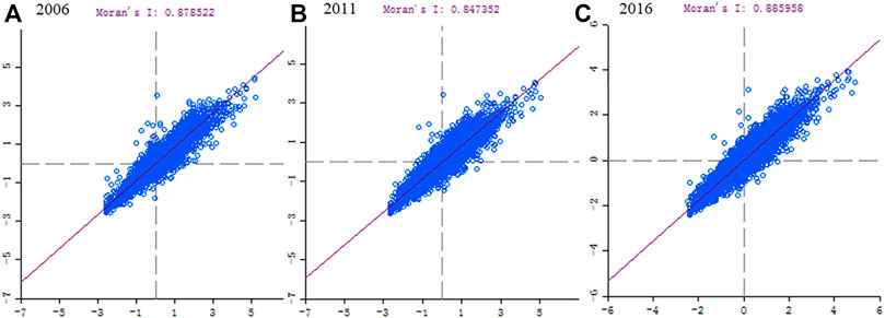
FIGURE 5. Scatter plot of Global Moran’s index derived from Jinan’s land ecological security in different years. (A–C) represent the results in 2006, 2011 and 2016.
The Moran’s I values of land ecological security were 0.879, 0.847, and 0.886 in 2006, 2011, and 2016, respectively, and its statistical significance was tested via the Monte Carlo simulation method. The result indicated a significant spatial autocorrelation (p < 0.01), confirming a distinct global positive spatial correlation within the land ecological security of Jinan, illustrating continuity and dependency between the 1 km × 1 km grid cells. Regions with similar land ecological security conditions tended to cluster together. Moran’s I decreased from 2006 to 2011, indicating a weakening correlation between the level of land ecological security and spatial distribution, thus resulting in polarization and stronger local autocorrelation. However, Moran’s I increased from 2011 to 2016, and correlations strengthened once again.
Taken together, the spatial association was classified as “High-High” (H-H) and “Low-Low” (L-L) for clusters of similar grid cells, while “Low-High” (L-H) and “High-Low” (H-L) for clusters of dissimilar grid cells. The H-H classification represents grid cells with values as high as the surrounding cells. This type of grid cells was mainly observed in the southeast of the Changqing district, the south of Licheng district, the middle of Zhangqiu district, as well as the southwest of Pinyin county (Figure 6). These observations corresponded with the land ecological security conditions discussed above, indicating that areas of high ecological security conditions were often classified as H-H. From 2006 to 2016, the number of H-H areas in the south Licheng district decreased consistently, and so did the number of secure-level areas. It is mainly because of the fast development of tourism, more and more human activities increased the incidence of natural hazards, thus resulting in a more vulnerable ecosystem. In contrast, the number of H-H type areas increased in the Zhangqiu district since 2011, which was consistent with improvements in Zhangqiu district’s ecological condition. This was attributed to the intervention of decisions makers, leading to more resource allocation and attention to environmental protection and sustainable economic development.
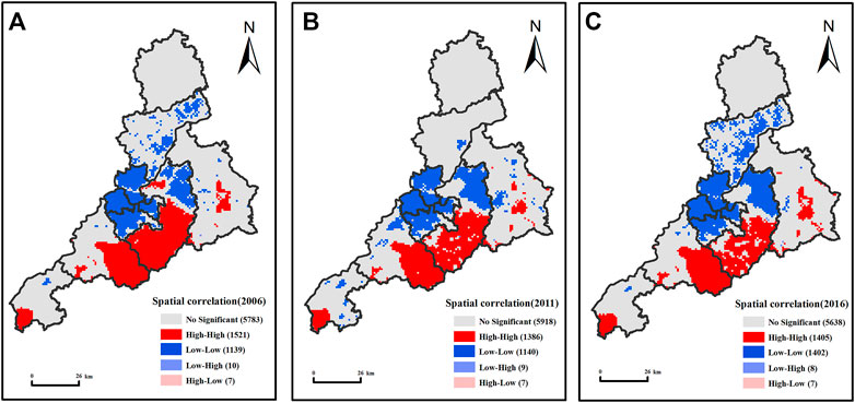
FIGURE 6. Spatial correlation of land ecological security condition in different years. (A–C) represent the results in 2006, 2011 and 2016.
L-L type areas represent regions where the values were as low as the surrounding ones. This type of grid cells was mainly observed in Shizhong, Lixia, Huaiyin, Tianqiao, and the east of the Licheng district. L-L type areas often corresponded with areas of severe land ecological security condition. Changes could be observed from 2006 to 2016. For instance, there was an inversion in the number of L-L type areas from 2006 to 2011, after which a large proportion of L-L type areas reemerged from 2011 to 2016. Both trends were observed within the Jiyang district. H-L type and L-H type areas represented a very small proportion of the study area, mostly interspersed in the periphery of H-H type and L-L type areas. Also, a large proportion of non-significant areas was observed mostly in the Shanghe and Pinyin counties, and most of the Zhangqiu district.
3.4 Identification of Influencing Factors
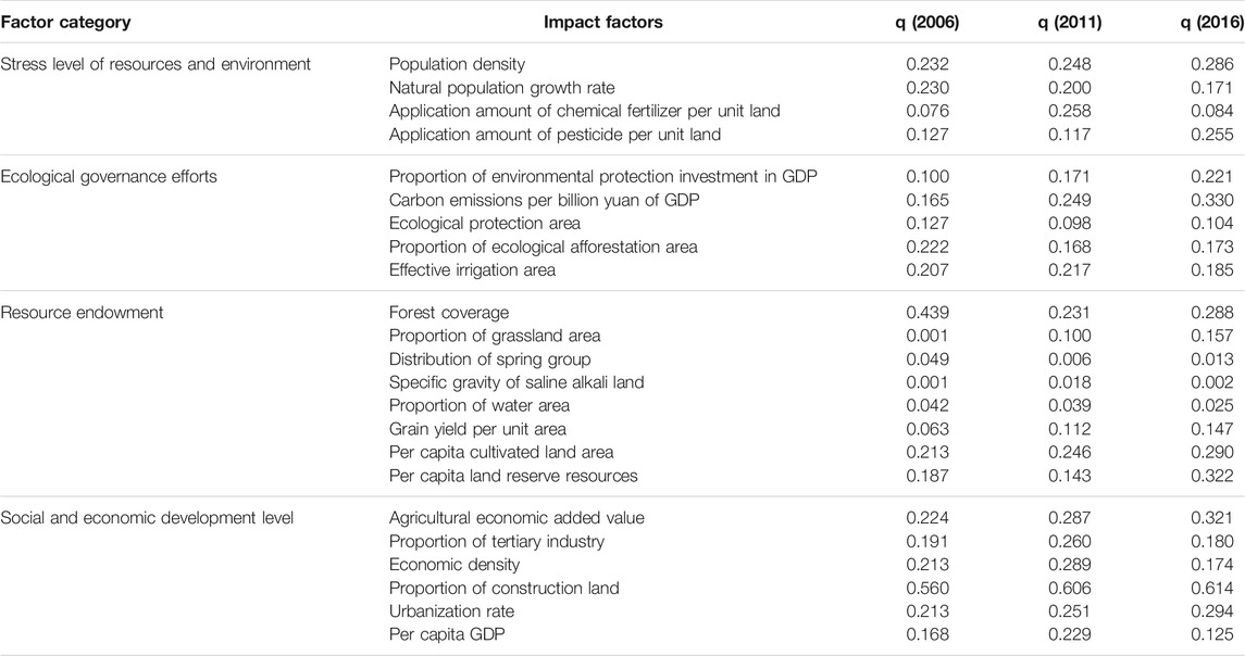
The spatial differentiation of land ecological security is affected by many factors. For that reason, it is of great significance to identify the main driving factors for the formulation of regional refine control measures. The results were shown in Table 4. At the significance level of 1%, the factor with q-statistic greater than 0.25 was selected as the dominant factor. The main driving factors corresponding to different time points are also changing. The main influencing factors in 2006 were the proportion of construction land and forest coverage. The main factors in 2011 were the proportion of construction land, economic density, agricultural economic added value, proportion of tertiary industry, fertilizer application per unit of cultivated land, and urbanization rate. The main factors in 2016 were the proportion of construction land, carbon emissions per billion yuan of GDP, per capita land reserve resources, agricultural economic value added, urbanization rate, per capita cultivated land area, forest coverage, population density, and pesticide application per unit of cultivated land.
There is a great correlation between resource and environment stress level and land ecological security. The increasing q value of population density indicated that the influence of population on the differentiation of land ecological security was increasing. In contrast, the q value of natural population growth rate was decreasing, which indicated that its influence was gradually weakening. Compared with 2006, the q value of chemical fertilizer and pesticide application per unit cultivated land increased in 2016. Cultivated land played an increasingly important role in maintaining the structure and function balance of the ecosystem. The change of population development level also had a great impact on land ecological status. Especially in recent years, the consumption of resources has been increasing for the rapid increase of population in the central area of Jinan.
Ecological governance is of great significance to alleviate the pressure of land ecological security and maintain the state of ecological security. In the study periods, the q values of the proportion of environmental protection investment in GDP were 0.100, 0.171, and 0.221, respectively. The q values of carbon emissions per billion yuan GDP were 0.165, 0.249, and 0.330, respectively. Their continuous growth indicated that the impact of economic and industrial structure transformation on land ecological security differentiation was increasing. Take Shanghe as an example; its proportion of environmental protection investment in GDP increased, and the level of land ecological security in the region improved significantly. Compared with 2006, the q values of ecological protection area, proportion of ecological afforestation area, and effective irrigation area decreased in 2016, which indicated that their impact on the spatial differentiation of land ecological security was weakened.
The influence degree of resource endowment factors on the spatial differentiation of land ecological security is different. The strongest explanatory factor was forest coverage. The q values were 0.439, 0.231, and 0.288, respectively, which indicated that the impact of this factor on land ecological security was weakened. The ecological status of areas with high forest coverage, such as the south of Licheng and the southeast of Changqing, was better.
The level of social and economic development has the strongest explanation for the spatial differentiation of land ecological security. During the study periods, the proportion of construction land had the greatest impact on land ecological security and its q values were 0.560, 0.606, and 0.614, respectively. The expansion of construction land has changed the structure of land cover and land ecosystem. The q values of agricultural economic added value and urbanization rate increased continuously, which showed that the explanatory power was increasing. The q values of per capita GDP were 0.168, 0.229, and 0.125, respectively. The q values of the proportion of the tertiary industry were 0.191, 0.260, and 0.180, respectively. The q values of economic density were 0.213, 0.289, and 0.174, respectively. The explanation degree of these three factors to spatial heterogeneity showed the characteristics of first increasing and then decreasing.
4 Discussion
Land ecological security plays an important role in regional socio-economic development and ecological environment protection. The land ecological security level was evaluated and the spatiotemporal differentiation was analyzed in Jinan from 2006 to 2016. Results showed that the land ecological security decreased first and then increased, and the level was improved in 2016 compared with those in previous years. This finding was consistent with many studies which the land ecological security was also presented as an upward trend in general (Hu et al., 2019; Yang et al., 2021). This is closely related to China’s recent emphasis on ecological and environmental protection. Meanwhile, obvious spatial differentiation of land ecological security within Jinan was found in our study. In fact, land ecological security has also been reported to show regional characteristics (Wen et al., 2021). Taking Jinan as an example, to study its land ecological security is not only conducive to the proposal of land optimization countermeasures but also conducive to alleviate the land contradiction in Jinan and improve the path of urban sustainable development. At the same time, it also provides a practical reference for the research of other cities.
The relationship between land ecological security and influencing factors is very complicated (Feng et al., 2018). In our study, the social and economic development, especially the construction land proportion, was found to have more explanatory power on land ecological security differentiation than other factors. Related studies also indicated that human activities have significant impact on regional land ecological security over natural factors (Yang et al., 2020; Wen et al., 2021). In addition, the results of this study also showed that the main driving factors were different at different time points. In 2006, resource endowment and socio-economic development level had the greatest impact on land ecological security differentiation. In 2011, the level of social and economic development restricted the improvement of land ecological security. In 2016, the spatial differentiation of land ecological security was largely explained by the intensity of ecological governance, the level of population development and the level of social and economic development. Therefore, only by formulating corresponding land ecological security optimization schemes at different times can we better serve urban sustainable development. Only by paying attention to the image of human activities on land ecological security can we realize the win-win situation of regional ecological protection and economic and social development.
Based on the grid scale, the spatial and temporal distribution pattern and driving factors of land ecological security in Jinan were analyzed, which further detailed the characteristics of regional land ecological security structure. However, due to the influence of data acquisition, the index system constructed failed to consider the regional ecological protection policy, public ecological cognition level, and other factors. Meanwhile, it is necessary to continually explore how to better realize the fusion of data at different scales, especially the rasterization of social-economic data to improve the research accuracy. In addition, although this study explored the driving factors of urban land ecological security, it failed to consider the interaction among the factors. These problems will be the important direction of future research, and multi-methods could be combined to better reveal the interactions between land ecological security and influencing factors.
5 Conclusion
Taking the grid as the evaluation unit, this study analyzed the spatiotemporal evolution characteristics and spatial differentiation law of land ecological security of Jinan in different years. The main conclusions are as follows:
(1) The level of land ecological security decreased first and then gradually increased from 2006 to 2016 in Jinan. Among them, the security level in the central region showed a downward trend, and gradually improved in the southern mountainous area.
(2) There was obvious heterogeneity of land ecological security level in Jinan. The overall distribution pattern was “low in the middle and high around.” The direction of urban expansion was consistent with the low-level land ecological security.
(3) There was a distinct global spatial positive correlation within the land ecological security. Roughly 15% of the surface of Jinan had low-value agglomeration, whereas roughly 17% exhibited high-value agglomeration. In addition, distribution patterns matched spatial agglomeration characteristics.
(4) There were differences in the driving factors of spatial differentiation of land ecological security in Jinan. Generally, the explanatory power of the level of social and economic development on the spatial differentiation of land ecological security was higher than other factors. Among them, the construction land proportion had the strongest explanatory power. Urban development should try to avoid occupying areas with high level of land ecological security.
Data Availability Statement
The original contributions presented in the study are included in the article/Supplementary Material, further inquiries can be directed to the corresponding author.
Author Contributions
JL and KJ designed the study, LZ was responsible for data collection and processing, XC and GD completed the analysis of the results and the writing of the manuscript, XC and KJ are responsible for the revision of the manuscript.
Funding
This research was funded by the National Natural Science Foundation of China (No. 41801173), the Science and Technology Project of the Housing and Rural Development Department in Shandong Province (No. 2019-R4-1), and the Doctoral Fund of Shandong Jianzhu University (No. X21011Z).
Conflict of Interest
The authors declare that the research was conducted in the absence of any commercial or financial relationships that could be construed as a potential conflict of interest.
Publisher’s Note
All claims expressed in this article are solely those of the authors and do not necessarily represent those of their affiliated organizations, or those of the publisher, the editors, and the reviewers. Any product that may be evaluated in this article, or claim that may be made by its manufacturer, is not guaranteed or endorsed by the publisher.
References
Behzadian, M., Khanmohammadi Otaghsara, S., Yazdani, M., and Ignatius, J. (2012). A State-Of The-Art Survey of TOPSIS Applications. Expert Syst. Appl. 39, 13051–13069. doi:10.1016/j.eswa.2012.05.056
Blashfield, R. K., and Aldenderfer, M. S. (1978). The Literature on Cluster Analysis. Multivariate Behav. Res. 13, 271–295. doi:10.1207/s15327906mbr1303_2
Chen, W., Chi, G., and Li, J. (20192019). The Spatial Association of Ecosystem Services with Land Use and Land Cover Change at the County Level in China, 1995-2015. Sci. Total Environ. 669, 459–470. doi:10.1016/j.scitotenv.2019.03.139
Chen, J. (2007). Rapid Urbanization in China: A Real challenge to Soil protection and Food Security. Catena 69, 1–15. doi:10.1016/j.catena.2006.04.019
Cohen, B. (2006). Urbanization in Developing Countries: Current Trends, Future Projections, and Key Challenges for Sustainability. Technol. Soc. 28, 63–80. doi:10.1016/j.techsoc.2005.10.005
Feng, Y., Liu, Y., and Liu, Y. (2017). Spatially Explicit Assessment of Land Ecological Security with Spatial Variables and Logistic Regression Modeling in Shanghai, China. Stoch. Environ. Res. Risk Assess. 31, 2235–2249. doi:10.1007/s00477-016-1330-7
Feng, Y., Yang, Q., Tong, X., and Chen, L. (2018). Evaluating Land Ecological Security and Examining its Relationships with Driving Factors Using GIS and Generalized Additive Model. Sci. Total Environ. 633, 1469–1479. doi:10.1016/j.scitotenv.2018.03.272
Gao, P. P., Li, Y. P., Sun, J., and Li, H. W. (2018). Coupling Fuzzy Multiple Attribute Decision-Making with Analytic Hierarchy Process to Evaluate Urban Ecological Security: A Case Study of Guangzhou, China. Ecol. Complexity 34, 23–34. doi:10.1016/j.ecocom.2018.03.001
Geissdoerfer, M., Savaget, P., Bocken, N. M. P., and Hultink, E. J. (2017). The Circular Economy - A New Sustainability Paradigm? J. Clean. Prod. 143, 757–768. doi:10.1016/j.jclepro.2016.12.048
Geist, M. R. (2010). Using the Delphi Method to Engage Stakeholders: A Comparison of Two Studies. Eval. Program Plann. 33, 147–154. doi:10.1016/j.evalprogplan.2009.06.006
Gong, J., Liu, Y., and Chen, W. (2012). Land Suitability Evaluation for Development Using a Matter-Element Model: A Case Study in Zengcheng, Guangzhou, China. Land Use Policy 29, 464–472. doi:10.1016/j.landusepol.2011.09.005
Guo, D., Wang, D., Zhong, X., Yang, Y., and Jiang, L. (2021). Spatiotemporal Changes of Land Ecological Security and its Obstacle Indicators Diagnosis in the Beijing-Tianjin-Hebei Region. Land 10, 706. doi:10.3390/land10070706
Hu, M., Li, Z., Yuan, M., Fan, C., and Xia, B. (2019). Spatial Differentiation of Ecological Security and Differentiated Management of Ecological Conservation in the Pearl River Delta, China. Ecol. Indicators 104, 439–448. doi:10.1016/j.ecolind.2019.04.081
Kim, H., Kim, S., and Dale, B. E. (2009). Biofuels, Land Use Change, and Greenhouse Gas Emissions: Some Unexplored Variables. Environ. Sci. Technol. 43, 961–967. doi:10.1021/es802681k
Lansangan, J. R. G., and Barrios, E. B. (2009). Principal Components Analysis of Nonstationary Time Series Data. Stat. Comput. 19, 173–187. doi:10.1007/s11222-008-9082-y
Li, M., Sun, H., Singh, V., Zhou, Y., and Ma, M. (2010). Agricultural Water Resources Management Using Maximum Entropy and Entropy-Weight-Based TOPSIS Methods. Entropy 21, 364–1228. doi:10.3390/e21040364
Li, X., Tian, M., Wang, H., Wang, H., and Yu, J. (2014). Development of an Ecological Security Evaluation Method Based on the Ecological Footprint and Application to a Typical Steppe Region in China. Ecol. Indicators 39, 153–159. doi:10.1016/j.ecolind.2013.12.014
Li, H., Zhao, Y., and Zheng, F. (2020). The Framework of an Agricultural Land-Use Decision Support System Based on Ecological Environmental Constraints. Sci. Total Environ. 717, 137149. doi:10.1016/j.scitotenv.2020.137149
Li, J. X., Chen, Y.-N., Xu, C.-C., and Li, Z. (2019a). Evaluation and Analysis of Ecological Security in Arid Areas of Central Asia Based on the Emergy Ecological Footprint (EEF) Model. J. Clean. Prod. 235, 664–677. doi:10.1016/j.jclepro.2019.07.005
Li, Z. T., Yuan, M.-J., Hu, M.-M., Wang, Y.-F., and Xia, B.-C. (2019b). Evaluation of Ecological Security and Influencing Factors Analysis Based on Robustness Analysis and the BP-DEMALTE Model: A Case Study of the Pearl River Delta Urban Agglomeration. Ecol. Indicators 101, 595–602. doi:10.1016/j.ecolind.2019.01.067
Liu, C., Wu, X., and Wang, L. (2019a). Analysis on Land Ecological Security Change and Affect Factors Using RS and GWR in the Danjiangkou Reservoir Area, China. Appl. Geogr. 105, 1–14. doi:10.1016/j.apgeog.2019.02.009
Liu, W., Zhan, J., Zhao, F., Yan, H., Zhang, F., and Wei, X. (2019b). Impacts of Urbanization-Induced Land-Use Changes on Ecosystem Services: A Case Study of the Pearl River Delta Metropolitan Region, China. Ecol. Indicators 98, 228–238. doi:10.1016/j.ecolind.2018.10.054
Liu, R., Dong, X., Zhang, P., Zhang, Y., Wang, X., and Gao, Y. (2020). Study on the Sustainable Development of an Arid Basin Based on the Coupling Process of Ecosystem Health and Human Wellbeing under Land Use Change-A Case Study in the Manas River Basin, Xinjiang, China. Sustainability 12, 1201. doi:10.3390/su12031201
Liu, P., Hu, Y., and Jia, W. (2021a). Land Use Optimization Research Based on FLUS Model and Ecosystem Services-Setting Jinan City as an Example. Urban Clim. 40, 100984. doi:10.1016/j.uclim.2021.100984
Liu, W., Zhan, J., Zhao, F., Wei, X., and Zhang, F. (2021b). Exploring the Coupling Relationship between Urbanization and Energy Eco-Efficiency: A Case Study of 281 Prefecture-Level Cities in China. Sustain. Cities Soc. 64, 102563. doi:10.1016/j.scs.2020.102563
Long, H., Li, Y., Liu, Y., Woods, M., and Zou, J. (2012). Accelerated Restructuring in Rural China Fueled by 'Increasing vs. Decreasing Balance' Land-Use Policy for Dealing with Hollowed Villages. Land Use Policy 29, 11–22. doi:10.1016/j.landusepol.2011.04.003
Ma, L., Bo, J., Li, X., Fang, F., and Cheng, W. (2019). Identifying Key Landscape Pattern Indices Influencing the Ecological Security of Inland River Basin: The Middle and Lower Reaches of Shule River Basin as an Example. Sci. Total Environ. 674, 424–438. doi:10.1016/j.scitotenv.2019.04.107
Nunes, A. N., De Almeida, A. C., and Coelho, C. O. A. (2011). Impacts of Land Use and Cover Type on Runoff and Soil Erosion in a Marginal Area of Portugal. Appl. Geogr. 31, 687–699. doi:10.1016/j.apgeog.2010.12.006
Okoli, C., and Pawlowski, S. D. (2004). The Delphi Method as a Research Tool: An Example, Design Considerations and Applications. Inf. Manage. 42, 15–29. doi:10.1016/j.im.2003.11.002
Oom, D., and Pereira, J. M. C. (2013). Exploratory Spatial Data Analysis of Global MODIS Active Fire Data. Int. J. Appl. Earth Observation Geoinformation 21, 326–340. doi:10.1016/j.jag.2012.07.018
Qi, S., Guo, J., Jia, R., and Sheng, W. (2020). Land Use Change Induced Ecological Risk in the Urbanized Karst Region of North China: A Case Study of Jinan City. Environ. Earth Sci. 79, 280. doi:10.1007/s12665-020-09036-w
Sekovski, I., Newton, A., and Dennison, W. C. (2012). Megacities in the Coastal Zone: Using a Driver-Pressure-State-Impact-Response Framework to Address Complex Environmental Problems. Estuarine, Coastal Shelf Sci. 96, 48–59. doi:10.1016/j.ecss.2011.07.011
Seyedmohammadi, J., Sarmadian, F., Jafarzadeh, A. A., and McDowell, R. W. (2019). Development of a Model Using Matter Element, AHP and GIS Techniques to Assess the Suitability of Land for Agriculture. Geoderma 352, 80–95. doi:10.1016/j.geoderma.2019.05.046
Steffen, W., Richardson, K., Rockström, J., Cornell, S. E., Fetzer, I., Bennett, E. M., et al. (2015). Planetary Boundaries: Guiding Human Development on a Changing Planet. Science 347, 1259855. doi:10.1126/science.1259855
Su, S., Li, D., Yu, X., Zhang, Q., Xiao, R., Zhi, J., et al. (2011). Assessing Land Ecological Security in Shanghai (China) Based on Catastrophe Theory. Stoch. Environ. Res. Risk Assess. 25, 737746. doi:10.1007/s00477-011-0457-9
Wen, M., Zhang, T., Li, L., Chen, L., Hu, S., Wang, J., et al. (2021). Assessment of Land Ecological Security and Analysis of Influencing Factors in Chaohu Lake Basin, China from 1998-2018. Sustainability 13, 358. doi:10.3390/su13010358
Wolfslehner, B., and Vacik, H. (2008). Evaluating Sustainable forest Management Strategies with the Analytic Network Process in a Pressure-State-Response Framework. J. Environ. Manage. 88, 1–10. doi:10.1016/j.jenvman.2007.01.027
Wu, K.-y., and Zhang, H. (2012). Land Use Dynamics, Built-Up Land Expansion Patterns, and Driving Forces Analysis of the Fast-Growing Hangzhou Metropolitan Area, Eastern China (1978-2008). Appl. Geogr. 34, 137–145. doi:10.1016/j.apgeog.2011.11.006
Wu, Y., Tao, Y., Yang, G., Ou, W., Pueppke, S., Sun, X., et al. (2019a). Impact of Land Use Change on Multiple Ecosystem Services in the Rapidly Urbanizing Kunshan City of China: Past Trajectories and Future Projections. Land Use Policy 85, 419–427. doi:10.1016/j.landusepol.2019.04.022
Wu, Z., Lei, S., He, B.-J., Bian, Z., Wang, Y., Lu, Q., et al. (2019b). Assessment of Landscape Ecological Health: A Case Study of a Mining City in a Semi-arid Steppe. Int. J. Environ. Res. Public Health 16, 752. doi:10.3390/ijerph16050752
Yan, J., Xia, F., and Bao, H. X. H. (2015). Strategic Planning Framework for Land Consolidation in China: A Top-Level Design Based on SWOT Analysis. Habitat Int. 48, 46–54. doi:10.1016/j.habitatint.2015.03.001
Yang, Y., and Cai, Z. (2020). Ecological Security Assessment of the Guanzhong Plain Urban Agglomeration Based on an Adapted Ecological Footprint Model. J. Clean. Prod. 260, 120973. doi:10.1016/j.jclepro.2020.120973
Yang, Q., Liu, G., Hao, Y., Coscieme, L., Zhang, J., Jiang, N., et al. (2018). Quantitative Analysis of the Dynamic Changes of Ecological Security in the Provinces of China through Emergy-Ecological Footprint Hybrid Indicators. J. Clean. Prod. 184, 678–695. doi:10.1016/j.jclepro.2018.02.271
Yang, J., Song, C., Yang, Y., Xu, C., Guo, F., and Xie, L. (2019). New Method for Landslide Susceptibility Mapping Supported by Spatial Logistic Regression and GeoDetector: A Case Study of Duwen Highway Basin, Sichuan Province, China. Geomorphology 324, 62–71. doi:10.1016/j.geomorph.2018.09.019
Yang, Y., Song, G., and Lu, S. (2020). Assessment of Land Ecosystem Health with Monte Carlo Simulation: A Case Study in Qiqihaer, China. J. Clean. Prod. 250, 119522. doi:10.1016/j.jclepro.2019.119522
Yang, R., Du, W., and Yang, Z. (2021). Spatiotemporal Evolution and Influencing Factors of Urban Land Ecological Security in Yunnan Province. Sustainability 13, 2936. doi:10.3390/su13052936
Zhang, M. A., Borjigin, E., and Zhang, H. (2007). Mongolian Nomadic Culture and Ecological Culture: On the Ecological Reconstruction in the Agro-Pastoral Mosaic Zone in Northern China. Ecol. Econ. 62, 19–26. doi:10.1016/j.ecolecon.2006.11.005
Zhang, F., Liu, X., Zhang, J., Wu, R., Ma, Q., and Chen, Y. (2017). Ecological Vulnerability Assessment Based on Multi-Sources Data and SD Model in Yinma River Basin, China. Ecol. Model. 349, 41–50. doi:10.1016/j.ecolmodel.2017.01.016
Keywords: land ecological security, spatiotemporal differentiation, influencing factors, PSR model, geographical detector, Jinan
Citation: Liu J, Cao X, Zhao L, Dong G and Jia K (2022) Spatiotemporal Differentiation of Land Ecological Security and Its Influencing Factors: A Case Study in Jinan, Shandong Province, China. Front. Environ. Sci. 10:824254. doi: 10.3389/fenvs.2022.824254
Received: 29 November 2021; Accepted: 04 January 2022;
Published: 08 February 2022.
Edited by:
Fan Zhang, Institute of Geographic Sciences and Natural Resources Research (CAS), ChinaReviewed by:
Shanzhong Qi, Shandong Normal University, ChinaWei Liu, Shandong Normal University, China
Copyright © 2022 Liu, Cao, Zhao, Dong and Jia. This is an open-access article distributed under the terms of the Creative Commons Attribution License (CC BY). The use, distribution or reproduction in other forums is permitted, provided the original author(s) and the copyright owner(s) are credited and that the original publication in this journal is cited, in accordance with accepted academic practice. No use, distribution or reproduction is permitted which does not comply with these terms.
*Correspondence: Kun Jia, amlha3VuMjBAc2RqenUuZWR1LmNu
†These authors have contributed equally to this work
 Jinhua Liu1†
 Lesong Zhao
 Guanglong Dong
 Kun Jia