
95% of researchers rate our articles as excellent or good
Learn more about the work of our research integrity team to safeguard the quality of each article we publish.
Find out more
ORIGINAL RESEARCH article
Front. Environ. Sci. , 27 May 2015
Sec. Atmospheric Science
Volume 3 - 2015 | https://doi.org/10.3389/fenvs.2015.00024
This article is part of the Research Topic Wet and Dry Periods in Regions Surrounding the Atlantic Ocean Basin View all 11 articles
 Chris J. C. Reason*
 Sandi Smart
Moisture flux and rainfall anomalies over southern Africa that have occurred during strong warm SST events off the coast of Angola since 1950 are considered. These events typically occur during February-April (FMA), the main rainy season for Angola/northern Namibia. Eleven of these events have occurred in this 60 year period and each experiences increased rainfall somewhere in coastal Angola, and in 10 cases, somewhere in northern Namibia. Attention is focussed on the five events with the largest and most widespread positive rainfall anomalies over Africa south of 10°S; namely, 1963, 1986, 2001, 2006, 2011. All of these five events experienced increased moisture flux from the western tropical Indian Ocean, warm SST anomalies also in the south west Indian Ocean, and most also showed increased westerly moisture flux from the tropical south east Atlantic. The events also showed strong weakening of the mid-level anticyclonic conditions that occur over southern Africa during summer. This factor together with the distribution of anomalous uplift through the middle/upper troposphere appeared to match the areas of increased rainfall better than the areas of low level moisture convergence. Reported experiments with an atmospheric GCM forced with idealizations of the observed SST anomalies show rainfall anomalies consistent with the observed patterns.
Most of southern Africa is an austral summer rainfall region. This summer precipitation is associated with three major oceanic sources of moisture; traditionally the tropical western Indian Ocean has been thought to be the most important with the subtropical southwest Indian Ocean also being a substantial contributor of moisture for rain over the subtropical regions (e.g., D'Abreton and Lindesay, 1993). The third source is the South Atlantic basin but, historically, not much work has been done on its influences on southern African climate (Reason et al., 2006). However, Hirst and Hastenrath (1983) drew attention to the existence of warm events in the tropical South East Atlantic and rainfall over Angola and Namibia. These rainfall linkages were further explored by Rouault et al. (2003) while Vigaud et al. (2007) highlighted the importance of tropical Atlantic moisture flux for Congo Basin rainfall. South Atlantic moisture flux anomalies associated with SST dipole events in the midlatitudes (Fauchereau et al., 2003; Hermes and Reason, 2005) may also contribute to summer rainfall over subtropical southern Africa (Vigaud et al., 2009).
A warm pool (SST 26–29°C) develops in the tropical South East Atlantic Ocean, off the central and northern coast of Angola and north of the Angola Benguela Frontal Zone (ABFZ), during the austral summer and lasts until at least April. As the trade winds north of the ABFZ relax after spring and through summer, latent heat fluxes and upper ocean mixing reduce in this region, leading to the development of warm SSTs here (Reason et al., 2006; Rouault et al., 2007, 2009). Within the equatorial wave guide which includes the northern part of the warm pool, this seasonal relaxation of the easterly winds reduces the zonal pressure gradient, flattens the thermocline and leads to warming across the equatorial Atlantic (Philander and Pacanowski, 1986). Moisture emanating from the warm pool region is a secondary source for the summer rainfall region (Reason et al., 2006), but can make larger contributions during some summer wet spells (e.g., Cook et al., 2004). This tropical South East Atlantic moisture flux also feeds into the Angola low, a heat low that exists over northern Namibia / southern Angola during the summer half of the year, and which acts as the source region for the main synoptic summer rainfall producing system over subtropical southern Africa, the tropical temperate trough or tropical extra-tropical cloud band (Harrison, 1984; Hart et al., 2010).
Figure 1 shows schematically the locations of the Angola low, the cloudbands and the low level tropical convergence zones over southern Africa in the austral summer as well as the ABFZ which separates the warm tropical Angolan Current waters from the northern Benguela Current upwelling system off the coast of northern Namibia. Also apparent in Figure 1 is the narrow peninsula-like distribution of the southern African landmass and its termination in the subtropics in mid-ocean. It is this geography that enables the South Atlantic and Indian Oceans to play a very strong role in its climate.
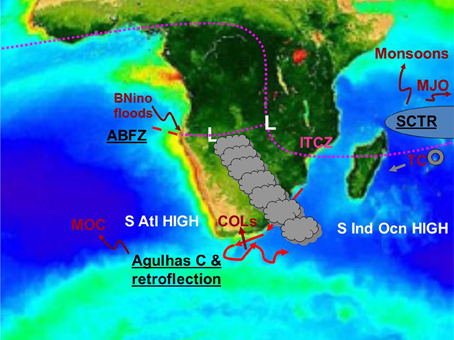
Figure 1. Schematic showing the main circulation features important for southern African rainfall during summer (Angola low denoted L, subtropical anticyclones, tropical convergence zones denoted as magenta dotted lines, cloud bands), unique regional oceanic features (Angola Benguela Frontal Zone denoted ABFZ, Agulhas Current and retroflection region, Seychelles-Chagos Thermocline Ridge denoted SCTR) and their climate impacts (Meridional Overturning Circulation denoted MOC, cut-off low induced flooding denoted COLs, tropical cyclones denoted TC, Madden Julian Oscillations denoted MJO, Benguela Niño induced floods denoted BNino).
In addition to the ABFZ, there are two other rather unique regional ocean features that strongly impact on southern African weather and climate. These are the Agulhas Current and its retroflection which sheds rings of warm, salty water into the South East Atlantic and the Seychelles Chagos Thermocline Ridge (SCTR) northeast of Madagascar. The Agulhas retroflection region has been implicated in many of southern South Africa's flooding disasters through moisture-laden low level wind jets impacting on the coastal mountains during severe cut-off low events (Singleton and Reason, 2007). SST anomalies here and in the South Atlantic regions west and southwest of South Africa also impact on winter rainfall over southwestern South Africa (Reason and Jagadheesha, 2005). While not an Atlantic feature, for completeness, it is mentioned that the SCTR is important for tropical cyclones, MJO activity and rainfall in the South West Indian Ocean / southeastern African region.
On the seasonally averaged scale, Figure 2 (derived from NCEP re-analyses, Kalnay et al., 1996) shows the 850 hPa level late summer (February to April) moisture flux and its convergence over the southern African region. This figure implies that the South Atlantic is less important than the South Indian Ocean for rainfall over the landmass. Note that the 850 hPa level is just above the height of the interior plateau that exists over much of southern Africa. Over this landmass, the cyclonic circulation and strong convergence over tropical southwestern Africa marks the Angola Low and its connection to the meridional arm of the Inter-tropical Convergence Zone (ITCZ) through the eastern Congo Basin, schematically shown in Figure 1. Further east in the southern Mozambique Channel, there is another cyclonic area of low level moisture convergence which may also act as a source region for cloud bands. Moisture flux from the subtropical South West Indian Ocean feeds into this feature and over subtropical southeastern Africa. This cyclonic feature is associated with the adjustment of the easterly trade winds to the Madagascan topography. Relative divergence and anticyclonic flow occurs over most of South Africa and southern Botswana / southern Zimbabwe, some of this due to the adjustment of the flow to the high lying areas over eastern South Africa. Northeast of Madagascar and stretching across the tropical South Indian Ocean is the low level convergence associated with the ITCZ. Another area of moisture convergence, fed by the northeast monsoonal flow from the tropical western Indian Ocean and a weaker westerly flow from the tropical South East Atlantic/Congo Basin, is apparent over equatorial East Africa, just to the south of Lake Victoria.
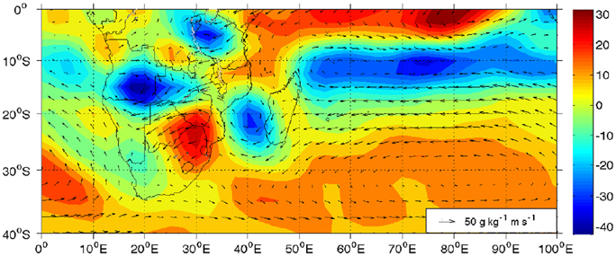
Figure 2. Climatological moisture flux and divergence for February–April at the 850 hPa level computed from NCEP re-analyses for 1980–2010. A scale moisture flux vector is given.
On this seasonal scale, it is apparent that most of the low level moisture flux over southern Africa emanates from the western Indian Ocean with the tropical South East Atlantic Ocean playing rather a minor role since the anticyclonic circulation of the South Atlantic High essentially exports moisture away from the landmass. However, on synoptic and intraseasonal scales, as well as on seasonal scales during certain years, moisture from the South Atlantic plays an important role (Cook et al., 2004; Vigaud et al., 2007, 2009; Hart et al., 2010). It is the latter case that is the main focus in this study; namely, late summer (February-April) warm events over the tropical South East Atlantic Ocean and their associated rainfall and moisture flux anomalies.
An association between SST anomalies off the Angolan / Namibian coast during austral summer and rainfall over the adjacent land has been known for some time (Hirst and Hastenrath, 1983). However, in recent decades, most attention has focussed on the warm events, called Benguela Niños (Shannon et al., 1986; Florenchie et al., 2003, 2004) for strong cases where they tend to be caused by wind anomalies in the equatorial Atlantic and subsequent Kelvin wave adjustment. These Benguela Niños are typically thought to be associated with above average rainfall in austral summer over western Angola and northwestern Namibia (Rouault et al., 2003). These authors examined four events (1984, 1986, 1995, 2001) and found that while there was evidence of increased rainfall along the coast, the magnitude of the rainfall anomalies varied markedly, and in some cases, there were also substantial anomalies over large inland areas. The suggested mechanism for the increased rainfall was increased evaporation off the warm SST anomaly and re-circulation of the regional moisture flux transport (mainly from the western Indian Ocean) over the tropical South East Atlantic leading to local moisture flux convergence over the coastal region.
A strong warm event also occurred in 2011 together with devastating floods in Namibia and Angola which displaced several hundred thousand people. During this period, the ephemeral Kuiseb River was able to flow as far as the Namibian coast near Walvis Bay for the first time since 1963. Thus, one of the aims here is to document the rainfall and SST anomalies during the very strong 2011 warm event and compare these to other recent warm events. The circulation anomalies associated with the strong warm events with large and widespread rainfall anomalies (five events) are then analyzed to better understand the rainfall patterns.
Extended re-constructed SST (ERSST) V3b data (Smith and Reynolds, 2004) are used to assess anomalies in the tropical South East Atlantic Ocean of interest here. Warm events are defined as those showing February-April (FMA) SST standardized anomalies about or greater than one standard deviation in a box off Angola (8–15°E, 10–20°S), the so-called ABA index (Rouault et al., 2009). Using this definition, strong warm events occurred in 1959, 1963, 1965, 1984, 1986, 1995, 1998, 1999, 2001, 2006, 2011—Table 1.
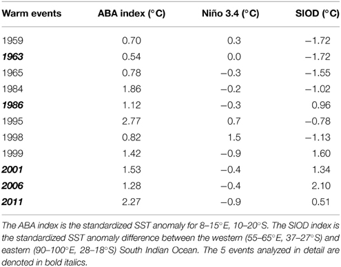
Table 1. Indices for tropical South East Atlantic warm events (ABA), and the subtropical South Indian Ocean dipole (°C) for the FMA season.
The FMA season is chosen since it is when Angola / northwest Namibia receive much of their annual rain and it corresponds to the time of maximum SST off their coasts. Global Precipitation Climatology Centre (GPCC) gridded data (Schneider et al., 2008) are used to assess rainfall anomalies because station data for some large areas in southern Africa, especially Angola, were not available to us. For the purposes of this study, southern Africa is defined as Africa south of 10°S. NCEP re-analyses (Kalnay et al., 1996) are used to compute moisture fluxes and atmospheric circulation anomalies. Unless otherwise stated, climatologies are constructing use a base period of 1980–2010.
Figure 3 which shows the standardized rainfall anomalies for all warm events since 1950 suggests that the events with the strongest and most widespread positive rainfall anomalies over southern Africa are 1963, 1986, 2001, 2006, and 2011. Although for completeness Figure 1 plots data to the equator, in this study southern Africa is considered to be Africa south of 10°S. Consistent with earlier work (e.g., Hirst and Hastenrath, 1983; Rouault et al., 2003), there are positive rainfall anomalies somewhere in coastal Angola in each event and somewhere in northern Namibia for 10 of the 11 events. In terms of Angola, the most consistent region of increased rainfall is the south, particularly the southwest, although the positive anomalies are weak for the 1984, 1998, and 1999 events. These three events are also accompanied by large areas of drier conditions over southern Africa. Thus, although it is generally accepted in the literature that the strong warm events are associated with large positive FMA rainfall anomalies in Angola and Namibia, Figure 3 indicates that there is substantial variation in the magnitude and spatial extent of the rainfall anomalies. For the remainder of this study, attention is focused on the five events with largest and most widespread rainfall anomalies over Africa south of 10°S; namely, 1963, 1986, 2001, 2006, and 2011.
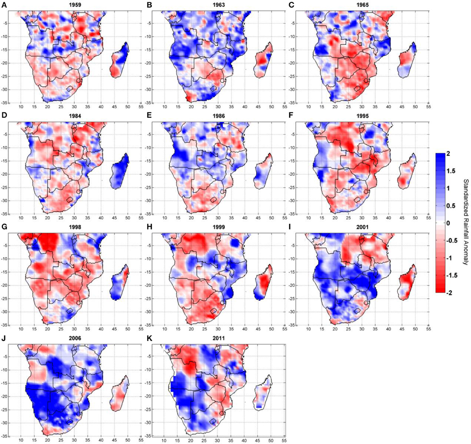
Figure 3. FMA rainfall anomalies (contour interval 10 mm) occurring during all warm SST events since 1950 using GPCC data (A) 1959, (B) 1963, (C) 1965, (D) 1984, (E) 1986, (F) 1995, (G) 1998, (H) 1999, (I) 2001, (J) 2006, and (K) 2011.
In addition to the tropical South East Atlantic, there is evidence that SST anomalies in the South West Indian Ocean can influence southern African summer rainfall (e.g., Reason and Mulenga, 1999; Behera and Yamagata, 2001; Reason, 2001). Figure 4 therefore plots the regional SST anomaly for the 1963, 1986, 2001, 2006, and 2011 events which had the largest and most widespread rainfall anomalies. It is evident that, off Angola, the 2011 case has the strongest FMA SST expression and that the first two events are weaker than the more recent three. A Hovmoller analysis of SST in the coastal South Atlantic along 10°E (Figure 5) for these five events confirms that 2011 was the strongest event, it also began earlier than the other cases and had peak SST anomaly in JFM rather than FMA. In the 1963 case, the FMA anomaly is relatively weak but then grows to become one of the strongest in winter. SST anomalies off Angola can last well into the winter (2001, 2006), or almost die away by April before re-generating in May (1963), and can occur before (2006) or after (1986) warming in the lower latitudes. Note that strong warm events further west in the equatorial zone in the central eastern Atlantic are known as Atlantic Niños and typically occur in austral winter (e.g., Chang et al., 2006).
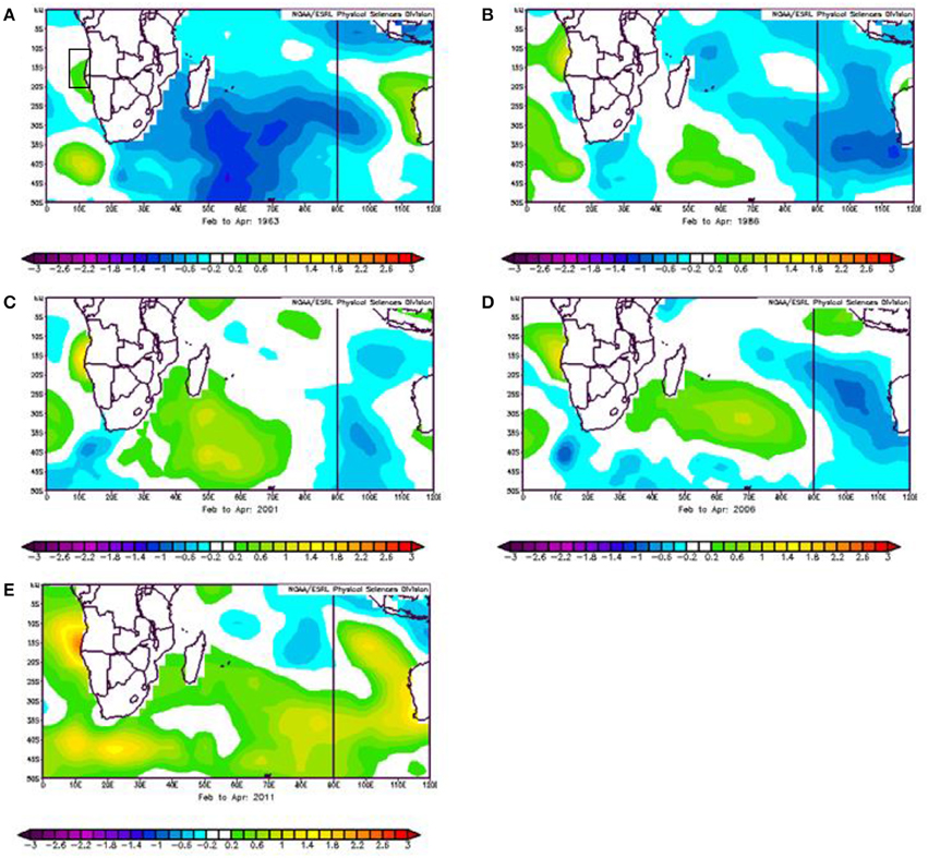
Figure 4. Regional SST anomalies during the 5 strong events (A) 1963, (B) 1986, (C) 2001, (D) 2006, (E) 2011. Contour interval is 0.2°C. The ABA box used to define the Benguela Niño events is shown in A).
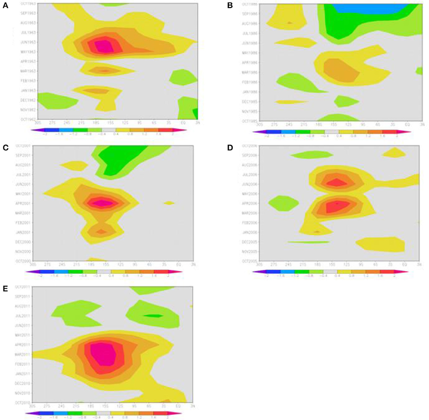
Figure 5. Hovmoller plot of SST anomaly (°C) along 10°E from 30°S to 3°N for the five strong events (A) 1963, (B) 1986, (C) 2001, (D) 2006, (E) 2011 from October of the preceding year to October of the event year.
A common feature to all the events except 1963 in Figure 4 is the presence of warm SST anomalies in the South West Indian Ocean. This event is also the only one that occurred prior to the 1976–1977 climate shift in the Pacific Ocean which may also have impacted on southern Africa and the South Indian Ocean (Miller et al., 1994; Baines and Folland, 2007; Manatsa et al., 2012). Based on observational analyses and experiments with an atmospheric GCM, Reason and Mulenga (1999) showed that warm SST anomalies in the South West Indian Ocean are associated with increased summer rainfall over southern Africa. There are also some similarities between the SST anomaly patterns in the South Indian Ocean in Figure 4 with the South Indian Ocean subtropical dipole, a climate mode peaking in intensity during JFM, and which is in its positive phase when there are warm SST anomalies in the southwest and cool SST anomalies off Western Australia (Behera and Yamagata, 2001). In this phase, increased summer rainfall also typically occurs over southern Africa (Behera and Yamagata, 2001; Reason, 2001, 2002) due to increased low level moisture flux from the western Indian Ocean toward southern Africa. Using the subtropical dipole index defined as the difference in SST anomaly between a western box (55–65°E, 37–27°S) and an eastern box (90–100°E, 28–18°S), Table 1 shows that 1986, 2001, 2006, and 2011 correspond to a positive dipole with only 1963 of the five being a negative dipole event. All these five events are either neutral with respect to El Niño or occurred during La Niña. Table 1 also shows that five of the other six events not considered in detail here correspond to negative South Indian Ocean dipole SST anomalies, confirmed in plots of the regional SST anomalies for these cases (not shown), and unfavorable for good summer rains.
Figure 6 shows the 850 hPa moisture flux anomalies for FMA 1963, 1986, 2001, 2006, and 2011. All cases show areas of increased moisture flux convergence over parts of Angola and Namibia, favorable for increased rainfall. The areas of increased (decreased) moisture flux convergence partially correspond to those of enhanced (reduced) rainfall in Figure 3. Relative to Figure 2, each case also shows increased moisture flux from the western tropical Indian Ocean or northern Mozambique Channel, although the anomalies are relatively weak for 1986. The moisture flux anomalies over the tropical Indian Ocean appear strongest in 1963 and extend across tropical southern Africa to the northern Angolan coast. On reaching the East African coast, some of the moisture flux turns northwestward and some southwestward, thereby opposing the mean flow and leading to relative convergence over the eastern landmass. A cyclonic anomaly exists over the tropical South East Atlantic, feeding moisture back into the Congo basin where it converges over eastern Zambia and southern Tanzania with that coming from the tropical Indian Ocean.
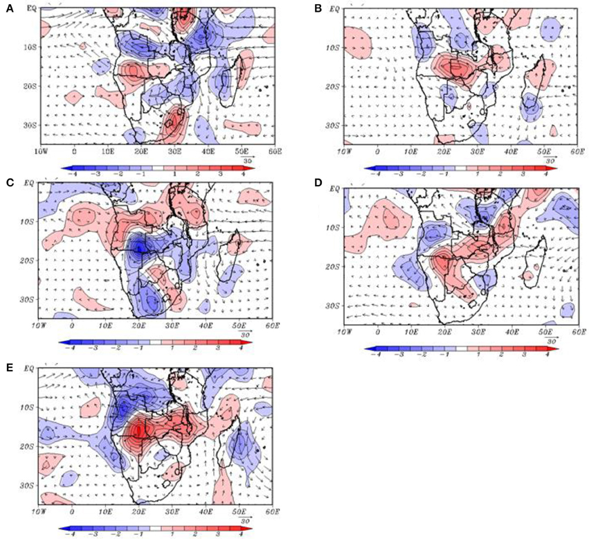
Figure 6. FMA anomalies in moisture fluxes and divergence (contour interval 0.5 × 10⁻⁸ gkg−1 s−1) at the 850 hPa level for (A) 1963, (B) 1986, (C) 2001, (D) 2006, and (E) 2011. Areas of relative convergence are shaded and a scale vector in gkg−1 ms−1 is shown.
In the case of 2001, some of the western Indian Ocean moisture flux turns southward across Mozambique and the southern part of the Channel with the rest converging over central southern Africa with a westerly flux from the tropical South East Atlantic. Anomalies in the southern Mozambique Channel and subtropical South West Indian Ocean are weak except for 1963 and 2001 which have northerly to northwesterly anomaly that opposes the mean flow and hence lead to relative convergence over Mozambique. By contrast, there are southerly to southeasterly anomalies in the southern Mozambique Channel in 2011, thereby augmenting the mean flow in places and leading to relative divergence over central and northern Mozambique and reduced rainfall there.
In addition to 2001, there is also a westerly flux from the tropical South East Atlantic in 1986 and 2006, although relatively weak in these two seasons. The situation in 2011 is more complex as easterly flux across the southern Congo and Angola then partially recirculates over northern Namibia and the coastal South East Atlantic Ocean and back toward central Namibia. In general however, the common important feature in each case is the enhanced flux toward the eastern landmass from the tropical western Indian Ocean/northern Mozambique Channel. This enhanced moisture flux is weakest in 1986, the event with the smallest spatial extent and magnitude of increased rainfall over southern Africa.
Low level moisture convergence is one factor needed for rainfall production, and Figure 2 suggests that, on seasonal scales, the Angola low, the southern Mozambique Channel region, and the areas near Lakes Victoria and Tanganyika, are where large values occur. However, another factor needed for substantial rainfall, particularly deep convection and the development of thunderstorms, is strong uplift through the troposphere. On average, anticyclonic conditions typically exist at 700 hPa and up through the middle troposphere over much of South Africa, Namibia, Botswana and southern Angola during the summer. This mid-level anticyclone, known as the Botswana High, caps the shallow heat lows (including the Angola Low) that are present in the summer half of the year over the western regions of subtropical southern Africa. Thus, in order for deep convection and associated rainfall to occur, these mid-level anticyclonic conditions need to break down or be shifted away from the landmass.
Figure 7 shows anomalies in 500 hPa geopotential height with each case showing negative anomalies over most of subtropical southern Africa and hence a weakening in the mean anticyclonicity. This level was chosen as representative of mid-level tropospheric conditions in this region that receives most of its summer rainfall through deep convection as thunderstorms (either isolated or organized systems). The patterns that are most favorable for convective rainfall are ones where the negative anomalies over southern Angola/northern Namibia (the Angola low source region for the cloud bands) stretch southeastwards toward the South West Indian Ocean to allow a link up with a midlatitude frontal feature (needed for tropical-extratropical cloud band development) together with an anticyclonic feature near the Mozambique coast. The latter is important to assist in advecting more moisture from the western Indian Ocean toward the landmass. All cases show the NW-SE orientation of the cyclonic anomalies over subtropical southern Africa with 2001 and 2006 also showing a clear anticyclonic feature near Mozambique, suggesting that these two seasons might be expected to have the most widespread regions of increased rainfall, consistent with Figure 3. The cyclonic anomalies over southern Africa are particularly strong in 1963, helping to explain the relatively large and widespread rainfall anomalies that occurred in that summer despite the SST anomalies off Angola and the ABA index being relatively weak and the SST anomalies in the South West Indian Ocean and the SIOD index being negative (Figure 4, Table 1).
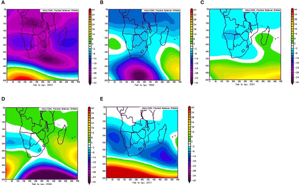
Figure 7. FMA geopotential height anomalies at the 500 hPa level for (A) 1963, (B) 1986, (C) 2001, (D) 2006, and (E) 2011. Contour interval is 2 m.
The favorable atmospheric conditions in Figures 6–7 are further reinforced by the anomalies in omega (pressure tendency) at the 500 hPa level (Figure 8), indicating that there was relative uplift in the middle troposphere over most of the areas of increased rainfall in southern Africa implying favorable conditions for deep convection. Most of the areas of relative subsidence at this level correspond to ones of reduced rainfall in Figure 3. Both 1963 and 1986 show positive omega anomalies over Botswana, and parts of Namibia and South Africa consistent with mainly dry conditions there. These positive omega anomalies are largest and most widespread in 1986, consistent with this season showing weaker positive rainfall anomalies than the other four.
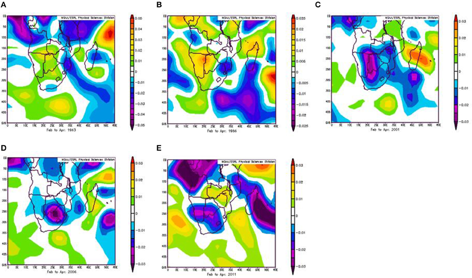
Figure 8. FMA omega (pressure tendency) at the 500 hPa level for (A) 1963, (B) 1986, (C) 2001, (D) 2006, and (E) 2011. Contour interval is 0.005 Pas−1.
The rainfall anomaly patterns in Figure 3 for 1963 and 1986 are broadly consistent with those generated by the HadAM3 GCM when forced with an idealized SST anomaly in the tropical South East Atlantic Ocean superimposed upon observed global monthly mean SST forcing (Hansingo and Reason, 2009). The model produced the largest positive rainfall anomaly over the central and southern Angolan coast with weaker positive anomalies extending into northern Namibia and eastwards into the central landmass. When an idealization of the warm SST pole in the South West Indian Ocean is added to the forcing, as occurred in 2001, 2006, and 2011, the rainfall anomaly pattern quite closely resembles that in Figure 3 for those years. The magnitudes of the rainfall anomalies in the model over certain inland areas are larger than those for the runs with just the Atlantic SST anomaly forcing. Conversely, when the warm SST anomaly in the South West Indian Ocean is replaced by a cool SST anomaly there, the model rainfall anomalies are reduced. These model results from Hansingo and Reason (2009) reinforce those indicated by the observational analyses that increased rainfall can be associated with the South East Atlantic warm events, with the areas of positive rainfall anomalies being more widespread and larger in magnitude when there are also positive SST anomalies in the subtropical South West Indian Ocean.
Since 1950, eleven strong warm SST events in austral summer have occurred in the tropical South East Atlantic off the Angolan and northern Namibian coasts. Each is accompanied by increases in coastal Angolan rainfall, with 10 cases also showing areas of wetter conditions somewhere in northern Namibia. Emphasis here is focussed on the five wettest events showing largest and most widespread positive rainfall anomalies over Africa south of 10°S; namely, 1963, 1986, 2001, 2006, 2011. While most of these five events occurred in the last decade, the timing of the total set of eleven events is mainly concentrated around the late fifties to mid-sixties, the mid-eighties, and then the most recent 15 years. The most recent event analyzed, 2011, is of particular interest as the devastating floods in Namibia and Angola displaced several hundred thousand people and the ephemeral Kuiseb River was able to flow as far as the Namibian coast near Walvis Bay for the first time since 1963.
Most of the summer rainfall in Africa, south of 10°S, is brought about by tropical extra-tropical cloud bands that link a tropical low somewhere over the land to a westerly disturbance passing south of South Africa. Each of the five wettest events showed increased low level moisture flux from the western Indian Ocean together with relative convergence of this moisture somewhere over Angola with the secondary moisture source coming from the tropical South East Atlantic Ocean. Areas of increased (decreased) southern African rainfall in each event only partially correspond to the areas of enhanced (reduced) low level moisture flux.
Another factor needed for deep convection and heavy rainfall to develop in the cloud bands is strong uplift through the troposphere. Associated with this is a need for the seasonally present mid-level anticyclone over southern Africa, the Botswana High, to break down or shift away from the landmass. Each of the five wettest events shows mid-level cyclonic anomalies, favorable for cloud band development, as well as strong areas of negative pressure tendency throughout the mid-troposphere to about the 500 hPa level, favorable for deep convection, and which correspond to the areas of increased rainfall in each case.
Four of the five wettest events also show a warm anomaly in the South West Indian Ocean known to be favorable for increased summer rainfall (Reason and Mulenga, 1999; Behera and Yamagata, 2001; Reason, 2001). Previous experiments (Hansingo and Reason, 2009) with the HadAM3 AGCM forced with idealizations of the observed tropical South East Atlantic and South West Indian Ocean SST anomalies confirm that there is increased rainfall over Angola and further inland in the model when forced with just the Atlantic SST anomalies superimposed on climatology. These positive rainfall anomalies are increased over interior areas as well as eastern South Africa and southern Mozambique when the South West Indian Ocean SST anomalies are added to the forcing.
Taken together, the observational and model analyses confirm the importance of both the tropical south east Atlantic and the western Indian Oceans as moisture sources for southern African summer rainfall during these warm SST events off the coast of Angola and northern Namibia. They also highlight the complexity of interannual rainfall variability over southern Africa which is sensitive not only to Atlantic and Indian Ocean SST anomalies but also to ENSO.
The authors declare that the research was conducted in the absence of any commercial or financial relationships that could be construed as a potential conflict of interest.
This work is based on the BSc (Hons) thesis of the second author. We thank NOAA CDC and KNMI Climate Explorer (http://climexp.knmi.nl) for data access and plotting tools.
Baines, P. G., and Folland, C. K. (2007). Evidence for a rapid global climate shift across the late 1960s. J. Clim. 20, 2721–2744. doi: 10.1175/JCLI4177.1
Behera, S. K., and Yamagata, T. (2001). Subtropical SST dipole events in the southern Indian Ocean. Geophys. Res. Lett. 28, 327–330. doi: 10.1029/2000GL011451
Chang, P., Fang, Y., Saravanan, R., Link, J., and Seidel, H. (2006). The cause of the fragile relationship between the Pacific El Niño and the Atlantic Niño. Nature 443, 324–328. doi: 10.1038/nature05053
Cook, C., Reason, C. J. C., and Hewitson, B. C. (2004). Wet and dry spells within particular wet and dry summers in the South African summer rainfall region. Clim. Res. 26, 17–31. doi: 10.3354/cr026017
D'Abreton, P., and Lindesay, J. (1993). Water vapour transport over southern Africa during wet and dry early and late summer months. Int. J. Climatol. 13, 151–170.
Fauchereau, N., Trzaska, S., Richard, Y., Roucou, P., and Camberlin, P. (2003). Sea surface temperature co-variability in the Southern Atlanitc and Indian Oceans and its connections with the atmospheric circulation in the southern Hemisphere. Int. J. Climatol. 23, 663–677. doi: 10.1002/joc.905
Florenchie, P., Lutjeharms, J. R. E., Reason, C. J. C., Masson, S., and Rouault, M. (2003). The source of Benguela Niños in the South Atlantic Ocean. Geophys. Res. Lett. 30, 1505. doi: 10.1029/2003GL017172
Florenchie, P., Reason, C. J. C., Lutjeharms, J. R. E., Rouault, M., Roy, C., and Masson, S. (2004). Evolution of interannual warm and cold events in the southeast Atlantic Ocean. J. Clim. 17, 2318–2334. doi: 10.1175/1520-0442(2004)017<2318:EOIWAC>2.0.CO;2
Hansingo, K., and Reason, C. J. C. (2009). Modelling the atmospheric response over southern Africa to SST forcing in the southeast tropical Atlantic and southwest subtropical Indian Oceans. Int. J. Climatol. 29, 1001–1012. doi: 10.1002/joc.1919
Harrison, M. S. J. (1984). A generalized classification of South African summer rain-bearing synoptic systems. J. Climatol. 4, 547–560. doi: 10.1002/joc.3370040510
Hart, N. C. G., Reason, C. J. C., and Fauchereau, N. (2010). Tropical-extratropical interactions over southern Africa: three cases of heavy summer season Rainfall. Monthly Weather Rev. 138, 2608–2623. doi: 10.1175/2010MWR3070.1
Hermes, J. C., and Reason, C. J. C. (2005). Ocean model diagnosis of interannual co-evolving SST variability in the South Indian and Atlantic Oceans. J. Clim. 18, 2864–2882. doi: 10.1175/JCLI3422.1
Hirst, A. C., and Hastenrath, S. (1983). Atmosphere–ocean mechanisms of climate anomalies in the Angola–tropical Atlantic sector. J. Phys. Oceanogr. 13, 1146–1157.
Kalnay, E., Kanamitsu, M., Kistler, R., Collins, W., Deaven, D., Gandin, L., et al. (1996). The NCEP/NCAR 40-Year Reanalysis Project. Bull. Amer. Meteor. Soc. 77, 437–471.
Manatsa, D., Reason, C. J. C., and Mukwada, G. (2012). On the decoupling of the IODZM from southern African rainfall variability. Int. J. Climatol. 32, 727–746. doi: 10.1002/joc.2306
Miller, A. J., Cayan, D. R., Barnett, T. P., Graham, N. E., and Oberhuber, J. M. (1994). The 1976-77 climate shift of the Pacific Ocean. Oceanography 7, 21–26. doi: 10.5670/oceanog.1994.11
Philander, S. G. H., and Pacanowski, R. C. (1986). A model of the seasonal cycle of the Tropical Atlantic. J. Geophys. Res. 91, 14192–14206.
Reason, C. J. C. (2001). Subtropical Indian Ocean SST dipole events and southern African rainfall. Geophys. Res. Lett. 28, 225–228. doi: 10.1029/2000GL012735
Reason, C. J. C. (2002). Sensitivity of the southern African circulation to dipole SST patterns in the South Indian Ocean. Int. J. Climatol. 22, 377–393. doi: 10.1002/joc.744
Reason, C. J. C., and Jagadheesha, D. (2005). Relationships between South Atlantic SST variability and atmospheric circulation over the South African region during austral winter. J. Clim. 18, 3339–3355. doi: 10.1175/JCLI3474.1
Reason, C. J. C., Landman, W., and Tennant, W. (2006). Seasonal to decadal prediction of southern African climate and its links with variability of the Atlantic Ocean. Bull. Amer. Meteor. Soc. 87, 941–955. doi: 10.1175/BAMS-87-7-941
Reason, C. J. C., and Mulenga, H. M. (1999). Relationships between South African rainfall and SST anomalies in the South West Indian Ocean. Int. J. Climatol. 19, 1651–1673.
Rouault, M., Florenchie, P., Fauchereau, N., and Reason, C. J. C. (2003). South east tropical Atlantic warm events and southern African rainfall. Geophys. Res. Lett. 30, 8009. doi: 10.1029/2002GL014840
Rouault, M., Illig, S., Bartholomae, C., Reason, C. J. C., and Bentamy, A. (2007). Propagation and origin of warm anomalies in the Angola Benguela upwelling system in 2001. J. Mar. Syst. 68, 477–488. doi: 10.1016/j.jmarsys.2006.11.010
Rouault, M., Servain, J., Reason, C. J. C., Bourles, B., Rouault, M. J., and Fauchereau, N. (2009). Extension of PIRATA in the tropical south-eastAtlantic:An initial one-year experiment. Afr. J. Mar. Sci. 31, 63–71. doi: 10.2989/AJMS.2009.31.1.5.776
Schneider, U., Fuchs, T., Meyer-Christoffer, A., and Rudolf, B. (2008). Global Precipitation Analysis Products of the GPCC. Global Precipitation Climatology Centre (GPCC), Deutscher Wetterdienst. Available online at: ftp://ftp-anon.dwd.de/pub/data/gpcc/PDF/GPCC_intro_products_2008.pdf.
Shannon, L. V., Boyd, A. J., Brundrit, G. B., and Taunton-Clark, J. (1986). On the existence of an El Niño-type phenomenon in the Benguela system. J. Mar. Res. 44, 495–520. doi: 10.1357/002224086788403105
Singleton, A. T., and Reason, C. J. C. (2007). A numerical model study of an intense cut-off low pressure system over South Africa. Mon. Wea. Rev. 135, 1128–1150. doi: 10.1175/MWR3311.1
Smith, T. M., and Reynolds, R. W. (2004). Improved Extended Reconstruction of SST (1854-1997). J. Clim. 17, 2466–2477. doi: 10.1175/1520-0442(2004)017<2466:IEROS>2.0.CO;2
Vigaud, N., Richard, Y., Rouault, M., and Fauchereau, N. (2007). Water vapour from the tropical Atlantic and summer rainfall in tropical southern Africa. Clim. Dyn. 28, 113–123. doi: 10.1007/s00382-006-0186-9
Keywords: south east Atlantic, warm events, southern African rainfall, climate variability, moisture flux
Citation: Reason CJC and Smart S (2015) Tropical south east Atlantic warm events and associated rainfall anomalies over southern Africa. Front. Environ. Sci. 3:24. doi: 10.3389/fenvs.2015.00024
Received: 18 December 2014; Accepted: 10 March 2015;
Published: 27 May 2015.
Edited by:
Anita Drumond, University of Vigo, SpainReviewed by:
Michelle Simoes Reboita, Federal University of Itajubá, BrazilCopyright © 2015 Reason and Smart. This is an open-access article distributed under the terms of the Creative Commons Attribution License (CC BY). The use, distribution or reproduction in other forums is permitted, provided the original author(s) or licensor are credited and that the original publication in this journal is cited, in accordance with accepted academic practice. No use, distribution or reproduction is permitted which does not comply with these terms.
*Correspondence: Chris J. C. Reason, Oceanography Department, University of Cape Town, Private Bag X3, 7701 Cape Town, South Africa,Y2hyaXMucmVhc29uQHVjdC5hYy56YQ==
Disclaimer: All claims expressed in this article are solely those of the authors and do not necessarily represent those of their affiliated organizations, or those of the publisher, the editors and the reviewers. Any product that may be evaluated in this article or claim that may be made by its manufacturer is not guaranteed or endorsed by the publisher.
Research integrity at Frontiers

Learn more about the work of our research integrity team to safeguard the quality of each article we publish.