 Xiaoping Mao
 Xiurong Chen3
94% of researchers rate our articles as excellent or good
Learn more about the work of our research integrity team to safeguard the quality of each article we publish.
Find out more
ORIGINAL RESEARCH article
Front. Earth Sci. , 18 March 2025
Sec. Economic Geology
Volume 13 - 2025 | https://doi.org/10.3389/feart.2025.1511598
This article is part of the Research Topic Formation Mechanism and Heterogeneity Evaluation of Lacustrine Shale Reservoirs View all 5 articles
The classic theory posits that deep-water environments (e.g., deep/semi-deep lakes in basin centers), are more conducive to the development of high-quality hydrocarbon sources. However, recent exploration efforts in shale oil and gas have revealed that organic-rich shales are more prevalent at the edges of lacustrine basins, whereas the central areas of these basins tend to be lacking in organic matter. Therefore, it is essential to conduct a thorough analysis of the distribution patterns of lacustrine shale reservoirs. This study employs analogical reasoning to compare the formation conditions of lacustrine source rocks and coal. By examining primary productivity, carbon burial rate (CBR), and fossil preservation in lacustrine systems, six lines of evidence are presented to support the assertion that black shale is more likely to form in shallow, restricted lacustrine environments. The findings indicate that shale oil and gas share similar mineralization patterns with coal; they maintain a symbiotic relationship with coal and evaporite in shallow lacustrine settings, where the CBR is significantly greater than in deep water environments. The study concludes that organic-rich shale deposits predominantly accumulate in closed to semi-closed environments, such as shallow lake bays and interbay areas, which is a critical factor contributing to the lateral heterogeneity of lacustrine shale. The condensed section during the maximum flooding stage of the lake is characterized by an organic-poor interval. It is proposed that organic matter in lacustrine shales is enriched in shallow, landward, closed, and cold depositional environments. This conclusion has been verified through the example of the Songliao Basin, indicating its universal applicability and serving as guidance for lacustrine shale oil and gas exploration.
In recent years, lacustrine shale-gas resources have received more attention, and new discoveries have been made. However, there are still some controversies about the accumulation pattern of organic matter, which is primarily reflected in the two aspects of the inconsistency between the classical shale gas accumulation theory and the actual exploration results, and the mechanism of the heterogeneity of lacustrine shale reservoirs.
The environment of organic-rich shale in terrestrial sedimentary basins is widely recognized as the reducing environment found in deep and semi-deep lakes (Bruhn, 1999; Hou et al., 2022; Chen et al., 2016). From the perspective of classical sequence stratigraphy theory, during the maximum flooding period of the lake basin, sedimentation and subsidence occur at a slow rate, which leads to the formation of condensed sections that are abundant in organic matter (Tang et al., 2018; Zhang et al., 2020; Xie and Guo, 2024). Galloway (1989) also believed that the condensation section during this period is enriched in organic matter, formed in an open deep-water environment. The subfacies of deep and semi-deep lakes can develop exceptionally thick layers of dark mudstones, which serve as excellent source rocks for hydrocarbons (Sun et al., 2024). In large deep-water lake basins, early subsidence-sedimentation centers serve as favorable sites for the development of thick to very thick organic-rich shale in deep, semi-deep, and shallow lacustrine settings (Zhang et al., 2004). The source rocks contain abundant plant and planktonic remains; optimal enrichment environments are proposed to be shallow to semi-deep lakes (He et al., 2022), deep-to-semi-deep lakes (Liu et al., 2019; Gemaison and Moore, 1980), and deep lakes (Zou et al., 2013; Yang et al., 2022). High lake levels occurred during times of abundant precipitation and humid climates, leading to the formation of oil-rich shale deposits (Tänavsuu-milkeviciene et al., 2017). Consequently, most scholars believe that the deep, semi-deep lake environments located in the central parts of basin are more likely to be rich in organic matter.
According to these classical theories, organic-rich shale typically develops in the depositional center of lacustrine basins, with its layer thickness being stable and continuously distributed. However, numerous exploration results for lacustrine shale oil and shale gas indicate that organic-rich shales predominantly form in restricted lacustrine environments, such as shallow aquatic environments near the basin margins (Bai et al., 2010; Jiang et al., 2017; Xie and Guo, 2024), exhibiting significant heterogeneity. Studies conducted by Dickinson (1976) and Langhorne et al. (2019) demonstrate that the enrichment of organic matter in black shales is negatively correlated with the distance from the paleocontinent. This finding is clearly inconsistent with sequence stratigraphy theory, which posits that organic matter is enriched in condensed section during maximum flooding periods. Therefore, the research presented in this paper holds significant scientific importance.
In previous research, we examined the depositional setting of marine shales. Mao et al. (2023) established that the keywords “shallow,” “landward”, and “closed” (SLC) are necessary and sufficient conditions for the accumulation of organic matter in marine shales. In a subsequent study, Mao et al. (2024) explored the relationship between climatic conditions and organic matter accumulation, introducing the condition of “cold” and proposing that the CBR in cold temperate zones with relatively low primary productivity is higher. This article aims to demonstrate that SLC is also applicable to the source rocks in lacustrine basins, using the depressions in the Songliao Basin in Northeast China as a case study.
The Songliao Basin is a large Mesozoic-Cenozoic composite sedimentary basin with a faulted depressed structure. The southern region is primarily located in Jilin Province, and includes three main tectonic units: the western slope area, the central depression area, and the southeast uplift area. The strata deposited during the fault period include the Lower Cretaceous Huoshiling Formation, Shahezi Formation, and Yingcenzi Formation. The strata during the depression period include the Lower Cretaceous Denglouku Formation and the Upper Cretaceous Quantou Formation, Qingshankou Formation, Yaojia Formation, Nenjiang Formation, Sifangtai Formation, and Mingshui Formation. Thick coal layers of the Huoshiling Formation and Yingcenzi Formation developed during the fault period. The deposition of the Qingshankou Formation marked the maximum lake flooding period, which was conducive to the development of high-quality source rocks, and its planar distribution was extensive (Zhang et al., 2020). Two large-scale lake transgressions occurred during the depression period, resulting in the widespread development of thick, organic-rich semi-deep to deep lake subfacies shales in the Qingshankou 1st and 2nd Members, as well as the Nenjiang 1st and 2nd Members, respectively (Wu et al., 2023).
To better investigate the heterogeneity of lacustrine shale reservoirs, this study compiled information on stratigraphy, lithology, fossils, coal, and the development of black shale from nearly all lacustrine basins in China. Notably, the primary data for the southern Songliao Basin presented in this paper were obtained from core samples and well logging information through a collaborative project between our research team and Sinopec Northeast Company. These data have been published in open-access journals. The core observations and geochemical tests from multiple wells were conducted by the author of this study. Additionally, information on modern sedimentary environments and ecological data were sourced from published papers and public databases.
The method adopted in this study employs the idea “using the present to interpret the past”, make full use of environmental science and ecology, it studies the relationship between primary productivity and carbon burial, and explore the relationship between shale gas, coal, evaporite and other minerals, as well as the similarities in mineralization patterns of them. The conclusion is that organic matter in lacustrine shales may be enriched in closed or semi-closed shallow bay subfacies, rather than in deep lake or semi-deep lake subfacies. Specific methods include, the development of facies fossils, analogy with coal mineralization patterns, phenomena associated with shallow lacustrine environment strata, modern primary productivity and carbon burial laws, types of organic matter and some geochemical evidence. Finally, this paper verifies that the development of organic-rich shales in lacustrine basins retains the characteristics of SLC, using the Shahezi Formation as an example to analyze its paleoenvironment of deposition.
There are six pieces of evidence that oil and gas-bearing shales develop in shallow lake bay subfacies, as follows.
Primary productivity and the mineralization of organic matter play crucial roles in determining the rate of carbon sequestration. According to Mao et al. (2024), in warm and humid areas, primary productivity is high, but the CBR is low; whereas in areas with low primary productivity, the CBR is high. However, this view does not deny the importance of primary productivity. In the cold temperate zone with lower temperatures, there is a certain level of productivity, and during this time, consumption is small, allowing for a surplus to be generated. Therefore, it is necessary to analyze the distribution characteristics of modern lake primary productivity. To accomplish this, the present study will investigate the distribution patterns of lake primary productivity, considering both depth and horizontal planes, from an environmental science perspective.
The primary productivity in the lake is proportional to water temperature, light intensity, dissolved oxygen, chlorophyll concentration, etc. Dissolved oxygen is reduced to 1/3 to 1/4 of its levels in shallow water at depths of 10–20 m, which is almost equivalent to the anoxic state, characteristic of the phytoplankton attenuation zone. Below 30 m in depth, the phytoplankton content decreases monotonically (Figure 1A). Chlorophyll levels are significantly affected by dissolved oxygen and light intensity; the chlorophyll concentration decreases exponentially with depth, about 45 mg/L at 0 m, about 15 mg/L at 10 m, and only about 5 mg/L at 50 m (Wu et al., 2012). Yu et al. (2017) studied the water environment near the Xin’anjiang Dam in the southeast of Qiandao Lake, focusing on temperature, dissolved oxygen, phytoplankton and zooplankton. The water temperature dropped rapidly from 25°C at the lake surface to 10°C at a depth of 40 m. Zooplankton exhibited a peak abundance at depths of 10–20 m, and then decreased monotonically, nearly disappearing at a depth of 50 m.

Figure 1. Curves of dissolved oxygen and primary productivity in lakes varying with water depth. (A) Vertical distribution of dissolved oxygen and related environmental parameters in lake; (B) Primary productivity (Yu et al., 2017; Fei et al., 1988).
According to its vertical distribution law, the primary productivity of the lake can be calculated. The peak occurs at a depth of about 15 m (Tait, 1981). There is no net productivity below the compensation depth (about 50 m), only consumption occurs, with no production, as shown in Figure 1B.
The organic carbon in the aquatic environment includes dissolved organic carbon (DOC) and particulate organic carbon (POC). Among them, the POC that sinks to the bottom of the lake or the seafloor (also known as sedimentation flux) contributes to carbon burial. In the euphotic layer (the upper part of the water column where sunlight can penetrate), phytoplankton produces a large amount of POC through photosynthesis. As the POC sinks downward, it is continuously ingested by zooplankton and decomposed by microorganisms as the depth increases (Boyd and Newton, 1999). Benjamin et al. (2002) found that in the 130 m water layer, the flux of POC was 123.6 ± 94.8 mgC m−2d−1, and at 480 m, its flux dropped by nearly 1/3.
Therefore, whether it is a deep lacutrine or deep-sea reducing environment is unimportant; POC in shallow waters can rapidly settle to the bottom, and carbon burial can still occur even in the absence of a strong reducing environment. As can be seen from Figure 1A, a “black barrier zone” of dissolved oxygen or the oxygen cline-phytoplankton attenuation zone appears at a depth of about 15 m. The dissolved oxygen in this area is only 2 mg/L, which is 1/3 of the 7 mg/L from the water surface to a depth of 10 m; the lowest dissolved oxygen in Fuxian Lake occurs at a depth of 20–30 m, which is 4.5 mg/L, while at depths of 40–140 m, it slowly increases to 6.4 mg/L (Zhou et al., 2022). The lowest dissolved oxygen in the marine environment at a depth of 1,000 m is 2–3 mg/L (Li et al., 2017).
In summary, the vertical characteristics of primary productivity and CBR indicate that a water depth of 15–20 m represents a strongly reducing environment with the least dissolved oxygen. Additionally, shallower aquatic environments are necessary conditions for the production and preservation of organic matter in terrestrial lacustrine basins.
In terms of horizontal distribution, significant variations in primary productivity exist due to differing environments. The average productivity in land and swamp environments reaches 285 mgC/(m2d), of which the tropical forest area can reach 730⁓1,059 mgC/(m2d), while the primary productivity of lakes and oceans is only 54 mgC/(m2d). The productivity of the bay area in the north and southeast of Taihu Lake is 2⁓10 times that of the open lake surface, with an average of more than 4 times (Zhang et al., 2008), as shown in Figure 2.
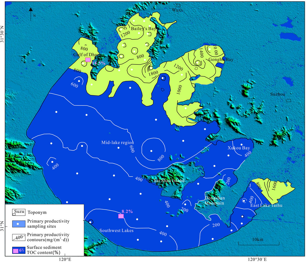
Figure 2. Spatial distribution of primary productivity in Taihu Lake, unit: mgC/(m2·d), based on data from Zhang et al. (2008).
The study found that smaller lake areas and shallower depths correspond to higher CBR [data mainly from Duan et al. (2008)]. Conversely, larger lake areas and greater depths result in wider lake surfaces, leading to lower CBR, with a five-fold difference observed between high and low values. It is concluded that lake CBR is inversely proportional to both area and water depth, a finding consistent with the conclusions of Ferland et al. (2012). This supports the carbon burial characteristics of lacustrine basins, aligning with the keywords “shallow” and “closed”. Downing et al. (2008) examined 40 small agricultural ponds in Iowa, United States, and found that the organic carbon burial rates in eutrophic agricultural ponds are significantly higher, by one to two orders of magnitude, than those in natural lakes or large reservoirs. This suggests that the organic carbon burial capacity of ponds worldwide may exceed that of the ocean. The underlying reason for this may be that larger areas receive less terrigenous organic debris, while smaller areas, characterized by more convoluted lakeshores or bay regions, receive more terrigenous organic matter, resulting in higher CBR. Qiao et al. (2023) conducted a study on lacustrine shale in the eastern Fukang Depression and found that lacustrine organic matter and aquatic macrophytes significantly contributed to the bacterial community, whereas algae made a comparatively smaller contribution. Liu et al. (2023) investigated the sources of organic matter in the lacustrine shale of the Dameigou Formation in the Qaidam Basin, concluding that lacustrine plants predominate.
Fossils discovered within lacustrine black shale formations also support the development of black shale in a shallow water environment.
The most suitable water depth for the leaf-limbed fossils is 1⁓20 cm, generally found in modern ponds, paddy fields, puddles, and similar environments, characterized by quiet water and small waves (low energy). In deeper water environments (>20 m), the fossil content is extremely low, making it an important index fossil. The living environment of bivalve fossils is slightly deeper, but they cannot develop in deeper water environments. Li et al. (2018) found that the benthic biota of Danjiangkou Reservoir was dominated by earthworms in the deep water area of Danjiangkou Reservoir (water depth >20 m); shallow water areas of Danjiangkou transition zone and Hanjiang transition zone (water depth <20 m) were primarily shelled mollusks. The former earthworms have no bones and shells, and it is difficult to preserve as fossils in the strata, while the latter are shelled mollusks, which will be preserved as bivalve fossils in the strata.
Bai et al. (2010) conducted through field observations and comprehensive research revealing that the Suhongtu Depression, located in the northern Yin’e Basin, is characterized by deep lake to semi-deep lake facies. The dark mudstone of the Bayingebi Formation K1b from the Lower Cretaceous exhibits a small single-layer thickness but a significant cumulative thickness, with few fossils present. In contrast, the shallow lake bay area near the basin’s edge is dominated by shale, which has a greater single-layer thickness and a smaller cumulative thickness. This oil shale is notable for its high oil content and abundance of fossils, particularly conchostracan fossils that indicate a shallow water environment (Figure 3). Although the deep lake to semi-deep lake mud in the northern part of the basin is thick and has a large cumulative oil shale thickness, it features a thin single-layer thickness and a low oil content of only 4.2%, rendering it unsuitable for industrial mining. In contrast, the southeastern shallow lake to semi-deep lake bay subfacies is rich in lobate structures. Despite its smaller cumulative thickness of oil shale, it possesses a large single-layer thickness and an oil content that reaches up to 6.9%, along with a wealth of conchostracan fossils.
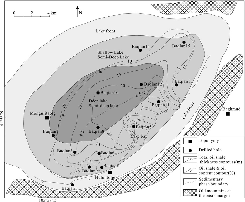
Figure 3. Plan map of oil shale distribution of the Bagmaode Formation (K1b2) of the Lower Cretaceous in the northeast end of the Suhongtu Depression, northern Yin’e Basin, central-western inner Mongolia, China. Modified from Bai et al. (2010).
The Jurassic Da’anzhai section in the Sichuan Basin developed lacustrine hydrocarbon source rocks, consisting of thick shale layers (Huang et al., 2018). Freshwater bivalves (including ostracods, conchostracans, and clam shrimp) were widely developed, and large-scale shell banks were deposited. Conchostracan fossils indicate a shallow, low-energy still water environment, where black, organic-rich mudstones and shales developed, with the presence of pyrite. Xu et al. (2020) conducted a comprehensive study of the Sichuan Basin, identifying the presence of shell beaches that indicate the development of shallow-water environments during this period.
In addition, conchostracan fossils can be found in almost all gas-rich shale layers in lacustrine basins. Examples include the Lower Cretaceous black shale of the Eedemt Formation, located in the Khootiin Khotgor Valley of Dundgobi Province, southeast Mongolia (Li et al., 2014), as well as the Cretaceous lacustrine shale of the Potiguar Basin in northeast Brazil (Lana and Carvalho, 2002), both of which contain conchostracan. The lacustrine shale of the Qing-1 member in the Songliao Basin is characterized by type I organic matter, with abundant ostracods, conchostracans and plant debris fossils (Ding et al., 2021); the Linxi Formation in the western edge of the Songliao Basin and the central and southern parts of the Greater Khingan Range is a terrestrial sedimentary structure containing bivalves, conchostracans and plant remains (Zhang et al., 2013).
Therefore, the development of conchostracan and bivalve fossils indicates that the lacustrine oil and gas-bearing shale layers developed in extremely shallow water environments, with water depths mostly less than 10–20 m, corresponding to the keyword “shallow.”
Coal seams are mainly developed in extremely shallow lake bays, swamps, and wetland environments. The classic coal-forming model is shown in Figure 4 (Guo et al., 2017). Coal seams develop in a lens-shaped manner from the edge of the lake basin to the center of the lake. Closer to the basin margin, the thickness of the coal seam tends to increase. However, as one moves gradually toward the sedimentary subsidence center of the basin, the thickness of the coal seams decreases until they pinch out, resulting in the formation of multiple vertically stacked coal lenticular bodies. Unless the basin is in the peneplain stage of late development, during which swampification occurs throughout the basin, coal seam may develop at the basin center, as illustrated in the Yimin Formation shown in Figure 4. If the edge of the basin maintains a peat swamp environment for a long time, it will form a horsetail-shaped similar to Figure 5 (Huang et al., 2011), with extremely thick coal seams developing toward the land end and pinching out toward the center of the lake basin. The proven reserves of the Shaerhu Coalfield (Figure 6), located at the southern margin of the Turpan-Hami Basin, rank first in China and also take the lead in Asia. The maximum thickness of an individual coal seam in this coalfield reaches 276 m. The ancient uplift area in the central part of the profile remained stable for an extended period, which facilitated the development of a swamp environment in the primary coal-producing area to the north. The white part at the tail of the horsetail-shaped coal seam indicates a small-scale lake transgression, where sand and mudstone are deposited, and then gradually silted up to form a swamp and coal, showing multiple cyclic characteristics. When the lake level rises, the swamp and wetland migrate away from the basin toward the land; when the lake level drops, they migrate closer to the center of the basin and develop multiple coal seams. The overlapping areas represent thick coal seams resulting from the continuous stacking of multiple coal seams. The Paleogene coal seams in the Fushun Basin also exhibit a similar horsetail-shaped distribution (Wu et al., 2001). The southern region is situated near the basin’s edge, with thickness diminishing towards the north as it approaches the center of the basin. A set of coal seams or coal lines corresponds to a local low-lying, low-energy, and low-water level environment within a basin. During the development of a basin, the depth of the aquatic environment in a region will not remain unchanged. Coal is an important depth indicator. As long as a coal seam appears, it is inevitably indicates a phase of paludification in shallow aquatic environments, serving as a crucial depth indicator.
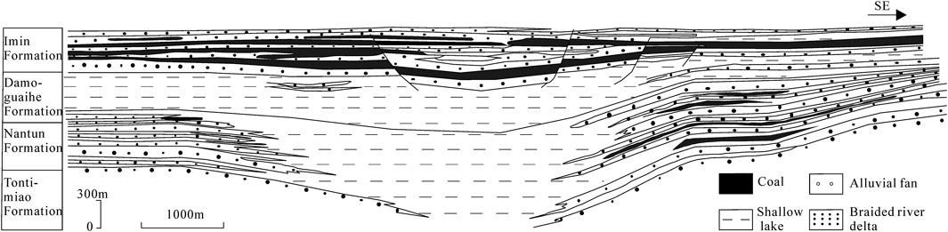
Figure 4. Sedimentary profile of the coal-bearing strata of the lower Cretaceous in the Yimin Sag. According to Guo et al. (2017).
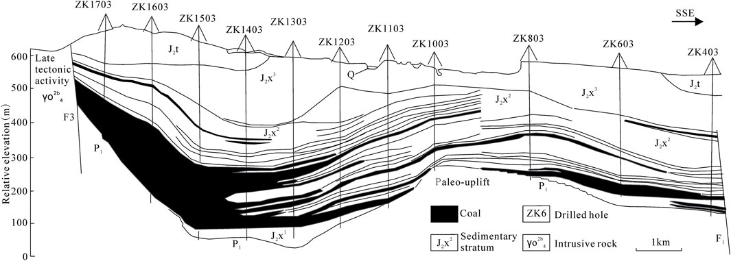
Figure 5. Profile of the coal seams in the Jurassic series in the eastern Shaerhu coalfield, southern margin of the Tuha basin. According to Huang et al. (2011).
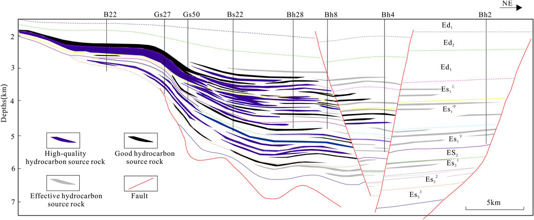
Figure 6. Profile of source rock development in the Oligocene Series of the Paleogene in the Qikou Sag (Jiang and Liu, 2015).
Dickinson (1976) was one of the earliest to observe a similar phenomenon in hydrocarbon distribution. Based on the oil and gas presence in 20 inland basins in the United States, he concluded that the distance from a basin to the nearest foreland fold-and-thrust belt determines hydrocarbon abundance, with oil reserves decreasing logarithmically as the distance increases. Langhorne et al. (2019) also concluded that the organic-rich Middle to Late Devonian Marcellus to Dunkirk black shales, commonly interpreted as being deposited in deeper, quieter, and long-term anoxic basins, were in fact deposited in relatively shallower environments.
In recent years, extensive exploration of shale oil and gas has demonstrated that the development of shale hydrocarbons follows patterns similar to those of coal. Organic-rich shale layers exhibit a feather-like distribution extending from the land towards deeper water, with the most developed layers located at the basin margins, thicker on the landward side and thinning towards the basin center. As illustrated in Figure 6, showing the hydrocarbon source rock comparison profile of the Qibei slope area and Qikou depression (Jiang and Liu, 2015), the main distribution areas of high-quality and thick hydrocarbon source rocks are not in the basin’s depositional center. A similar pattern is observed in the thickness distribution of oil shale in the western Qijia-Gulong depression of the Songliao Basin (Lu, 2017), where thick dark shale of the Qingshankou Formation is found on the landward (Western) side, thinning out towards the basin center. When combined with the aforementioned shale oil distribution in the Yin’e Basin, it becomes evident that the cross-sectional distribution patterns of shale gas, shale oil, and coal show a high degree of similarity.
Therefore, shale oil and gas share a similar mineralization model with coal, where the occurrence of high-quality hydrocarbon source layers and coal seams indicates the same depositional environmental characteristics. These layers represent a lower-energy, shallow-water lake bay subfacies (or interbay), which is deeper than the swamp environment where coal seams typically form, but not the deeper water, high-energy condensed or maximum flooding intervals. The depositional environment does not fall into the category of deep-lake or semi-deep-lake subfacies.
According to classical petroleum geology theory, fine-grained shale deposits and coal seams should form in entirely different depositional environments. From the swamp subfacies of the fluvial depositional system to the deep-lake subfacies of the lacustrine environment, multiple facies belts are traversed in between. Based on this, coal seams should not be in direct contact with black shale. However, when considering the lake bay subfacies within the lacustrine system, a continuous transition between these facies is possible, leading to an associated and direct contact relationship. Numerous cases illustrate the association between shale and coal or evaporites developed in shallow water environments. For example, in Fushun West Open-pit Mine, a thick oil shale is associated with long-flame coal, which has an oil content of around 10% in its lower part, with oil shale layers reaching a thickness of 48–190 m and an oil content of 6.6% (Fu et al., 2021). In the Upper Triassic Xujiahe Formation in Youyang and Banan, Chongqing, plant fossils and conchostracan fossils were found in association with coal seams (Liu et al., 2018).
Wang et al. (2016) systematically summarized five types of coal and oil shale symbiotic assemblages in terrestrial rift basins, concluding that both coal and oil shale contain higher plants and algae. From the lakeshore to the lake center, the coal seam thickness in these symbiotic assemblages gradually decreases. In the coal-oil shale symbiotic assemblages, the oil shale closer to the coal seam contains a higher proportion of higher plant components, while the coal seam closer to the oil shale contains a higher proportion of lower plants (algae), showing hydrogen enrichment. This reflects that the transition between coal and oil shale is continuous rather than abrupt, further proving their affinity and comparability.
Oil shale is also associated with evaporites and coal, as seen in the Wulidui Formation of the Eocene in the Tongbai Basin, Henan, where oil shale is interbedded with evaporites (Figure 7). In the Green River Basin, United States, oil shale, evaporites, and coal are interlayered (Tänavsuu-milkeviciene et al., 2017), and in the Fushun Basin, Liaoning, coal and oil shale are associated, evolving into evaporative dolomitic mudstone in the West Open-pit Formation (Xu et al., 2012).
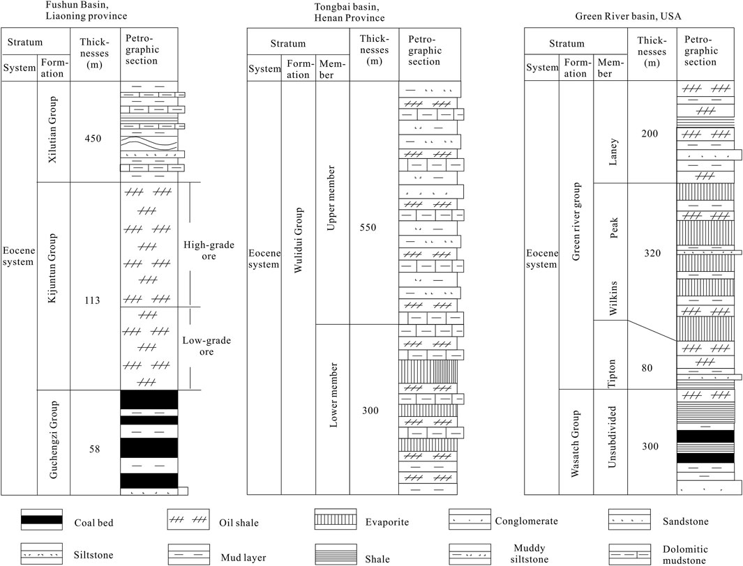
Figure 7. Coexistence phenomenon of shale with coal and evaporate, according to Xu et al. (2012).
Therefore, the widespread phenomenon of oil shale coexisting with coal and evaporites indicates that shallow water environments are more conducive to the accumulation of organic matter.
The aforementioned inference may raise a question: if it is indeed a shallow water environment, then the type of organic matter in the shale should primarily be Type III or Type II. So how can it be explained that many shale layers are Type I? In fact, this is a misconception. To clarify this, the organic matter types and gas content of major lacustrine shale formations in China were statistically analyzed, as shown in Table 1. From the table, it can be seen that Type I organic matter in lacustrine shale is relatively rare, with Type III and Type II being the most common. Thus, from the perspective of organic matter types in shale layers, there is no contradiction with the viewpoints proposed in this study.

Table 1. Statistical table of organic matter types and gas content in lacustrine shale formations.
Based on the above evidence, we can conclude that most organic-rich intervals in lacustrine shales developed in such restricted lacustrine environments as shallow lake bays. Restricted lacustrine environments provide sufficient conditions for the accumulation of organic matter.
Based on the aforementioned characteristics of lacustrine hydrocarbon source rocks—shallow, landward, and closed—it is possible to effectively explain the strong lateral heterogeneity in the development of lacustrine shale. Generally, the conditions for the formation of the depositional environment in lake bays or interbays are relatively strict. When the lake level rises, the bay becomes fully connected to the open aquatic environment, transitioning into an open aquatic system, in which organic matter can no longer be effectively accumulated. However, once a lake bay is formed, it can accumulate organic matter due to its small area, resulting in the “nest-like” deposits commonly observed in geological and mineral exploration. In actual exploration, it is also rare to find high-quality hydrocarbon source layers with good continuity and stable thickness distribution in the center of the lake basin. This explains the heterogeneity of organic-rich lacustrine shale.
Taking the Late Ordovician-Early Silurian Wufeng-Longmaxi Formation black shales in the Upper Yangtze region as an example, although this shale formation is often referred to as a product of the transgression stage in a deep-water continental shelf, multiple lines of evidence actually indicate that the region was a closed freshwater lagoon isolated from the open sea (Mao et al., 2023). Due to the large area of the Upper Yangtze, the organic matter accumulation in the lagoon’s depositional center, such as Luzhou and Chongqing, was much lower than at the basin margins, and the high-gas-production areas were limited to localized regions such as Weiyuan and Changning. The closer the shale is to the Central Sichuan Paleoland, the higher the TOC and gas production (Shi et al., 2023). Even within the small area of Changning, there is significant heterogeneity, with the sedimentary paleogeomorphology of the Longmaxi Formation displaying a pattern of alternating uplift and depression. The paleouplift areas are more favorable for hydrocarbon generation in high-quality shale compared to the paleovalleys (Wei et al., 2023).
It should be noted that the five pieces of evidence presented earlier in this section, which illustrate the environments conducive to organic matter enrichment in lacustrine shales, have not taken climatic factors into account. This omission may limit the applicability of the findings of this study. While it is currently widely accepted that high primary productivity is more favorable for organic matter enrichment in warm climatic conditions, recent research indicates that cold and wet climates may actually facilitate greater accumulation of organic matter (Mao et al., 2024). Due to space constraints, the relationship between the enrichment patterns of organic matter in shales and climate will be addressed as a potential direction for future research.
This paper applies the above approach to study the organic matter enrichment patterns in several faulted depressions of the Songliao Basin, confirming the conclusion that organic-rich shales develop in lake bay environments.
In the southern Songliao Basin, the first member of the Lower Cretaceous Yingcenzi Formation and the second member of the Shahezi Formation in the Lishu Fault Depression are the main hydrocarbon source rocks in this area. These formations consist of black mudstones, dark gray mudstones, and are rich in conchostracan fossils, with kerogen types being Type II and Type III. The first member of the Yingcenzi Formation contains a significant distribution of conchostracan fossils and higher plant fragments (Ni, 2021). As shown in Figures 8A, B, conchostracan fossils were observed in Well L1 of the first member of the Yingcenzi Formation in the Sujiatun area in the northwest of the Lishu Fault Depression, indicating deposition in a shallow water environment. During the Early Cretaceous, the Sujiatun area represented a semi-closed lake bay, separated by a northeast-southwest trending paleouplift in the eastern Sujiatun area, forming a semi-closed bay approximately 5 ∼ 6 km wide (Figure 9), which was rich in organic matter. The TOC distribution map of the second member of the Shahezi Formation (Figure 9) shows that Well L2 in the eastern part of the region was also located in a semi-closed lake bay environment. This well also exhibited good shale gas indications, with conchostracan fossils observed in shallow layers (Figure 8C). Additionally, the map shows that in the southern part of the Lishu Fault Depression, the J1 well area, and the northeastern S167, S119, and N2 well areas, closed or semi-closed lake bays were formed, rich in organic matter, which migrated vertically into the sand bodies at the top of the Yingcenzi Formation to form conventional oil and gas reservoirs such as Jinshan Gas Field, Shiwu Oil Field, Qikeshui Oil Field, and Shuanglong Oil Field.
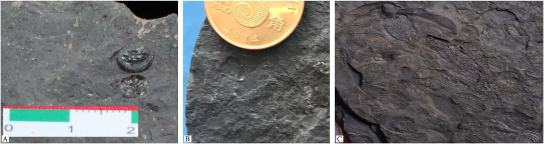
Figure 8. Conchostracan fossils from Ying⁃1 member of Lower Cretaceous in Lishu Fault Depression. (A) Well L2, 3,165.67 m; (B) Well L2, 3,146.21 m; (C) Well L1, 3,241.15 m.
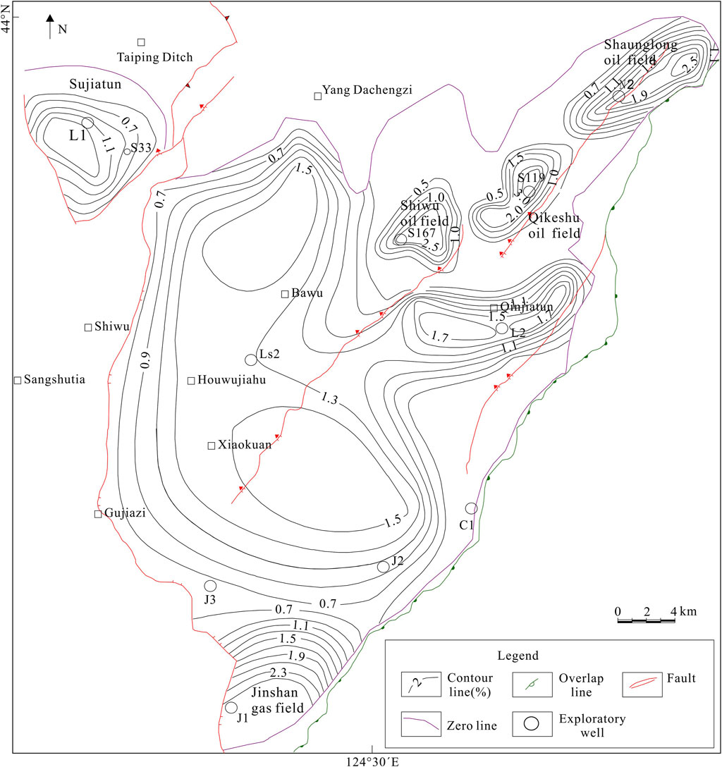
Figure 9. TOC distribution of source rocks in the second member of Shahezi Formation in Lishu Fault Depression, southern Songliao basin.
Not far from the Lishu Fault Depression, in the Longfengshan area of the southern Songliao Fault Depression, the Shahezi Formation shale also contains conchostracan fossils, which represent a shallow water environment. The relationship between organic matter abundance and the depositional center is shown in Figure 10. The Sha 2-2 section of Wells B203 and B208, located closer to the center of the lake basin, consists of multiple interbedded sand and mud layers, as shown in Figure 11. The sand bodies originated from the southwest delta front due to rapid sediment supply. In contrast, Wells B217, B216, and B212, located in the southeastern part near the basin margin, developed thick, organic-rich shale layers, forming a semi-closed lake bay in a shallow water, low-energy environment. From the edge of the basin towards its center (from B217 to B208 and B203), this area corresponds to the slope zone of the basin based on the modern basin structure. However, when applying tectonic history restoration, it becomes apparent that during the deposition period of the Shahezi Formation, the region surrounding Well B217 was characterized by a restricted lacustrine environment. The deeper burial of the Shahezi Formation in Wells B208 and B203 is due to later basin development and sedimentary subsidence. Therefore, the assumption that black shale developed during the maximum flooding period is clearly untenable.
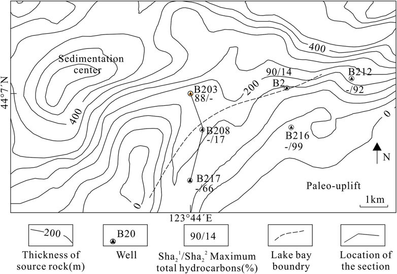
Figure 10. Thickness plan of source rocks in the Longfengshan fault depression.

Figure 11. Multi-well tie section connecting wells B217-B208-B203 in the Longfengshan Fault Depression.
In the southern Songliao region, there are also occurrences of black shale associated with coal. For example, in the Xujiaweizi Fault Depression in the northern part, the Shahezi Formation has developed four sequences of coal-bearing hydrocarbon source rocks and dark mudstone organic matter in the vertical profile (Jiang et al., 2024). The southeastern margin of the Songliao Basin has formed abundant coal resources. The main coal seams are developed in the first and second members of the Hezi Formation (Shao et al., 2020), in association with black shale.
Based on the study of modern sedimentary environments and comparative analysis between black shale and coal, this study draws the following conclusions. (1) The condensed section during the maximum flooding surface interval is organically poor, and effective burial of organic matter is difficult in deep-water lake environments. (2) The most organic-rich intervals of lacustrine shale layers developed in closed or semi-closed aquatic environments such as lake bays and swamps; the development of each shale oil and gas layer indicates that the basin was in a shallow water environment at the time, serving as an indicator of water depth or environmental conditions, similar to coal. (3) The necessary condition for organic matter enrichment in shale formations is being situated in relatively shallow water, while the sufficient condition is an closed or semi-closed water environment. (4) The organic-rich shales in the Lishu Fault Depression and Longfengshan Fault Depression developed in relatively small lake bay environments. The heterogeneity of lacustrine shale reservoirs can be attributed to four key factors: shallow, landward, closed, and cold depositional environments.
This study effectively elucidates the mechanisms underlying heterogeneity in lacustrine shale development and potentially provides new insights for future lacustrine shale oil and gas exploration. In the search for optimal locations for shale oil and gas, greater emphasis should be placed on the contributions of terrigenous organic matter and the relatively closed, shallow-water environments found in lake bays.
The original contributions presented in the study are included in the article/supplementary material, further inquiries can be directed to the corresponding author.
XM: Conceptualization, Data curation, Formal Analysis, Funding acquisition, Investigation, Methodology, Project administration, Resources, Writing–original draft, Writing–review and editing. XC: Resources, Software, Supervision, Validation, Visualization, Writing–review and editing. YY: Data curation, Investigation, Resources, Visualization, Writing–review and editing. QZ: Formal Analysis, Validation, Investigation, Writing–review and editing.
The author(s) declare that financial support was received for the research, authorship, and/or publication of this article. This study was financially supported by State Energy Key Laboratory for Carbonate Oil and Gas, No. 33550000-24-ZC0613-0105), PhD Program of Guilin University of Aerospace Technology, No. KX202307701, and the Key Fund Projects, No. 42230816.
The authors declare that the research was conducted in the absence of any commercial or financial relationships that could be construed as a potential conflict of interest.
The author(s) declare that no Generative AI was used in the creation of this manuscript.
All claims expressed in this article are solely those of the authors and do not necessarily represent those of their affiliated organizations, or those of the publisher, the editors and the reviewers. Any product that may be evaluated in this article, or claim that may be made by its manufacturer, is not guaranteed or endorsed by the publisher.
Bai, W. H., Wu, Y. B., Gao, Z. L., and Sun, S. S. (2010). Study on the mechanism of oil shale minerogenetic enrichmen in the arm of shallow to half-deep lake depositional environment. Geol. Surv. Res. 33 (3), 207–214. (in Chinese with English abstract).
Benjamin, A. S., Van, M., Richard, G. K., and Allan, H. D. (2002). Impact of suboxia on sinking particulate organic carbon: enhanced carbon flux and preferential degradation of amino acids via denitrification. Geochimica Cosmochimica Acta 66 (3), 457–465. doi:10.1016/S0016-7037(01)00787-6
Boyd, P. W., and Newton, P. P. (1999). Does planktonic community structure determine downward particulate organic carbon flux in different oceanic provinces? Deep Sea Res. Part I Oceanogr. Res. 46 (1), 63–91. doi:10.1016/S0967-0637(98)00066-1
Bruhn, C. H. (1999). Reservoir architecture of deep-lacustrine sandstones from the Early Cretaceous Reconcavo rift basin, Brazil. AAPG Bull. 83, 1502–1525. doi:10.1306/e4fd41f7-1732-11d7-8645000102c1865d
Chen, L., Jiang, Z. X., Liu, K. Y., Wang, P. F., Ji, W. M., Gao, F., et al. (2016). Effect of lithofacies on gas storage capacity of marine and continental shales in the Sichuan Basin, China. J. Nat. Gas Sci. Eng. 36 (A), 773–785. doi:10.1016/j.jngse.2016.11.024
Dickinson, W. R. (1976). “Plate tectonic evolution of sedimentary basin,” in Plate tectonics and hydrocarbon accumulation. AAPG continuing Education Course note series. Editors W. R. Dickinson, and H. Yarborough (Tulsa), 1, 1–63.
Ding, C., Sun, P. C., Rexiti, Y. L. K., Wang, C., Zhang, Y., Zhang, Q., et al. (2021). Classification and genesis of fine-grained sedimentary rocks of Qingshankou Formation in Songliao Basin. Xinjiang Pet. Geol. 42 (4), 418–427. (in Chinese with English abstract). doi:10.7657/XJPG20210404
Downing, J. A., Cole, J. J., Middelburg, J. J., Striegl, R. G., Duarte, C. M., Kortelainen, P., et al. (2008). Sediment organic carbon burial in agriculturally eutrophic impoundments over the last century. Glob. Biogeochem. Cycles 22 (1), GB1018–1. doi:10.1029/2006GB002854
Duan, X. N., Wang, X. K., Lu, F., and Ouyan, Z. Y. (2008). Primary evaluation of carbon sequestration potential of wetlands in China. Acta Ecol. Sin. 28 (2), 463–469. (in Chinese with English abstract). doi:10.1016/s1872-2032(08)60025-6
Fei, Z. L., Mao, X. H., Zhu, M. Y., Li, B., Guan, Y. H., Zhang, X. S., et al. (1988). Studies on the productivity of the Bohai sea Ⅱ. Estimation of primary productivity and potential fishing yield. Acta Oceanol. Sin. 10 (4), 481–489. (in Chinese with English abstract).
Ferland, M. E., Giorgio, P. A. D., Teodoru, C. R., and Prairie, Y. T. (2012). Long-term C accumulation and total C stocks in boreal lakes in northern Quebec. Glob. Biogeochem. Cycle 26, 1∼10. doi:10.1029/2011GB004241
Fu, C., Ding, H., and Chen, W. M. (2021). Resources distribution and comprehensive utilization of oil shale and coal symbiosis in China. Coal Qual. Technol. 36 (3), 1–13. (in Chinese with English abstract).
Galloway, W. E. (1989). Genetic stratigraphic sequence in basin analysis l: architecture and genesis of flooding-surface bounded depositional units. AAPG Bull. 73, 125–142. doi:10.1306/703C9AF5-1707-11D7-8645000102C1865D
Gemaison, G. J., and Moore, G. T. (1980). Anoxic environments and oil source bed genesis. AAPG Bull. 64, 1179. doi:10.1306/2f91945e-16ce-11d7-8645000102c1865d
Guo, B., Shao, L. Y., Ma, S. M., and Zhang, Q. (2017). Coal–accumulating and coal-forming patterns within sequence stratigraphy framework of early cretaceous in hailar basins. Coal Geol. & Explor. 45 (1), 14–19. (in Chinese with English abstract). doi:10.3969/j.issn.1001-1986.2017.01.003
He, J. L., Chen, Z. H., Dong, D. Z., Sun, S. S., and Wang, Z. G. (2022). The evolution of sedimentary environments of dongyuemiao member and key factors for enrichment of shale oil and gas, northeastern Sichuan Basin. Sediment. Geol. Tethyan Geol. 42 (3), 385–397. (in Chinese with English abstract). doi:10.19826/j.cnki.1009-3850.2022.05001
Hou, H. H., Shao, L. Y., Li, Y. H., Liu, L., Liang, G. D., Zhang, W., et al. (2022). Effect of paleoclimate and paleoenvironment on organic matter accumulation in lacustrine shale: constraints from lithofacies and element geochemistry in the northern Qaidam Basin, NW China. J. Petroleum Sci. Eng. 208 (PA), 109350. doi:10.1016/j.petrol.2021.109350
Huang, D., Duan, Y., Li, Y. C., Chen, H. B., Yan, W. P., Dai, H. M., et al. (2018). Study on the TOC lower limit of shale oil and gas of freshwater lake facies: a case study on the jurassic Da’anzhai member in the Sichuan Basin. China Pet. Explor. 23 (6), 38–45. (in Chinese with English abstract). doi:10.3969/j.issn.1672-7703.2018.06.005
Huang, T. D., Wang, P., Li, H., Chen, J., Zhou, H., Wei, X., et al. (2011). The analysis of heterotopic formation about extremely-thick coal seam in Shaerhu coalfield. Xinjiang Geol. 29 (3), 324–326. (in Chinese with English abstract). doi:10.3969/j.issn.1000-8845.2011.03.015
Jiang, H. F., Ai, X., Luo, G. D., Geng, C. X., Wang, Y. Z., Li, Z. B., et al. (2024). Hydrocarbon accumulation mechanism and exploration breakthrough of deep tight gas in the cretaceous Shahezi Formation in Xujiaweizi Fault Depression, Songliao Basin. China Pet. Explor. 29 (1), 130–141. doi:10.3969/j.issn.1672-7703.2024.01.010
Jiang, S., Tang, X. L., Osborne, S., and Anderson, T. (2017). Enrichment factors and current misunderstanding of shale oil and gas: case study of shales in U.S., Argentina and China. Earth Sci. 42 (7), 1083–1091. (in Chinese with English abstract). doi:10.3799/dqkx.2017.087
Jiang, W. Y., and Liu, S. (2015). Distribution and controlling factors of high-quality hydrocarbon source rock in sequential stratigraphic framework—taking Paleogene system in Qikou depression for instance. China Pet. Explor. 20 (2), 51–58. (in Chinese with English abstract). doi:10.3969/j.issn.1672-7703.2015.02.006
Lana, C. C., and Carvalho, I. D. S. (2002). Cretaceous conchostracans from potiguar basin (northeast Brazil): relationships with west african conchostracan faunas and palaeoecological inferences. Cretac. Res. 23, 351–362. doi:10.1006/cres.2002.1007
Langhorne, B. S., Juergen, S., and Ryan, D. W. (2019). Shallow-water onlap model for the deposition of Devonian black shales in New York, USA. Geology 47 (3), 279–283. doi:10.1130/G45569.1
Li, B., Zhang, M., and Cai, Q. H. (2018). Spatial distribution of macrobenthic secondary production of Danjiangkou Reservoir. Asian J. Ecotoxicol. 13 (4), 22–29. (in Chinese with English abstract). doi:10.7524/AJE.1673-5897.20180413001
Li, G., Ando, H., Hasegawa, H., Yamamoto, M., Hasegawa, T. A., Ohta, T. O., et al. (2014). Confirmation of a Middle Jurassic age for the Eedemt Formation in Dundgobi Province, southeast Mongolia: constraints from the discovery of new spinicaudatans (clam shrimps). Alcheringa Australas. J. Palaeontol. 38 (3), 305–316. doi:10.1080/03115518.2014.870834
Li, H., Huang, B. Q., and Wang, N. (2017). Changes of the palaeo-sea surface productivity and bottom water dissolved oxygen content at MD12-3429, northern South China sea. Acta Palaeontol. Sin. 56 (2), 238–248. (in Chinese with English abstract).
Liu, B., Wang, H. L., Fu, X. F., Bai, Y. F., Bai, L. H., Jia, M. C., et al. (2019). Lithofacies and depositional setting of a highly prospective lacustrine shale oil succession from the Upper Cretaceous Qingshankou Formation in the Gulong sag, northern Songliao Basin, northeast China. AAPG Bull. 103 (2), 405–432. doi:10.1306/08031817416
Liu, Q. Q., Chi, Q. H., Wang, X. Q., Zhou, J., Liu, H. L., Liu, D. S., et al. (2018). Distribution and influencing factors of rare Earth elements in carbonate rocks along three continental-scale transects in eastern China. Earth Sci. Front. 25 (4), 99–115. (in Chinese with English abstract). doi:10.13745/j.esf.yx.2017-12-28
Liu, S. M., Jiang, L., Liu, B. J., Zhao, C. L., Tang, S. H., and Tan, F. (2023). Investigation of organic matter sources and depositional environment changes for terrestrial shale succession from the Yuka depression: implications from organic geochemistry and petrological analyses. J. Earth Sci. 34 (5), 1577–1595. doi:10.1007/s12583-022-1617-1
Lu, J. (2017). Fine sedimentary cycles and heterogeneity of Qingshankou Formation in gulong Sag, Songliao Basin (NE China) (Dissertation). Daqing: Northeast Petroleum University. (in Chinese with English abstract).
Mao, X. P., Chen, X. R., Li, Z., Li, S. X., Li, S. S., Zhu, Q. X., et al. (2023). A review of depositional patterns and organic matter enrichment patterns of Wufeng∼Longmaxi Formation shales in the Sichuan Basin. J. Sedimentology 1∼46. doi:10.14027/j.issn.1000-0550.2023.060
Mao, X. P., Chen, X. R., Wang, Z. J., Yang, Y. X., Li, S. X., Yang, F., et al. (2024). Relationship between organic matter enrichment degree of black shale and paleoclimate:Taking the shale of the Wufeng-Longmaxi Formation in the middle and upper Yangtze region as an example. Chin. J. Geol. Geol. Sinica, 1–25. doi:10.12017/dzkx.2024.081
Ni, D. M. (2021). Geological features of continental shale reservoir in lishu fault depression of songliao Basin. Unconv. Oil & Gas, 8(3): 33–42 (in Chinese with English abstract). doi:10.19901/j.fcgyq.2021.03.05
Qiao, J. Q., Luo, Q. Y., Zhang, Y., Wang, D. D., Cui, H., Shang, X. Q., et al. (2023). Formation conditions and enrichment mechanisms of the Jurassic lacustrine organic-rich shale in the East Fukang Sag, Junggar Basin, NW China: a reassessment based on organic geochemistry. Front. Earth Sci. 11. doi:10.3389/feart.2023.1086827
Shao, K., Shao, L. Y., Ma, D. M., Wang, D. D., Wang, S., and Gao, D. (2020). A study of sequence stratigraphy of the Early Cretaceous coalbearing series in the southeastern Songliao Basin, NE China. Int. J. Coal Sci. & Technol. 7 (2), 263–272. doi:10.1007/s40789-020-00339-8
Shi, Z. S., Wang, H. Y., Zhao, S. X., Zhou, T. Q., Zhao, Q., Qi, L., et al. (2023). Rapid transgressive black shale characteristics and organic matter distribution of the Lower Silurian Longmaxi shale in southern Sichuan Basin, China. J. Palaeogeogr. (ChineseEdition) 25 (4), 788–805. doi:10.7605/gdlxb.2023.04.065
Sun, L., Wu, S. H., Yue, D. L., Jiang, S. C., Xiao, K., Li, X. B., et al. (2024). Mineralogical and geochemical characteristics of mudstones from the Lower Cretaceous Prosopis Formation in the Bongor basin, Chad: implications for provenance, paleoenvironment and organic matter enrichment. Mar. Petroleum Geol. 168, 107031. doi:10.1016/j.marpetgeo.2024.107031
Tait, R. V. (1981). Elements of marine ecology an introductory course. 3rd Edition. London: Butterworths & Co. (Publishers) Ltd., 207–218. doi:10.1086/406209
Tänavsuu-milkeviciene, k., Sarg, J. F., and Bartov, Y. (2017). Depositional cycles and sequences in an organic-rich lake basin: Eocene Green River formation, lake Uinta, Colorado and Utah, USA. J. Sediment. Res. 87 (3), 210–229. doi:10.2110/jsr.2017.11
Tang, Y., Yang, R. Z., Yin, S., Fan, T. L., Dong, L. F., and Hou, Y. C. (2018). Analysis of continental shale gas accumulation conditions in a rifted basin: a case study of Lower Cretaceous shale in the southern Songliao Basin, northeastern China. Mar. Petroleum Geol. 101, 389–409. doi:10.1016/j.marpetgeo.2018.12.002
Wang, D. D., Li, Z. X., Lü, D. W., Liu, H. Y., Wang, P. L., and Feng, T. T. (2016). Coal and oil shale paragenetic assemblage and sequence stratigraphic features in continental faulted basin. Earth Sci. 41 (3), 508–522. (in Chinese with English abstract). doi:10.3799/dqkx.2016.042
Wei, G. D., Tan, X. C., Liu, R., Zhang, K. B., Zhen, J., and Li, H. (2023). The coupling mechanism between geomorphology of shale sedimentary and differential enrichment of shale gas in Longmaxi Formation in Changning area. Sediment. Geol. Tethyan Geol., 1–14. doi:10.19826/j.cnki.1009-3850.2022.12005
Wu, C. L., Wang, X. Q., Liu, G., Li, S. H., Mao, X. P., and Li, X. (2001). Tectonic evolution dynamics of Fushun Basin. Sci. China (Ser D) 31 (6), 477–485. (in Chinese). doi:10.3321/j.issn:1006-9267.2001.06.006
Wu, F., Zhan, J. Y., Deng, X. Z., and Lin, Z. Y. (2012). Influencing factors of lake eutrophication in China—a case study in 22 lakes in China. Ecol. Environ. Sci. 21 (1), 94–100. (in Chinese with English abstract).
Wu, Z. R., Littke, R., Baniasad, A., Yang, Z., Tang, Z. X., and Grohmann, S. (2023). Geochemistry and petrology of petroleum source rocks in the upper cretaceous Qingshankou Formation, Songliao Basin, NE China. Int. J. Coal Geol. 270, 104222. doi:10.1016/j.coal.2023.104222
Xie, M., and Guo, S. B. (2024). Study on the relationship between shale organic matter development and paleowater depth—a new understanding of the condensed section. Mar. Petroleum Geol. 169, 107076. doi:10.1016/j.marpetgeo.2024.107076
Xu, Q. L., Hao, F., Ma, Y. S., Liu, B., and Song, X. M. (2020). Effects of the matrix on the oil production of supertight limestone in a lacustrine mixed sedimentary environment: the case of the jurassic da'anzhai member in the central sichuan basin, china. Mar. Petroleum Geol. 121 (104583), 104583–104623. doi:10.1016/j.marpetgeo.2020.104583
Xu, S. C., Liu, Z. J., Dong, Q. S., Chen, H. J., and Liu, R. (2012). Deposition and sedimentary evolution of coal, oil shale and evaporite-bearing strata in terrestrial basins. J. Jilin Univ. Earth Sci. Ed. 42 (2), 296–303. (in Chinese with English abstract). doi:10.3969/j.issn.1671-5888.2012.02.002
Yang, Z., Zou, C. N., Wu, S. T., Pan, S. Q., Wang, X. N., Liu, H., et al. (2022). Characteristics, types, and prospects of geological sweet sections in giant continental shale oil provinces in China. J. Earth Sci. 33 (5), 1260–1277. doi:10.1007/s12583-022-1735-9
Yu, Y., Liu, D. F., Yang, Z. J., Zhang, J. L., Xu, Y. Q., Liu, J. G., et al. (2017). Vertical stratification characteristics of dissolved oxygen and phytoplankton in thousand-island lake and their influencing factors. Environ. Sci. 38 (4), 1393–1402. (in Chinese with English abstract). doi:10.13227/j.hjkx.201606085
Zhang, J., Bian, X. F., Chen, S. W., Zhen, Y. J., Tang, Y. J., and Jiang, X. C. (2013). Shale gas resources prospect of late Permian Linxi Formation in the middle-southern part of the Da Hinggan Mountains. Geol. Bull. China 32 (8), 1297–1306. (in Chinese with English abstract). doi:10.3969/j.issn.1671-2552.2013.08.017
Zhang, J. C., Jin, Z. J., and Yuan, M. S. (2004). Reservoiring mechanism of shale gas and its distribution. Nat. Gas. Ind. 24 (7), 131–132. (in Chinese with English abstract). doi:10.3321/j.issn:1000-0976.2004.07.005
Zhang, P., Xu, Y., Meng, Q., Liu, Z., Zhang, J., Shen, L., et al. (2020). Sequence stratigraphy and geochemistry of oil shale deposits in the upper cretaceous Qingshankou Formation of the Songliao Basin, NE China: implications for the geological optimization of in situ oil shale conversion processing. Energies 13 (11), 2964. doi:10.3390/en13112964
Zhang, Y. L., Feng, S., Ma, R. H., Liu, M. L., and Qin, B. Y. (2008). Spatial pattern of euphotic depth and estimation of phytoplankton primary production in lake Taihu in Autumn 2004. J. Lake Sci. 20 (3), 380–388. (in Chinese with English abstract). doi:10.18307/2008.0319
Zhou, T. X., Luo, W. L., Da, J., Wu, Q., Yu, C. Y., and Huabing, L. (2022). Spatial distribution of Bacterioplankton community composition and their diversity in lake Fuxian during thermal stratification period. J. Lake Sci. 34 (5), 1642–1655. (in Chinese with English abstract). doi:10.18307/2022.0518
Keywords: shale gas, hydrocarbon source bed, lake bay, maximum flooding period, leaf limb medium, primary productivity, depositional environment, redox conditions
Citation: Mao X, Chen X, Yang Y and Zheng Q (2025) Controls on organic matter enrichment and reservoir heterogeneity in lacustrine shales: insights from the Songliao Basin, NE China. Front. Earth Sci. 13:1511598. doi: 10.3389/feart.2025.1511598
Received: 15 October 2024; Accepted: 14 February 2025;
Published: 18 March 2025.
Edited by:
Wenbin Tang, Chengdu University of Technology, ChinaReviewed by:
Xiaogang Ma, University of Idaho, United StatesCopyright © 2025 Mao, Chen, Yang and Zheng. This is an open-access article distributed under the terms of the Creative Commons Attribution License (CC BY). The use, distribution or reproduction in other forums is permitted, provided the original author(s) and the copyright owner(s) are credited and that the original publication in this journal is cited, in accordance with accepted academic practice. No use, distribution or reproduction is permitted which does not comply with these terms.
*Correspondence: Mao Xiaoping, bWFveHBAY3VnYi5lZHUuY24=
Disclaimer: All claims expressed in this article are solely those of the authors and do not necessarily represent those of their affiliated organizations, or those of the publisher, the editors and the reviewers. Any product that may be evaluated in this article or claim that may be made by its manufacturer is not guaranteed or endorsed by the publisher.
Research integrity at Frontiers
Learn more about the work of our research integrity team to safeguard the quality of each article we publish.