
94% of researchers rate our articles as excellent or good
Learn more about the work of our research integrity team to safeguard the quality of each article we publish.
Find out more
ORIGINAL RESEARCH article
Front. Earth Sci. , 26 February 2025
Sec. Georeservoirs
Volume 13 - 2025 | https://doi.org/10.3389/feart.2025.1481538
 Haitao Liu1
 Yan Chen1,2*Jufeng Wang1Deqiang Sun3Zijun Tang1Chunming Zhang1Fengcheng Wu1Zhenglong Jiang2
As an important oil and gas exploration target area in continental rift basins, the sedimentary bodies in the steep slope zone are mainly composed of glutenite, featuring proximal and rapid accumulation, forming glutenite reservoirs with high porosity and permeability, which are conducive to the storage of oil and gas. The activities of boundary faults not only control the spatial structure of the basin but also affect the material source supply, paleogeomorphic morphology and the changes in the accommodation space within the basin. Through the study of the Nanpu and Banqiao trough areas and the Cangdong - Xi’nanzhuang - Baigezhuang steep slope zone in the Huanghua Depression, the influence of the supply capacity, groove transport flux and the structural form of the catchment area on the development scale of the glutenite fan bodies is discussed in detail. The research shows that the glutenite bodies in the steep slope zone are adjacent to the hydrocarbon-generating depression, forming a good source-reservoir contact hydrocarbon supply mode, presenting a deep adjacent-source reservoir-forming structure, with superior reservoir-forming conditions and the characteristics of being prone to forming lithologic oil and gas reservoirs; the Xi’nanzhuang steep slope zone is a multi-layer adjacent-source reservoir-forming structure, with equally superior reservoir-forming conditions, which can form both lithologic and structural oil and gas reservoirs; while the Baigezhuang steep slope zone, due to its relatively far distance from the hydrocarbon-generating depression, shows the characteristics of multi-layer far-source reservoir formation, with relatively poor reservoir-forming conditions, and is more inclined to form structural oil and gas reservoirs. Through the division of different structural styles such as shovel-shaped, slope-flat type and fault-step type steep slope zones and the in-depth analysis of their sand control and reservoir control mechanisms, the decisive role of factors such as fault activities, paleogeomorphology and material source supply on the development of glutenite fan bodies and the reservoir-forming rules of oil and gas in the steep slope zone has been clarified, which provides strong geological theoretical support for further improving the exploration efficiency and reserve prediction of glutenite oil and gas reservoirs in the steep slope zone of the Bohai Bay Basin.
As a reservoir with high porosity and permeability, glutenite bodies have been recognized in global oil and gas exploration. For example, the Niger Delta sandstone reservoir in Africa (Osinowo et al., 2018), the Nile Delta glutenite reservoir (Eysa et al., 2024), the glutenite reservoir in Norway (Dooley et al., 2003), the fan delta glutenite reservoir in the Pannonian Basin in central Europe (Mallarino et al., 2022), and the conglomerate reservoir in the Garfield field in Kansas, USA (Rogers, 2007). The steep slope zone developed along the boundary fault is an important area for oil and gas exploration in continental rift basins. The sedimentary bodies in the steep slope zone are characterized by proximal source and rapid accumulation. The typical sedimentary body widely developed is the fan delta glutenite body (Mallarino et al., 2022), which is composed of coarse clastic materials such as conglomerate, glutenite, pebbly sandstone, and conglomeratic sandstone, forming thick and large-scale glutenite reservoirs, which are ideal reservoir media for oil and gas (Zhu et al., 2018; Liu et al., 2019; Yang et al., 2022). As of 2024, based on literature retrieval, although this type of reservoir is distributed around the world, due to the influence of the current status of oil and gas exploration in various countries, currently, only in China has the exploration and research developed the fastest with the most research results. Among them, the published literature in the Bohai Bay Basin of China is the richest. The activity and evolution of the boundary fault directly affect the spatial configuration of the basin and have a profound impact on the sediment supply in the source area, the paleogeomorphology, and the change of accommodation space in the basin (Gawthorpe and Leeder, 2000; Deibert and Camilleri, 2006; Chen H. et al., 2024; Chen Y. et al., 2024). The complex fault activities and paleogeomorphology in the rift basin often lead to strong differences in the spatio-temporal distribution of the steep slope zone, which is not conducive to the accurate prediction of the sand bodies in the steep slope zone. In the field of sedimentology, slopes with a gradient less than 1° are usually called gentle slopes, and slopes with a gradient greater than 5° are called steep slopes (Leeder, 1999; Miall, 2001). The steep slope zone described in this paper specifically refers to the secondary structural unit that transitions from the deep (subsag) zone to the bulge in the rift lacustrine basin, mainly referring to the supra-unconformity and denudation monocline zone connected to the bulge in the form of a steep slope (fault dip angle greater than 30°), including the relatively large fault near the boundary of the main trough in the sag to the edge of the bulge. Many scholars have carried out a series of corresponding studies on the reservoir performance and exploration prediction of the glutenite fans in the steep slope zone, and recognized that the boundary fault, tectonic evolution stage, paleo-uplift, and paleoclimate are the main controlling factors for the development of the glutenite bodies in the steep slope zone of the rift lacustrine basin (Wang et al., 2014; Zhu et al., 2018; Zhang et al., 2019; Deng et al., 2020; Chen et al., 2021; Liu et al., 2023; Zhong K. et al., 2024; Zhong Q. et al., 2024).
At present, studies on the structure, paleogeomorphology and other aspects of the steep slope zone are important ways to reveal the distribution of its fan bodies and their genetic mechanisms (Chen et al., 2021). Previous researchers took the steep slope zone of the Weixi’nan Sag in the South China Sea as the research object and believed that the structural styles of the steep slope zone could be divided into three types: shovel-shaped, slope-flat and fault-step (Liu et al., 2023). Based on the analysis of paleogeomorphology and source channel characteristics, some scholars pointed out the gully-fan correspondence relationship for the development of steep slope fan bodies (Fuller and Marden, 2008; Reitz and Jerolmack, 2012; Wang L. et al., 2021), and the distribution range of fan bodies was controlled by the scale and quantity of gullies. When scholars such as Jackson studied the turbidite system in the North Sea rift basin, they pointed out that fault structures such as shovel-shaped or plate-shaped controlled the shape and range of the subsidence center, and the gravitational flow sedimentation mechanism and the sedimentary distribution of sand bodies were mainly controlled by the changes of micro-geomorphology related to faults. When encountering a fault plane (whether shovel-shaped or plate-shaped), turbidity currents would experience a hydraulic jump due to the decrease in flow velocity, resulting in sediment unloading and deposition (Jackson et al., 2011). Scholars such as Deibert pointed out based on a simple half-graben model that the end of the boundary fault was a favorable location for the development of large gullies, which usually developed during low lake levels and were filled and preserved during high lake levels (Deibert and Camilleri, 2006). The development scale of steep slope fan bodies was also controlled by the type and supply amount of the source materials (Lyu and Song, 2022; Zhong K. et al., 2024; Zhong Q. et al., 2024). Therefore, clarifying the control effects of elements such as the source materials, paleogeomorphic forms, fault combination styles, and fault activity rates on the sedimentary characteristics and distribution patterns of fan bodies in the steep slope zone is the key to establishing the development model of steep slope fans.
At present, significant breakthroughs have been achieved in the exploration of oil and gas in glutenite bodies in the steep slope zone in both eastern, western China and the South China Sea: namely, in the Dongying Sag (Wang et al., 2014; Zhang et al., 2019; Yang et al., 2022), Chezhen Sag (Zhu et al., 2014; Room et al., 2023), Liaohe Sag and Liaodong Bay (Deng et al., 2020; Zhong K. et al., 2024; Zhong Q. et al., 2024), Shijiutuo Uplift (Chen et al., 2021), Bonan Uplift (Ma et al., 2015) and other areas in the Bohai Bay Basin in eastern China, Mahu Sag in the Junggar Basin in western China (Zhou et al., 2018; Zhou et al., 2021), Lufeng Sag (Zhong K. et al., 2024; Zhong Q. et al., 2024) and Weixi’nan Sag (Liu et al., 2023) in the Beibu Gulf Basin in the South China Sea, where billion-ton-level large oilfields have been discovered. From the perspective of literature retrieval, the exploration of oil and gas in the steep slope zone of the Dongying Sag and the Chezhen Sag in the Bohai Bay Basin has reached a relatively high degree with abundant achievements. The Bohai Bay Basin is a typical complex Cenozoic rift basin composed of multiple uplifts and depressions arranged alternately. The fourth resource assessment shows that the petroleum resources amount to 32.5 billion tons and the natural gas resources amount to 3.9 trillion cubic meters. At present, the cumulative proved petroleum geological reserves are 15 billion tons and the natural gas is 354.5 billion cubic meters. 36 large oilfields with proved reserves of over 100 million tons have been discovered, accounting for 49% of the national total. Since 2010, the annual crude oil output has remained at about 70 million tons, accounting for more than one-third of the national annual crude oil output, making outstanding contributions to stabilizing oil and gas exploration and development in eastern China. According to the investigation of oil and gas accumulation in the steep slope zone of the Bohai Bay Basin, glutenite oil reservoirs are widely developed in the northern steep slope zone of the Dongying Sag (Yang et al., 2022), with geological reserves of approximately 50 million tons. In 2012, the cumulative proved petroleum geological reserves of glutenite oil reservoirs have been reported as 3.5 × 10⁸ tons; the remaining resources in the northern steep slope zone of the Chezhen Sag in the Jiyang Depression are approximately 2 × 10⁸ tons, which is one of the important areas for oil and gas exploration in the Shengli Oil Region (Zhu et al., 2014; Li et al., 2021a; Li et al., 2021b; Wang R. et al., 2021; Room et al., 2023); the proved petroleum geological reserves of the Paleogene in the eastern steep slope zone of the western depression of the Liaohe Depression amount to 4 × 10⁸ tons, and high-yield oil and gas flows have been obtained (Deng et al., 2020).
Previous studies on the steep slope zone of the Bohai Bay Basin have mostly focused on the central and southern parts of the basin. Key areas such as the steep slope zone of the Qikou Sag and the steep slope zone of the Nanpu Sag remain unstudied. Additionally, there is a lack of an overall understanding of the entire steep slope zone of the Bohai Bay Basin, and no summarization of the entire basin has been conducted. In view of this, based on the summary of previous research results and a large amount of 3D seismic data, drilling data, reservoir profiles, etc., this paper takes the Huanghua Depression as the key research area to conduct the evaluation and summary of the entire basin and conducts in-depth exploration of the unique geological characteristics of oil and gas reservoirs in the steep slope zone and their decisive influencing factors. The research results not only help guide the further exploration and development of oil and gas reservoirs in the steep slope zone of the Bohai Bay Basin, provide reference for the production research of the steep slope zone in other similar areas such as the Mahu Sag and the Lufeng Sag, but also open up a new vision and create more possibilities for the further exploration of oil and gas resources.
The Bohai Bay Basin is located at the intersection of land and sea in eastern China (Figure 1). It is a Mesozoic-Cenozoic faulted basin developed on the basis of Paleozoic sedimentation and Indosinian and Yanshanian movements of the Sino-Korean paraplatform, with an area of about 200,000 square kilometers. Its northern part is the Yanshan intracontinental orogenic belt, the southern part is the Luxi Massif, the western side is the Taihang Mountain, and the eastern side is the Jiaoliaoji orogenic belt (Yan and Qiu, 2020; Chu et al., 2023; Chu et al., 2024).
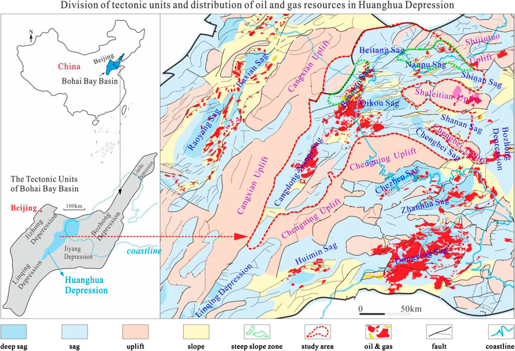
Figure 1. Division of tectonic units and distribution of oil and gas resources in Huanghua Depression.
The Bohai Bay Basin can be further divided into a depression part and an uplift part. The uplifts include Gaoyang uplift, Xinhe uplift, Neihuang uplift, Cangxian Uplift, Chengning Uplift, Shaleitian Uplift and Shijiutuo Uplift. The depression area can be divided into seven major depressions, namely Huanghua Depression, Jizhong Depression, Linqing Depression, Jiyang Depression, Bozhong Depression, Liaodong Bay Depression and Liaohe Depression. The interior of the seven major depressions can be further divided into multiple sags. For example, the Huanghua Depression includes Qikou sag, Banqiao Sag, Nanpu sag, etc. (Figure 1). The Huanghua Depression is located in the middle of the Bohai Bay Basin, with a total area of approximately 1.7 × 10⁴ km2. It is adjacent to the Chengning Uplift and the Cangxian Uplift on the east and west sides respectively. It is distributed in the NE - SW direction as a whole, and the strata have been modified by the strong fault depression in the Cenozoic, forming the current shape of a half-graben fault depression with NW faults and SE overlap. There will be slopes between the uplift and the depression or sag. Among them, steep slope zones often develop at the edge-controlling faults, and the steep slope zones are exactly the areas enriched in oil and gas (Figure 1).
The basement of the Bohai Bay Basin is Archean metamorphic rock. In the Early Paleozoic, it was a shallow sea environment, with thick carbonate rocks intercalated with a small amount of mudstone and evaporites. In the Late Paleozoic, it sank as a whole and was a marine-continental transitional deposit. Coal was formed in the Carboniferous, and continental clastic deposits were received in the Permian. In the Triassic, there were sporadic continental clastic rock deposits in some areas. In the Jurassic and Cretaceous, they were deposited in fault depressions, with strong volcanic activities, the formation of deep and large faults at the edges, and the embryonic form of the basin appeared. The Cenozoic is the main development period of the Bohai Bay Basin, dominated by tensile fault depressions. Cenozoic sedimentary strata are widely developed, such as Kongdian Formation (abbreviated as Ek, 50–56.5 million years ago), Shahejie Formation (abbreviated as Es, 30–50 million years ago), Dongying Formation (abbreviated as Ed, 24.6–30 million years ago), Guantao Formation (abbreviated as Ng, 15.6–24.6 million years ago), Minghuazhen Formation (abbreviated as Nm, 2–15.6 million years ago), etc. (Figure 2), which are important oil and gas reservoirs. Among them, the Shahejie Formation can be further subdivided into the first member of the Shahejie Formation (Es1), the second member of the Shahejie Formation (Es2), the third member of the Shahejie Formation (Es3), and the fourth member of the Shahejie Formation (Es4). The source rocks of Ed and Es3 are the most important source rock strata in the Bohai Bay Basin.
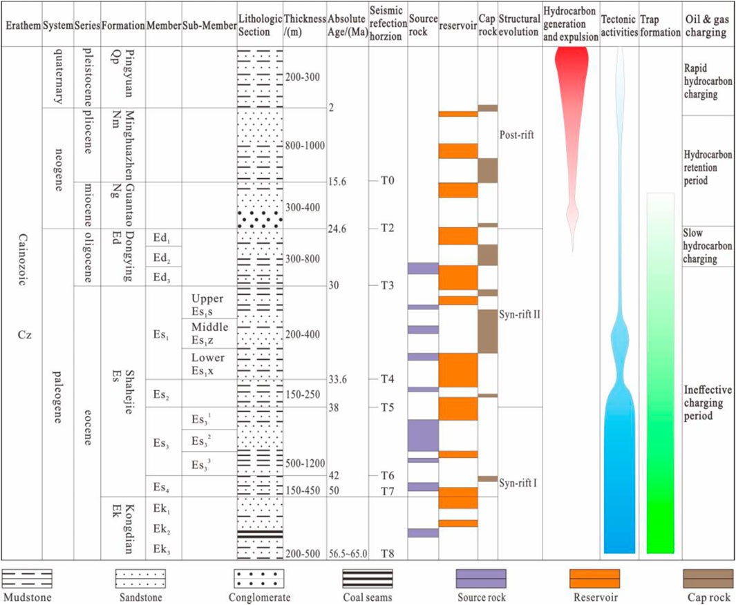
Figure 2. Comprehensive columnar diagram of sedimentary strata in the Bohai Bay Basin.
The data sources of this article mainly include three - dimensional seismic data (with a total coverage area of approximately 30,000 km2), drilling data (data of about 300 wells), and literature materials published by predecessors. Among them, the three - dimensional seismic data of the Huanghua Depression is the main basis, including 7,600 km2 in the Qikou Sag and 5,000 km2 in the Nanpu Sag, and the three - dimensional seismic data in other regions are used as auxiliary references, such as the Liaohe Sag (7,000 km2) and the Jizhong Depression (11,000 km2). The dominant frequency of the three - dimensional seismic data in the Huanghua Depression is ∼35 Hz in the Cenozoic strata, and the vertical resolution is approximately 20–25 m. The three - dimensional seismic data is zero - phase, with a vertical and horizontal spacing of 1 × 1 km. All seismic data are displayed by Geoeast and Landmark software. There are approximately 500 two - dimensional seismic profiles, which are distributed in the northern part of the Cangxian Uplift and the Xiannangzhuang - Baigezhuang area. The main drilling data are the data of 91 wells in the Huanghua Depression, and the Jizhong Depression (190 wells) and the Liaohe Depression (35 wells) are used as auxiliary reference materials. The data of other peripheral depressions of the Huanghua Depression (Jiyang Depression, Bozhong Depression, and Dongpu Sag) mainly come from literature retrieval.
The research methods of this article mainly include literature data collation, seismic data interpretation, palaeogeomorphology characterization, fault activity rate statistics, etc.
Regarding the processing of the three - dimensional seismic data in the Huanghua Depression, it is divided into three aspects: data preprocessing, velocity analysis, and seismic imaging. Firstly, the three - dimensional seismic data is preprocessed, including operations such as trace editing, static correction, and gain recovery. Then, velocity analysis is carried out. The velocity field of the underground medium is determined by using the methods of stack velocity analysis and interval velocity analysis. Through the velocity scanning of the common midpoint gathers (CMP), the velocity information of different horizons is obtained, providing a basis for depth domain conversion and structural form characterization. Finally, seismic imaging is performed. The prestack depth migration or poststack migration technology is used to relocate the seismic reflection waves to their real underground reflection point positions, so as to obtain an accurate underground geological structure image. The prestack depth migration in the Huanghua Depression can better handle complex structures such as underground faults and salt domes, improving the imaging accuracy.
In terms of structural interpretation, first, horizon calibration is carried out. By making synthetic seismic records, selecting an appropriate wavelet and accurately calculating the reflection coefficient, and comparing and adjusting with the seismic traces. Among them, the bottom boundary of Es1z has strong energy and is located above the first peak, and the reflection wave impedance characteristics of the bottom boundary of Es3 are weak and change greatly in the plane. Eventually, the bottom boundaries of multiple horizons such as Nm, Ng, Ed, Es1, Es2 and Es3 are calibrated. The fine interpretation of the interwell strata is based on the results of horizon calibration. According to the strata development situation, the method mainly based on automatic tracking or manual picking is selected to carry out fine interpretation and verification of multiple horizons. In terms of fault interpretation, first, the obvious large faults are interpreted by using seismic profiles, and then combined with auxiliary means such as coherent data volume analysis and horizontal slices to interpret small faults. Among them, the horizontal slice can reflect the dip angle of the strata, the distribution of faults, etc. The coherent volume analysis can identify faults through the similarity of seismic data, but there is ambiguity. The variable density profile is helpful for determining faults through the change of wave groups. The well - to - well comparison ensures the correctness of fault interpretation from the well data. Finally, the fault system is combined following the principle of giving priority to the main faults.
In terms of palaeogeomorphology characterization, based on the high - resolution three - dimensional seismic data, the subsidence backstripping method is applied to backstrip the steep slope zone area, and it is corrected by the compaction correction algorithm. The palaeogeomorphology of the Es3 deposition period in the study area can be restored and visually displayed.
The statistics of fault activity rate are usually based on the measurement and analysis of the changes in strata thickness and fault displacement in different periods. By comparing the vertical displacement difference (fault throw) of the same fault between different horizons with the time interval experienced by the corresponding strata deposition, the activity rate of the fault during this period can be calculated. The core formula is: fault activity rate = (vertical displacement difference of the fault within a certain period)/(time interval experienced by the strata deposition). In the Bohai Bay Basin, the areas where there is no erosion or no obvious erosion amount in the Cenozoic are usually selected for fault activity rate statistics (Liu et al., 2019). Therefore, in this paper, the Cangdong Fault and others are selected for activity rate statistics.
The steep slope zone often refers to the steep part from the bulge to the trough due to the strong activity of the basin-controlling fault and the large drop between the upper and lower walls of the fault. The fault dip is mostly greater than 30°, and the range is roughly from the boundary of the trough to the edge of the bulge (Zhang, 2019; Wang S. et al., 2021; Liu et al., 2023). This paper summarizes the previous research results (Li, 2015; Zhu et al., 2018; Zhang, 2019; Liu et al., 2023), and believes that the steep slope zone has the following characteristics and key definition points: ① In terms of structural geological characteristics: The steep slope zone is located at the edge of the basin, adjacent to the bulge or uplift, connecting the bulge and the sag. Generally, there is a large topographic height difference and a relatively steep topographic slope. The fault activity is strong, which plays an important role in controlling the formation and evolution of the steep slope zone and also affects the migration and accumulation of oil and gas. ② In terms of sedimentary geological characteristics: The steep slope zone is an important channel for sediments to be transported from the bulge to the sag. It is rich in provenance and can quickly accumulate a large amount of coarse clastic materials such as glutenite. Due to the steep terrain slope and strong hydrodynamic conditions, the sedimentary facies change quickly. Sedimentary facies types such as fan deltas and subaqueous fans are often developed. ③ In terms of oil and gas accumulation conditions: The steep slope zone is close to the oil source. The oil and gas generated in the oil-generating sag can quickly migrate to the steep slope zone through channels such as faults, providing favorable conditions for oil and gas accumulation. Coarse clastic sediments provide a good material basis for the reservoir of oil and gas, making the steep slope zone an important place for oil and gas accumulation and having high oil and gas exploration value.
The type of the steep slope zone and the intensity of the boundary fault’s fracturing activity will control the connection mode of the source and reservoir and the hydrocarbon enrichment strata, which are the main controlling factors for the differences of various types of oil and gas reservoirs in the steep slope zone (Zhu et al., 2014; Li, 2015; Chen et al., 2021). The type of the steep slope zone is mainly controlled by the three-dimensional spatial form of the controlling-edge fault. Based on the morphology and occurrence of the main faults in the steep slope zone and the activity history of the main faults, this paper divides the steep slope zones of each sag in the Bohai Bay Basin into three types (Figure 3): shovel-shaped steep slope zone, slope-flat type steep slope zone (named chair-shaped or pedestal-shaped in some areas) and fault-step type steep slope zone (named stepped or horsetail-shaped in some areas) (Zhang, 2019; Deng et al., 2020; Gao, 2021).
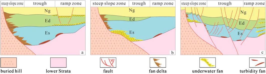
Figure 3. Classification of the steep slope zones in the Huanghua Depression [(A) Shovel-shaped steep slope zone; (B) Slope-flat type steep slope zone; (C) Fault-step type steep slope zone].
The shovel-shaped steep slope zone refers to a steep slope zone controlled by a single main fault, with multiple secondary faults developing in the same or opposite directions. The main fault of the shovel-shaped steep slope zone is shaped like a shovel, directly shoveling into the underlying strata from the uplift, and has the characteristic of being steep on the top and gentle on the bottom (Figure 3A). The steep slope zone in the Nanpu Sag is formed under the control of the Baigezhuang Fault; the steep slope zone in the Banqiao Sag is developed by the Cangdong Fault, etc. The controlling concave faults of this type of shovel-shaped steep slope zone generally have an earlier active period, mainly during the sedimentary period from the Kongdian Formation (Ek) to the Fourth Member of the Shahejie Formation (Es4). With the increase in depth, the dip angle of the main fault gradually decreases, and the strata on the hanging wall of the fault block may tilt towards the fault plane and be accompanied by reverse drag structures. Shovel-shaped normal faults are generally transformed from planar faults. With the continuous regional tensile stress acting on the strata, the fault throw becomes larger and larger, and the strata on the hanging wall of the fault continue to thicken. Under the action of gravity, the fault gradually evolves from a plate shape to a shovel shape. During the development of the fault, the hanging wall of the strata is affected by the gravity of the overlying strata, and the dip angle of the fault gradually decreases with the increase in depth. Many sags in the Bohai Bay Basin have developed shovel-shaped normal faults, and the main faults of the steep slopes in the sags are usually the basin-controlling boundary faults.
The main controlling fault of the slope-flat type steep slope zone is in the shape of a slope-flat, composed of a fault slope and a fault flat. The dip angle of the fault slope is large, while the fault flat has a gentle slope and a large width (Figure 3B). For example, in the northern part of the Nanpu sag, the steep slope zone is developed by the Xi’nanzhuang Fault. The main controlling fault of the steep slope shows a change characteristic of steep - gentle - steep. There are mainly two formation mechanisms of the slope-flat type normal faults; one is the deformation of the faults caused by the difference in the physical properties of the rock layers. The slope-flat type normal faults develop fault slopes in the rock layers with stronger competency and fault flats in the rock layers with weaker competency; the other is the modification of the early faults by the later geological processes. For example, the early-formed faults are transformed into slope-flat type normal faults under the influence of compaction or isostatic gravity. The slope-flat type steep slope zone is mainly formed due to stress changes. In the early stage (before and during the sedimentary period of the Shahejie Formation), the strata were strongly stretched by stress, resulting in normal faults perpendicular to the stress direction. During the period from the Shahejie Formation (Es) to the Dongying Formation (Ed), the strata entered a strong tensile period. At this time, the early faults were modified, and secondary faults developed along the basement strata, thus forming the slope-flat type steep slope.
The fault-step type of steep slope zone refers to a stepped structural zone composed of one or several main faults with similar shovel-shaped or slope-flat shapes that have a genetic relationship and multiple secondary faults. A fault-step type steep slope zone is developed in the northern part of the Banqiao Sag. The fault dip angles are relatively large, mostly greater than 45°. Morphologically, multiple faults develop and penetrate multiple sets of strata, and the Paleogene strata above and below the faults do not contact each other, showing a stepped shape (Figure 3C). In some sags, the fault throw between the fault steps is relatively small, and the strata are not completely offset. The main difference from other types of steep slopes is the intense faulting activity in the late stage (Ed-Nm period). The fault-step type of steep slope zone in the Bohai Bay Basin is mainly formed due to the change of stress and the long-term existence.
If faulting activities continue at the same location and the subsidence rate is slightly greater than or equal to the sedimentation rate, a long-term and thick underwater fan deposit will form on the downthrown side of the fault. This sedimentary model is called continuous steep-bank deposition (Liu et al., 2019). The steep-bank deposition of the Chengnan Fault in the Jiyang Depression of the Bohai Bay Basin is a typical example of continuous steep-bank deposition. The types of steep slope zones can be divided into plate-type, shovel-type and fault-step type. The boundaries of the continuous steep-bank deposition steep slope zone are mostly composed of NE and SN faults with torsional tensile properties. The section morphology is mostly shovel-type or plate-type, and the boundary fault activities are relatively stable during each sequence period (Zhong K. et al., 2024; Zhong Q. et al., 2024), forming the described continuously descending basin boundary (Morley et al., 2004). In terms of section morphology, the plate-type steep slope is steep and straight, the shovel-type steep slope zone is shovel-shaped, and the fault-step type steep slope zone is a combination of the main faults in shovel shape and a series of consequent faults oblique to it, and multiple faults converge in the downdip direction.
Glutenite fan bodies are generally formed during the expansion period of the lake basin. The scale and morphology of glutenite fan bodies are mainly controlled by two factors: the paleogeomorphic form and the water volume (Liu et al., 2019; Liu H. et al., 2022; Liu J. et al., 2022). Sand bodies are generally developed on the steep slopes of the lake basin. According to the formation process of glutenite fan bodies, they are classified into four types according to sedimentary characteristics: alluvial fans, nearshore subaqueous fans, fan deltas, and deep-water turbidite fans (Figure 4).
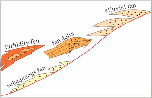
Figure 4. Schematic diagram of the genetic classification of glutenite fan bodies.
The alluvial fan is a kind of rapid accumulation of coarse clastic sedimentary system in front of the mountain (Figure 4), and the main controlling factor is the flood event. Under the dry and hot climate conditions, in the areas with relatively intense crustal uplift and subsidence movement in the Bohai Bay Basin, the weathering and denudation are intense, and the detrital products formed are carried away by the temporary rivers (rain or flood) in the mountainous areas or the mountainous rivers. When the water flow exits the mountain pass, the terrain slope changes sharply and gradually, the water spreads out in all directions, the flow velocity drops sharply, and a large amount of detrital materials accumulate, forming a cone-shaped or fan-shaped coarse clastic sedimentary body, becoming a flood cone or proluvial fan. It has the characteristics of alluvial genesis of mountainous rivers, so it is also called an alluvial fan (Wang L. et al., 2021). The formation and development of alluvial fans in the Bohai Bay Basin are controlled by factors such as natural geography, climatic conditions and crustal uplift and subsidence movements (Lin et al., 2004). The stronger the tectonic movement, the greater the topographic height difference and the drier the climate, the more developed the alluvial fan sedimentary body.
Fan deltas are glutenite bodies deposited at the junction of active fan bodies and stable water bodies with materials provided by alluvial fans under the premise of large topographic height difference at the lake shore, steep basin slopes, close proximity to the source and sufficient source supply (Lin et al., 2004; Jia et al., 2021; Zhang L et al., 2024; Zhang M et al., 2024; Zhang W et al., 2024) (Figure 4). The distribution of fan deltas is limited, and some are underwater. The structural characteristics are the main controlling factors for their formation and development. Their profile morphology is generally wedge-shaped and has obvious progradational reflection structures (Jia et al., 2021; Zhang L et al., 2024; Zhang M et al., 2024; Zhang W et al., 2024), which are medium-amplitude and medium-continuous “S”-shaped or imbricated reflections, converging towards the lake basin. From the mountain front to the lake basin, the thickness of the fan body gradually thins and the grain size of the sediments gradually becomes finer, eventually connecting with the lacustrine facies mudstone (Jia et al., 2021). According to the sedimentary facies characteristics, the fan deltas in the Bohai Bay Basin can be divided into fan delta plain subfacies, fan delta front subfacies and pro-fan delta subfacies.
The fan delta is an alluvial fan that advances from the adjacent highland into a stable water body (sea or lake), and its basic conditions for development are that the terrain of the source area is high, the slope is steep, and there are abundant material source conditions (Lin et al., 2004; Jia et al., 2021). Due to the intense faulting activities, it easily becomes a favorable location for the development of fan deltas. In terms of the evolution stage of the lake basin, fan deltas mostly develop during the rift and convergence periods of the basin, and they develop in both the transgressive system tract and the highstand system tract of Es3. Compared with the gentle slope fan delta system, the fan delta system in the steep slope zone has the following characteristics: The slope angle of the steep slope is large, it is close to the material source, and has high energy. Therefore, the material source is not sorted before entering the water, resulting in the mixed accumulation at the root of the sediment; Because the water body inside the steep slope is relatively deep, after the fan delta of the steep slope enters the lake, it can directly enter the deep lake or semi-deep lake. The high-energy material source continues to move forward under the support of the lake water, and has a strong ability to carry the material source and the ability to cut the bottom. Many facies zones show the characteristics of gravity flow, and the hydrodynamic conditions are complex; The underwater distributary channels of the fan delta in the steep slope zone are due to the relatively intense episodic nature of the material source entering the lake from the steep slope. The water channels often lack inheritance, and the bottom scouring and erosion effects are obvious. Subjected to the dual transformation of water channel scouring and lake water waves, it is not easy to form a complete sequence of estuary bars in front of the water channel, but instead forms a large-area distributed frontal floret-shaped sand sequence.
The nearshore subaqueous fan is the main development type of glutenite bodies in the steep slope zone of the Bohai Bay Basin (Figure 4). It is a glutenite fan with the characteristics of both deep-water gravity flow deposition and tractive current deposition during the lake transgression or high water level system tract period when the rift lake basin expands and the water area expands, and a large amount of coarse detrital materials from the land source are carried by the seasonal mountain floods near the material source and directly enter the lake basin along the steep slope (Liu et al., 2020; Yang et al., 2023; Li X. et al., 2024; Li Z. et al., 2024). It can be divided into three subfacies: fan root, fan middle and fan end. The fan root is composed of thick or massive glutenite and conglomerate sandstone; the fan middle is mainly fine conglomerate and medium sandstone, reflecting the characteristics of rapid accumulation near the material source; the fan end is mainly mudstone with a small amount of sandstone. Due to the accumulation sedimentation mode of the nearshore subaqueous fan, a strong physical interface can be formed. Therefore, it has typical seismic reflection characteristics of the fan body on the seismic section, which is mound-shaped laterally and wedge-shaped longitudinally, and the internal reflection structure is chaotic or wedge-shaped and divergent. If there is a large main supply channel and the sedimentation rate is less than the subsidence rate, then with the continuous expansion of the water body, a complex of multi-stage nearshore subaqueous fans with the combination characteristics of longitudinal superimposition and stepped retreat will be formed; when the sedimentation rate is slightly greater than or equal to the subsidence rate, a group of nearshore subaqueous fans with the characteristics of vertical and lateral superimposition will be formed.
The nearshore subaqueous fan is formed under the condition of water body overcompensation (Liu et al., 2020; Xu et al., 2020; Li et al., 2022), and it is a fan-shaped conglomerate body formed underwater in the shore-shallow lake and semi-deep lake area. With the expansion of the lake water range, the fan body also keeps retreating, and the fan body is always distributed along the edge of the lake basin close to the foothills, which is particularly obvious in the steep slope section. With the generation, development and disappearance of the fan body, the planar facies belts gradually migrate towards the bulge direction. From bottom to top, it shows fan root - fan middle - fan end - shallow lake - deep lake deposition, constituting a vertical sequence that becomes finer and thinner upward. In addition, the periodic changes of tectonic activities, material source supply and the advance and retreat of lake water also affect the sedimentary characteristics and scale of the fan body. This type of sediment is widely developed in rift lake basins, especially during the water transgression and high water level periods of the rift lake basins. Compared with the proluvial fan, the degree of mixing is reduced, but the lithology becomes finer and the color becomes darker, reflecting the characteristics of near material source and rapid underwater accumulation. It is mainly composed of coarse- to medium-grained sandstone with pebbles, with reduced conglomerate and increased mudstone interlayers, mainly composed of light gray, gray and gray-green mudstone.
The planar distribution of the nearshore subaqueous fan is also controlled by the boundary faults of the steep slope (Gruszka and Zieliński, 2021; Li et al., 2022; Liu H. et al., 2022; Liu J. et al., 2022), and there is a good correspondence between the gullies and the fans. In terms of sedimentary structures, common grain-size sequence bedding, parallel bedding, horizontal bedding and deformation structures are often observed, but a single layer generally has the characteristics of normal grain-size sequence, with scour structures and massive bedding at the bottom, and changes to grain-size sequence bedding, parallel bedding, wavy bedding, etc. From the perspective of its grain size distribution characteristics, from the fan root to the fan end, it generally shows a change from coarse to fine. With the weakening of the hydrodynamic force, the facies changes to lacustrine mudstone. On the grain size graph, it shows the characteristics of coarse particle size, wide grain size range and high content of suspended components. In terms of the grain size probability curve, the main curve types include both gravity flow and tractive current. Different facies belts show different characteristics. The overall hydrodynamic environment is mainly underwater gravity flow, supplemented by tractive current.
Mountain floods directly discharged into the lake along the paleo-fault plane, and a large amount of debris was rapidly accumulated at the place where the slope became gentle (Cheng et al., 2023), forming a deep-water turbidite fan (Figure 4). Due to the high flow velocity, the water has the ability to continue to transport and cut downward after entering the lake, so it is easy to form a large fan body. Generally speaking, the fan body has poor sorting and rounding, and low compositional maturity, becoming a liquefied deep-water turbidite fan (Tian et al., 2023), that is, a turbidite fan that has just liquefied and has not yet been sorted and deposited. This type of fan body has poor reservoir performance.
Axial grooves are developed at the foot of the slope on the edge of the basin, and fault grooves are developed in the downthrown side of the fault, parallel to the fault and the lake shoreline. The supply of gravity flow of debris materials comes from multiple directions, including both the long-axis direction and multiple point sources on the short-axis slope. After the deep-water turbidite fan replenishment channel crosses the fault, it will spread along the fault groove and flow to the lowest end of the basin, finally forming axial turbidity current or channel turbidite fan sediments unique to the steep slope zone. The planar morphology of the fan body in this type of basin steep slope zone is controlled by the occurrence of the steep slope fault, and its strike is consistent with the gully and often intersects the shoreline at an oblique angle, showing a rootless distribution in the deeper water in front of or on the flank of the nearshore subaqueous fan. With the deepening of the lake water, the fan body also keeps retreating along the shoreline, and even superimposes on the subaqueous fan body.
The sedimentary characteristics of the glutenite fan bodies in the steep slope zone are mainly closely related to the following three factors: The source supply capacity determines the source and abundance of the sediments; The sand transportation capacity directly affects the transportation efficiency and range of the glutenite; The carrying capacity determines the final scale and stability of the fan bodies (Hubbard et al., 2014; Turner, 2015; Cao et al., 2018).
A stable source supply is prone to form a wedge-shaped fan body with multiple superimposed periods and a large scale, while a conical structure reflects the feature of gradually diminishing material source supply and a small fan body scale. In the Cangdong - Xi’nanzhuang - Baigezhuang steep slope zone of the Bohai Bay Basin, through the detailed delineation of the fan body, the seismic section shows reflection structures such as wedge-shaped, long eggplant-shaped, and conical along the direction of the material source (Figure 5). Among them, the wedge-shaped fan body has a large development scale, with a planar distribution area of 51.56 km2 and a longitudinal extension distance reaching 7.2 km. It indicates a strong source supply capacity during this sedimentary period and a long-term stable source supply, enabling the long-term and stable superimposed deposition of glutenite. Moreover, its strong hydrodynamic conditions allow the sand body to penetrate deeply in the longitudinal direction; The fan body with a long eggplant-shaped structure has a medium-small scale, with a planar distribution area of 8.1 km2 and a longitudinal extension distance reaching 2.5 km. It reflects stable source supply and strong hydrodynamic conditions during the early sedimentary stage, with the sand body penetrating deeply in the longitudinal direction. During the middle and late stages, the source supply capacity rapidly weakens and the hydrodynamic conditions decline; The fan body with a conical structure has a small scale, with a planar distribution area of 3.2 km2 and a longitudinal extension distance reaching 1.3 km. It indicates a strong source supply capacity during the early sedimentary stage, with the sand body penetrating deeply in the longitudinal direction and gradually weakening in the later stage (Figure 6).
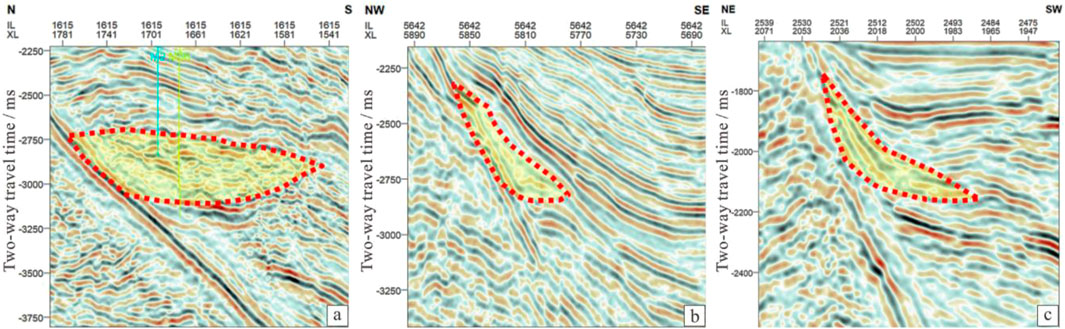
Figure 5. Profile structure of fan bodies in the Cangdong - Xi’nanzhuang - Baigezhuang steep slope zone of the Bohai Bay Basin [(a) Wedge-shaped sedimentary body; (b) Long eggplant-shaped sedimentary body; (c) Conical sedimentary body].
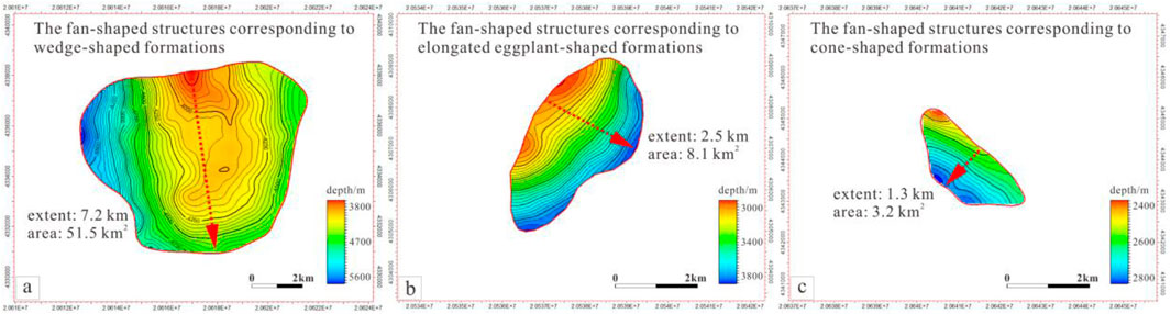
Figure 6. Top surface structure map of fan bodies in the Cangdong - Xi’nanzhuang - Baigezhuang steep slope zone [(a) Wedge-shaped fan body; (b) Long eggplant-shaped fan body; (c) Conical fan body].
The sedimentation of the glutenite fan body in the steep slope zone is mainly related to the source supply capacity, sand transportation capacity and carrying capacity. Among them, the spatial development characteristics of the sand transportation channel in the steep slope zone determine the sand body transportation flux and control the distribution pattern and scale of the sand body. The sand transportation channels of the glutenite bodies in the steep slope zone of the Huanghua Depression are mainly dominated by ancient gullies and fault troughs. There are mainly three types of cross-sectional shapes: V-shaped, U-shaped and W-shaped. The gully shape can reflect its sand transportation capacity and hydrodynamic conditions to a certain extent. The V-shaped groove is generally narrow and deep, which reflects a strong hydrodynamic condition and a strong downcutting and erosion effect. The U-shaped groove is generally relatively wide and shallow, providing a large cross-sectional area and a strong sand transportation capacity. The W-shaped composite groove has a large width and a large cross-sectional flux, and has a strong sand transportation capacity.
In the western steep slope zone of the Shaleitian Uplift in the Huanghua Depression, as indicated by the regional seismic framework profile in the NW-SE direction on the south side (Figure 7), both ancient gully material source channels (high potential area) and fault trough material source channels (relatively low potential area) are developed in the study area. The parameters of width, depth, width-depth ratio and cross-sectional area of the material source transportation channels are quantitatively statistically analyzed to comprehensively characterize their transportation and sedimentation fluxes. Among them, V2, V3 and V4 correspond to single fault troughs. The width of V3 is 2.227 km, the depth is 0.097 km, the maximum width-depth ratio is 22.96, and its cross-sectional area is 0.108 km2, indicating that its sediment transportation flux is the largest, and the transportation capacity of the V2 fault trough material source channel is stronger than that of V4; V5 and V6 correspond to ancient gullies. The width-depth ratio of V5 is 25.96, and the cross-sectional area is 0.041 km2, which is significantly larger than that of V6, indicating that the transportation capacity of the V5 ancient gully material source channel is stronger than that of V6. By comparing the ancient gully material source channels and the fault trough material source channels, it can be seen that the fault troughs are relatively wide and deep, but the width-depth ratio is smaller than that of the ancient gullies. Comprehensive indication suggests that the total spatial transportation volume corresponding to the ancient gully material source channels should be greater than that of the fault trough material source channels. Thus, among the same type of material source channels, when the parameters of the material source area and the sedimentation area are similar, the transportation flux is often closely related to the scale of the channel (width-depth ratio and cross-sectional area), and generally, the larger the width-depth ratio and cross-sectional area, the greater the material source transportation flux.
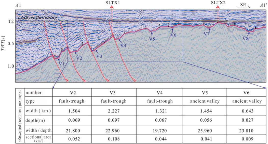
Figure 7. The distribution map of the provenance channels in the steep slope zone between the eastern part of the Huanghua Depression and the western part of the Shaleitian Uplift.
Taking the Laoyemiao Structure in the Xi’nanzhuang steep slope zone as an example, during the sedimentary period of
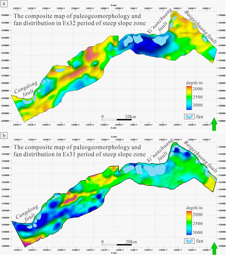
Figure 8. Superimposed map of paleogeomorphology and fan body distribution in the Cangdong - Xi’nanzhuang - Baigezhuang steep slope zone [(a) The composite map of paleogeomorphology and fan distribution in Es32 period of steep slope zone; (b) The composite map of paleogeomorphology and fan distribution in Es31 period of steep slope zone].
The fan glutenite bodies in the steep slope zone of the Huanghua Depression develop conventional oil and gas reservoirs and a small amount of unconventional oil and gas reservoirs. The overall situation is dominated by conventional oil and gas reservoirs, including structural oil and gas reservoirs, lithologic oil and gas reservoirs, and a small number of stratigraphic oil and gas reservoirs (Figure 9). Structural oil and gas reservoirs are mainly formed on the cliff-type faulted surface and tuned by secondary faults, and they often develop in the shallow layer. Lithologic oil and gas reservoirs mainly include two types. One is the independent lenticular lithologic reservoir formed by slumped turbidite fans, and the other is the lithologic reservoir formed by physical sealing at the fan root, which is mainly developed near the faulted surface. If the fan middle and fan end of these fan bodies are cut by faults, fault-lithologic oil reservoirs are formed. Stratigraphic oil reservoirs are commonly developed in the middle and shallow fan bodies, mainly as stratigraphic overlap oil and gas reservoirs. Taking the steep slope zone of Bonan Subsag in the Bohai Bay Basin as an example, unconventional oil and gas reservoirs mainly develop continuous oil and gas reservoirs (Ma et al., 2015), and their main characteristics are: ① Lack of obvious trap boundaries; ② Reservoirs are often low or ultra-low porosity and permeability reservoirs; ③ Lack of obvious oil-gas-water boundaries; ④ Large-area distribution; ⑤ Generally contain oil and gas; ⑥ Have abnormal pressures (overpressure or underpressure); ⑦ Within the source or close to the source rock; ⑧ Generally have a low content of movable water.
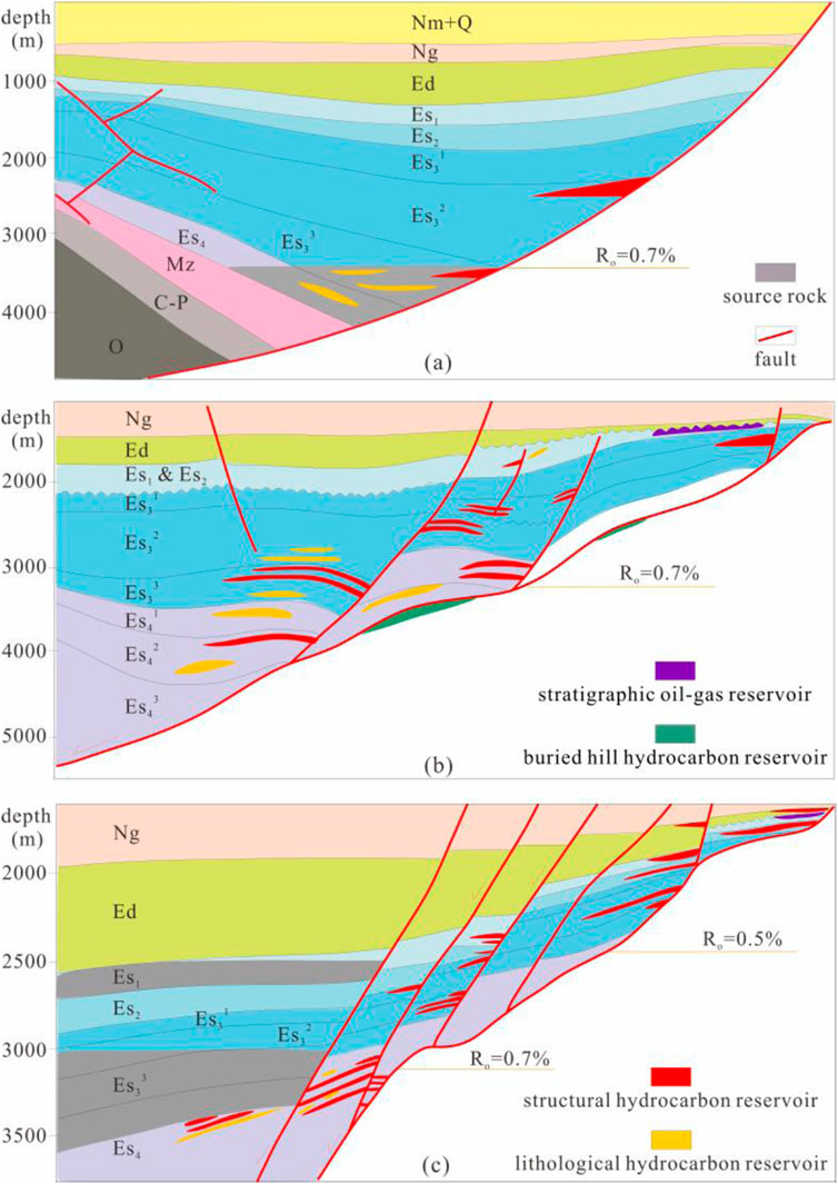
Figure 9. Oil and gas distribution patterns in steep slope zones [(a) Oil and gas distribution pattern of shovel-shaped steep slope zone; (b) Oil and gas distribution pattern of slope-flat type steep slope zone; (c) Oil and gas distribution pattern of fault-step type steep slope zone].
The types of oil and gas reservoirs in the shovel-shaped steep slope zone are mainly structural and lithologic reservoirs, and the two account for more than 90% of the total oil and gas in the steep slope. On the plane, from the center of the depression to the edge of the steep slope, the shovel-shaped steep slope zone develops lithologic and structural oil and gas reservoirs successively. On the section, lithologic oil and gas reservoirs are mainly developed near the depression, and structural oil and gas reservoirs are developed near the main faults of the steep slope (Figure 9A).
According to the previous research results, the lower sub-member of the third member of Shahejie Formation (
The types of oil and gas reservoirs in the slope-flat type steep slope zone are fully developed, including structural, lithologic and stratigraphic reservoirs, mainly structural and lithologic reservoirs. On the plane, from the center of the depression to the edge of the steep slope, lithologic, structural and stratigraphic oil and gas reservoirs are developed successively. On the section, lithologic oil and gas reservoirs are mainly developed near the depression, structural oil and gas reservoirs are developed near the main and secondary faults of the steep slope, stratigraphic oil and gas reservoirs are developed near the bulge, and a large number of buried hill oil and gas reservoirs are developed at the slope-flat of some depressions (Figure 9B). Among them, the oil and gas in the Baxian Sag are mainly enriched near the depression of the steep slope and are mainly composed of structural and lithologic oil and gas reservoirs (Zhang et al., 2023). The oil and gas in the Dongying Sag are widely distributed and have complete types. From the depression to the bulge, lithologic, structural and stratigraphic oil and gas reservoirs are developed successively. Among them, structural and lithologic oil and gas reservoirs are accumulated in the area near the depression of the steep slope, and stratigraphic oil and gas reservoirs are accumulated in the outer zone of the steep slope. The Damintun Sag develops structural and lithologic oil and gas reservoirs. In the slope-flat type steep slope zone, oil and gas are distributed from Es4 to Guantao Formation (Ng), and the main oil-bearing layers of oil and gas are generally located from Ed3 to Es2, belonging to medium-deep and medium-shallow reservoirs. For example, in the Baxian Sag, the oil and gas are mainly enriched in the third member of the Dongying Formation (Ed3) and the first member of the Shahejie Formation (Es1), and the second member of the Shahejie Formation (Es2) is the main oil-bearing layer in the Dongying Sag. The enrichment series of the slope-flat type steep slope zone are mainly the Paleogene strata above the source rock strata, and a small amount of oil and gas is developed in the Neogene strata.
The oil and gas distribution in the fault-step type steep slope zone is relatively concentrated, and it is generally enriched near the bulge of the steep slope (Zhang, 2019; Sun et al., 2020; Chen et al., 2021). The types of oil and gas reservoirs are relatively simple, with more than 90% being structural oil and gas reservoirs, and only a small amount of lithologic oil and gas reservoirs are developed near the depression. On the section, oil and gas are mainly enriched at all levels of faults, showing a stepped characteristic, mainly structural oil and gas reservoirs (Figure 9C). The main oil-bearing layer of oil and gas in the fault-step type steep slope zone is located in the Neogene, and the oil and gas are enriched in Ed1 and above, belonging to shallow reservoirs. There are also differences in the oil and gas distribution in each sag. Among them, the oil and gas in the steep slope zone of the Zhanhua Sag are mainly enriched near the Chengnan bulge and the Yihezhuang bulge, and the oil and gas are distributed near all levels of faults. The oil and gas in the Nanpu Sag are mainly distributed near the Xi’nanzhuang bulge and the Baigezhuang bulge, and the oil and gas are enriched near the main fault of the steep slope zone. The oil and gas in the Bozhong Sag are mainly distributed near the bulge, and there is basically no oil in the near-depression zone. A large number of structural oil and gas reservoirs are developed in the fault-step type steep slope zone, and the reserves of other types are small or not developed. The oil and gas are enriched near the bulge at the edge of the steep slope, belonging to far-source reservoirs.
Through the investigation and summary of the oil and gas reservoirs of glutenite bodies in the Bohai Bay Basin, the types of steep slope zones and the intensity of fault activities of boundary faults control the docking mode of source and reservoir and the enrichment series of oil and gas, which are the main control factors for the differences of various types of oil and gas reservoirs in steep slope zones.
The source rocks of the depressions developed in the shovel-shaped steep slope zone are relatively deep, generally located from Kongdian Formation (Ek) to the third member of Shahejie Formation (Es3). The contact thickness between the shovel-shaped faults and effective source rocks is relatively small, and the cumulative thickness of source rocks in each layer is between 300 and 600 m. The hydrocarbon-generating layer system in Cangdong Sag is located in the second member of Kongdian Formation (Ek2). The main source rocks such as Dongpu, Langgu, eastern and western parts are all Es3 source rocks. Some depressions generate hydrocarbons in multiple layers. For example, there are also a small amount of source rocks in the upper sub-member of the fourth member of Shahejie Formation (Es4) in Langgu Sag, but the overall thickness is still less than 600 m.
The main faults of the shovel-shaped steep slope are generally single faults, source rocks are deposited in the center of the hydrocarbon-generating depression. From the depression to the steep slope, the strata gradually become shallower and the lithology gradually becomes coarser. A large amount of sand bodies are generally deposited near the main faults, resulting in more direct contact between the faults of the shovel-shaped steep slope zone and the sand bodies adjacent to the source rocks. A deep adjacent-source reservoir-forming structure is formed (Figures 10A, B). In the steep slope zone represented by Banqiao Sag, the dip angle of the main fault is relatively small, the depth of the source rock is relatively large, and some source rocks are in direct contact with the faults. Overall, the shovel-shaped steep slope zone shows the relationship characteristics of thin-layer source rocks adjacent to sand bodies and less contact with faults.
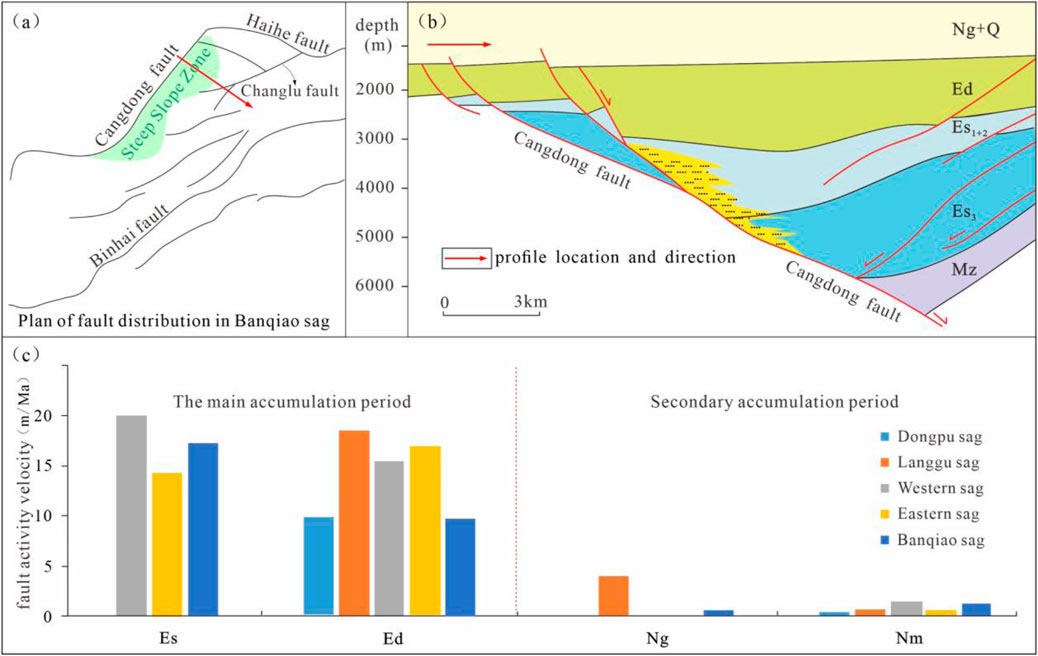
Figure 10. (a) Plan of fault distribution in Banqiao sag; (b) Contact mode of source and reservoir in shovel-shaped steep slope zone; (c) Average activity rate of main faults during reservoir formation period in shovel-shaped steep slope zone.
The oil and gas in the shovel-shaped steep slope zone are mainly accumulated during the Dongying period, featuring early reservoir formation (Figure 10C). Some depressions have late reservoir-forming oil and gas (after Ng and Ng periods), such as Banqiao Sag, Langgu Sag, Eastern Sag and Cangdong Sag (Li, 2015; Zhao et al., 2018a; Zhao et al., 2018b; Zhang, 2019; Gao, 2021). The main faults during the reservoir-forming period of the shovel-shaped steep slope have similar characteristics: during early reservoir formation, the fault activities are relatively strong, with an average activity rate ranging from 10 to 20 m/Ma; during late reservoir formation, the fault activity rate is relatively low, less than 5 m/Ma, such as in Banqiao, Langgu, Eastern, Western and Cangdong Sags. The faults in some depressions have stopped activities, such as in Dongpu Sag. During the main reservoir-forming period of the shovel-shaped steep slope zone, the ability of faults to transport oil and gas is weak, making it difficult to transport oil and gas to shallow strata.
The depressions adjacent to the slope-flat type steep slope zone develop source rocks of Es4, Es3, and Es1. The contact thickness between the main faults of the steep slope zone and effective source rocks is relatively large, with a cumulative thickness ranging from 800 to 1,000 m. Among them, the contact thickness of Es3 and Es4 source rocks with faults is the largest. On the section, the first-level faults of the steep slope zone and the overlying sand bodies are in contact with the source rocks, and the second-level faults are in direct contact with the source rocks. This is because the slope-flat type steep slope zone generally extends far, and a large amount of sand bodies are often deposited at the slope-flat. Shallow source rocks have more contact with sand bodies, while at the bottom of the first-level faults, sand bodies develop less. Therefore, source rocks are in direct contact with deep faults, forming a multi-layer adjacent-source reservoir-forming structure (Figures 11A, B). In addition, secondary faults are often developed at the slope-flat of the slope-flat type steep slope zone. The secondary faults are in direct contact with the source rocks, providing migration channels for the transportation of oil and gas to shallow layers. The slope-flat type steep slope zone generally shows the composite relationship characteristics that source rocks are in contact with both primary and secondary faults.
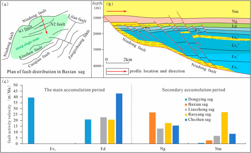
Figure 11. (a) Plan of fault distribution in Baxian sag; (b) Contact mode of source and reservoir in slope-flat type steep slope zone; (c) Average activity rate of main faults during reservoir formation period in slope-flat type steep slope zone.
The main reservoir-forming period of oil and gas in the slope-flat type steep slope zone has two phases. Most of the sags have two phases of reservoir formation. Among them, the Baxian Sag does not have early reservoir formation. During the early reservoir formation, the faults in the slope-flat type steep slope zone are highly active, with an activity rate ranging from 20 to 40 m/Ma (Figure 11C), which plays a vertical conduction role for oil and gas, enabling the early-generated oil and gas to migrate to shallow strata, such as the Liaozhong Sag. During the late reservoir formation, the fault activities are relatively weak, with the maximum activity rate ranging from 10 to 25 m/Ma, which can still have a certain vertical conduction effect on oil and gas, causing some oil and gas to migrate along the main faults and form reservoirs in the middle zone of the steep slope. The faults in the steep slope of some sags show reactivation characteristics, with a relatively large activity rate, such as the Raoyang Sag.
The strata in the fault-step type steep slope zone have a large burial depth, causing the source rocks of the Dongying Formation (Ed) to also enter the hydrocarbon generation threshold, so multiple sets of source rock strata are often developed. The contact thickness between faults and effective source rocks is large, and the cumulative thickness of source rocks in each layer exceeds 1,000 m. Due to the long-term influence of the tensile stress field in the fault-step type steep slope zone, a large number of secondary faults have developed, and sand bodies are mainly distributed in the shallow strata and above the secondary faults. Therefore, faults in the steep slope zone are generally in direct contact with deep source rocks, forming a multi-layer far-source reservoir-forming structure (Figures 12A, B). The first-level faults connect deep source rocks, and sand bodies generally serve as migration channels for lateral transportation of oil and gas, and oil and gas are transported to shallow faults through the spatial configuration of faults and sand bodies.
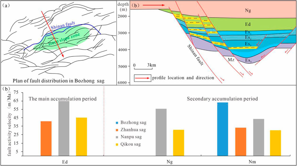
Figure 12. (a) Plan of fault distribution in Bozhong sag; (b) Diagram of source-reservoir contact mode in fault-step type steep slope zone; (c) Diagram of average activity rate of main faults during reservoir formation period in fault-step type steep slope zone.
The main reservoir-forming period of each sag in the fault-step type steep slope zone is after the Ed period, and the late reservoir-forming period is dominant (Figure 12C). Some sags have early reservoir-forming periods, such as the Bozhong Sag (Xu et al., 2024), and the fault activity is strong during the reservoir-forming period. During the early reservoir-forming period, the maximum fault activity rate is between 35 and 70 m/Ma. During the late reservoir-forming period, the fault activity is still very strong, with a maximum activity rate of between 30 and 65 m/Ma, which plays a vertical conduction role for oil and gas. Overall, during the reservoir-forming period of each sag in the fault-step type steep slope zone, the fault activity is strong and lasts for a long time. These faults and the hydrocarbon generation and expulsion periods have formed a good match, providing the driving force for the vertical migration and accumulation of oil and gas, and controlling the vertical distribution of oil and gas. This is also one of the influencing factors for the shallow enrichment of oil and gas in the fault-step type steep slope zone. For example, in the Shinan fault step zone of the Bozhong Sag, the oil and gas are basically enriched in the strata near the bulge, and there are few oil and gas shows in the inner and middle zones of the steep slope.
For the shovel-type steep slope zone, in terms of hydrocarbon migration channels, the faults in the shovel-type steep slope zone are generally steep in the upper part and gentle in the lower part, and the fault plane is often arc-shaped. This shape enables the fault to provide a good migration channel for hydrocarbons during its activity. Hydrocarbons can migrate from the deep source rocks to the shallow reservoirs along the fault plane, promoting the primary and secondary migrations of hydrocarbons. In terms of trap conditions, when the boundary fault in the shovel-type steep slope zone is active, the strata in the hanging wall will slide and rotate, easily forming structural traps such as rollover anticlines. These traps provide favorable places for hydrocarbon accumulation, and hydrocarbons will accumulate in the traps after migrating into them. In terms of the influence on reservoir physical properties, the rocks near the faults in the shovel-type steep slope zone will generate fractures and fracture zones due to the stress, thus improving the physical properties of the reservoir, increasing the porosity and permeability of the reservoir, and making it easier for hydrocarbons to be stored and flow in it.
For the slope-flat type steep slope zone, in terms of hydrocarbon migration channels, the slope-flat type fault is composed of multiple fault flats and fault slopes alternating, and this structure forms a stepped migration channel. Hydrocarbons can migrate upward step by step along the channels composed of fault flats and fault slopes. During the migration process, hydrocarbons will accumulate at different fault flats, forming multiple hydrocarbon reservoirs. In terms of sealing and accumulation effects, the rocks in the fault flat part are relatively dense and have good sealing properties, which can prevent the further migration of hydrocarbons and make hydrocarbons accumulate in the reservoirs above the fault flat to form hydrocarbon reservoirs. At the same time, the fractures and fracture zones in the fault slope part also provide channels for the lateral migration of hydrocarbons, enabling hydrocarbons to accumulate in the reservoirs on both sides of the fault slope. In terms of the control of hydrocarbon distribution, the distribution and shape of the slope-flat type master boundary fault determine the distribution range and scale of hydrocarbon reservoirs. Hydrocarbons usually accumulate in the reservoirs in the upthrown and downthrown blocks of the fault, and form hydrocarbon-rich areas at the intersections of fault flats and fault slopes.
For the fault-step type steep slope zone, there are multi-stage migrations and accumulations in the fault-step type steep slope zone. The fault step zone is a stepped structural zone formed by the cutting of multiple main faults. This structure provides multi-stage migration channels for hydrocarbons. Hydrocarbons can migrate upward successively along different levels of faults and accumulate at the sealing positions of each level of faults to form hydrocarbon reservoirs, thus forming a multi-layer hydrocarbon accumulation pattern. For the complex fault type traps, the faults in the fault step zone intersect with each other, forming various complex trap types, such as fault block traps, fault - lithology traps, etc. These traps provide a variety of places for hydrocarbon accumulation, increasing the complexity and diversity of hydrocarbon reservoirs, and enabling hydrocarbons to accumulate in different types of traps. In terms of enhancing the degree of hydrocarbon enrichment in the fault-step type steep slope zone, due to the multi-stage migration and complex trap effects of the fault-step type faults, hydrocarbons can be continuously enriched and adjusted during the migration process, and finally form a hydrocarbon-rich zone within the fault step zone. In this rich zone, the number of hydrocarbon reservoirs is large, the reserves are large, and the degree of hydrocarbon enrichment is high.
In terms of migration channels, the hydrocarbons in the shovel-type steep slope zone mainly migrate along the arc-shaped fault plane, and the migration direction is relatively single, but the migration distance may be relatively long. The hydrocarbons in the slope-flat type steep slope zone migrate through the stepped channels composed of fault flats and fault slopes, and the migration direction has a certain stage and directionality, and hydrocarbons may accumulate at each fault flat. The hydrocarbons in the fault-step type steep slope zone migrate in multiple stages along multiple parallel or approximately parallel faults, and the migration path is relatively complex, and hydrocarbons can communicate and adjust between different levels of faults.
In terms of trap types and distributions, the shovel-type steep slope zone mainly forms structural traps such as rollover anticlines, and the traps are usually distributed in the hanging wall of the fault and are relatively concentrated. The trap types in the slope-flat type steep slope zone are mainly structural - lithology traps above the fault flat and fault - lithology traps on both sides of the fault slope, and the traps are distributed at and near the intersections of fault flats and fault slopes, showing a banded distribution. The trap types in the fault-step type steep slope zone are rich and diverse, including fault block traps, fault - lithology traps, etc., and the traps are distributed in various parts of the fault step zone, forming multiple hydrocarbon accumulation areas, and the distribution is relatively scattered but has a certain regularity.
In terms of the influence on the scale and enrichment degree of hydrocarbon reservoirs, the scale of hydrocarbon reservoirs in the shovel-type steep slope zone is relatively large, the reserves of a single hydrocarbon reservoir are relatively high, but the number of hydrocarbon reservoirs is relatively small. Hydrocarbons accumulate in traps such as rollover anticlines, and the enrichment degree is relatively high. The scale of hydrocarbon reservoirs in the slope-flat type steep slope zone is relatively small, but due to its stepped structure, the number of hydrocarbon reservoirs is relatively large, and the overall reserves are also considerable. Hydrocarbons are enriched at the intersections of fault flats and fault slopes, and the enrichment degree is relatively high. The number of hydrocarbon reservoirs in the fault-step type steep slope zone is large, and the scale varies. The overall reserves are large. Hydrocarbons are enriched in different parts of the fault step zone, forming a hydrocarbon-rich zone, and the enrichment degree is relatively high.
In recent years, the Bohai Bay Basin has based on the key areas and zones for increasing reserves in oil-rich sags, conducted overall research, overall evaluation, and overall deployment, and achieved remarkable results in oil and gas exploration. As people’s understanding of the importance of finding subtle oil reservoirs has deepened day by day, lithologic-stratigraphic oil and gas reservoirs in slope areas have become a realistic field for large-scale increase of oil reserves. There have been new breakthroughs in oil exploration in the steep slope zone. In recent years, significant exploration discoveries have been made in the northern steep slope zone of the Zhanhua Sag, the northern steep slope zone of the Nanpu Sag, the Lengdong steep slope zone in the western sag of Liaohe, the west steep slope of Damintun in Liaohe, and the west wing of the central uplift, showing good exploration prospects (Zhang, 2019; Deng et al., 2020; Gao, 2021; Li et al., 2021a; Li et al., 2021b; Ye, 2022). As a typical representative of lithologic oil reservoirs, glutenite bodies in the steep slope zone are an important exploration and reserve-increasing type in the Bohai Bay Basin.
The Huanghua Depression is located in the center of the Bohai Bay Basin and belongs to the Cenozoic rift basin. Within the depression, eight positive structural belts such as the Kongdian Buried Hill Structural Belt, the Nandagang Buried Hill Structural Belt, the Beidagang Buried Hill Structural Belt, the Banqiao Fault Structural Belt, the Shenqingzhuang Fault Structural Belt, and the Xiaoji Fault Structural Belt, and five negative sub-level structural units such as the Qikou Sag, the Banqiao Sag, the Cangdong Sag, the Nanpu Sag, and the Beitang Sag have developed, forming a structural pattern of “alternating concave and convex”, among which the Cangdong - Xi’nanzhuang - Baigezhuang steep slope zone is the key research area of the Huanghua Depression.
The deep source rocks in the steep slope zone of the Banqiao Sag and the Nanpu Sag are mainly the dark mudstones of Es3, which are widely distributed on the plane, with a central thickness of 600–1,000 m. They have a high organic matter abundance, the kerogen type is II2 - III, and the evolution degree of the source rocks is high. The vitrinite reflectance (Ro) of Es3 is 1.2%–2.5%, and the gas generation intensity is greater than 20 × 108 m3/km2, which are the main source rocks of the Banqiao Sag and the Nanpu Sag. The large-scale fans in the steep slope zone have formed abundant glutenite reservoirs, providing effective reservoir space for glutenite oil reservoirs. In the fan delta development zone of the Xi’nanzhuang steep slope zone, it can be divided into three types of reservoir development areas. Type I reservoirs are mainly coarse-grained sediments of the near-source underwater distributary channels at the front of the fan delta, mainly composed of glutenite or unequal-grained sandstone. Type II reservoirs are mainly distributed in the underwater distributary channels or estuary bar sediments in the middle section of the fan delta, with relatively fine grain size, mainly fine sandstone. Type III are mostly fine - siltstone deposited at the distal end of the front of the fan delta or the prodelta. In the nearshore subaqueous fan development zone of the Cangdong steep slope zone, three types of reservoir development areas are divided. Type I reservoirs are mainly coarse-grained sediments deposited in the middle channel of the fan, mainly composed of glutenite. Type II reservoirs are mainly distributed at the fan end, mainly composed of unequal-grained sandstone or fine sandstone, with relatively fine grain size. Type III are mostly distributed at the fan root, mainly composed of dense glutenite from near-source deposition, with relatively coarse grain size.
With the advancement of exploration technology, a considerable number of lithologic oil and gas reservoirs are produced in the lower parts of hydrocarbon-generating sags or even negative structural centers. Therefore, lithologic traps within the sags have become the focus of oil and gas exploration. The characteristics of multiple material sources, multiple subsidence centers, and alternating uplifts and depressions in the Banqiao Sag and the Nanpu Sag have created multiple types of sedimentary systems. The nearshore subaqueous fans and fan deltas within the sag are separated and surrounded in three-dimensional space, forming a good source-reservoir-cap assemblage. After the source rocks around them mature, oil and gas can be directly transported from the source rock layer to the reservoir layer under the action of capillary force and accumulate, forming self-generated and self-stored oil and gas reservoirs.
The supply capacity, groove transport flux, and the structure, shape and area of the catchment area of the Cangdong - Xi’nanzhuang - Baigezhuang steep slope zone have an important control effect on some parts of the fan conglomerate fan body. Based on the previous understanding of the discovered fan conglomerate bodies in the Bohai Bay Basin, the Cangdong - Xi’nanzhuang - Baigezhuang steep slope zone mainly develops fan delta systems and nearshore subaqueous fan systems. The nearshore subaqueous fan system is widely distributed in the Cangdong - Xi’nanzhuang - Baigezhuang steep slope zone, and is distributed in a continuous skirt-shaped zone in the Cangdong steep slope zone of the Banqiao Sag, and is also continuously distributed in the eastern section of the Xi’nanzhuang steep slope zone and the Baigezhuang steep slope zone of the Nanpu Sag (Figure 13).
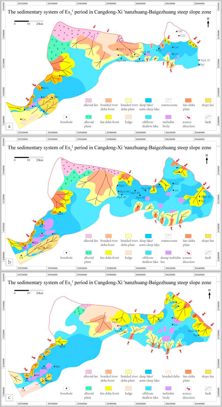
Figure 13. Sedimentary System of Es3 in Cangdong - Xi’nanzhuang - Baigezhuang Steep Slope Zone [(a) Sedimentary System of
During the
The catchment area is the place where sediments accumulate. Therefore, the structural form of the catchment area affects the dominant accumulation direction of the sand body. The area and depth of the catchment area also determine the volume of sediments it can carry. For example, the Xi’nanzhuang fault was strongly active during the
During the
Through the overall study of the fan conglomerate fan bodies in the Cangdong - Xi’nanzhuang - Baigezhuang steep slope zone (Figure 13), combined with the quantitative anatomy of the glutenite fan bodies in the steep slope zones of other sags in the Bohai Bay Basin and the regional reservoir-forming rules (Li, 2015; Chen et al., 2021; Gao, 2021; Yang et al., 2022; Chen H. et al., 2024; Chen Y. et al., 2024), it can be known that the glutenite bodies in the Cangdong - Xi’nanzhuang steep slope zone are adjacent to the hydrocarbon-generating depression, and the glutenite reservoirs are buried in the high-quality Es3 source rocks, forming a hydrocarbon supply mode of direct contact between the source and reservoir; after the source rocks mature, they can directly enter the glutenite reservoirs; oil and gas are laterally conducted within the glutenite bodies, and at the same time, they are transported through secondary faults to control the vertical distribution and adjustment of oil and gas; finally, they accumulate and form reservoirs in effective structural traps or lithologic traps. The source, channel and catchment of the steep slope zone have a very good coupling relationship and have excellent exploration potential.
Overall, the glutenite bodies in the Cangdong steep slope zone are adjacent to the hydrocarbon-generating depression, belonging to the deep adjacent-source reservoir-forming structure, with a short oil and gas migration distance and superior reservoir-forming conditions, and it is easy to form lithologic oil and gas reservoirs; the Xi’nanzhuang steep slope zone is a multi-layer adjacent-source reservoir-forming structure, with a short oil and gas migration distance. The secondary faults adjust the oil and gas migration to the upper reservoirs. The reservoir-forming conditions are superior, and it is easy to form lithologic and structural oil and gas reservoirs; the Baigezhuang steep slope zone is relatively far from the hydrocarbon-generating depression. It is a multi-layer far-source reservoir-forming result. Compared with the Cangdong and Xi’nanzhuang steep slope zones, the oil and gas migration distance is long, and the reservoir-forming conditions are poor, it is easy to form structural oil and gas reservoirs.
1. According to the spatial morphology and activity history of boundary faults, the steep slope zone can be divided into spade-shaped steep slope zone, slope-flat steep slope zone and stepped steep slope zone. A large amount of coarse clastic materials rapidly accumulated in the steep slope zone will form glutenite fan bodies (alluvial fans, nearshore subaqueous fans, fan deltas, deepwater turbidite fans), which have the characteristics of high porosity and high permeability and are conducive to oil and gas accumulation.
2. The control effect of the steep slope zone on the glutenite fan body is reflected in three aspects: “source-channel-sink”. The area of the source region determines the source supply capacity, and the material source supply affects the vertical morphology and scale of the fan body. The development characteristics of the sand transportation channel determine the transportation flux and control the distribution pattern and scale of the sand body. The structure and morphology of the sink area control the distribution direction of the fan body and the dispersed form of the sand body.
3. The glutenite bodies in the steep slope zone are mainly composed of structural oil and gas reservoirs and lithologic oil and gas reservoirs. The type of steep slope zone and the activity intensity of boundary faults are the main controlling factors for the differences of various types of oil and gas reservoirs in the steep slope zone. Among them, the boundary fault controls the docking relationship between oil source and reservoir and the oil and gas enrichment horizon.
4. The Cangdong - Xi’nanzhuang - Baigezhuang steep slope zone in the Bohai Bay Basin mainly develops fan delta systems and nearshore subaqueous fan systems. The glutenite body in the Cangdong steep slope zone is close to the oil-generating sag and belongs to the deep-seated reservoir-forming structure close to the oil source, and is easy to form lithologic oil and gas reservoirs. The Xi’nanzhuang steep slope zone is a multi-layer reservoir-forming structure close to the oil source with a short oil and gas migration distance. Secondary faults adjust the migration of oil and gas to the upper reservoirs and are easy to form lithologic oil and gas reservoirs and structural oil and gas reservoirs. The Baigezhuang steep slope zone is relatively far from the oil-generating sag and is a multi-layer reservoir-forming structure far from the oil source, and is easy to form structural oil and gas reservoirs.
The original contributions presented in the study are included in the article/supplementary material, further inquiries can be directed to the corresponding author.
HL: Conceptualization, Data curation, Formal Analysis, Funding acquisition, Investigation, Methodology, Resources, Validation, Writing–original draft, Writing–review and editing. YC: Data curation, Formal Analysis, Investigation, Software, Writing–original draft, Writing–review and editing. JW: Conceptualization, Data curation, Funding acquisition, Investigation, Methodology, Project administration, Resources, Supervision, Visualization, Writing–original draft. DS: Conceptualization, Data curation, Formal Analysis, Investigation, Methodology, Project administration, Writing–original draft. ZT: Data curation, Formal Analysis, Investigation, Methodology, Resources, Writing–original draft. CZ: Formal Analysis, Funding acquisition, Methodology, Writing–original draft. FW: Formal Analysis, Funding acquisition, Methodology, Resources, Writing–original draft. ZJ: Methodology, Resources, Software, Writing–original draft.
The author(s) declare that financial support was received for the research, authorship, and/or publication of this article. This research was funded by the National Key Research and Development Program of China. Grant number: 2023YFF0804303.
The authors declare that the research was conducted in the absence of any commercial or financial relationships that could be construed as a potential conflict of interest.
The reviewer LQ declared a shared affiliation with the authors YC and ZJ to the handling editor at the time of review.
All claims expressed in this article are solely those of the authors and do not necessarily represent those of their affiliated organizations, or those of the publisher, the editors and the reviewers. Any product that may be evaluated in this article, or claim that may be made by its manufacturer, is not guaranteed or endorsed by the publisher.
Cao, Y., Wang, Y., Gluyas, J. G., Liu, H., Liu, H., and Song, M. (2018). Depositional model for lacustrine nearshore subaqueous fans in a rift Basin: the eocene Shahejie Formation, Dongying Sag, Bohai Bay Basin, China. Sedimentology 65, 2117–2148. doi:10.1111/sed.12459
Chen, X., Wang, F., Li, H., Yin, J., Xie, M., and Cao, Y. (2021). Differential oil accumulation and its controlling factors for CFD6-4 oilfield at the steep slope belt on the southern margin of Shijiutuo Uplift in Bohai Sea. Mar. Pet. Geol. 133, 105266. doi:10.1016/j.marpetgeo.2021.105266
Chen, H., Xu, S., Cai, C., Shang, W., Mao, J., Xu, Z., et al. (2024a). Fault control on sedimentation in the southern gentle slope of the Dongying Sag, Bohai Bay Basin. Mar. Pet. Geol. 166, 106904. doi:10.1016/j.marpetgeo.2024.106904
Chen, Y., Liu, H., Jiang, Z., Sun, J., Zhao, C., Jiang, W., et al. (2024b). Research on fault-controlled hydrocarbon accumulation in rifted lacustrine basins based on structural geological modeling: a case study of the Banqiao area in Bohai Bay Basin, China. Front. Earth Sci. 11. doi:10.3389/feart.2023.1273223
Cheng, J., He, X., Duan, D., and Li, J. (2023). Turbidite fan deposits in gentle slope zones of continental faulted basins: a case study from the Chezhen depression, Bohai Bay Basin. Processes 11, 2001. doi:10.3390/pr11072001
Chu, R., Yan, D., Qiu, L., Wang, H., and Wang, Q. (2023). Quantitative constraints on hydrocarbon vertical leakage: insights from underfilled fault-bound traps in the Bohai Bay Basin, China. Mar. Pet. Geol. 149, 106078. doi:10.1016/j.marpetgeo.2022.106078
Chu, R., Yan, D., Qiu, L., Chang, D., Wang, Q., Song, X. Q., et al. (2024). Strain partitioning dominated growth of strike-slip fault: insight from the Tan-Lu fault in eastern China. J. Struct. Geol. 182, 105126. doi:10.1016/j.jsg.2024.105126
Deibert, J. E., and Camilleri, P. A. (2006). Sedimentologic and tectonic origin of an incised-valley-fill sequence along an extensional marginal-lacustrine system in the Basin and Range province, United States: implications for predictive models of the location of incised valleys. AAPG Bull. 90, 209–235. doi:10.1306/09140505028
Deng, J., Xia, S., Liu, J., Wu, P., Du, X., Chang, Y., et al. (2020). Sequence architecture and depositional evolution of Dongying Formation in steep slope zone of northern Liaodong Bay and its responses to tectonism. Geol. J. 55, 5251–5274. doi:10.1002/gj.3732
Dooley, T., McClay, K. R., Pascoe, R., and Nieuwland, D. A. (2003). 3D analogue models of variable displacement extensional faults; applications to the revfallet fault system, offshore mid-Norway. Geol. Soc. Spec. Publ. 212, 151–167. doi:10.1144/GSL.SP.2003.212.01.10
Eysa, E. A., Nabawy, B. S., Ghoneimi, A., and Saleh, A. H. (2024). Petrophysical rock typing based on the digenetic effect of the different microfacies types of Abu Madi clastic reservoir in Faraskur Gas Field, onshore Nile Delta, Egypt. J. Pet. Explor. Prod. Technol. 14, 381–406. doi:10.1007/s13202-023-01727-x
Fuller, I., and Marden, M. (2008). “Connectivity in steep-land environments: gully-fan coupling in the Tarndale system,” in Waipaoa catchment. New Zealand: IAHS-AISH Publication, 275–282.
Gao, S. (2021). Reservoir forming conditions and exploration potential evaluation of steep slope zone in Dagang Exploration Area, Huanghua Depression. Beijing, China: China university of petroleum. (in Chinese with English abstract).
Gawthorpe, R. L., and Leeder, M. R. (2000). Tectono-sedimentary evolution of active extensional basins. Basin Res. 12, 195–218. doi:10.1111/j.1365-2117.2000.00121.x
Gruszka, B., and Zieliński, T. (2021). Lacustrine deltas and subaqueous fans: almost the same, but different–a review. Geologos 27, 43–55. doi:10.2478/logos-2021-0004
Hubbard, S. M., Covault, J. A., Fildani, A., and Romans, B. W. (2014). Sediment transfer and deposition in slope channels: deciphering the record of enigmatic deep-sea processes from outcrop. GSA Bull. Bull. 126, 857–871. doi:10.1130/B30996.1
Jackson, C. A. L., Larsen, E., Hanslien, S., and Tjemsland, A. (2011). Controls on synrift turbidite deposition on the hanging wall of the South Viking Graben, North Sea rift system, offshore Norway. AAPG Bull. Bull. 95, 1557–1587. doi:10.1306/01031110037
Jia, H., Liu, T., Ji, H., Meng, X., and Yu, J. (2021). Fan-delta facies architecture, morphological evolution and sediment delivery in the Oligocene Dongying Formation of the Nanpu sag, bohai Bay Basin, China. Aust. J. Earth Sci. 68, 1201–1214. doi:10.1080/08120099.2021.1917453
Leeder, M. R. (1999). Sedimentology and sedimentary basins: from turbulence to tectonics. Oxford: Blackwell Science.
Li, C., Zhang, L., Luo, X., Lei, Y., Yu, L., Cheng, M., et al. (2021a). Overpressure generation by disequilibrium compaction or hydrocarbon generation in the Paleocene Shahejie Formation in the Chezhen Depression: insights from logging responses and basin modeling. Mar. Pet. Geol. 133, 105258. doi:10.1016/j.marpetgeo.2021.105258
Li, X., Chen, Y., and Li, Y. (2021b). Petroleum exploration history and enlightenment of Liaohe depression in bohai Bay Basin.
Li, Q., Zhang, Z., and Zhang, J. (2022). Characteristics of sedimentary differential response for multi-episode rifting cycles in lacustrine rift basin: a case study of the Palaeogene Baxian sag in the Bohai Bay Basin. Mar. Pet. Geol. 136, 105426. doi:10.1016/j.marpetgeo.2021.105426
Li, X., Meng, Q., Xie, J., Wang, X., Chen, H., Shao, M., et al. (2024a). Seismic sedimentology response characteristics of nearshore terminal fan in the suning area of Raoyang Sag, Bohai Bay Basin, NE China. Heliyon 10, e26584. doi:10.1016/j.heliyon.2024.e26584
Li, Z., Xiao, Y., Tian, J., Li, X., Wang, Y., Wang, H., et al. (2024b). Potentials and favorable directions for new fields, new types of oil-gas exploration in Jizhong depression, Bohai Bay Basin. Acta. Petrolei. Sinica. 45(1), 69–98. doi:10.7623/syxb202401005
Li, Q. (2015). Study on the sedimentary characteristics and genetic types of conglomerate body of Es4-Es3 in the steep slope belt of Langgu depression. China university of petroleum. (in Chinese with English abstract).
Lin, C., Zheng, H., Ren, J., Liu, J., and Qiu, Y. (2004). The control of syndepositional faulting on the Eogene sedimentary basin fills of the Dongying and Zhanhua sags, Bohai Bay Basin. Sci. China Ser. D Earth Sci. 47, 769–782. doi:10.1360/03yd0203
Liu, H., Fu, X., Wang, Y., Sun, T., Meng, L., Wang, H., et al. (2019). Geological evaluation techniques and applications for complex fracture block oil and gas reservoirs. Beijing, China: China Science Publishing & Media LTD.
Liu, L., Chen, H., Wen, H., Xu, W., Zhong, Y., Wang, X., et al. (2020). Facies architecture and sediment infilling processes in intrabasinal slope belts of lacustrine rift basins, Zhanhua Depression, Bohai Bay Basin. Mar. Pet. Geol. 112, 104089. doi:10.1016/j.marpetgeo.2019.104089
Liu, H., Yu, H., Sun, Y., Jiang, W., GuangDa, Y., MingWei, W., et al. (2022a). Formation and differential enrichment of oil and gas on multiple types of slopes in rifted basins: taking the Bohai Bay Basin as an example, China. Acta Petrol. Sin. 38, 2697–2708. doi:10.18654/1000-0569/2022.09.11
Liu, J., Xian, B., Tan, X., Zhang, L., Su, M., Wu, Q., et al. (2022b). Depositional process and dispersal pattern of a faulted margin hyperpycnal system: the Eocene Dongying Depression, Bohai Bay Basin, China. Mar. Pet. Geol. 135, 105405. doi:10.1016/j.marpetgeo.2021.105405
Liu, S., Zhu, H., Liu, Q., Zhou, Z., and Chen, J. (2023). Along-strike reservoir development of steep-slope depositional systems: case study from Liushagang formation in the Weixinan sag, Beibuwan basin, south China sea. Energies 16, 804. doi:10.3390/en16020804
Lyu, S., and Song, W. (2022). Favorable reservoir prediction and connection model biulting of thick glutenite sediment in basin steep slope zone. J. King Saud Univ. - Sci., 102472. doi:10.1016/j.jksus.2022.102472
Ma, B., Cao, Y., Jia, Y., and Wang, Y. (2015). Formation mechanisms and distribution of high quality reservoirs in deep strata in Palaeogene in northern steep slope zone of Bonan sag, Jiyang depression, China. J. Cent. South Univ. 22, 2665–2680. doi:10.1007/s11771-015-2797-y
Mallarino, G., Đureković, Ž., Akbar, M. N. A., Tamara, B.-P, Stipica, B., Nemes, I., et al. (2022). Fan-delta reservoirs: a case study from the southwestern Pannonian Basin.
Miall, A. D. (2001). Sedimentary basins evolution, facies, and sediment budget. Sediment. Geol. 143, 185–186. doi:10.1016/s0037-0738(01)00061-6
Morley, C. K., Haranya, C., Phoosongsee, W., Pongwapee, S., Kornsawan, A., and Wonganan, N. (2004). Activation of rift oblique and rift parallel pre-existing fabrics during extension and their effect on deformation style: examples from the rifts of Thailand. J. Struct. Geol. 26, 1803–1829. doi:10.1016/j.jsg.2004.02.014
Osinowo, O. O., Ayorinde, J. O., Nwankwo, C. P., Ekeng, O. M., and Taiwo, O. B. (2018). Reservoir description and characterization of Eni field Offshore Niger Delta, southern Nigeria. J. Pet. Explor. Prod. Technol. 8, 381–397. doi:10.1007/s13202-017-0402-7
Reitz, M. D., and Jerolmack, D. J. (2012). Experimental alluvial fan evolution: channel dynamics, slope controls, and shoreline growth. J. Geophys. Res. Earth Surf. 117. doi:10.1029/2011JF002261
Rogers, J. P. (2007). New reservoir model from an old oil field: Garfield conglomerate pool, Pawnee County, Kansas. AAPG Bull. Bull. 91, 1349–1365. doi:10.1306/06140706082
Room, S. A., Ahmad, W., and Iqbal, A. (2023). Diagenetic characteristics and controlling factors of the Paleogene sandy conglomerate reservoirs in the North Chezhen sag. Bohai Bay Basin, China. Res. Sq. doi:10.21203/rs.3.rs-3265047/v1
Sun, X., Hua, X., Wang, J., Yao, C., and Zhang, J. (2020). Study of proximal source fans on the actic region based on water injection nozzle identification in a rifted basin: a case from the qinhuangdao a structure in the bohai bay Basin, China. Acta Sedimentol. Sin., 580–588. doi:10.14027/j.issn.1000⁃0550.2019.067
Tian, R., Xian, B., Wu, Q., Shu, Q., Liu, J., Zhang, W., et al. (2023). Turbidite system controlled by fault interaction and linkage on a slope belt of rift basin: Zhanhua depression, Bohai Bay Basin, China. Mar. Pet. Geol. 155, 106377. doi:10.1016/j.marpetgeo.2023.106377
Turner, O. C. (2015). Depositional framework and controls on coeval deep-water slope channel and slope fan systems in the Eocene Juncal Formation. Southern California: Colorado School of Mines. Arthur Lakes Library.
Wang, Y., Cao, Y., Ma, B., Liu, H., Gao, Y., and Chen, L. (2014). Mechanism of diagenetic trap formation in nearshore subaqueous fans on steep rift lacustrine basin slopes a case study from the Shahejie Formation on the north slope of the Minfeng Subsag, Bohai Basin, China. Pet. Sci. 11, 481–494. doi:10.1007/s12182-014-0364-z
Wang, L., Zhang, J., and Zhang, Y. (2021a). Sedimentary environment of Shahejie Formation in Chezhen sag, bohai Bay Basin, China. Arabian J. Geosciences 14, 2159. doi:10.1007/s12517-021-08499-w
Wang, R., Ji, Y., Colombera, L., Mountney, N. P., Yuan, B., Li, D., et al. (2021b). Axial and transverse depositional systems of a syn-rift basin fill (Bohai Bay Basin, China). Mar. Pet. Geol. 128, 105045. doi:10.1016/j.marpetgeo.2021.105045
Wang, S., Lin, C., Li, H., Zhang, M., Zhang, Z., and Zhang, B. (2021c). Sequence stratigraphy and sedimentary characteristics of the shelf-edge delta and slope fan systems in the late oligocene, Baiyun sag, Pearl river mouth basin, China. Mar. Pet. Geol. 136, 105441. doi:10.1016/j.marpetgeo.2021.105441
Xu, C., Lu, H., Song, Z., and Jia, D. (2020). Sequence stratigraphy of the lacustrine rift basin in the Paleogene system of the Bohai Sea area: architecture mode, deposition filling pattern, and response to tectonic rifting processes. Interpretation 8, SF57–SF79. doi:10.1190/int-2019-0146.1
Xu, C., Zhou, J., Yang, H., and Ye, T. (2024). New fields, new types and resource potentials of oil-gas exploration in Bohai Sea. Shiyou Xuebao/Acta Pet. Sin., 163–182. doi:10.7623/syxb202401009
Yan, D., and Qiu, L. (2020). Geology of China and adjacent regions: an introduction. J. Asian Earth Sci. 203, 104533. doi:10.1016/j.jseaes.2020.104533
Yang, W., Hou, J., Liu, Y., Dou, L., and Wang, X. (2022). The pore structures of different lithofacies in low-permeability sandy conglomerate reservoirs and their diagenetic impacts: a case study from the Es4 member of the northern steep slope in Dongying Depression, Bohai Bay Basin, NE China. Mar. Pet. Geol. 136, 105481. doi:10.1016/j.marpetgeo.2021.105481
Yang, B., Qiu, L., Yang, Y., Kra, K. L., Dong, D., and Khan, D. (2023). Sedimentary processes and depositional characteristics of coarse-grained subaqueous fans along steep slopes in a lacustrine rift basin: a case study from the Dongying depression, bohai Bay Basin, China. Acta Geol. Sin. - Engl. Ed. 97, 526–547. doi:10.1111/1755-6724.14994
Ye, Q. (2022). Identification and characterization of nearshore subaqueous fans in Es3 steep slope zone of Dawa Area in theLiaohe Western Depression. J. Northeast Petroleum Univ. 46, 13–24. doi:10.3969/j.issn.2095-4107.2022.03.002
Zhang, X., Zhu, X., Lu, Z., Lin, C., Wang, X., Pan, R., et al. (2019). An early Eocene subaqueous fan system in the steep slope of lacustrine rift basins, Dongying Depression, Bohai Bay Basin, China: depositional character, evolution and geomorphology. J. Asian Earth Sci. 171, 28–45. doi:10.1016/j.jseaes.2018.11.018
Zhang, Z., Li, Q., Zhu, X., Tan, M., Zhang, R., Cao, L., et al. (2023). Sedimentary and seismic responses characteristics of gravity flow sublacustrine fans in lacustrine rift basin: case study on the Paleogene Shahejie Formation in Baxian sag, Bohai Bay Basin. J. Palaeogeogr., 1049–1068 (In Chinese with English Abstract). doi:10.7605/gdlxb.2023.05.087
Zhang, L., Li, S., Luo, B., and Lyu, B. (2024). Accumulation mechanism of overpressured lithologic reservoirs of the third member of Paleogene Shahejie Formation in northern Dongpu Sag.
Zhang, M., Wang, D., Wang, B., Yang, C., and Dai, J. (2024). Characteristics and hydrocarbon enrichment/dilution of strike-slip transfer zone in the eastern steep slope of northern Liaozhong subdepression. Sci. Geol. Sin., 1070–1081. doi:10.12017/dzkx.2024.076
Zhang, W., Song, C., Shi, X., Li, M., Yang, Y., Li, C., et al. (2024). Formation mechanism of high-quality Palaeogene “compositional mixing” reservoirs in lacustrine rift basins: a case from the offshore Bohai Bay Basin, China. Mar. Pet. Geol. 167, 106956. doi:10.1016/j.marpetgeo.2024.106956
Zhang, C. (2019). Hydrocarbon accumulation model in typical steep slope zones of Bohai Bay Basin. Qingdao, China: China university of petroleum. (in Chinese with English abstract).
Zhao, X., Zhou, L., Pu, X., Jin, F., Han, W., Xiao, D., et al. (2018a). Geological characteristics of shale rock system and shale oil exploration breakthrough in a lacustrine basin:a case study from the Paleogene 1st sub-member of Kong 2 Member in Cangdong sag, Bohai Bay Basin, China. Petroleum Explor. Dev. 45, 377–388. doi:10.1016/s1876-3804(18)30043-0
Zhao, X., Zhou, L., Pu, X., Jin, F., Jiang, W., Xiao, D., et al. (2018b). Development and exploration practice of the concept of hydrocarbon accumulation in rifted-basin troughs:a case study of Paleogene Kongdian Formation in Cangdong sag, Bohai Bay Basin. Petroleum Explor. Dev. 45, 1166–1176. doi:10.1016/s1876-3804(18)30120-4
Zhong, K., Bian, L., Zhao, S., and Feng, K. (2024a). Effect of acid fluid on deep eocene sweet spot reservoir of steep slope zone in Lufeng sag, pearl river mouth basin, south China sea. Processes 12, 895. doi:10.3390/pr12050895
Zhong, Q., Li, W., Huang, H., Jiang, J., Zhang, J., Li, P., et al. (2024b). Distribution characteristics and hydrocarbon significance of deep-water fine-grained sedimentary rocks in the steep-slope zone of a graben lake basin: a case study of Es3l sub-member in the Jiyang depression, Bohai Bay Basin, China. Minerals 882. doi:10.3390/min14090882
Zhou, Y., Wu, S., Li, Z., Zhu, R., Xie, S., Jing, C., et al. (2018). Multifractal study of three-dimensional pore structure of sand-conglomerate reservoir based on CT images. Energy fuels. 32, 4797–4807. doi:10.1021/acs.energyfuels.8b00057
Zhou, Y., Wu, S., Li, Z., Zhu, R., Xie, S., Zhai, X., et al. (2021). Investigation of microscopic pore structure and permeability prediction in sand-conglomerate reservoirs. J. Earth Sci. 32, 818–827. doi:10.1007/s12583-020-1082-7
Zhu, X., Zhao, D., Jiang, S., and Ge, J. (2014). Diagenetic sequence of low porosity and permeability reservoirs from nearshore subaqeous fan of Shahejie Formation in the steep slope zone of chezhen Depression, Bohai Bay Basin. J. Earth Sci. Environ.
Keywords: steep slope zone, sand-conglomerate reservoirs, original source area, sediment transport channel, the morphology of sink area
Citation: Liu H, Chen Y, Wang J, Sun D, Tang Z, Zhang C, Wu F and Jiang Z (2025) The sand-controlling and reservoir-controlling characteristics and exploration potential of the steep slope zone in the Huanghua Depression, Bohai Bay Basin, eastern China. Front. Earth Sci. 13:1481538. doi: 10.3389/feart.2025.1481538
Received: 16 August 2024; Accepted: 06 January 2025;
Published: 26 February 2025.
Edited by:
Wang Guangzeng, Ocean University of China, ChinaReviewed by:
Liang Qiu, China University of Geosciences, ChinaCopyright © 2025 Liu, Chen, Wang, Sun, Tang, Zhang, Wu and Jiang. This is an open-access article distributed under the terms of the Creative Commons Attribution License (CC BY). The use, distribution or reproduction in other forums is permitted, provided the original author(s) and the copyright owner(s) are credited and that the original publication in this journal is cited, in accordance with accepted academic practice. No use, distribution or reproduction is permitted which does not comply with these terms.
*Correspondence: Yan Chen, Y2hlbnlhbjcxQDEyNi5jb20=
Disclaimer: All claims expressed in this article are solely those of the authors and do not necessarily represent those of their affiliated organizations, or those of the publisher, the editors and the reviewers. Any product that may be evaluated in this article or claim that may be made by its manufacturer is not guaranteed or endorsed by the publisher.
Research integrity at Frontiers
Learn more about the work of our research integrity team to safeguard the quality of each article we publish.