Abstract
Introduction: Coastal areas are densely populated, economically developed, and form complex social-ecological systems. Any regional changes within these areas have profound consequences for their socio-economic development and ecological environments.
Methods: Based on multi-source remote sensing image data, a detailed analysis of the coastline of the Ningbo-Taizhou-Wenzhou region (Yong-Tai-Wen region) from 1980 to 2020 was conducted, and the spatiotemporal changes of the coastline were analyzed. Regression analysis was employed to investigate the correlation between the coastline length and various factors, including the degree of industrialization, GDP, urban land, and arable land.
Results and Discussion: The results show that: 1) From 1980 to 2020, the overall length of the coastline in the Yong-Tai-Wen region exhibited a decreasing trend, accompanied by a continual increase in the degree of artificial coastline. Consequently, the coastline became increasingly fragmented and tortuous. Notably, the intensity of coastline change fluctuated significantly, peaking in 2010. 2) At the regional scale, there is a strong negative correlation between the length of the coastline in the Yong-Tai-Wen region and GDP and land use, whereas the correlation with cultivated land area remains relatively low. Conversely, the proportion of human-made coastlines demonstrates a strong positive correlation with GDP and urban land use but a significant negative correlation with cultivated land area. 3) At the city scale, the length of the coastline in Ningbo shows a significant negative correlation with GDP while exhibiting a certain correlation with urban land use. Similarly, the coastline length in Taizhou also displays a strong negative association with both GDP and urban land use. In contrast, the correlation patterns observed in Wenzhou are opposite to those in Taizhou. Notably, the correlation between the length of the coastline and cultivated land area remains relatively weak across all three cities. Additionally, the proportion of artificial coastlines in Ningbo and Taizhou aligns with the overall trend in the Yong-Tai-Wen region. Specifically, the proportion of artificial coastlines in Wenzhou exhibits a positive correlation with GDP and urban land use and a negative correlation with cultivated land area.
1 Introduction
The coastal zone area, situated at the intersection of land and sea, exhibits distinct environmental characteristics of both land and sea, making it the largest ecological transition zone (Hou et al., 2016; Li, 2020). Simultaneously, coastal areas are among the most socio-economically developed areas in the world. Approximately 75% of large cities, 70% of industrial assets, and a significant portion of the global population are situated within 100 km of the coast. This area experiences a remarkable degree of social, economic, and cultural prosperity, attributed to its rich resources and strategic significance (Hasan and Kumar, 2021; Zong et al., 2021). Since China’s reform and opening up, the level of external openness has steadily escalated, making coastal regions hubs of economic and social development activities (Lin and Wu, 2021). The regional economy has undergone rapid growth, and the depth of coastal zone development has progressively intensified, leading to significant alterations in the inherent characteristics of the coastline, including its location, shape, length, and type. Simultaneously, these coastline changes can trigger responses in the environment and ecosystem of coastal regions, potentially influencing the sustainable socio-economic development of these areas.
Coastal research serves as a crucial foundation in the realm of coastal zone studies. The coastline, being one of the most dynamically evolving elements in coastal regions, possesses unique geographical morphologies and dynamic characteristics, serving as a vital boundary for describing the dynamic interactions between land and sea (Mujabar and Chandrasekar, 2013). Analyzing the spatiotemporal changes of the coastline offers a profound insight into the socio-economic development patterns of coastal areas. In the realm of coastline change monitoring, scholars from both domestic and international circles have conducted extensive research, focusing on various aspects such as coastline morphology changes (White and Wang, 2003), fluctuations in coastline length (Li et al., 2013), alterations in coastline types (Cai et al., 2022), and coastline change rates (Ren et al., 2022). Furthermore, with the continuous advancement of remote sensing technology, remote sensing images and coastline recognition algorithms have become widely utilized in large-scale and regional research spanning long time series (Wu and Liu, 2019). Exploring the relationship between social and economic development and shoreline changes over a long-term period enriches the assessment framework for coastal zone development. It provides valuable insights for addressing the mismatch between shoreline management and economic growth in other coastal regions.
The Yong-Tai-Wen region, situated in the interior of Zhejiang Province and bordering the East China Sea, enjoy a high degree of social and economic development. Over the long-term process of coastal zone development, the regional economy has flourished, but concurrently, human-land conflicts have persistently arisen as a significant issue. Concurrently, exploring the coupling relationship between coastline changes and socio-economic development in Zhejiang Province is crucial due to its pivotal role in fostering sustainable development. This investigation aims to uncover the dynamics of coastline changes in rapidly developing coastal areas, which is essential for the rational development and sustainable utilization of regional coastal resources.
Therefore, this study focuses on the Yong-Tai-Wen region as the primary research target. Based on multi-source remote sensing image data, it comprehensively interprets and analyzes the coastline of the region. Furthermore, by integrating socio-economic development data, this study employs the linear regression method to delve into the intricate coupling relationship between coastline changes and socio-economic development aiming to offer valuable policy guidance and recommendations that contribute to the sustainable development of the regional coastal zone.
2 Study area
The Yong-Tai-Wen region (27°03′- 30°33′N, 119°37′- 122°16′E) is located on the southern wing of the Yangtze River Delta, under the jurisdiction of Zhejiang Province, and is one of the three coastal prefecture level cities in Zhejiang Province (Figure 1). The Yong-Tai-Wen region is adjacent to the East China Sea, with a superior geographical location and a high level of socio-economic development. According to 2020 statistical data, the land area of the Yong-Tai-Wen region is 31,969 km2, accounting for 31.40% of Zhejiang Province. The regional GDP is 246.88 billion, accounting for 38.16% of the province (Zhejiang Bureau of Statistics, 2021). At the same time, the land area of the Yong-Tai-Wen region only accounts for 0.33% of the country, but the mainland coastline accounts for 9.60% of the country, with many excellent harbors. The marine industry and coastal tourism have an advantageous position in the country (Ding, 2006).
FIGURE 1
Since the reform and opening up, the social and economic development of the Yong-Tai-Wen region has been rapid, and the level of urbanization has been continuously improving. At the same time, influenced by activities such as reclamation of land from the sea and port construction, the attributes of the regional coastline have been changed, and the proportion of artificial coastline has surged from 29.80% in 1980 to 68.88%. Facing the increasingly severe current situation of coastal zone development, exploring the coupling relationship between socio-economic development and coastal development has important practical significance for the sustainable development of regional coastal zones.
3 Data source and methods
3.1 Data source
The research mainly involves satellite image data, land use data, and socio-economic data. Satellite images are from the United States Geological Survey (http://www.usgs.gov/). The research mainly involves Landsat 2 MSS (1980), Landsat 5 TM (1985/1990/1995/2000/2005/2010), and Landsat 8 OLI (2015/2020) data. Among them, the spatial resolution of MSS images is 60 m, with a satellite revisit period of 18 days. Both TM and OLI images have a spatial resolution of 30 m and a revisit period of 16 days. This spatial resolution meets the research needs, the image quality is reliable and the quantity is sufficient. By screening low tide images for visual interpretation of the coastline and vectorizing the coastline using ArcGIS software, the coastline data for the Yong-Tai-Wen region from 1980 to 2020 were obtained.
Land use data comes from Institute of Geographic Sciences and Resources, Chinese Academy of Sciences (https://www.resdc.cn). The China Multi-Period Land Use Remote Sensing Monitoring Dataset (CNLUCC) has a spatial resolution of 30 m, which meets research accuracy needs. According to the CNLUCC classification system, ArcGIS software was used to extract the required cultivated land (11 paddy fields, 12 dry lands) and urban land (51 urban areas) for the research.
The socio-economic data is sourced from the Ningbo Municipal Bureau of Statistics (http://tjj.ningbo.gov.cn/)Taizhou Municipal Bureau of Statistics (http://tjj.zjtz.gov.cn/)And Wenzhou Municipal Bureau of Statistics (http://wztjj.wenzhou.gov.cn/).
3.2 Methods
3.2.1 Coastline classification
According to the characteristics of coastline types, referring to national coastal basic function planning, and based on the natural state and human utilization of the coastline, the coastline from 1980 to 2020—divided into nine periods of 5 years each—is classified into two major types: natural coastline and artificial coastline (Figure 2; Table 1).
FIGURE 2
TABLE 1
| Classification | Coastline type | Interpretation markers | Example |
|---|---|---|---|
| Natural coastline | Bedrock coastline | The bedrock coastline is concave and convex with greenish vegetation, bright green on hills with high vegetation cover and light brown on hills with low cover. The boundary between bedrock and water bodies is the bedrock coastline | 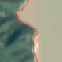 |
| Gravelly coastline | Shore segments are mostly striped, low brightness, uniform texture, earthy yellow or white, darker colour in tidal inundation areas, coastline location desirable where brightness or texture varies | 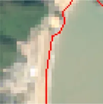 | |
| Estuarine coastline | Where the coastline is cut off by runoff at the point where the river enters the sea, the road bridge or tide gate closest to the mouth of the river may be used as the demarcation line; or the line joining the protruding points at the point where the river mouth suddenly widens may be used as the demarcation line | 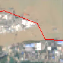 | |
| Silty coastline | This section of the coastline has a high degree of vegetation cover, which is bright green or dark green, and between the vegetation and the sea there are many exposed tidal flats, which are dark brown in colour, and the junction of the two colors is where the silt coastline is located. If there is no vegetation cover on the edge of the re-developed silt beach at the periphery of the artificial reclamation area, the outer boundary of the artificial reclamation area is regarded as the silt coastline | 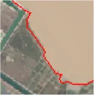 | |
| Artificial coastline | Cultured coastline | Farming coastlines are mainly man-made dykes, which appear bright white on remote sensing imagery, with regularly shaped field shaped ponds or cultivated land inside, which are blue-black or green in colour, and where the dyke is located is the coastline | 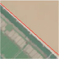 |
| Port Coastline | The harbor terminal, which appears as a bright white regular strip on the imagery and extends towards the sea side, should in principle have its external shape as the coastline. However, due to the limitation of the impact resolution, the line where it meets the land part is taken as the coastline in this study | 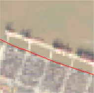 | |
| Construction coastline | This type of coastline is an embankment on the periphery of a built-up site, such as an industrial or residential site, which is purplish or pale pink in colour on the image, and is more irregular in shape, but has a distinct boundary with the sea, the boundary of which is the coastline | 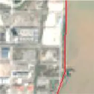 | |
| Protective coastline | This type of coastline is a seawall for tidal protection, a type of seawall is considered to be a coastline when it is a bright white strip on the image, with more dark brown mudflats developed on the seaward side, and a type of seawall is considered to be a coastline when the seawall on the seaward side of the reclaimed area has been closed but the interior is still seawater (or there is a limited amount of reclaimed area) | 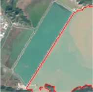 |
Coastline classification System.
3.2.2 Coastline fragmentation
Human reclamation activities occupy the natural coastline, resulting in the interruption of continuous and complete natural coastlines, becoming increasingly fragmented. The study uses the maximum length of continuous coastlines, the average coastline value, and the total number of coastline segments as indicators for measuring coastline fragmentation, in order to reveal the coastline fragmentation situation in the Yong-Tai-Wen region (Figure 2).
3.2.3 Coastline tortuosity
The tortuosity of the coastline is used to reflect the degree of curvature of a single coastline. Due to the influence of human development activities, artificial coastlines are relatively straight and regular, and the tortuosity is smaller than natural coastlines that are not affected by human activities. Therefore, the tortuosity of the coastline can to some extent reflect the impact of human reclamation and other development activities on the coastline in coastal areas. The calculation formula is as follows:
Among them, is the curvature of the coastline (dimensionless), is the actual length of the coastline within the selected section, and is the linear distance between the endpoints of the selected section (Li, 2022).
3.2.4 Intensity of coastline changes
In order to further analyze the changes in the coastline of the Yong-Tai-Wen region and reveal the impact of human activities on the coastline during the process of regional urbanization, a coastline intensity change index (LCI) was constructed by combining time variables. The calculation formula is as follows:Among them, is the intensity of coastline changes from to years, is the length of the coastline in years, is the length of the coastline in years.
4 Result
4.1 Spatiotemporal changes of the coastline
4.1.1 Change in coastline length
Overall, the coastline length in the Yong-Tai-Wen region shows a trend of “decrease increase decrease” (Figure 3), with a decrease in coastline length between 1980 and 1990; From 1990 to 1995, the length of its coastline increased, and between 1995 and 2000, the fluctuation in coastline length was relatively small, entering the first “plateau period”; After 2000, the length of the coastline rapidly decreased, forming a second “plateau period” between 2010 and 2015. At the same time, the total length of the coastline in the Yong-Tai-Wen region decreased from 1996 km in 1980 to 1918 km in 2020, with a decrease of 78 km. Among them, Taizhou City has the greatest contribution to the reduction of coastline length in the Yong-Tai-Wen region, with a decrease of 109 km in its coastline length in the 40 years since 1980.
FIGURE 3
Regarding regional coastline changes, Ningbo’s coastline has experienced fluctuations: it decreased between 1980 and 1990, increased from 1990 to 2000, and then continuously shrank after 2000. In contrast, the coastline lengths of Taizhou City and Wenzhou City display more distinct trends. From 1980 to 2020, Taizhou City’s coastline consistently decreased, while Wenzhou City’s coastline continuously increased.
Looking back at the rate of coastline change in the Yong-Tai-Wen region (Figure 4), the overall trend of the region is relatively similar to the regional trend, showing a trend of first increasing and then decreasing. Among them, from 1980 to 2010, the rate of coastline change in the Yong-Tai-Wen region, Ningbo city, and Taizhou city continued to accelerate, reaching its peak in 2010, at 6.38 km/yr, 3.81 km/yr, and 5.27 km/yr, respectively. After 2010, the rate of coastline change in all three regions slowed down; The peak rate of coastline change in Wenzhou City occurred in 2015, at 3.79 km/yr, and the overall change in rate also showed a trend of first increasing and then decreasing.
FIGURE 4
4.1.2 Change in coastline type
After establishing a coastal classification system for the Yong-Tai-Wen region (Table 1), the study categorized the coastline into natural and artificial segments (Figure 5). It also calculated the percentage of artificial coastlines within the entire Yong-Tai-Wen region, as well as specifically for Ningbo, Taizhou, and Wenzhou (Figure 6). This analysis provides insights into the impact of human development activities on the coastline during the region’s socio-economic growth and urbanization.
FIGURE 5
FIGURE 6
From 1980 to 2020, the proportion of artificial coastlines in the Ningbo-Taizhou-Wenzhou region, including Ningbo, Taizhou and Wenzhou, exhibited a consistent upward trend, with increases of 39.08%, 43.30%, 32.54%, and 39.92%, respectively. Notably, by 2020, Wenzhou had the highest proportion of artificial coastline, amounting to 70.40%.
It is evident that since the implementation of the reform and opening-up policy, the Ningbo-Taizhou-Wenzhou region has witnessed remarkable socio-economic growth and urbanization, significantly altering the types of coastlines within the region. Consequently, there has been a notable decline in the diversity of natural coastlines. Coastal development activities, including land reclamation, dike construction, and port development, have led to a substantial transformation of natural coastlines into industrial coastlines. Notably, cities like Ningbo and Wenzhou, which boast excellent port construction conditions, have experienced a more significant increase in the proportion of human-made and industrial coastlines.
4.1.3 Change in coastline fragmentation
During coastal development, humans inevitably occupy natural coastlines, leading to the disruption and fragmentation of originally contiguous natural coastlines. Consequently, this study conducted a statistical analysis of key metrics, including the maximum natural coastline length, average coastline length, and total number of coastline segments in the Yong-Tai-Wen region, to quantify the extent of coastline fragmentation. As shown in Table 2, between 1980 and 2020, the maximum natural coastline length in the Yong-Tai-Wen region decreased, displaying an overall downward trend. Concurrently, while the average coastline length decreased, the total number of coastline segments increased. These findings indicate that human development activities have progressively intensified coastline fragmentation in the Yong-Tai-Wen region. However, since 2010, the pace of fragmentation has slowed, with indicators like the increase in the maximum length of the natural coastline suggesting a slight deceleration. Nevertheless, the overall trend remains towards increasing fragmentation.
TABLE 2
| Year | Maximum length of continuous coastlines (km) | Average length of coastline (km) | Total number of coastline segments |
|---|---|---|---|
| 1980 | 149.22 | 10.13 | 197 |
| 1985 | 82.35 | 8.75 | 227 |
| 1990 | 76.56 | 7.37 | 269 |
| 1995 | 71.46 | 6.71 | 298 |
| 2000 | 70.22 | 6.51 | 307 |
| 2005 | 68.16 | 5.93 | 334 |
| 2010 | 42.04 | 5.93 | 327 |
| 2015 | 52.92 | 5.26 | 364 |
| 2020 | 50.77 | 4.83 | 397 |
Coastline fragmentation change in Yong-Tai-Wen region from1980 to 2020.
The reason behind this trend is that, in the early stages of reform and opening up, as the degree of openness increased, a significant influx of people poured into coastal areas, heightening the tension between human population and land resources. Consequently, reserve land resources such as coastal mudflats emerged as crucial development mediums to alleviate this tension. However, with the escalating human development activities, the natural coastline has become increasingly fragmented, while the artificial coastline exhibits a trend towards smaller but numerous segments, leading to a rise in the total number of regional coastlines. As environmental issues stemming from coastal development activities continue to worsen, coastal ecological concerns have garnered increasing attention. Notably, since 2012, when the country emphasized “ecological civilization construction,” various levels of local governments have actively responded by enacting numerous regulations and policies to restrict coastal development activities. Furthermore, they have undertaken initiatives such as vegetation protection and ecological restoration to safeguard and rejuvenate coastal ecosystems.
4.1.4 Change in coastline tortuosity
Without human intervention, natural coastlines tend to develop in a relatively unstructured manner, exhibiting tortuous and intricate characteristics. Conversely, artificial coastlines resulting from human activities like land reclamation from the sea tend to display straighter and smoother morphological traits. By analyzing the curvature of the coastline (Equation 1) in the Yong-Tai-Wen region (Figure 7), it was observed that from 1980 to 1990, the curvature of the coastline in this region steadily decreased. Subsequently, from 1990 to 1995, the tortuosity of the coastline experienced a brief rebound. However, after 1995, the tortuosity continued to decline, with a particularly rapid decrease occurring between 2005 and 2015. Finally, after 2015, the tortuosity of the coastline exhibited a slight increase.
FIGURE 7
4.1.5 Change in the intensity of coastline
The intensity of coastline changes (Equation 2) in the Yong-Tai-Wen region exhibits a prominent “W” shape (Figure 8), characterized by significant fluctuations. During the period from 1980 to 1990, the intensity of coastline change registered a negative value, with the absolute magnitude of the change first escalating and subsequently waning. Subsequently, from 1990 to 2000, the change intensity turned positive, again following a trend of initial growth followed by a decline. Then, from 2000 to 2020, the intensity of coastline change resumed a negative trend, with the absolute value of change intensity initially increasing and then decreasing, peaking in 2010.
FIGURE 8
4.2 Correlation between socio-economic development and coastline changes in the Yong-Tai-Wen region
4.2.1 Analysis of the correlation between GDP and coastline changes
The study selected GDP and coastline length as two key indicators for regression analysis in the Yong-Tai-Wen region (Figure 9). The findings reveal a pronounced negative correlation between GDP and coastline length in Ningbo and Taizhou cities within the region, whereas in Wenzhou, a strong positive correlation is observed. Further investigation reveals that Ningbo and Taizhou are home to numerous bays abundant in mudflat resources, including Hangzhou Bay and Sanmen Bay. These mudflat areas, representing crucial reserve land resources, have significantly contributed to the regional development process. Additionally, compared to bedrock coasts, the mudflat and other muddy coasts in these areas have witnessed more intense human activity. While this has spurred the rapid growth of the local social economy, it has also significantly altered the local coastline’s character, resulting in a straighter coastline and a reduction in its overall length.
FIGURE 9
Furthermore, the study delved into the relationship between GDP and the proportion of artificial coastlines in the Yong-Tai-Wen region (Figure 10). It revealed a robust positive correlation between GDP and the proportion of artificial coastlines, both at the regional level and at the prefecture-level city scale. This suggests that coastal zones are increasingly being developed to mitigate severe land conflicts caused by human activities, resulting in a heightened degree of artificial coastal development. Nevertheless, the economic benefits accruing from this development process also contribute significantly to the region’s socio-economic growth to a certain extent.
FIGURE 10
4.2.2 Correlation analysis between urban land use and coastline changes
To further analyze and elucidate the intricate connection between urbanization processes and regional coastline changes, the study delved deeper into the correlation between urban land use and coastline length (Figure 11). Upon examination, it emerged that the correlation between urban land use and coastline length mirrors the representation of GDP. Specifically, a robust negative correlation was observed between urban land use and coastline length in the Yong-Tai-Wen region and Taizhou City, with Taizhou City exhibiting a more pronounced correlation. Conversely, in Ningbo, the correlation between urban land use and coastline length was not significant. This suggests that while the exploitation of coastline resources has aided urbanization to some degree, it hasn't been the primary driver of Ningbo’s urbanization process. On the other hand, Wenzhou City exhibited a strong positive correlation between urban land use and coastline length, indicating that Wenzhou’s coastline has been gradually expanding amidst its urbanization journey.
FIGURE 11
Furthermore, the study delved into the correlation between urban land use and the proportion of artificial coastlines in the Yong-Tai-Wen region (Figure 12). The analysis revealed a robust positive correlation between urban land use and the proportion of artificial coastlines in the Yong-Tai-Wen region, Ningbo city, Taizhou city, and Wenzhou city. This observation underscores the significant impact of the urbanization process in the Yong-Tai-Wen region, which has altered the natural attributes of the original coastline to some extent, leading to a steady increase in the proportion of artificial coastlines in the region. Nevertheless, the development and utilization of coastline resources have simultaneously breathed new life into the urbanization process of the region, infusing it with renewed vitality.
FIGURE 12
4.2.3 Analysis of the correlation between cultivated land and coastline changes
In addition, the study scrutinized the intricate relationship between cultivated land, coastline length, and the proportion of artificial coastlines in the Yong-Tai-Wen region (Figures 13, 14). Regarding the correlation between cultivated land and coastline length, while a positive trend is observed in the Yong-Tai-Wen region, Ningbo city, and Taizhou city, it remains relatively insignificant. Conversely, in Wenzhou city, a non-significant negative correlation is evident. Turning our attention to the correlation between the proportion of cultivated land and artificial coastline, a robust negative correlation is consistently observed across all four regions.
FIGURE 13
FIGURE 14
Taking into account the realities of each region and their respective farmland policies, we discovered that maintaining the overall balance of cultivated land is crucial for each locale. As socio-economic development and urbanization progress, it becomes inevitable that cultivated land will be converted to other, more developmentally valuable land types. Therefore, it's imperative to harmonize the allocation of reserve land resources, such as coastal mudflats, to uphold the dynamic equilibrium of the total cultivated land area. During this transition, human intervention in coastline development remained relatively minimal, resulting in insignificant changes to the overall coastline length. Nevertheless, these coastlines underwent a transformation from their natural state to artificial ones, thereby increasing the proportion of artificial coastlines. Consequently, while the correlation between cultivated land area and coastline length may not be significant in terms of quantitative analysis, a strong negative correlation is evident with the proportion of artificial coastlines.
5 Discussion
5.1 Impact of policies on coastline changes
During our analysis of the spatiotemporal coastline changes in the Yong-Tai-Wen region, notable turning points emerged in 2010 and 2015, potentially influenced by the implementation of relevant policies. Consequently, we delved further into significant maritime policies introduced since 1980 (Table 3). Prior to 2010, policies issued by both the national and Zhejiang provincial governments emphasized marine environmental and wetland protection, with a preponderance of national-level macro policies. Post-2010, however, the focus shifted towards coastal development activities, particularly reclamation. From the perspective of coastline utilization and development, these latter policies exerted a more direct and profound influence. Furthermore, since 2012, when China elevated ecological civilization construction to a national strategy, the nation has placed increasing emphasis on coastal environmental protection and ecological restoration. Concepts such as “green waters and green mountains are golden mountains and silver mountains” have gained deeper roots in public consciousness, greatly aiding in the efforts to safeguard the ecological environment of coastal regions.
TABLE 3
| Year | Policies | Administrative level |
|---|---|---|
| 1982 | Marine Environmental Protection Law of the People’s Republic of China | China |
| 1990 | Regulations of the People’s Republic of China on the Prevention and Control of Pollution Damage to the Marine Environment Caused by Coastal Engineering Construction Projects | China |
| 1992 | Join the Ramsar Convention | China |
| 1994 | The first national wetland resources special survey | China |
| 1999 | Revision of the Marine Environmental Protection Law of the People’s Republic of China | China |
| 2000 | Action Plans of China Wetland Protection | China |
| 2000 | Ecological Environment Construction Plan of Zhejiang Province | Zhejiang |
| 2003 | National Wetland Protection Engineering Plan (2002-2030) | China |
| 2004 | Regulations of Zhejiang Province on Marine Environmental Protection | Zhejiang |
| 2004 | Research on Wetland Protection Legislation in China | China |
| 2004 | Regulations of Zhejiang Province on Marine Environmental Protection | China |
| 2006 | Wetland conservation planning of Zhejiang Province (2006–2020) | Zhejiang |
| 2011 | Management Measures for Reclamation Plan | China |
| 2012 | Marine Environmental Protection Plan of Fujian Province (2011–2020) | Zhejiang |
| 2012 | Regulations of Zhejiang Province on Wetland Protection | China |
| 2012 | Ecological civilization construction | China |
| 2016 | Control Measures for Reclamation | China |
| 2017 | National Coastal Shelterbelt System Construction Project Plan (2016–2025) | Zhejiang |
| 2018 | Revision of the Regulations of Zhejiang Province on the Administration of Reclamation | Zhejiang |
| 2019 | Implementation Plan for Strengthening Coastal Wetland Protection and Strictly Controlling Reclamation in Zhejiang Province | Zhejiang |
Major sea-related policies since 1980.
Concurrently, in regards to coastal development projects, the initial disorganized and extensive approach has gradually transformed into an orderly and intensive one. This transition has resulted in a rigorous and rational coastal land approval process that spans multiple levels and is bolstered by a robust monitoring and supervision system. This system serves as a crucial safeguard for the sustainable development of coastal regions. Consequently, the coastline changes observed in the Yong-Tai-Wen region exhibit distinct phased characteristics, with 2010 marking a pivotal turning point.
5.2 Impact of economic models on coastline changes
During our analysis of various cities within the Ningbo-Taizhou-Wenzhou region, we observed distinct differences in the correlation between socio-economic development and coastal changes among Ningbo, Taizhou, and Wenzhou. These disparities are likely attributed to their unique socio-economic development models (Figure 9, Figure 10).
Boasting numerous natural harbors and a robust commercial culture, Ningbo has capitalized on the deepening of reform and opening up to rapidly emerge as one of the world’s foremost free trade ports. A key aspect of its economic development model is the “mixed economy model,” which incorporates the strengths of diverse economic models (Zheng and Ju, 2005). This model, centered around a leading state-owned economy, fosters mutual integration and shared prosperity across various ownership economies, driving the rapid economic growth of the region. Through extensive coastal development projects like port construction, Ningbo has accumulated significant primitive capital. Leveraging its cultural strengths and strategic location, the city has also embarked on intensive coastal tourism development, continuously promoting the sustainable utilization and development of its coastal resources.
The economy of Taizhou, primarily driven by township enterprises, has traversed three distinct stages: stock cooperation, individual private ownership, and the company system. These transitions have culminated in the formation of a “three people” economic model, where the people occupy a central role, the private sector serves as the backbone, and private social enterprises lead the way (Zheng, 2001). In the economy’s initial phase, based on stock cooperation, numerous labor-intensive industries took root in Taizhou’s coastal regions, significantly altering the city’s coastline. Subsequently, Taizhou has persisted in technological innovation and the optimization and upgrading of its industrial structure, resulting in a slight decrease in the artificial shaping of the coastline.
The economic development model of Wenzhou City is characterized by a vast market for small commodities, an extensive supporting system for small accessories, a significant industry for small products, extensive collaboration among small enterprises, and a large aggregation of small capital (Huang, 2009). Throughout its socio-economic development, Wenzhou has primarily focused on private enterprises, particularly household industries, with a comparatively smaller presence of marine industries. The challenges associated with developing bedrock coastline have limited its exploitation and utilization, resulting in a more natural coastline development trend. Consequently, from 1980 to 2020, the length of Wenzhou’s coastline has continuously increased. Notably, in the analysis process, the representation of Wenzhou City differs significantly from the other two prefecture-level cities.
6 Conclusion
Based on multi-source satellite remote sensing data, the study interpreted and analyzed the coastline information of the Yong-Tai-Wen region spanning from 1980 to 2020. We selected indicators such as coastline fragmentation, coastline tortuosity, and coastline change intensity to assess the region’s coastline changes. Additionally, to gain a deeper understanding of the link between socio-economic development and the spatiotemporal variations of the coastline, we conducted a correlation analysis between GDP, urban land area, cultivated land area, coastline length, and the proportion of artificial coastlines. The results showed that:
(1) From 1980 to 2020, the coastline of the Yong-Tai-Wen region exhibited a fluctuating trend, initially decreasing, then increasing, and finally decreasing again. Notably, Taizhou experienced the most pronounced decrease in coastline length, amounting to 109.21 km. Concurrently, the region saw a persistent rise in the degree of artificial coastline, with significant increases in the proportion of artificial coastline in Ningbo-Taizhou-Wenzhou, specifically 39.08% in Ningbo, 43.30% in Taizhou, and 39.92% in Wenzhou. Wenzhou also experienced a notable increase of 32.54% in its artificial coastline proportion. In addition, the coastline fragmentation in the Yong-Tai-Wen region progressively intensified, resulting in a more tortuous coastline. The intensity of coastline changes exhibited notable fluctuations over this period, with the maximum absolute value of change intensity occurring in 2010.
(2) At the scale of the Yong-Tai-Wen region, there exists a robust negative correlation between the length of the coastline and both GDP and urban land use. However, the correlation with cultivated land area remains relatively low. Conversely, there is a significant positive correlation between the proportion of artificial coastlines and both GDP and urban land use. Interestingly, a strong negative correlation is observed between the proportion of artificial coastlines and cultivated land area.
(3) At the prefecture-level city scale, there is a pronounced negative correlation between the length of the coastline in Ningbo and GDP, along with a certain degree of correlation with urban land use. In Taizhou, the length of the coastline exhibits a strong negative correlation with both GDP and urban land use. Conversely, in Wenzhou, the length of the coastline demonstrates a strong positive correlation with GDP and urban land use. However, the correlation between the length of the coastline and cultivated land area remains relatively low. Regarding the proportion of artificial coastlines, Ningbo City and Taizhou City exhibit similar correlation characteristics to the overall representation of the Yong-Tai-Wen region. Specifically, the proportion of artificial coastlines in these cities is positively correlated with GDP and urban land use, indicating a close relationship with socio-economic development. In contrast, in Wenzhou City, the proportion of artificial coastlines displays a complex pattern, with positive correlation with GDP and urban land but a negative correlation with cultivated land.
Statements
Data availability statement
The original contributions presented in the study are included in the article/supplementary material, further inquiries can be directed to the corresponding author.
Author contributions
QH: Investigation, Validation, Writing–review and editing. YiL: Software, Validation, Writing–original draft, Writing–review and editing. SA: Conceptualization, Investigation, Software, Validation, Writing–original draft. YC: Funding acquisition, Methodology, Supervision, Writing–original draft. YoL: Validation, Writing–review and editing.
Funding
The author(s) declare that financial support was received for the research, authorship, and/or publication of this article. This research was supported by the Ningbo Social Science Planning Project (G2023-2-59), The Science and Technology Major Project of Ningbo (2021Z181), National Natural Science Foundation (42276234).
Acknowledgments
The authors thank the anonymous reviewers who gave you their time, expertise, and feedback to improve the article more precise, clear, accurate, and relevant.
Conflict of interest
The authors declare that the research was conducted in the absence of any commercial or financial relationships that could be construed as a potential conflict of interest.
Publisher’s note
All claims expressed in this article are solely those of the authors and do not necessarily represent those of their affiliated organizations, or those of the publisher, the editors and the reviewers. Any product that may be evaluated in this article, or claim that may be made by its manufacturer, is not guaranteed or endorsed by the publisher.
References
1
CaiH.LiC.LuanX.AiB.YanL.WenZ. (2022). Analysis of the spatiotemporal evolution of the coastline of Jiaozhou Bay and its driving factors. Ocean & Coast. Manag.226, 106246. 10.1016/J.OCECOAMAN.2022.106246
2
DingH. (2006). Research on land use change, driving mechanism and forecasting model in developed coastal economic regions of China [master's thesis]. Zhejiang University. [Hangzhou (Zhejiang)].
3
HasanM. K.KumarL. (2021). Yield trends and variabilities explained by climatic change in coastal and non-coastal areas of Bangladesh. Sci. Total Environ.148814, 148814. 10.1016/J.SCITOTENV.2021.148814
4
HouX.WuT.HouW.ChenQ.WangY.YuL. (2016). Characteristics of coastline changes of Chinese mainland since the early 1940s. Sci. Sin. Terrae8, 1065–1075. 10.1360/N072015-00268
5
HuangQ. (2009). Developing industrial clusters and strengthening private economy-- enlightenment of Wenzhou economic model to the economic development of guiyang. Theory Contemp.6, 47–48.
6
LiJ. (2020). Development and evaluation of coastal zone resources. Beijing: China Science Publishing & Media Ltd.(CSPM) Press.
7
LiX.YuanC.LiY. (2013). Remote sensing monitoring and spatial-temporal variation of Bohai Bay coastal zone. Remote Sens. Land Resour.2, 156–163. 10.6046/gtzyyg.2013.02.26
8
LiY. (2022). Extraction and spatio-temporal evolution analysis of Wenzhou coastline based on remote sensing images [master's thesis]. Nanchang University. [Nanchang(Jiangxi)].
9
LinJ.WuT. (2021). Analysis on the temporal and spatial change of the utilization degree of the continental coastal zone in fujian province since the 1940s. Sci. & Technol. Rev.4, 104–111. 10.3981/j.issn.1000-7857.2021.04.018
10
MujabarP. S.ChandrasekarN. (2013). Shoreline change analysis along the coast between Kanyakumari and Tuticorin of India using remote sensing and GIS. Arabian J. Geosciences3, 647–664. 10.1007/s12517-011-0394-4
11
RenZ.ZhanC.YuJ.GengW.CaoY.WangQ. (2022). Analysis of coastline changes in the abandoned sub-delta of Diaokou over the past 50 years. MARLINE Sci.12, 8–19. 10.11759/hykx20220327001
12
WhiteS. A.WangY. (2003). Utilizing DEMs derived from LIDAR data to analyze morphologic change in the North Carolina coastline. Remote Sens. Environ.1, 39–47. 10.1016/S0034-4257(02)00185-2
13
WuY.LiuZ. (2019). Research progress on methods of automatic coastline extraction based on remote sensing images. Natl. REMOTE Sens. Bull.4, 582–602. 10.11834/jrs.20197410
14
Zhejiang Statistical Yearbook (2021). Zhejiang provincial Statistics Bureau.
15
ZhengH.JuF. (2005). On the development model of Ningbo mixed economy. J. Zhejiang Wanli Univ.2, 141–143.
16
ZhengJ. (2001). Undertaking the gradient process of Industry and constructing the Economic pattern of ‘three people’- A rational reflection on the Economic Development Model of Taizhou. Zhejiang Econ.5, 24–25.
17
ZongS.HuY.ZhangY.WangW. (2021). Identification of land use conflicts in China's coastal zones: from the perspective of ecological security. Ocean Coast. Manag.213, 105841. 10.1016/J.OCECOAMAN.2021.105841
Summary
Keywords
coastline, socio-economic development, spatio-temporal variation, correlation, Ningbo-Taizhou-Wenzhou region
Citation
Huang Q, Li Y, Ai S, Chen Y and Liu Y (2024) Impact of regional economic development on the spatiotemporal changes of coastlines: a case study of Ningbo-Taizhou-Wenzhou region. Front. Earth Sci. 12:1428097. doi: 10.3389/feart.2024.1428097
Received
05 May 2024
Accepted
01 August 2024
Published
16 August 2024
Volume
12 - 2024
Edited by
Marcelo Cohen, Federal University of Pará, Brazil
Reviewed by
Marlon Carlos França, Federal Institute of Espírito Santo (IFES), Brazil
Christian Spreafico, University of Bergamo, Italy
Updates
Copyright
© 2024 Huang, Li, Ai, Chen and Liu.
This is an open-access article distributed under the terms of the Creative Commons Attribution License (CC BY). The use, distribution or reproduction in other forums is permitted, provided the original author(s) and the copyright owner(s) are credited and that the original publication in this journal is cited, in accordance with accepted academic practice. No use, distribution or reproduction is permitted which does not comply with these terms.
*Correspondence: Yongchao Liu, liuyongchao@nbu.edu.cn
Disclaimer
All claims expressed in this article are solely those of the authors and do not necessarily represent those of their affiliated organizations, or those of the publisher, the editors and the reviewers. Any product that may be evaluated in this article or claim that may be made by its manufacturer is not guaranteed or endorsed by the publisher.