
95% of researchers rate our articles as excellent or good
Learn more about the work of our research integrity team to safeguard the quality of each article we publish.
Find out more
ORIGINAL RESEARCH article
Front. Earth Sci. , 25 January 2024
Sec. Structural Geology and Tectonics
Volume 12 - 2024 | https://doi.org/10.3389/feart.2024.1351970
This article is part of the Research Topic Sichuan-Tibet Traffic Corridor: Fundamental Geological Investigations and Resource Endowment - Volume II View all 7 articles
 Cheng Liao1,2
 Mingjian Liang1,2*Han Chen1,2Zebin Mao3*Weiwei Wu1,2Yue Gong1Hong Zuo1,2Shuhuai Liu4Tian Li1,2Zhongyang Li5
The Garzê–Yushu fault is a large active NW-trending strike-slip fault on the Tibetan Plateau, along which strong earthquakes have frequently occurred historically. Together with the Xianshuihe fault, the Garzê–Yushu fault constitutes the northern boundary of the Sichuan–Yunnan block, and it is also the boundary between the Bayan Har and Qiangtang blocks. The Abuduo fault is a near E–W-trending fault on the southern side of the Garzê–Yushu fault. Through remote sensing image interpretation and field seismic geological investigations, this study found a series of left-lateral displacement landforms and well-preserved seismic surface rupture zones along the Abuduo fault, extending over a distance of approximately 65 km from Abuduo through Yushu and Qinghai to Selikou Village. According to the geological and geomorphological evidence, the Abuduo fault is considered a left-lateral strike-slip fault with Holocene activity, which has tectonic conditions suitable for breeding and generating strong earthquakes. Additionally, the eastward extension of the Abuduo fault is likely to intersect the Garzê–Yushu fault and thereby decompose its horizontal sliding deformation.
The Tibetan Plateau is the region with the strongest modern tectonic and strong earthquake activities in China (Deng et al., 2002). Available historical records indicate that the region has experienced 18 earthquakes with magnitude of ≥M8.0 and more than 100 earthquakes with magnitude of M7.0–7.9 (Deng et al., 2014). The Garzê–Yushu fault, which is a large active NW-trending strike-slip fault on the Tibetan Plateau, is also an important boundary fault of the Sichuan–Yunnan block (Wen et al., 2003; Chen et al., 2008). The Garzê–Yushu fault is also the demarcation line between the Bayan Har block and the Qiangtang block, and it accommodates the relative motions of those blocks and the Sichuan–Yunnan block in conjunction with the Xianshuihe fault and the Fenghuoshan fault (Qiao et al., 2004; Huang et al., 2015). Several strong earthquakes have occurred on the Garzê–Yushu fault since historical records began, e.g., the M8.0 earthquake in Manigange (1320), Ms7.5 earthquake in Dangjiang (1738), Ms7.7 earthquake in Garzê (1854), Ms7.0 earthquake in Luoxu (1896), and M7.1 earthquake in Yushu (2010) (Zhou et al., 1996; Wen et al., 2008; Lin et al., 2011; Li et al., 2016; Lv et al., 2017), which fully indicate that the Garzê–Yushu fault is a boundary fault with strong earthquake activity. Owing to the strong earthquake activity on the Garzê–Yushu fault, related research is reasonably abundant and not only includes 1:50,000 strip mapping and scientific investigation of its active faults, but also covers fault geometry imaging and analyses of slip rate, paleoseismicity, and earthquake risk (Li et al., 1995; Zhou et al., 1997; Wen et al., 2003; Xu et al., 2003; Peng et al., 2006; Lin et al., 2011; Wu et al., 2014; Shi et al., 2016).
A series of near E–W-trending strike-slip faults exists on the southern side of the NW-trending Garzê–Yushu boundary fault, such as the Batang fault, Abuduo fault, and Maisu fault, which are dispersed within the block and might intersect the Garzê–Yushu fault to the east. Among them, the Batang fault has been studied for its Late Quaternary activity, slip rate, and tectonic importance (Huang et al., 2015; Wang et al., 2015; You et al., 2016). Zuo et al. (2022) undertook research on the geometric structure and Late Quaternary activity of the Maisu fault, and relevant field data on its slip rate have been acquired and are in the process of being compiled. In contrast, other than for some remote sensing image interpretation research, few studies have investigated the Abuduo fault, and field seismological and geological investigation data are notably lacking (Wu et al., 2014; Li et al., 2023). Remote sensing image interpretation suggests that the Abuduo fault, the main trace of which is the near E–W-trending Abuduo section in the eastern part of the Ziqu River, has total length of approximately 110 km, and the solution of the seismic source mechanism indicates that it is a left-lateral strike-slip fault (Wu et al., 2014). On the basis of remote sensing image data, Wu et al. (2014) classified the Abuduo fault as an intracrustal active fault zone with moderate to weak activity owing to the amount of left-lateral displacement, degree of development of the Quaternary basin, and present-day earthquake activity. Additionally, no geometric image of the Abuduo fault is found in the 1:50,000 active fault distribution map of the Garzê–Yushu fault (Garzê–Batang section) (Zhou et al., 1997). As a strike-slip fault that may intersect with the Garzê–Yushu fault to the east and decompose the slip rate of the Garzê–Yushu fault, the geometrical image and activity of the Abuduo fault are of great significance for the study of the characteristics of the sliding rate distribution of the various segments of the Garzê–Yushu fault and the earthquake risk of the Abuduo fault. Based on this, The detailed image interpretation and field seismological–geological investigation of the Abuduo fault conducted in this study both revealed that the Abuduo rupture has total length of approximately 110 km, and identified important new activity traces and well-preserved seismic surface rupture zones, especially in the Shasailong–Xiarike–Quechada–Shanikuo area. The relationship between the surface rupture and the magnitude of associated earthquakes was investigated using empirical theoretical formulas. Geomorphological evidence indicates that the Abuduo fault is a left-lateral strike-slip fault with Holocene activity.
The study area (Figure 1) is located at the eastern edge of the Tibetan Plateau, a series of fault zones developed within the Tibetan Plateau during the Cenozoic as a result of the strong collision between the Indian and Eurasian plates, such as the Kunlunshan fault zone, Altyn fault zone, Xianshuihe fault zone, and Garzê–Yushu fault zone, developed during the Cenozoic period owing to the collision between the Indian and Eurasian plates. These faults divide the Tibetan Plateau into several long blocks that include the Qilianshan block, Qaidam block, Bayan Har block, and Qiangtang block, which includes the Abuduo fault (Figure 1) (Zhang et al., 2002; Zhu et al., 2004; Huang et al., 2015). The study area (Figure 2), which is on the northwestern side of the Sichuan–Yunnan block, between the Bayan Har and Qiangtang blocks, is influenced by the movement of the regional blocks and it has mainly developed NW-trending and near E–W-trending fault systems. The NW-trending Garzê–Yushu fault is a large Holocene active strike-slip boundary fault with Holocene activity, which together with the Xianshuihe fault constitutes the northern boundary of the Sichuan–Yunnan block, and is also the boundary between the Bayan Har and Qiangtang blocks. Its slip rate since the Late Quaternary has been estimated to range from 5.5 ± 0.5 to 14 ± 3 mm/a (Li et al., 1995; Zhou et al., 1996; Wen et al., 2003; Xu et al., 2003; Peng et al., 2006). Historically, a number of strong earthquakes have occurred on this fault, e.g., the M8.0 earthquake in Manigange, Sichuan Province (1320), Ms7.5 earthquake in Dangjiang, Qinghai Province (1738), and Ms7.7 earthquake in Garzê, Sichuan Province (1854) (Zhou et al., 1997; Lin et al., 2011; Li et al., 2016; Lv et al., 2017). Latest research on the middle section of the NW-trending Wudaoliang–Changshagongma fault within the Bayan Har block indicates that it is a left-lateral strike-slip fault with Holocene activity that has had an average horizontal slip rate of 2.55 ± 0.50 mm/a since the Late Quaternary, and four paleoseismic events have been revealed by trench survey (Liang et al., 2022; Liang et al., 2023). Among the three near E–W-trending faults within the study area, the Batang fault is a left-lateral strike-slip fault with Holocene activity that has had a horizontal slip rate of 2.1–3.9 mm/a since the Late Quaternary, and presents a paleoseismic recurrence cycle of approximately 1,500 years (Huang et al., 2015; You et al., 2016). The Maisu fault is on the southern side of the Garzê–Yushu fault, and geomorphological evidence suggests that it also has Holocene activity, with a predominant left-lateral characteristic (Zuo et al., 2022). Seismological–geomorphological evidence associated with the Abuduo fault also indicates that it is a left-lateral strike-slip fault with Holocene activity, and that it extends eastward to intersect the Garzê–Yushu fault near Zhengke. The NW-trending and E–W-trending active fault systems in the region constitute the tectonic background of the study area, and influence both regional tectonic deformation and earthquake activity.
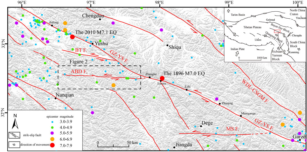
FIGURE 1. Distribution of the main faults and earthquakes within the study region. GZ-YS F, Garzê–Yushu fault; ABD F, Abuduo fault; BT F, Batang fault; MS F, Maisu fault; WDL-CSGM F, Wudaoliang–Changshagongma fault.
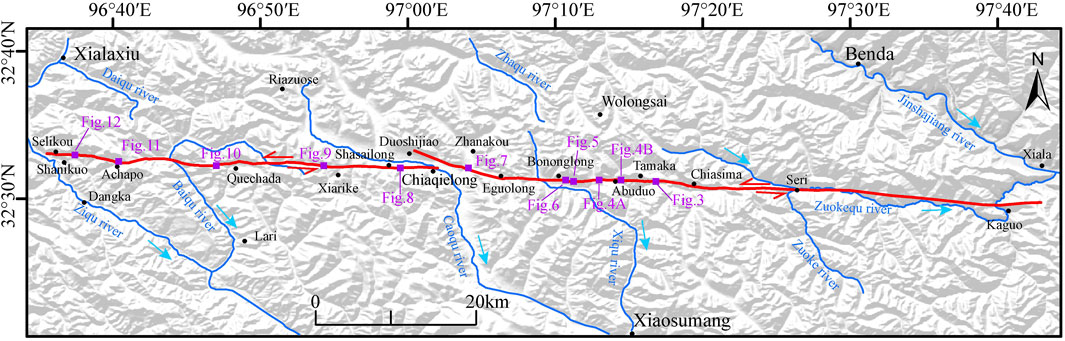
FIGURE 2. The geometry of the Abuduo fault. The purple solid squares represent the survey sites in the field.
The present-day seismicity in the study area is unevenly distributed. Seismicity is concentrated in the northwest of the region and in the Garzê area in the southeast, and earthquakes with magnitude of ≥M6.0 have been mainly concentrated on the Garzê–Yushu fault (Figure 1), e.g., the Luoxu M7.0 earthquake in Shiqu, Sichuan Province in 1896, Yushu M7.1 earthquake in Yushu, Qinghai Province in 2010, and Yushu M6.5 earthquake in 1738. The seismicity in other areas is sparse and mainly reflects events with magnitude of M5.0 and below. In 1979, a stronger earthquake (M6.2) occurred approximately 15 km to the south of the Abuduo fault, but the seismicity of the Abuduo fault generally remains dominated by sporadic small earthquakes of M5.0 or less, i.e., M4¾ earthquakes in 1925 and 1930, and M3.6 earthquakes in 2021 and 2022.
In this study, high-resolution satellite images (Google Earth™) were used for visual interpretation of the fault. Then, the fault location, tendency, segmentation, and other geometric structures and typical tectonic landform points were identified. The main interpretation was based on fault troughs, linear traces, fault scarps, associated fault plug ponds and fault springs, faulted gullies, river terraces, and ridges. Field seismological–geological investigation was performed on the interpreted fault linear traces and typical tectonic landforms, and various linear traces and tectonic landforms were obtained by tracing the direction of the fault according to in situ fault linear traces and tectonic landforms, determining the location and alignment of the investigated points, taking photographs of the landforms, and obtaining recordings. Combined with the image-based interpretation of the geometric structures, the spatial distribution of the fault was drawn and the geometric image of the fault was obtained. Additionally, the magnitude of displacement of typical displacement landforms was measured and recorded in situ using a tape measure. On the basis of the features of displacement landforms and the existence of a seismic surface rupture, the latest activity of the fault was determined.
High-precision, high-resolution topographical and geomorphological data can delineate subtle surface fine-scale structures and represent the basis for quantitative study of active tectonics (Zielke et al., 2010). In this study, a small uncrewed aerial vehicle (UAV) was used in the field to conduct photogrammetric mapping of typical tectonic landforms. Agisoft PhotoScan software, which integrates SfM algorithms, was used for modeling to obtain high-precision, high-resolution orthophotos (Ai et al., 2018; Li et al., 2021), and a digital elevation model data with resolution of up to 2 cm/pixel was used to determine the subtler fine-scale structure of the ground surface. The high-resolution topographical and geomorphological data were used to reassess the magnitude of the displacement of the typical dislocated landforms, and were compared with the in situ field tape measurements to minimize measurement errors.
On the basis of remote sensing image interpretation and seismogeological survey, it was determined that the Abuduo fault starts at Kaguo Village (Jiangda County, Xizang Province) in the east and runs westward through Seri Village, Tamaka, Abuduo, Eguolong, Ehaiaqielong, Shasailong, Quechada, and Achapo, and ends at Selikou Village (Yushu City, Qinghai Province), with elevation of 4000–5,000 m and total length of 110 km. The seismogeological survey covered the area from Tamaka to Selikuo Village (Figure 2). The fault is divided into two branches, namely the east and west branches, and a small pull-apart basin has formed at the branch. Remote sensing image interpretation revealed that the Abuduo fault retains a reasonably linear trace, especially along the Shasailong–Xiarike–Quechada–Achapo–Shanikuo section. The field seismological–geological survey of this study found a 65-km seismic surface rupture of the Abuduo fault, which started at Abuduo and disappeared near Selikou Village. The relevant figures associated with the field seismological–geological survey sites are labeled in Figure 2.
Approximately 2.5 km to the southeast of Tamaka, in the high mountains of the canyon, the Abuduo fault cuts across the ridge with a more pronounced fault trace, forming a series of reverse troughs, and along the fault zone collapse, landslides are more developed (Figure 3). The area to the east of the Abuduo fault Tamaka is close to the Jinshajiang River. Due to the influence of related geological processes, the landforms in this area are mainly mountains and canyons, and the transportation is inconvenient. The geological landforms investigation mainly takes remote sensing interpretation.
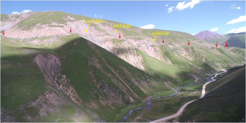
FIGURE 3. Fault trace of the Abuduo fault to the southeast of Tamaka.
Tectonic landforms are evident in the vicinity of Abuduo and the linear trace of the fault is clear. The fault can be seen along a road 2 km to the east of Abuduo, passing from the foot and slope of the mountain and cutting through the fore-mountain diluvial fan, forming a fault scarp and a fault trough (Figure 4A). Alongside a river 200 m to the southeast of Abuduo, the fault cuts across the ridge to form a pass landform, and cuts through the river terrace and a distinct fault spring is developed on the first terrace (T1) (Figure 4B).
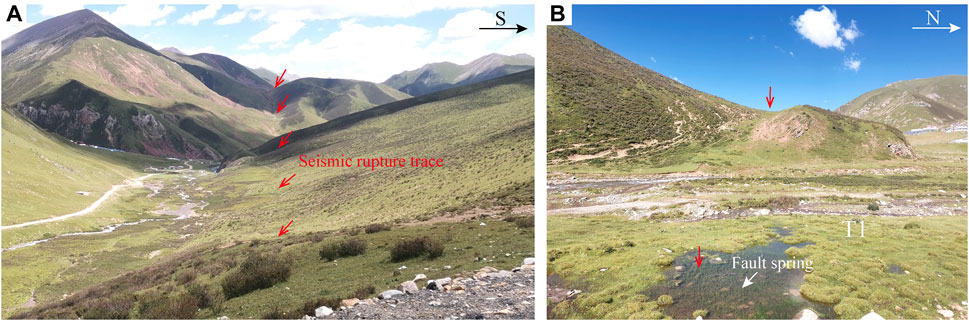
FIGURE 4. Geomorphological features of the Abuduo fault near Abuduo: (A) the seismic rupture trace and (B)The pass landform and a fault spring.
Approximately 1.6 km to the southeast of Bononglong, the Abuduo fault cuts through the ridge, gully, and gully wall, with an obvious fault trace forming fault troughs and reverse troughs, and a left-lateral displacement of the gully wall with large displacement (approximately 41 m) (Figure 5). Approximately 0.8 km to the southeast of Bononglong, the fault cuts across the fore-mountain diluvial fan to form a more distinct linear trace, and a fault spring is developed where the fault passes through (Figure 6).
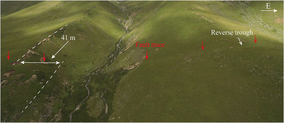
FIGURE 5. Geological and geomorphological features of the Abuduo fault 1.6 km to the southeast of Bononglong.
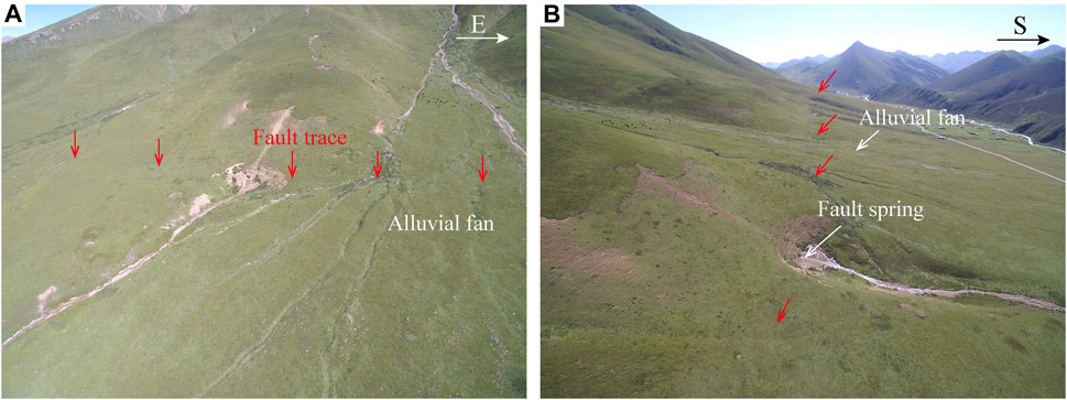
FIGURE 6. Geological and geomorphological features of the Abuduo fault 0.8 km to the southeast of Bononglong. (A) alluvial, (B) fault spring.
Adjacent to the road approximately 2.3 km to the south of Zhanakou, the Abuduo fault has developed notable surface rupture and displacement landforms. The topography and geomorphology of this area, mapped using the small UAV and Agisoft PhotoScan software (Figures 7A, C), reveal an obvious linear trace of the fault. The Abuduo fault cuts across the river, creating a major seismic surface rupture on the hillside to the west of the road, which cuts across the ridge to form a pass landform and continues westward (Figure 7D). The fault cuts across the secondary terrace of the river (T2), and the left-lateral displacement of approximately 3.9 m (Figure 7B) creates a distinct displacement landform. Additionally, fault springs are developed at the crossing point of the fault. Evidence from the Zhanakou geomorphological survey site suggests that the Abuduo fault has experienced reasonably recent activity and that the nature of its movement has left-lateral strike-slip characteristics.

FIGURE 7. Seismic surface rupture and displacement geomorphology 2.3 km to the south of Zhanakou: (A) high-precision orthophoto, (B) secondary terrace dislocated by 3.9 m, (C) high-precision topographical and geomorphological map, and (D) seismic rupture trace.
Remote sensing image interpretation reveals that the Abuduo fault retains a reasonable linear trace, which is particularly obvious in the Shasailong area. The fault runs from the foothill zone through the development of an alluvial fan, which can be seen as an obvious fault trough, together with a gully, terrace displacement, and other geomorphic phenomena. Preliminary assessment suggests that the magnitude of the gully displacement is up to 22.5 m (Figure 8).
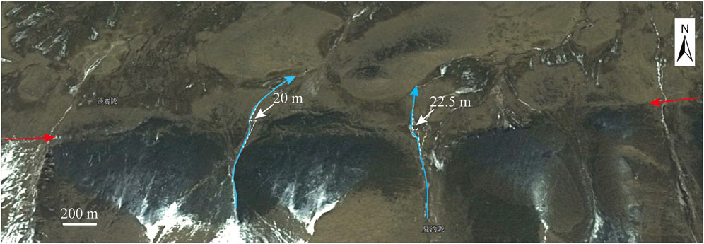
FIGURE 8. Fault trace of the Abuduo fault in the Shasailong area. The image was obtained from Google Earth.
Very distinct tectonic landforms and an obvious linear trace of the fault are developed near a path approximately 2 km to the northwest of Xiarike. The topography and geomorphology of the site were mapped using the small UAV, and a high-precision topographical and geomorphological map of the area was generated using Agisoft PhotoScan software (Figure 9A), in which the linear trace of the fault is clearly visible. On the western side of the road, the Abuduo fault cuts across the hillside and ridge, creating distinct linear troughs and small marshes, a pass landform, and fault springs that are developed in beads along the fault on the ridge (Figure 9B). On the eastern side of the road, the Abuduo fault cuts across the hillside forming a very distinct linear fault trough and a reverse scarp with notable spring outcrops along the trough (Figure 9C).
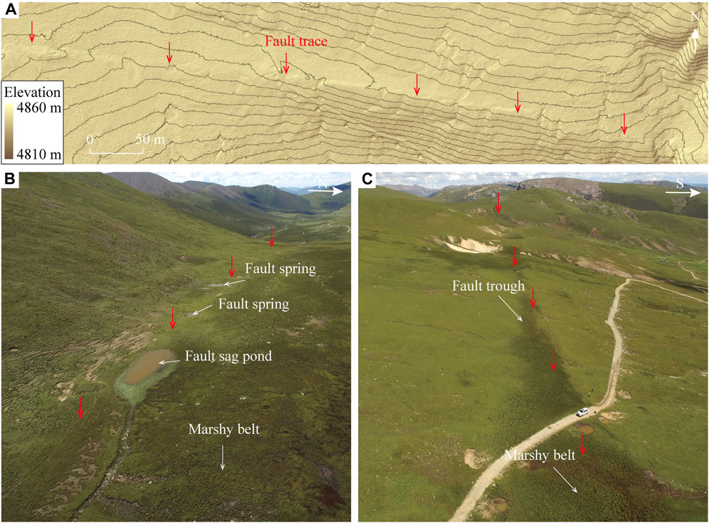
FIGURE 9. Geological and geomorphological features of the Abuduo fault 2 km to the northwest of Xiarike: (A) high-precision topographic and geomorphologic map and fault trace, (B) a series of fault springs and a fault sag pond, and (C) a fault trough and a marshy belt.
The Abuduo fault in the Quechada area is obviously linear, and extends diagonally to the northeast from the hillside, cutting across the ridge. The linear trace is obvious, and gully displacements can be seen along the line of the fault. Western and eastern gullies with left-lateral displacement of 12.2 and 14.5 m, respectively, were initially identified (Figure 10).
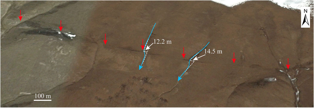
FIGURE 10. Fault trace of the Abuduo fault in the Quechada area. The image was obtained from Google Earth.
A surface rupture zone with length of at least 1.2 km and a series of gully displacement were discovered approximately 0.6 km to the north of Achapo. The topography and geomorphology of this area were mapped using the small UAV and Agisoft PhotoScan software (Figures 11A, B), which revealed the obvious linear trace of the fault. In the Achapo area, the Abuduo fault cuts across ridges, slopes, and gullies, creating typical surface rupture zones, together with tectonic–geologic landforms such as fault troughs, reverse troughs, and gully displacement (Figures 11C, D). All the gullies in the region that have been cut by the fault show obvious left-lateral features. The displacement of a typical small-scale gully was measured, and the magnitude of left-lateral displacement of the gully was 10.9 m (Figure 11B). The obvious seismic surface rupture and series of alluvial left-lateral displacement at the site indicate the most recent activity of the Abuduo fault, and the geomorphological features of the site strongly suggest that the Abuduo fault is a left-lateral strike-slip fault with Holocene activity.
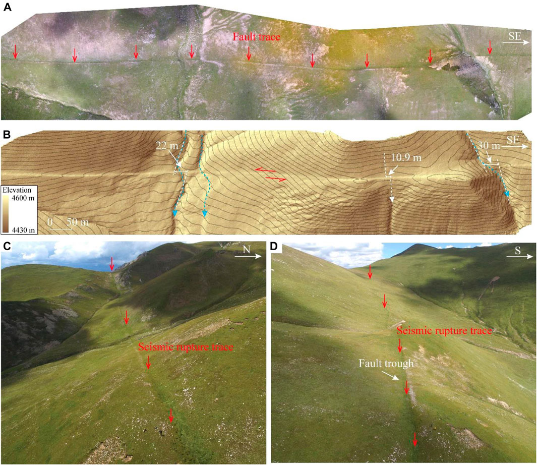
FIGURE 11. Geological and geomorphological features of the Abuduo fault 0.6 km to the north of Achapo: (A) high-precision orthophoto, (B) high-precision topographical and geomorphological map showing gully displacement of 10.9 m, (C) seismic rupture trace, and (D) seismic rupture trace and fault trough.
On the hillside approximately 1.4 km to the southeast of Shanikuo, a seismic surface rupture with an obvious linear trace and gully displacements were found. The topography and geomorphology of the area were mapped using the UAV and Agisoft PhotoScan software. The surface rupture trace of the fault at this location was clearly visible, crossing the ridge to the west and forming a fault trough landform (Figure 12A). The fault at this location cuts across the hillside, forming an obvious linear trace on the hillside (Figure 12B) and producing a gully displacement landform (Figure 12C). The left-lateral strike-slip displacement of the gully, measured against the gully wall, was found to be 5.8 m. Geomorphologic evidence at this site similarly suggests that the Abuduo fault is a left-lateral strike-slip fault with Holocene activity.
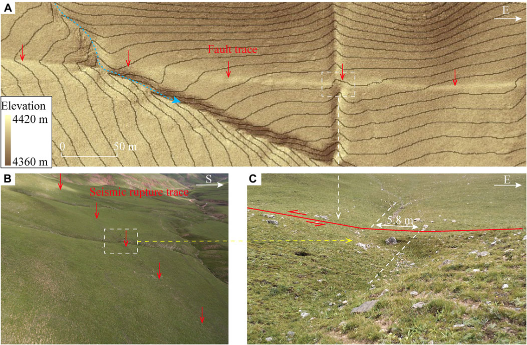
FIGURE 12. Geological and geomorphological features of the Abuduo fault 1.4 km to the southeast of Shanikuo: (A) high-precision topographic and geomorphologic map and fault trace, (B) seismic rupture trace, and (C) thea gully with displacement of 5.8 m.
The Abuduo fault is a near E–W-trending strike-slip fault on the southern side of the Garzê–Yushu fault on the eastern margin of the Tibetan Plateau. Along the fault, a river terrace (T2) was found to exhibit left-lateral displacement of 3.9 m at the Zhanakou geomorphological site. A series of gullies presented left-lateral displacement by the Abuduo fault at the Achapo geomorphological site, and the magnitude of the displacement of the smaller gully was 10.9 m, A series of gullies was also found to show left-lateral displacement at the Shanikuo geomorphological site, and the magnitude of the displacement of one of the smaller gullies was 5.8 m. There was no obvious fault scarp along the fault, which was formed by the normal or reverse faults, and the above geomorphological evidence indicates that the deformation associated with the Abuduo fault exhibits predominantly left-lateral strike-slip characteristics. The Abuduo fault cuts through pre-mountain alluvial fans, secondary terraces of rivers (T2), and small alluvial gullies, and the trace of the fault is reasonably clear with obvious seismic surface rupture zones, especially at the Xiarike, Achapo, and Shanikuo geomorphological investigation sites. According to remote sensing image interpretation and analysis of field seismic and geologic data, the Abuduo fault is represented by a 65-km seismic surface rupture zone that extends westward from Abuduo to Selikou Village. The relevant seismic and geologic features indicate that the Abuduo fault has Holocene activity, with potential for strong earthquakes; therefore, the associated earthquake risk requires further attention. The magnitude of the most recent strong earthquake on the Abuduo fault, calculated using the formulas (Formula 1) suggested by Wells and Coppersmith (1994), was approximately Mw7¼:
where SRL indicates the surface rupture length [km] and M indicates the moment magnitude.
If the 5.8 m gully displacement of the Shanikuo geomorphological site is considered as the maximum displacement of the most recent strong earthquake, the magnitude of the most recent strong earthquake on the Abuduo fault, calculated using the formulas (Formula 2) suggested by Wells and Coppersmith (1994), was approximately Mw7¼:
where MD indicates the maximum displacement [m] and M indicates the moment magnitude.
Together, we estimate the magnitude of the most recent strong earthquake on the Abuduo fault to be approximately Mw7¼.
Relevant studies have shown that the slip rate of the Batang fault since the Late Quaternary has been 2.21–3.7 mm/a (Huang et al., 2015;Wang et al., 2015; You et al., 2016), and some studies have suggested that the Batang fault has decomposed the strike-slip deformation of the Garzê–Yushu fault, which has led to change in the slip rate of the Garzê–Yushu fault (Huang et al., 2015; Lv et al., 2017). In addition, related studies also believe that the Maisu fault likely accommodates the partitioned horizontal slip deformation of the Garzê–Yushu fault (Zuo et al., 2022). The Abuduo fault is a left-lateral strike-slip fault with Holocene activity, and its tendency is similar to that of the Batang fault and Maisu fault, i.e., both have near E–W alignment, and the eastward extension of the Abuduo fault is likely to intersect the Garzê–Yushu fault. Therefore, the Abuduo fault is also likely to have decomposed the strike-slip deformation of the Garzê–Yushu fault, but further studies on its slip rate are needed.
The Abuduo fault is a left-lateral strike-slip fault with Holocene activity on the southern side of the Garzê–Yushu fault, and it has total length of approximately 110 km. The Abuduo fault retains a reasonably intact seismic surface rupture zone, and a 65-km seismic surface rupture zone has been identified along the rupture. On the basis of the length of the rupture zone and relevant calculation formulas, it is believed that the magnitude of the most recent major earthquake on the fault was approximately Mw7¼. The field seismological–geological data indicate that the fault has tectonic conditions suitable for breeding and generating strong earthquakes.
The original contributions presented in the study are included in the article/supplementary material, further inquiries can be directed to the corresponding authors.
CL: Data curation, Investigation, Visualization, Writing–original draft. ML: Conceptualization, Funding acquisition, Writing–review and editing. HC: Data curation, Investigation, Writing–review and editing. ZM: Conceptualization, Data curation, Investigation, Writing–review and editing. WW: Data curation, Writing–review and editing. YG: Data curation, Writing–review and editing. HZ: Data curation, Writing–review and editing. SL: Software, Writing–review and editing. TL: Data curation, Writing–review and editing. ZL: Data curation, Writing–review and editing.
The author(s) declare financial support was received for the research, authorship, and/or publication of this article. The earthquake catalog used in this study was provided by the Sichuan Earthquake Agency, Chengdu, China. This work was financially supported by the Lhasa National Geophysical Observation and Research Station (NORSLS21-04), Special Fund of the Institute of Earthquake Forecasting, China Earthquake Administration (CEAIEF2022050502), The research team of earthquake sequence tracing and post-earthquake trend, China Earthquake Administration, and National Key Research and Development Program of China (2021YFC3000601).
Author ZM was employed by Yonglilink Science & Technology Company Limited. Author ZL was employed by Sichuan Institute of Geological Enfineering Inveestigation Group Company Limited.
The remaining authors declare that the research was conducted in the absence of any commercial or financial relationships that could be construed as a potential conflict of interest.
All claims expressed in this article are solely those of the authors and do not necessarily represent those of their affiliated organizations, or those of the publisher, the editors and the reviewers. Any product that may be evaluated in this article, or claim that may be made by its manufacturer, is not guaranteed or endorsed by the publisher.
Ai, M., Bi, H. Y., Zheng, W. J., Ying, J. H., Yuan, D. Y., Ren, Z. K., et al. (2018). Using Unmanned Aerial Vehicle photogrammetry technology to obtain quantitative parameters of active tectonics. Seismol. Geol. 40 (6), 1 276–281 293. doi:10.3969/j.issn.0253-4967.2018.06.006
Chen, G. H., Xu, X. L., Wen, X. Z., and Wang, Y. L. (2008). Kinematic transformation, deformation and decomposition of active tectonic belt in the northern-eastern boundary of the Sichuan-Yunnan block. Seismol. Geol. 30 (01), 58–85.
Deng, Q. D., Cheng, S. P., Ma, J., and Du, P. (2014). Seismic activities and earthquake potential in the Tibetan Plateau. Chin. J. Geophys. 57 (7), 2025–2042. doi:10.3969/j.issn.0253-4967.2014.03.002
Deng, Q. D., Zhang, P. Z., Ran, Y. K., Yang, X. P., Ming, W., and Chu, Q. Z. (2002). Basic characteristics of active structure in China. Sci. China earth Sci. 12 (32),1020–1030.
Huang, X. M., Du, Y., He, Z. T., Ma, B. Q., and Xie, F. R. (2015). Late Quaternary slip rate of the Batang Fault and its strain partitioning role in Yushu area, central Tibet. Acta Sci. Nat. Univ. pekin. 51 (1), 52–67. doi:10.1016/j.tecto.2015.03.026
Li, J. C., Wu, Z. H., Zhang, D., and Liu, X. D. (2023). Remote sensing image interpretation and tectonic activity study of the main active faults in Yushu area, Qinghai Province. Geol. Bull. China 33 (04), 535–550.
Li, M. F., Xing, C. Q., Cai, C. X., Guo, W. X., Wu, S. X., Yuan, Z. Z., et al. (1995). Research on activity of Yushu fault. Seismol. Geol. 17 (03), 218–224.
Li, X., Yuan, Z. D., He, K. F., Liu, X. L., Liu, Z. M., et al. (2021). Evaluating the potentiality of using control-free images from a mini Unmanned Aerial Vehicle(UAV) and Structure-from-Motion (SfM) photogrammetry to measure paleoseismic offsets. J. Geophys. Res. Solid Earth 42 (7), 2417–2439. doi:10.1080/01431161.2020.1862434
Li, Y. B., Wang, H., Liu, H. G., and Chen, L. C. (2016). The surface rupture remains along the Dangjiang segment of Garzê-Yushu fault and the 1738 AD earthquake. Technol. Earthq. disaster Prev. 11 (02), 207–217. doi:10.11899/zzfy20160204
Liang, M. J., Dong, Y., Liao, C., Qin, Y. L., Zhang, H. P., Wu, W. W., et al. (2023). Holocene activity of the Wudaoliang–Changshagongma fault of the eastern Tibetan plateau. Remote Sens. 15 (2458), 2458–2513. doi:10.3390/rs15092458
Liang, M. J., Huang, F. P., Sun, K., Zhang, H. P., Wu, W. W., Zhang, J. W., et al. (2022). The holocene activity and its evidence from paleoearthquake of the middle segment of Wudaoliang-Changshagongma fault inside the Bayan Har block. Earth Sci. 47 (03), 766–778. doi:10.3799/dqkx.2022.044
Lin, A. M., Rao, G., Jia, D., Wu, X. J., Yan, B., and Ren, Z. K. (2011). Co-seismic strike-slip surface rupture and displacement produced by the 2010 Mw6.9 Yushu earthquake, China, and implications for Tibetan tectonics. J. Geodyn. 52 (3-4), 249–259. doi:10.1016/j.jog.2011.01.001
Lv, L. X., Li, C. Y., Wei, Z. Y., Dong, J. Y., Tan, X. B., Shi, F., et al. (2017). Late quaternary strike-slip rate and slip partitioning along Garzê-Yushu fault belt. Technol. Earthq. disaster Prev. 12 (03), 456–468. doi:10.11899/zzfy20170302
Peng, H., Ma, M. X., Bai, J. Q., and Du, D. P. (2006). Characteristics of quaternary activities of the Garzê-Yushu fault zone. J. geomechanics 12 (03), 295–304.
Qiao, X. J., Wang, Q., and Du, R. L. (2004). The active block in the Sichuan-Yunnan area reflects the deformation characteristics of the earth's crust. Chin. J. Geophys 47 (05), 805–811.
Shi, F., He, H. L., Densmore, A. L., Yang, X. P., and Xu, X. W. (2016). Active tectonics of the Ganzi-Yushu fault in the southeastern Tibetan Plateau. Tectonophysics 676, 112–124. doi:10.1016/j.tecto.2016.03.036
Wang, T. W., You, J. F., Yan, B. L., Jia, Z. L., Zhang, W., Ma, C., et al. (2015). Study of late quaternary activity of Yushu Batang fault in Qinghai. J. Inst. disaster Prev. 17 (04), 9–17.
Wells, D., and Coppersmith, K. (1994). New empirical relationships among magnitude, rupture length, rupture width, rupture area, and surface displacement. Bull. Seismol. Soc. Am. 84 (4), 974–1002. doi:10.1785/bssa0840040974
Wen, X. Z., Ma, S. L., Xu, X. W., and He, Y. N. (2008). Historical pattern and behavior of earthquake ruptures along the eastern boundary of the Sichuan-Yunnan faulted-block, southwestern China. Phys. earth Planet. interiors 168, 16–36. doi:10.1016/j.pepi.2008.04.013
Wen, X. Z., Xu, X. W., Zheng, R. Z., Xie, Y. Q., and Wan, C. (2003). The average sliding rate and recent strong earthquake rupture of the Garzê-Yushu fault. Sci. China earth Sci. 33 (S1), 199–208.
Wu, Z. H., Zhou, C. J., Fang, H., Zhang, K. Q., Li, J. C., Ye, P. S., et al. (2014). Active faults and earthquake around Yushu in eastern Tibetan Plateau. Geol. Bull. China 33 (4), 419–469.
Xu, X. W., Wen, X. Z., Zheng, R. Z., Ma, W. T., Song, F. M., and Yu, G. H. (2003). The latest tectonic change pattern and power source of active blocks in the Sichuan-Yunnan region. Sci. China earth Sci. 33 (S1), 151–162.
You, J. F., Li, Y., and Wang, T. W. (2016). A study on the activity of Batang fault since quaternary in yushu area. Geol. Yunnan 35 (02), 137–142.
Zhang, P. Z., Wang, Q., and M, Z. Q. (2002). Gps velocity field and active crustal blocks of contemporary tectonic deformation in continental China. Earth Sci. Front. 9 (2), 430–438.
Zhou, R. J., Ma, H. S., and Cai, Z. (1996). Late quaternary active features of the Garzê-Yushu fault zone. Earthq. Res. China 12 (03), 250–260.
Zhou, R. J., Wen, X. Z., Cai, C. X., and Ma, S. H. (1997). Recent earthquakes and assessment of seismic tendency on the Garzê-Yushu fault zone. Seismol. Geol. 1 (02), 20–29.
Zhu, L. D., Wang, C. H., Yi, H. S., Liu, D. Z., Xiang, F., Liu, Z. F., et al. (2004). Basin systen evolution and formation time of Qinghai-Tibet Plateau. J. chengdu Univ. Technol. &technology Ed. 31 (03), 249–255.
Zielke, O., Arrowsmith, J. R., Grant, L. L., and Akçiz, S. O. (2010). Slip in the 1857 and earlier large earthquakes along the carrizo plain, san andreas fault. Science 327 (5 969), 1119–1122. doi:10.1126/science.1182781
Keywords: Abuduo fault, Garzê–Yushu fault, Holocene activity, surface rupture, Tibetan plateau
Citation: Liao C, Liang M, Chen H, Mao Z, Wu W, Gong Y, Zuo H, Liu S, Li T and Li Z (2024) Holocene activity and seismic surface rupture zone of the Abuduo fault eastern Tibetan Plateau. Front. Earth Sci. 12:1351970. doi: 10.3389/feart.2024.1351970
Received: 07 December 2023; Accepted: 08 January 2024;
Published: 25 January 2024.
Edited by:
Hu Wang, Southwest Jiaotong University, ChinaCopyright © 2024 Liao, Liang, Chen, Mao, Wu, Gong, Zuo, Liu, Li and Li. This is an open-access article distributed under the terms of the Creative Commons Attribution License (CC BY). The use, distribution or reproduction in other forums is permitted, provided the original author(s) and the copyright owner(s) are credited and that the original publication in this journal is cited, in accordance with accepted academic practice. No use, distribution or reproduction is permitted which does not comply with these terms.
*Correspondence: Mingjian Liang, bGlhbmdtaW5namlhbkBzY2R6ai5nb3YuY24=; Zebin Mao, bWFvemViaW5AMTI2LmNvbQ==
Disclaimer: All claims expressed in this article are solely those of the authors and do not necessarily represent those of their affiliated organizations, or those of the publisher, the editors and the reviewers. Any product that may be evaluated in this article or claim that may be made by its manufacturer is not guaranteed or endorsed by the publisher.
Research integrity at Frontiers
Learn more about the work of our research integrity team to safeguard the quality of each article we publish.