95% of researchers rate our articles as excellent or good
Learn more about the work of our research integrity team to safeguard the quality of each article we publish.
Find out more
CORRECTION article
Front. Earth Sci. , 01 September 2023
Sec. Solid Earth Geophysics
Volume 11 - 2023 | https://doi.org/10.3389/feart.2023.1258767
This article is a correction to:
The February 2018 seismic swarm in São Miguel, Azores
A Corrigendum on
The february 2018 seismic swarm in São Miguel, Azores
by Soares A, Custódio S, Cesca S, Silva R, Vuan A and Mendes VB (2023). Front. Earth Sci. 11:1144151. doi: 10.3389/feart.2023.1144151
In the published article, there was an error in the text of the Abstract. The sentence in question previously stated:
“After ∼1 week, a new earthquake family emerged at shallower depths (∼8–12 km) reaching magnitudes up to ML 3.7”.
The corrected sentence appears below:
“After ∼1 week, a new earthquake family emerged at shallower depths (∼8–12 km) reaching magnitudes up to ML 3.4”.
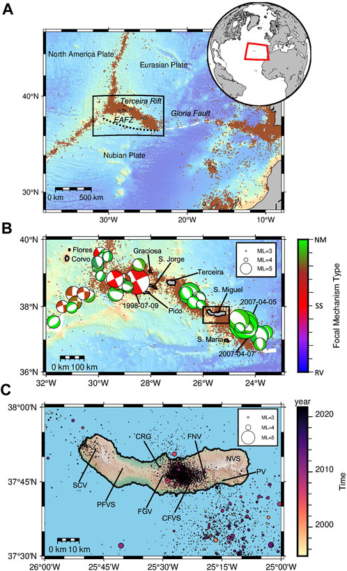
Additionally, there was an error in (Figure 1) as published. The colorbar legend of Figure 1B was ranged from 0.0 to 1.0 when it should have specified the types of focal mechanism: Reverse (RV), Strike-Slip (SS) and Normal (NM) ordered from bottom to top.

FIGURE 1. (A) Location of the Azores Archipelago, in the triple junction between the North American, Eurasian and Nubian plates. Earthquake locations are shown according to the ISC catalog from 1995 to 2021 (brown dots). The currently inactive East Azores Fracture Zone (EAFZ) is shown by a dotted line and the rectangle identifies the Azores archipelago region, shown in (B). (B) Earthquake epicenters (brown dots) and focal mechanism, sized by magnitude, indicating a dominantly transtensional regime from the Global CMT catalog (Ekström et al., 2012). Colors indicate the type of faulting, from reverse (blue) through strike-slip (red) to normal (green), according to the Kaverina classification (Kaverina et al., 1996), as implemented in FMC (Álvarez-Gómez, 2019). The three events with magnitude Mw > 6 mentioned in the text are identified by their dates. The rectangle identifies the S. Miguel region, shown in (C). (C) Earthquake epicenters in S. Miguel colored according to time of occurrence, circle size indicates magnitude. S. Miguel Digital Elevation Model (DEM) was generated from a 1:5,000 scale digital altimetric database from the Secretaria Regional do Turismo e Transportes of the Azores Government. It is also shown the locations of the volcano-tectonic features identified in Carmo et al. (2015): (SCV) Sete Cidades Volcano; (PFVS) Picos Fissural Volcanic System; (FGV) Fogo Volcano; (CFVS) Congro Fissural Volcanic System; (FNV) Furnas Volcano; (PV) Povoação Volcano; (NVS) Nordeste Volcanic System.
The corrected (Figure 1) and its caption “(A) Location of the Azores Archipelago, in the triple junction between the North American, Eurasian and Nubian plates. Earthquake locations are shown according to the ISC catalog from 1995 to 2021 (brown dots). The currently inactive East Azores Fracture Zone (EAFZ) is shown by a dotted line and the rectangle identifies the Azores archipelago region, shown in (B). (B) Earthquake epicenters (brown dots) and focal mechanism, sized by magnitude, indicating a dominantly transtensional regime from the Global CMT catalog (Ekström et al., 2012). Colors indicate the type of faulting, from reverse (blue) through strike-slip (red) to normal (green), according to the Kaverina classification (Kaverina et al., 1996), as implemented in FMC (Álvarez-Gómez, 2019). The three events with magnitude Mw > 6 mentioned in the text are identified by their dates. The rectangle identifies the S. Miguel region, shown in (C). (C) Earthquake epicenters in S. Miguel colored according to time of occurrence, circle size indicates magnitude. S. Miguel Digital Elevation Model (DEM) was generated from a 1:5000 scale digital altimetric database from the Secretaria Regional do Turismo e Transportes of the Azores Government. It is also shown the locations of the volcano-tectonic features identified in Carmo et al. (2015): (SCV) Sete Cidades Volcano; (PFVS) Picos Fissural Volcanic System; (FGV) Fogo Volcano; (CFVS) Congro Fissural Volcanic System; (FNV) Furnas Volcano; (PV) Povoação Volcano; (NVS) Nordeste Volcanic System”. appear below.
The authors apologize for these errors and state that this does not change the scientific conclusions of the article in any way. The original article has been updated.
All claims expressed in this article are solely those of the authors and do not necessarily represent those of their affiliated organizations, or those of the publisher, the editors and the reviewers. Any product that may be evaluated in this article, or claim that may be made by its manufacturer, is not guaranteed or endorsed by the publisher.
Keywords: spatio-temporal earthquake evolution, earthquake detection-location, waveform analysis, seismic swarm, São Miguel island, Azores triple junction
Citation: Soares A, Custódio S, Cesca S, Silva R, Vuan A and Mendes VB (2023) Corrigendum: The february 2018 seismic swarm in São Miguel, Azores. Front. Earth Sci. 11:1258767. doi: 10.3389/feart.2023.1258767
Received: 14 July 2023; Accepted: 07 August 2023;
Published: 01 September 2023.
Edited and reviewed by:
Giovanni Martinelli, National Institute of Geophysics and Volcanology, ItalyCopyright © 2023 Soares, Custódio, Cesca, Silva, Vuan and Mendes. This is an open-access article distributed under the terms of the Creative Commons Attribution License (CC BY). The use, distribution or reproduction in other forums is permitted, provided the original author(s) and the copyright owner(s) are credited and that the original publication in this journal is cited, in accordance with accepted academic practice. No use, distribution or reproduction is permitted which does not comply with these terms.
*Correspondence: A. Soares, YW5hbGR5bmUuc29hcmVzQGNhbXB1cy51bC5wdA==
Disclaimer: All claims expressed in this article are solely those of the authors and do not necessarily represent those of their affiliated organizations, or those of the publisher, the editors and the reviewers. Any product that may be evaluated in this article or claim that may be made by its manufacturer is not guaranteed or endorsed by the publisher.
Research integrity at Frontiers

Learn more about the work of our research integrity team to safeguard the quality of each article we publish.