 Mingjian Wang
 Long Huang1*
94% of researchers rate our articles as excellent or good
Learn more about the work of our research integrity team to safeguard the quality of each article we publish.
Find out more
ORIGINAL RESEARCH article
Front. Earth Sci., 09 May 2023
Sec. Structural Geology and Tectonics
Volume 11 - 2023 | https://doi.org/10.3389/feart.2023.1176929
This article is part of the Research TopicQuantitative Characterization and Engineering Application of Pores and Fractures of Different Scales in Unconventional Reservoirs, volume IIIView all 15 articles
The South Yellow Sea Basin (SYSB) is an extension of the Lower Yangtze Block to the sea. The basin has undergone a complex tectonic-sedimentary evolution, and there has been no breakthrough in oil and gas exploration. Based on newly collected and processed well drilling data, cores, and seismic data of the central-southern SYSB and adjacent areas, the understudy area is set in the Lower Yangtze Region (LYR) to compare the overall sequence division and sedimentary facies. The Permian isochronous stratigraphic framework is methodically established in the central-southern SYSB, and the corresponding sedimentary facies and their distribution are examined in some detail. Finally, together with the previous investigations of tectonic evolution, the potential Permian oil-gas accumulation modes are proposed. The achieved results reveal that the second-order Permian sequence developed in the central-southern SYSB is consistent with the LYR. There exists a relatively complete second-order sequence I developed in the middle-bottom section and the transgressive systems tract of sequence II in the upper section. The Permian sedimentary system in the central-southern SYSB can be compared to the LYR and is generally distributed in a northeast direction. The transgressive systems tract of sequence I is broadly developed with the restricted platform and open platform as the dominant facies. The highstand systems tract of sequence I has been only developed in the northwest of the understudy area, with the shelf as the dominant facies. The transgressive systems tract of sequence II is mostly dominated by delta facies and swamp-lagoon facies with thick coal-measure layers, which provide a material basis for the formation of large-scale oil and gas fields. The thermal evolution of Permian source rocks was controlled by a combination of tectonic evolution and paleothermal gradient. Permian source rocks may have experienced secondary hydrocarbon generation in the western part of the southern Depression, whereas source rocks elsewhere experience only one hydrocarbon generation in the Early Triassic. The obtained results reveal that there are significant differences in the accumulation mode of different structural units.
The South Yellow Sea Basin (SYSB) is a marine extension of the Lower Yangtze Plate and is a polycyclic superimposed basin that developed in the pre-Sinian metamorphic basement. Before the Indosinian movement, the LYR as a whole was a unified marine-dominated sedimentary basin, and the stratigraphic development of the Subei Basin in the onshore area was obviously consistent with that of the SYSB in the offshore area. After the Indosinian movement, the unified marine sedimentary basin in the LYR broke up and entered the stage of continental basin with differentiated tectonic-sedimentary evolution. The results of the present research reveal that the Mesozoic and Paleozoic marine strata in the SYSB are highly developed and the structural deformation is comparatively weak, which is a relatively stable block. Currently, a large number of oil and gas shows have been found in the Lower Triassic Qinglong Formation and Upper Carboniferous Chuanshan Formation in the Subei Basin. The regeneration gas fields originating from the Mesozoic and Paleozoic have been also detected in Zhujiadun, Yancheng City. The oil-seedlings were observed in the limestone fractures of the Lower Triassic Qinglong Formation in the CSDP-2 well in the central Uplift of the SYSB. A large amount of asphalt has been seen in the fractures of the Silurian sandstone. These exploration results indicate that there are generation-migration-accumulation processes of oil and gas in the Mesozoic and Paleozoic of the LYR, which has a good prospect for oil and gas exploration.
Many scholars have carried out research on the petroleum geological conditions of the SYSB, and have achieved rich research results. The latest research results mainly include the following aspects. Wang et al. (2014) carried out a systematic analysis of the Permian hydrocarbon accumulation conditions by using the drilling data and 2D seismic data of the southern depression of the SYSB. Based on the drilling and core data of CSDP-02 holes implemented on the central Uplift of the SYSB, Cai et al. (2018a), Cai et al. (2018b), Cai et al. (2021a) and Cai et al. (2021b) carried out a study on the upper Paleozoic sedimentary environment of the central Uplift, and the hydrocarbon generation stages of the Meso-Paleozoic source rocks are also discussed. Lei (2018) and Lei (2022) used 2D seismic data of the SYSB to carry out the study of structural deformation in the study area since the Indosinian period, analyzed the deformation mechanism, and discussed the exploration prospects of oil and gas resources on the central Uplift. Although SYSB has experienced many years of exploration, there are still no significant oil and gas discoveries so far. It is the only offshore sedimentary basin in China that has not achieved oil and gas breakthroughs. Based on preceding research results, the following major problems exist. The Mesozoic and Paleozoic marine strata in the SYSB are deeply buried, the physical property differences in carbonate strata are almost trivial, the quality of seismic reflection imaging is poor, and the common seismic reflection interface is difficult to laterally trace. The study area has experienced the superimposed transformation of multi-stage tectonic movements and has complex structural features that lead to the existence of multiple seismic interpretation schemes (Zhu et al., 2002; Yang et al., 2003; Yang and Chen, 2003; Ma, 2007; Lei, 2018; Liang, 2021; Lei, 2022; Wang, 2022). There is little deep drilling data in this area and the seismic profile network is sparse and of poor quality (Ye, 2006; Wang, 2014; Wang, 2016; Wang, 2018; Wang, 2020). There is a lack of systematic understanding of the development of Permian sedimentary facies and the distribution of favorable source rocks (Wang, 2005; Wang, 2014; Qiu, 2018; Wang, 2018; Wang, 2020; Mi, 2022). The SYSB has not been generally investigated in the entire LYR, and a lack of comparative study on sequence division and sedimentary system development with other regions in the LYR is obvious (Ye, 2006; Hu, 2010; Cai, 2018a; Cai, 2021a). Different tectonic units in this region have different tectonic evolution histories, and the histories of hydrocarbon generation of the source rocks are also remarkably different (Wang, 2018; Chen, 2020). Up till now, hydrocarbon accumulation processes and modes of diverse tectonic units have not been systematically discussed (Dai, 2005; Wang, 2014; Wang, 2018; Zhang, 2018; Zhang, 2021; Li, 2022). These factors lead to the lack of oil and gas exploration goals, which limits the processes of oil and gas explorations in the study area. Among the many factors affecting oil and gas accumulation, sedimentation controls the development law of source rocks and reservoirs, which is the first basic problem to be solved (Radwan, 2021; Marghani, 2022).
From the point of view of the tectonic location, the SYSB is located in the eastern part of the LYR, in the east of the Tancheng-Lujiang fault, in the south of the Sujiao orogenic belt, in the north of the Jiangshan-Shaoxing fault belt and Zhemin Uplift. It is adjacent to the Korean Peninsula in the east and consists of five tectonic units from north to south, which are: Qianliyan Uplift, northern Depression, central Uplift, southern Depression, and Wunansha Uplift (Figure 1). The study area covers the central-southern part of the SYSB, including part of the central Uplift, the Southern Depression, and a portion of the Wunansha Uplift. The SYSB has experienced a drastic transformation with the evolution of the Indosinian Movement, the Yanshan Movement, and the Himalayan Movement; hence, it exhibits complex structural features. Drilling data confirms that platform deposits are extensively developed in the SYSB from the Paleozoic to the Triassic (Wang, 2014; Wang, 2016; Cai, 2018b; Wang, 2018; Wang, 2020; Cai, 2021a; Cai, 2021b; Wang, 2022; Wang, 2023), and their lithology and seismic geological sequence in the SYSB are consistent with these on the land, which is a series of strata dominated by marine carbonate rocks (Figure 2). From bottom to top, the strata in order are Sinian, Cambrian, Ordovician, Lower Middle Silurian, Upper Devonian, Carboniferous, Permian, Lower Triassic, Upper Cretaceous, Paleogene, and Neogene-Quaternary. Among them, Upper Cretaceous and Paleogene are moderately limited in distribution and mainly occur in the depression, whereas in other areas, the Neogene directly overlies the Upper Paleozoic or Lower Triassic (Table 1).
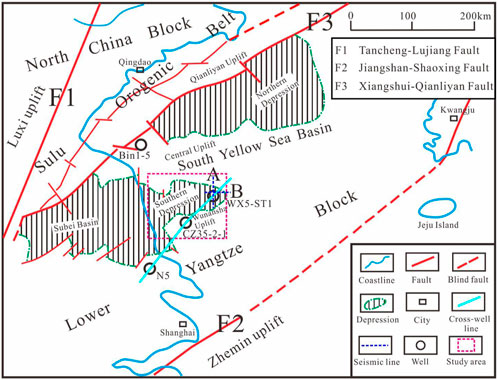
FIGURE 1. Tectonic location of the study area. The current tectonic relationship between SYSB and adjacent area is shown in this figure.
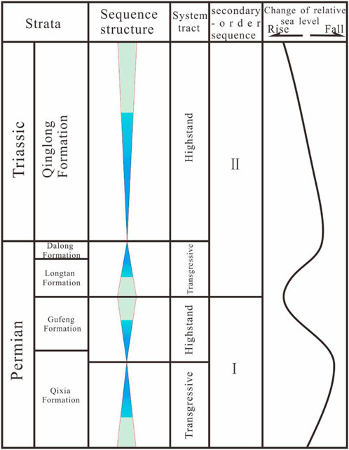
FIGURE 2. Division of the second-order sequence in the Permian system, LYR. Stratigraphic framework of Permian is shown in this figure (modified from Ma et al., 2009; Cai et al., 2018b; Cai, 2021a).
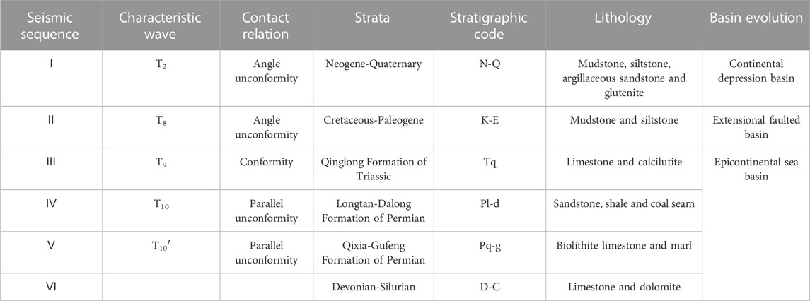
TABLE 1. Seismic sequence and strata property since Devonian in the central-southern part of the SYSB.
Referring to the previous research results of the LYR, three regional unconformities could be identified in the target layers of the study area. Among them, the unconformity between the Qixia Formation and the Carboniferous was configured by the Suwan tectonic movement, the regional unconformity between the Gufeng Formation and the Longtan Formation was formed by the Dongwu movement, and a regional angular unconformity was created on top of the Qinglong Formation by the Indosinian movement. The Permian-Triassic can be divided into two second-order sequences, namely, sequence I including the Qixia Formation and Gufeng Formation, and sequence II including the Longtan Formation, Dalong Formation, and Qinglong Formation (Figure 2). Sequences I and II developed only transgressive and highstand systems tract, and lacked lowstand systems tract (Figure 2). The object of this investigation is the Permian, which contains a well-developed sequence I and the transgressive systems tract of sequence II.
A total of 6 wells which drilled the Permian were collected in the study area and adjacent areas, and the sequence development features of wells WX5-ST1 and Bin 1–5 with relatively complete stratigraphic development are presented below.
The well Bin 1–5 is located on the west side of the central Uplift and was drilled deep into the Qixia Formation, and the overlying Gufeng Formation is directly overlain by the Neogene. Due to the effect of multi-stage tectonic movements, only sequence I is preserved in this well, and sequence II is denuded. Sequence I only develops the transgressive systems tract and highstand systems tract, and thereby, the lowstand systems tract is not developed.
The transgressive systems tract of sequence I in the Bin 1–5 well includes the middle and lower parts of the Qixia Formation. Lithologically, it is mostly composed of limestone and mudstone, containing calcified brachiopod fragments, less coral, encrinite fossils and common pyrite. This set of rocks is formed in relatively shallow water with a weak hydrodynamic environment, where the restricted platform facies is developed.
The highstand systems tract of sequence I in Bin 1–5 well includes the upper parts of the Qixia and Gufeng Formations, and the top of the sequence is a weathered denudation surface (Figure 3). The lithology is mainly gray-black mudstone, sandy mudstone, fine sandstone, and siltstone rich in carbon debris and ammonite fossils in local areas. Horizontal beds are broadly developed, followed by wavy beds. This formation is formed in a relatively weak hydrodynamic environment that can be affected by waves. This systems tract leads to the development of the lagoon facies in a coastal environment.
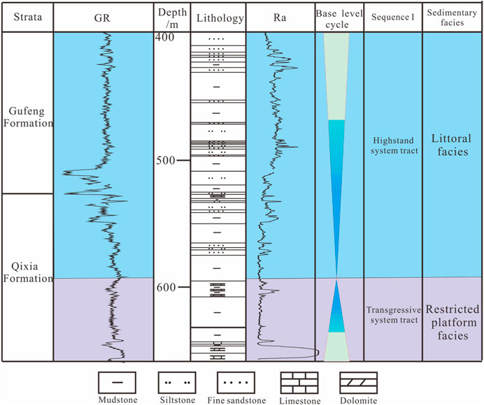
FIGURE 3. Division of sequence and sedimentary facies of sequence I in well Bin 1–5.
The WX5-ST1 well is located in the eastern part of the southern Depression of the SYSB and has been drilled in the Permian Longtan Formation. The Longtan Formation to the Qinglong Formation belongs to sequence II (Longtan Formation, Dalong Formation, and Qinglong Formation), and the upper sequence boundary is the top of Qinglong Formation, which represents a regional unconformity surface, and the lower boundary of the sequence cannot be revealed by digging. This sequence develops the transgressive systems tract and the highstand systems tract from the bottom up. The lowstand systems tract is undeveloped, and the highstand systems tract occupies the main body of the sequence, whereas the thickness of the transgressive systems tract (Longtan-Dalong Formation) is moderately thin (Figure 5).
The transgressive systems tract of sequence II in this well comprises the Longtan Formation and the middle-lower part of the Dalong Formation, which can be divided into three parts based on the lithology. The lower part is brown-dark gray siltstone and limestone. The middle part is gray-white-dark gray sandstone, of which the upper part possesses more coal seams. The upper part is dark gray, gray-black siltstone and mudstone, and pyrite is detected in mudstone. This systems tract has mostly incorporated into the development of delta facies and littoral facies.
Based on the stratigraphic division of single well sequence in the study area and nearby areas, drilling wells in the Subei Basin and SYSB are chosen to perform the division and comparison of well-connected sequence stratigraphy. The following research focuses on two southwest-northeast well profiles.
From the southwest-northeast well section of sequence I (Figure 4), it can be seen that the transgressive systems tract and highstand systems tract have been developed in the Lower Yangtze land area, whereas in the Lower Yangtze sea area (central-southern part of the SYSB) only the transgressive systems tract has been developed. From west to east, the transgressive systems tract thickness increases, which are essentially characterized by the alternating development of the restricted platform and the open platform, and the interplatform basin facies (Ma, 2009) is developed at the top. The highstand systems tract gradually thins to the sea area and disappears in the central-southern SYSB. The systems tract essentially developed shelf facies. Along with the regional geological background, during this period, the Dongwu tectonic movement occurred in the LYR with crustal uplift. Seawater gradually retreated from southern China to the south and southwest, and the early sedimentary layers were denuded in most parts of the LYR.
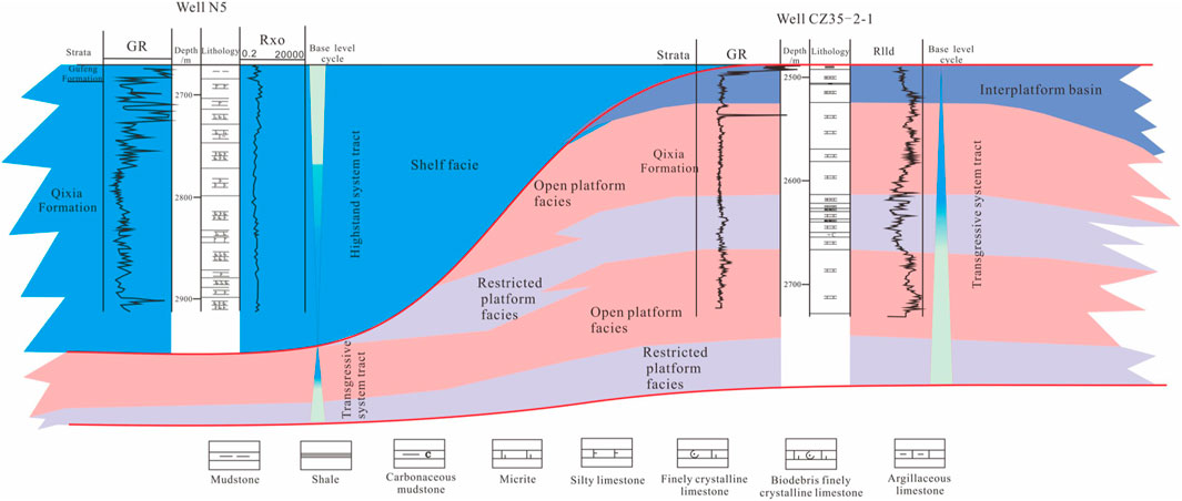
FIGURE 4. Sedimentary facies of sequence I in the cross-well profile (north-east direction). The fill colors represent different sedimentary facies. Stratigraphic framework and sedimentary facies are shown in this figure.
It can be observed from the cross-well profile of sequence II in the southwest-northeast direction (Figure 5) that the top and bottom boundaries of the sequence represent regional unconformity surfaces. After the Dongwu movement, the LYR was generally settled and received sediment. Transgressive and highstand systems tract are developed in both the land and sea areas of the LYR, whereas the lowstand systems tract is not developed. In the early and middle stages, the transgressive systems tract of sequence II incorporated into the development of the swamp-lagoon facies, delta facies, and swamp-lagoon facies from west to east. Further, the deep shelf facies and swamp-lagoon facies from west to east were developed in the late stage. In the initial stage of the highstand systems tract of sequence II, the water deepened and then became shallower from the Lower Yangtze land area to the southern Yellow Sea area. Along this direction, shallow shelf facies, deep shelf facies, shallow shelf facies, and swamp-lagoon facies are sequentially observable. In the middle and final stages, the restricted platform and the open platform were alternately developed. In the final stage of the highstand systems tract, the Yangtze plate and the North China plate collided from east to west, and the LYR generally rose with a decrease in relative sea level. The primary sedimentary strata were exposed to the surface and suffered from severe denudation.
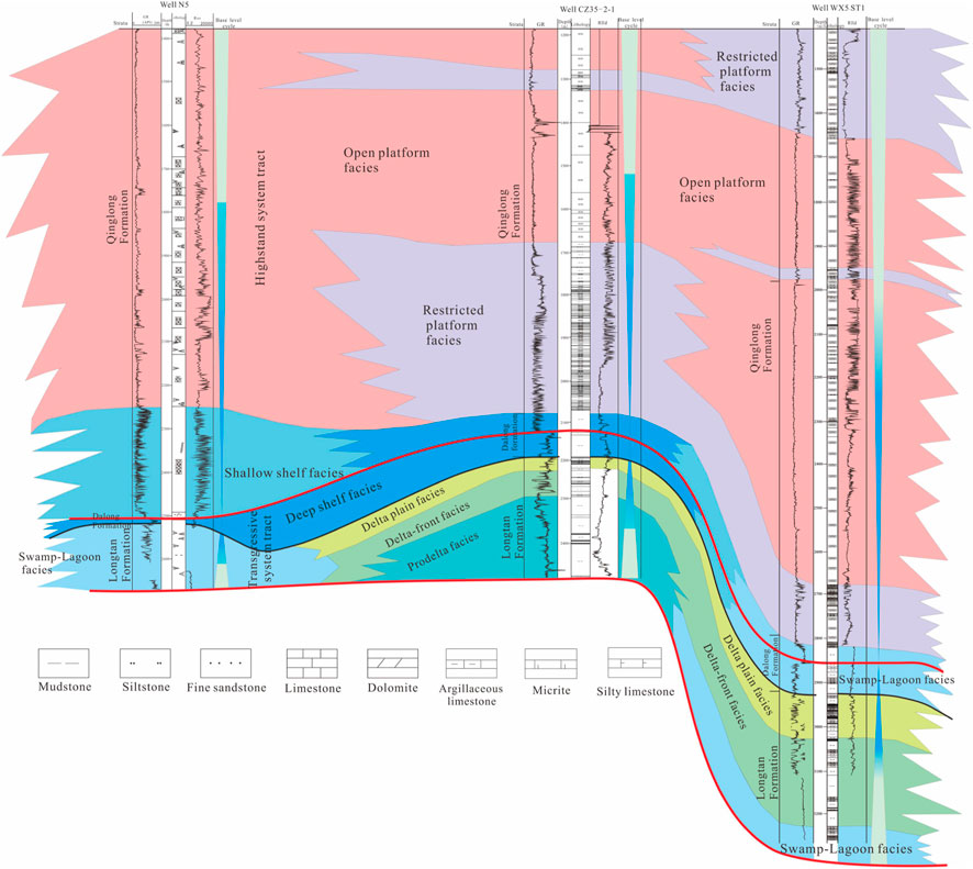
FIGURE 5. Sedimentary facies of sequence II in cross-well profile (north-east direction). The fill colors represent different sedimentary facies. Stratigraphic framework and sedimentary facies are shown in this figure.
Seismic profiles have the advantages of systematic, continuous, and regional distribution that can be employed to track and compare sequence and system boundaries in the basin. Line A is located in the central-eastern SYSB and crosses the Wunansha Uplift, the southern Depression and the central Uplift from south to north. Based on the seismic interpretation, both normal and reverse faults exist. Combined with the regional geological background and seismic interpretation, the reverse faults are essentially configured by the Indosinian movement, whereas the normal faults are mainly formed in the Late Cretaceous-Paleogene. Sequence I only has the transgressive systems tract, which corresponds to the Qixia Formation, and the highstand systems tract may exist in the western part of the study area, but its thickness should be moderately thin (Figure 6). The lithology of this systems tract chiefly exhibits carbonate rock, and the lithology difference between the consisting layers is very small, so it is difficult to form the effective wave impedance, and the characteristics of the wave group are not clear. The transgressive systems tract of sequence II roughly corresponds to the Longtan-Dalong Formation and produces marine clastic rocks. The lithology discrepancy between the constituent layers is large, resulting in strong wave impedance and transparent wave group characteristics. It represents a set of medium-low frequency, medium-strong amplitude, and wave groups with good continuity, and the thickness of the formation is moderately stable.
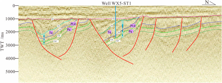
FIGURE 6. Seismic sequence in Line A (north-south direction). The Pq label represents the Qixia Formation of Permian; Pl-d represents the Longtan-Dalong Formation of Permian; Tq represents the Qinglong Formation of Triassic; T2 represents the boundary between the Neogene and Paleogene; T8 represents the top boundary of the Triassic; T9 represents the boundary between the Triassic and Permian; T10 represents the boundary between the Longtan Formation and Qixia Formation; and T10′represents the bottom boundary of Qixia Formation.
Based on the sequence division and sedimentary facies analysis of drilling data in the understudy area as well as the nearby area, combined with the research results of the predecessors, the following seismic facies types are identified on the seismic profile by interpreting the seismic data in the central-southern part of the SYSB.
Seismic facies are sheet-like with a parallel-subparallel reflection structure inside. Seismic reflection is chiefly characterized by weak-moderate-moderate strong amplitude, low frequency, and intermittent-less continuous reflection (Figure 7). Combined with previous research on Permian sedimentary facies in the LYR and seismic data, these seismic wave groups are mainly consistent with shelf facies.
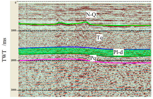
FIGURE 7. Shelf facies in the seismic profile. The Pq label represents the Qixia Formation of Permian; Pl-d represents the Longtan-Dalong Formation of Permian; Tq represents the Qinglong Formation of Triassic; and N-Q represents the Neogene–Quaternary.
Such seismic facies exhibit a progradation structure in the direction of the sediment source (Figure 8) and the seismic reflection demonstrates the characteristics of moderate strong amplitude, low-moderate frequency, and less continuous-continuous reflection. Combined with drilling data, these seismic reflection wave groups commonly represent for delta facies.
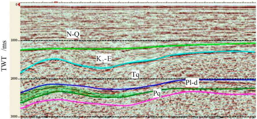
FIGURE 8. Delta facies in the seismic profile (perpendicular to the direction of the sediment source). The Pq label represents the Qixia Formation of Permian; Pl-d represents the Longtan-Dalong Formation of Permian; Tq represents the Qinglong Formation of Triassic; K2-E represents the Late Cretaceous- Paleogene; and N-Q represents the Neogene–Quaternary.
Such seismic facies show that the hydrodynamic force of the sedimentary environment is weak and the wave impedance difference between the layers is relatively high. Together with drilling data and regional sedimentary evolution data, we conclude that such seismic reflection waves are associated with the restricted platform facies.
In combination with the drilling data in the study area, no effective reflection could be established due to the small lithological difference between the thick carbonate layers. These seismic reflection waves in the study area correspond to the facies of the open platform.
During this period, the Lower Yangtze Basin is distributed in the north-east direction restricted by the Xiangshui-Qianliyan Fault in the north, the Tancheng-Lujiang Fault in the west, and the Jiangshao Fault in the south (Figure 9). The water in this basin gradually deepens from northwest to southeast. In this regard, the basin has developed the tidal flat-lagoon facies, restricted platform facies, open platform facies, marginal slope facies, and shelf facies sequentially (Figure 9).
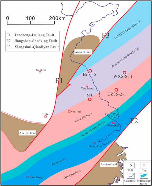
FIGURE 9. Sedimentary facies in the transgressive systems tract of sequence I in the Lower Yangtze [modified from (Ma, 2009)]. The fill colors represent different sedimentary facies. In the LYR area, tidal flat-lagoon facies, restricted platform facies, open platform facies, marginal slope facies, and shelf facies are developed.
The central-southern SYSB is located in the eastern part of the LYR and exhibits the same sedimentary facies as the whole LYR with a northeasterly distribution (Figure 10). Based on the analysis of drilling, logging, and seismic data in the study area, it is concluded that tidal flat lagoon facies, restricted platform facies, open platform facies, marginal slope facies, and shelf facies have sequentially developed from northwest to southeast (Figure 10).
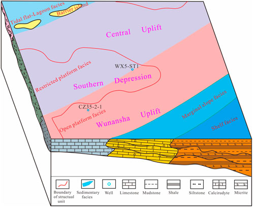
FIGURE 10. Sedimentary facies in the transgressive systems tract of sequence I in the central-southern SYSB. The fill colors represent different sedimentary facies. In the study area, tidal flat lagoon facies, restricted platform facies, open platform facies, marginal slope facies, and shelf facies are developed.
The basin distribution in the LYR is inherited compared to the previous period and is still distributed in the northeast direction (Figure 11). However, compared to the previous period, the sedimentary system has been altered, mainly marine clastic rocks are developed, and carbonate rocks are moderately less developed. This basin is generally characterized by deep water in the middle and shallow water on both sides.
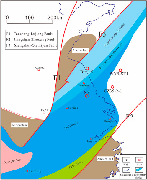
FIGURE 11. Sedimentary facies in the highstand systems tract of sequence I in the LYR [modified from (Ma, 2009)]. The fill colors represent different sedimentary facies. In the LYR area, tidal flat-lagoon facies, foreshore-shoreface facies, shelf facies, and delta facies are developed.
From northwest to southeast, the LYR led to the development of tidal flat-lagoon facies, foreshore-shoreface facies, shelf facies, and delta facies successively, and the shelf facies have developed the largest area (Figure 11). The sediment source in this period essentially originated from the ancient land on the north and south sides.
During this period, the sedimentary facies developed in the central-southern SYSB were similar to those in the LYR, and the water deepened from northwest to southeast. Only the western part of the study area presents a sedimentary process, and the central-eastern areas have been raised and denuded (Figure 12). By analyzing drilling, logging, and seismic data in the study area, tidal flat lagoon facies, foreshore-shoreface facies, and shelf facies were developed in the study area from northwest to southeast (Figure 12).
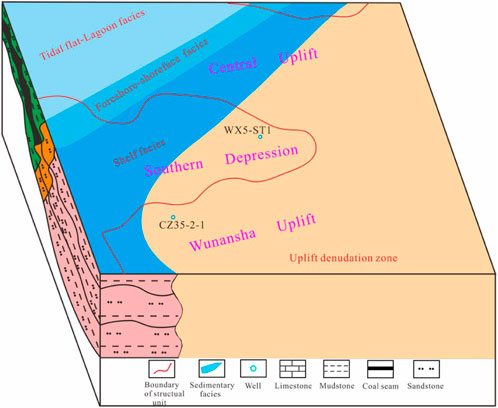
FIGURE 12. Sedimentary facies in the highstand systems tract of sequence I in the central-southern SYSB. The fill colors represent different sedimentary facies. In the study area, tidal flat lagoon facies, foreshore-shoreface facies, and shelf facies are developed.
During the period of the transgressive systems tract of sequence II, the basin was still distributed in a northeast direction (Figure 13) and majorly developed with marine clastic rocks, with deep water in the middle part and shallow water in the north. The sedimentary system has also been changed, and the fluvial facies have developed in the northern region. Additionally, along the southeast direction, delta facies or littoral facies, shelf facies, and littoral facies have been successively developed (Figure 13). Sediment sources in this period all originated from the ancient lands of both sides.

FIGURE 13. Sedimentary facies in the transgressive systems tract of sequence II in the LYR [modified from (Ma, 2009)]. The fill colors represent different sedimentary facies. In the LYR area, fluvial facies, delta facies or littoral facies, shelf facies, and littoral facies are developed.
During this period, the sedimentary system in the central-southern SYSB was still distributed in the northeast direction (Figure 14). From northwest to southeast, the water gradually gets deeper. By analyzing drilling, logging and seismic data in the study area, it is concluded that fluvial facies are developed in the northern area. Along the southeast direction, delta facies, swamp-lagoon facies, foreshore-shoreface facies and shelf facies are developed (Figure 14). The sedimentary sources in this period all originated from ancient lands on both sides (Figure 14).
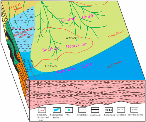
FIGURE 14. Sedimentary facies in the transgressive systems tract of sequence II in the central-southern SYSB. The fill colors represent different sedimentary facies. In the study area, fluvial facies, delta facies, swamp-lagoon facies, foreshore-shoreface facies, and shelf facies are developed.
Drilling and seismic data interpretation have revealed that the Permian Longtan-Dalong Formation has formed the tidal and swamp mudstone and coal seam in the understudy area. The kerogen type was mostly type III and the organic carbon content was high, generally in the range of 1.1%–3.2%, which represents a good medium source rock. The vitrinite reflectance (Ro) of source rocks in the Longtan Dalong Formation is in the interval of 1.2%–2.3% with an average of 1.95%, which has reached the stage of high maturity and overmaturity. The favorable reservoirs mainly include sandstones of delta facies and fluvial facies in the Permian Longtan Formation, Upper Cretaceous and Paleogene systems, as well as carbonate rocks of platform facies, marginal slope facies, and platform marginal shoals in Lower Triassic Qinglong Formation. Most of the deep reservoirs are chiefly featured by their low-porous and low-permeability values, and the properties of the reservoir gradually enhance upward. Current studies show that tectonism controlled fracture development in tight reservoirs can significantly improve reservoir properties (Li, 2019; Li, 2020; Li, 2022a; Li, 2022b). Due to the multi-phase tectonic movements in the study area, this evolved secondary pores and cracks in the sedimentary layers (especially carbonate rocks), leading to porosity enhancement. The regional cap rocks mainly include mudstones of the Lower Permian Qixia Formation, Upper Permian Longtan Formation, and mudstones of the Cretaceous Pukou Formation, and many local cap rocks are also developed.
Former studies disclosed that the southern Depression of the SYSB experienced four evolutionary stages, which are: the epicontinental sea in Late Paleozoic-Early Triassic, uplift erosion in the Late Triassic-Early Cretaceous, the extensional faulted basin in the Late Cretaceous-Paleogene, and the continental depression basin in Neogene-Quaternary. However, the central Uplift and Wuansha Uplift experienced only three stages of evolution, which are the epicontinental sea in the Late Paleozoic-Early Triassic, uplift erosion in the Late Triassic-Paleogene, and the continental depression basin in Neogene-Quaternary. Due to various tectonic evolutionary histories, remarkable differences in hydrocarbon generation processes of Permian source rocks are detected. In the present investigation, typical wells of various structural units are selected for burial history analysis (Figure 15).
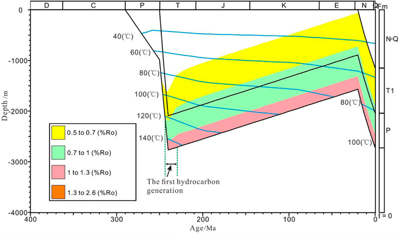
FIGURE 15. Burial history analysis of well CZ35-2-1 in the Wunansha Uplift of the SYSB. The fill colors represent different stages of maturity evolution. The P label represents Permian; Tq represents the Qinglong Formation of Triassic; and N-Q represents the Neogene–Quaternary.
The WX5-ST1 well is located in the eastern part of the southern Depression of the SYSB, and the burial history indicates that the Permian source rocks only reached the first hydrocarbon generation in the Early Triassic. Although such rocks were reburied after the late Cretaceous–Paleogene and Neogene–Quaternary, they did not regenerate hydrocarbons due to the reduced geothermal gradient and insufficient burial depth (Wang, 2014). The western part of the southern Depression in the SYSB is the Late Cretaceous sedimentary center, with large strata thickness and secondary hydrocarbon generation from Permian source rocks that may occur in this area.
Well CZ35-2-1 is located in the Wunansha Uplift of the SYSB. The performed burial history analysis reveals that the Permian source rocks also experienced only one generation of hydrocarbons in the Early Triassic and did not produce hydrocarbons again in the next period. Similar to the tectonic evolution history of the Wunansha Uplift, the Permian source rocks in the central Uplift have only one hydrocarbon generation in the Early Triassic.
The tectonic activities in the understudy region at the Early Triassic and Neogene-Quaternary were mainly dominated by integrated uplift and subsidence, and faults were not well developed. The oil and gas produced by Permian source rocks in these two periods are mostly accumulated in the reservoirs close to the hydrocarbon generation centers, which mainly form self-generation and self-accumulation reservoirs of the Permian (Figure 16). Among them, the early Tthe hydrocarbon productionriassic oil and gas reservoirs have been broadly distributed in the understudy region (including the central Uplift, the southern Depression, and the Wunansha Uplift), while the Neogene-Quaternary oil and gas reservoirs are only found in the western part of the southern Depression where secondary hydrocarbon generation may have occurred.
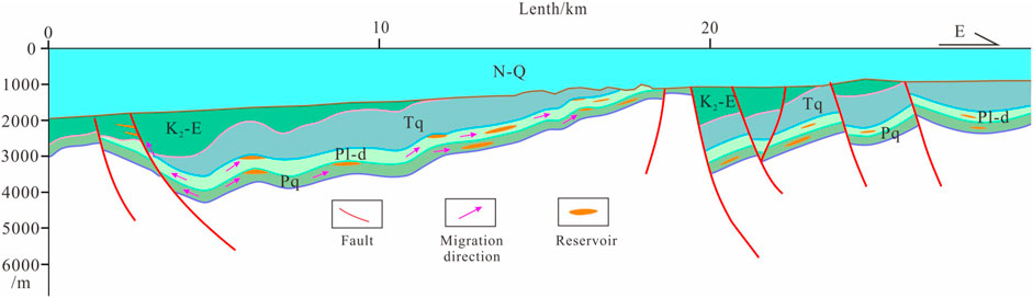
FIGURE 16. Predicted oil-gas accumulation mode of Permian in the central-southern SYSB (Line B position has been demonstrated in Figure 1). The fill colors represent different strata. The Pq label represents the Qixia Formation of Permian; Pl-d represents the Longtan-Dalong Formation of Permian; Tq represents the Qinglong Formation of Triassic; K2-E represents the Late Cretaceous- Paleogene; and N-Q represents the Neogene–Quaternary.
The southern Depression of the SYSB has been incorporated into the development of the extensional fault basin in the Late Cretaceous-Paleogene. On the one hand, the faults destroyed the oil and gas reservoirs formed in the early stages. On the other hand, the oil and gas produced by the secondary hydrocarbon production of Permian source rocks in the western part of the southern Depression can be transported along faults, unconformities, and other transport systems to shallow traps, which essentially constitute Permian generation-Mesozoic accumulation reservoirs and Permian generation-Cenozoic accumulation reservoirs generation (Figure 16). Such accumulation modes may only exist in the western part of the southern Depression.
Due to the comprehensive control of tectonic evolution and geothermal gradient, there are noticeable discrepancies in the process of hydrocarbon generation and favorable oil and gas accumulation modes of Permian source rocks among different structural units. The tectonic evolution history of the central SYSB Uplift is mostly similar to that of the Wunansha Uplift. Permian source rocks experienced only one hydrocarbon generation in the Early Triassic, and the strata suffered a severe squeeze and developed many reverse faults subjected to the Indosinian movement in the Late Triassic. The reverse fault destroyed the oil and gas reservoirs formed in the early stages. For this reason, in the central Uplift and the Wunansha Uplift, we should focus on seeking tectonically stable blocks since the Early Triassic where Permian self-generation and self-accumulation oil and gas reservoirs may exist. In the eastern part of the southern Depression of the SYSB, due to the low tensile strength in the Late Cretaceous-Paleogene and thin stratigraphic sedimentation, only one hydrocarbon generation occurred in the early Triassic. Therefore, rigorous oil and gas exploration in this area should be focused on self-generation and self-accumulation Permian reservoirs. However, the high tensile strength and deposition of thick strata in the western areas of the southern Depression may have produced secondary hydrocarbons in the Late Cretaceous-Paleogene and Neogene-Quaternary. In this area, apart from searching for Permian self-generation and self-accumulation oil and gas reservoirs in stable blocks, we should also focus on finding Permian generation-Mesozoic accumulation and Permian generation-Cenozoic accumulation reservoirs formed by secondary hydrocarbon generation of Permian source rocks.
After a detailed analysis of sedimentary facies and oil and gas accumulation factors in the study area, we came to the following main conclusion:
(1) The Permian sequence in the central-southern SYSB is consistent with the LYR. The middle and lower parts of the Permian developed a relatively complete second-order sequence (i.e., sequence I), while the upper part of the Permian only developed the transgressive systems tract of another second-order sequence (i.e., sequence II).
(2) The sedimentary system in the central-southern SYSB can be compared with the LYR. The transgressive systems tract of sequence I essentially developed restricted and open platform facies. The highstand systems tract is largely undeveloped in the study area and is predicted to develop only in the northwest of the southern Depression with shelf facies. The transgressive systems tract of sequence II essentially incorporates into the development of delta facies and swamp-lagoon facies.
(3) Thermal evolution of Permian source rocks was controlled by tectonic evolution and paleothermal gradient. Except for the possible presence of secondary hydrocarbon generation in the western part of the southern SYSB Depression, other areas experienced only one hydrocarbon generation in the Early Triassic.
(4) Different tectonic units exhibit different oil-gas accumulation modes. The central Uplift, Wunansha Uplift, and Southern Depression in the SYSB should focus on prospecting for Permian self-generation and self-accumulation reservoirs, and the western part of the Southern Depression of the SYSB should mainly look for Permian self-generation and self-accumulation reservoirs, as well as Permian generation-Mesozoic accumulation and Permian generation-Cenozoic accumulation reservoirs.
The original contributions presented in the study are included in the article/Supplementary Material, further inquiries can be directed to the corresponding authors.
MW: substantial contributions to the conception and design of the work and writing of the original draft. LH: interpretation of the drilling data; construction of the stratigraphic framework; sedimentary evolution analysis. BL: interpretation of the seismic section; writing—review and editing; and supervision. YZ: evaluation of source rocks; establishment of the burial mode. JP: tectonic evolution analysis. All persons who have made substantial contributions to the work reported in the manuscript, including those who provided editing and writing assistance but who are not authors, are named in the Acknowledgments section of the manuscript.
This study was financially supported by the earthquake science and technology spark program of the China Earthquake Administration (XH22014A) and the National Natural Science Foundation of China (41606079).
The authors would like to thank the reviewers who gave many constructive suggestions on the manuscript. They would like to express their gratitude to EditSprings (https://www.editsprings.cn) for the expert linguistic services provided.
Authors MW, LH, BL, YZ, and JP were employed by Oil and Gas Survey and China Geological Survey.
All claims expressed in this article are solely those of the authors and do not necessarily represent those of their affiliated organizations, or those of the publisher, the editors and the reviewers. Any product that may be evaluated in this article, or claim that may be made by its manufacturer, is not guaranteed or endorsed by the publisher.
Cai, L., Guo, X., Xu, Z., Zhang, X., Li, W., Xiao, G., et al. (2018a). Depositional environment of upper paleozoic in the central uplift of the south Yellow Sea Basin. ACTA SEDIMENTOL. SIN. 36 (4), 695–705. doi:10.14027/j.issn.1000-0550.2018.124
Cai, L., Xiao, G., Guo, X., Wang, J., Wu, Z., and Li, B. (2018b). Evaluation of upper paleozoic and mesozoic source rocks in well CSDP-2 and marine oilandhas exploration prospect in the south Yellow Sea Basin. ACTA PET. SINIA 39 (6), 660–673. doi:10.7623/syx6201806005
Cai, L., Xiao, G., Wan, H., Zeng, Z., Zhang, X., Guo, X., et al. (2021a). Multi-stage accumulation of the meso-paleozoic marine hydrocarbon in central uplift of South Yellow sea: Exploration significance of borchole CSDP-2. J. Jilin Univ. 51 (2), 307–324. doi:10.13278/j.cnki.jjuese.20200256
Cai, L., Zhang, X., Guo, X., Zeng, Z., Wang, S., Pang, Y., et al. (2021b). Effective hydrocarbon-bearing geological conditions of the permian strata in the south Yellow Sea Basin, China: Evidence from borehole CSDP-2. J. Petroleum Sci. Eng. 196, 107815–107821. doi:10.1016/j.petrol.2020.107815
Chen, C., Xu, C., Qian, D., Yu, Q., Huang, M., Zhou, L., et al. (2020). Growth and health status of Pacific white shrimp, Litopenaeus vannamei, exposed to chronic water born cobalt. J. East China Univ. Technol. Sci. 43 (2), 137–145. doi:10.1016/j.fsi.2020.03.011
Dai, C., Yang, Y., and Yan, G. (2005). Modelling of burial and hydrocarbon-generation histories of Meso-Paleozoic marine residual basins in South Yellow Sea and its geologic significance. Oil Gas Geol. 26 (1), 49–56. doi:10.3321/j.issn:0253-9985.2005.01.008
Hu, F. (2010). Hydrocarbon resources potential study in mesozoic-palaeozoic marine strata in the south Yellow Sea Basin. Offshore oil 30 (3), 1–8. doi:10.396/j.issn.10008-2336.2010.03.001
Lei, B., Chen, J., Liang, J., Zhang, Y., and Li, G. (2018). Tectonic deformation and evolution of the south Yellow Sea Basin since indosinian movement. Mar. Geol. Quat. Geol. 38 (3), 45–54. doi:10.16562/j.cnki.0256-1492.2018.03.004
Lei, B., Zhang, Y., Wang, M., Chen, J., Liang, J., and Wang, W. (2022). Structural characteristics and hydrocarbon exploration prospect of the laoshan uplift in the south Yellow Sea Basin. Mar. Geol. Quat. Geol. 42 (2), 131–143. doi:10.16562/j.cnki.0256-1492.2021101201
Li, H., Qin, Q., Zhang, B., Ge, X., Hu, X., Fan, C., et al. (2020). Tectonic fracture Formation and distribution in ultradeep marine carbonate gas reservoirs: A case study of the maokou Formation in the jiulongshan gas field, sichuan basin, southwest China. Energy & Fuels 34, 14132–14146. doi:10.1021/acs.energyfuels.0c03327
Li, H. (2022a). Research progress on evaluation methods and factors influencing shale brittleness: A review. Energy Rep. 8, 4344–4358. doi:10.1016/j.egyr.2022.03.120
Li, H., Tang, H., Qin, Q., Zhou, J., Qin, Z., Fan, C., et al. (2019). Characteristics, formation periods and genetic mechanisms of tectonic fractures in the tight gas sandstones reservoir: A case study of xujiahe Formation in YB area, sichuan basin, China. J. Petroleum Sci. Eng. 178, 723–735. doi:10.1016/j.petrol.2019.04.007
Li, H., Zhou, J., Mou, X., Guo, H., Wang, X., An, H., et al. (2022b). Pore structure and fractal characteristics of the marine shale of the longmaxi Formation in the changning area, southern sichuan basin, China. Front. Earth Sci. 10, 1018274. doi:10.3389/feart.2022.1018274
Li, Z., Yang, B., Wang, J., Han, Z., and Wu, Q. (2022). Geochemical characteristics and hydrocarbon generation history of Mesozoic-Cenozoic lacustrine source rocks in the South Yellow Sea Basin,offshore eastern China. Oil &Gas Geol. 43 (2), 419–431. doi:10.11743/ogg20220214
Liang, J., Xu, M., Chen, J., Zhang, Y., Wang, J., Lei, B., et al. (2021). The response of the Indosinian Movement to the South Yellow Sea basin and its influence on the hydrocarbon geological conditions. Geol. Bull. China 40 (2/3), 252–259. doi:10.12097/j.issn.1671-2552.2021.2-3.002
Ma, L., Chen, H., Dong, Y., Xia, J., Sun, F., and Yang, L. (2007). A critical role for the loop region of the basic helix-loop-helix/leucine zipper protein Mlx in DNA binding and glucose-regulated transcription. Oil Gas Geol. 28 (1), 35–44. doi:10.1093/nar/gkl987
Ma, Y., Chen, H., and Wang, G. (2009). Atlas of tectonic-lithofacies paleogeography in south China (Sinian-Neogene). Beijing, China: Science Press.
Marghani, M., Zairi, M., and Radwan, A. (2022). Facies analysis, diagenesis, and petrophysical controls on the reservoir quality of the low porosity fluvial sandstone of the Nubian formation, east Sirt Basin, Libya: Insights into the role of fractures in fluid migration, fluid flow, and enhancing the permeability of low porous reservoirs. Mar. Petroleum Geol. 147, 105986. doi:10.1016/j.marpetgeo.2022.105986
Mi, L., Wu, K., Liu, Z., Zhu, X., Geng, M., Zhang, Y., et al. (2022). Favorable exploration field analysis of Mesozoic-Paleozoic in South Yellow Sea basin from the distribution characteristics of marine source rocks in the Yangtze region. China Offshore Oil Gas 34 (2), 1–13. doi:10.11935/j.issn.1673-1506.2022.02.001
Qiu, E., Yang, F., Zhang, R., and Zhou, X. (2018). Seismic and sedimentary facies analysis and prediction of favorable Permian source rocks in the South Yellow Sea basin. Mar. Geol. Quat. Geol. 38 (3), 96–106. doi:10.16562/j.cnki.0256-1492.2018.03.009
Radwan, A. (2021a). Modeling the depositional environment of the sandstone reservoir in the middle miocene sidri member, badri field, gulf of suez basin, Egypt: Integration of gamma-ray log patterns and petrographic characteristics of lithology. Nat. Resour. Res. 30, 431–449. doi:10.1007/s11053-020-09757-6
Wang, L., Ye, J., and Wu, C. (2005). Petroleum geological characteristic of pre-Tertiary in south Yellow Sea Basin. Nat. Gas. Ind. 25 (7), 1–3.
Wang, M., Chen, X., Lei, B., and Zhu, X. (2018). Current status and problems of oil and gas exploration in South Yellow Sea basin. Mar. Geol. Front. 34 (11), 20–25. doi:10.16028/j.1009-2722.2018.11003
Wang, M., Jiang, X., Lei, B., Huang, L., and Pan, J. (2023). Tectonic evolution and its control on oil–gas accumulation in southern East China Sea since the Jurassic. Front. Earth Sci. 10, 1015832. doi:10.3389/feart.2022.1015832
Wang, M., Pan, J., Gao, H., Huang, L., and Li, X. (2022). Mesozoic basin evolution and hydrocarbon potential in north South China Sea and south East China Sea. Earth Sci. Front. 29 (2), 1–9. doi:10.13745/j.esf.sf.2021.7.8
Wang, M., Zhang, X., Meng, X., Chen, X., Zhu, X., and Lin, M. (2016). Hemagglutinin-esterase-fusion (HEF) protein of influenza C virus. Mar. Geol. Front. 32 (7), 28–45. doi:10.1007/s13238-015-0193-x
Wang, M., Zhang, X., Wu, Z., Xiao, G., Wang, J., and Wang, A. (2014). Tectonic evolution of southern depression in the South Yellow Sea basin and its hydrocarbon accumulation in Permian. J. China Univ. Min. Technol. 43 (2), 271–278. doi:10.13247/j.cnki.jcumt.2014.02.006
Wang, M., Zhang, Y., Pan, J., Huang, L., Chen, X., Luo, D., et al. (2020). Geological structure of the large section in eastern China’s sea areas and its constraint on comprehensive stratigraphic division. Geol. China 47 (5), 1474–1485. doi:10.12029/gc20200513
Yang, Q., and Chen, H. (2003). Tectonic evolution of the North jiangsu-South Yellow Sea Basin. Petroleum Geol. Exp. 25 (Supplement), 562–565. doi:10.3969/j.issn.1001-6112.2003.z1.008
Yang, S., Hu, S., Cai, D., Feng, X., Gao, L., and Lu, J. (2003). Geothermal field and thermal-tectonic evolution of the southern part in the South Yellow Sea Basin. Chin. Sci. Bull. 48 (14), 1564–1569. doi:10.3321/j.issn:0023-074X.2003.14.017
Ye, Z., Liang, X., Ma, L., Zhang, T., and Xu, K. (2006). An approach to exploration direction of oil-gas in the marine residual basins of independent Lower Yangtze Block. Chin. J. Geol. 41 (3), 523–548. doi:10.3321/j.issn:0563-5020.2006.03.014
Zhang, M., Gao, S., and Tan, S. (2018). Geological characteristics of the meso-paleozoic in South Yellow Sea Basin and future exploration. Mar. Geol. Quat. Geol. 38 (3), 24–34. doi:10.16562/j.cnki.0256-1492.2018.03.002
Zhang, T., Zhu, W., Hu, S., Chen, C., Gao, S., Chen, Z., et al. (2021). Structural characteristic and its genetic mechanism of central uplift in South Yellow Sea Basin. Earth Sci. 46 (10), 3481–3495. doi:10.3799/dqkx.2020.380
Keywords: South Yellow Sea Basin (SYSB), central-southern part, Permian, sequence, sedimentary facies, oil and gas accumulation mode
Citation: Wang M, Huang L, Lei B, Zhang Y and Pan J (2023) Permian sedimentary evolution and hydrocarbon accumulation effects in the central-southern South Yellow Sea Basin. Front. Earth Sci. 11:1176929. doi: 10.3389/feart.2023.1176929
Received: 01 March 2023; Accepted: 12 April 2023;
Published: 09 May 2023.
Edited by:
Hu Li, Southwest Petroleum University, ChinaReviewed by:
Xiujian Ding, China University of Petroleum (Huadong), ChinaCopyright © 2023 Wang, Huang, Lei, Zhang and Pan. This is an open-access article distributed under the terms of the Creative Commons Attribution License (CC BY). The use, distribution or reproduction in other forums is permitted, provided the original author(s) and the copyright owner(s) are credited and that the original publication in this journal is cited, in accordance with accepted academic practice. No use, distribution or reproduction is permitted which does not comply with these terms.
*Correspondence: Long Huang, aHVhbmdsb25nMDkxOUAxMjYuY29t, Yunbo Zhang, emhhbmd5YjIwMTRAZm94bWFpbC5jb20=
Disclaimer: All claims expressed in this article are solely those of the authors and do not necessarily represent those of their affiliated organizations, or those of the publisher, the editors and the reviewers. Any product that may be evaluated in this article or claim that may be made by its manufacturer is not guaranteed or endorsed by the publisher.
Research integrity at Frontiers
Learn more about the work of our research integrity team to safeguard the quality of each article we publish.