 Chunyu He1
 Yani Lin
 Tianze Zhang
95% of researchers rate our articles as excellent or good
Learn more about the work of our research integrity team to safeguard the quality of each article we publish.
Find out more
ORIGINAL RESEARCH article
Front. Earth Sci. , 02 August 2023
Sec. Structural Geology and Tectonics
Volume 11 - 2023 | https://doi.org/10.3389/feart.2023.1132837
This article is part of the Research Topic Basins and Related Tectonics View all 11 articles
The Songliao Basin is a large Mesozoic–Cenozoic continental basin with multiple sedimentary cycles. It has experienced the influence of multidirectional and different structural stresses in the peripheral structural belt, resulting in a complex geological structure. The continental clastic deposits at the depression of the Quantou Formation in the shallow part of the basin, including the Fuyu oil layer and the Yangdachengzi oil layer, are the primary exploration and development target. The structure and faults are the dominant factors controlling the hydrocarbon accumulation in the upper member of the Quantou Formation in the central Songliao Basin. In this study, we finely interpret the three-dimensional structure of the third member of Quantou Formation in the ZY block by the integration of well logging and seismic data and then analyze the stratigraphic distribution and fracture characteristic and the tectonic development history of the Yangdachengzi oil layer. The results show that the Yangdachengzi oil layer is a monoclinic structure from the southeast to northwest. It has four third-level structural units, the Mofantun nose structure, Yumin nose structure, Zhaoyuan nose structure, and Zhaoyuan western nose structure, which form the structure-lithostratigraphic trap zones in the study area, in which a total of 80 traps for the Yangdachengzi oil layer has been identified with the total area of about 58.06 km2. Faults are highly developed in the central depression of the Songliao Basin. The ZY block is dominated by the extensional-strike-slip faults. The main fault direction is mostly north–northeast, and the secondary fault direction is mostly north–northwest. The complex tectonic activities determine the formation mechanism and the evolution of faults. The faults in this block can be classified as early-stage, middle-stage, late-stage, and long-term faults. The long-term fault is the major fault type of the five fault bundles, and it acts as the main channel for oil and gas migration. In addition, the reservoir is an above-generation and below-storage model. This study provides evidence for the hydrocarbon accumulation model of the Quantou Formation.
Since the discovery of Daqing Oilfield in 1959, the Songliao Basin has become the most important oil- and gas-producing area in China and has made great contributions to the development of China’s oil industry. The Songliao Basin is a large continental rift basin developed in the Paleo-Pacific tectonic domain, Mongol-Okhotsk Ocean tectonic domain, and Paleo-Asian Ocean tectonic domain (Hu et al., 2005; Li et al., 2012a; Liu et al., 2020a; Liu et al., 2022b). The rift is the main manifestation of continental extensional structures. Numerous studies focused on the developing mechanism of continental extensional structures (Yang et al., 2019; Zhang and Dong, 2019; Lin and Li, 2021; Xiang et al., 2022; Liu et al., 2023), including the following: 1) Continental rifting is driven by the upwelling of mantle plume; e.g., the Kenya Rift in the East Africa is formed by the upwelling of the Afar mantle plume and Kenya mantle plume (Wilson, 1966; Macgregor, 2015; Pirajno and Santosh, 2015; Ge and Hou, 2018; Yao et al., 2018; Jia et al., 2021). 2) Continental margin extension is caused by subduction slab rollback and subduction zone retreat. For example, the Aegean wide rift basin is caused by the retraction of the African subduction plate under the Mediterranean ridge. When the extension began, large low-angle detachment faults started to develop in the upper crust, and then, in the later stage, high-angle normal faults were developed with the decrease of extension (Gautier et al., 1999; Jolivet and faccenna, 2000; Chen et al., 2014). 3) The gravitational collapse of the thickened crust drives the extension. For instance, the collapse of post-orogenic extension is responsible for the formation of the large-scale extension basin and range province in western North America. The low-angle normal faults developed in the upper crust received rotational shear deformation in the extensional deformation at first, and then, the high-angle rotating normal faults and tilting fault blocks were developed in the late stage (Eaton, 1982; Rehrig, 1986; Ren and Li, 1998; Chen et al., 2014). 4) The extension can be formed by the stress field in the strike-slip zone, like the Los Angeles Basin and the Sacramento Basin, which are formed by the long-term strike-slip movement and local turning of the San Andres fault zone (Powell and Weldon, 1992). The research on strike-slip faults has gone through more than 100 years. The internationally famous San Andreas Fault is a right-latera transform fault formed by the NW (northwest) movement of the Pacific plate relative to the North American plate (Reading, 2009; Wesnousky, 2005; Scharer and Streig, 2019). The Tan-Lu strike-slip fault in China, which is similar to the San Andreas Fault, has produced some strike-slip pull-apart bsins in the northeastern part of China and has also had a certain impact on the Songliao Basin (Feng et al., 2022).
The Songliao Basin is one of the important rift basins in the Northeast Asian rift system. The driving mechanism has been argued by numerous researchers. It is generally believed that the closure of the Paleo-Asian Ocean, the subduction of the Mongol-Okhotsk Ocean plate, and the subduction of the Paleo-Pacific plate offer the driving force of the Songliao Basin (Huang et al., 2016; Yang et al., 2019; Zhang and Huang, 2019; Feng et al., 2021; Lin and Li, 2021; Dong et al., 2022; Guan et al., 2022; Xiang et al., 2022). The Songliao Basin has experienced four tectonic stages: the basement formation and transformation stage, the rift extension stage, the cooling depression stage, and the tectonic inversion stage (Hou et al., 2004). As the result of repeated extension and strike-slip activities, multi-stage fault systems can be observed inside the basin: the first-stage faults were developed in the Middle–Late Jurassic period. The basement of the basin was strongly deformed by the large-scale left-lateral strike-slip activities in the northern section of the Tan-Lu fault system and derived NNE, NNW, and near NS trending secondary faults. The second-stage NNE-trending extensional faults were developed during the thermal uplift rifting stage from the Late Jurassic to the Early Cretaceous period. The stress of the basin tectonic system gradually changed from left-lateral compression–torsion to extension, and the faults’ trend began to parallel the Paleo-Pacific subduction belt. The third-stage of NNE-trending ‘Y’-shaped faults was developed in the subsidence stage from the middle and late Early Cretaceous to the early Late Cretaceous period, and the basin underwent a weak extension. The fourth-stage faults were developed in the Late Cretaceous. The basin was subjected to the compressional stress from the southeast direction and formed a large number of NE-trending compressional faults and NNW-trending tension–torsion faults (Ren et al., 2002; Ge et al., 2009; Li et al., 2014; Huang et al., 2016; Deng et al., 2021; Feng et al., 2021; Jiang et al., 2021; Feng et al., 2022). A study of the Songliao Basin would be challenging because of the complex geodynamic background and unique magmatic activity characteristics.
The Yangdachengzi oil layer is a high-yield oil production unit and one of the key exploration targets in the Songliao Basin (Xi et al., 2015). The faults of the Yangdachengzi oil layer are developed in multiple phases and provide good conditions for oil and gas migration and accumulation. The fault-block, fault-nose, and anticline traps that relate to the tilted Yangdachengzi oil layer are distributed around the fault-concentrated belt. The high density and small scale of the faults cause the strong vertical heterogeneousness in the deeply buried Yangdachengzi oil layer (Luo, 2010; Guo, 2019; Mei et al., 2020). The study of the deformation characteristics and evolution patterns of the faults is critically important for understanding the influence of faults on oil and gas migration, yet it has not been fully discussed in the previous research. In this study, by integrating the three-dimensional (3D) seismic, logging, and drilling data in the central depression area of the ZY block of the Songliao Basin, we study the structural style and fault developing characteristics of the Yangdachengzi oil layer in detail. The fracture patterns and characteristics are summarized, and the controlling mechanism of the different stages of faults is demonstrated. The results provide a better understanding of the fault system and its relation with the hydrocarbon distribution. By analyzing the tectonic evolution characteristics of the late Early Cretaceous–early Late Cretaceous in the Songliao Basin, the relationship between tectonic movements and fault-concentrated belts is recognized, which provides a theoretical basis for the control of fault belts on the reservoirs during the deposition of the Quantou Formation in the Songliao Basin.
The Songliao Basin lies in the northeast of China. It is geologically located at the intersection of the North China plate, the Pacific plate, and the Siberian plate. The Songliao basin is a typical fault-depression composite structural basin. The basin is controlled by the regional faults. The western boundary is the Nenjiang–Baicheng Fault and the Greater Khingan Range, the eastern boundary is the Yilan–Yitong Fault and the Zhangguangcai Range, the southern boundary is the Chifeng–Kaiyuan Fault and the Yinshan–Yanshan orogenic belt, and the northern boundary is the Xunke–Tieli Fault and the Lesser Khingan Range. The basin interior is separated by multiple sets of deep faults (Ren et al., 2002; Shan et al., 2009; Lu et al., 2022). The strikes of the main fault zones are north-northeast–southwest-west (NNE–SWW), nearly east–west (EW), and northwest–southeast (NW–SE). The Nenjiang–Baicheng Fault in the western boundary and the Dedu–Da’an fault, Qinggang–Gan ‘an fault, and Siping–Dehui fault in the interior are all strike-slip faults (Deng et al., 2021). The basin can be further divided into seven first-order tectonic belts—that is, the western slope, northern plunge, central depression, NE uplift, SE uplift, SW uplift, and Kailu depression. The major oil- and gas-producing areas are the Daqing anticline, Qijia–Gulong, Sanzhao, and Changling sags, and the Chaoyanggou terraces developed in the central depression zone (Feng et al., 2010; Xi et al., 2015). The study area covers the eastern part of the central depression and the NW slope of the SE uplift zone (Figure 1A).
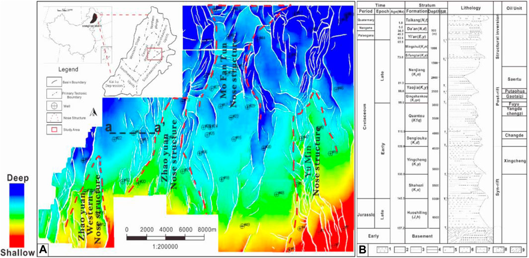
FIGURE 1. (A) Study location. The Songliao Basin is a large Mesozoic–Cenozoic sedimentary basin in northeast China, spanning Heilongjiang Province, Jilin Province, Liaoning Province, and the Inner Mongolia Autonomous Region. The whole basin can be divided into seven first-order tectonic belts. The red small frame is the location of the work area, which is located on the east side of the central depression. The figure shows the top surface structure of the Yangdachengzi oil layer; the overall strata are low in the NW and high in the SE. The section crossed #50 well is shown in Figure 3: (B) brief stratigraphic histogram of the Songliao Basin (Wang et al., 2007; GE et al., 2010). The Yangdachengzi oil layer is located at the top of the Quantou Formation, with a buried depth of 3,000–3,400 m. It was deposited in the late Early Cretaceous, 100 Ma ago, and the lithology is mainly sandy mudstone. 1—Conglomerate; 2—sandstone; 3—mudstone and shale; 4—coal; 5—loose sediment; 6—volcanic rock; 7—pyroclastic rock; 8—granite; 9—metamorphic rock.
The strata can be divided into four main periods based on their tectonic deformation characteristics: the foreland period (Triassic–Jurassic strata), the syn-rift period (Huoshiling Formation–Yingcheng Formation), the post-rift period (Denglouku Formation–Nengjiang Formation), and the tectonic inversion period (Sifangtai Formation–Taikang Formation), corresponding to the basement tectonic layer, fault depression layer, depression layer, and inversion tectonic layer, respectively (Figure 1B). Clear regional unconformities can be found between the layers (Feng et al., 2010). Since the Middle Jurassic, the collision and subduction between the Siberian plate, the Sino–Korean plate, and the Paleo-Pacific plate have caused the deep asthenosphere to rise upward, and the crust has continuously thinned and stretched, forming the early structure of the Songliao Basin (Yang et al., 2021).
At the end of the Late Jurassic, the Songliao Basin began to extend and rift and form numerous fault basins with various scales and structural styles. In the early stage of the Late Cretaceous, the cooling effect in the lithosphere caused the uneven sinking of the crust. The basin entered the thermal depression stage (Li et al., 2021). After that, the rift basins unified and formed a large lake basin, and the Quantou Formation started to deposit. During this period, the influence of the basement structure and the extension range decreased and formed normal faults in different scales during the sedimentary period of the Quantou Formation. The strikes of most of these faults were dominated by the north–south (NS) direction, but some areas were dominated by the NNE or NNW direction. The dominant trend often followed the structural trend from the fault depression period, reflecting the control of the deep structure. An individual graben or graben system is indicated by the V-shaped faults or nested V-shaped faults on the seismic section (Sun et al., 2013a). The depression period holds the largest density of faults, and lesser faults can be found in the inversion period, while the fault depression period contains the least faults. The faults are varied in scale, displacement, and extension range, which revealed the characteristics of multistage activities of the faults (Liu et al., 2017).
The Quantou Formation (K1q) that deposited in the large-scale depression lake basin mainly consists of fluvial–lacustrine clastic sediments, which covers almost the entire basin. Several transient transgression events and weak volcanic activity occurred during the deposition of the Quantou Formation, and the intensity of fault activity was greatly reduced (Ge et al., 2010; Fan et al., 2017). The Yangdachengzi oil layer lies in the upper part of the Quantou Formation (Figure 2). The meandering river deposits of Yangdachengzi oil layer were formed in a humid–arid alternating climate and gentle terrain background with slow subsidence of the basement. The lithology is mainly mudstone, fine sandstone, mudstone-bearing coarse siltstone, mudstone-bearing fine sandstone, coarse siltstone-fine sandstone, fine sandstone-coarse siltstone, and calcium sandstone (Li et al., 2013). The sand body developed in the lower Yangdachengzi oil layer shows a clear reduction of natural gamma ray (GR) value. The middle and upper parts of the Yangdachengzi oil layer are dominated by the thick purplish red mudstone, which host the thin sandstone layers. The GR curve gradually changed upward from a box type to a toothed bell type, indicating an increasing level of river sinuosity. The sedimentary environment gradually transitions from a delta deposition to a meandering river deposition.
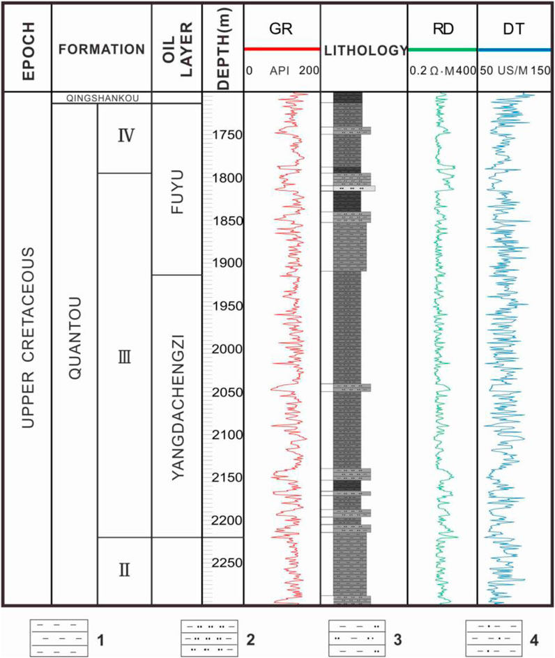
FIGURE 2. No. 55 comprehensive histogram. The Yangdachengzi oil layer is located in the middle and lower part of the Quansan section. The lithology is purple, gray–green, dark purple mudstone, silty mudstone and gray argillaceous siltstone, siltstone, and brown–gray oil-bearing siltstone. The resistivity curve is an alternate distribution of toothed low resistance and finger, spike, and thick-layered medium and high resistance. This stratum belongs to fluvial facies–delta facies deposit under an oxidizing environment, and the thickness of this well area generally is 369.0–484.0 m. 1—mudstone; 2—muddy siltstone; 3—silt mudstone; and 4—sandy mudstone.
The main purpose of this work is to study the influence of the Yangdachengzi oil layer structure and fracture system on oil and gas migration and accumulation. An integration of 3D seismic data, logging, and drilling data is used. The study area covers the eastern part of the central depression and the NW slope of the SE uplift zone (Figure 1A). It is covered by five 3D seismic working areas with a total coverage of 797 km2. These 3D seismic data come from different vintages, and the frequency of seismic data is about 35 Hz. The two-way travel time of seismic data is mainly in the range of 900–1,600 ms. A total of 53 wells encounter the Yangdachengzi oil layer, with 10 wells drilling through.
Based on the evaluation of data, a synthetic seismogram is necessary to generate the identification of seismic horizons. It was also used to correlate the geological data with the well logs’ data to justify the seismic trace data. We use the existing drilling data to finely calibrate the seismic geological horizon. Then, starting from the known well points, through the well profile, amplitude change, waveform characteristics, and time difference law, the standard seismic reflection layer is finely compared and tracked to establish a backbone interpretation profile. The bottom of the Qingshankou Formation with stable distribution and easy identification is used as the marker layer, which can guarantee the reliability of the interpretation scheme. Seismic attributes assisted us to obtain the information obtained from seismic data based on empirical results. The main principle of the coherence attribute technology is to represent the lateral heterogeneity of the formation by the similarity of adjacent seismic traces in the 3D seismic data volume to determine the faults in the formation. Using the coherence attribute technology, horizontal slice technology, and 3D visualization technology, we carried out detailed correlation of the interpreted layers and faults and construction of fault space combination. Through the study of structural characteristics and fault system analysis in the study area, we strengthen our understanding of the Yangdachengzi oil layer and establish an accumulation model.
The top surface of the Yangdachengzi oil layer is about 130 ms below the standard interface of the Fuyu oil layer. The seismic section has the seismic reflection characteristics of medium–high frequency, medium–strong energy, and medium–strong continuous wave peak. The overall lateral waveform is stable and continuous, and the seismic response characteristics of the whole area were relatively uniform. The top surface of the middle Yangdachengzi oil layer is about 190 ms below the standard interface of the Fuyu oil layer. It has the seismic reflection characteristics of medium–high frequency, weak–medium strong energy, and medium–strong continuous wave peak. The lateral waveform is relatively stable, continuous, and locally different. The top surface of the lower Yangdachengzi oil layer is about 240 ms below the standard interface of the Fuyu oil layer, which has the seismic reflection characteristics of medium–high frequency, weak–medium strong energy, and medium–strong continuous wave trough. The bottom surface of the Yangdachengzi oil layer is located about 280 ms below the standard interface of the Fuyu oil layer, with medium–high frequency, medium–strong energy, and medium–strong continuous trough reflection. Seismic reflection characteristics are relatively stable laterally and had good continuity (Figure 3).
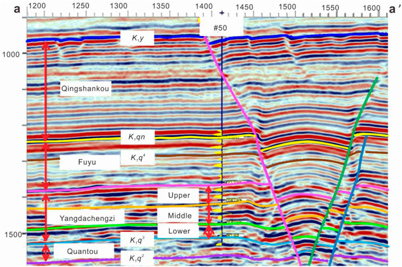
FIGURE 3. Seismic horizon calibration profile of well #50. The seismic reflection interface at the bottom of the Qingshankou Formation has good continuity and strong amplitude, which can be used as a good seismic standard layer. Below it is the Fuyu oil layer and the Yangdachengzi oil layer. The seismic reflection interface is stable and continuous.
Faults in the Yangdachengzi oil layer are highly developed. The plane density is large, the distribution is uneven, and it has the characteristics of zoning. With the help of coherent attributes, we identify more than 600 large and small faults in the study area and divide the faults into five fault-concentrated belts with a strike of NNE–NNW (Figure 4). They appear in the nose structure area, which is susceptible to tensile stress and produced a series of concentrated belts parallel or nearly parallel to the long axis of the structure. The faults are mainly located in the depression layer between the Quantou Formation and Qingshankou Formation. In general, the fault has the following characteristics: 1) The fault is a trans-tensional straight normal fault with an NS strike and a dip angle of 70°. 2) Various style combinations are densely developed to form the fault zones. According to the profile combination characteristics of the faults, the extensional tectonic styles could be classified as graben, horst, fault-step, and Y-shaped types of faults. The density was the largest during the depression period, and the profile shows a combination of V-shaped graben or stepped faults. 3) The faults that ruptured horizons are complex, and the number of faults that developed over the long term was significant. We identified 53 long-term faults in the five fault zones. The fault trough is between 10 and 130 m. The maximum extension length is 13,066 m and generally less than 5,000 m. The overall trend is mainly in the NNW and NNE directions, which shows obvious sinistral characteristics. The fault’s surface is curved, which is a typical indicator of a strike-slip fault. 4) The fault density is large in a plane view, and it is nearly parallel, oblique, orthogonal, en echelon, and broom-like (Table 1). In general, the faults are trending SN, and the inner part is separated by flower-like fault belts that formed trap groups. Following the distribution law of fault superposition diagram, the fault system changed little. The fault spread outward from the bottom to the top of the Yangdachengzi oil layer, with a small offset and good inheritance (Figure 4).
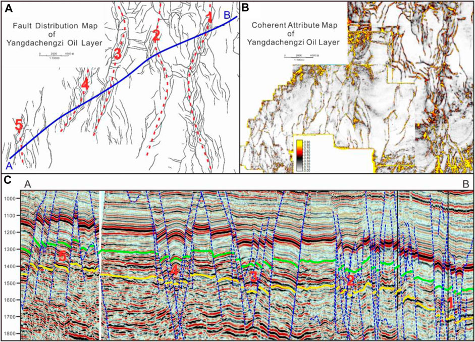
FIGURE 4. (A) Fault distribution map of the Yangdachengzi oil layer in the Zhaoyuan area. The fault is very developed. It is generally divided into five fault zones, with a strike of NNE–NNW. (B) Assistance of coherent attributes in the interpretation of faults. The comparison shows that the fault interpretation is reliable and the fault plane correlation combination is reasonable. (C) Seismic profile of A–B. From SW to NE are the No. 5, No. 4, No. 3, No. 2, and No. 1 fault zones.
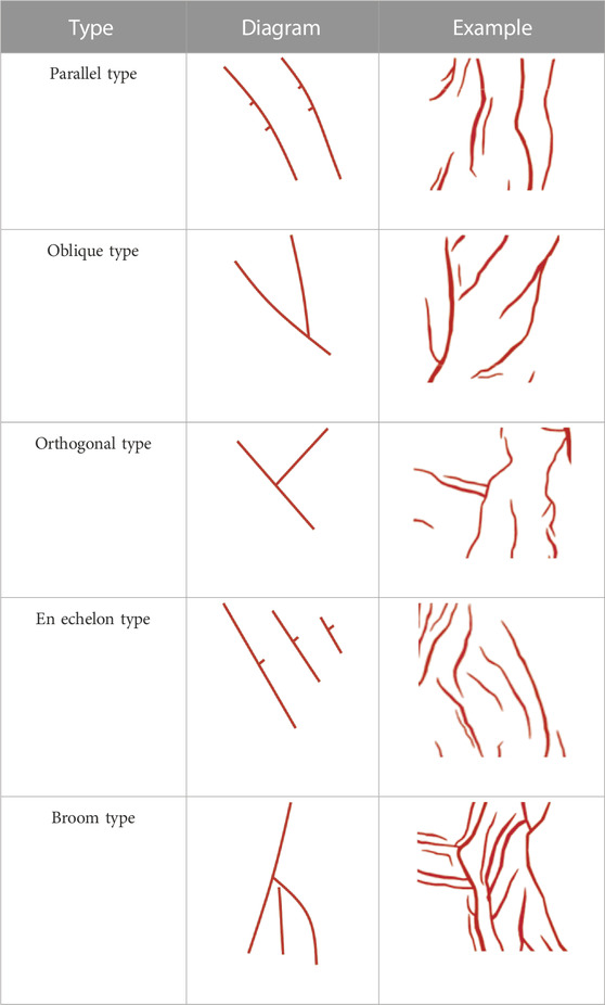
TABLE 1. Fracture space combination classification.
The extensional tectonic style in the ZY block is not the traditional extension formed under positive stretching or arching, but is an oblique extension with the characteristics of torsion. From the seismic section, the fault combination generally presents a graben–horst combination mode, and the fault style mainly includes graben-type, horst-type, step-like, Y-shaped and X-shaped conjugate, and negative flower-like faults (Table 2). 1) The step-like faults form in a step-like style on the main survey line section. A series of normal faults form a step-like fault zone, and the stratigraphic tendency is the opposite of the fault tendency. 2) The combination of the main fault and reverse inclined secondary fault forms a Y-type fault. The Y-type faults are composed of main faults and secondary small faults, which usually intersect in a Y-shaped pattern, and multiple Y-shaped combinations form a complex Y-shaped pattern. 3) The X-type conjugate faults are formed by a cross combination of two groups of faults in different directions, at different levels, and over different periods, and the acute angle was about 70°. 4) Under the condition of a regional tension–torsion stress field, the negative flower-like fault accompanies the strike-slip fault, and it spreads upward in the form of a bifurcation from a main fault. Many groups of small faults develop at both ends of the fault, showing flower-like characteristics on the section. There are many grabens and horsts in the study area. For example, in the No. 5 fault belts, the SW side is composed of a series of reverse fault terraces with a tendency toward the SW direction, and the NE side is composed of reverse fault terraces with opposite tendencies that formed horsts between them. In the No. 4 and No. 3 fault belts, reverse fault-steps as well as Y-shaped and X-shaped conjugate faults can be identified, which are combined to form a graben–horst model (Figure 4).
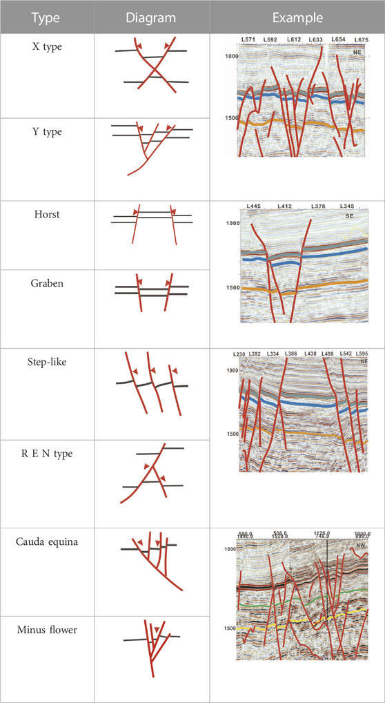
TABLE 2. Classification of fault structural types.
In the regional structure, the study area is located in the central depression area and the NW slope area of the SE uplift zone and developed the Zhaoyuan nose structure, which inclines to the NW direction. According to the structural map of each layer, the deep and shallow structures of the entire work area are the same. In general, it is a NW-dipping monoclinic structure. The stratum trend is oblique to the near NS fault at a low angle, and the structure is not developed in some areas. The Sanzhao depression in the NW is a long-term developed inherited depression (only a part was in this area), and it is also the sedimentary and subsidence center, which shows a gradual upward trend around this area. The Zhaozhou structure in the east also presents a local depression pattern, and four nose structures are developed in the central uplift belt (Figure 5E): the Mofantun nose structure, the Yumin nose structure, the Zhaoyuan nose structure, and the Zhaoyuan western nose structure. Among them, the Mofantun nose structure is located between the two depressions in the east and west, and the fault-nose structure with the long-arm shape in nearly NS trend is developed, and the terrain is relatively gentle (Figure 5C). The NE side of the Yumin nose structure is adjacent to the depression, and the slope of the western side is relatively slow (Figure 5D). The overall trend of the fault-nose structure is NNW; the Zhaoyuan nose structure overall trend is NNE, with east and west sides of the fault depression development (Figure 5B). The trend of the Zhaoyuan western nose structure is in a NS direction, the terrain is steep, and the fault-nose structure extends northward for a short length (Figure 5A). They were uplifted by the faults to form a graben–horst model.
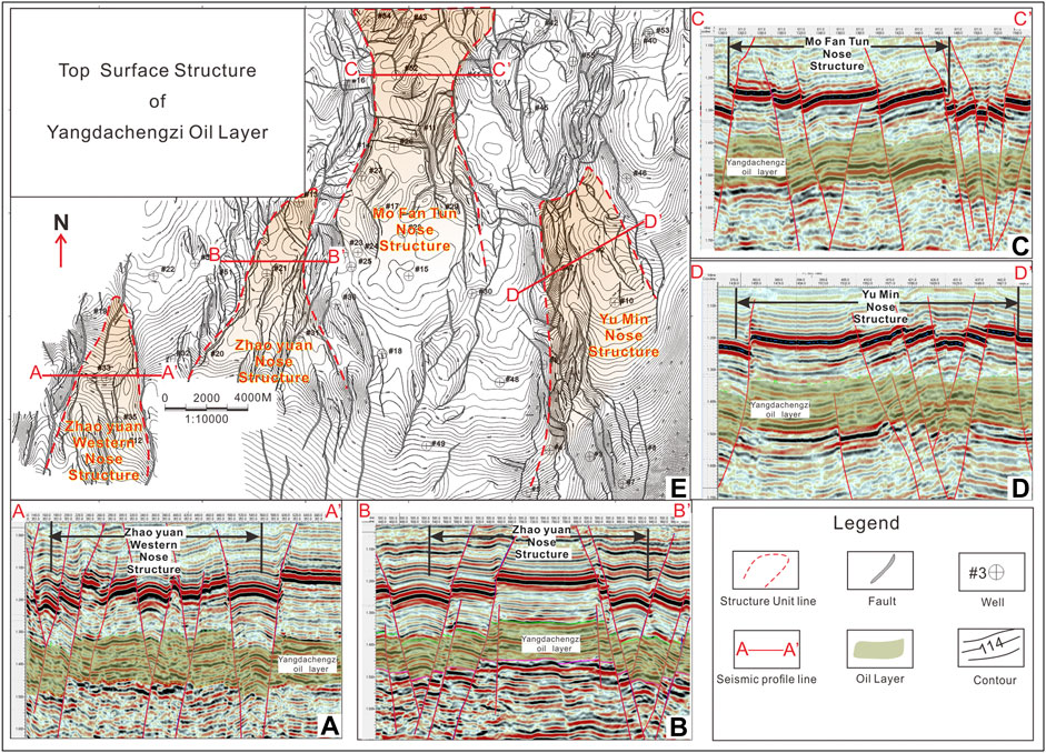
FIGURE 5. (A) The seismic profile of Zhaoyuan Western Nose structure. (B) The seismic profile of Zhaoyuan Nose structure. (C) The seismic profile of Mo Fan Tun Nose structure. (D) The seismic profile of Yu Min Nose structure. (E) Top structural map of the Yangdachengzi oil layer is a monoclinic structure inclined to the NW. The red dashed line delineate the boundaries of the nose structures.
The developing stage of the faults play a significant role in the formation and evolution of the basin, and it also assists the migration and accumulation of oil and gas. Depending on which strata the fault cuts through, the fault systems in the study area are divided into early-stage fault, middle-stage fault, late-stage fault, and long-term fault (Figure 6). The early-stage faults were extensional faults formed in the rift period of the basin, generally cutting off the Jurassic or Denglouku Formations. The middle-stage faults were formed in the sedimentary period of Qingshankou Formation in the depression area of the basin, and a large number of small normal faults were produced, which are mainly distributed in the upper part of the Quantou Formation. The fault distance gradually decreases in the shallow layer and mostly disappears in the Yaojia Formation. The late-stage faults were generated from the end of the deposition of the Nenjiang Formation that interrupted the Yaojia Formation. The long-term faults were formed during the fault-depression period of the basin and developed in the later tectonic movement over a long period of time. The long-term faults are identified as the long extension on the plane view and with large fault distance on the vertical seismic profile. The upper part of the long-term faults disconnects the Yangdachengzi oil layer, and the following interrupts the Putaohua oil layer at the end of the Yaojia group sedimentary period. The fault distance decreases gradually from deep to shallow. The long-term faults are the main controlling faults which determine the growth of fault belts and act as the main channels for oil and gas migration in this area. In general, the early-stage fault develops in the fault-depression period, the middle-stage fault develops in the depression period, the late-stage fault develops in the tectonic inversion period, and the long-term fault continues to develop during deposition.
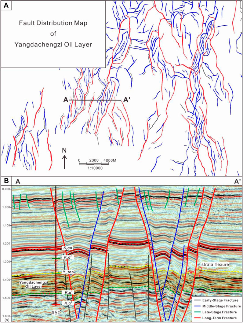
FIGURE 6. (A) Fault distribution map of the Yangdachengzi oil layer. The red is a long-term fault, the blue is a medium-stage fault, and the black is an early-stage fault. (B) Fault seismic profile, with the location (A–A′) shown in (A). Obvious flexures along the fault can be observed in the strata near the fault.
As a fault-depression superimposed basin, the Songliao Basin contains a large number of faults. The fault systems of Quantou Formation in the Songliao Basin are formed on the basis of the pre-existing faulted structure, which then experience the tension-twist deformation during the depression stage of the basin, and finally reconstruct during the reversal deformation stage. Therefore, clarifying the activities of different stages of the Songliao Basin is helpful in revealing the genetic mechanism and evolution of the fault belts of the Yangdachengzi oil layer in the Quantou formation. After carefully analyzing the fault developing stages and characteristics of stratigraphic distribution, we create a tectonic development history profile (Figure 7). Based on the regional geology and the interpretation results, the analysis of the structure and sedimentary development in this area is as follows:
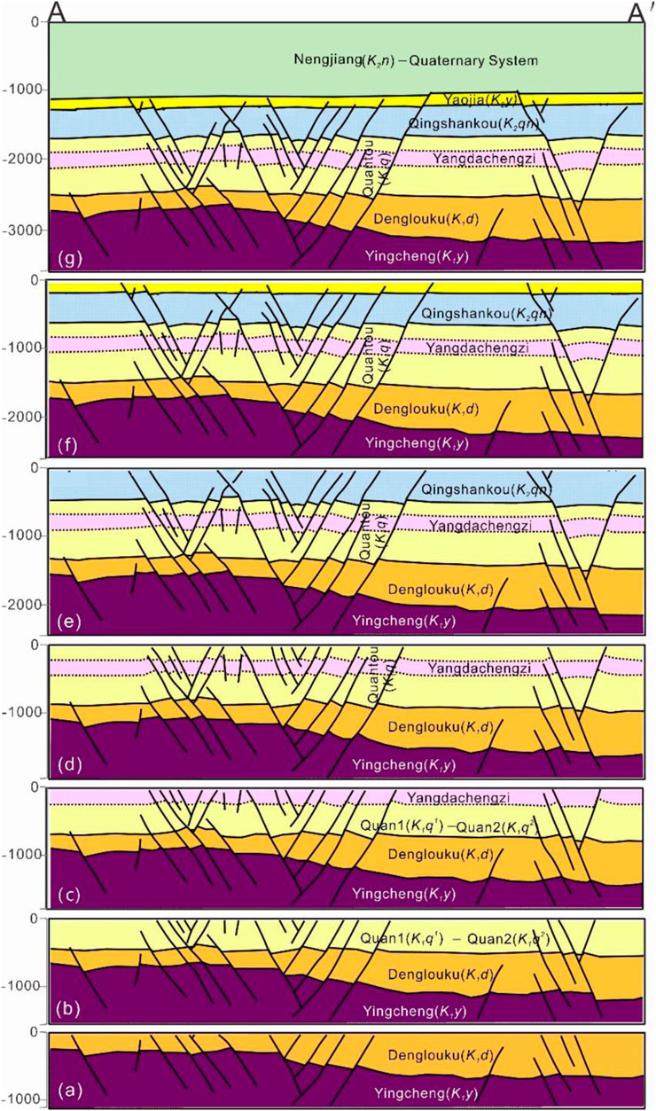
FIGURE 7. Structural development history section of the Yangdachengzi oil layer. The location of the fault (A–A′) is shown in Figure 6A. (A–G) Developmental history of the Yingcheng Formation to Nenjiang Formation. The duration of the faults is different. The early-stage faults were active during the deposition of the Yingcheng Formation and Denglouku Formation, the middle-stage faults were active before the deposition of the Yaojia Formation, and the late-stage faults disconnected the Yaojia Formation. Long-term faults continue to operate in each period and play an important role in oil and gas migration and accumulation.
Figure 7A shows the Yingcheng–Denglouku Formation sedimentary period. During the early stage of the basin development, the joint effect of the closure of the Mongolian-Okhotsk Ocean and the oblique subduction of the Izenagi Plate generated a left-lateral compression and torsion stress, resulting in extensive magmatic activity within the basin (Hou et al., 2010; Yang et al., 2019). Under the NNE trending left-lateral system, a secondary NS compression stress field was generated in the basin basement, resulting in NNE- and NNW-trending fault systems, which had a profound impact on the basin (Ge et al., 2010). After the Late Jurassic, the upwelling of mantle plumes produced thermal domes on Earth’s surface, and the geopotential energy of these domes drove the crust to undergo gravity spreading, resulting in NNE-oriented tensile stress. The stress regime of the basin began to transform from left-handed compression and torsion to extension. During the sedimentation period of the Yingcheng Formation, the Songliao Basin developed into a horseshoe-shaped rift basin (Li et al., 2019a; Li et al., 2019b). In the late stage of rifting (Yingcheng Formation sedimentation period), the direction of extension gradually changed from NNE to near EW to ESE, which was related to the WNW–ESE crustal extension and detachment (Yang et al., 2019). During the sedimentation period of the Denglouku Formation, tectonic movement was relatively weak. Because of the weakening of the EW-oriented tensile stress, the basin began to gradually sink regionally, and the basin type transitioned from a rift basin to a depression basin.
Figures 7B–D) show the Quantou Formation sedimentary period. After the deposition of the Denglouku Formation, the basin entered a stage of significant and stable subsidence, and tectonic movement tended to stabilize. The fault activity during the deposition of the Quantou Formation exhibited obvious inheritance and co-deposition characteristics. The fault activity during the deposition of the Quantou Formation can be divided into two stages. The early stage was characterized by a co-deposition normal fault developed at the bottom of the Quantou Formation. Obvious flexures along the fault can be observed in the strata near the fault, and these faults have a characteristic of decreasing vertical displacement from bottom to top (Figure 6B). The early fault activity was strong, and then, it gradually weakened and ceased upward, indicating an inherited activity of a long-existing fault. The late-stage fault developed at the end of the Quantou Formation deposition and is a co-deposition normal fault with extensional and rotational properties under regional differential subsidence (Wang et al., 2022a).
Figures 7E, F) show the Qingshankou Formation sedimentary period. From the late Early Cretaceous to the Late Cretaceous, the distribution range of igneous rocks significantly decreased towards the east and migrated from inland to coastal areas, indicating the eastward drifting of the Eurasian continent and the retreat of the ancient Pacific subduction plate, resulting in continental extension and the formation of weak NW–SE horizontal tension (Zhang et al., 2005; Tang et al., 2018; Fu et al., 2020; Lin and Li, 2021; Xiang et al., 2022). During the sedimentation of the Qingshankou Formation, a large number of densely distributed fault zones were formed in a belt shape, some of which inherited the pre-existing long-term faults. On the plane, they are closely arranged in parallel, en echelon, and braided patterns. The boundary of the fault belt has a larger fault scale, while the fault scale within the belt is smaller. Typical flower-like structures can be seen on the seismic profile, which has obvious strike-slip characteristics, reflecting the torsion stress state. In addition, there is a “V”-shaped trench system and a “Y”-shaped structural pattern, which cuts off the Quantou Formation. Some of the fault-concentrated belts are not connected to deep faults due to the horizontal detachment of the mudstone layer (Xie and Fu, 2013; Xie et al., 2015). The overall development of the fault-concentrated belt is controlled by the “weak zone” existing during the faulting period, e.g., pre-existing faults, volcanic vents, and uplift zones. The genesis of the fault zone can be divided into three types: 1) strike-slip, where a large-scale strike-slip fault developed in the Sanzhao area named the Xuzhong fault, which became active in the late sedimentation period of the Quantou Group, forming a “braided” fault zone (Li and Li, 2010; Li et al., 2012b). 2) Oblique rifting, where the early north–northwest-oriented basement faults intersect with the near-east–west extensional forces at an angle of approximately 60°, producing oblique tension. 3) Extension, where the NS-oriented faults are formed by the E–W extensional forces. Strike-slip force is prone to forming “braided” fault belts and flower-like fault combinations. Extensional force is prone to forming “parallel belt-shaped” fault zones, as well as “V”-shaped and “y”-shaped fault combinations. Meanwhile, the torsional force is prone to forming “en echelon” fault belts.
Figure 7G shows the Yaojia Formation–Nenjiang Formation sedimentary period. The sedimentation of the Yaojia Formation was during the early stage of basin inversion, where the extensional forces within the basin gradually disappeared, and only small faults developed near the base of the Yaojia Formation, while the long-term faults continued to develop. The subduction of the Pacific plate changed from the northwest to west–northwest direction (Hou et al., 2004), and the basin began to experience compression during the sedimentation of the Yaojia Formation. The compression stress direction was WNW–ESE, causing weak deformation in the fault plane (Gong et al., 2008). The sedimentation period of the Nenjiang Formation was the main period of the transformation of the faults, which experienced the “Nenjiang Movement” and strong compression in the basin (Huang et al., 2014; Liu et al., 2020). However, the tectonic movement did not cause any significant change in the strata or structural pattern, but resulted in a differential uplift within the basin (Chen et al., 2010). During the deposition of the Mingshui Formation, the most intense structural reversal occurred, resulting in a left-hand compressional and rotational deformation of the fault zone, forming the current structural pattern (Sun et al., 2013b).
The roles that faults play in hydrocarbon accumulation can be summarized as follows: 1) the migration channels for oil and gas migration, 2) the lateral sealing effect, and 3) the various traps related to faults (Guo, 2010; Liang et al., 2019; Wang et al., 2022b). The Yangdachengzi tight sandstone oil reservoir at the Quantou Formation was accumulated by above-generation and below-storage. The upper Qingshankou Formation was the oil source layer. Due to the difference of the geological structure, the overlying strata of the Qingshankou Formation in the eastern region were mudstone. There were many faults developed in the lower Qingshankou Formation, which can provide a good migration channel for oil and gas to the lower sandstone (Yang, 2022). Based on the geochemical analysis, some of the hydrocarbon in the Yangdachengzi oil layer migrated from the Sanzhao Depression on the NW side of the study area. The Fuyu oil layer on the footwall of the fault was laterally opposed to the source rock of the Qingshankou Formation on the hanging wall, and the oil and gas were directly transported from west to east to the Fuyu and Yangdachengzi oil layer (Sun et al., 2010; Huang et al., 2012; Wang et al., 2020). The distribution of the fault system and the development of sand bodies were the main controlling factors of hydrocarbon lateral migration and accumulation.
The fault-concentrated belt can provide both lateral sealing and vertical conduit system for oil and gas migration in the Songliao Basin. When the banded sand bodies in the river delta system across the fault got concentrated, the sand bodies were blocked by faults in the upward direction, which formed the lithologic-fault traps. When the sand bodies and the faults had the same striking, there was no barrier function in the updip direction and no formation conditions for favorable traps. At this time, the fault belts acted as NS migrating channels, and the oil and gas continued to migrate to the higher part of the structure and gradually accumulated in the traps away from the source rock (Chen et al., 2011; Mei et al., 2020). Four fault-nose structures were developed along five fault-concentrated belts in the study area, and a total of 80 traps are identified at the top of the Yangdachengzi oil layer, with the total area about 58.06 km2 (Figure 8). The trap types are mainly fault-block traps and fault-nose traps. The Yumin nose structure developed at the eastern side of the No. 1 fault concentrated belt, which formed a large number of fault-block traps inside. Because of the high and steep terrain in the southeast part of the study area, these fault-block traps have the characteristics of a small closure area and a high closure height, which are difficult to preserve hydrocarbons. The Mofantun nose structure developed between the No. 2 and No. 3 fault-concentrated belt, which formed several large fault-nose traps due to the flat terrain in the north part of the study area. The Zhaoyuan and Zhanyuan western nose structures developed on the side of the No. 4 and No. 5 fault-concentrated belt. The strata show an NW–SE trending direction, which agrees with the strike of the faults. Therefore, traps developed in these two nose structures are small in size and separated sparsely.
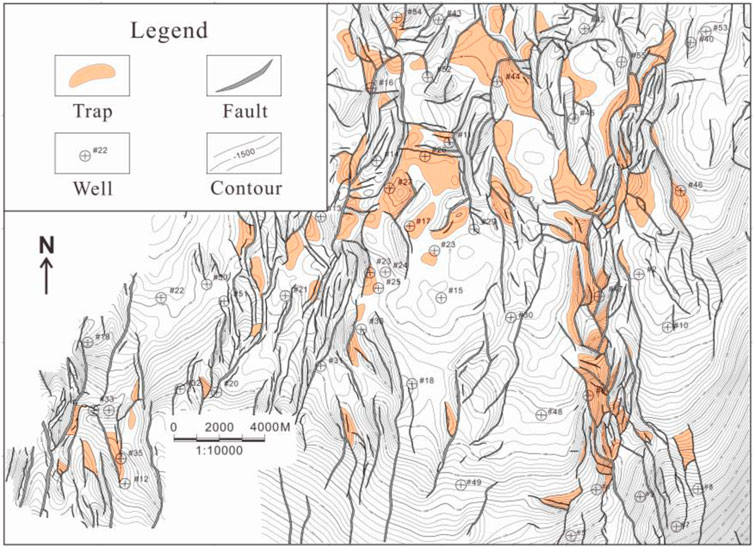
FIGURE 8. Trap distribution map for the top of the Yangdachengzi oil layer. Traps develop along the fault-concentrated belt; the size and number of traps depend on the relationships between faults and strata.
The structural style of the Fuyu and Yangdachengzi oil layers were controlled by horst, antithetic fault terrace, graben, and step-like fault. The degree of hydrocarbon enrichment is diverse in different structure types. The statistical results showed that the success rate of exploration wells with horst, antithetic fault terrace, graben, and step-like fault in the fault-concentrated belt decreased gradually (Chen et al., 2013). When the fault had large displacement, both sides of the horst were blocked by mudstone, forming good accumulation conditions. The height of the oil column increased with the fault displacement distance. The graben structure in the middle of the fault-concentrated belt has a low terrain, and then, lateral oil and gas can be blocked by the negative topography of the graben, resulting in the reduction of oil column height or completely blocking oil and gas. The horsts and step-like faults on either side of the dense fault zone were the favorable areas for hydrocarbon accumulation in the Yangdachengzi oil layer. As shown in Figure 9, part of the oil and gas migrated from west to east and part of the oil and gas migrated downward. The sand bodies cross the fault plane laterally. Because of the undeveloped induced fractures, the fault footwall had good lateral sealing, which was beneficial to the hydrocarbon accumulation and lithologic-fault trap establishment in the footwall (Luo., 2011). The hydrocarbon in the Fuyu oil layer migrated laterally along the sand body to the vicinity of the fault and continued to migrate downward along the fault to the Yangdachengzi oil layer due to the higher formation pressure in the upper layer. Then, the oil and gas migrated along the sand bodies to the structural high of the Yangdachengzi oil layer.
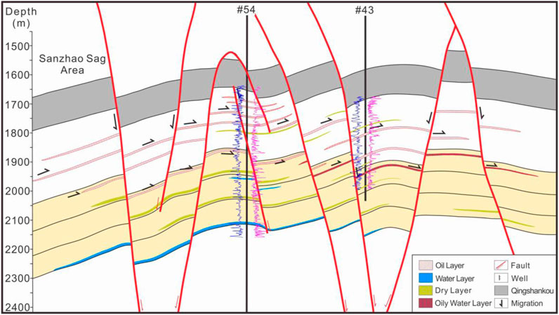
FIGURE 9. Oil–gas migration map. Eastward migration of oil–gas in the Sanzhao area. The oil and gas of the overlying Qingshankou Formation poured downward and accumulated in the Fuyu and Yangdachengzi oil layer (yellow background color) to form lithologic-fault traps. The Yangdachengzi oil layer has less oil, mainly gathered horst and reverse fault terrace parts with many dry and water layers.
According to the study results, we can draw the following conclusion:
1. The whole study area is a monocline structure striking in the SE–NW direction, with the stratigraphic strike and the nearly NS faults crossed obliquely at low angle. The local structure is undeveloped, and four nose-shaped tectonic units are formed.
2. The faults are highly developed in the study area, and the strikes are mainly in the NS direction. The dense fault zones are formed where fault density is large, and some faults were active in many stages. Five types of fault dense zones are categorized based on vertical characteristics, including step-like, graben, horst, Y-shaped, and X-shaped conjugated faults in herringbone and horsetail styles. In the plane view, the faults can be categorized into near-parallel, oblique, orthogonal, en echelon, and broom types.
3. We divide the fault system into early-stage, middle-stage, late-stage, and long-term fractures. The long-term fractures were formed during the basin rifting period. The basin developed for a long time in the later tectonic movement, featuring characteristics of long extension and large fault displacement distance, and the fault displacement distance gradually decreases from deep to shallow. The long-term fracture is the main controlling fault type and is the main channel for oil and gas migration.
4. The basement faults in the Songliao Basin were developed during the Jurassic period, which controlled the later sedimentary activities. From the end of Jurassic to the early Cretaceous, the basin experienced a fault depression period. In the late Cretaceous, it experienced a depression period. At the end of the Cretaceous, the structure began to reverse. Finally, the structure was finalized, forming a complex fault depression–depression superimposed basin. Clarifying the activities of different stages of the Songliao Basin is helpful in revealing the genetic mechanism and evolution of the fault belts of the Yangdachengzi oil layer in the Quantou formation.
5. Faults can act as channels for oil and gas migration and also provide good lateral sealing. It is conducive for an oil- and gas-shielding reservoir to form a lithology-fault trap. The horst and step-like faults are favorable places for oil and gas accumulation in the Yangdachengzi layer. Four fault-nose structures were developed along five fault-concentrated belts in the study area, and a total of 80 traps are identified at the top of the Yangdachengzi oil layer, with the total area of about 58.06 km2.
In conclusion, we discuss the relationship between tectonic movements and fault-concentrated belts, which provides a theoretical basis for the control of fault belts on the reservoirs during the deposition of the Yangdachengzi oil layer in the Quantou Formation in the central depression of the Songliao Basin. However, the microstructures cannot be recognized on the seismic profiles due to the limitations of the resolution for seismic data. In the next plan, we propose discovering the microfractures generated in the Yangdachengzi oil layer combined with advanced identification technology, which can give us a better understanding of crustal stress during the deposition period of the Quantou Formation in the study area.
The original contributions presented in the study are included in the article/Supplementary Material; further inquiries can be directed to the corresponding author.
Investigation: YaL; formal analysis: CH and YaL; data curation: JC and JM; writing–original draft preparation: CH, YaL, and TZ; writing–review and editing: YZ, CH, and YuL; and project administration: YaL. All authors contributed to the article and approved the submitted version.
This research was supported by the Sichuan Science and Technology Program (Grant No. 2022NSFSC0187) and Open Fund (Grant No. PLC20210102) of State Key Laboratory of Oil and Gas Reservoir Geology and Exploitation (Chengdu University of Technology).
Author JM was employed by Oil Production Company of Daqing Oilfield Company Ltd.
The remaining authors declare that the research was conducted in the absence of any commercial or financial relationships that could be construed as a potential conflict of interest.
All claims expressed in this article are solely those of the authors and do not necessarily represent those of their affiliated organizations, or those of the publisher, the editors, and the reviewers. Any product that may be evaluated in this article, or claim that may be made by its manufacturer, is not guaranteed or endorsed by the publisher.
Chen, F. W., Lu, S. F., Xu, Y. T., Li, J. J., and Wang, M. (2013). Types and favorable oil accumulation parts of fault dense belts in fuyang formation of Sanzhao depression, Songliao Basin. Earth Science-Journal China Univ. Geosciences 6, 1281–1288. doi:10.3799/dqkx.2013.125
Chen, F. W., Lu, S. F., Xu, Y. T., Wu, Z. Y., and Wei, X. J. (2011). Intensively faulted zones and their controlling on the hydrocarbon migration and accumulation: A case study of the wangfu depression, Songliao basin. Earth Science-Journal China Univ. Min. Technol. 40 (2), 235–239.
Chen, W. J., He, D. F., and Cui, B. L. (2014). Structural style and genetic mechanism of wide rifting. Adv. Earth Sci. 29 (3), 344–351. doi:10.11867/j.issn.1001-8166.2014.03.0344
Chen, X., Li, Z. Q., Chen, J. L., Li, H. Q., and Zhang, T. (2010). Determination of the reverse period of Songliao Basin, China. Geol. Bull. China 29 (2), 305–311. doi:10.3969/j.issn.1671-2552.2010.02.015
Deng, M., Zuo, Z. X., Qiu, Q., and Bai, F. (2021). Normal fault evolution in lishu fault depression, southern Songliao Basin. PETROLEUM Geol. Exp. 43 (2), 288–296. doi:10.11781/sysydz202102288
Dong, Y., Wang, S. M., Yu, Q., Chen, J. S., Yang, H., Ge, W. C., et al. (2022). Late Paleozoic tectonic magmatic evolution history of the northeastern China. Acta Petrol. Sin. 38 (8), 2249–2268. doi:10.18654/1000-0569/2022.08.04
Eaton, G. P. (1982). The Basin and Range Province origin and tectonic significance. Annu. Rev. s Earth Planet. Sci. 10, 409–440. doi:10.1146/annurev.ea.10.050182.002205
Fan, Q., Fan, T. L., Tian, J. J., Sun, M. H., and Li, Sh. (2017). Sequence stratigraphy and sedimentary evolution from the 4th member of Quantou Formation to the 3rd member of Nenjiang Formation in sifangtuozi area, Songliao Basin. PETROLEUM Geol. Exp. 39 (5), 593–602. doi:10.11781/sysydz201705593
Feng, Z. Q., Dong, L., Tong, Y., Feng, Z. H., Zhang, Sh., Wu, G. K., et al. (2021). Impacts of the closure of eastern Mongolia-Okhotsk Ocean on formation and evolution of Songliao Basin. OIL& Gas. CEOLOGY 42 (2), 251–264. doi:10.11743/ogg20210201
Feng, Z. Q., Jia, C. Z., Xie, X. F., Hu, M., Zi-hui, F., and Cross, T. A. (2010). Tectonostratigraphic units and stratigraphic sequences of the nonmarine Songliao basin, northeast China. Basin Res. 22 (1), 79–95. doi:10.1111/j.1365-2117.2009.00445.x
Feng, Z. Q., Li, M., Guo, Y. L., and Liu, G. X. (2022). Genetic analysis of typical strike slip faults and related basins in China. Earth Sci. Front. 29 (6), 206–223. doi:10.13745/j.esf.sf.2022.8.6
Fu, X. F., Shi, H. D., Meng, Q. A., Liu, B., Liang, J. P., He, J. L., et al. (2020). Controlling effects of the structure and deposition on the shale oil enrichment: Taking Formation qn1, in the Central Depression of Songliao Basin as an instance. Petroleum Geol. Oilfield Dev. Daqing 39 (3), 56–71. doi:10.19597/J.ISSN.1000-3754.202005011
Gautier, P., Brun, J. P., Moriceau, R., Sokoutis, D., Martinod, J., Jolivet, L., et al. (1999). Timing, kinematics and cause of aegean extension: A scenario based on a comparison with simple analogue experiments. Tectonophysics 315, 31–72. doi:10.1016/S0040-1951(99)00281-4
Ge, M., and Hou, G. T. (2018). Geodynamics of the East african rift System∼30 Ma ago. A stress field model. J. Geodyn. 117, 1–11. doi:10.1016/j.jog.2018.02.004
Ge, R. F., Zhang, Q. L., Wang, L. S., Xie, G. A., Xu, S. Y., and Chen, J. (2010). Tectonic evolution of Songliao Basin and the prominent tectonic regime transition in eastern China. Geol. Rev. 56 (2), 180–195.
Ge, R. F., Zhang, Q. L., Xu, S. Y., Wang, L. S., Xie, G. A., Chen, J., et al. (2009). Structure evolution and its kinetic setting of Changling fault depression in Songliao basin. Earth Sci. 33 (4), 346–358. doi:10.3969/jin1674-3636.2009.04346
Gong, F. X., Han, Y. H., Lin, G., Li, Z. A., and Liu, L. (2008). Mechanism of early post-rift normal faults in the central Songliao Basin, northeast China. Earth Sci. 4, 547–554. doi:10.3321/j.issn:1000-2383.2008.04.012
Guan, Q. B., Liu, H. H., Liu, Y. J., Li, S. Z., Wang, S. J., Chen, Z. X., et al. (2022). A tectonic transition from closure of the Paleo-Asian Οcean to subduction of the Paleo-Pacific Plate. Insights from early Mesozoic igneous rocks in eastern Jilin Province, NE China. Gondwana Res. 102, 332–353. doi:10.1016/j.gr.2020.05.001
Guo, X. J. (2019). Fracture characteristics and controls on reservoirs in fulongquan fault depression, Songliao Basin. J. Pet. Geol. 41 (5), 657–662. doi:10.11781/sysydz201905657
Guo, Y. P. (2010). Study on hydrocarbon accumulation patterns and control factors in fuyang reservoir, chaoyang area. J. Oil Gas Technol. 5, 171–175.
Hou, G. T., Feng, D. C., and Wang, W. M. (2004). Reverse structures and their impacts on hydrocarbon accumulation in Songliao basin. Oil Gas Geol. 25 (1), 49–54. doi:10.3321/j.issn:0253-9985.2004.01.009
Hou, G. T., Wang, Y. X., and Hari, K. R. (2010). The Late Triassic and Late Jurassic stress fields and tectonic transmission of North China craton. J. Geodyn. 50, 318–324. doi:10.1016/j.jog.2009.11.007
Hu, W. S., Lv, B. Q., Zhang, W. J., Mao, zh. G., Leng, J., and Guan, D. Y. (2005). An approach to tectonic evolution and dynamics of the Songliao Basin. Chin. J. Geol. 40 (1), 16–31. doi:10.3321/j.issn:0563-5020.2005.01.002
Huang, Sh. Q., Dong, S. W., Hu, J. M., Shi, W., Chen, X. H., and Liu, Z. Q. (2016). The Formation and tectonic evolution of the mongol-okhotsk belt. Acta Geol. Sin. 90 (9), 2192–2205. doi:10.3969/j.issn.0001-5717.2016.09.008
Huang, W., Wu, H. B., Shi, L. Z., Wang, S. B., and Wang, Z. Z. (2012). Oil and gas source and reservoir characteristic of Fuyu Reservoir of Chaochang area in north Songliao Basin. J. Central South Univ. Sci. Technol. 43 (1), 238–248.
Huang, X., Chen, K. Y., and Deng, Y. H. (2014). Evolved characteristics of fault T2 in south Songliao Basin. Petroleum Geol. Oilfield Dev. Daqing 4, 9–15.
Jia, S., He, D. F., Han, W. M., and Hu, B. (2021). Formation and evolution of the Kenya rift, the eastern branch of the East african rift system. Acta Geol. Sin. 95 (4), 1114–1127. doi:10.19762/j.cnki.dizhixuebao.2021035
Jiang, X. J., Peng, Y. B., Dong, X. J., Li, H. M., and Tu, Y. (2021). The remote role of Mongolia-Okhotsk Ocean: Evidences from the origin of rhyolite porphyry in yangpangou area, the southeast of inner Mongolia. Earth Sci. 46, 3057–3073. doi:10.3799/dqkx.2020.335
Jolivet, L., and Faccenna, C. (2000). Mediterranean extension and the Africa-Eurasia collision. Tectonics 19, 1095–1106. doi:10.1029/2000TC900018
Li, C., Liu, S. F., and Bai, Y. (2014). Differentiation of anomalous cretaceous post-rift subsidence in the southern Songliao Basin. Geoscience 28 (6), 1213–1224. doi:10.3969/j.issn.1000-8527.2014.06.012
Li, H., Hao, J., Song, W. C., Huang, T., Liu, Z., Zhang, Y., et al. (2019a). Formation and evolution of reservoir fractures in Yingcheng Formation of lishu fault depression, Songliao Basin. Bull. Mineralogy, Petrology Geochem. 38 (4), 802–809. doi:10.19658/j.issn.1007-2802.2019.38.071
Li, J. J., Wang, Z. Z., Zhang, Z. H., and Cheng, G. J. (2013). The sedimentary facies of member-3 of Quantou Formation in xinli Oilfield, Songliao Basin. Xinjiang Pet. Geol. 34 (5), 534–537.
Li, S. Q., Chen, F. K., Siebel, W., Wu, J. D., Zhu, X. Y., Shan, X. L., et al. (2012a). Late Mesozoic tectonic evolution of the Songliao basin, NE China. Evidence from detrital zircon ages and Sr–Nd isotopes. Gondwana Res. 22, 943–955. doi:10.1016/j.gr.2012.04.002
Li, X. L., and Li, X. J. (2010). Relationship between the fractal feature of fault T2 and the hydrocarbon of fuyang reservoir in Sanzhao sag. Petroleum Geol. Oilfield Dev. Daqing 29 (4), 13–17.
Li, Y. Y., Fu, X. F., and Zhang, M. X. (2012b). Fault deformation features and reservoir controlling mechanisms of Xujiaweizi fault depression in Songliao basin. Nat. Gas. Geosci. 23 (6), 979–988.
Li, Z. D., Wang, P., Li, L., Li, W., Xu, J. Z., and Liu, Y. K. (2019b). Study of sedimentary characteristic in Denglouku formation, southern Songliao basin, Northeast China. Carbonates Evaporites 34 (3), 1141–1155. doi:10.1007/s13146-018-0468-4
Li, Z. Q., Chen, J. L., Zou, H., Wang, C., Meng, Q. A., Liu, H. L., et al. (2021). Mesozoic–cenozoic tectonic evolution and dynamics of the Songliao Basin, NE asia: Implications for the closure of the paleo-Asian Ocean and mongol-okhotsk Ocean and subduction of the paleo-pacific ocean. Earth-Science Rev. 218, 103471. doi:10.1016/j.earscirev.2020.103471
Liang, J. P., Zhao, B., Chen, J. L., and Niu, W. (2019). Fault systems and their controlling actions on the petroleum distribution in North Songliao Basin. Petroleum Geol. Oilfield Dev. Daqing 38 (5), 126–134. doi:10.19597/J.ISSN.1000-3754.201906064
Lin, W., and Li, J. Y. (2021). Cretaceous two stage extensional tectonic in eastern Eurasia continent and its geodynamics. Acta Petrol. Sin. 37 (8), 2303–2323. doi:10.18654/1000-0569/2021.08.04
Liu, C. H. Y., Nicotra, E., Shan, X., Y, J., and Ventura, G. (2023). The Cretaceous volcanism of the Songliao Basin: Mantle sources, magma evolution processes and implications for the NE China geodynamics-A review. Earth-Science Rev. 237, 104294. doi:10.1016/j.earscirev.2022.104294
Liu, C. Y., Shan, X. l., Yi, J., Shi, Y. Q., and Ventura, G. (2022a). Volcanism at the end of continental rifting: The Cretaceous syn-rift to post-rift transition in the Songliao Basin (NE China). Gondwana Res. 111, 174–188. doi:10.1016/j.gr.2022.08.005
Liu, J. Q., Zhang, T., Lv, Y. Y., Zhang, M. D., Sun, T. W., J, G. P., et al. (2017). Controls of intensively faulted zones on hydrocarbon migration and accumulation: An example of Fuyu oil layer in Xingbei area. Songliao Basin Petroleum Geol. Exp. 39 (4), 453–460. doi:10.11781/sysydz201704453
Liu, K., Zhang, J. J., Xiao, W. J., Simon, W., and Igor, A. (2020a). A review of magmatism and deformation history along the NE Asian margin from ca 95 to 30 Ma: Transition from the Izanagi to Pacific plate subduction in the early Cenozoic. Earth- Sci. Rev. 209, 103317. doi:10.1016/j.earscirev.2020.103317
Liu, W., Tang, D. Q., Chen, M. Y., Zhang, Y. J., Chen, L., and Li, N. (2022b). Fault structure characteristics and evolution in the Gudian fault depression, southern Songliao Basin. Fault-Block Oil &. Gasfield 29 (6), 816–823. doi:10.6056/dkyqt202206015
Liu, Z. H., Song, J., Liu, X. W., Wu, X. M., and Gao, X. (2020b). Discovery of the Cretaceous-Paleogene compressional structure and basin properties of the southern Songliao Basin. Acta Petrol. Sin. 36 (8), 2383–2393. doi:10.18654/1000-0569/2020.08.07
Lu, T. J., Liu, X., Jiang, S., Zhang, L. L., Ning, J., Wang, H. T., et al. (2022). Study on late cretaceous sedimentary evolution and uranium mineralization in southern Songliao Basin. Uranium Geol. 38 (4), 607–617. doi:10.3969/j.issn.1000-0658.2022.38.053
Luo, Q. (2010). Fault systems and characteristics of their controlling reservoir formation in the northeast China. PETROLEUM Geol. Exp. 32 (3), 205–210. doi:10.3969/j.issn.1001-6112.2010.03.001
Macgregor, D. (2015). History of the development of the East african rift system: A series of interpreted maps through time. J. Afr. Earth Sci. 101, 232–252. doi:10.1016/j.jafrearsci.2014.09.016
Mei, X. H., Wu, X. S., Zhao, J. H., Zhang, Q., Liu, J. Y., and Wang, Q. (2020). Types of fault-intensive belts and their control on hydrocarbon accumulation: A case study of Yangdachengzi oil layer in fuxin uplift, Songliao Basin. Fault-Block Oil Gas Field 27 (1), 1–6. doi:10.6056/dkyqt202001001
Pirajno, F., and Santosh, M. (2015). Mantle plumes, supercontinents, intracontinental rifting and mineral systems. Precambrian Res. 259, 243–261. doi:10.1016/j.precamres.2014.12.016
Powell, R. E., and Weldon, R. J. (1992). Evolution of the san Andreas fault. Annu. Rev. Earth Planet. Sci. 20 (1), 431–468. doi:10.1146/annurev.ea.20.050192.002243
Reading, H. G. (2009). Characteristics and recognition of strike-slip fault systems. Sediment. Oblique-Slip Mob. Zones 2009, 7–26. doi:10.1002/9781444303735.ch2
Rehrig, W. A. (1986). Process of regional Tertiary extension in the western Cordillera: insights from the metamorphic core complexes. Geological Society of America Special Paper 208, 97–122. doi:10.1130/SPE208-p97
Ren, J. Y., and Li, S. T. (1998). Comparison between the faulted basin system in northeastern asia and the extension of The Basin and range province in western NorthNorth America. Geol. Sci. Technol. Inf. 17 (3), 8–12.
Ren, J. Y., Tamaki, K., Li, S., and Junxia, Z. (2002). Late Mesozoic and Cenozoic rifting and its dynamic setting in Eastern China and adjacent areas. Tectonophysics 344, 175–205. doi:10.1016/S0040-1951(01)00271-2
Scharer, K., and Streig, A. (2019). The san Andreas fault system: Complexities along a major transform fault system and relation to earthquake hazards. Transform Plate Boundaries Fract. Zones 2019, 249–269. doi:10.1016/B978-0-12-812064-4.00010-4
Shan, W., Liu, S. F., and Wu, J. (2009). Tectonic feature and strain pattern of Changling sag on the southern edge of Songliao basin, China. Geol. Bull. China 28 (4), 431–438.
Sun, Y. H., Bai, L., and Fu, X. F. (2013a). Genetic mechanism of T2 reflector fault dense zones in northern Songliao Basin. Earth Science-Journal China Univ. Geosciences 38 (4), 797–806. doi:10.3799/dqkx.2013.078
Sun, Y. H., Chen, Y. B., Li, X. S., Sun, J. G., and Fu, X. F. (2013b). Evolutionary sequence of faults and the formation of inversion structural belts in the northern Songliao Basin. Petroleum Explor. Dev. 40 (3), 296–304. doi:10.1016/s1876-3804(13)60036-1
Sun, Y., Ma, S. Z., Zhang, D. Z., Zhao, H., Yu, L. M., and Zhang, Y. B. (2010). The analysis of hydrocarbon accumulation characteristics and its main controlling factors in lithologic reservoirs area outside oil source area—example of Fuyu oil layer in the southern fuxin uplift of Songliao Basin. Geol. Rev. 55 (5), 693–700. doi:10.16509/j.georeview.2010.04.015
Tang, J., Xu, W. L., Wang, F., and Ge, W. C. (2018). Subduction history of the paleo-pacific slab beneath eurasian continent: Mesozoic-paleogene magmatic records in northeast asia. Sci. China Earth Sci. 61, 527–559. doi:10.1007/s11430-017-9174-1
Wang, P. J., Xie, X. An., Mattern, F., Ren, Y. G., Zhu, D. F., and Sun, X. M. (2007). The cretaceous Songliao Basin: Volcanogenic succession, sedimentary sequence and tectonic evolution, NE China. Acta Geol. Sinica-English Ed. 81 (6), 1002–1011. doi:10.1111/j.1755-6724.2007.tb01022.x
Wang, X. D., Wang, R., Shi, W. Z., Tang, D. Q., Xu, L. T., and Feng, Q. (2022a). Tectonic characteristics and evolution of typical rift basins in eastern China: A case study in the gudian area, Songliao Basin. Bull. Geol. Sci. Technol. 41 (3), 85–95. doi:10.19509/j.cnki.dzkq.2022.0089
Wang, X. Y., Wang, D. H., and Wang, S. L. (2020). Analysis of hydrocarbon accumulation conditions of 4th member of Quantou Formation in yongping Oilfield, southern Songliao Basin. Glob. Geol. 39 (2), 388–398. doi:10.3969/j.issn.1004-5589.2020.02.013
Wang, Y. W., Chen, B. J., Chen, J. L., Cao, W. F., Niu, W., and Jia, Q. (2022b). Roof and floor faults seal of Gulong shale oil reservoir in Songliao Basin and optimization of favorable areas for oil and gas accumulation. Petroleum Geol. Oilfield Dev. Daqing. 41, 53–67. doi:10.19597/J.ISSN.1000-3754.202111068
Wesnousky, S. G. (2005). The San Andreas and Walker Lane fault systems, Western North America: Transpression, transtension, cumulative slip and the structural evolution of a major transform plate boundary. J. Struct. Geol. 27 (8), 1505–1512. doi:10.1016/j.jsg.2005.01.015
Wilson, J. T. (1966). Did the Atlantic close and then re-open. Nature 211, 676–681. doi:10.1038/211676a0
Xi, K. L., Cao, Y. C., Jens, J., Zhu, R. K., Bj, K., Haile, B. G., et al. (2015). Diagenesis and reservoir quality of the lower cretaceous Quantou Formation tight sandstones in the southern Songliao Basin, China. Sediment. Geol. 330, 90–107. doi:10.1016/j.sedgeo.2015.10.007
Xiang, B. W., Chen, L., Zhang, Q., Wang, Zh. G., and Gao, Ch. (2022). Deformation mechanism of post-orogenic extension and its implications for deep dynamics in the northern dabie orogenic belt. Geotect. Metallogenia 46 (5), 867–883. doi:10.16539/j.ddgzyckx.2022.05.003
Xie, Z. H., and Fu, X. F. (2013). The genetic mechanism and accumulation mechanism of "T2" fault dense zone in Songliao Basin: In Sanzhao depression. Chin. J. Geol. 48 (3), 891–907. doi:10.3969/j.issn.0563-5020.2013.03.024
Xie, Z. H., Luo, J. S., Liu, Z. L., Wei, Z. P., Ye, F., and Wang, Y. X. (2015). Fault Re-active and reservoir-controlling of xujiaweizi Fault depression, Songliao Basin. Geol. Rev. 61 (6), 1332–1346. doi:10.16509/j.georeview.2015.06.012
Yang, M. H. (2022). Determination method of downward hydrocarbon transport period of oil source fault and application in Sanzhao Sag in Songliao Basin. Petroleum Geol. Oilfield Dev. Daqing. 41, 51–57. doi:10.19597/J.ISSN.1000-3754.202203031
Yang, Q., Shi, W., and Hou, G. T. (2019). Late mesozoic extensional detachment structures in eastern China and adjacent areas: Overview and new insight. Acta Geosci. Sin. 40 (4), 511–544. doi:10.3975/cagsb.2019.012301
Yang, X. B., Wang, H. Y., Li, Z. Y., Chao, G., and Wang, X. (2021). Tectonic-sedimentary evolution of a continental rift basin: A case study of the early cretaceous changling and lishu fault depressions, southern Songliao Basin, China. Mar. Petroleum Geol. 128, 105068. doi:10.1016/j.marpetgeo.2021.105068
Yao, H. Z., Chen, K. X., Wang, J. W., Yang, Z. Q., Wei, Y. G., Li, Y. H., et al. (2018). The geochemical criteria of mantle plume origin for Cenozoic volcanism, Eastern African Rift System (EARS). Geol. Mineral Resour. South China 34 (1), 10–21. doi:10.3969/j.issn.1007-3701.2018.01.002
Zhang, J. J., and Huang, T. L. (2019). An overview on continental extensional tectonics. Earth Sci. 44 (5), 1705–1715. doi:10.3799/dqkx.2019.009
Zhang, X. D., Wang, Y., and Li, G. R. (2005). Formation, evolution and earth dynamics of jurassic and cretaceous basins in northern China. Petroleum Geol. Oilfield Dev. Daqing 25 (4), 7–9. doi:10.12090/j.issn.1000-3754(2005)05-0013-04
Keywords: Songliao Basin, Quantou Formation, fault characteristics, Yangdachengzi oil layer, structure-lithostratigraphic trap
Citation: He C, Lin Y, Zhang T, Ma J, Li Y, Cheng J and Zhang Y (2023) Study on the structural characteristics of the Yangdachengzi oil layer in the Quantou Formation, ZY block, central depression, Songliao Basin. Front. Earth Sci. 11:1132837. doi: 10.3389/feart.2023.1132837
Received: 28 December 2022; Accepted: 05 July 2023;
Published: 02 August 2023.
Edited by:
Guiting Hou, Peking University, ChinaReviewed by:
Wei Ju, China University of Mining and Technology, ChinaCopyright © 2023 He, Lin, Zhang, Ma, Li, Cheng and Zhang. This is an open-access article distributed under the terms of the Creative Commons Attribution License (CC BY). The use, distribution or reproduction in other forums is permitted, provided the original author(s) and the copyright owner(s) are credited and that the original publication in this journal is cited, in accordance with accepted academic practice. No use, distribution or reproduction is permitted which does not comply with these terms.
*Correspondence: Yani Lin, bGlueWFuaUBjZHV0LmVkdS5jbg==
Disclaimer: All claims expressed in this article are solely those of the authors and do not necessarily represent those of their affiliated organizations, or those of the publisher, the editors and the reviewers. Any product that may be evaluated in this article or claim that may be made by its manufacturer is not guaranteed or endorsed by the publisher.
Research integrity at Frontiers
Learn more about the work of our research integrity team to safeguard the quality of each article we publish.