- 1Jiangsu Meteorological Observatory, Nanjing, China
- 2School of Atmospheric Sciences, Nanjing University of Information Science and Technology, Nanjing, China
This article investigates the climatic characteristics of Meiyu over the Yangtze-Huaihe River Basin and the primary impact system based on Meiyu onset data from 1954 to 2020, precipitation during the Meiyu Period, NCEP/NCAR reanalysis data, sea surface temperature (SST) data of NOAA, and western Pacific subtropical high (sub-high) data provided by the National Climate Center. The main analytical method used is synthetic analysis. The results indicate that the Meiyu onset date has enormous interannual variation. The date of the earliest Meiyu emergence is 27 days prior to the latest. There is a strong relationship between the duration of Meiyu and rainfall. The start of Meiyu correlates with the northward motion of the South Asia High, the northward jump of the westerly jet, the northward jump of the subtropical high, and the northward motion of the low-level jet. In the early Meiyu years featured in this study, the northward jump of the aforementioned systems occurred earlier and the position of the westerly jet shifted from 34–35°N to 38–40°N, which is much further north than its position under typical climatic circumstances. From late May to early June, the subtropical high was extraordinarily powerful, the ridgeline reached 20°N, and its position was further to the north. In years with a late Meiyu onset, the position of the westerly jet and the ridgeline were further south than the climatological average from early to late June; the jump to the north was not evident until late June. In addition, SST anomalies of the Indian Ocean and Pacific Ocean are significant external forcing variables that influence the Meiyu start date. The high SST of the equatorial Indian Ocean and the equatorial tropical eastern Pacific in the autumn of the preceding year and the high SST of the equatorial Indian Ocean in the spring of that year are prophase indicators of an early Meiyu start in the Yangtze-Huaihe River Basin.
1 Introduction
Meiyu is a climatic phenomenon characterized by persistent rainfall in June and July in the middle and lower reaches of the Yangtze River in China, Taiwan, south-central Japan, and southern Korea (Ding et al., 2007). The seasonal rainy period in early summer in East Asia is described differently in different regions and is referred to as Meiyu in China, Baiu in Japan (Takaya et al., 2020), and the “Changma” season in Korea (Choi et al., 2020). Meiyu is closely related to the interannual variability of the East Asian summer wind circulation; the early start and duration of Meiyu and the amount of rainfall it brings are significantly influenced by East Asian atmospheric circulation (Huang et al., 2012; Sun and Li, 2019; Tang and Li, 2020). According to extensive previous studies, China’s rainbands experience two northward jumps and three stagnations (Ding et al., 2007), and in early June, the East Asian summer winds advance northward and the rain belt moves from South China to the Jianghuai basin. The summer Meiyu anomaly is the main cause of flooding in eastern China (Liu et al., 2013), and flooding can bring great harm to various industries (Zhou et al., 2019). Therefore, there is great significance, for short-term climate prediction, in studying the climatic characteristics of Meiyu anomaly years and analyzing the influence of the East Asian summer wind, so as to make accurate forecasts for Meiyu anomaly years, which can greatly reduce people’s losses.
Many previous studies have been conducted on the influence of East Asian summer winds on anomalous Meiyu years. According to previous studies, the main influence systems in the upper troposphere are the South Asian high and the subtropical westerly jet stream. The time of the northward jump, the area, and the intensity of the South Asian high and the time of the two northward jumps of the subtropical westerly jet are closely related to the duration of Meiyu in China (Liu et al., 2007) and the time of Meiyu onset (Li et al., 2015). The influence system of the middle troposphere is mainly the large-scale circulation and western Pacific subtropical high. The subtropical high transports a large amount of water vapor to the eastern part of China, so the time of the westward extension and the northward jump of the subtropical high have a significant influence on the location of the main rain belt in China (Zhao et al., 2018), and while the circulation at middle and high latitudes determines whether the cold air moves southward, both determine the duration of Meiyu (Luo et al., 2019). Low-level circulation mainly determines whether the location of the low-level jet is conducive to precipitation. Chinese Meiyu is influenced by the early and late outbreak of the Somali rapids and the South China Sea summer winds (Li and Wu, 2002). In addition, Meiyu is also influenced by precursors, including SST anomaly, soil moisture anomaly, snow cover anomaly, etc. (Chen et al., 2020; Xu et al., 2021; Zhao et al., 2021). SST anomaly is one of the most important factors; by influencing the circulation system of the East Asian summer monsoon, it further affects Meiyu over the Yangtze-Huaihe River Basin. The interannual variation of the East Asian summer wind circulation and sea surface temperature led to a significant difference in the start and end dates of Meiyu in the Jianghuai region between 1954 and 2020. This paper discusses the following questions: what are the characteristics of the early and late entry and exit of Meiyu in the Jianghuai region in the past 67 years; what are the characteristics of the East Asian monsoon circulation in the anomalous years; and what is the influence of the precursor SST on Meiyu, and which region’s SST has a greater impact.
This paper analyzes the climatic characteristics of Meiyu in Jianghuai regions from 1954 to 2020, focusing on the climatic characteristics of the start and end of Meiyu anomalies and the systematic analysis of East Asian summer winds. On this basis, the correlation between the Meiyu onset date and the SST in different periods is analyzed. The key SST area was selected to analysis the influence of SST on the western Pacific subtropical high index and the start and end dates of Meiyu. The conclusion has great significance in predicting Meiyu in the Yangtze-Huaihe River Basin.
2 Data and methods
In order to display the contribution of the weather system and SST, the following datasets are employed:
(1) According to the division of Meiyu regions provided by the National Climate Center’s “Operational Regulations for Meiyu Monitoring,” the Meiyu regions in China are divided into three regions: Jiangnan region, Yangtze region, and Jianghuai region. In this paper, analysis is mainly carried out on Meiyu in the Jianghuai region, represented by Jiangsu and Anhui, and data relating to Meiyu onset dates in Jiangsu and Anhui from 1954 to 2020 are collated and used. (2) The first set of reanalysis data from the National Centers for Environmental Prediction and National Center for Atmospheric Research (NCEP/NCAR): height field, wind field, and relative humidity field with a horizontal resolution of 2.5°
In order to analyze the influence of key weather systems on the annual pattern of Meiyu and explore the indicators of forecasting significance, this paper conducts a synthetic analysis of the circulation situation in the years that saw abnormal Meiyu onset, focusing on the differences between the circulation situation in the early and late years of Meiyu on June 5 (the average Meiyu start date in early years), June 17 (the average Meiyu start date in climatic average years), and June 28 (the average Meiyu start date in the late years) respectively, and analyzes the influence of key systems on the day of Meiyu entry.
3 Anomalous characteristics of the start date of Meiyu in Jianghuai
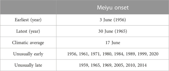
The standardization of the Meiyu onset date, the duration of the Meiyu period, and the interannual variation of the amount of rainfall during Meiyu in the Jiangsu Province from 1954 to 2020 (the figure of Anhui Province is omitted) are shown in Figure 1. There are significant interannual variations in the onset date of Meiyu, the duration of the Meiyu period, and the amount of rainfall during Meiyu in the Jianghuai region, and there is a significant correlation between the onset date of Meiyu, the duration of the Meiyu period, and the amount of rainfall during Meiyu. The correlation coefficients of the onset date of Meiyu and the duration of the Meiyu period in Anhui and Jiangsu are −0.47 and −0.53, respectively. The correlation coefficients of the onset date of Meiyu and the amount of rainfall during Meiyu are −0.24 and −0.30, respectively. Thus, the duration of the Meiyu period is usually longer and the amount of rainfall during Meiyu is generally greater when the onset date of Meiyu is early, so it can be seen that early and late Meiyu start dates have greater influence on the duration of the Meiyu period and the amount of rainfall during Meiyu in that year, especially in years when the onset date of Meiyu is unusually early and late, which is a key factor in the ruling of “extreme Meiyu.” At the same time, it can be found that the correlation between the start date of Meiyu and the duration of Meiyu is higher than its correlation with the amount of rainfall duringMeiyu, mainly because the early onset of Meiyu generally causes the end of Meiyu rain to occur later, and the amount of rainfall during Meiyu rain is related to the precipitation characteristics during the Meiyu period. Therefore, the analysis of the anomalous characteristics of Meiyu is important for the prediction of the Meiyu onset date. Taking 0.9 times standard deviation as the standard, the year when the two provinces’ Meiyu onset days were less than 0.9 times standard deviation was selected as the early year, and the year when the two provinces’ Meiyu onset days are more than 0.9 times standard deviation was selected as the late year of Meiyu onset. See Table 1 for abnormal years. The average onset date of Meiyu in the last 67 years in Jiangsu and Anhui was June 17, and the average end date was July 12. Among them, the earliest start date was June 3 (1956) and the latest was June 30 (1965), with a difference of 27 days between the earliest and latest entry dates. This shows that the onset date varies significantly each year. According to the statistics, early and late years of Meiyu onset are 8 and 6 years, respectively.
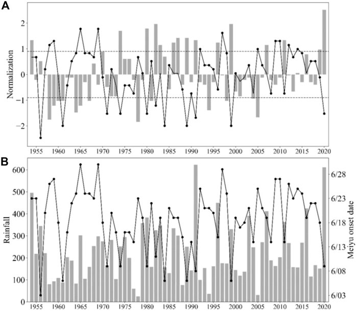
FIGURE 1. (A) Standardized time series of the onset date of Meiyu and the duration of Meiyu (the dotted line represents 0.9 times the standard deviation) in Jiangsu from 1954 to 2020 (B) Rainfall during Meiyu period and the onset date of Meiyu (The bar represents the duration of Meiyu and rainfall during Meiyu, and the broken line represents the onset date of Meiyu).
4 The relationship between the Meiyu start date and key weather systems
Summer wind activity in East Asia has a significant influence on the interannual variation of Meiyu. Different levels of circulation systems change significantly before and after the onset and end of Meiyu, such as the northward enhancement of South Asian high pressure and the northward jump of subtropical high pressure; accompanied by the stabilization and maintenance of the low-level jet and the formation of the Meiyu bands, this is a comprehensive reflection of the multi-scale weather systems. Therefore, different levels of weather systems play key roles in the formation of the rainy season, and changes in these systems determine the beginning and end of the rainy season.
4.1 The influence of the upper tropospheric South Asia High on Meiyu anomaly
The main influence system of the upper troposphere for Meiyu is South Asian high pressure, located in southern Asia, which is a strong and stable center of atmospheric activity and is an important part of the Meiyu weather system. The time, area, and intensity of South Asian high pressure starting to jump north and east in summer are closely related to the time of Meiyu onset in China (Liu et al., 2007). Figure 2 displays the analysis of the 200 hPa height occasion at different times of Meiyu; it shows that on June 5, the west ring of South Asian high pressure in the early Meiyu year was further west and slightly further north compared with climatic average years and the average late year, indicating that South Asian high pressure was established in the early Meiyu year and moved northward earlier, but its east ring does not show a strong advantage. On June 17, South Asian high pressure in the early Meiyu onset year was further north compared with the climatic average year and the average late year, and the east ring, in particular, was more pronounced. The position of the ridge of South Asian high pressure was close to that of -climatic average years and the late year, the position of the eastern extension of South Asian high pressure was close to that during climatic average years and the early year, and the ridge of South Asian high pressure in climatic average years and the late year was further north and east compared with June 5. On June 28, there was little difference between the position of the ridge line of South Asia high pressure in the early year, climatic average years, and the late year, indicating that Meiyuonset occurred at this time in each of the years. The changes and differences in the positions of South Asian high pressure on the anomalous and average onset days indicate that South Asian high pressure has a close relationship with the beginning and the progress of Meiyu, and the early and late jump of inSouth Asian high pressure to the north affects the early and late start of Meiyu.
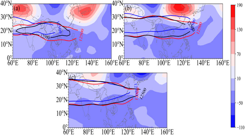
FIGURE 2. Comparative analysis of 200 hPa geopotential height (A). June 5th, (B). June 17th, (C). June 28th, unit: gpm) (Shaded area: the difference between early years and late years, contour: South Asia High (12500 gpm), blue: early years, red: late years, black: climatic average).
Another difference between the early and late years is that 200 hPa height fields also have obvious features and differences at certain times, the most obvious being that between June 5 and 17 on the north side of the high pressure in South Asia, distribution is "+-+", the Iranian plateau and the vicinity of Japan show a significant positive distribution, and the rest of the areas have negative distribution. The positive center on June 17 in the Iranian plateau decreased compared with the central value on June 5, and the positive center on the island of Japan increased compared with the 5th, and the center moved westward to the north China plain area. By June 28, there was no obvious positive or negative zone between the two height differences, and the situation was already relatively close in different years. Therefore, the difference between the early and late 200 hPa height fields is mainly manifested in early and mid-June, and the early height field near Japan is strongly correlated with the early onset of Meiyu, which is indicative of the early arrival of Meiyu.
The East Asian subtropical westerly rapid is a high-value wind speed zone located in north of the South Asian high pressure. Generally speaking, the time of the second northward jump of the westerly jet stream is closely related to the time of Meiyu onset in Jianghuai (Li et al., 2004). This article presents a synthetic analysis of the subtropical westerly jet stream in the years of early and late Meiyu onset. As shown in Figure 3, in the early onset year (Figure 3A), the center of the westerly rapid and the climatic mean state were close to each other before June 4, but after June 4, there was an obvious northward jump, and the rapid axis jump from 34°N to 38°N was obviously further north than the climatic mean state of the westerly rapid, which corresponded to the early start of the Meiyu in Jianghuai and Huaihua. In the late onset year (Figure 3B), the position of the westerly rapids from early to mid-June was stable at nearly 35°N, which was close to the climatic average position, and the wind speed of the rapids axis was slightly lower than that in the early onset year, with the central wind speed about 35 m/s. In late June, the westerly rapids axis jumped significantly northward, which corresponded to the late onset date. Therefore, the differences in the distribution of 200 hPa latitudinal winds between the early year, climatic average years, and the late year are obvious, fully reflecting the close relationship between the westerly rapids and the early and late onset of Meiyu.
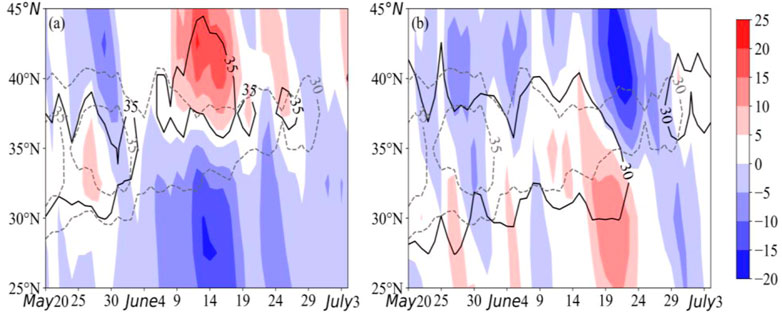
FIGURE 3. East Asia 110°-120°E average of 200 hPa zonal wind anomaly (unit: m/s) time-latitude cross sections in abnormal years of Meiyu onset (A): early years (B): late years The shaded area is the anomaly, and the dashed (solid) line represents the 30 m/s, 35 m/s contour of the climatic average in abnormal years.
The differences between South Asian high pressure and the westerly jet stream in the upper troposphere in the abnormal Meiyu onset year show that before the onset of Meiyu in the Jianghuai region, the upper East Asian summer wind circulation system underwent a rapid adjustment, with the southern high pressure gradually pushing northward, strengthening the center and increasing the area; the westerly jet stream took a second jump northward, from 34–35°N to 38–40°N, and maintained its position steadily or gradually moved northward. In general, in early Meiyu onset years, high pressure in South Asia is north-westerly and the westerly rush adjusts northward earlier, while the opposite is true of late Meiyu onset years.
4.2 The influence of mid-level subtropical high pressure on Meiyu anomaly
The 500 hPa height field is representative of the mid-tropospheric circulation system, and the main object of study is the large-scale circulation situation and the characteristics of the western Pacific sub-high. The analysis of the 500 hPa height field at different times in anomalous years (Figure 4) shows that on June 5, in early Meiyu onset years, the blockage in the middle and high latitudes of Europe and Asia is obvious, the positive height leveling area is located in the Ural Mountains and the East Siberian mountains, and the negative leveling area is located from the West Siberian plain to the Central Siberian plateau; the position of the sub-high is further west and north than the climatic average position, but the intensity is weaker than in climatic average years (Figure 4A). On June 17, the circulation situation in the middle and high latitudes of Eurasia still maintained an obvious double blocking high pressure, and the positive height deviation level located in the Ural Mountains was further strengthened, the ridge position and westward extension of the ridge point of the sub-high was close to that in climatic average years, and the intensity was less than in climatic average years (Figure 4B). On June 28, the blockage of the circulation in the middle and high latitudes of Eurasia weakened, the flat westerly zone was dominated by the circulation, and the position of the sub-high was close to the climatic average position (Figure 4C). In summary, the early westward extension of the sub-high’s northward jump is conducive to the early onset of Meiyu in the Jianghuai and Huaihua areas. In addition, the early onset of Meiyu shows a clear blockage of high-latitude circulation at different times in June, while mid-latitude circulation is flatter and straighter, and the sub-high maintains a longer period of stability and less movement.
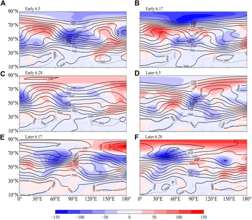
FIGURE 4. The characteristics of the 500 hPa geopotential height (unit: gpm) in the early and late years of the Meiyu onset date in the Yangtze-Huaiher River Basin (Shaded area: anomaly, black solid line: height field, gray dotted line: climatic average position of subtropical high). (A): June 5th in early years (B): June 17th in early years (C): June 28th in early years (D): June 5th in later years (E): June 17th in later years (F): June 28th in later years.
The situation surrounding circulation in the middle troposphere and the characteristics of the western Pacific subsurface are significantly different to those in the early year; the position of the sub-high in the late year, on June 5 (Figure 4D), is significantly more easterly and southerly than the climatic average position, and the latitudinal circulation is dominant at high latitudes, and the coastal trough is controlled in the Jianghuai region, which is not conducive to the onset of Meiyu in the Jianghuai region. On June 17, the position and intensity of the sub-high (Figure 4E) were close to those in climatic average years, but the height field in the middle and high latitudes of Eurasia became obviously negative, and the coastal trough was still controlling the Jianghuai area. By June 28 (Figure 4F), the sub-high was close to normal, and the coastal trough in the JH region disappeared and turned into a flatter trough fluctuation type. The circulation situation is conducive to the onset of Meiyu.
The blockage is a prerequisite for the onset of Meiyu as it is conducive to the accumulation of cold air and provides favorable cold air transport for the occurrence of heavy rainfall during the Meiyu period. The characteristics of the western Pacific sub-high are also significant in the onset of Meiyu in Jianghuai and Huaihua, and it, therefore, deserves further discussion. The study shows that the time of the second northward jump of the subsurface corresponds with the end of Meiyu in Jianghuai (Liu et al., 2013). As shown in Figure 5, the ridge of the sub-high in the early year (Figure 5A) was significantly further north than in climatic average years and it was generally maintained north of 19°N. Between June 25 and June 29, the sub-high suddenly jumped north, and the ridge position was adjusted from 19°N to 23°N (Figure 5B), which was the same time as the northward jump of the upper jet at this time in the late Meiyu onset year in the Jianghuai region. It can be seen that the position and time of the northward jump of the sub-high ridge have a strong relationship with the start of Meiyu in the Jianghuai region. The sub-high ridge jumps northward early and stably maintains a more northerly position in the year of early Meiyu onset, while the sub-high ridge is more southerly than the climatic average position in the year of abnormally late Meiyu onset and surpasses 20°N later.
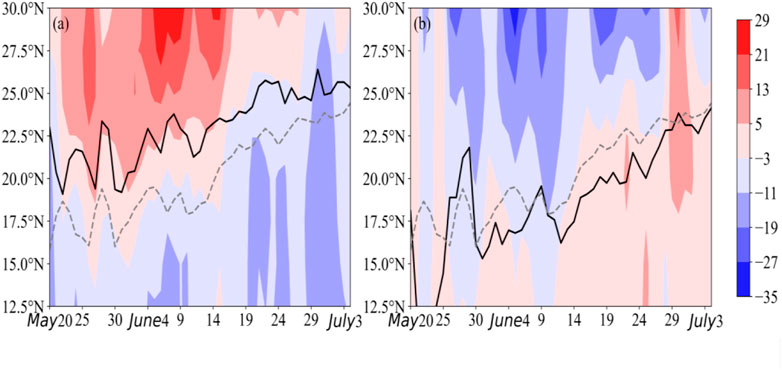
FIGURE 5. 110°-140°E average of 500 hPa geopotential height time-latitude cross sections in the early and late years of Meiyu onset (A): early years (B): late years (The shaded area is the anomaly, and the dashed (solid) line represents the climatic average position (abnormal year) of the subtropical high ridgeline).
4.3 Influence of the low-level jet on the early and late onset of Meiyu
The trans-equatorial flow in the low-level system, the early and late summer wind outbreak in the South China Sea, and the strength of the low-level rapids all reflect the water vapor supply, which has a significant influence on the early and late onset of Meiyu and the amount of precipitation in the Jianghuai region of China. According to Li Chongyin (Li and Wu, 2002), Ding Yihui (Ding et al., 2007), and others, the Bay of Bengal-Central Indian Peninsula-South China Sea region is the main water vapor supply zone during the Meiyu period in China, and the time of the summer wind outbreak in the South China Sea, the time of the establishment of the Somali equator crossing, and the date of Meiyu onset are closely related. Figure 6 shows the comparison of the 850 hPa wind field at different stages of the years of the Meiyu onset anomaly. As shown in the figure, on June 5 of the early year (Figure 6A), there was a southwest wind anomaly in the Somali Basin, a significant westerly wind anomaly in the water vapor conveyor belt of the Bay of Bengal-Central Indian Peninsula-South China Sea, and significant anticyclonic anomalous circulation over the western Pacific Ocean off the eastern coast of China. In the late year (Figure 6D), there was a northwesterly wind anomaly on the sea surface of the southern coast of China and cyclonic abnormal circulation on the sea surface of the eastern coast; thus, the outbreak of trans-equatorial flow in the early year was earlier than in the late year, and the anticyclone intensity east of the Philippines was stronger than in the late year. The supply of low-level water vapor was more abundant on June 5 in the early year, which was favorable to Meiyu onset. On June 17 (Figure 6B), when Meiyu began, the southwesterly low-level jet in Guangxi and the middle and lower reaches of the Yangtze River were unusually strong, which was conducive to the transport of water vapor and the maintenance of Meiyu in the Jianghuai region. The low-level wind field from the Bay of Bengal to the Indian Peninsula and the South China Sea is controlled by anticyclones, and the west of Jianghuai is controlled by an abnormally strong northwesterly wind field. The low-level circulation configuration is still unfavorable for water vapor transportation to the Jianghuai area, which, in turn, is unfavorable to the onset of Meiyu in the Jianghuai area. On June 28, in both abnormally early Meiyu years and abnormally late Meiyu years, there are no obvious system and element anomalies in low-level circulation, which means that both are closer to the average-climate situation.
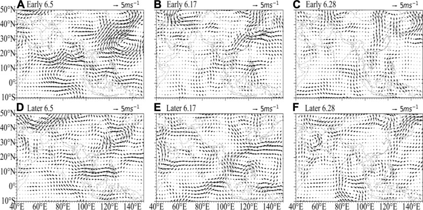
FIGURE 6. 850 hPa wind field (unit: m/s) anomalies in the early years (A), (B), (C) and late years (D), (E), (F) of the Yangtze-Huaihe River (A), (D): June 5th; (B), (E): June 17th; (C), (F): June 28th).
The location, duration, and high humidity zone of the low-level rapids determine the time of the onset of Meiyu and the duration of the Meiyu period, and the change of the 850 hPa high relative humidity zone is an indicator of the distribution of water vapor, and is a reference basis on which the start and end of Meiyu can be determined. In the early year (Figure 7A), from late May to early June, the high relative humidity zone was stable at nearly 26°N. The low-level jet was enhanced from early June, the southwesterly wind was obviously strengthened, and a steady stream of water vapor was transported to the Jianghuai region. The high relative humidity zone was pushed northward to around 28–32°N on June 7, when Meiyu started in Jianghuai, and a continuous high humidity and rapid convergence zone appeared in the region. In the late year (Figure 7B), before June 20, the low-level jet in the range of 110°–120°E was not significantly enhanced, the southwesterly wind was obviously weak, and the high relative humidity zone was located around 25–28°N until late June. When the low-level rapids appeared significantly northerly, the high humidity zone was pushed further north to around 28–30°N, and Meiyu began in the Jianghuai and Huaihua areas.
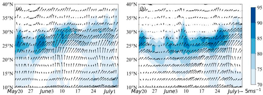
FIGURE 7. 110°-120°E average of 850 hPa relative humidity (shadow, unit: %) and wind field (unit: m/s) time-latitude cross sections in the early and late years of Meiyu onset (A): early years (B): late years.
From the above analysis, it can be concluded that the strength of the trans-equatorial jet stream—especially the Somali rapids, the early and late outbreak of the South China Sea summer winds, and the location and intensity of the Philippine anticyclone—has important effects on the levels of water vapor in the Jianghuai region. When the Somali rapids and the South China Sea summer winds break out early, and when the intensity of the Philippine anticyclone is greater, water vapor in the Jianghuai region of China is more abundant, which is conducive to the earlier onset of Meiyu. Meanwhile, the distribution of low level water vapor and the northward jump of low-level rapids also have a strong correspondence with the time of Meiyu onset.
5 Precursor signal of early and late Meiyu in the JAC region
In addition to the internal dynamic processes, atmospheric circulation anomalies are also influenced by external forcing signals. For China, SST, snow cover, and soil moisture are the main factors considered, and this paper focuses on the influence of SST anomalies on the day of Meiyu onset in the Jianghuai region. As shown in Figure 8A, the day of Meiyu onset in the Jianghuai region is significantly negatively correlated with the tropical Indian Ocean and the central-eastern equatorial Pacific Ocean and significantly positively correlated with the north Pacific Ocean in the previous autumn (September-November). The correlation between the day of Meiyu onset and the SST in the previous winter (December-February) (Figure 8B) has changed significantly compared with the spring, with a negative correlation in the ocean north of the equator and a positive correlation in the ocean south of the equator; the area with the strongest correlation is the Arabian Sea-Gulf of Bengal—South China Sea area, with a significant negative correlation. The correlation distribution between the day of Meiyu onset and pre-spring (March-May) SSTs (Figure 8C) is almost opposite to that in autumn, with a positive correlation in the Indian Ocean and South Pacific regions and a negative correlation in the North Pacific region.

FIGURE 8. The distribution of correlation coefficients between the sea surface temperature in the early autumn (A), winter (B), and spring (C), and the Meiyu onset date from 1954 to 2020 (the dotted area passed the 99% T-test).
The Indian Ocean and Pacific Ocean SST anomalies mainly affect the East Asian subtropical summer wind, which, in turn, affects summer precipitation in the Jianghuai region (Li et al., 2007). The Indian Ocean transports a large amount of warm and humid water vapor to China, which can significantly affect precipitation in the middle and lower reaches of the Yangtze River. In the following spring and summer, the ENSO signal is retained through a “discharge” effect, which causes the western Pacific subsurface to maintain an abnormally strong state, favoring the weak Indian summer winds and high summer precipitation in the middle and lower reaches of the Yangtze River (Wang et al., 2000; Yang et al., 2008). Therefore, the key SST zones in the Indian and Pacific Oceans are selected for analysis of their influence on the day of Meiyu onset.
From the analysis of Figure 9, it is clear that early and late Meiyu onset dates are best correlated with the Indian Ocean and the eastern Pacific Ocean. The mean SSTA of the (10°S- 10°N, 60°- 100°E) region is selected to represent the equatorial Indian Ocean region (Zone I); the mean SSTA of the (15°-25°N, 60°-130°E) region represents the Bay of Bengal—South Sea region (Zone II); the (5°S-20°S, 150°-80°W) region and the (0°-20°S, 120°-80°W) region represent eastern equatorial Pacific region (Zones III and IV). The correlation coefficients of autumn, winter, and spring SSTs in key zones with the characteristic parameters of the western Pacific subtropical high pressure in June and the day of Meiyu onset are further analyzed, and the data of the more strongly correlated parts are shown in Table 2. As can be seen in Table 2, the correlation between autumn SST and subtropical high parameters in zone I is not strong, but there is a strong negative correlation with the day of Meiyu onset; this means that the higher the SST in Zone I in autumn, the earlier the day of Meiyu onset in the Jianghuai area in the following year. Although the correlation coefficient of winter SST in Zone I with the day of Meiyu onset is small, it is positively correlated with the high intensity and area of the sub-high and negatively correlated with the westward extension of the sub-high ridge; this means that the higher the SST in this area in winter, the higher the intensity and area of the sub-high in June of the following year and the more southerly the position of the sub-high. Therefore, the winter SST in Zone I has a significant influence on the western Pacific sub-high, but because the intensity and area are positively correlated and the position is negatively correlated, it is generally not strongly correlated with the day of Meiyu onset. In the correlation coefficients of SSTs in key areas (table omitted), the correlation between spring SSTs in Zone I and winter SSTs in Zone II is stronger, and they are negatively and positively correlated with the ridge of the sub-high and positively and negatively correlated with the day of Meiyu onset respectively; this means that the lower the spring SSTs in Zone I, the higher the winter SSTs in Zone II and the more northerly the position of the sub-high in June of the following year. It also results in the transport of water vapor to the middle and lower reaches of the Yangtze River in China being more adequate than the same period and the day of Meiyu onset being earlier in the Jianghuai area. The SSTs of Zone III and Zone IV are significantly correlated, and the correlation between them and the parameters of the sub-high and the day of Meiyu onset is also consistent, both of them are positively correlated with the sub-high ridge and negatively correlated with the day of Meiyu onset in autumn and negatively correlated with the sub-high ridge and positively correlated with the day of Meiyu onset in spring. This indicates that the higher the SST in the eastern equatorial Pacific in autumn, the lower the SST in the following spring, and the more northerly the position of the sub-high in June, the earlier the onset of Meiyu in the Jianghuai region. Thus, SST is an important precursor of early and late Meiyu onset in the Jianghuai region.
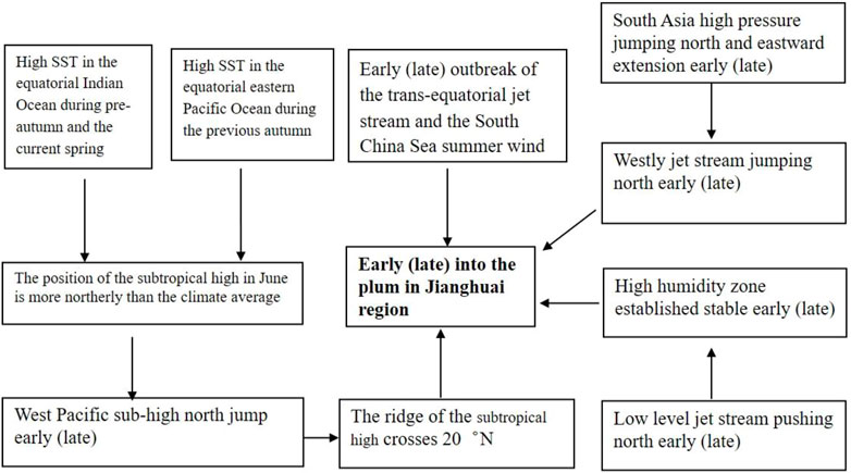
FIGURE 9. Conceptual diagram of the key influence system for the Meiyu onset date over the Yangtze-Huaihe River Basin.

TABLE 2. Correlation coefficients between partial seasonal SST anomalies in Zone I (Equatorial Indian Ocean), Zone II (Bay of Bengal-South China Sea), Zone III, and Zone IV (Eastern Pacific) from 1954 to 2020; the Western Pacific subtropical high in June of the following year; and the Meiyu onset date.
6 Conclusion and discussion
The prediction of the beginning and end of Meiyu has always been the focus of forecasters. The onset of Meiyu in the Yangtze-Huaihe River basin is closely related to changes in different levels of weather systems and their advance to the north; in particular, being able to determine what is an “abnormal year” plays a key role and can provide scientific and technical support to the government, agriculture, and water conservancy as well as supporting other decision-making. In this paper, we analyze the characteristics of the changes in the key influencing systems of anomalous Meiyu onset years in Jiangsu and Anhui in the past 67 years using data on Meiyu, combined with NCEP/NCAR reanalysis data, and provide reference indicators and signals for Meiyu forecasting from different weather systems and SST. The results are as follows.
1) In the past 67°years, the time of Meiyu onset in the Jianghuai region has varied significantly inter-annually. Meiyu start time, duration, and total rainfall have a strong correlation; generally, early Meiyu leads to its longer duration and greater rainfall. The time of the northward movement of South Asian high pressure, the northward jump of the westerly rapids, the northward jump of the paramount, the high-value area of the low-level relative humidity, and the northward movement of the low-level rapids are closely related to the time of Meiyu onset.
2) In years with unusually early Meiyu onset, the South Asian high pressure and the western Pacific sub-high jumped significantly north from late May to early June, and the westerly rapids jumped from 34–35°N to 38–40°N and remained stable at higher latitudes and significantly further north compared with its climatic average position. The sub-high was unusually strong at the beginning of June, and the position of the ridge of the sub-high was significantly further north and surpassed 20°N between late May and early June compared with the climatic average position, and the time of the enhanced northward push of the low-level jet was also significantly early. In the late year, the westerly jet and the ridge of the sub-high were slightly further south than the climatic average position from early June to late June and did not jump significantly north until late June.
3) SST anomaly in the early stages is an important external forcing factor affecting the early and late onset of Meiyu, among which, the impact of SST anomaly in the Indian Ocean and the Pacific Ocean is the most significant. When the SST of the equatorial Indian Ocean is high in the autumn, Meiyu starts early in the Jianghuai region. When the SST of the equatorial Indian Ocean is high in the spring, the SST of the Bay of Bengal-South China Sea is usually low in winter, and the position of the sub-high in June of the following year is further north compared with the climatic average position, which leads to Meiyu starting early in the Jianghuai region. When the SST of the eastern equatorial Pacific Ocean is high in the autumn, the SST of the region is often low in the spring of the following year, and the position of the sub-high in June is further north, so Meiyu starts early in the Jianghuai region. When the SST of the eastern equatorial Pacific region is high in the early autumn, the SST of the region is often low in the following spring, and the position of the sub-high is further north, so Meiyu starts early in the Jianghuai region.
4) The key systems and pre-SSTs that affect the date of Meiyu onset in the Yangtze-Huaihe River basin are combined in Figure 9 to establish the conceptual map of key influencing systems for early and late Meiyu onset in the Yangtze-Huaihe River basin, respectively, to provide ideas for Meiyu forecasting.
This study mainly focuses on the climatic characteristics and influence systems of anomalies in the start and end times of Meiyu in the Jianghuai region, but there are many issues, particularly the influence of the precursor, SST on the Meiyu onset date, which need to be further investigated.
Data availability statement
Publicly available datasets were analyzed in this study. This data can be found here: data.cma.cn.
Author contributions
XJ completed the analysis of the climatic characteristics of the Meiyu onsetdata in Jianghuai region, YM completed the analysis of the characteristics of the weather system, ML completed the analysis of the sea temperature signal, and SZ completed the data calculation.
Funding
This work is sponsored by the Yangtze River Basin Meteorological Open Fund (CJLY 2022Y02) and the Key Projects of the Jiangsu Meteorological Bureau (KZ202101).
Conflict of interest
The authors declare that the research was conducted in the absence of any commercial or financial relationships that could be construed as a potential conflict of interest.
Publisher’s note
All claims expressed in this article are solely those of the authors and do not necessarily represent those of their affiliated organizations, or those of the publisher, the editors and the reviewers. Any product that may be evaluated in this article, or claim that may be made by its manufacturer, is not guaranteed or endorsed by the publisher.
References
Chen, B., Jiang, Y., Li, D., and Tang, Y. (2020). Response of Meiyu in Jianghuai region on the process of East Asian subtropical summer monsoon and sea surface temperature anomaly. J. Meteorological Sci. 40 (5), 669–678. doi:10.3969/2020jms.0072
Choi, J.-W., Kim, H.-D., and Wang, B. (2020). Interdecadal variation of Changma (Korean summer monsoon rainy season) retreat date in Korea. Int. J. Climatol. 40 (3), 1348–1360. doi:10.1002/joc.6272
Ding, Y., Liu, J., Sun, Y., Liu, Y., He, J., and Song, Y. (2007). A study of the synoptic-climatology of the Meiyu system in East Asia. Chin. J. Atmos. Sci. 31 (6), 1082–1101. doi:10.3878/j.issn.1006-9895.2007.06.05
Huang, Q., Wang, L., Li, Y., and He, J. (2012). Determination of the onset and ending of regional Meiyu over Yangtze-Huaihe River valley and its characteristics. J. Trop. Meteorology 28 (5), 749–756. doi:10.3969/j.issn.1004-4965.2012.05.015
Li, C., Han, G., Liu, M., Sun, H., and Zhou, L. (2015). Relationship between East Asia jet anomaly and Meiyu onset over yangtze-HuaiheRiver valley. J. Meteorological Sci. 35 (2), 176–182. doi:10.3969/2014jms.0043
Li, C., Wang, Z., Lin, Z., and Cho, H. (2004). The relationship between east Asian summer monsoon activity and northward jump of the upper westerly jet location. Chin. J. Atmos. Sci. 28 (5), 641–658. doi:10.3878/j.issn.1006-9895.2004.05.01
Li, C., and Wu, J. (2002). Important role of the somalian cross-equator flow in the onset of the South China Sea summer monsoon. Atmos. Sci. 26 (2), 185–192. doi:10.3878/j.issn.1006-9895.2002.02.04
Li, Y., Wang, Y., and W, D. (2007). Effects of anomalous SST in tropical Indian Ocean and Pacific Ocean on next june rainfall over the Yangtze River Basin and area south of the basin. Acta Meteorol. 65 (3), 393–405. doi:10.11676/qxxb2007.037
Liu, M., Hu, L., and Pu, M. (2007). Study on change of South Asia high and response of other weather system during summer. Sci. Meteorol. Sin. 27 (3), 294–301. doi:10.3969/j.issn.1009-0827.2007.03.009
Liu, Y., Hong, J., Liu, C., and Zhang, P. (2013). Meiyu flooding of Huaihe River valley and anomaly of seasonal variation of subtropical anticyclone over the Western Pacific. Chin. J. Atmos. Sci. 37 (2), 439–450. doi:10.3878/j.issn.1006-9895.2012.12.313
Luo, L., Xu, M., and He, D. (2019). Interdecadal characteristics of summer precipitation over HuaiheRiver Basin and the associated atmospheric circulation anomalies since 2000. J. Arid Meteorology 37 (4), 540–549. doi:10.11755/j.issn.1006-7639(2019)-04-0540
Sun, S., and Li, D. (2019). Morphological variation of the Western Pacific subtropical high and its possible thermodynamic causes under the background of climate warming. Acta Meteorol. Sin. 77 (1), 100–110. CNKI:SUN:QXXB.0.2019-01-008.
Takaya, Y., Ishikawa, I., Kobayashi, C., Endo, H., and Ose, T. (2020). Enhanced meiyu-baiu rainfall in early summer 2020: Aftermath of the 2019 super IOD event. Geophys. Res. Lett. 47 (22), 090671. doi:10.1029/2020GL090671
Tang, Y., and Li, D. (2020). The relationship between the Meiyu in the Yangtze-Huaihe Region and the variation of the East Asiansubtropical summer monsoon process. J. Meteorological Sci. 40 (2), 169–179. CNKI:SUN:QXKX.0.2020-02-003.
Wang, B., Wu, R., and Fu, X. (2000). Pacific-East asian teleconnection: How does ENSO affect East Asian climate. J. Clim. 13 (9), 1517–1536. doi:10.1175/1520-0442(2000)013<1517:PEATHD>2.0.CO;2
Xu, B., Chen, H., Gao, C., Zeng, G., and Huang, Q. (2021). Abnormal change in spring snowmelt over Eurasia and its linkage to the East Asian summer monsoon:The Hydrological effect of snow cover. Front. Earth Sci. 8 (594656). doi:10.3389/feart.2020.594656
Yang, M., Ding, Y., Li, W., and Mao, H. (2008). The leanding mode of Indian Ocean SST and its impacts on asian summer monsoon. Acta Meteorol. Sin. 22 (1), 31–41. CNKI:SUN:QXXW.0.2008-01-004.
Zhao, J., Chen, L., and Wang, D. (2018). Characteristics and causes analysis of abnormal Meiyu in China in 2016. Chin. J. Atmos. Sci. 42 (5), 1055–1066. doi:10.3878/j.issn.1006-9895.1708.17170
Zhao, J., Wang, A., and Wang, H. (2021). Soil moisture memory and its relationship with precipitation characteristics in China region. Chin. J. Atmos. Sci. 45 (4), 799–818. doi:10.3878/j.issn.1006-9895.2007.20149
Keywords: Meiyu over the Yangtze-Huaihe River Basin, Meiyu onset date, abnormal circulation, subtropical high, South Asia high
Citation: Jin X, Ma Y, Liu M and Zhong S (2023) Evolution characteristics of impact weather system and SST signals during years of anomalous Meiyu onset over the Yangtze-Huaihe River Basin. Front. Earth Sci. 11:1110898. doi: 10.3389/feart.2023.1110898
Received: 29 November 2022; Accepted: 10 January 2023;
Published: 03 February 2023.
Edited by:
Yunheng Wang, University of Oklahoma, United StatesReviewed by:
Omid Memarian Sorkhabi, University of Isfahan, IranJunhu Zhao, National Climate Center, China
Copyright © 2023 Jin, Ma, Liu and Zhong. This is an open-access article distributed under the terms of the Creative Commons Attribution License (CC BY). The use, distribution or reproduction in other forums is permitted, provided the original author(s) and the copyright owner(s) are credited and that the original publication in this journal is cited, in accordance with accepted academic practice. No use, distribution or reproduction is permitted which does not comply with these terms.
*Correspondence: Yutong Ma, MTAzNDQ3Mjc3M0BxcS5jb20=; Mei Liu, bG1rZXJyeUAxNjMuY29t
 Xiaoxia Jin
 Yutong Ma2*
 Mei Liu
 Shanshan Zhong