 Yongguo Zhang1
 Yanzhao Yang
- 1Department of Surveying and Mapping, College of Mining Engineering, Taiyuan University of Technology, Taiyuan, China
- 2Institute of Geographic Sciences and Natural Resources Research, Chinese Academy of Sciences, Beijing, China
The main purpose of this study is to analyze the main influencing factors of the landslide in the coal mine area and, on this basis, establish the sensitivity zoning model of the landslide. Considering the difficulty to obtain the expected results by using machine learning under the condition of lacking data, the typical landslide is used as the data basis, that is, the Fenxi coal mine and Xishan Bujiu coal mine are selected as the coal mining landslide points. Various factors, such as goaf, land subsidence, slope structure, formation lithology, and various indicators are used as input data sources, and artificial neural network (ANN) datasets are used for training to establish a pre-training model. Using the pre-training model, the mining landslide sensitivity evaluation model based on transfer learning is established. In order to demonstrate the performance of transfer learning more intuitively, the neural network is introduced to evaluate the evaluation model. The test results show that transfer learning can achieve a transfer effect higher than 0.95, and the regional distributions of highest landslide sensitivity calculated based on self-transfer learning, direct push transfer learning, and inductive transfer learning are 31.33, 35.50, and 33.75%, respectively, which further deduced that inductive transfer learning can be used for evaluating an LSP model.
1 Introduction
As shown in previous studies, landslide sensitivity assessment is an effective solution. Zhong and Hu (2013) believed that spatial cognition is an essential information transformation process. How to acquire spatial location information, recognize and reconstruct the information, and use the information to make decisions and guide external actions is the main work and content of spatial cognition research and is an important field of cognitive science research. The essence of the scene is to recognize the physical world (Ghorbanzadeh et al., 2018). The analysis of the scene of landslide disaster is to identify the scene that is not felt. The landslide susceptibility evaluation focuses on the study of landslide influencing factors in highly susceptible areas so as to guide disaster prevention and mitigation and various planning methods (Piralilou et al., 2019). Landslide sensitivity analysis is a hot and difficult topic in landslide research (Feizizadeh and Blaschke, 2014). By analyzing the relationship between landslide influencing factors and landslide in the region, the distribution law of landslide can be determined, and the spatial distribution and occurrence probability of the existing or potential landslide can be analyzed qualitatively or quantitatively (Shi et al., 2005; Liu et al., 2021; Zhang et al., 2022a; Zhan et al., 2022). The causes of landslides are complex, and the influencing factors include the basic factors causing landslides (topography and landform, stratigraphic lithology, geological structure, traffic, and water system) and the inducing factors (rainfall, earthquake, and human engineering activities). At present, the most commonly used landslide sensitivity analysis methods are knowledge-driven, including the fuzzy logic method, fuzzy comprehensive evaluation method, analytic hierarchy process, and expert system method. The second is the deterministic physical model. The deterministic coefficient (CF) model was proposed and improved by Shortliffe and Buchanan (1975) and Heckerman (2013). Tian et al. (2016) evaluated the geological disaster susceptibility of Guangdong Province based on the certainty coefficient (CF) model and LR model. Kang et al. (2011) analyzed the application of the deterministic model to evaluate the stability of hillslopes of loess gully areas. Montgomertry and Dietrich (1994) established SHALSTAB in the 1990s in the paper Application of Deterministic Models to Slope Stability Prediction in the Loess Gully Region. The model has been used to predict the loess area in Northwest China and the area in southeast China, where the seasonal rainfall significantly affects the area and shallow landslides are more developed. On the basis of the SHALSTAB model proposed by Pack et al. (1998), we studied the hydrological distribution model of DEM to construct a SINMAP model. The deterministic model is mainly applicable to the case where the landslide type is relatively simple and the basic physical properties of the study object are fairly uniform (Ghorbanzadeh et al., 2022a). Based on physical laws, this method can analyze the main factors, but it requires high parameters and is limited to small-scale regions. It is a data-driven type, mainly based on the theory of statistical analysis, including the amount of information analysis and support vector machine (SVM), random forests and artificial neural networks, multivariate statistical analysis method, and other data-driven methods, ensuring the accuracy of the calculation and analysis results through mathematical analysis and non-linear objective characteristics, but need various global spatial representations of good observation samples (Heleno et al., 2016). The failure to easily excavate the disaster mechanism of landslides leads to the problem of underfitting or overfitting of analysis results (Pham et al., 2020; Ma et al., 2021). This is in contradiction to the current objective situation, such as the large amount of observation data but little spatial and temporal information, high concealability of landslides, and incomplete collection of landslide catalog datasets. There are many research studies on data-driven landslide sensitivity. Influenced by the non-linear characteristics of landslides, many problems in landslide sensitivity evaluation, such as factor selection, parameter optimization, and model sample optimization, have not been systematically solved. The geographic information system and the advancement of artificial intelligence (AI) technology will promote the development of more efficient and accurate studies on the sensitivity of the landslide inventory, which makes the evaluation of contributing factor system more reasonable (Ghorbanzadeh et al., 2022b). More intelligent models are applied to landslide susceptibility, and all kinds of machine learning methods, including logistic, classification and regression tree (CART), SVM, and transfer learning, have been widely used (Huo et al., 2019; Ghorbanzadeh et al., 2022c; Shi et al., 2022; Wang et al., 2022). C5.0 decision tree, random forest, and support vector machine are used to partition landslide sensitivity and compare its performance in the coal mining area. The information quantity model is a statistical forecasting method based on information theory. It was proposed by Chinese scholars Yin and Zhu (2001). Based on ArcGIS spatial analysis, seven evaluation factors, namely, elevation, slope, lithology, slope structure, vegetation index, distance from the fault, and distance from the road of the study area, were obtained (Wen et al., 2022). After the information model was used to evaluate the susceptibility of landslide and collapse disasters, ArcGIS was further used. The statistical function of a GSI unit compares the information value of landslide and collapse susceptibility, selects a relatively larger information value as the final information value of the grid, and draws the comprehensive geological disaster susceptibility map of the study area, which is essentially the reflection of the integrated information atlas map based on the sensitivity of landslides and various factors. It is a relatively effective quantitative method for the regional scene expression of landslide disasters, most of which focuses on a single data-driven model. In recent years, the landslide sensitivity analysis method combining data-driven and knowledge-driven models has received a lot of attention to systematically analyze the causes and mechanisms of landslides (Yang et al., 2019). The regional landslide sensitivity assessment based on the deterministic coefficient combination model has been proposed. Zhu et al. (2021) proposed a fuzzy logic analysis method for regional landslide sensitivity constrained by spatial characteristics of environmental factors of landslide disaster, which is a classic example of combining knowledge-driven and data-driven models. There are few studies on combining data-driven and data-driven models. This paper makes a beneficial attempt on the transfer learning of mining landslide utilization based on the data-driven + data-driven model combined with previous studies.
In short, the core demand of geological disasters is to find out “where is the hidden danger” and “when is it likely to occur,” which is also the difficult problem and bottleneck that needs to be broken for the prevention and control of geological disasters. Despite the type of landslide scenario, the basic conditions for landslides remain the same, that is, slippery strata, weak structural plane, and empty surface. The occurrence of landslide is affected by many factors, and the influence degree of each factor is different for each landslide. It may be a key factor in this landslide, but it may be a minor factor in another landslide. Only by finding out the basic law and mechanism of the landslide can a reasonable landslide susceptibility model be established, and correct calculation and numerical simulation can be carried out. According to the previous research results and combined with the landslide disaster scene itself, generally speaking, we believe that in the control factors, topography often plays a decisive role in the formation of landslide disaster and is also a necessary condition for the formation of landslide, and stratigraphic lithology often provides a material basis for the formation of landslides. Geological structure plays a controlling role in it, and the inducing factor often causes and intensifies the occurrence of landslides. To screen out the main leading factors from the disaster environment and inducing factors under different regional conditions and determine the reasonable model, this paper has carried out a study on mining landslides based on transfer learning.
2 Research data
2.1 Study area
The Fenxi coal mine area is about 104.4 km from east to west and 71.2 km from north to south, with a total area of 4,332.1 km2 and a coal-bearing area of 3,513.282 km2. The mining area has complex geomorphic types. The study area spans the Luliang Mountains and Huoshan Mountain from east to west and the Fenhe Valley in the central and northern areas, with high terrain in the south and low terrain in the north (Yang et al., 2018). This region is located in the mid-latitude inland region, far from the ocean, less affected by water vapor, and has a large temperature difference between the day and night, which is a typical semi-arid continental climate (Neto et al., 2018). The study area is rich in mineral resources. In recent years, due to long-term excessive exploitation by humans, the balance of the terrain surface in this area has been seriously damaged, and a large number of mined-out areas have been formed underground. The landform of the Fenxi coal mine area is shown in Figure 1A, and the left of Figure 1A shows the magnified result of the pink area of the right of Figure 1A.
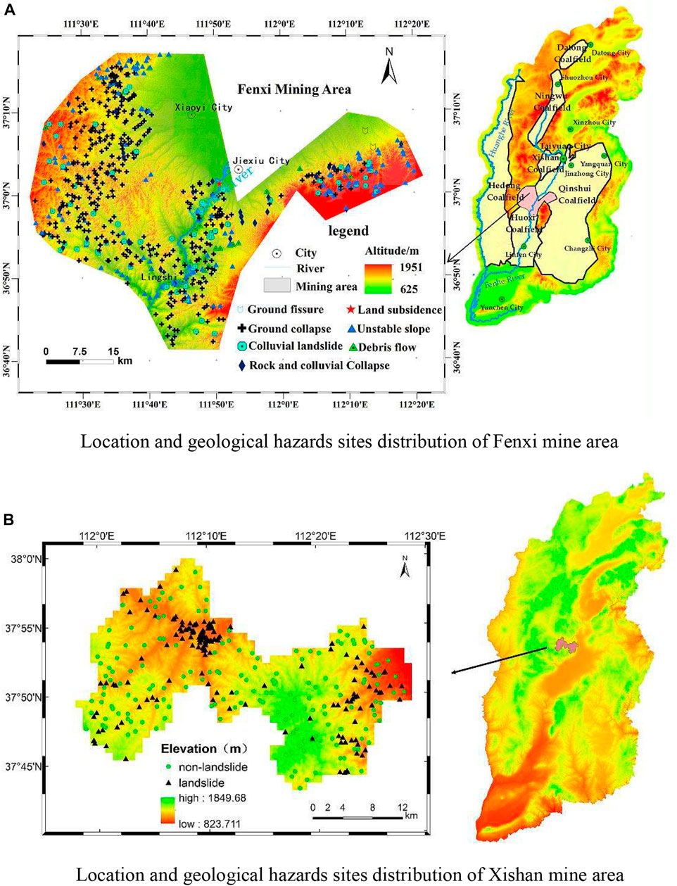
FIGURE 1. Location and distribution of geological hazard sites of the study area. (A) Location and geological hazards sites distribution of Fenxi mine area, (B) Location and geological hazards sites distribution of Xishan mine area.
Xishan Coal Power Co., Ltd. is an important backbone subsidiary of Shanxi Coking Coal Group Co., Ltd. The Jiukuang mining area of Xishan Coal Power Co., Ltd. is divided into two parts: Qianshan area and Gujiao area. The former mountain area lies in the east and is located in Taiyuan Wanberlin District; the ancient Jiaohe area in the northwest is located in the city of ancient Jiaohe. Qianshan mine has five pairs of mines, namely, Baijiazhuang Mining Co., Ltd., Duerping mine, Guandi mine, Dongqu mine, and Tunlan mine. Gujiao mine has jurisdiction over four mines, namely, Xiqu mine, Zhencheng bottom mine, Malan mine, and Ximing mine. Xigou mine also belongs to Xishan Coal Power; however, it is far away from other mines and cannot be compiled into a mining map. Therefore, only nine mines in the Xishan mining area are studied. The geographical coordinates of the Xishan mining area are 111°50′∼112°40′ east longitude and 37°50′∼38°10′north latitude. It is 68 km long from north to south and 36 km wide from east to west. The coal-bearing area is 1,800 km2. The nine mines in the headquarters are Guandi mine, Baijiazhuang mine, Duerping mine, Ximing mine, Malan mine, Xiqu mine, Zhencheng bottom mine, Dongqu mine, and Tunlan mine. Based on high-precision satellite and aerial image remote sensing and field investigation, the location, type, and basic geometric characteristics of 146 landslides in Jiujiu mine and the headquarters of the Xishan coal field were obtained. The landslide historical catalog database was established using GIS software. The landform of the Xishan coal mine area is shown in Figure 1B, and the left of Figure 1B is the magnified result of the dull-red area of the right of Figure 1B.
2.2 Data sources
Landslide geospatial datasets are the basis of landslide sensitivity analysis. The integrity and quality of the datasets directly affect the accurate reliability of landslide sensitivity assessment results. According to the classification and evaluation purpose, landslide susceptibility assessment geospatial datasets can be divided into historical landslide catalog and geographical environment, geological environment and disaster environment, ecological environment, and several aspects, including historical landslide catalog set by remote sensing and geological disasters, usually ZaiHaiDian landslide spatial distribution of the environmental monitoring center for data. The data include geological topographic map, road and water network data, and vegetation cover data as shown in Tables 1, 2.
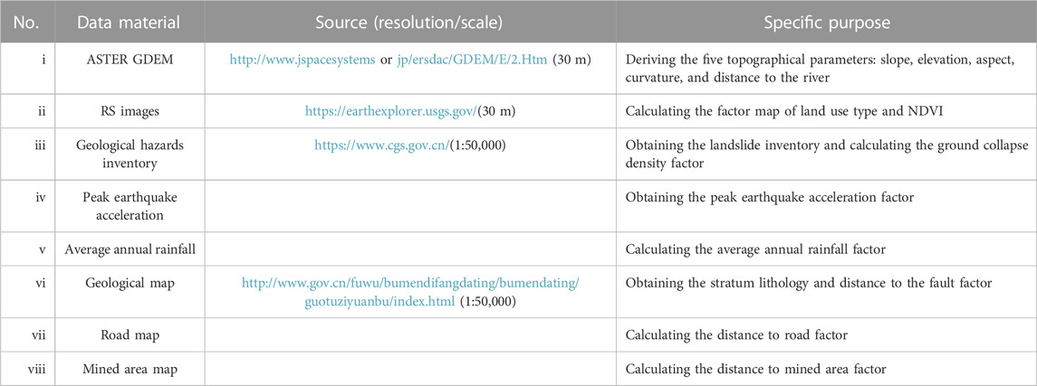
TABLE 1. Source and characteristic of Fenxi coal mine data materials.
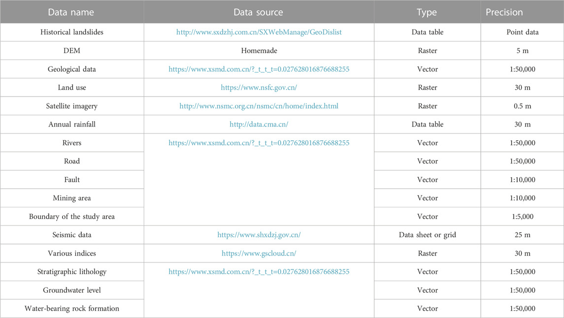
TABLE 2. Xishan’s main data and data sources.
2.3 Condition factors
Geological disasters destroy the ecological environment, and their occurrence is affected by various internal and external dynamics. On the basis of geological, topographic, and survey data from the study district, as well as existing expert experience (Chau et al., 2004; Peart et al., 2005; Domínguez-Cuesta et al., 2007; Xiang et al., 2010), selected influencing factors such as topography, geology, hydrology, land cover, and human engineering activities (Youssef and Pourghasemi, 2021) were used to explore the mechanism and characteristics of landslide disasters. Topographic factors are represented by elevation, slope, aspect, and curvature (plane and profile curvature). Geological structure factors include stratum lithology, distance from the fault, and peak acceleration. Hydrological factors include annual average rainfall and distance from rivers; land cover factors include land use types and NDVI; and human engineering activity factors include distance from roads, distance from mining areas, and ground collapse density. Through the comprehensive analysis of influencing factors and ArcGIS software, the relationship between landslide disaster and geography, geology, and ecological environment was studied, and its sensitivity was classified and evaluated. The overall condition factors of the study district landslide are shown in Figures 2, 3.
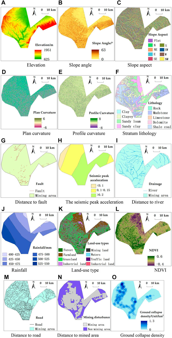
FIGURE 2. Landslide condition factors of the Fenxi coal mine. (A) Elevation, (B) Slope angle, (C) Slope aspect, (D) Plan curvature, (E) Profile curvature, (F) Stratum lithology, (G) Distance to fault, (H) The seismic peak acceleration, (I) Distance to river, (J) Rainfall, (K) Land-use type, (L) NDVI, (M) Distance to road, (N) Distance to mined area, (O) Ground collapse density.
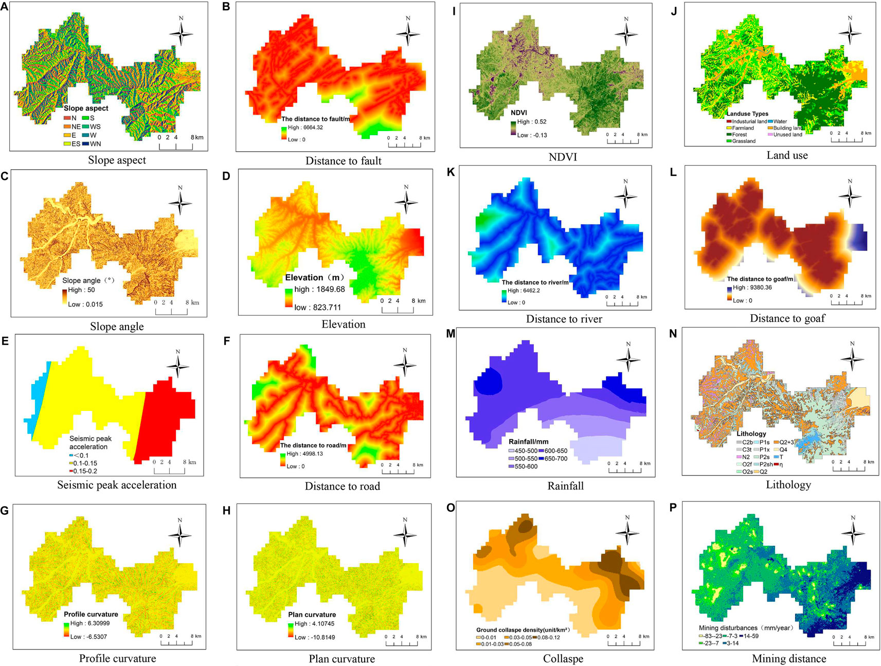
FIGURE 3. Landslide condition factors of the Xishan coal mine. (A) Slope aspect, (B) Distance to fault, (C) Slope angle, (D) Elevation, (E) Seismic peak acceleration, (F) Distance to road, (G) Profile curvature, (H) Plan curvature, (I) NDVI, (J) Land use, (K) Distance to river, (L) Distance to goaf, (M) Rainfall, (N) Lithology, (O) Collaspe, (P) Mining distance.
3 The selection of influencing factors
The occurrence of geological disasters is affected by various internal and external dynamics. It will not only destroy the ecological environment but also cause loss to people’s life and property. The selection of impact factors for landslides in mining areas is the primary task and the most important step for landslide susceptibility assessment. It can be said that the correct selection of impact factors directly determines the prediction accuracy of the final assessment model. According to the study of the geological, topographic, and survey data of the Fenxi mining area, the influencing factors can be divided into five categories: mining area factor, topographic factor, geological factor, environmental factor, and historical factor. This paper mainly adheres to the following two principles: 1) the relevant experience of the influencing factors selected in the previous study and 2) availability of data. Combining the aforementioned two principles, the topographic factors were finally obtained in this study: elevation, slope, aspect, and curvature (plane and profile curvature). Geological structural factors include stratum lithology, fault distance, and seismic peak acceleration; environmental factors include annual precipitation, normalized vegetation index, land use, road distance, and river distance; mining factors include goaf distance, mining disturbance, ground collapse density, and other factors; and historical factors include historical landslide point.
4 The mining landslide sensitivity evaluation model based on transfer learning
4.1 Transfer learning model
Transfer learning (TL) refers to applying the knowledge learned in auxiliary fields similar to but different target fields for learning according to the similarity between tasks, so as to effectively improve the learning efficiency of new tasks.
4.2 The mining landslide sensitivity evaluation model
First, the comprehensive selection of influencing factors is carried out through the obtained data, satellite images, and DEM data. In order to ensure the independence of the evaluation index, the first step is to use Pearson’s correlation coefficient to analyze the correlation of 16 indicators and eliminate the factors with high correlation. The results for profile curvature and mined-out disturbance factors were removed. The impact factor correlation is shown in Figure 4.
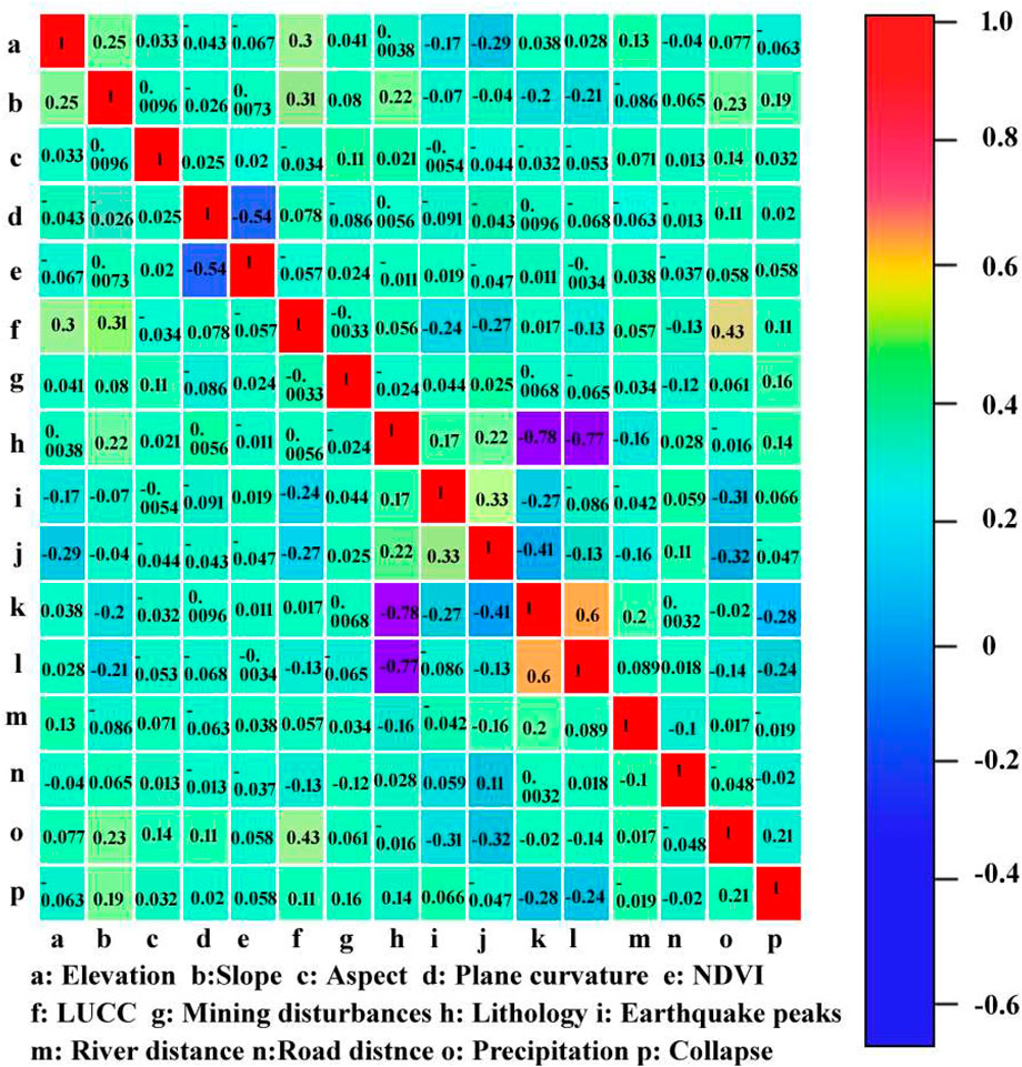
FIGURE 4. Pearson’s correlation coefficient plot for the 16 factors. (A) Elevation, (B) Slope, (C) Aspect, (D) Plane curvature, (E) NDVI, (F) LUCC, (G) Mining disturbances, (H) Lithology, (I) Earthquake peaks, (M) River distance, (O) Precipitation, (P) Collapse.
In Table 3, the correlation between 16 landslide condition factors (elevation, slope, aspect, plane curvature, profile curvature, lithology, distance to fault, peak earthquake acceleration, distance to river, precipitation, land use type, NDVI, distance to road, distance to mined area, LUCC, and ground collapse density) are given and represented by Elev, Slop, Aspe, Pl-c, Pr-c, Lith, Faul, Peak, Rive, Pre, Land, NDVI, Road, Mine, Lucc, and Coll, respectively.
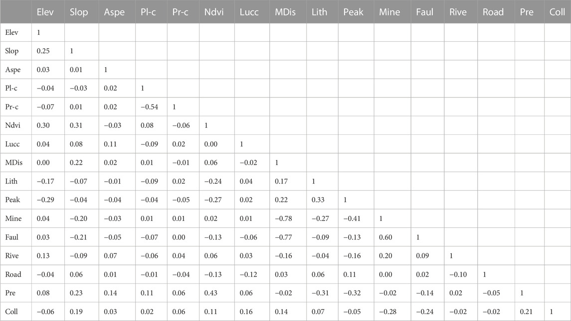
TABLE 3. Correlation between 16 condition factors.
The second step is to use the random forest model to score the importance of the input data and delete the factors with low impact on the landslide in the study area. We removed ground motion acceleration. The importance of the influencing factors is shown in Figure 5.
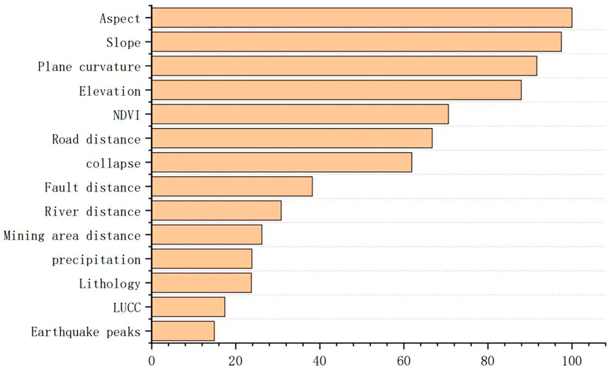
FIGURE 5. Importance of the influencing factors.
The third step is to calculate the KL divergence. In order to establish the evaluation model, it is necessary to analyze the similarity between the input factors of the two study areas. The values of the corresponding factors in the two study areas should be as similar as possible to achieve a better migration effect. Therefore, the KL difference was selected as the criterion to judge the similarity of infusion factors. KL divergence is often used to measure the numerical similarity of the corresponding influencing factors in two research areas. The full form of KL divergence is Kullback–Leibler divergence, which is mainly used to measure the similarity of probability distribution between two data. The KL divergence can be calculated by the following formula:
In the formula, P (x) and Q (x) represent the probability distribution of the two data, where KL (P‖Q) ≥ 0, and if and only if P = Q, KL (P‖Q) = 0. It can be concluded from the formula that the closer the value of KL divergence is to 0, the higher the degree of similarity between the two numbers. When the KL divergence is 0, it means that the two data are completely consistent. Based on the datasets of the Fenxi mining area and the ninth mine of the Xishan coal field, the KL divergence, an evaluation index, can be used to calculate the value of the KL divergence of the corresponding influencing factors of the two research areas. The table shows that the KL divergence of the data of each group in the two study areas reaches the highest with 0.67 (ground collapse density) and the lowest with 0.17 (lithology). After data similarity analysis, the number of neurons in the input layer of the neural network model is determined. The number of neurons in the input layer is determined as 13: elevation, slope, aspect, plane curvature, fracture distance, river distance, land use, highway distance, precipitation, normalized vegetation index (NDVI), lithology, lithological mining distance, and ground collapse density. The impact factor KL divergence is shown in Table 4.

TABLE 4. Statistical table of the impact factor KL divergence.
The entire flow chart is shown in Figure 6. First, image acquisition is carried out with the help of a satellite to obtain DEM data and geographic data, and then the spatial database is generated; the spatial database is divided into the sensitivity dataset of the Fenxi mining area and Xishan mining area; influencing factors are selected based on two datasets; the importance of influencing factors are ranked using random forests; based on the calculation of KL divergence, it is determined that the two datasets are similar; the basic model is built based on the Fenxi mining area; the model is transferred to No. 9 coal mine in Xishan Headquarters; and the comparison of sensitivity evaluation performance is performed by changing the transfer learning mode.
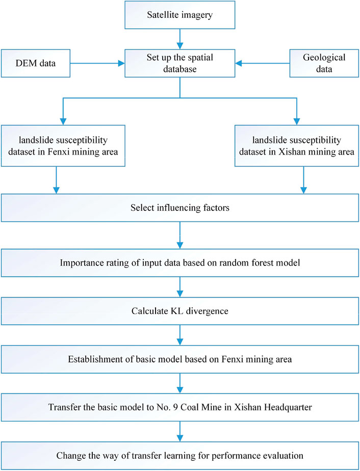
FIGURE 6. Entire flow chart.
5 Evaluation results
5.1 AUC value and ROC curve analysis
In Figure 7, model 1, model 2, and model 3 represent direct push, self-transfer, and inductive transfer learning, respectively. The training set of each model adopts single-factor binary logistic regression analysis and selects 15 variables related to coal mine landslide (p<0.05); the collinearity analysis of each variable shows that the corresponding tolerance is less than 1 and greater than 0.1, and the variance expansion factor (VIF) is less than 4; the test results show that there is no multiple collinearity among the variables included in the logistic regression. The ROC curve of LSP and its corresponding AUC value are shown in Figure 7. From the obtained AUC, we conclude that direct push transfer learning is a mechanical model transfer process, and the model to be transferred without training is difficult to meet the landslide prediction effect, so the value of AUC is relatively low, but the AUC value higher than 0.5 indicates that this model has a certain transfer effect. The AUC values of the other two models are both higher than 0.95 and the difference is almost the same, which means that both self-transfer and inductive transfer can better fit the problems in this study. However, from the perspective of an accuracy value, inductive transfer learning shows excellent evaluation efficiency in this area.
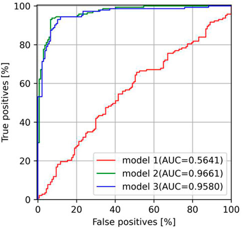
FIGURE 7. ROC and AUC for the three landslide susceptibility models.
5.2 Susceptibility map analysis
According to the classification standard of landslide sensitivity in the coal mine area of Jiukuang mine, Xishan Headquarters, three landslide sensitivity maps were obtained and converted into a grid format. The three LSP maps drawn by using the three models are shown in Figure 8. Figure 8 shows that there is a big difference between direct push transfer learning and self-transfer and inductive transfer partition in the beginning of the three algorithms, indicating that the effect of direct push transfer learning is not ideal. In fact, inductive transfer learning and self-transfer show quite good performance and maintain a high degree of consistency with the distribution of geological hazards in the study area.
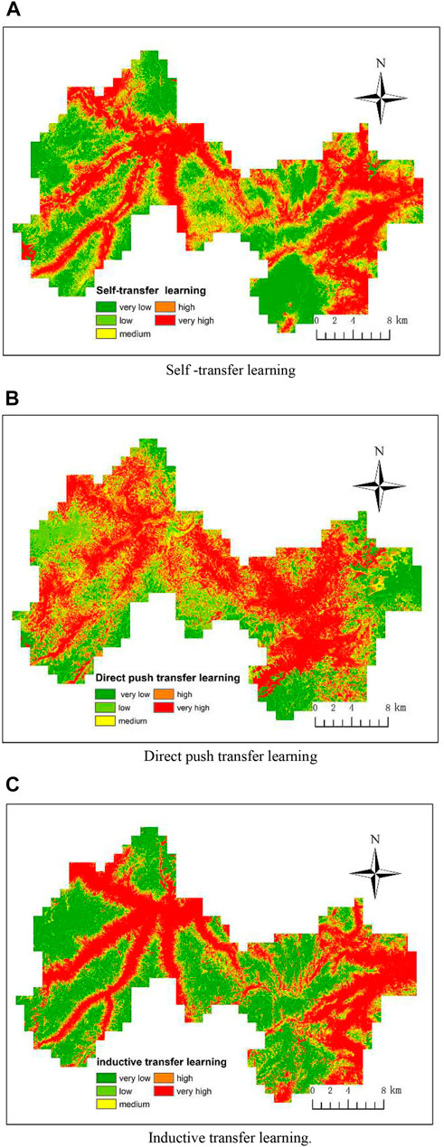
FIGURE 8. Landslide susceptibility maps using the three models. (A) Self -transfer learning, (B) Direct push transfer learning, (C) Inductive transfer learning.
In order to compare the two spatial LSP indices, the characteristics of landslide distribution and their area percentage under each susceptibility range are shown in Table 5.
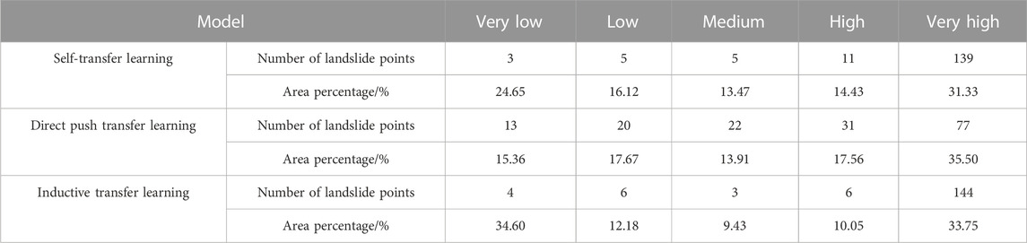
TABLE 5. Distributions of landslides and area percentage under different susceptibility standards.
Table 5 shows that the region with the highest landslide sensitivity has 139, 77, and 144 landslide points based on self-transfer learning, direct push transfer learning, and inductive transfer learning, respectively. The regional distributions of highest landslide sensitivity based on self-transfer learning, direct push transfer learning, and inductive transfer learning are 31.33%, 35.50%, and 33.75%, respectively. The landslide disaster sites with the low-sensitivity level are very low in all the surveys (Gokceoglu et al., 2005; Su et al., 2017a). Therefore, inductive transfer learning is considered one of the best models of LSP algorithm.
6 Analysis of model building
Through the aforementioned analysis, it is found that the distribution of a coal mine landslide was controlled by mining-related factors. The results show that the incident is not caused by coal mining, but the mining factors play a major role in promoting the coal mine landslide. In general, the landform is the necessary condition of forming a geological hazard, stratigraphic lithology of a geological disaster form provides the material foundation, and the deformation and destruction of a geological structure upon geological disasters have a direct or indirect control effect; rainfall is the main triggering factor of geological disasters, and mining disturbance, roads, and other human engineering activities have intensified the formation of geological hazards.
The greatest contribution of distance to road is probably the fact that road construction changes the slope, creates a steep slope, and causes instability of the slope. In terms of mechanical properties, profile curvature and ground collapse density are also relatively important factors. The curvature factor represents the inhomogeneity of the surface. The greater the unevenness, the more uneven the force on the slope is, and the greater the possibility of geological disasters (Chen and Li, 2020). Theoretically, ground collapse density plays an important role in the occurrence of geological disasters (Hait and Head-Gordon, 2020; Zhang et al., 2022b; Zhou et al., 2022). The ground collapse significantly affects the surface stability of the mining area. A large amount of ground collapse damages the surface morphology and stability.
The transfer learning model has been widely used in many research studies, which can well reflect the basic characteristics of its corresponding model type (Huang et al., 2020; Guo et al., 2021; Li et al., 2022; Zhuo et al., 2022). Compared to other deep learning algorithms, transfer learning has fewer restrictions on variables and has the advantages of high computational efficiency, high accuracy, and low debugging cost (Su et al., 2017b; Huang et al., 2018; Liao et al., 2021). It can make up for the problem of insufficient data in the target region, has strong generalization ability, and does not need a large amount of data in the process of model migration, so it becomes a relatively better algorithm.
7 Conclusion
In this study, the Fenxi coal mine area is taken as the study area, 265 landslides and 16 condition factors are recorded, and a sensitive basic model is established. The model is transferred to the coal mine area of No. 9 coal mine in Xishan coal field, and different transfer learning methods are introduced; the results of AUC accuracy and landslide distribution characteristics show that inductive transfer learning is more suitable for landslide sensitivity evaluation in the Jiujiu coal mine area of Xishan coal field. The identification of landslide sensitivity in the mining area facilitates to accurately determine the factors causing landslide in mining areas. The zoning performance comparison of the sensitivity of a coal mine landslide based on the migration learning methods can better evaluate the impact of landslide on different mines so as to better prevent geological disasters in mines.
Data availability statement
The original contributions presented in the study are included in the article/Supplementary Material; further inquiries can be directed to the corresponding author.
Author contributions
YZ and YY contributed to the conception and design of the study. YZ contributed to methodology, software, formal analysis, investigation, data curation, supervision of the study, and the first draft of the manuscript. YY and JZ contributed to validation of the study. YW contributed to resources of the study. JZ contributed to visualization of the study. YY contributed to project administration, funding acquisition, and writing—review and editing of the study. All authors contributed to manuscript revision, read, and approved the submitted version.
Funding
This research was supported by the Natural Science Foundation of China (no. 42171424) and National Key Research and Development Program of China (no. 2018YFB0505402).
Conflict of interest
The authors declare that the research was conducted in the absence of any commercial or financial relationships that could be construed as a potential conflict of interest.
Publisher’s note
All claims expressed in this article are solely those of the authors and do not necessarily represent those of their affiliated organizations, or those of the publisher, the editors, and the reviewers. Any product that may be evaluated in this article, or claim that may be made by its manufacturer, is not guaranteed or endorsed by the publisher.
References
Chau, K. T., Sze, Y. L., Fung, M. K., Wong, W. Y., Fong, E. L., and Chan, L. C. P. (2004). Landslide hazard analysis for Hong Kong using landslide inventory and GIS. Comput. Geosciences 30, 429–443. doi:10.1016/j.cageo.2003.08.013
Chen, G., and Li, S. (2020). Research on location fusion of spatial geological disaster based on fuzzy SVM. Comput. Commun. 153, 538–544. doi:10.1016/j.comcom.2020.02.033
Domínguez-Cuesta, M. J., Jiménez-Sánchez, M., and Berrezueta, E. (2007). Landslides in the central coalfield (Cantabrian Mountains, NW Spain): Geomorphological features, conditioning factors and methodological implications in susceptibility assessment. Geomorphology 89, 358–369. doi:10.1016/j.geomorph.2007.01.004
Feizizadeh, B., and Blaschke, T. (2014). An uncertainty and sensitivity analysis approach for GIS-based multicriteria landslide susceptibility mapping. Int. J. Geogr. Inf. Sci. 28 (3), 610–638. doi:10.1080/13658816.2013.869821
Ghorbanzadeh, O., Feizizadeh, B., and Blaschke, T. (2018). Multi-criteria risk evaluation by integrating an analytical network process approach into GIS-based sensitivity and uncertainty analyses. Geomatics, Nat. Hazards Risk 9 (1), 127–151. doi:10.1080/19475705.2017.1413012
Ghorbanzadeh, O., Shahabi, H., Crivellari, A., Homayouni, S., Blaschke, T., and Ghamisi, P. (2022). Landslide detection using deep learning and object-based image analysis. Landslides 19, 929–939. doi:10.1007/s10346-021-01843-x
Ghorbanzadeh, O., Xu, Y., Ghamis, P., Kopp, M., and Kreil, D. Landslide4sense (2022). Landslide4Sense: Reference benchmark data and deep learning models for landslide detection. IEEE Trans. Geoscience Remote Sens. 60, 1–17. doi:10.1109/tgrs.2022.3215209
Ghorbanzadeh, O., Xu, Y., Zhao, H., Wang, J., Zhong, Y., Zhao, D., et al. (2022). The outcome of the 2022 landslide4sense competition: Advanced landslide detection from multisource satellite imagery. IEEE J. Sel. Top. Appl. Earth Observations Remote Sens. 15, 9927–9942. doi:10.1109/jstars.2022.3220845
Gokceoglu, C., Sonmez, H., Nefeslioglu, H. A., Duman, T. Y., and Can, T. (2005). The 17 March 2005 Kuzulu landslide (Sivas, Turkey) and landslide-susceptibility map of its near vicinity. Eng. Geol. 81, 65–83. doi:10.1016/j.enggeo.2005.07.011
Guo, Z., Shi, Y., Huang, F., Fan, X., and Huang, J. (2021). Landslide susceptibility zonation method based on C5.0 decision tree and K-means cluster algorithms to improve the efficiency of risk management. Geosci. Front. 12 (6)–101249. doi:10.1016/j.gsf.2021.101249
Hait, D., and Head-Gordon, M. (2020). Highly accurate prediction of core spectra of molecules at density functional theory cost: Attaining sub-electronvolt error from a restricted open-shell Kohn-Sham approach. J. Phys. Chem. Lett. 11 (3), 775–786. doi:10.1021/acs.jpclett.9b03661
Heckerman, D. (2013). Probabilistic interpretation for mycin’s certainty factors. Mach. Intell. Pattern Recognit. 4, 9–20.
Heleno, S., Matias, M., Pina, P., and Sousa, A. J. (2016). Semiautomated object-based classification of rain-induced landslides with VHR multispectral images on Madeira Island. Nat. Hazards Earth Syst. Sci. 16 (4), 1035–1048. doi:10.5194/nhess-16-1035-2016
Huang, F., Cao, Z., Guo, J., Jiang, S., Li, S., and Guo, Z. (2020). Comparisons of heuristic, general statistical and machine learning models for landslide susceptibility prediction and mapping. Catena 191–104580. doi:10.1016/j.catena.2020.104580
Huang, F., Yin, K., Jiang, S., Huang, J., and Cao, Z. (2018). Landslide susceptibility evaluation based on cluster analysis and support vector machine. J. Rock Mech. Eng. 37 (1), 156–167.
Huo, W., Li, Z., Wang, J., Yao, C., Zhang, K., and Huang, Y. (2019). Multiple hydrological models comparison and an improved Bayesian model averaging approach for ensemble prediction over semi-humid regions. Stoch. Environ. Res. Risk Assess. 33, 217–238. doi:10.1007/s00477-018-1600-7
Kang, C., Chen, W. W., Zhang, F. Y., He, F. G., and Song, B. H. (2011). Application of deterministic model to analyzing stability of hillslope of loess gully area. Rock Soil Mech. 32 (1), 207–210.
Li, Q., Song, D., Yuan, C., and Nie, W. (2022). An image recognition method for the deformation area of open-pit rock slopes under variable rainfall. Measurement 188–110544. doi:10.1016/j.measurement.2021.110544
Liao, L., Du, L., and Guo, Y. (2021). Semi-supervised SAR target detection based on an improved faster R-CNN. Remote Sens. 14 (1), 143. doi:10.3390/rs14010143
Liu, Y., Zhang, Z., Liu, X., Wang, L., and Xia, X. (2021). Efficient image segmentation based on deep learning for mineral image classification. Adv. Powder Technol. 32 (10), 3885–3903. doi:10.1016/j.apt.2021.08.038
Ma, Z., Mei, G., and Piccialli, F. (2021). Machine learning for landslides prevention: A survey. Neural Comput. Appl. 33 (17), 10881–10907. doi:10.1007/s00521-020-05529-8
Montgomertry, D. R., and Dietrich, W. E. (1994). A physically based model for the topographic control on shallow landsliding. Water Resour. Res. 30 (4), 1153–1171. doi:10.1029/93wr02979
Neto, A. X., De Morais, J. O., and Ciarlini, C. (2018). Modern and relict sedimentary systems of the semi-arid continental shelf in NE Brazil. J. S. Am. Earth Sci. 84 (jul), 56–68. doi:10.1016/j.jsames.2018.03.004
Pack, R. T., Tarboton, D. G., and Goodwin, C. N. (1998)., 9. Vancouver, Canada, 21–25.The SINMAP approach to terrain stability mapping, Proc. 8th Congr. Int. Assoc. Eng. Geol.
Peart, M. R., Ng, K. Y., and Zhang, D. D. (2005). Landslides and sediment delivery to a drainage system: Some observations from Hong Kong. J. Asian Earth Sci. 25 (5), 821–836. doi:10.1016/j.jseaes.2004.08.004
Pham, V. D., Nguyen, Q. H., Nguyen, H. D., Pham, V. M., Vu, V. M., and Bui, Q. T. (2020). Convolutional neural network-optimized moth flame algorithm for shallow landslide susceptible analysis. IEEE Access 8, 32727–32736. doi:10.1109/access.2020.2973415
Piralilou, S. T., Shahab, H., Jarihani, B., Ghorbanzadeh, O., Blaschke, T., Gholamnia, K., et al. (2019). Landslide detection using multi-scale image segmentation and different machine learning models in the higher Himalayas. Remote Sens. 11 (21), 2575. doi:10.3390/rs11212575
Shi, J. S., Zhang, Y. S., Dong, C., and Wu, S. R. (2005). GIS⁃based landslide hazard zonation of the new Badong county site. J. Earth 26 (3), 275–282.
Shi, Y., Xu, X., Xi, J., Hu, X., Hu, D., and Xu, K. (2022). Learning to detect 3D symmetry from single-view RGB-D images with weak supervision. IEEE Trans. Pattern Analysis Mach. Intell. 2022, 1–15. doi:10.1109/tpami.2022.3186876
Shortliffe, E. H., and Buchanan, B. G. (1975). A model of inexact reasoning in medicine. Math. Biosci. 23 (3), 351–379. doi:10.1016/0025-5564(75)90047-4
Su, Q. M., Zhang, J., Zhao, S. M., Wang, L., Liu, J., and Guo, J. L. (2017). Comparative assessment of three nonlinear approaches for landslide susceptibility mapping in a coal mine area. ISPRS Int. J. Geo-Information 6, 228. doi:10.3390/ijgi6070228
Su, Q., Zhao, S., and Guo, J. (2017). Numerical modeling and classification of surface landslide hazard sensitivity in Huoxi Coal Mine. J. Geo-Information Sci. 19, 1613–1622.
Tian, C. S., Liu, X., and Wang, J. (2016). Geohazard susceptibility assessment based on CF model and logistic regression models in Guangdong. Hydrogeology Eng. Geol. 43 (6), 154–161.
Wang, G., Zhao, B., Lan, R., Liu, D., Wu, B., Li, Y., et al. Experimental study on failure model of tailing dam overtopping under heavy rainfall. Lithosphere, 2022, 2022(Special 10), 5922501, doi:10.2113/2022/5922501
Wen, X., Fan, X. M., Chen, L., and Liu, S. K. (2022). Susceptibility assessment of geological disasters based on an information value model: A case of gulin county in southeast sichuan. Bull. Geol. Sci. Technol. 41 (2), 290–299.
Xiang, L., Cui, P., Zhang, J., Huang, D., Fang, H., and Zhou, X. (2010). Sensitivity analysis on influencing factors of earthquake induced landslide disaster in Wenchuan County. J. Sichuan Univ. Eng. Sci. Ed. 42, 105–112.
Yang, G., Xu, P. H., Cao, C., Zhang, W., Lan, Z. G., Chen, J. Q., et al. (2019). Assessment of regional landslide susceptibility based on combined model of certainty factor method. J. Eng. Geol. 27 (5), 1153–1163.
Yang, X., Zhang, S., Wen, J., and Xu, M. (2018). Spatial pattern of herbaceous plant species diversity and its changes due to simulated warming in the forest community of the Luliang Mountains. Acta Ecol. Sin. 38 (18), 6642–6654.
Yin, K. L., and Zhu, L. L. (2001). Landslide hazard zonation and application of GIS. Earth Sci. Front. 8 (2), 279–284.
Youssef, A. M., and Pourghasemi, H. R. (2021). Landslide susceptibility mapping using machine learning algorithms and comparison of their performance at Abha Basin, Asir Region, Saudi Arabia. Geosci. Front. 12 (2), 639–655. doi:10.1016/j.gsf.2020.05.010
Zhan, C., Dai, Z., Soltanian, M. R., and de Barros, F. P. J. (2022). Data-worth analysis for heterogeneous subsurface structure identification with a stochastic deep learning framework. Water Resour. Res. 58 (11)–e2022WR033241. doi:10.1029/2022wr033241
Zhang, X., Ma, F., Dai, Z., Wang, J., Chen, L., Ling, H., et al. (2022). Radionuclide transport in multi-scale fractured rocks: A review. J. Hazard. Mater. 424 (Pt C)–127550. doi:10.1016/j.jhazmat.2021.127550
Zhang, Y., Luo, J., Li, J., Mao, D., Zhang, Y., Huang, Y., et al. (2022). Fast inverse-scattering reconstruction for airborne high-squint radar imagery based on Doppler centroid compensation. IEEE Trans. Geoscience Remote Sens. 60, 1–17. doi:10.1109/tgrs.2021.3069499
Zhong, Y. X., and Hu, B. Q. (2013). Theoretical explanation in the process of map spatial cognition. J. Guilin Univ. Technol. 33 (2), 307–311.
Zhou, G., Yang, F., and Xiao, J. (2022). Study on pixel entanglement theory for imagery classification. IEEE Trans. Geoscience Remote Sens. 60, 1–18. doi:10.1109/tgrs.2022.3167569
Zhu, Q., Zhang, M. D., Ding, Y. L., Zeng, H. W., Wang, W., and Liu, F. (2021). Fuzzy logic approach for regional landslide susceptibility analysis constrained by spatial characteristics of environmental factors. Geomatics Inf. Sci. Wuhan Univ. 46 (10), 1431–1440.
Keywords: landslide susceptibility zoning, transfer learning, multi-field information atlas, Xishan coal mine area, Shanxi Province
Citation: Zhang Y, Yang Y, Zhang J and Wang Y (2023) Sensitivity study of multi-field information maps of typical landslides in mining areas based on transfer learning. Front. Earth Sci. 11:1105985. doi: 10.3389/feart.2023.1105985
Received: 23 November 2022; Accepted: 09 January 2023;
Published: 24 January 2023.
Edited by:
Omid Ghorbanzadeh, Institute of Advanced Research in Artificial Intelligence (IARAI), AustriaReviewed by:
Sepideh Piralilou, University of Salzburg, AustriaHejar Shahabi, INRS Eau Terre Environnement, Canada
Copyright © 2023 Zhang, Yang, Zhang and Wang. This is an open-access article distributed under the terms of the Creative Commons Attribution License (CC BY). The use, distribution or reproduction in other forums is permitted, provided the original author(s) and the copyright owner(s) are credited and that the original publication in this journal is cited, in accordance with accepted academic practice. No use, distribution or reproduction is permitted which does not comply with these terms.
*Correspondence: Yanzhao Yang, empxeXgyMDIyQDEyNi5jb20=, eWFuZ3l6QGlnc25yci5hYy5jbg==